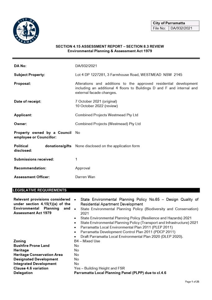
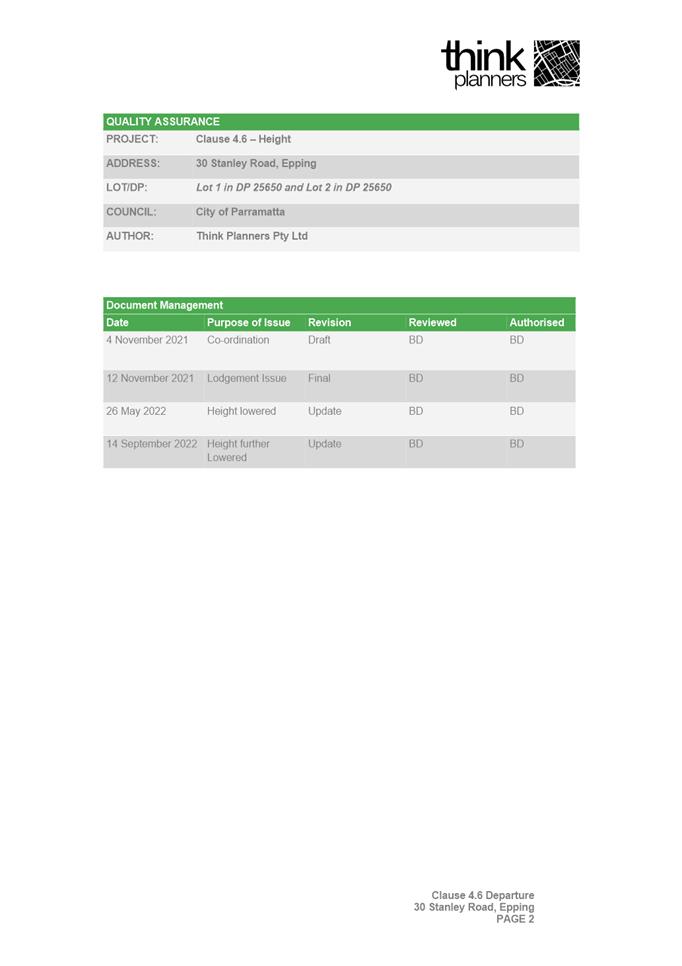
NOTICE OF Local Planning
Panel MEETING
PUBLIC AGENDA
A Local Planning Panel meeting will be held via
audio-visual means on Tuesday, 20 December 2022 at 3:30pm.
Bryan Hynes
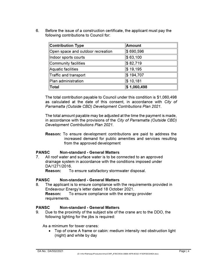
ACTING CHIEF EXECUTIVE OFFICER
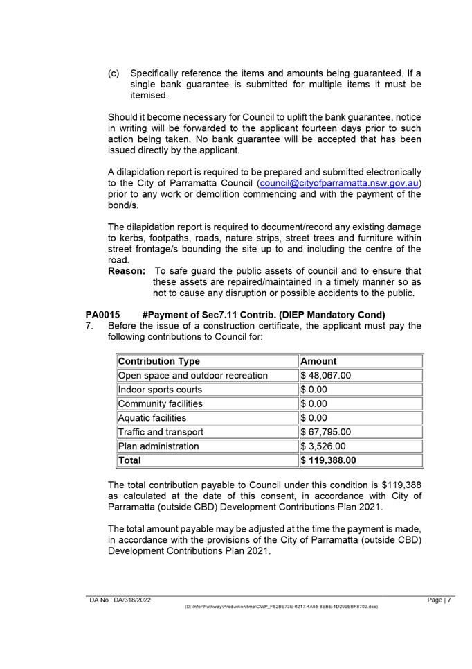
THIS PAGE LEFT BLANK INTENTIONALLY
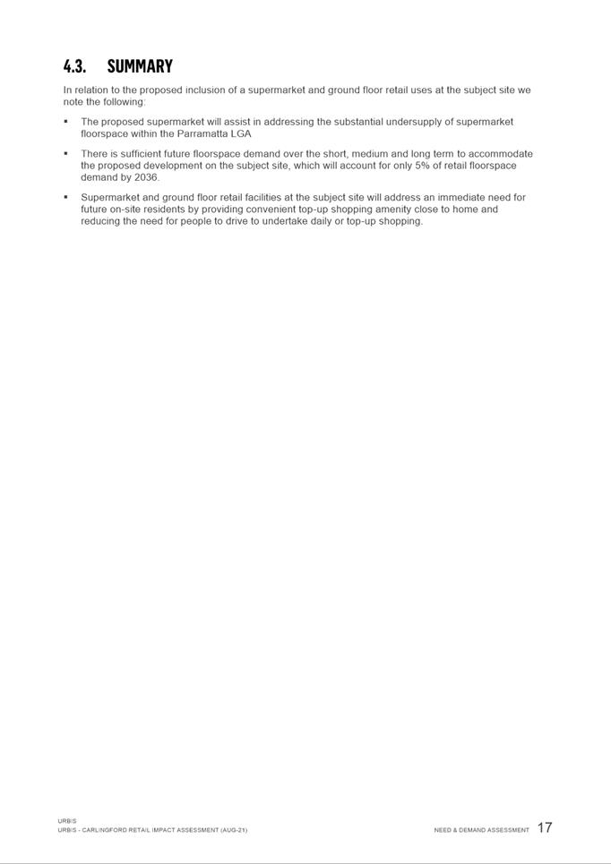
1 ACKNOWLEDGMENT
OF THE TRADITIONAL OWNERS OF LAND
The City of
Parramatta Council acknowledges the Burramattagal people of The Darug Nation as
the traditional owners of land in Parramatta and pays its respects to their
ancient culture and to their elders, past, present and emerging.
2 WEBCASTING
ANNOUNCEMENT
This public
meeting will be recorded. The recording will be archived and available on
Council’s website.
All care is taken to maintain your
privacy; however if you are in attendance in the public gallery, you should be
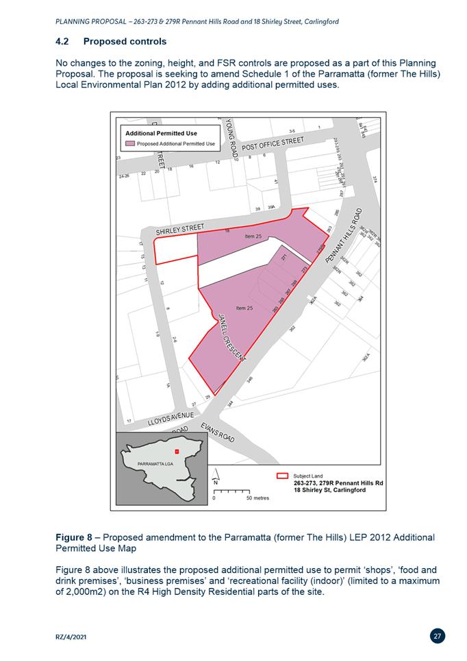
aware that your presence may be recorded.
3 APOLOGIES
4 DECLARATIONS
OF INTEREST
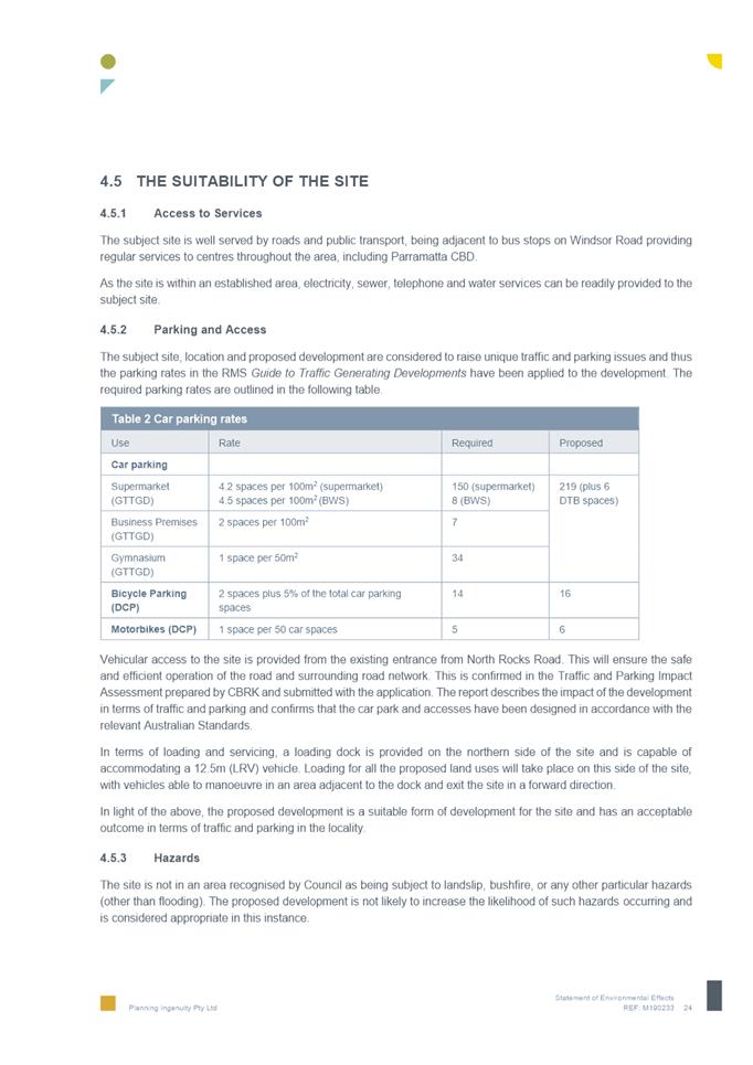
5 Reports - Development Applications
5.1 OUTSIDE
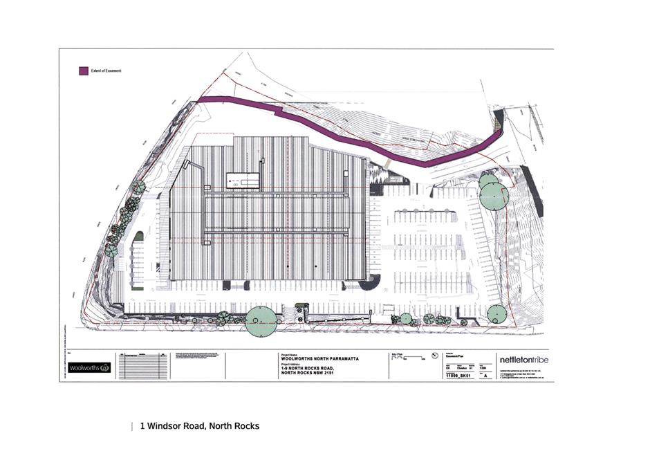
PUBLIC MEETING: 1 Windsor Road, NORTH ROCKS, NSW, 2151 (Lot 61 DP 1264730)...................................................................... 6
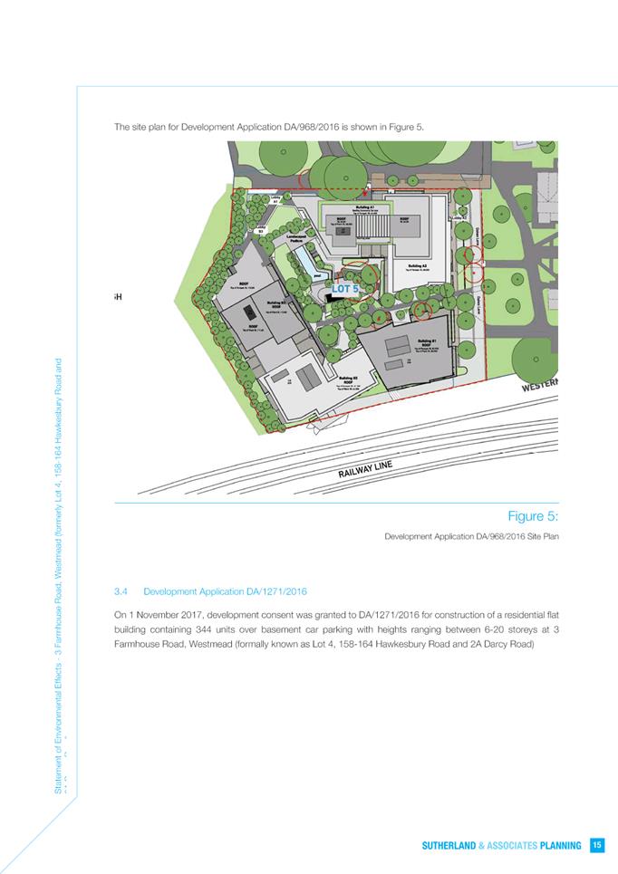
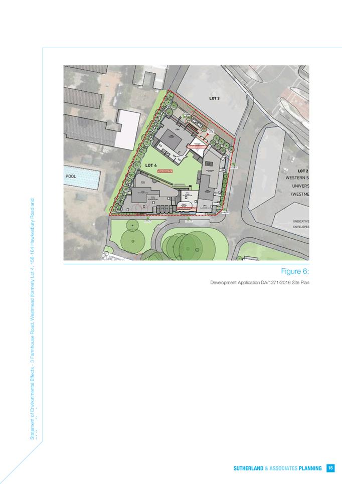
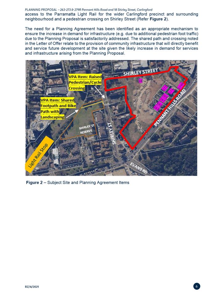
5.2 OUTSIDE
PUBLIC MEETING: 3 Farmhouse Road, WESTMEAD, NSW, 2145 (Lot 4 in DP 1227281)................................................................ 216
5.3 OUTSIDE
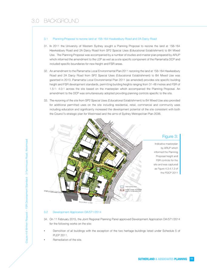
PUBLIC MEETING: 30 Stanley Road, EPPING (Lot 1 DP 25650, Lot 2 DP 25650).................................................................................... 453
6 Reports -
Planning Proposals
6.1 Post
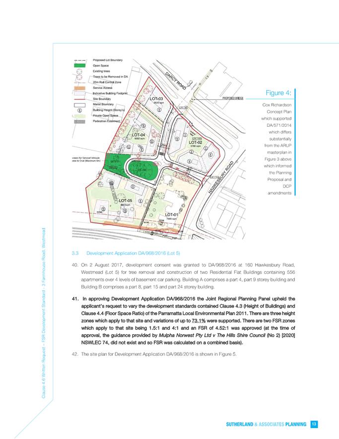
Exhibition: Planning Proposal and Draft Planning Agreement for 263-273 &
279R Pennant Hills Road and 18 Shirley Street, Carlingford. 518
Development Applications
20 December 2022
5.1 OUTSIDE
PUBLIC MEETING: 1 Windsor Road, NORTH ROCKS, NSW, 2151 (Lot 61 DP 1264730)................................................................................................. 6
5.2 OUTSIDE
PUBLIC MEETING: 3 Farmhouse Road, WESTMEAD, NSW, 2145 (Lot 4 in DP 1227281)........................................................................................... 216
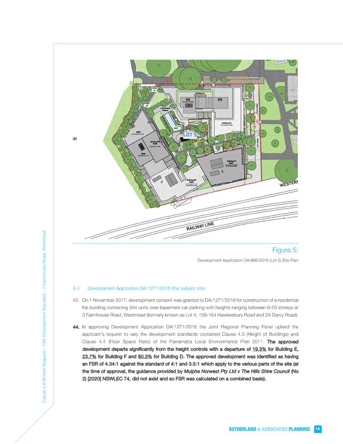
5.3 OUTSIDE
PUBLIC MEETING: 30 Stanley Road, EPPING (Lot 1 DP 25650, Lot 2 DP 25650)....................................................................................................... 453
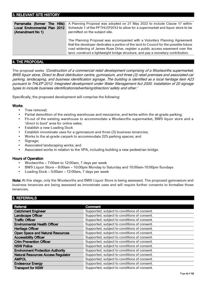
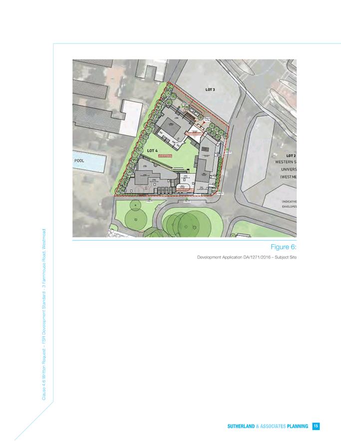
Local Planning Panel 20 December 2022 Item
5.1
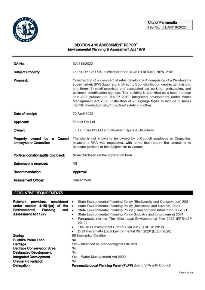
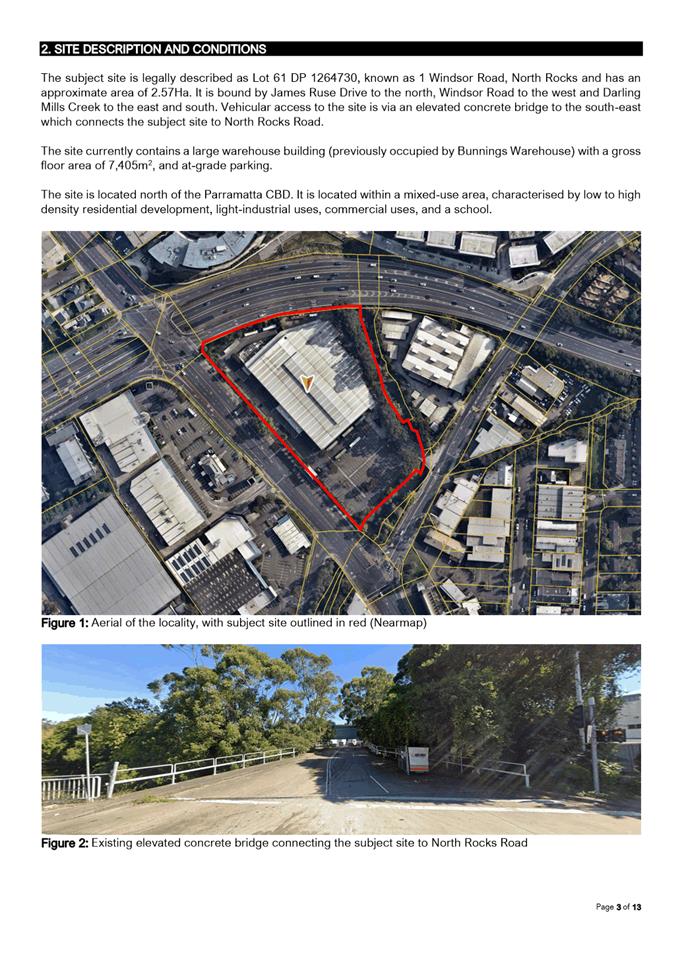
ITEM NUMBER 5.1
SUBJECT OUTSIDE PUBLIC MEETING: 1 Windsor Road, NORTH ROCKS, NSW, 2151 (Lot
61 DP 1264730)
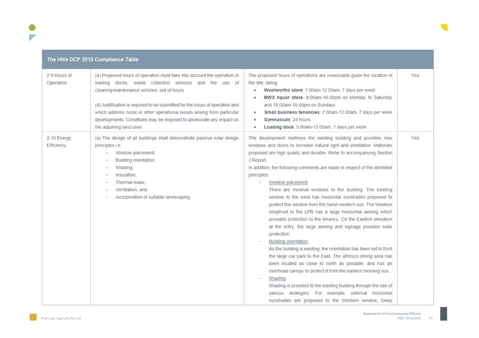
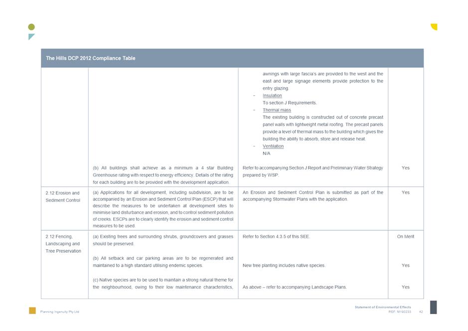
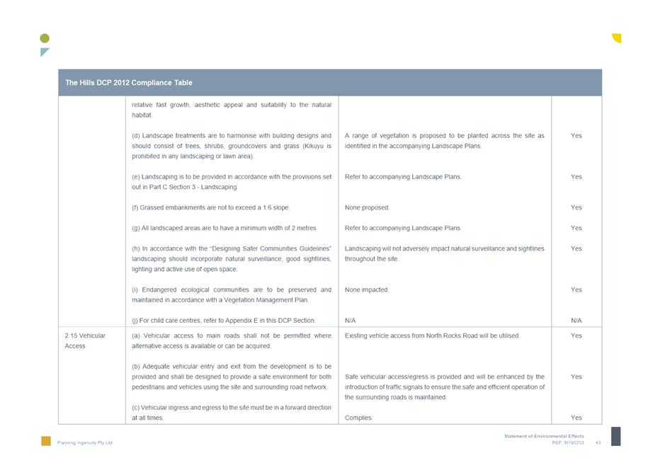
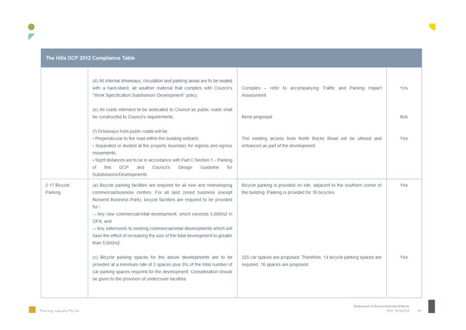
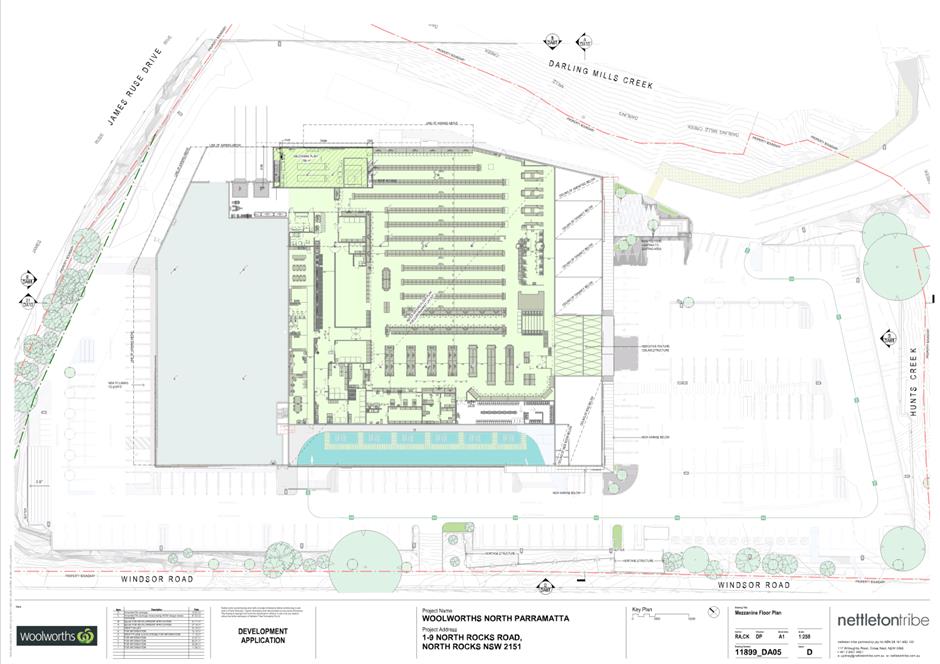
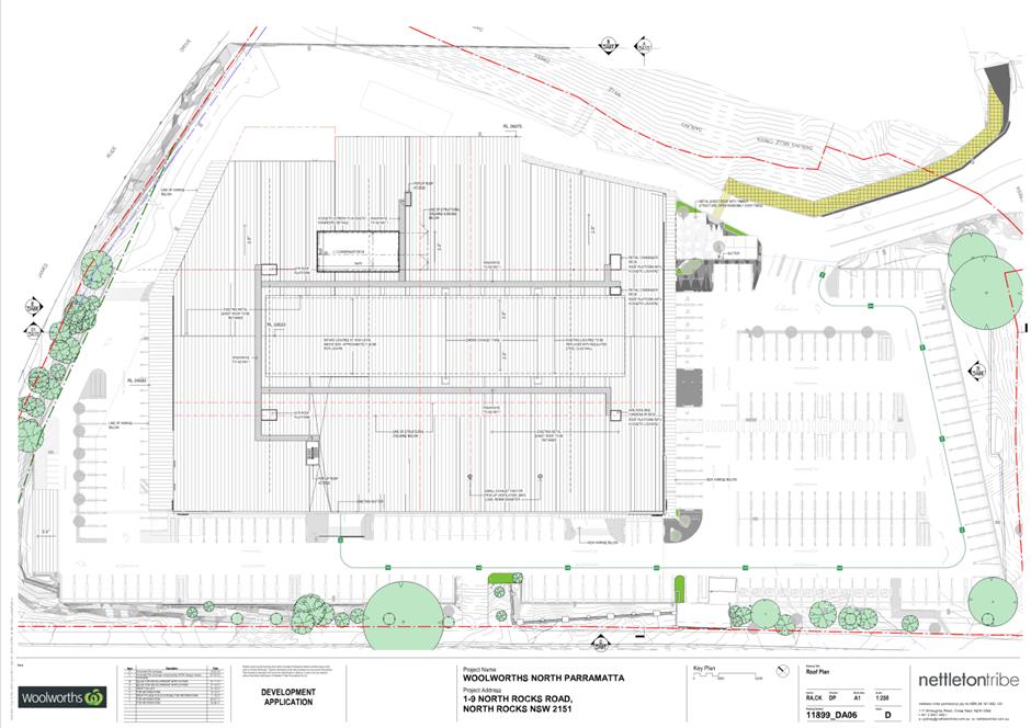
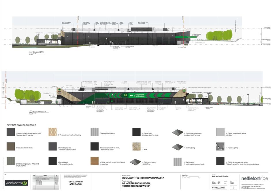
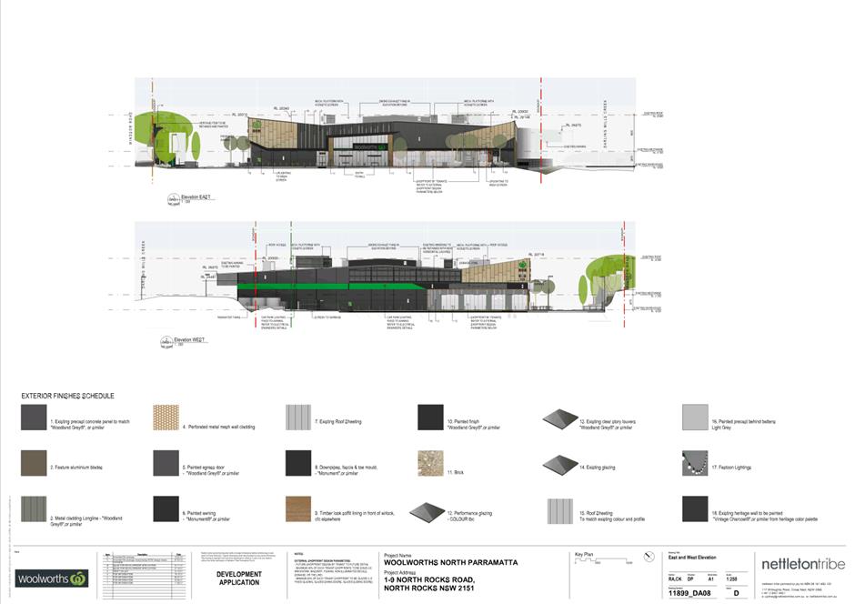
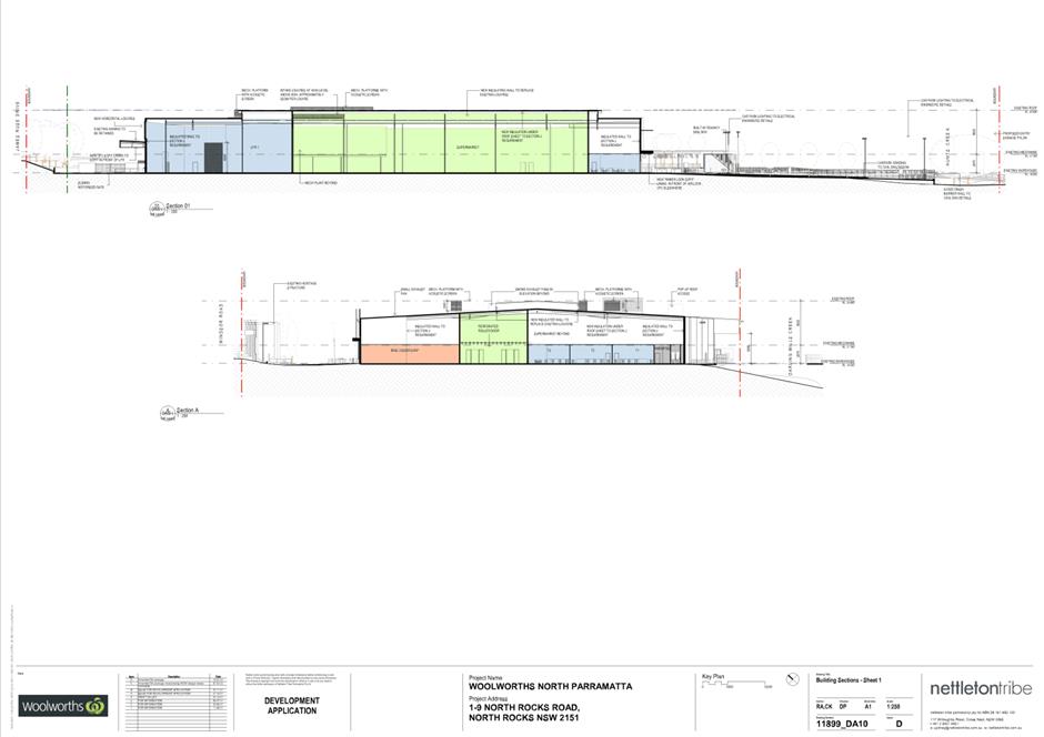
DESCRIPTION Construction of a commercial retail development comprising of a
Woolworths supermarket, BWS liquor store, Direct to Boot distribution centre,
gymnasium, and three (3) retail premises and associated car parking,
landscaping, and business identification signage. The building is identified as
a local heritage item A23 pursuant to THLEP 2012. The proposal is Integrated
Development under Water Management Act 2000.
REFERENCE DA/318/2022 - D08693308
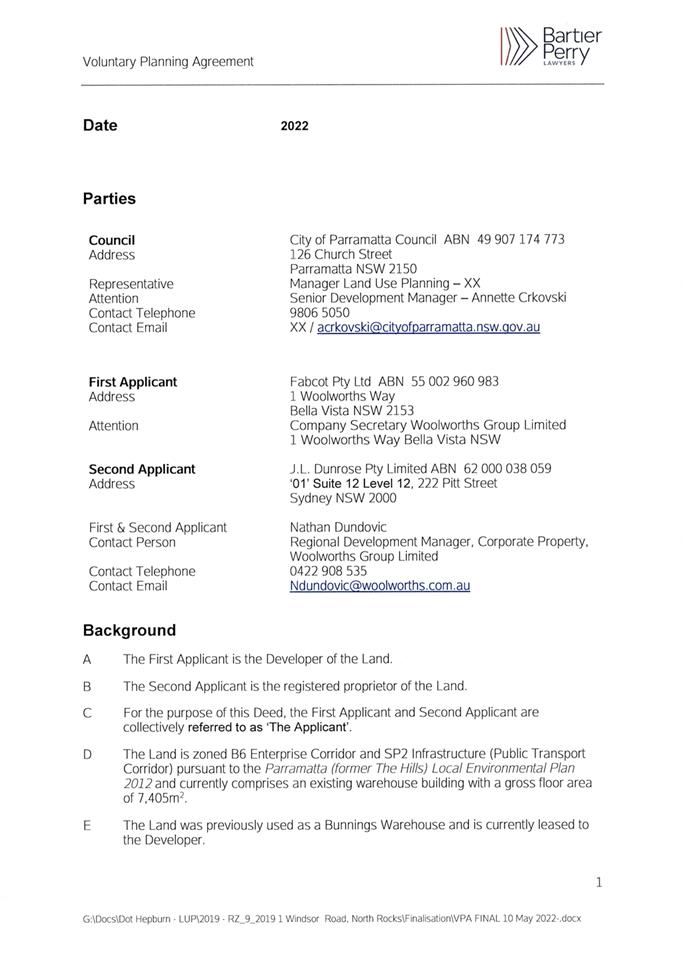
APPLICANT/S Fabcot Pty Ltd
OWNERS J L Dunrose Pty Ltd; Newtown Dyers & Bleachers
REPORT OF Group
Manager Development and Traffic Services
RECOMMENDED Approval
DATE OF REPORT 30 November 2022
REASON FOR
REFERRAL TO LPP
The application is being reported to Parramatta Local
Planning Panel, as there is a Voluntary Planning Agreement associated with this
DA.
EXECUTIVE SUMMARY
Development Application DA/318/2022 was lodged on 20 April
2022 for the ‘Construction of a
commercial retail development comprising of a Woolworths supermarket, BWS
liquor store, Direct to Boot distribution centre, gymnasium, and three (3)
retail premises and associated car parking, landscaping, and business
identification signage. The building is identified as a local heritage item A23
pursuant to THLEP 2012. Integrated development under Water Management Act 2000.
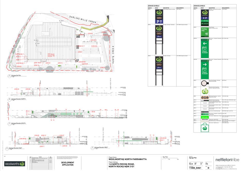
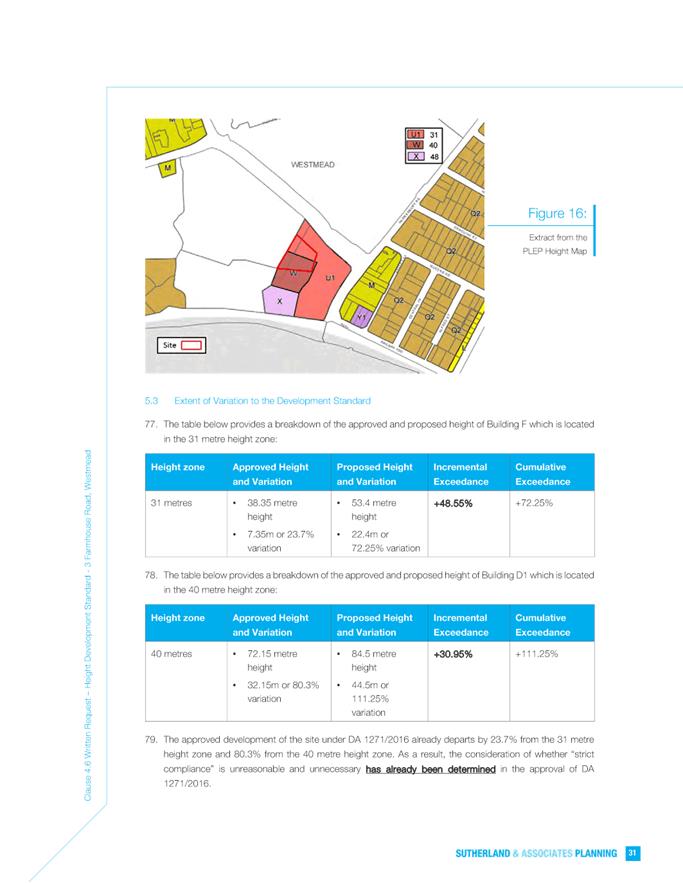
Installation of 20 signage types to include business identification/advertising/
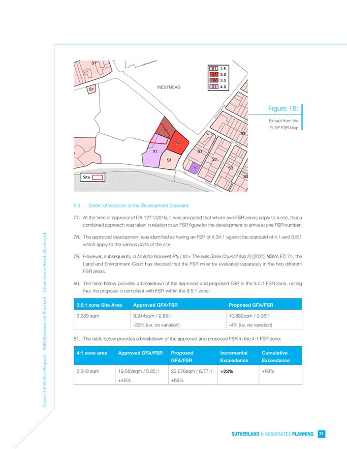
direction/ safety and other’.
The application
is being referred to Parramatta Local Planning Panel due to a Voluntary
Planning Agreement (‘VPA’) being negotiated between Council and the
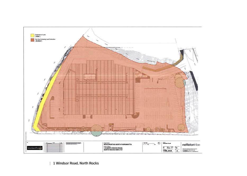
developer. The VPA requires that the developer dedicate a portion of the
land to Council for the possible future road widening of James Ruse Drive,
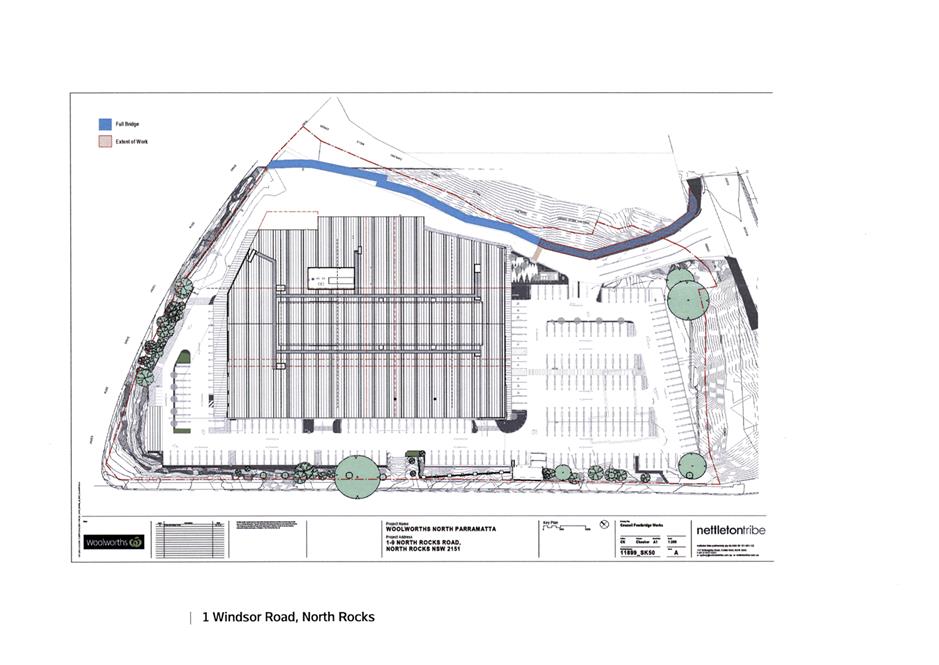
register a public access easement over the land, construct a lightweight bridge
structure, and pay a monetary contribution. The VPA was negotiated to accompany
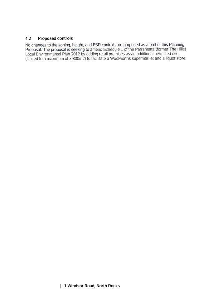
a Planning Proposal to allow a site-specific clause to allow up to 3,800m2
of retail GFA on the subject site.
In accordance
with the Consolidated Parramatta Notification Plan the Development Application
was notified and advertised on 29 April to 27 May 2022. No submissions were
received during the notification period.
Section 4.15
Assessment Summary
The
application has been assessed relative to section 4.15 of the Environmental
Planning and Assessment Act 1979, taking into consideration all relevant
state and local planning controls.
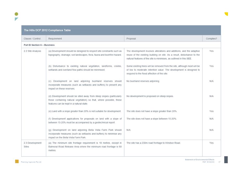
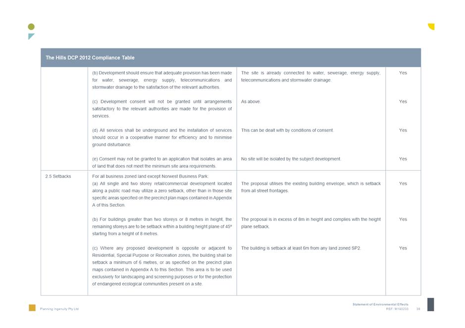
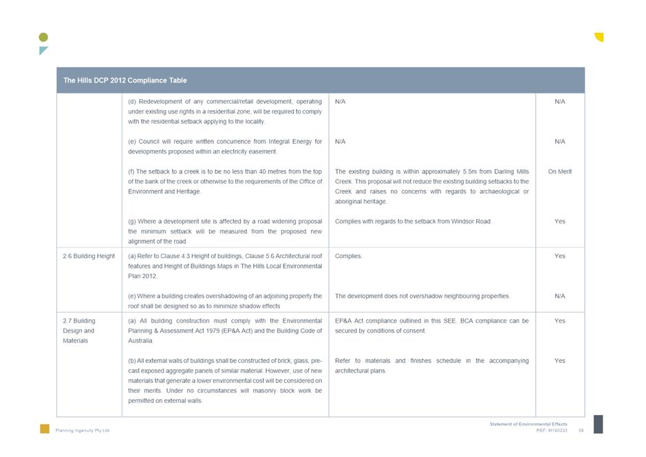
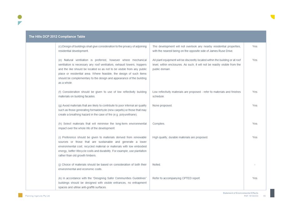
The proposed
development seeks alterations and additions to an existing building, previously
used as a Bunnings Warehouse and repurpose it as a Woolworths Supermarket, with
associated BWS Liquor Store and Direct to Booth facilities. The proposal will
also include three (3) innominate business premises tenancies and a gymnasium
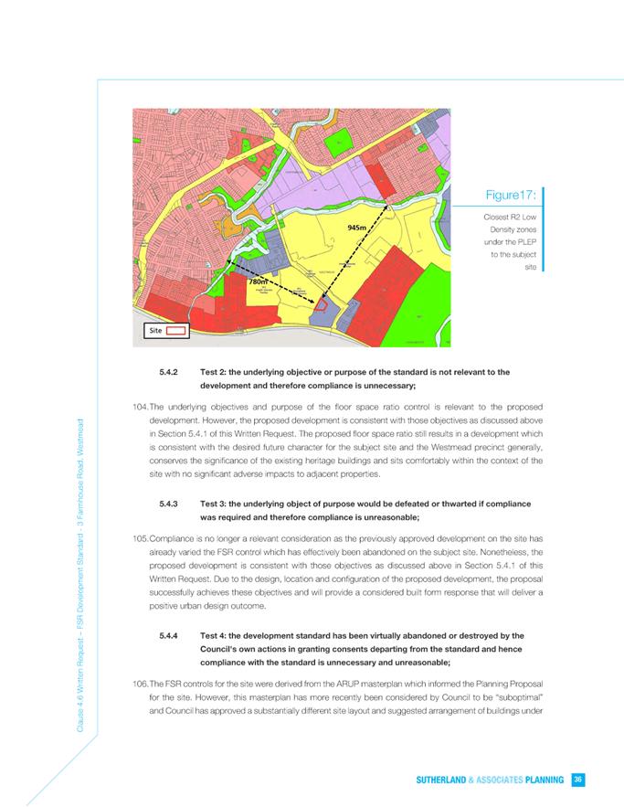
tenancy. These innominate tenancies will require future development consents
for fit-out and use.
All proposed uses
are permitted on the subject site pursuant to the provisions of Parramatta
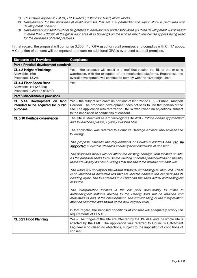
(former The Hills) Local Environmental Plan 2012.
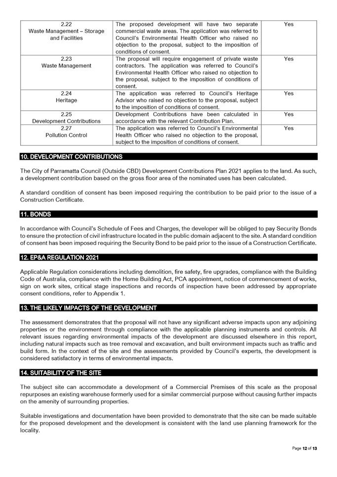
The application
was referred to a number of internal and external stakeholders, including the
following:
1. Catchment
Engineer
2. Landscape
Officer
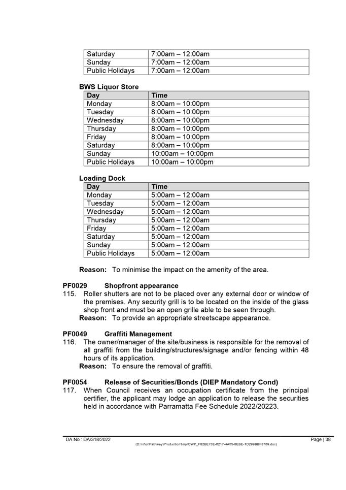
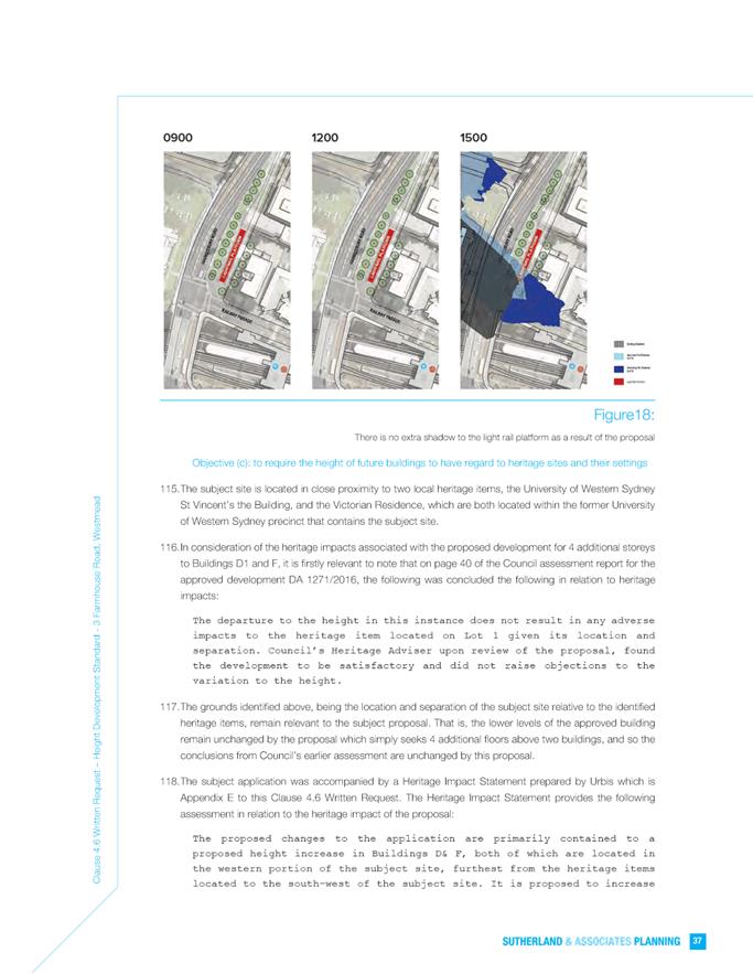
3. Traffic
Officer
4. Environmental
Health Officer
5. Heritage
Officer
6. Open
Space and Natural Resources
7. Accessibility
Officer
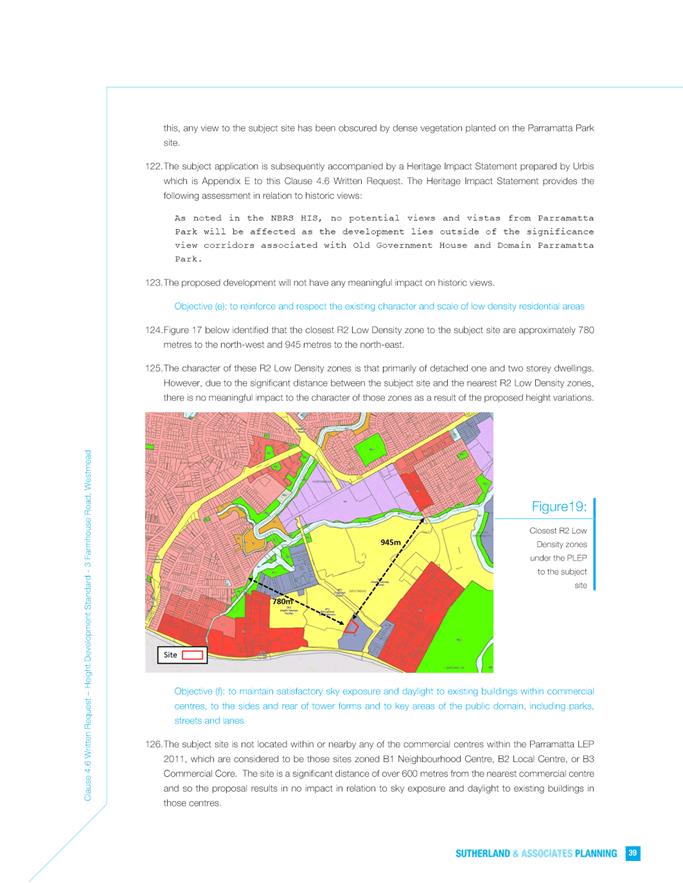
8. Crim
Prevention Officer
9. NSW
Police
10. Environment
Protection Authority
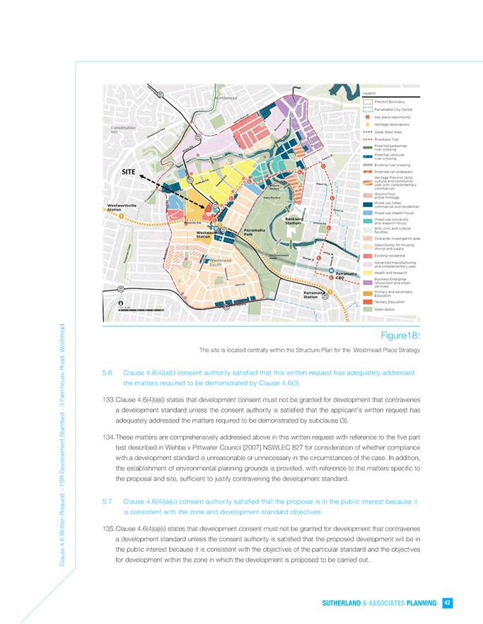
11. Natural
Resources Access Regulator
12. AMPOL
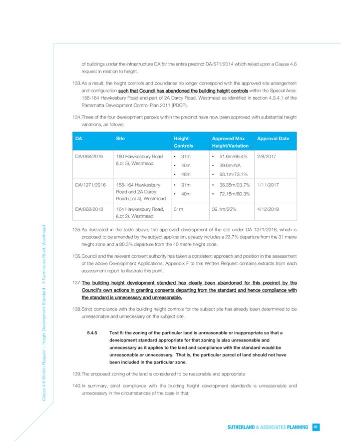
13. Endeavour
Energy
14. Transport
for NSW
All referrals
were returned with no objections raised, subject to the imposition of
conditions of consent.
The proposal is
not considered to have any other impacts to the surrounding amenity of the
locality.
Having regard to
the matters for consideration under Section 4.15 of the Environmental
Planning and Assessment Act 1979, it is recommended Development Application
DA/318/2022 be approved.
RECOMMENDATION
(a) That the Parramatta Local
Planning Panel, exercising the function of the consent authority, approve
development consent to DA/318/2022 for the ‘Construction of a
commercial retail development comprising of a Woolworths supermarket, BWS
liquor store, Direct to Boot distribution centre, gymnasium, and three (3)
retail premises and associated car parking, landscaping, and business
identification signage. The building is identified as a local heritage item A23
pursuant to THLEP 2012. Integrated development under Water Management Act 2000.
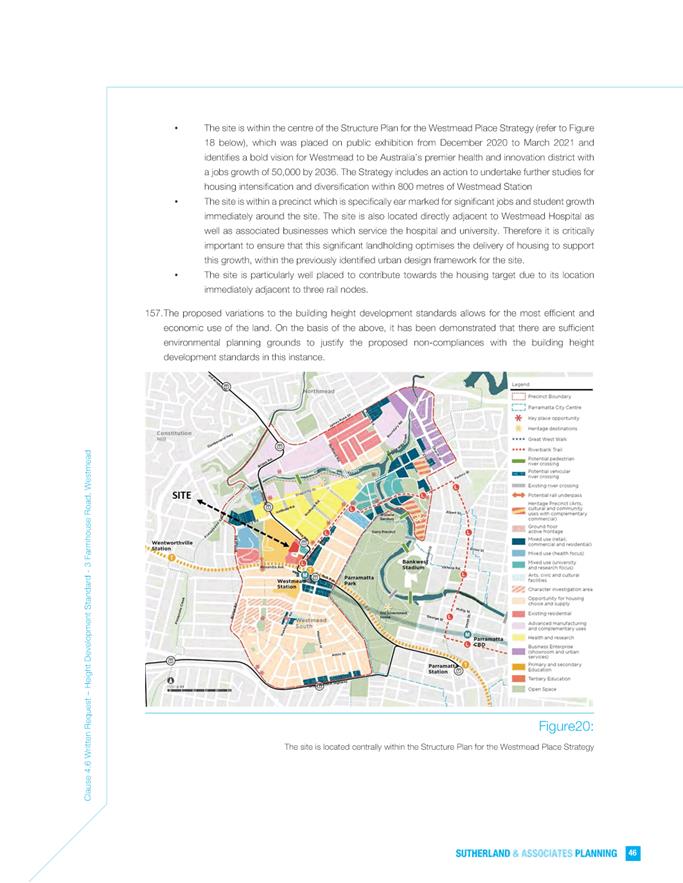
Installation of 20 signage types to include business
identification/advertising/ direction/ safety and other’ on land at 1 Windsor Road, North Rocks. The recommended conditions of consent
are within Attachment 1.
REASONS FOR APPROVAL
1. The development is permissible in the B6
Enterprise Corridor zone pursuant to Parramatta (former The Hills) Local
Environmental Plan 2012 and generally satisfies the requirements of the
applicable planning framework.
2. The
development will be compatible with the emerging and planned future character
of the area.
3. The
development will promote a business along a main road and encourages a mix of
compatible uses.
4. The
proposal provides a range of employment opportunities.
5. The
amenity impacts can be appropriately managed.
6. The
development is in the public interest because it is consistent with the
objectives of for development in the B6 Enterprise Corridor zone.
7. For
the reasons given above, approval of the application is in the public interest.
Darren Wan
Senior Development Assessment Officer
Sarah Irani
Team Leader Development Support
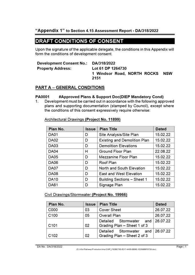
Attachments:
|
1⇩ 
|
Assessment Report and Draft Conditions
|
54 Pages
|
|
|
2⇩
|
Locality Map
|
1 Page
|
|
|
3⇩
|
Plans used for assessment
|
10 Pages
|
|
|
4⇩
|
Statement of Environmental Effects
|
57 Pages
|
|
|
5⇩
|
Voluntary Planning Agreements
|
81 Pages
|
|
|
6⇩
|
VPA Explanatory Note
|
4 Pages
|
|
REFERENCE MATERIAL
|
Item 5.1 - Attachment
1
|
Assessment Report and Draft Conditions
|
|
Item 5.1 - Attachment 2
|
Locality Map
|
|
Item 5.1 - Attachment
3
|
Plans used for assessment
|
|
Item 5.1 - Attachment 4
|
Statement of Environmental Effects
|


|
Item 5.1 - Attachment 5
|
Voluntary Planning Agreements
|
|
Item 5.1 - Attachment 6
|
VPA Explanatory Note
|
Local
Planning Panel 20 December 2022 Item
5.2
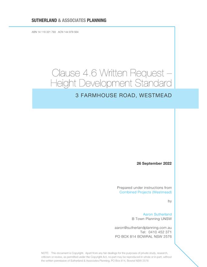
ITEM NUMBER 5.2
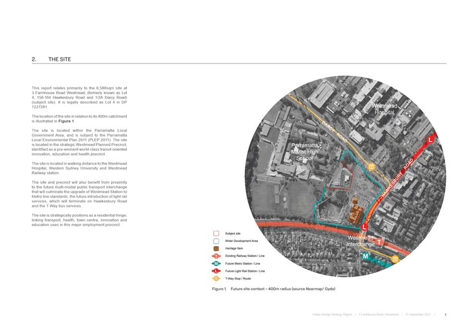
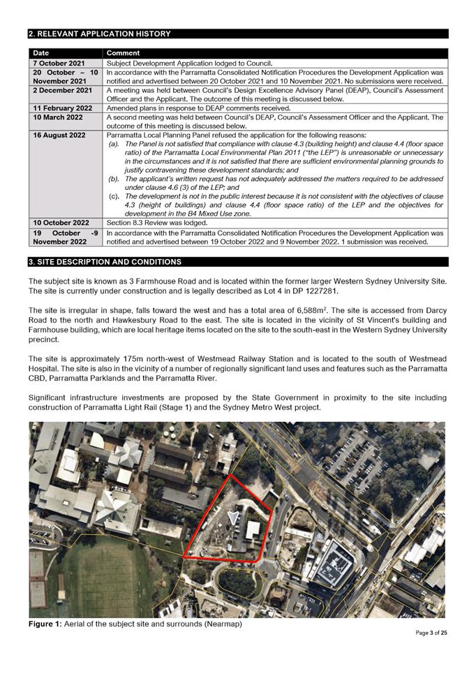
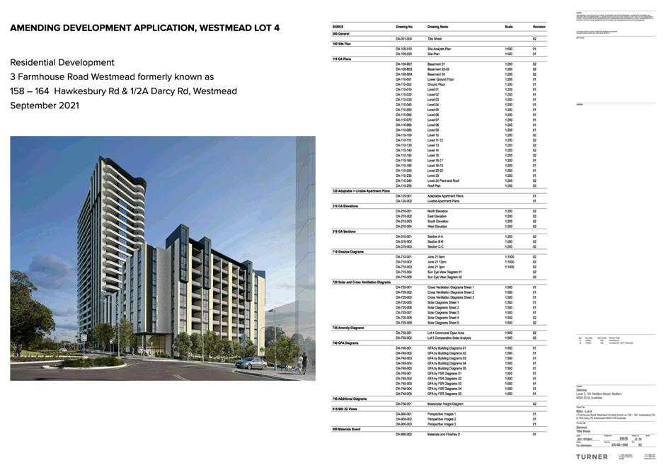
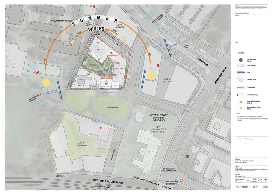
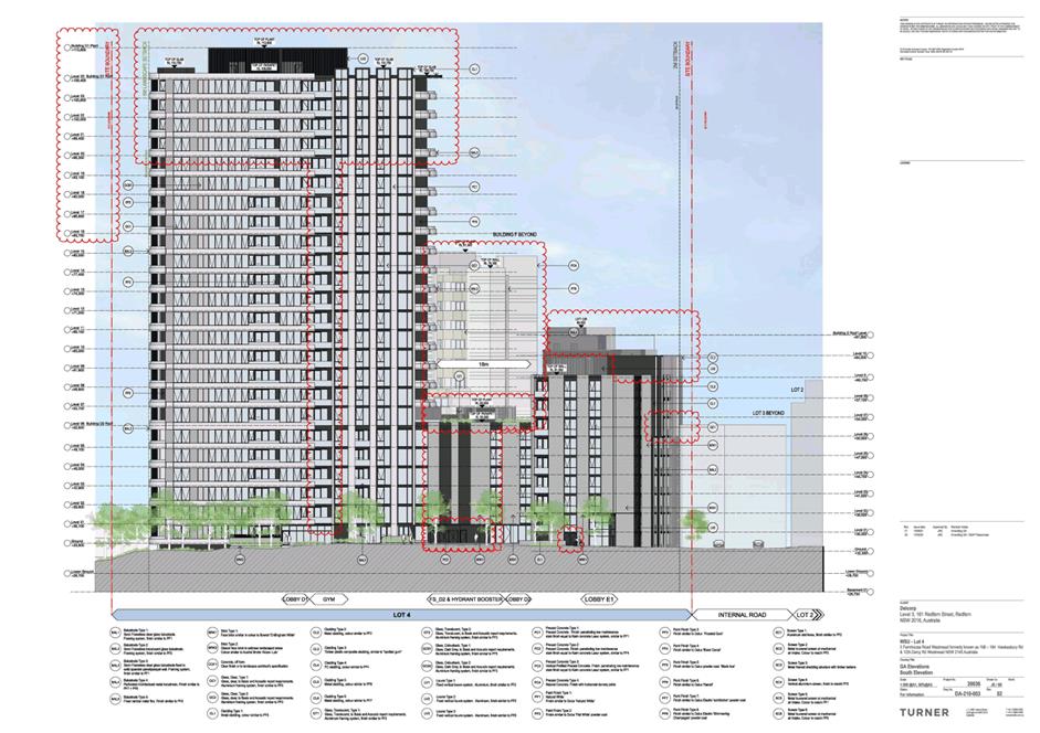
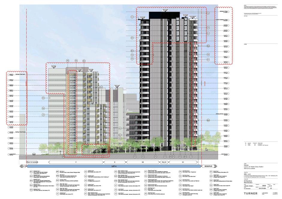
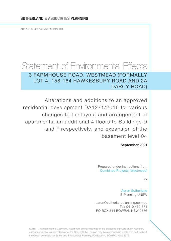
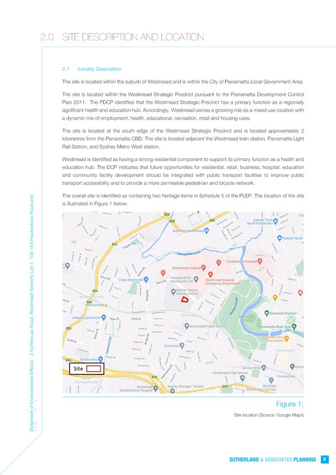
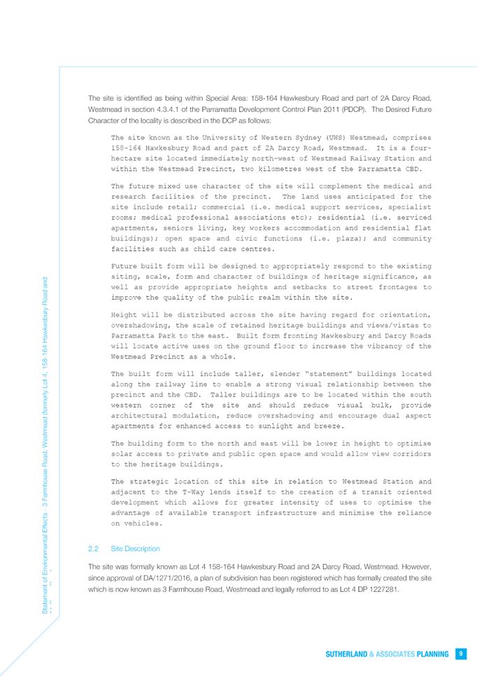
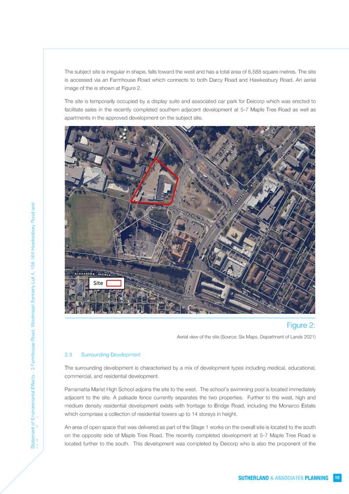
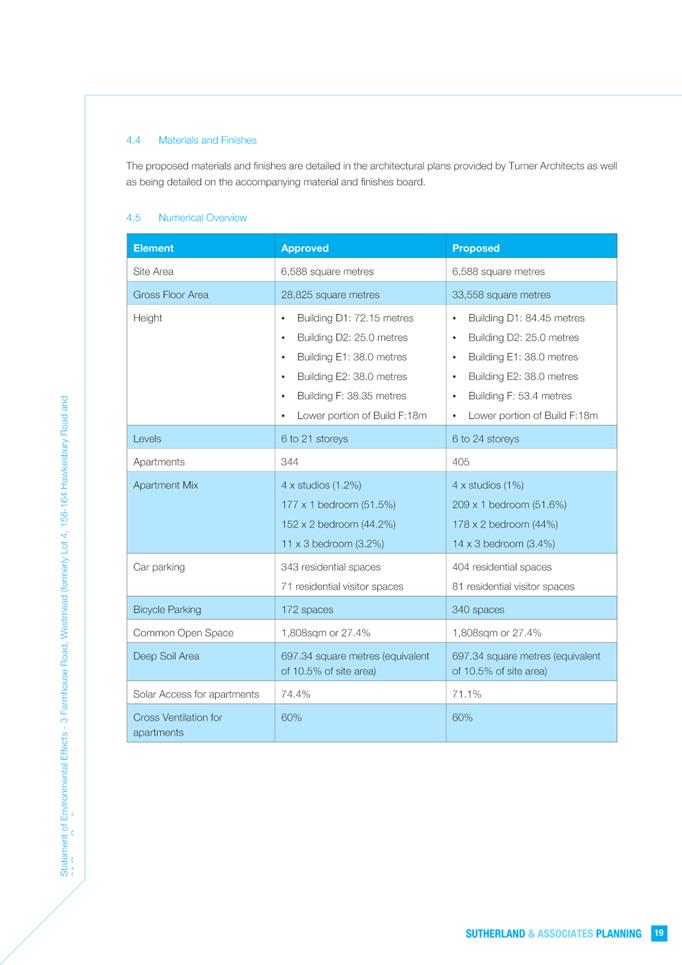
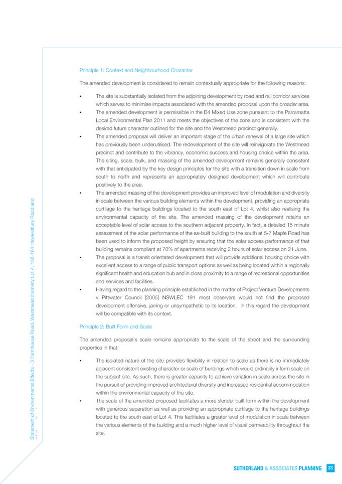
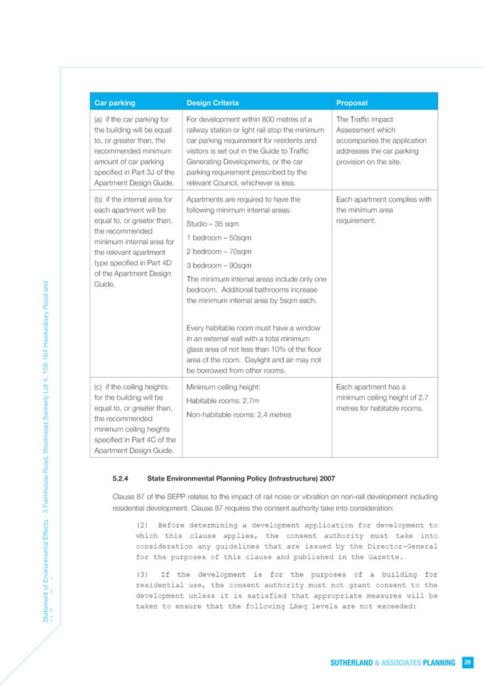
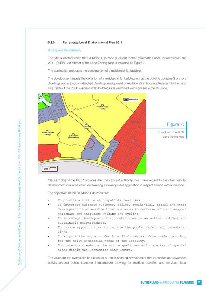
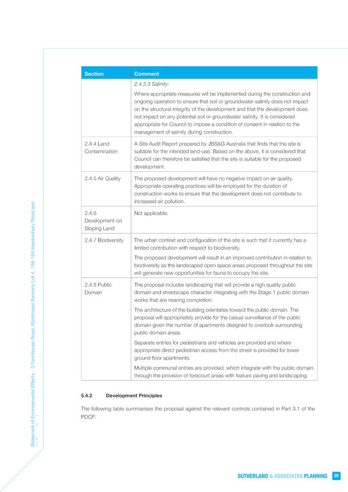
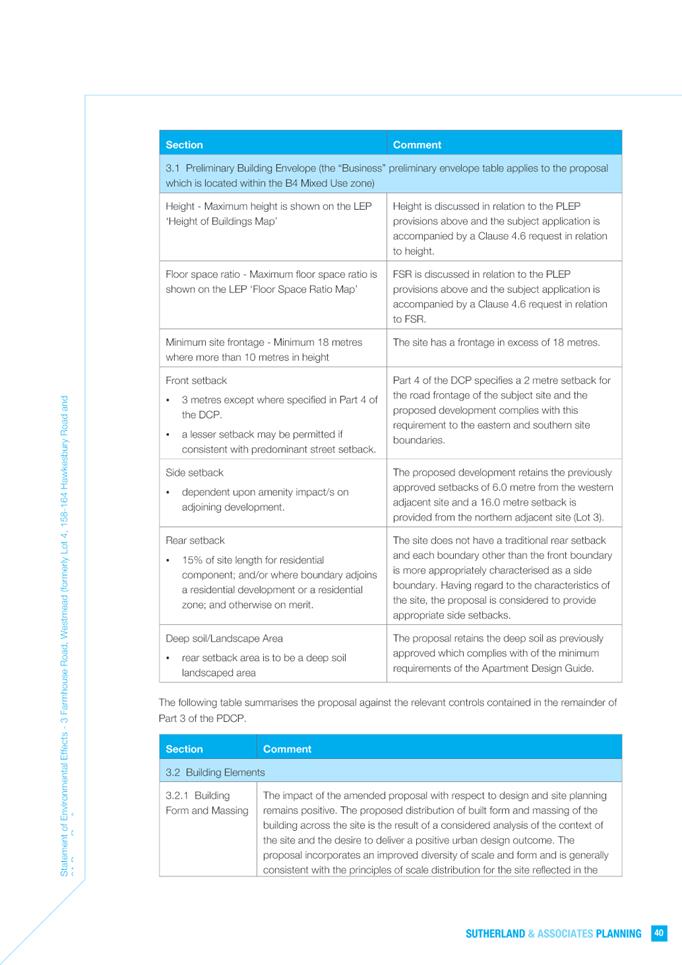
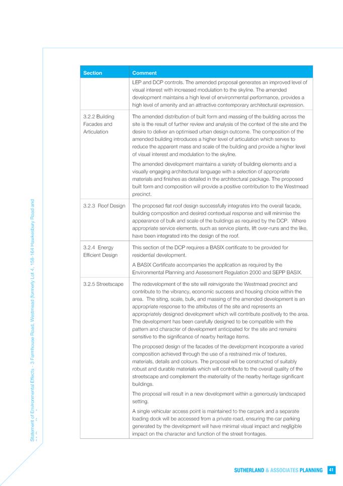
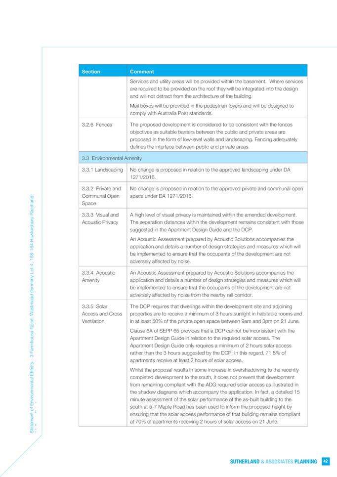
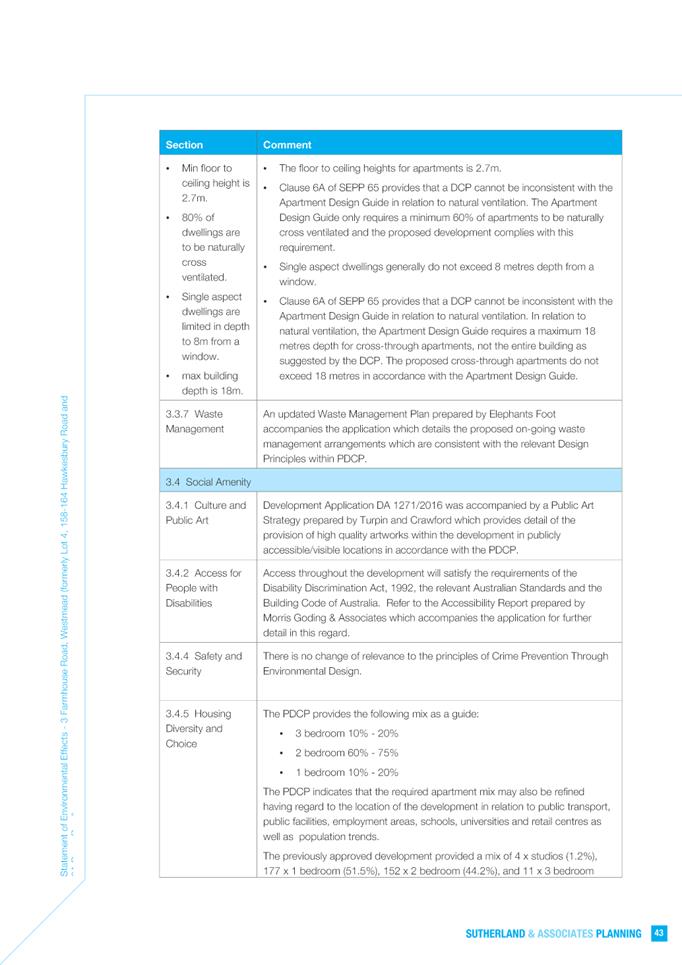
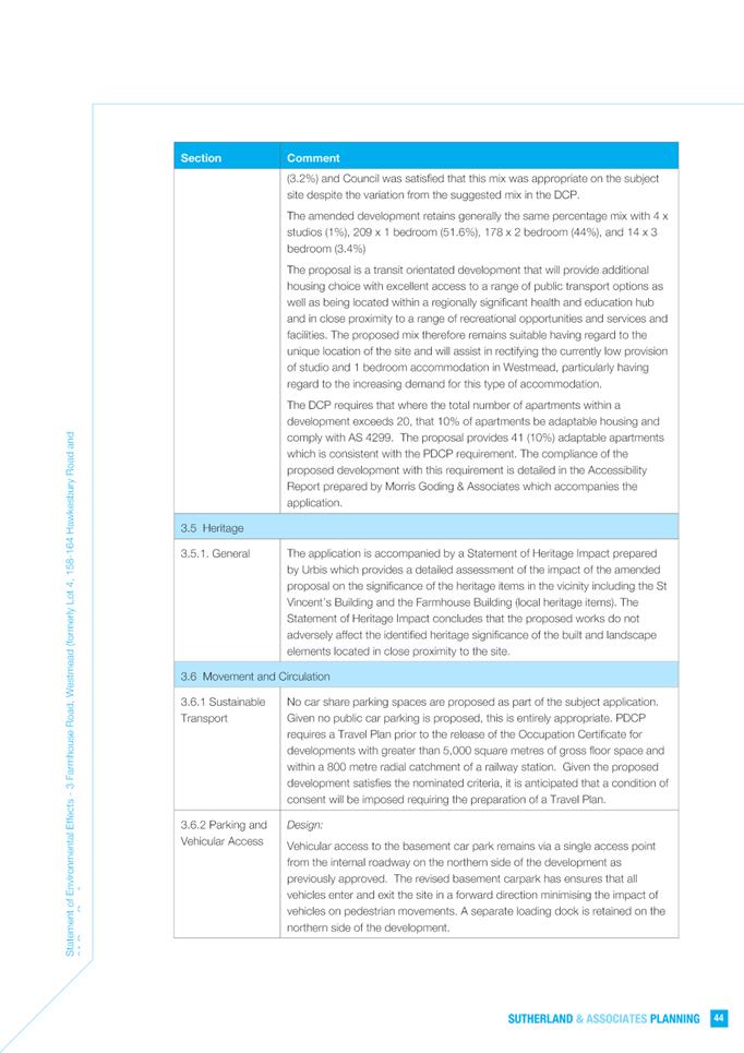
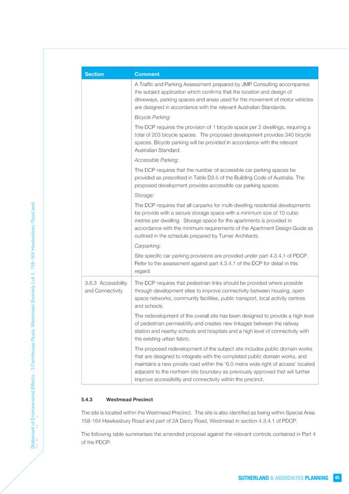
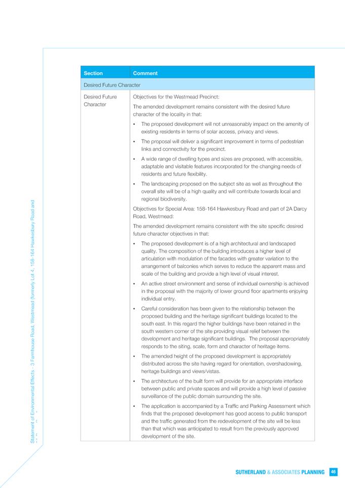
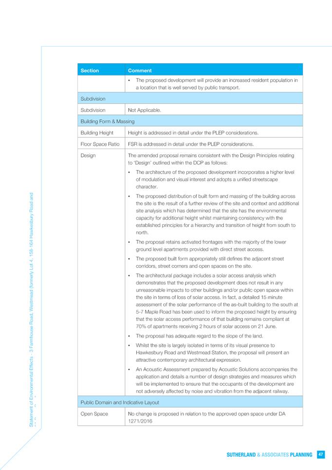
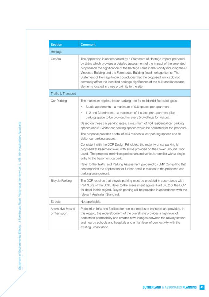
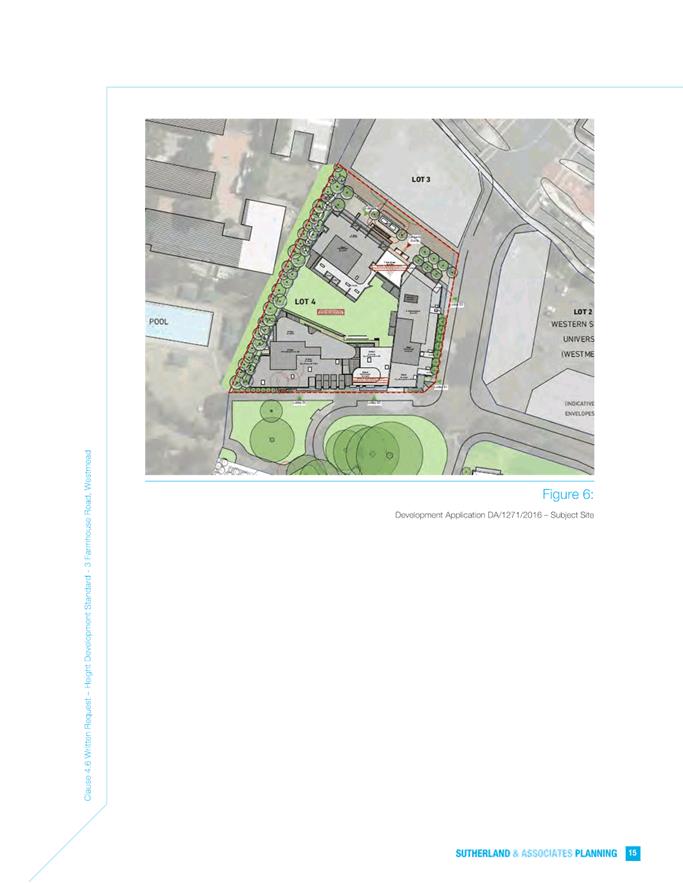
SUBJECT OUTSIDE PUBLIC MEETING: 3 Farmhouse Road, WESTMEAD, NSW, 2145 (Lot 4
in DP 1227281)
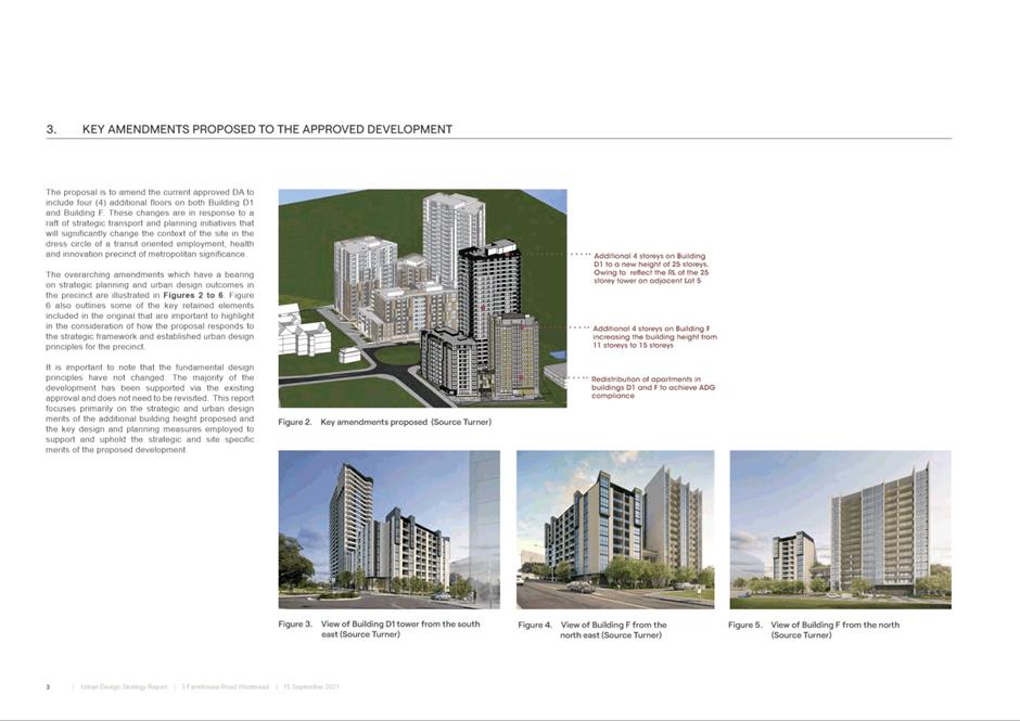
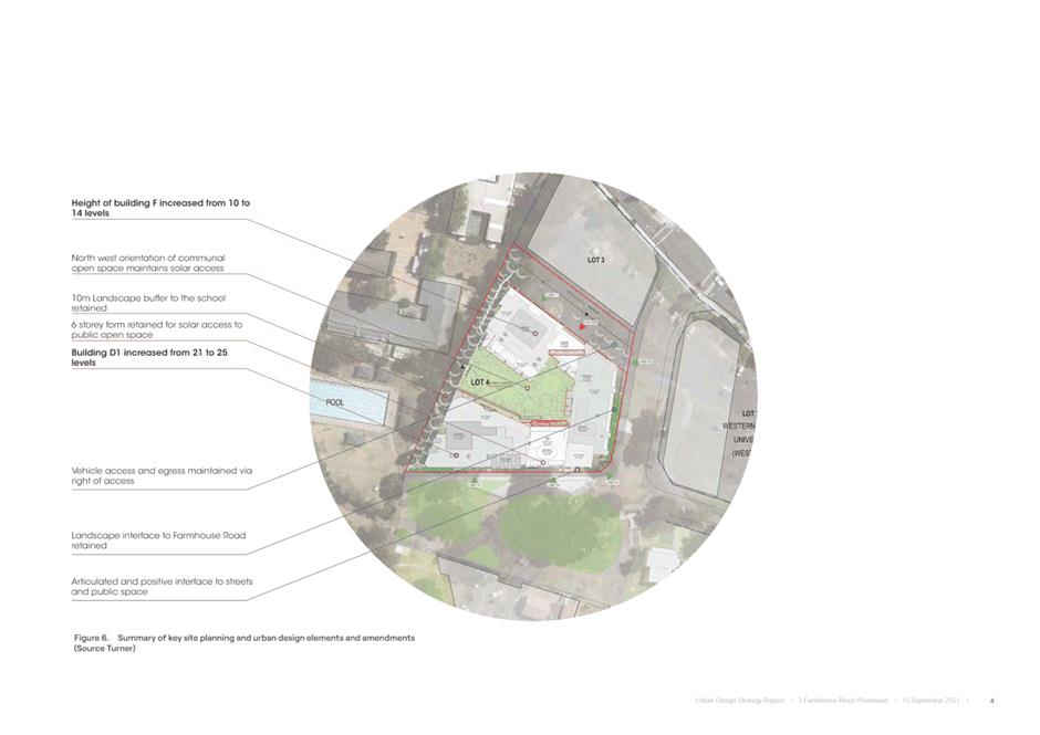
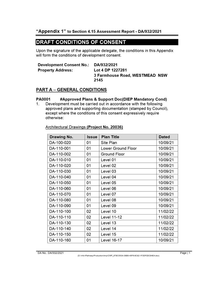
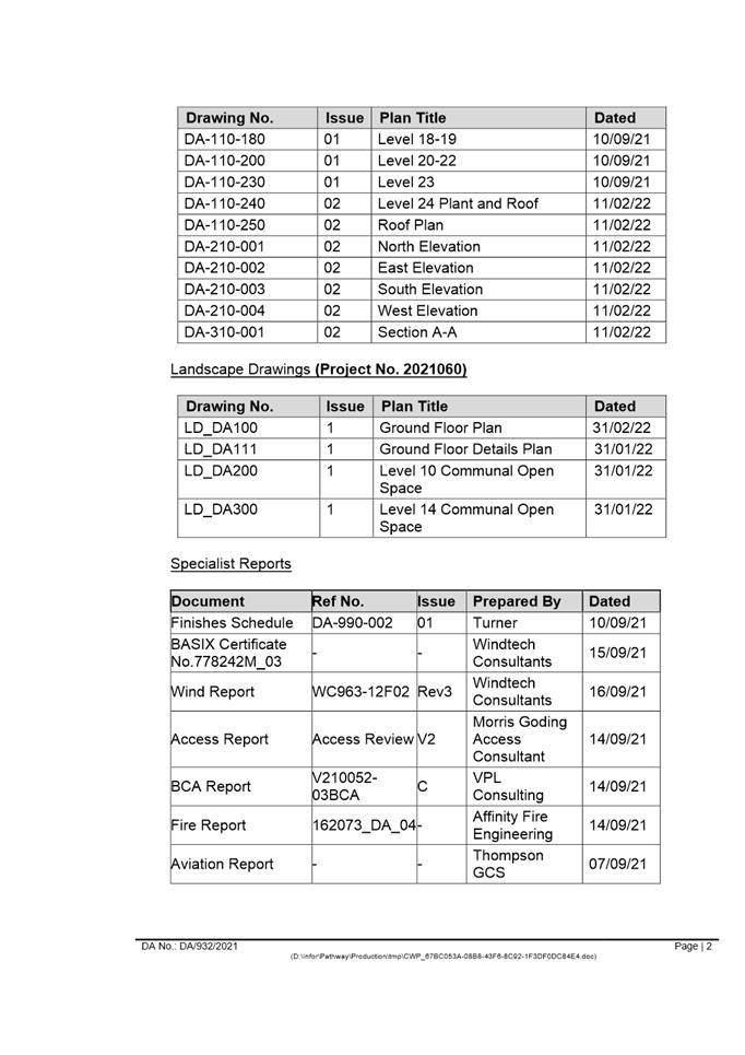
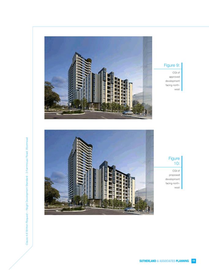
DESCRIPTION Section 8.3 Review of determination of DA/932/2021 for alterations
and additions to the approved residential development including an additional 4
floors to Buildings D and F and internal and external facade changes.
REFERENCE DA/932/2021 - D08781794
APPLICANT/S Combined Projects Westmead Pty Ltd
OWNERS Combined Projects (Westmead) Pty Ltd
REPORT OF Group
Manager Development and Traffic Services
RECOMMENDED Approval
DATE OF REPORT 30 November 2022
REASON FOR
REFERRAL TO LPP
This review of DA/932/2021 is being reported to the
Parramatta Local Planning Panel as a result of the variations sought to the
Building Height and FSR development standards under Clause 4.6 of the
Parramatta Local Environmental Plan 2011.
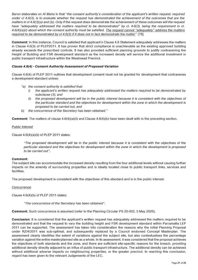
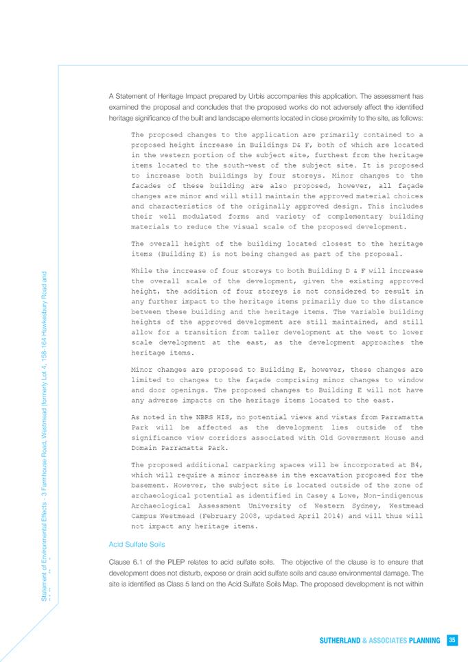
EXECUTIVE SUMMARY
Development Application DA/932/2021 was originally lodged on
7 October 2021 for ‘alterations and additions to the approved
residential development including an additional 4 floors to Buildings D and F,
expansion of basement 4 and internal and external facade changes’.
The application was refused by Parramatta Local Planning
Panel on 16 August 2022 for the following reasons:
(a). The Panel is not
satisfied that compliance with clause 4.3 (building height) and clause 4.4
(floor space ratio) of the Parramatta Local Environmental Plan 2011 (“the
LEP”) is unreasonable or unnecessary in the circumstances and it is not
satisfied that there are sufficient environmental planning grounds to justify
contravening these development standards; and
(b). The applicant’s written request has not adequately
addressed the matters required to be addressed under clause 4.6 (3) of the LEP;
and
(c). The
development is not in the public interest
because it is not consistent with the objectives of clause 4.3 (height of
buildings) and clause 4.4 (floor space ratio) of the LEP and the objectives for
development in the B4 Mixed Use zone.
This Section 8.3 Review was lodged on 10 October 2022 and
was accompanied by additional revised documentation to justify the Clause 4.6
variation. The only design change between the original application and this
review is the applicant no longer seeks additional car parking at the advice of
Council.
The Section 8.3 Review documents were re-advertised on 19 October 2022 and 9 November 2022, with
1 submission being received. The issues raised in that submission comprise:
1. Additional public transport not a valid
reason for non-compliance with the controls;
2. View loss to the north;
3. Submitter was assured that the building
heights on Lot 4 were fixed and would not increase;
4. Loss of privacy;
5. Overshadowing of the buildings and common
areas on Lot 5;
6. Additional units without additional
parking would cause additional traffic congestion.
In accordance
with the Section 8.3(5) of the Environmental Planning and Assessment Act
1979, this application is reported to the Parramatta Local Planning Panel
and must be determined within 6 months of the original determination date,
which is 16 February 2023.
Section
4.15 Assessment Summary
The
application has been assessed relative to section 4.15 of the Environmental
Planning and Assessment Act 1979, taking into consideration all relevant
state and local planning controls.
The
proposed development is for an additional four storeys to a residential flat
building that has already been approved with variations to the building height
and FSR development standards. The variations were informed by a Council
endorsed Concept Masterplan that sought to set a reasonable density for the
masterplanned site following a Planning Proposal that did not factor in
required roads and infrastructure. The Concept Masterplan varied the
development standards of the Planning proposal and set a preferred density of
122,995m2, distributed between 5 lots within the site.
When assessed against the development standards prescribed
by the Planning Proposal, the proposed additional four storeys result in a
development that exceeds the maximum permissible building height by 111.25% for
Building D, 72.25% for Building F, and exceeds the maximum permissible FSR by
69% for the 4:1 portion of the site. However, when
assessed against the preferred density of the Concept Masterplan, the
additional storeys result in a 4.3% increase to the total GFA.
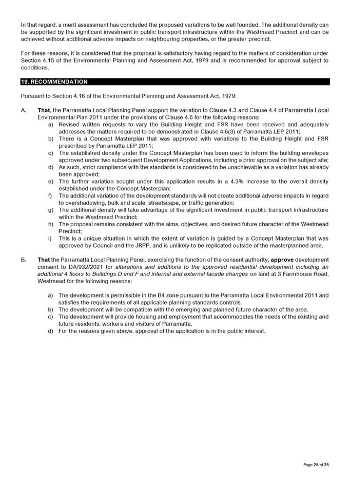
In
that regard, a merit assessment has concluded the proposed variations to be
well founded. The additional density can be supported by the significant
investment in public transport infrastructure within the Westmead Precinct and
can be achieved without additional adverse impacts on neighbouring properties,
or the greater precinct.
The
original application was referred to a number of internal and external
stakeholders for comment. No objections to the overall development were
received. Conditions of consent have been imposed where necessary.
Having regard to
the matters for consideration under Section 4.15 of the Environmental Planning
and Assessment Act, it is recommended Development Application DA/932/2021 be
approved.
RECOMMENDATION
(a) That,
the Parramatta Local Planning Panel support the variation to Clause 4.3 and
Clause 4.4 of Parramatta Local Environmental Plan 2011 under the
provisions of Clause 4.6 for the following reasons:
1. Revised written requests to vary the Building Height and
FSR have been received and adequately addresses the matters required to be
demonstrated in Clause 4.6(3) of Parramatta LEP 2011;
2. There is a Concept Masterplan that was approved with
variations to the Building Height and FSR prescribed by Parramatta LEP 2011;
3. The established density under the Concept Masterplan has
been used to inform the building envelopes approved under two subsequent
Development Applications, including a prior approval on the subject site;
4. As such, strict compliance with the standards is considered
to be unachievable as a variation has already been approved;
5. The further variation sought under this application results
in a 4.3% increase to the overall density established under the Concept
Masterplan;
6. The additional variation of the development standards will not
create additional adverse impacts in regard to overshadowing, bulk and scale,
streetscape, or traffic generation;
7. The additional density will take advantage of the significant
investment in public transport infrastructure within the Westmead Precinct;
8. The proposal remains consistent with the aims, objectives, and
desired future character of the Westmead Precinct;
9. This is a unique situation in which the extent of variation is
guided by a Concept Masterplan that was approved by Council and the JRPP, and
is unlikely to be replicated outside of the master planned area.
(b) That
the Parramatta Local Planning Panel, exercising the
function of the consent authority, approve development consent to
DA/932/2021 for alterations and additions to the approved residential
development including an additional 4 floors to Buildings D and F and internal
and external facade changes on
land at 3 Farmhouse Road, Westmead. The recommended
conditions of consent are within Attachment 1.
(c) Further, that submitters are advised of the decision.
REASONS FOR APPROVAL
1. The
development is permissible in the B4 zone pursuant to the Parramatta Local
Environmental 2011 and satisfies the requirements of all applicable planning
standards controls.
2. The
development will be compatible with the emerging and planned future character
of the area.
3. The
development will provide housing and employment that accommodates the needs of
the existing and future residents, workers and visitors of Parramatta.
4. For the
reasons given above, approval of the application is in the public interest.
Darren Wan
Senior Development Assessment Officer
Attachments:
|
1⇩ 
|
Assessment Report and Draft Conditions
|
41 Pages
|
|
|
2⇩
|
Locality Map
|
1 Page
|
|
|
3⇩
|
Architectural plans used for assessment
|
8 Pages
|
|
|
4
|
Architectural plans used for assessment
(confidential)
|
22 Pages
|
|
|
5⇩
|
Statement of Environmental Effects
|
53 Pages
|
|
|
6⇩
|
Clause 4.6 Variation Request - Building
Height
|
51 Pages
|
|
|
7⇩
|
Clause 4.6 Variation Request - FSR
|
66 Pages
|
|
|
8⇩
|
Memorandum of Opinion - 3 Farmhouse Road
Westmead
|
13 Pages
|
|
|
9
|
SC Legal Opinion - 3 Farmhouse Road,
Westmead (confidential)
|
10 Pages
|
|
REFERENCE MATERIAL
|
Item 5.2 - Attachment
1
|
Assessment Report and Draft Conditions
|
|
Item 5.2 - Attachment 2
|
Locality Map
|
|
Item 5.2 - Attachment
3
|
Architectural plans used for assessment
|
|
Item 5.2 - Attachment 5
|
Statement of Environmental Effects
|
|
Item 5.2 - Attachment 6
|
Clause 4.6 Variation Request - Building Height
|


|
Item 5.2 - Attachment 7
|
Clause 4.6 Variation Request - FSR
|


|
Item 5.2 - Attachment 8
|
Memorandum of Opinion - 3 Farmhouse Road Westmead
|
Local
Planning Panel 20 December 2022 Item
5.3
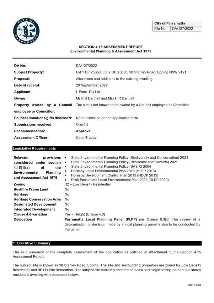
ITEM NUMBER 5.3
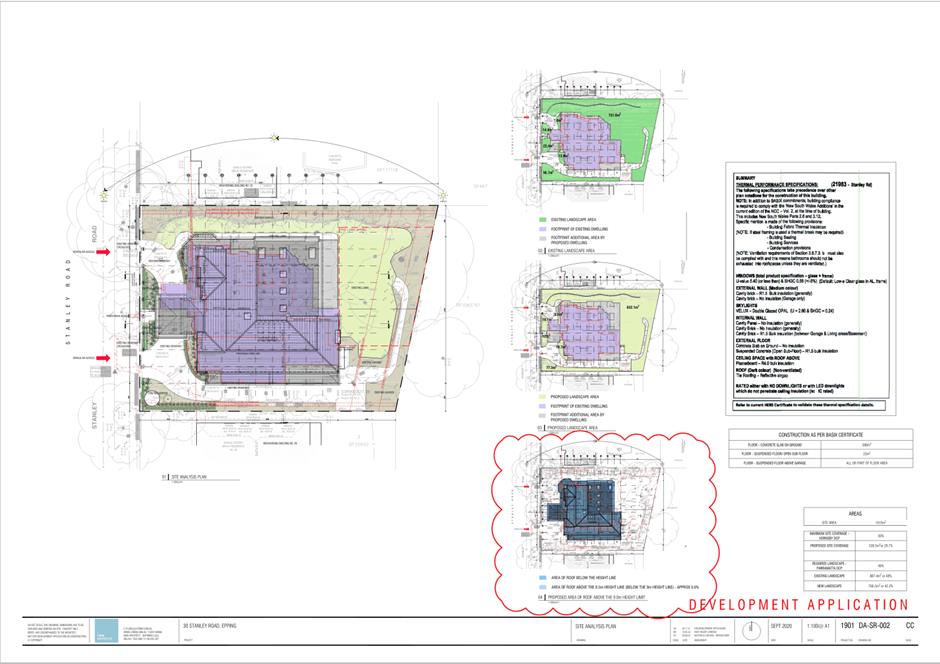
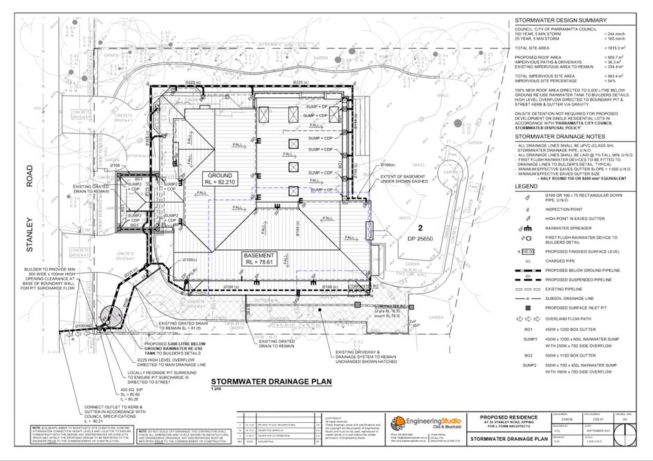
SUBJECT OUTSIDE PUBLIC MEETING: 30 Stanley Road, EPPING (Lot 1 DP 25650, Lot
2 DP 25650)
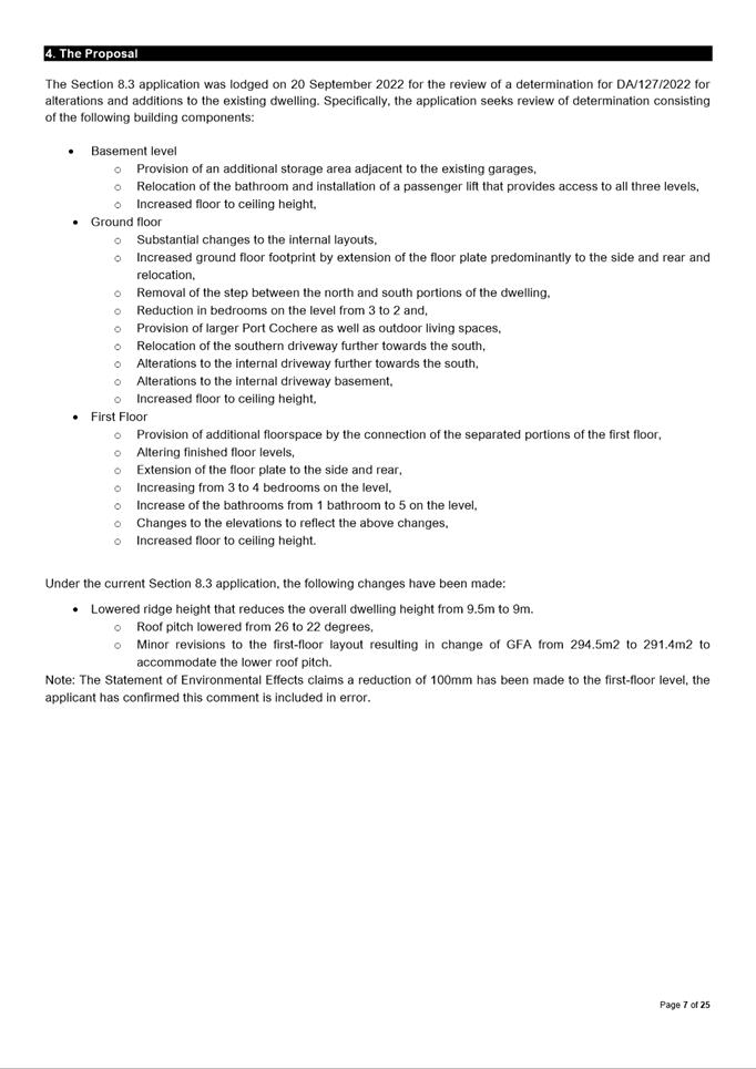
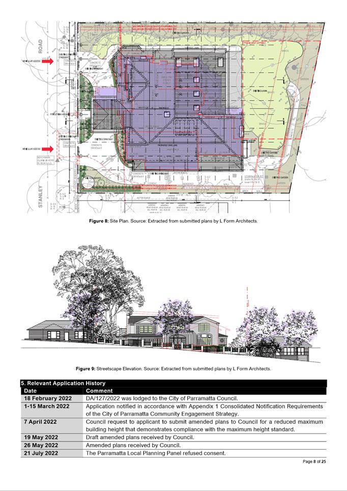
DESCRIPTION Section 8.3 review of a determination for DA/127/2022 for
alterations and additions to the dwelling house
REFERENCE DA/127/2022 - D08732061
APPLICANT/S Think Planners
OWNERS Mr R S Dartnall, Mrs H R Dartnell
REPORT OF Group
Manager Development and Traffic Services
RECOMMENDED Approval
DATE OF REPORT 5 december 2022
REASON
FOR REFERRAL TO LPP
The application which has been lodged per
clause 8.3 is being reported to the Parramatta Local Planning Panel as the
application consists of the review of a determination previously made by the
Parramatta Local Planning Panel.
EXECUTIVE SUMMARY
This
is a summary of the complete assessment of the application as outlined in
Attachment 1, the Section 4.15 Assessment Report.
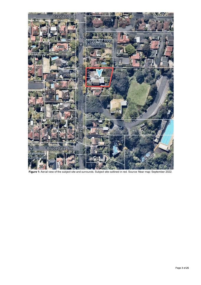
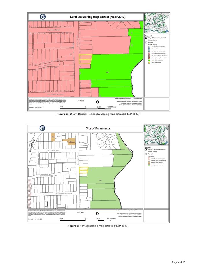
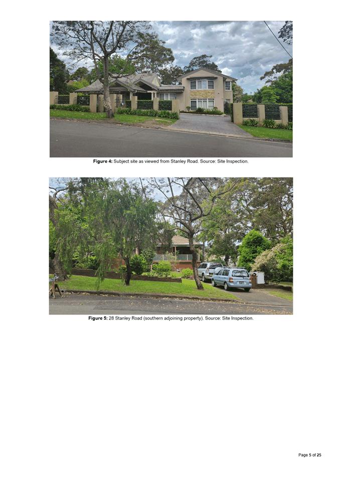
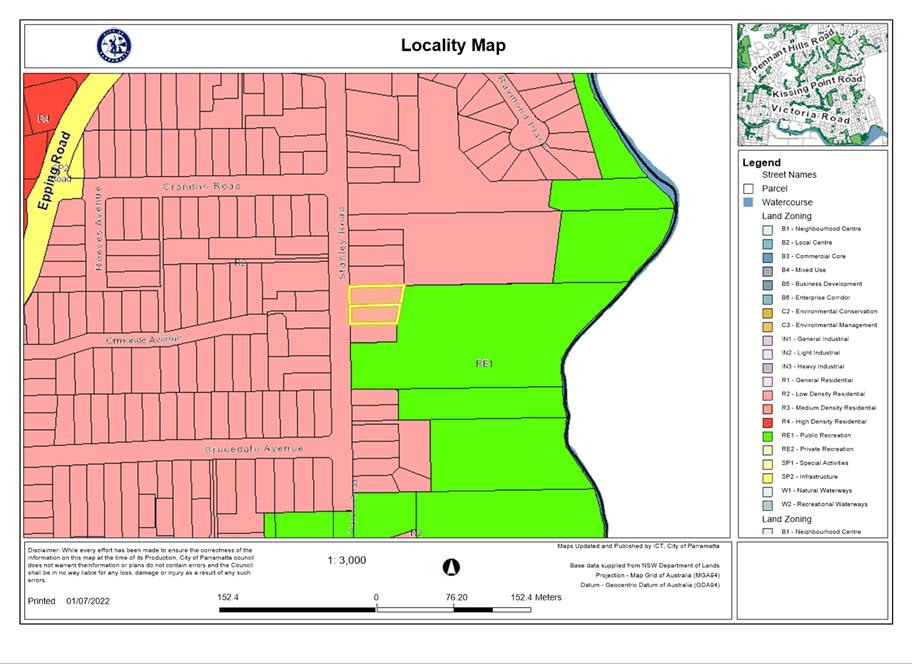
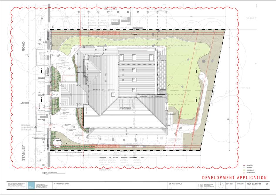
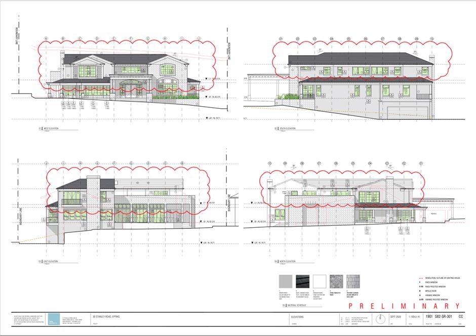
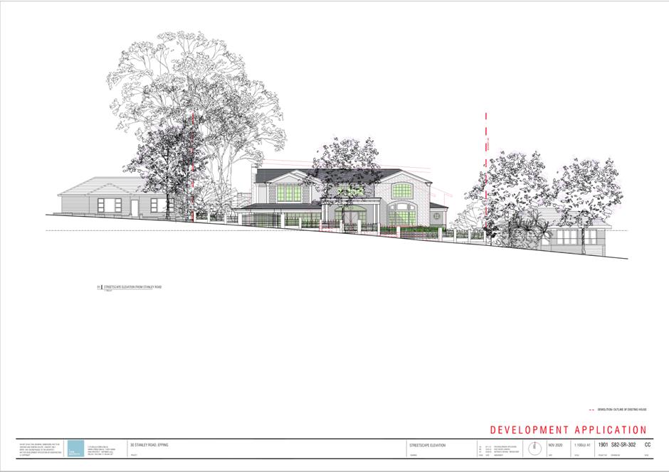
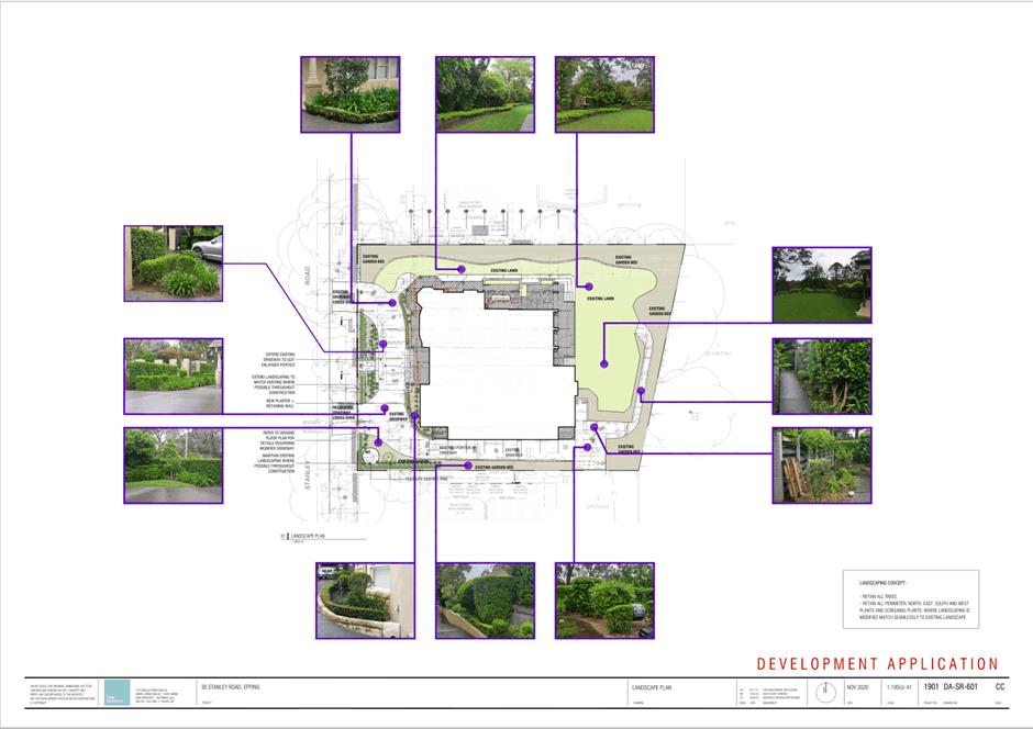
The subject site is known as 30 Stanley
Road, Epping. The site and surrounding properties are zoned R2 Low Density
Residential and RE1 Public Recreation.
The subject site currently accommodates a part single storey, part double storey residential dwelling with
basement below.
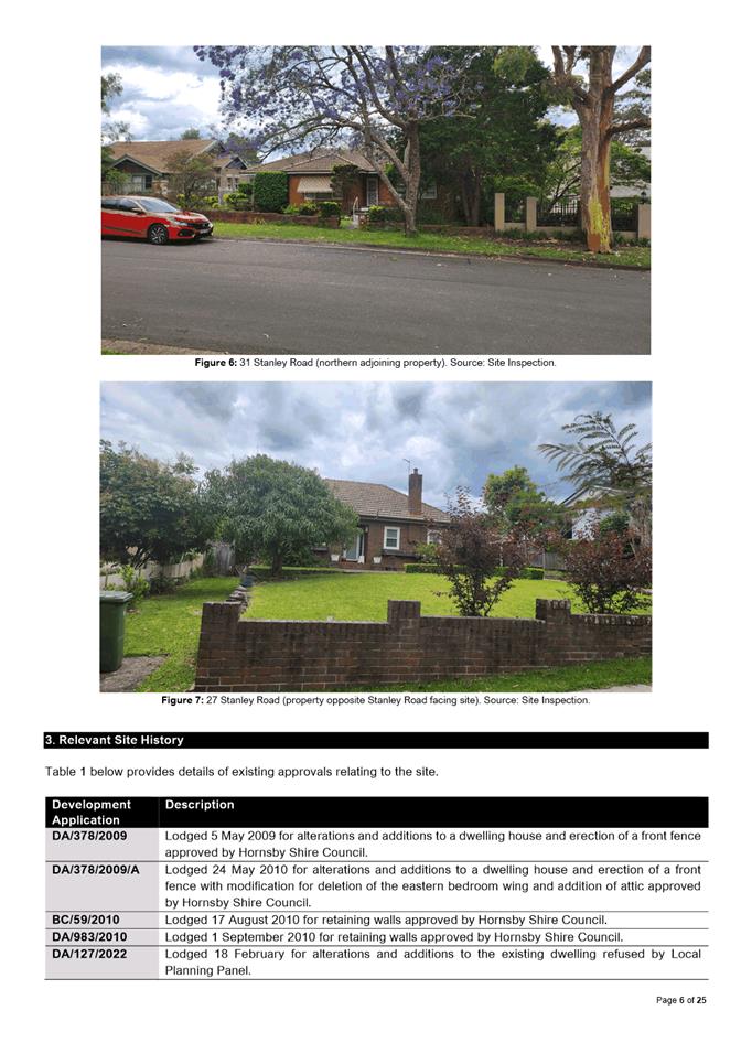
The site is located within an established
residential area characterised by single and double storey residential
dwellings. Adjoining the subject site to the sides (north and south) are single
storey residential dwellings. The rear of the site adjoins Dence Park which is
identified as a landscape heritage item of local significance.
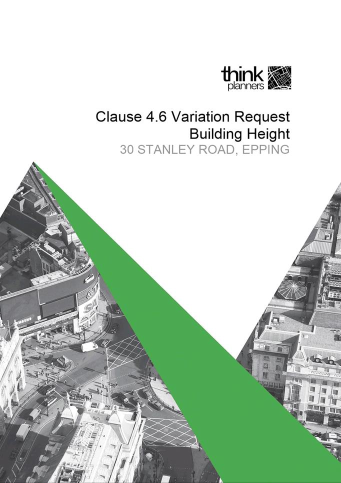
The proposed development for alterations
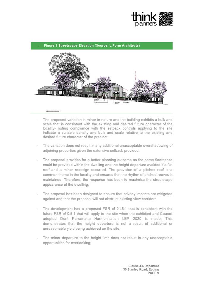
and additions to the existing dwelling includes a variation to Clause 4.3
Height of Buildings of the Hornsby Local Environmental Plan 2013. The
extent of variation in this instance is limited to a minor portion of the
proposed dwelling due to the use of sensible design measures that reduce visual
impact to a level that allows the proposal to reasonably align with the
objectives of clause 4.3. The proposal also makes effort to comfortably reflect
the context of the site in which it is located and enables reasonable
consideration for existing site constraints that concern topography. Due to the
unique context and scale of the site and the negligible visual impacts as a
result of the proposal, it would be considered unnecessary to enforce numerical
compliance. Therefore, Council is satisfied the variation to the control is
reasonable in this instance.
RECOMMENDATION
(a) That, the Parramatta Local Planning Panel support the variation to
Clause 4.3 of Hornsby Local Environmental Plan 2013 under the
provisions of Clause 4.6 for the following reasons:
1. That
compliance with the development standard for height would be unnecessary upon
reflection of the unique context and scale of the site and natural constraints
present and,
2. That the
proposed non compliance will result in negligible visual impact to adjoining
properties and the streetscape and,
3. That the
proposed non compliance will result in negligible impact to bulk and scale as
the proposed non compliance is minor and restricted to insignificant portions
of the proposed dwelling.
(b) That the Parramatta Local Planning Panel, exercising the function of the
consent authority, approve development consent to DA/127/2022 for the
alteration and additions to the existing dwelling on land at 30 Stanley Road, Epping, subject to the conditions of
consent in Attachment 1.
(c) Further, that submitters be advised of the Panel’s decision.
REASONS FOR
APPROVAL
1. The development is
permissible in the R2 zone pursuant to the Hornsby Local Environmental plan
2013 and satisfies the requirements of all applicable planning standards
controls.
2. The development will be
compatible with the emerging and planned future character of the area.
3. The development will
provide housing needs for the community within a low-density residential
environment.
4. For the reasons given
above, approval of the application is in the public interest.
Cade Tracey
Development Assessment Officer
Attachments:
|
1⇩ 
|
Assessment Report and Draft Conditions
|
41 Pages
|
|
|
2⇩
|
Locality Map
|
1 Page
|
|
|
3⇩
|
Plans used during Assessment
|
7 Pages
|
|
|
4
|
Internal Plans used during Assesssment
(confidential)
|
4 Pages
|
|
|
5⇩
|
Clause 4.6 Statement
|
11 Pages
|
|
REFERENCE MATERIAL
|
Item 5.3 - Attachment
1
|
Assessment Report and Draft Conditions
|
|
Item 5.3 - Attachment 2
|
Locality Map
|
|
Item 5.3 - Attachment
3
|
Plans used during Assessment
|
|
Item 5.3 - Attachment 5
|
Clause 4.6 Statement
|

Planning Proposals
20 December 2022
6.1 Post
Exhibition: Planning Proposal and Draft Planning Agreement for 263-273 &
279R Pennant Hills Road and 18 Shirley Street, Carlingford................. 518
Local Planning Panel 20 December 2022 Item
6.1
ITEM NUMBER 6.1
SUBJECT Post Exhibition: Planning Proposal and Draft Planning Agreement for
263-273 & 279R Pennant Hills Road and 18 Shirley Street, Carlingford.
REFERENCE RZ/4/2021 -
APPLICANT/S Karimbla Construction Services (NSW) Pty Ltd
OWNERS Karimbla Properties (No. 61) Pty Ltd
REPORT OF Project Officer Land Use
Development
applications considered by Sydney central city planning panel
Deferred Commencement Development Consent
No.1103/2011/JP issued by the Joint Regional Planning Panel for demolition of
existing structures and associated construction of five apartment buildings
9-11 storeys containing 450 units and basement parking for 662 cars (active
consent granted 21 July 2015).
Development Application 53/2022 for
construction of seven 10-13 storey buildings comprising 620 residential units,
child care centre for 110 children, 1,735sqm of 17 neighbourhood retail shops
and 864 basement car parking spaces; publicly accessible open spaces and
through site links; roads; landscaping; and tree removal. The application was
refused at 1 December 2022 Sydney Central City Planning Panel considered the
report.
PURPOSE
To seek the Local Planning Panel’s advice to Council
on the outcome of the public exhibition of the Planning Proposal and draft
Planning Agreement for land at 263-273 & 279R
Pennant Hills Road and 18 Shirley Street, Carlingford.
RECOMMENDATION
That the Local Planning Panel
support the following Council Officer recommendation in its advice to Council:
(a) That Council receive and note the
submissions (summarised in this report) made during the public exhibition of
the Planning Proposal and draft Planning Agreement for 263-273 & 279R
Pennant Hills Road and 18 Shirley Street, Carlingford.
(b) That Council approve the Planning
Proposal (Attachment 1) for land at 263 - 273 & 279R Pennant Hills
Road and 18 Shirley Street, Carlingford for finalisation that seeks to amend
the Parramatta (former The Hills) Local Environmental Plan 2012 as follows:
i. Amend Schedule 1 to permit ‘shops’ and ‘food and
drink premises’, ‘business premises’ and ‘recreational
facility (indoor)’ up to a combined total GFA of 2,000sqm on the R4 High
Density Residential zoned part of the site.
ii. Addition of the R4 High Density
Residential zoned part of the site to the Additional Permitted Uses Map to
facilitate retail floor space, neighbourhood supermarket along with specialty
retail, business, and recreational uses.
(c) That Council approve the Planning
Agreement at Attachment 2 and the Chief Executive Officer be delegated
authority to sign and execute the Planning Agreement on behalf of Council which
will deliver:
i. A shared walking/cycling pathway through
Council owned Shirley Street Reserve which forms part of the connection to the
Carlingford Light Rail stop; and
ii. A raised pedestrian crossing accommodating both
cyclists and pedestrians on Shirley Street.
(d) That Council delegate authority to the
Chief Executive Officer to exercise the plan making delegations as granted by
the Gateway Determination for this Planning Proposal.
(e) Further, that Council delegate authority
to the Chief Executive Officer to make any minor amendments and corrections of
a non-policy and administrative nature that may arise during the plan amendment
process relating to the Planning Proposal and
finalisation of the Planning Agreement.
SUMMARY
1. This report
seeks the advice of the Local Planning Panel (LPP) on the outcomes of the
public exhibition of a Planning Proposal and draft Planning Agreement for
263-273 & 279R Pennant Hills Road and 18 Shirley Street, Carlingford for
Council consideration.
2. The Planning
Proposal seeks to amend the Parramatta (formerly The Hills) Local Environmental
Plan (LEP) 2012 to amend Schedule 1 and amend the
Additional Permitted Uses Map to facilitate shops, food and drink premises,
business premises and recreational facility (indoor) on the R4 High Density
Residential part of site.
3. The Planning
Proposal, draft DCP and Planning Agreement were placed on public exhibition
from 12 October 2022 to 9 November 2022, with four (4) submissions received
comprising of three (3) from the community and one (1) agency submission from
Transport for NSW (TfNSW). A summary of the key issues raised in the
submissions is provided in this report. Overall, one (1) of the resident
submissions supported the proposal, one (1) partially supported the proposal
and one (1) objected to the proposal. The agency
submission from TfNSW neither stated objection or support.
BACKGROUND
4. In 2007 the
then Baulkham Hills Shire Council (now The Hills Shire Council) rezoned the
Carlingford Precinct to facilitate further growth in the Carlingford Precinct.
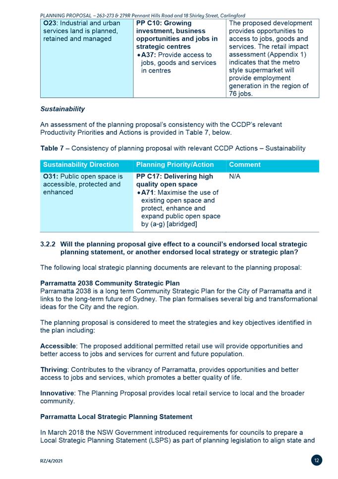
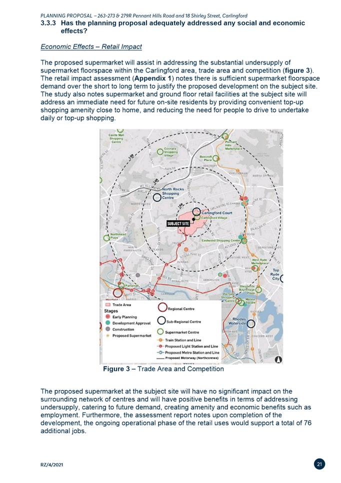
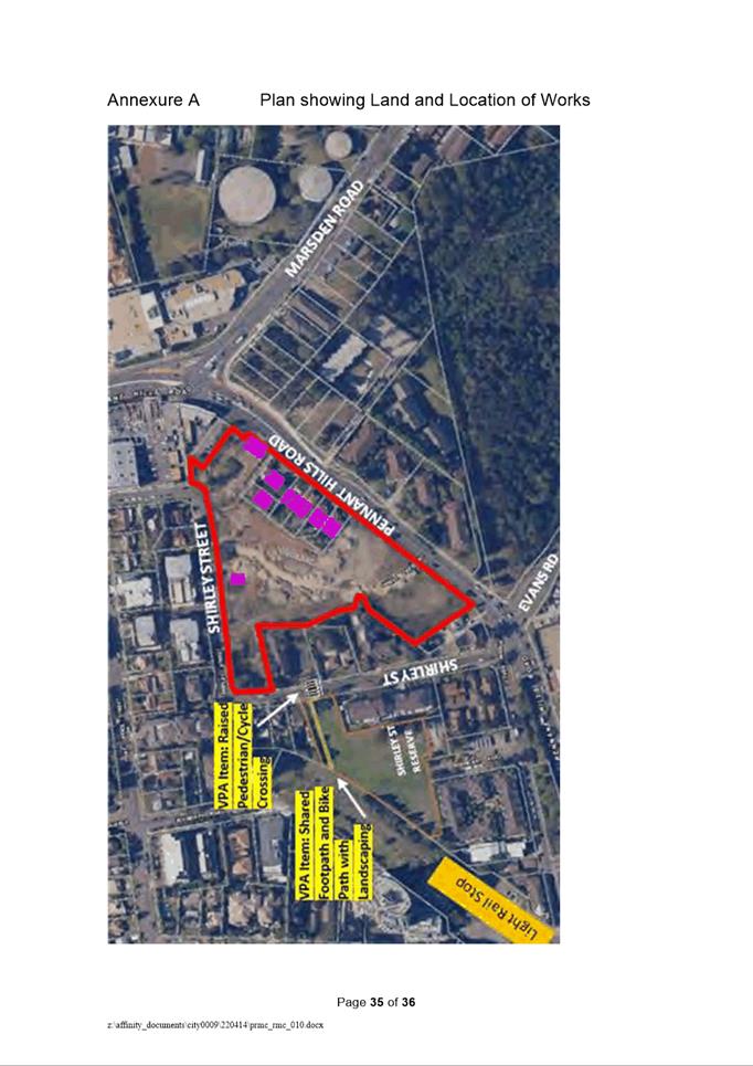
The subject site (Figures 1 & 2) is located within the Carlingford
Precinct.
5. The Joint
Regional Planning Panel granted development approval (DA1103/2011/JP) in April
2012 for the construction of five apartment buildings (9-11 storeys) containing
450 units and 662 basement parking spaces at 18 Shirley Street, Carlingford
which is part of the planning proposal subject site. The application was
subsequently activated by demolition and other early site works. Subsequent to
this approval, a further six properties at 263-273 Pennant Hills Road were
acquired by Karimbla Properties (No. 61) Pty Ltd.
6. Part of the
subject site (18 Shirley Street and 279R Pennant Hills Road) was previously
owned by Dyldam and was purchased in December 2020 by Karimbla Properties (No.
61) Pty Ltd (part of the Meriton Group). It is noted that the site is
already subject to a Planning Agreement relating to the dedication of land
zoned RE1 Public Recreation to Council. This is further detailed in the
Planning Agreement section of this report.
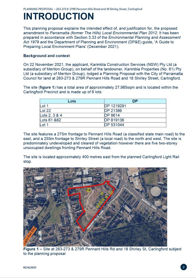
7. On 22 November 2021, the applicant,
Karimbla Construction Services (NSW) Pty Ltd, on behalf of the landowner,
Karimbla Properties (No. 61) Pty Ltd, lodged a Planning Proposal with the City
of Parramatta Council for land at 263-273 & 279R Pennant Hills Road and 18
Shirley Street, Carlingford. The objective of the subject Planning Proposal is
to facilitate additional permitted uses of up to 2,000sqm of
‘shops’ and ‘food and drink premises’ along with
‘business premises’ and ‘recreational facility (indoor)’
on the R4 High Density Residential part of the site.
8. In December 2021 the applicant
lodged a development application (DA/53/2022) for the construction of six
buildings up to 12 storeys in height, containing 629 residential apartments, a
childcare facility and neighbourhood shops on the larger set of properties
acquired by the current owner. It is noted that the additional land uses sought
under the subject Planning Proposal are not included within the current
development application. The development application was considered by the
Sydney Central City Planning Panel on 1 December 2022. The decision of the
Panel was to refuse the application.
9. On 17 May 2022, the Local Planning
Panel provided advice to Council recommending it endorse this Planning Proposal
for the purpose of requesting a Gateway Determination to amend Schedule 1 and
amend the Additional Permitted Uses Map to facilitate shops, food and drink
premises, business premises and recreational facility (indoor) on the site up
to 2,000sqm on the R4 High Density Residential Part of the site.
10. At its meeting on 14 June 2022, Council
resolved to endorse the Planning Proposal for the purpose of requesting a
Gateway Determination and to amend Schedule 1 and amend the Additional
Permitted Uses Map consistent with the recommendation of the Local Planning
Panel. Council also resolved to prepare a draft Planning Agreement to be
exhibited with the Planning Proposal. A more detailed summary of the Planning
Proposal is provided later in this report.
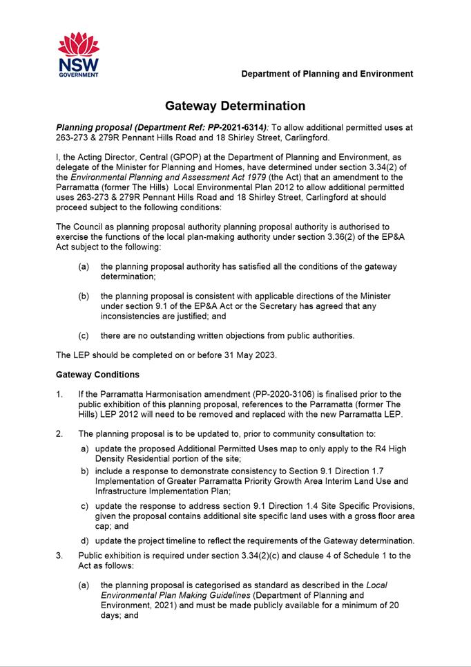
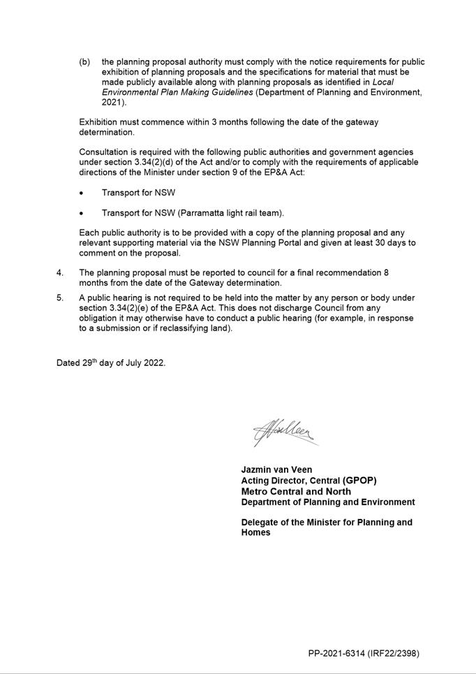
11. On 29 July 2022, the Department of Planning
and Environment issued a Gateway determination (Attachment 5) with an
expiry date of 31 May 2023 which allowed the Planning Proposal to proceed to
public exhibition.
12. The Planning Proposal and draft Planning
Agreement were publicly exhibited from 12 October 2022 to 9 November 2022. This
report addresses the outcomes of that exhibition and makes recommendations for
progressing the matter.
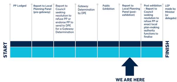
PLANNING PROPOSAL
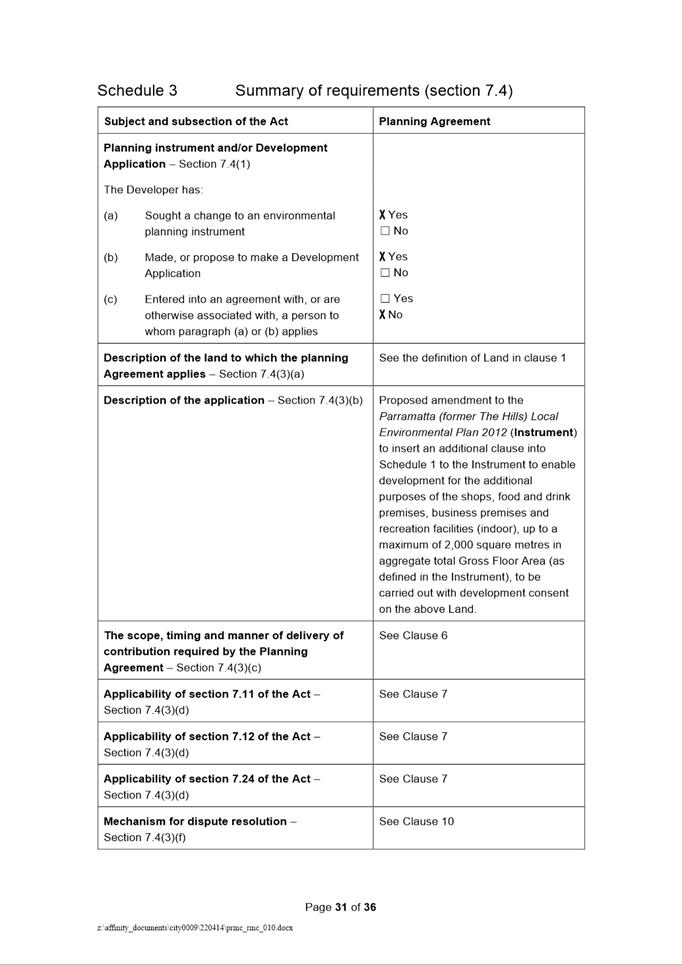
TIMELINE
SITE DESCRIPTION
13. The subject site is known as at 263-273 &
279R Pennant Hills Road and 18 Shirley Street, Carlingford and comprises of 8
lots which are legally described as follows in Table 1:
Table
1 – Property address, Lots and DPs
|
Property Address
|
Lot & DP
|
|
263 Pennant Hills Road
|
Lot 22, DP 21386
|
|
265 Pennant Hills Road
|
Lot 2, DP 9614
|
|
267 Pennant Hills Road
|
Lot 3, DP 9614
|
|
269 Pennant Hills Road
|
Lot 4, DP 9614
|
|
271 Pennant Hills Road
|
Lot 62, DP 819136
|
|
273 Pennant Hills Road
|
Lot 61, DP 819163
|
|
279R Pennant Hills Road
|
Lot 1, DP 531044
|
|
18 Shirley Street
|
Lot 1, DP 1219291
|
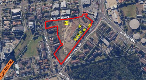
14. The site has a total area
of approximately 27,985sqm (Figure 2).
15. The site is located on the
eastern side of Pennant Hills Road (classified road) and the northern and
western sides of Shirley Street (local road). The site is predominately
undeveloped and cleared of vegetation however there are five detached
two-storey dwellings fronting Pennant Hills Road.
16. A pedestrian pathway runs
along Pennant Hills Road, with connections into Lloyds Avenue to the south and
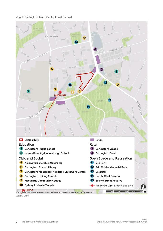
Carlingford Town Centre to the north. The site is located approximately 400
metres east from of the Carlingford Light Rail stop (under construction).
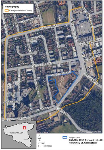
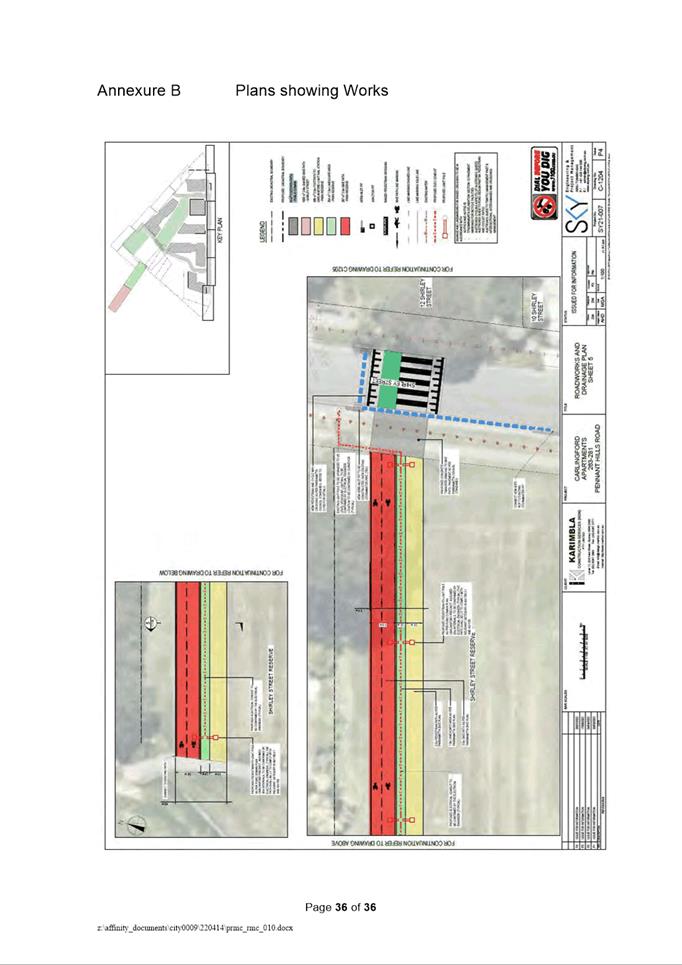
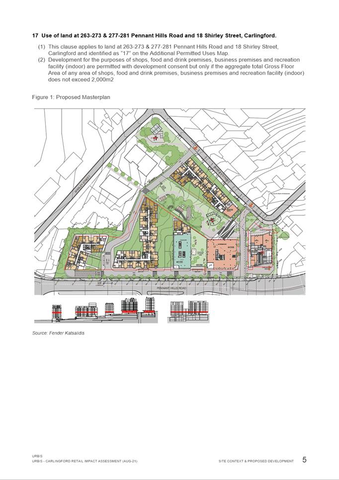
Figure 1 – Location of subject site within
the Carlingford Precinct
 Figure
2 – Subject Site in proximity to light rail stop
Figure
2 – Subject Site in proximity to light rail stop
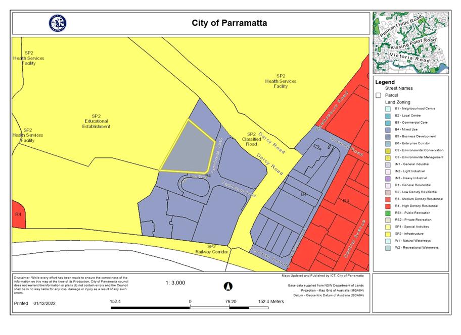
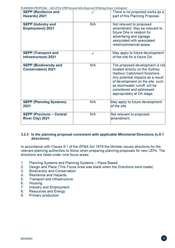
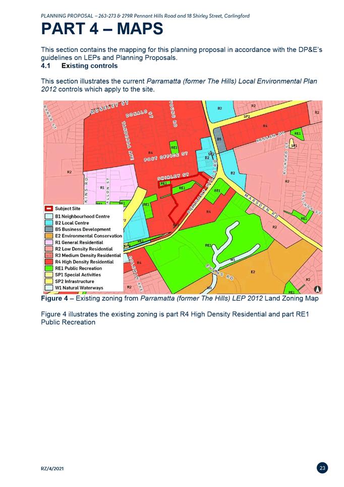
CURRENT PLANNING CONTROLS
17. The subject site is zoned
part R4 High Density Residential, part RE1 Public Recreation and Part SP2
Infrastructure under the provisions of the Parramatta (former The Hills) Local
Environmental Plan as shown in Figure 3. This Planning Proposal only
amends the controls for the land zoned R4 High Density Residential. The current
zoning is to be maintained.
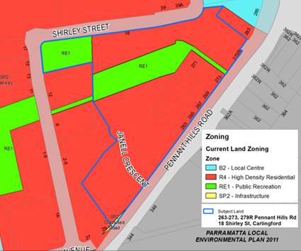
Figure 3 – Current Zoning
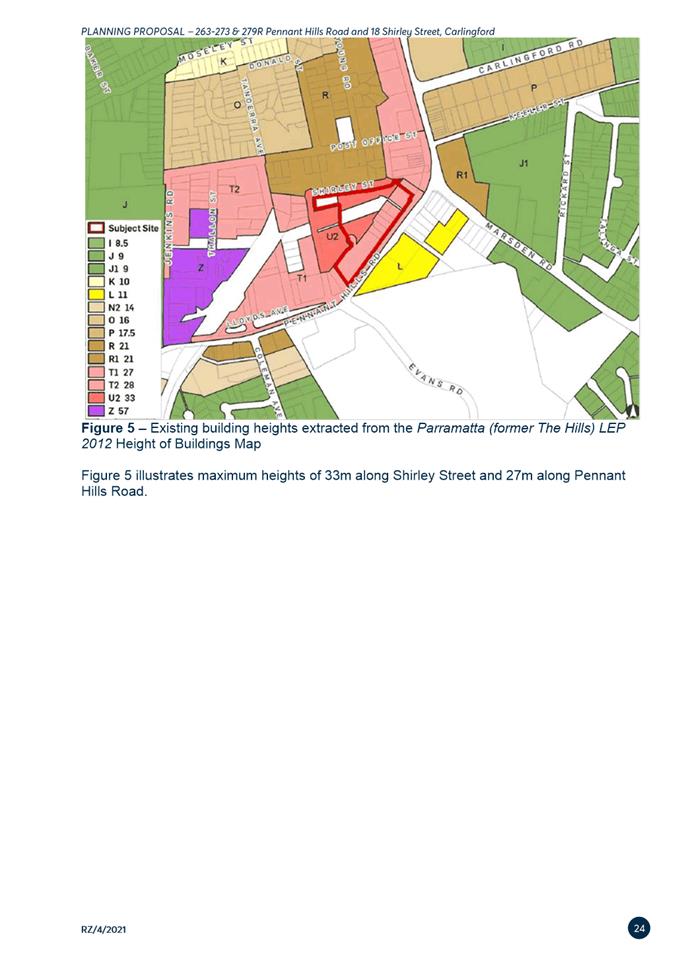
18. The site currently has a
height limit of 27 metres (6 storeys) fronting Pennant Hills Road and 33 metres
(9 storeys) fronting Shirley Street under the Height of Buildings (HOB) map
(refer to Figure 4). The current height is to be maintained.
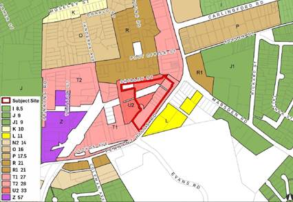
Figure 4 – Current Height
of Buildings
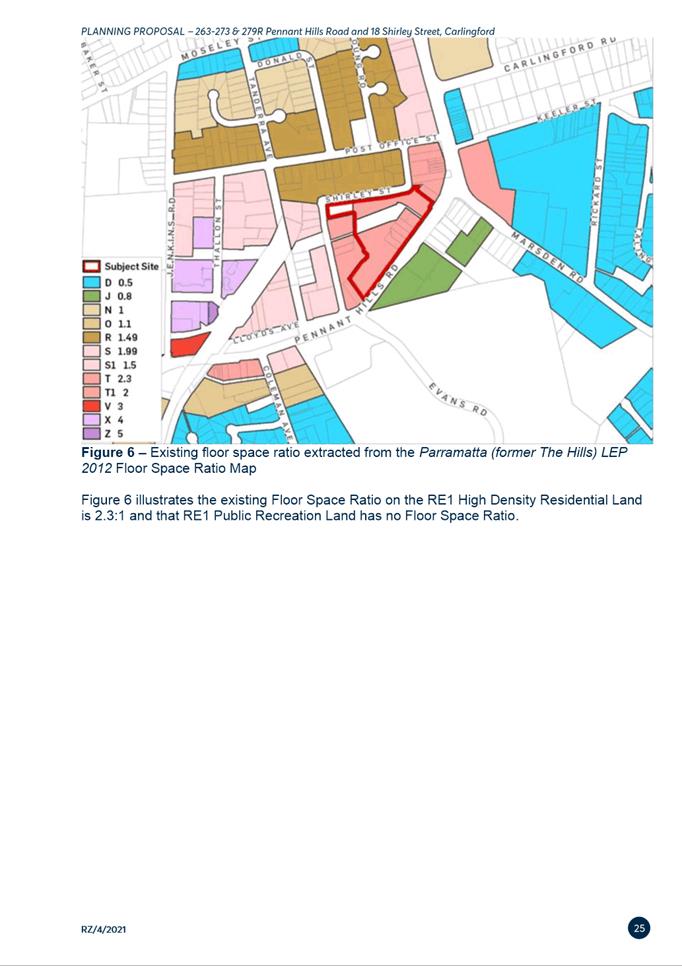
19. The
site currently has a floor space ratio of 2.3:1 under the Floor Space Ratio
(FSR) map (refer to Figure 5). The RE1 Public Recreation zoned land has
no nominated FSR. The current floor space ratio is to be maintained.
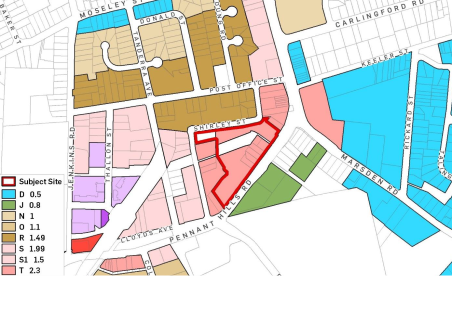
Figure 5 – Current Floor
Space Ratio
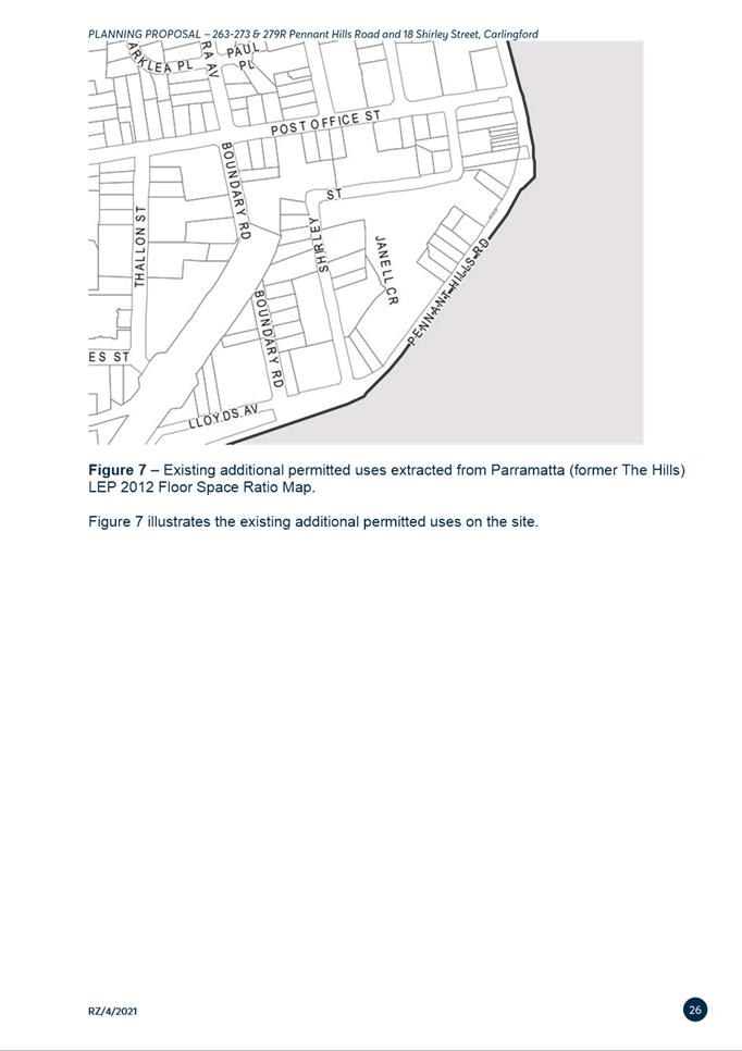
20. The site is not currently
on the Additional Permitted Uses Map (refer to Figure 6).
Figure 6 – Existing Additional Permitted Uses Map
PLANNING PROPOSAL
21. The objective of this
Planning Proposal is to facilitate the permissibility of ‘shops’
and ‘food and drink premises’ along with ‘business
premises’ and ‘recreational facility (indoor)’ up to a
combined total GFA of 2,000sqm on the R4 High Density Zoned areas of the site.
22. Specifically, the Planning
Proposal seeks to amend the Parramatta (former The Hills) Local Environmental
Plan 2012 as follows:
a. Amend Schedule 1 to permit ‘shops’ and ‘food and
drink premises’, ‘business premises’ and ‘recreational
facility (indoor)’ up to a combined total GFA of 2,000sqm on the R4 High
Density Residential zoned part of the site.
b. Addition of the R4 High Density
Residential zoned part of the site to the Additional Permitted Uses Map to
facilitate retail floor space, neighbourhood supermarket along with specialty
retail, business, and recreational uses.
23. A copy of the Planning Proposal is
included at Attachment 1.
24. The site is zoned R4 High
Density Residential which allows a range of non-residential (and commercial)
uses including childcare and minor neighbourhood shops, but not land uses which
the Planning Proposal intends to permit. Table 2 outlines the current non-residential
uses permitted within the R4 High Density Residential zone under the Parramatta
(former The Hills) LEP 2012 on the site and what is sought under the Planning
Proposal.
Table 2 –
Current and Proposed Permitted Non-Residential Land Uses on the subject site
|
Currently permitted non-residential
land uses within the R4 High Density
Residential zone
|
Proposed additional
permitted non-residential uses for the subject site under Planning Proposal
|
|
The Parramatta (former The Hills) LEP
2012 currently permits (with development consent) centre-based and home-based child care facilities; community
facilities; neighbourhood shops; places of public worship.
Specifically, ‘neighborhood
shops’ are defined under the Parramatta (former The Hills) LEP 2012 as
“premises used for the
purposes of selling general merchandise such as foodstuffs, personal care
products, newspapers and the like to provide for the day-to-day needs of
people who live or work in the local area, but does not include neighbourhood
supermarkets or restricted premises.” Under Clause 5.4 (7) of the LEP,
the retail floor area of neighbourhood shops must not exceed 100 square
metres.
|
Shops (smaller metro style supermarket), food and drink
premises, business premises and recreational facility
(indoor) up to a maximum combined gross floor area of 2,000sqm on the site.
The Parramatta (former The Hills) LEP
2012 defines that “Shops” are premises that sell merchandise
such as groceries, personal care products, clothing, music, homewares,
stationery, electrical goods or the like or that hire any such merchandise
and includes a neighbourhood shop and neighbourhood supermarket.
|
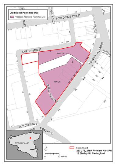
Figure 7 - Proposed amendment to the Additional Permitted Use Map
PLANNING AGREEMENT
25. The Planning Proposal is
accompanied by a draft Planning Agreement (Attachment 2) which proposes
to deliver the following public benefits:
i. A shared walking/cycling pathway through
Council owned Shirley Street Reserve which forms part of the connection to the
Carlingford Light Rail stop; and
ii. A raised pedestrian crossing on Shirley Street
accommodating cyclists and pedestrians.
26. It is noted that the
Department of Planning and Environment (DPE) Planning Agreements Practice Note
(February 2021) seeks to move away from value capture (as referred to in
Council’s Planning Agreements Policy 2018) towards an infrastructure
needs approach to negotiating planning agreements.
27. The purpose of the draft
Planning Agreement is to provide for local infrastructure works required to be
delivered as a result of the proposed redevelopment of the site and therefore
is consistent with the objectives of the Practice Note.
28. The draft Planning
Agreement offers a pedestrian link from the subject site to deliver a part of
the planned cycle/pedestrian network on public land adjacent to the site which
will improve connectivity and access to the Parramatta Light Rail for the wider
Carlingford precinct and surrounding neighbourhood, and a pedestrian crossing
on Shirley Street (see Figure 8).
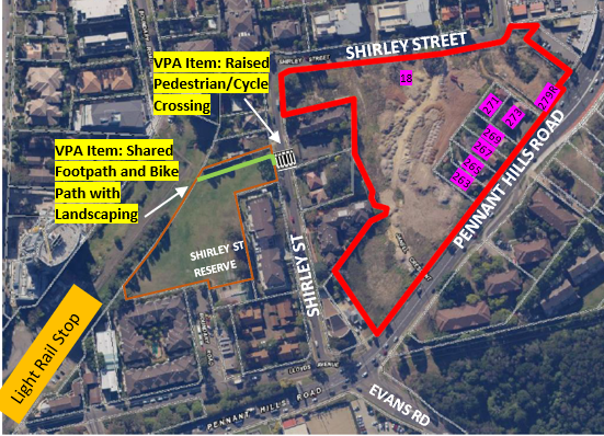
Figure 8 – Subject
Site and Planning Agreement Items
29. The draft Planning
Agreement has been identified as an appropriate mechanism to ensure the
increase in demand for infrastructure due to the Planning Proposal is
satisfactorily addressed. The additional land uses sought by the Planning
Proposal will increase the land value as they will allow for a supermarket
facilitating higher rental value for the site (within a residential zone) and
further ongoing revenue as it will bring more pedestrian traffic to the site.
The shared path and crossing from the site to the light rail noted in the draft
Planning Agreement relate to the provision of community infrastructure that
will directly benefit and service future development at the site given the
likely increase in demand for services and infrastructure arising from the
Planning Proposal.
30. It is noted that the site
is already subject to an existing Planning Agreement. That Planning Agreement
was entered into in April 2015 between The Hills Shire Council and the then
owners. The land subject to the Planning Agreement originally comprised of
various lots previously known as 14-30 Shirley Street and 2-10 Janell Crescent,
Carlingford, which have since been consolidated as 18 Shirley Street,
Carlingford. In summary, this Planning Agreement provided for the following to
be provided to The Hills Shire Council:
· Dedication of land for public open space.
· Works in kind (including embellishment of public open
space) – estimated value $742,108.
· Monetary contribution (to be spent in Carlingford Precinct)
– estimated value $920,984 (subject to CPI increases).
31. The Planning Agreement was
transferred from The Hills Shire Council to City of Parramatta Council on 12
May 2016, when the land subject to this Planning Agreement moved into the City
of Parramatta local government area.
32. On 7 December 2020,
Dyldam (and its subsidiaries) exchanged contracts for sale with Karimbla
Properties (No. 61) Pty Limited (a subsidiary of Meriton Group). The Deed of
Novation included a contractual obligation that the purchaser must re-execute
the Planning Agreement with Council. This was undertaken in 2021 once
settlement of the land transfer had occurred. The land, works and monetary
contribution subject to the existing planning agreement have not yet been
delivered but will be required as part of approved development application.
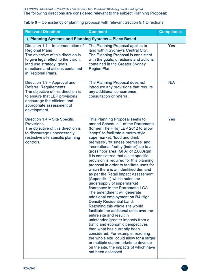
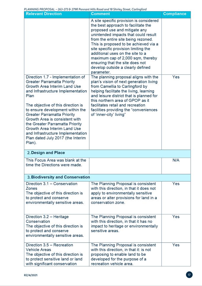
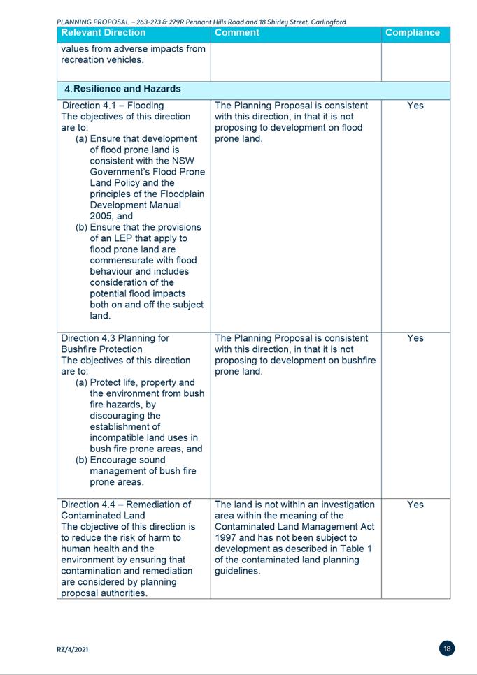
SITE SPECIFIC
DEVELOPMENT CONTROL PLAN
33. It is noted that the
Planning Proposal is only seeking to include additional permitted uses within
Schedule 1 of the Parramatta (former The Hills) Local Environmental Plan 2012.
It is therefore not necessary to include a site-specific DCP to support the
proposal in this instance. The existing provisions within The Hills Shire DCP
2012 are considered sufficient to manage the assessment of any development
application on the site should the proposal proceed.
PUBLIC EXHIBITION
AND CONSULTATION
34. The Planning Proposal,
draft Planning Agreement and supporting documentation were publicly exhibited
for 28 days from 12 October 2022 to 9 November 2022 as required by the Gateway
Determination. Notification methods used in the exhibition included:
· Letters to surrounding landowners, including
letters translated to Simplified Chinese.
· Dedicated exhibition page on Council’s
Participate Parramatta website.
· Advertisement on Council’s website.
· Advertisement in the Parra News.
· Exhibition folders in Council’s customer
service centre and Carlingford Library.
35. Public agencies were also
notified in writing of the public exhibition in accordance with the Gateway
determination, with the following agencies consulted:
· Transport for NSW
· Transport for NSW (Parramatta Light Rail team).
36. A total of four (4)
submissions were received comprising three (3) from the community, with the
remaining one (1) agency submission from Transport for NSW (breakdown provided
in Table 3). Overall, one submission supported the proposal and the
draft Planning Agreement in full, one objected in full, and one partially
supported the Proposal. The agency submission from TfNSW neither stated
objection or support.
Table 3 -
Breakdown of submissions received
|
|
Number
|
Breakdown
|
|
Community/landowners
|
3
|
various
landowners
|
|
Public Agencies
|
1
|
Transport
for NSW
|
|
Total
|
4
|
|
COUNCIL OFFICER RESPONSE TO KEY ISSUES RAISED IN
SUBMISSIONS
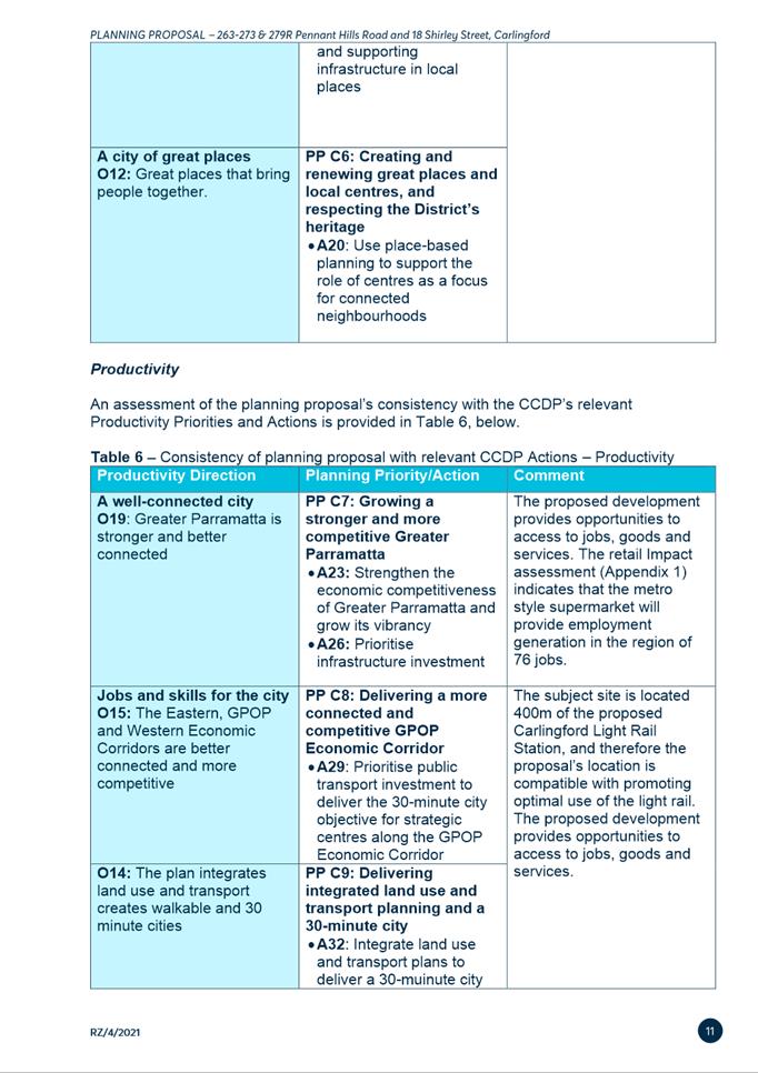
37. Table 4 summarises the key
issues raised in the community submissions including a Council officer’s
response.
Table 4 - Summary of issues raised by the community
during public exhibition period
|
Submission Number
|
Submission Summary
|
Council Officer Response
|
|
1
|
Object
· Submitter considers that the addition of a supermarket is
not needed.
· Submitter considers that the supermarket will generate
additional traffic.
|
The proposed
supermarket will assist in addressing the substantial undersupply of
supermarket floorspace within the Carlingford area. The Retail Impact
Assessment (Attachment 3) notes there is sufficient supermarket
floorspace demand over the short to long term to justify the proposed
development on the subject site
As a result of the
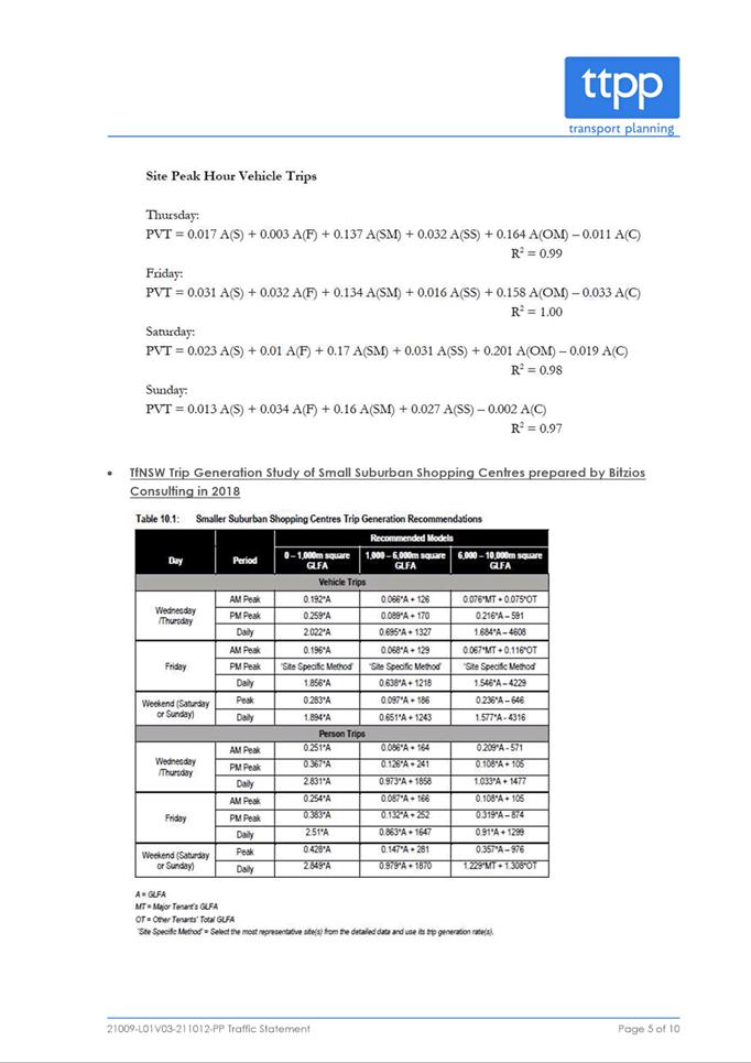
proposal, the expected additional trips on the main road network would be
limited to around 47 to 113 vehicles per hour (vph) during the weekday AM
peak period and around 92 to 152 vph in the PM peak periods, which is
equivalent to one to three additional vehicles per minute, which is
considered minor in the surrounding context.
The traffic and
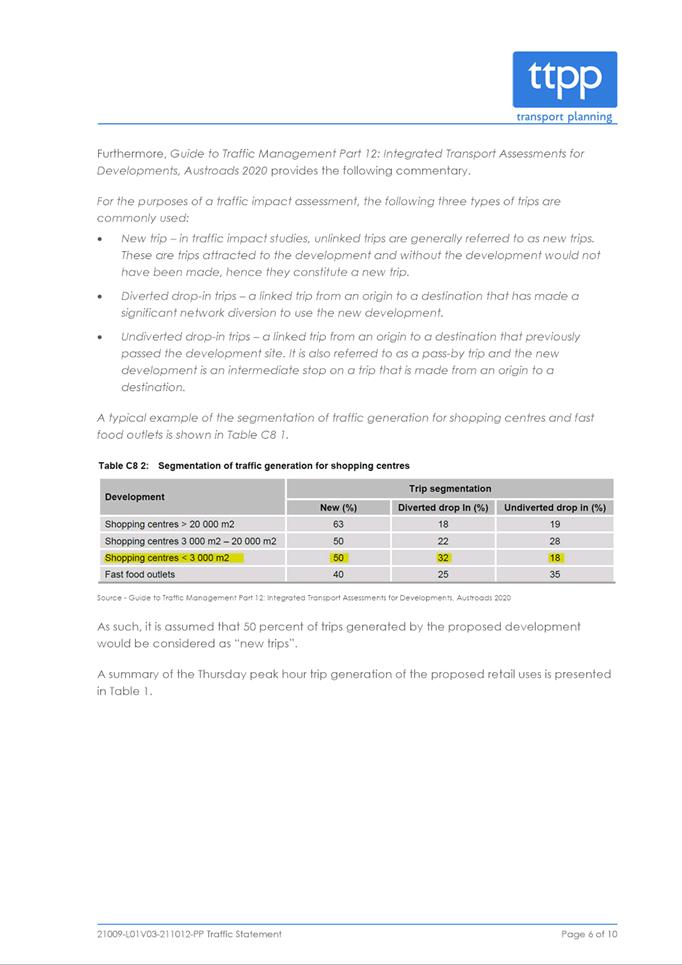
parking assessment (Attachment 4) notes if there is no retail
component within this precinct, then trips to retail developments beyond the
site by the approved residential component would generate external trips to
the road network to access other local retail centers.
The site would
accommodate a small neighbourhood supermarket which will provide limited day
to day items and groceries so it will not necessarily require or encourage
access by cars unlike larger format supermarkets.
|
|
2
|
Support
· The submitter queries if the traffic assessment includes
delivery vehicle trips and that delivery vehicles would require different
roadway specifications to passenger vehicles.
· The submitter notes the proposal provides good local
access to food supplies.
|
The traffic and
parking assessment does not specifically note delivery vehicle trips however
given the limited nature of the retail component they would be less than
passenger vehicle trips which are considered to be minor in the surrounding
context and are deemed acceptable by Council Officers.
Roadway
specifications for both passenger and delivery vehicles will be assessed in
detail at development application stage.
Noted.
|
|
3
|
· The submitter noted that infrastructure in Carlingford is
over stretched with road issues and there are existing potholes.
· The submitter considers the above issues need rectifying
before adding additional density to the site.
|
Additional
infrastructure is being provided within the proposed planning agreement which
will facilitate a raised pedestrian/cycle crossing over Shirley Street and a
shared pedestrian/cycle path through Shirley Street Reserve.
Rectification works
to potholes cannot be delivered as a part of this Planning Proposal.
Council’s customer service centre can be contacted to report potholes
or other damage to the local road network.
The Planning Proposal
only introduces additional permitted uses of shops,
food and drink premises, business premises and recreational facility (indoor)
to the site. The proposal will not facilitate any residential development
and will not result in an increase in residential density on the site.
|
AGENCY SUBMISSIONS
Transport for NSW
38. The planning proposal was
referred to TfNSW for comment. TfNSW do not object to the Planning Proposal but
raise matters for consideration.
39. Table 5 below
summarises the key issues including a Council officer’s response.
Table 5 - Summary of Issues raised by TfNSW during public
exhibition period
|
Consultation
Issues
|
Council Officer
Response
|
|
The subject site is partly over
land owned by Transport for NSW (Road), being Lot 1 DP531044. This land is
yet to be dedicated as public road. Should landowners’ consent be required
for any future proposed works over TfNSW owned land, the proponent would be
required to contact the Regional Land Information & Corridors.
|
Noted. This matter
will be considered as part of any future development application on the site
and TfNSW and Regional Land Information
& Corridors will be
consulted.
|
|
The subject site is also
affected by a road proposal.
|
Noted. This matter
will be considered as part of any future development application on the site
and TfNSW will be consulted.
|
|
A sizable portion of traffic
generated by the proposal will utilise the Pennant Hills Road / Evans Road /
Shirley Street / Lloyds Avenue intersection in the future, thus adding
additional delay to vehicles safely turning onto Pennant Hills Road.
TfNSW currently does not have
any committed / funded upgrades at this intersection, it is likely that any
potential future upgrade of this intersection will require the land
identified in pink (Figure 9). As a minimum (to facilitate any
possible upgrade of this intersection in the future) the proponent should
dedicate the land identified in pink (located within Lot 1 DP1219291) as road
at no cost to TfNSW.
To
address the comments above, TfNSW requires the use of the Department of
Planning and Environment’s (DPE) Secretary’s Concurrence Clause
to ensure that this will occur at the subsequent Development Application
stage. Therefore, this shall require a new clause within Parramatta
(former The Hills) Local Environmental Plan 2012 under Part 7 –
Additional Local Provisions which would be applicable to 263-273 &
279R Pennant Hills Road and 18 Shirley Street, Carlingford, which would state
the following:
1. This clause applies to (insert land
description here – address / lot and DP).
2. Development consent must not be granted to
development on land to which this clause applies unless the consent authority
has obtained the concurrence of the Planning Secretary.
3. In deciding whether to grant concurrence, the
Planning Secretary must consider the potential effects of the development on
existing and proposed transport infrastructure in the locality.
4. The Planning Secretary must notify the consent
authority of the Planning Secretary’s decision within 21 days of
receiving the request for concurrence.
|
Council officers
agree that the piece of land noted by TfNSW (Figure 9) will be
required for a future road upgrade. The land is currently zoned SP2
Infrastructure and identified for acquisition by TfNSW. The issue has been
discussed with the Applicant which opposes the inclusion of the clause
proposed by TfNSW. Council officers do not consider it necessary to
include the additional LEP clause sought to achieve the outcome sought, as a
process for the acquisition of the land by TfNSW is already in place. The
matter can be dealt with at the development application stage.
|
|
Comment on the proposed shared
path in Shirley Street reserve being aligned with any future entrance to the
proposed supermarket/ground floor retail on Shirley Street.
|
This will be
considered as part of any future development application.
|
|
Figure 6 of the Carlingford
Precinct DCP shows that the shared path is potentially on the southern end of
Shirley Park. However, the draft VPA shows the proposed shared path on the
Northern end of the park. can this please be clarified with regards to the
location to ensure that the pedestrians have a direct connection
|
The exact location of
the shared path will be determined at development application stage and will
be subject to detailed design and assessment.
|
|
The concept drawings within the
draft VPA do not show the proposed shared path connecting to the shared path
that connects Carlingford Light Rail stop to Boundary Road.
|
Council Officers have
approached TfNSW and Greater River City Light Rail (GRCLR) to discuss the
connecting link between the proposed share pathway in the draft planning
agreement and the Parramatta Light Rail and Active Transport Link (ATL) and
are waiting for TfNSW and GRCLR to review the proposal with the aim to meet
and discuss further.
|
|
The supporting Traffic and
Parking Assessment did not conduct any detailed traffic modelling to clearly
identify the traffic impacts of the Planning Proposal on surrounding
intersections as the report was prepared at the time when covid restrictions
were starting to be relaxed. Subject to the approval of this Planning
Proposal, the proponent must ensure that appropriate traffic survey
collection and detailed traffic modelling (in accordance with TfNSW requirements)
is undertaken as part of a future Traffic and Transport Assessment Report
supporting the subsequent Development Application on this site.
|
Noted. Traffic survey collection and detailed traffic modelling
(in accordance with TfNSW requirements) will be undertaken as part of a
future Traffic and Transport Assessment Report supporting the subsequent
Development Application on this site.
|
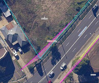
Figure 9 – Pink
section of Lot 1 DP 1219291 is land required
for future intersection upgrade at noted by TfNSW
FINANCIAL
IMPLICATIONS FOR COUNCIL
40. If Council resolves to
approve this report in accordance with the recommendation, the draft Planning
Agreement is for the following works to be conducted by the developer, with an
approximate value of $431,388.45 (subject to CPI):
i. A shared walking/cycling pathway through
Council owned Shirley Street Reserve which forms part of the connection to the
Carlingford Light Rail stop; and
ii. A raised pedestrian crossing accommodating both
cyclists and pedestrians on Shirley Street.
41. It is noted that land
identified as part of the future shared path and the pedestrian crossing is on
Council land and will be subject to ongoing maintenance costs. However, it is
acknowledged that these items will have a public benefit by facilitating an
improved part of the connection to the Carlingford Light Rail stop with the
boarder cycle/pedestrian network. Council Officers have approached TfNSW and
Greater River City Light Rail (GRCLR) to discuss the connecting link between
the proposed share pathway in the planning agreement and the Parramatta Light
Rail and Active Transport Link (ATL) and are waiting for TfNSW and GRCLR to
review the proposal with the aim to meet and discuss further.
42. It is proposed that the works
would be completed prior to an Occupation Certificate being issued for the
Additional Permitted Use on the site.
43. The costs associated with
the preparation, exhibition and finalisation of the draft Planning Agreement
involve internal resources and legal costs. The developer has/will reimburse
any legal costs relating to the negotiation and execution of the Planning
Agreement, which will then result in nil cost to Council for this item.
CONCLUSION AND NEXT
STEPS
44. It is recommended that the
Local Planning Panel supports the Council officer recommendation for Council to
approve for finalisation the exhibited Planning Proposal for 263-273 & 279R Pennant Hills Road and 18 Shirley
Street, Carlingford and exercise
its plan-making delegations as granted by the Gateway Determination. The LEP
amendment will then be signed by the CEO before being notified on the NSW
Legislation website.
45. It is recommended that the
Local Planning Panel supports the Council officer recommendation for Council to
execute the draft Planning Agreement for 263-273 & 279R Pennant Hills Road
and 18 Shirley Street, Carlingford.
46. Following Local Planning
Panel consideration of the recommendations of this report, the outcomes of the
exhibition period for the Planning Proposal and draft Planning Agreement will
be reported to an upcoming Council meeting along with the Panel’s advice.
Rafael Morrissey
Project Officer Land Use
Belinda Borg
Team Leader Land Use Planning
David Birds
Group Manager, Major Projects and
Precincts
Jennifer Concato
Executive Director City Planning and
Design
Attachments:
|
1⇩
|
Planning Proposal
|
34 Pages
|
|
|
2⇩
|
Draft Planning Agreement
|
36 Pages
|
|
|
3⇩ 
|
Retail Impact Assessment
|
28 Pages
|
|
|
4⇩
|
Traffic and Parking Assessment
|
10 Pages
|
|
|
5⇩
|
Gateway Determination
|
2 Pages
|
|
REFERENCE MATERIAL
|
Item 6.1 - Attachment
1
|
Planning Proposal
|
|
Item 6.1 - Attachment 2
|
Draft Planning Agreement
|
|
Item 6.1 - Attachment 3
|
Retail Impact Assessment
|

|
Item 6.1 - Attachment 4
|
Traffic and Parking Assessment
|
|
Item 6.1 - Attachment 5
|
Gateway Determination
|