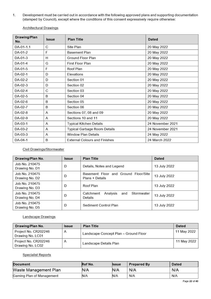
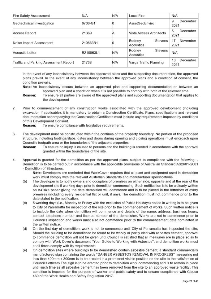
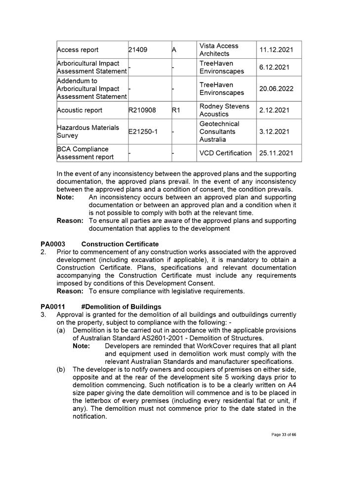
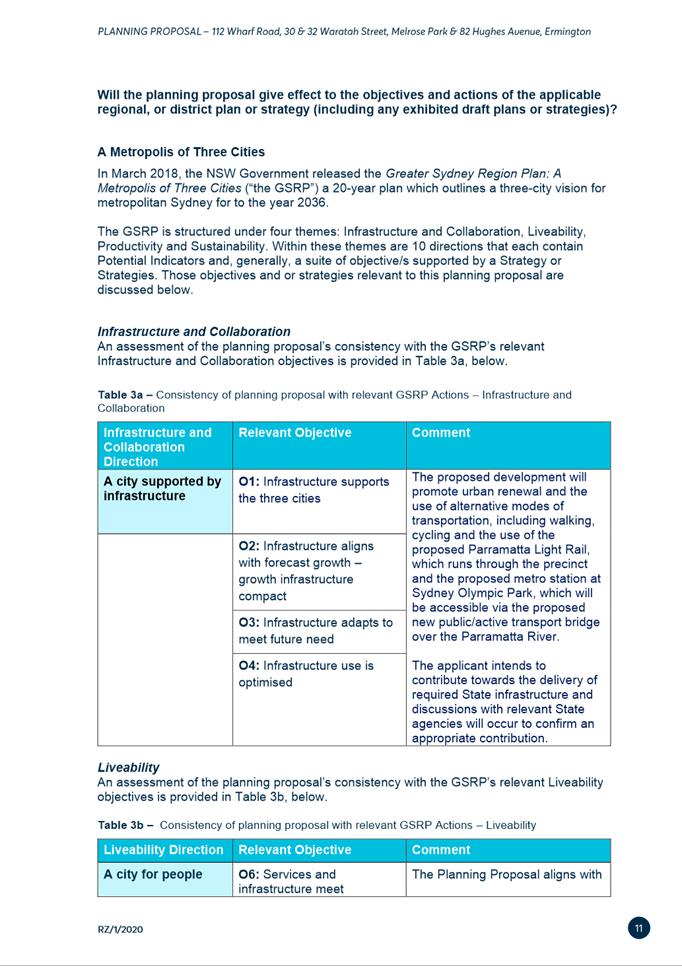
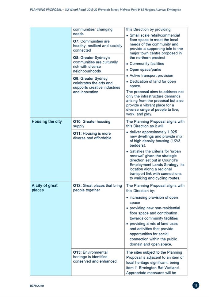
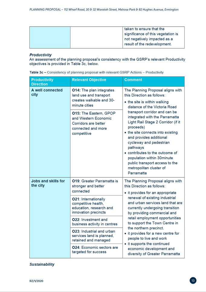
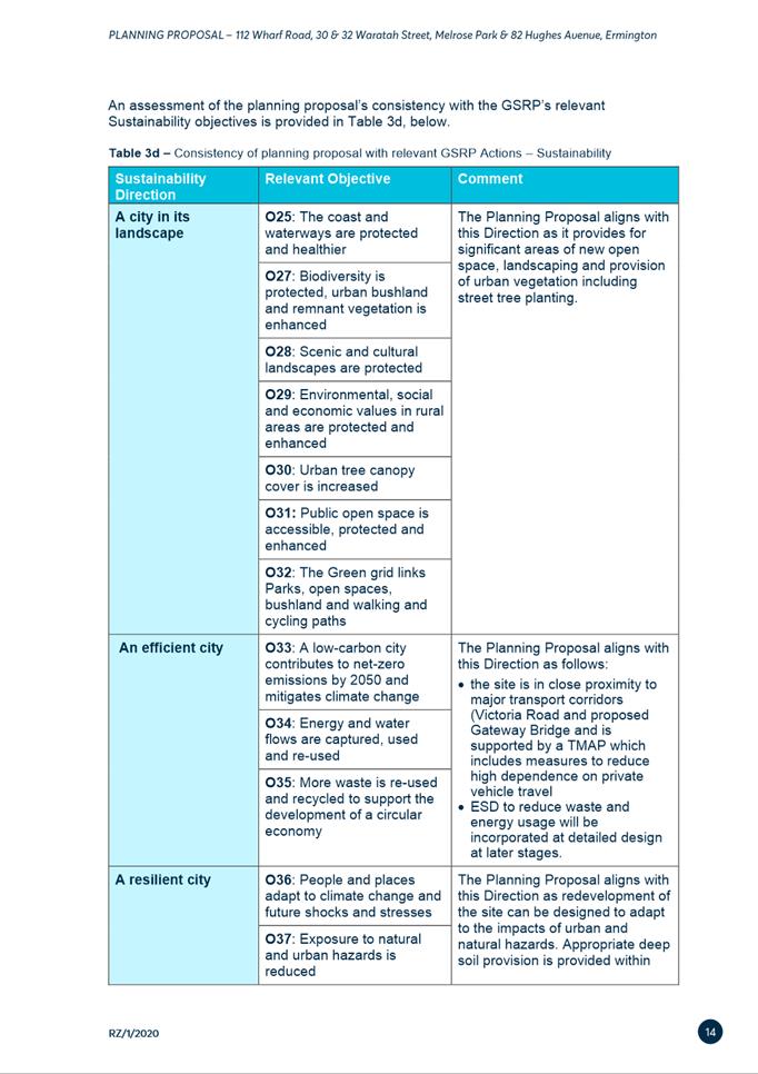
Local Planning Panel 15 November 2022 Item
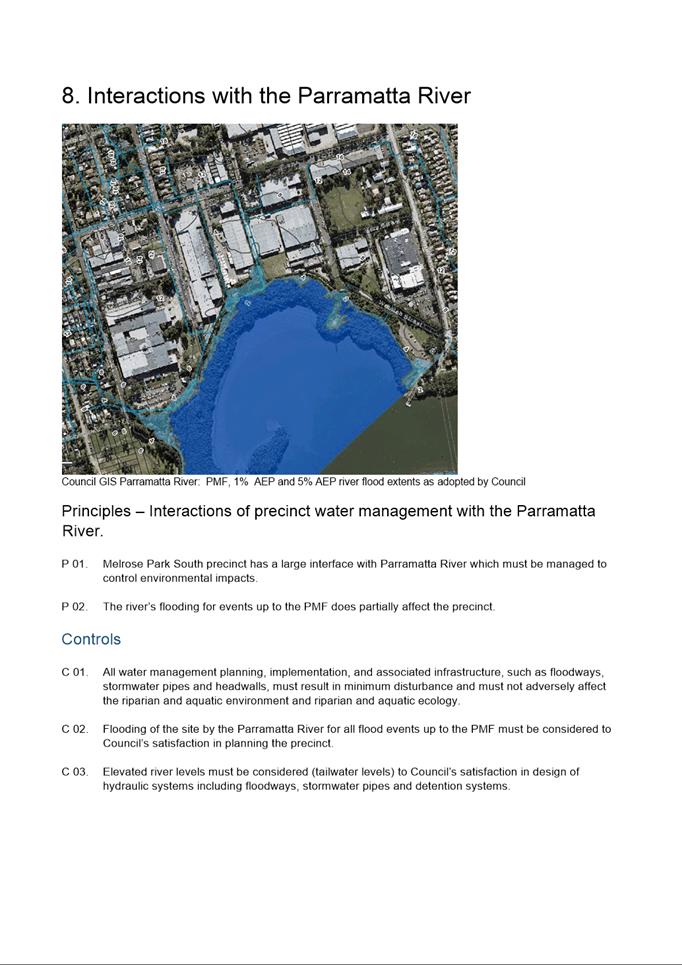
5.1
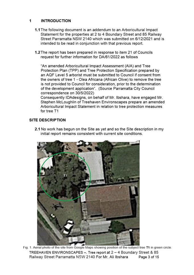
ITEM NUMBER 5.1
SUBJECT PUBLIC MEETING: 136 Church Street, PARRAMATTA NSW 2150 (Lot 1 DP
774940)
DESCRIPTION Alterations and additions and provision of signage to the existing
building for use as a licenced pub operating 10am to 4am Monday to Saturday and
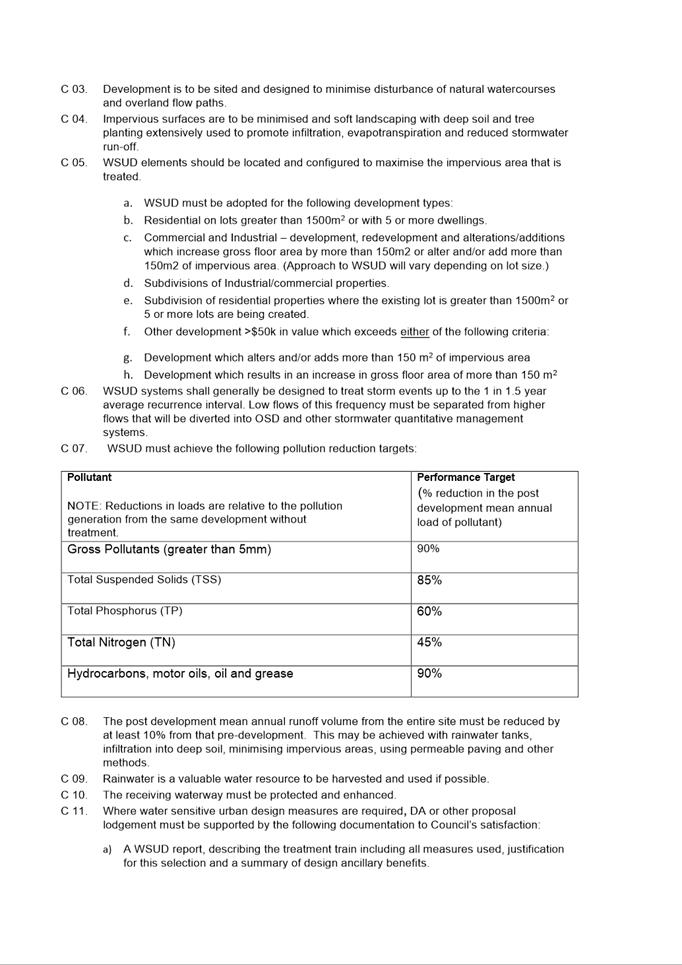
10am to midnight Sunday.
REFERENCE DA/10/2022 - D08716327
APPLICANT/S Think Planners
OWNERS H S Wong and X H W Liu
REPORT OF Group
Manager Development and Traffic Services
RECOMMENDED Approval
DATE OF REPORT 6 October 2022
REASON FOR REFERRAL
TO LPP
The application is referred to the Parramatta Local Planning
Panel:
1. as
the proposal seeks approval for the use of the premises as a licensed premise
(pub) and
2. the
application has ten (10) unique objections
EXECUTIVE SUMMARY
This is a summary of the full assessment of the application,
the Section 4.15 Assessment Report, Attachment 1.
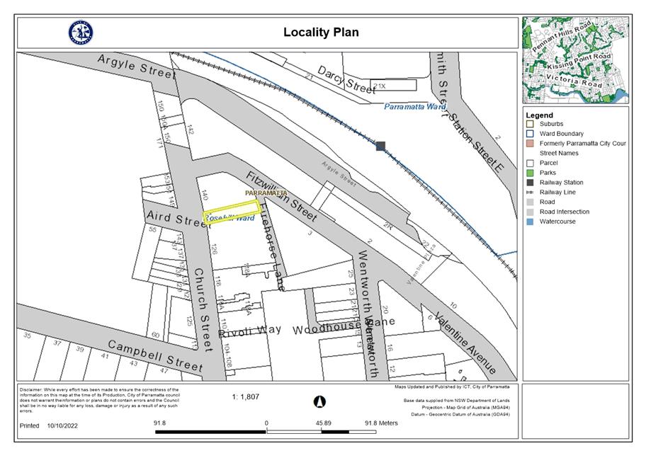
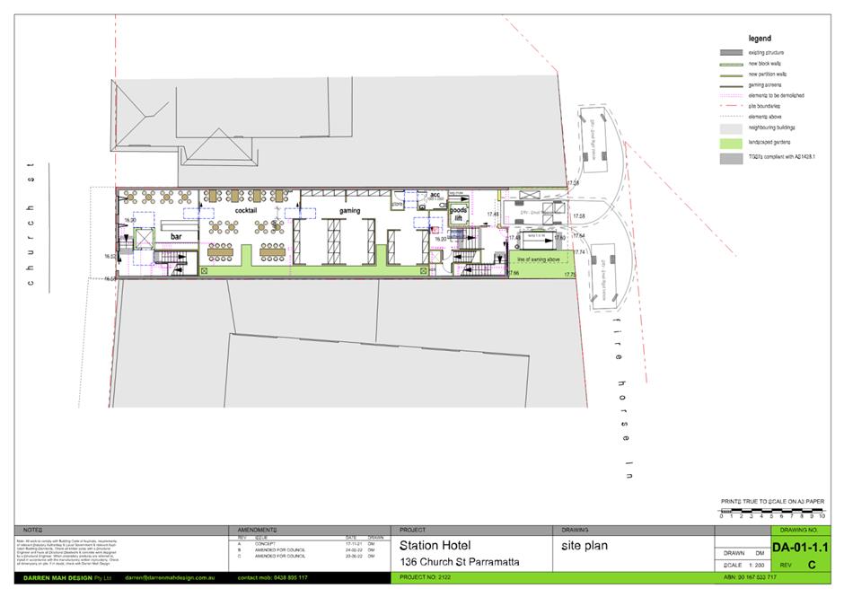
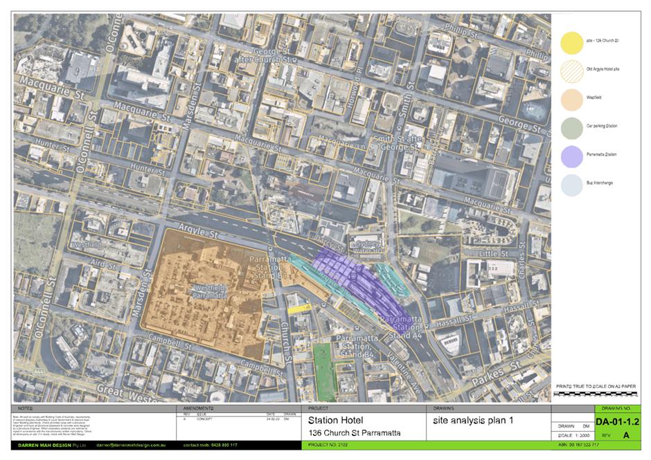
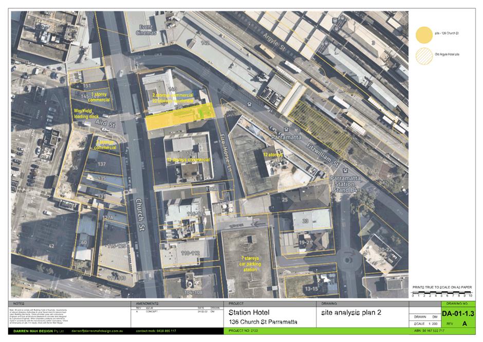
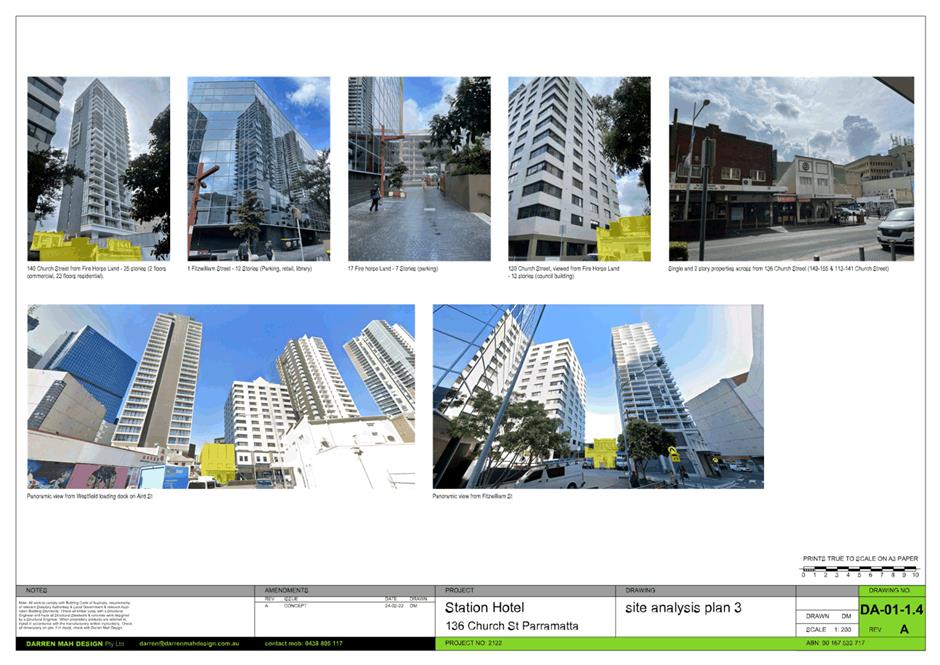
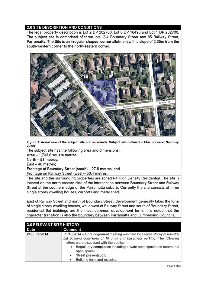
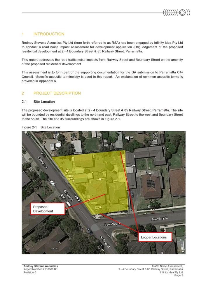
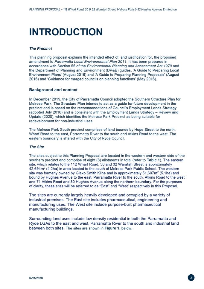
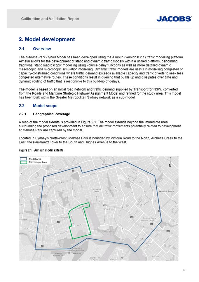
Site
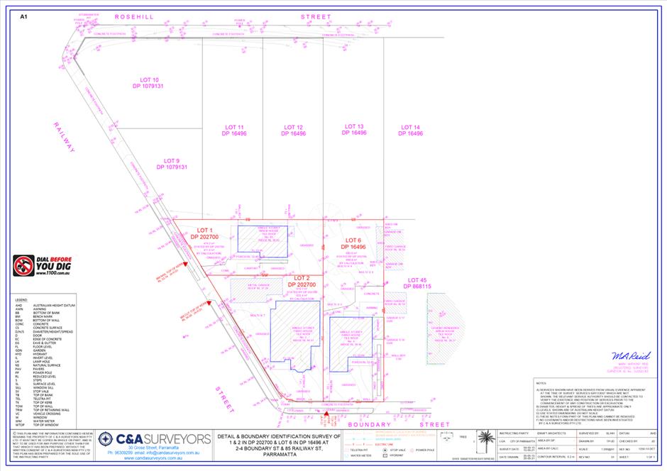
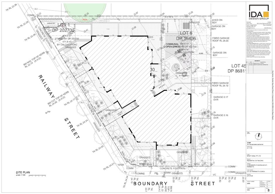
The subject site is known as 136 Church Street, Parramatta (Lot 1 DP 774940). The site has an area of 413.7m2
and currently accommodates a 2-storey retail building. The site has dual
frontage to Church Street of 9.145 metres and a secondary frontage to Fire
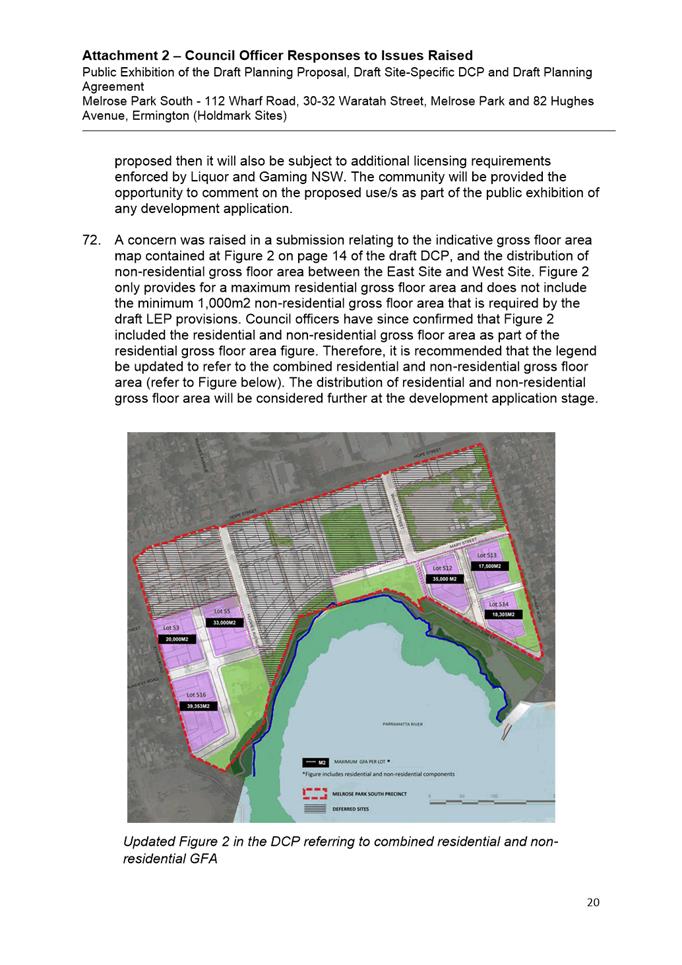
Horse Lane of 9.11 metres.
It is located within the Parramatta CBD which is
characterised by high density developments comprising a range of uses such as
residential, commercial, and retail. The site is also in proximity to public
transport.
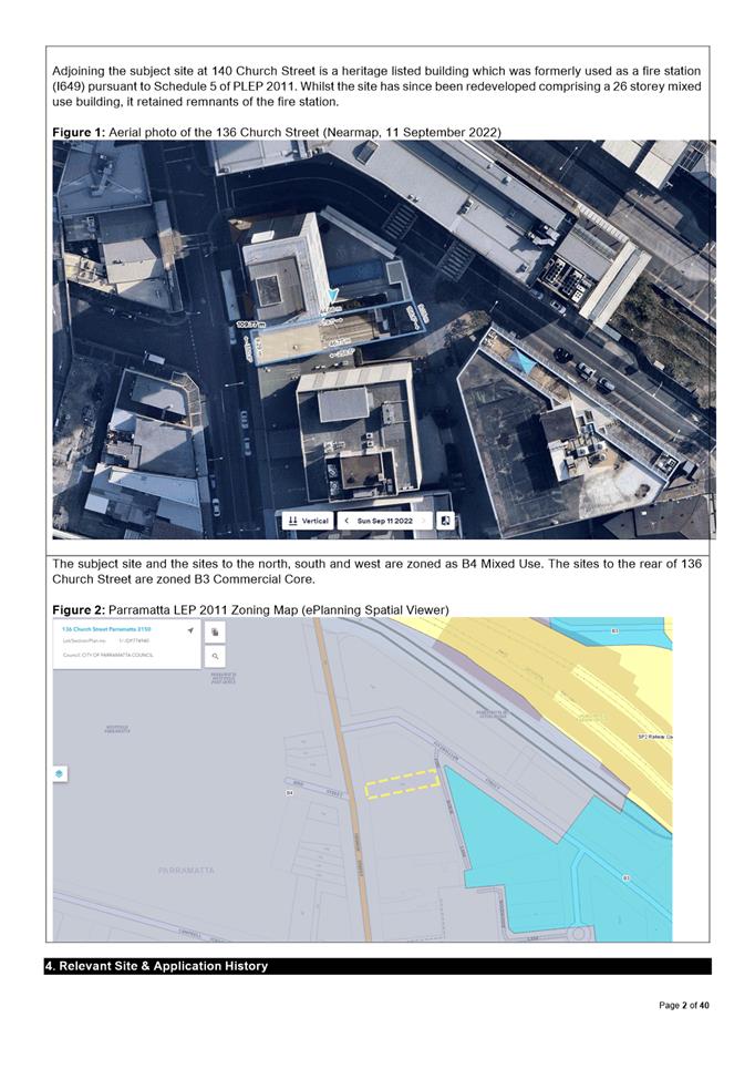
Adjoining the subject site at 140 Church Street is a
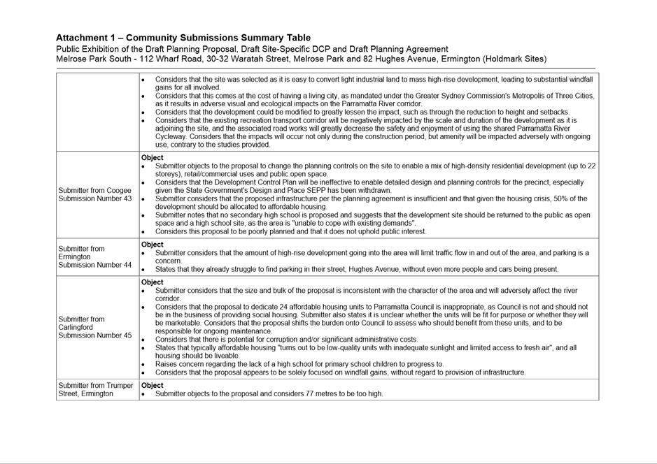
heritage listed building which was formerly used as a fire station (I649)
pursuant to Schedule 5 of Parramatta Local Environmental Plan (PLEP) 2011.
Whilst the site has since been redeveloped comprising a 26-storey mixed use
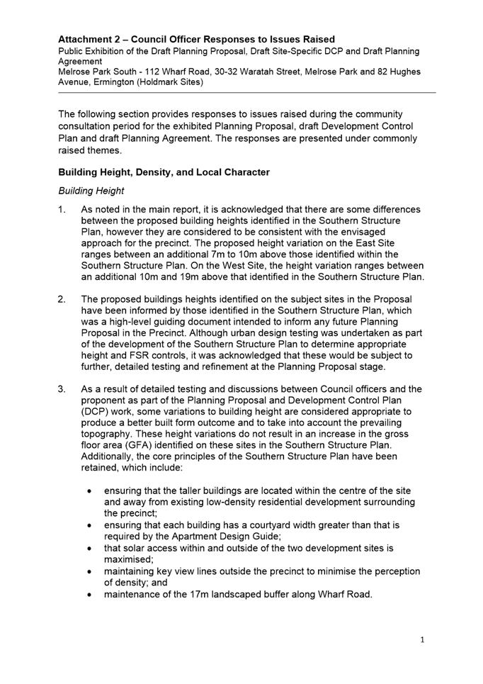
building, it retained remnants of the fire station.
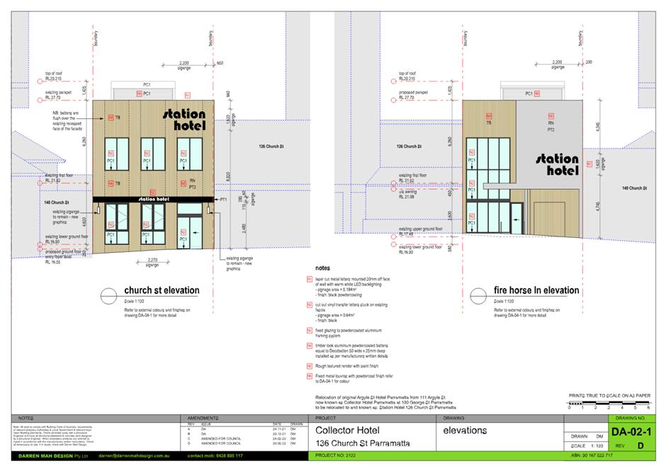
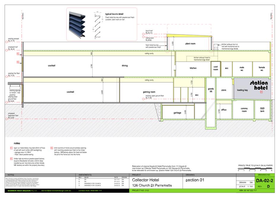
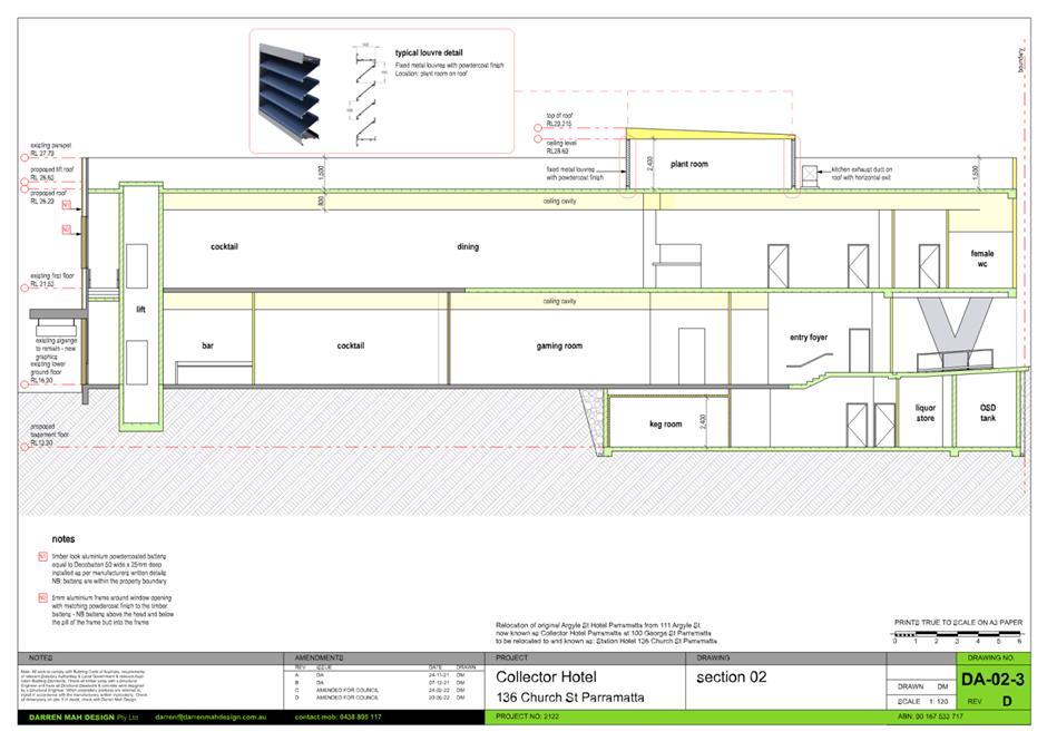
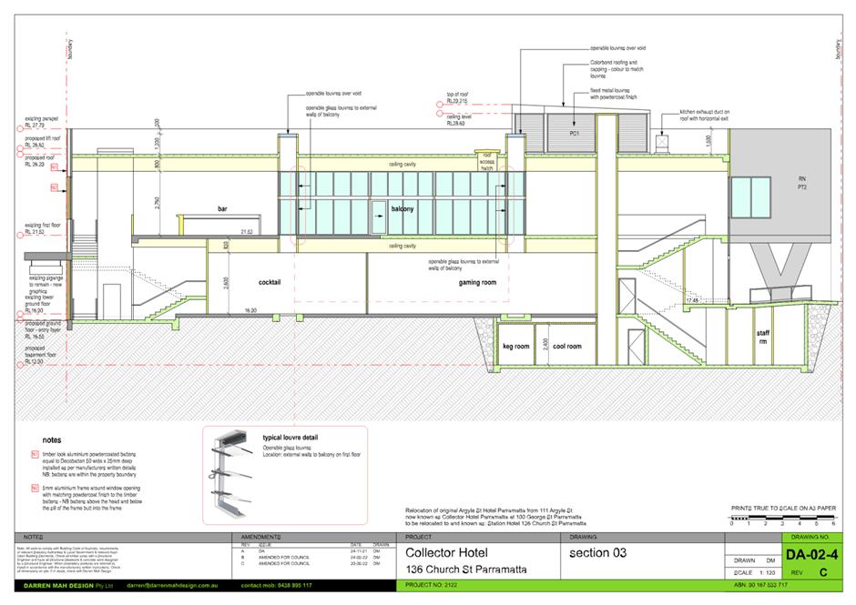
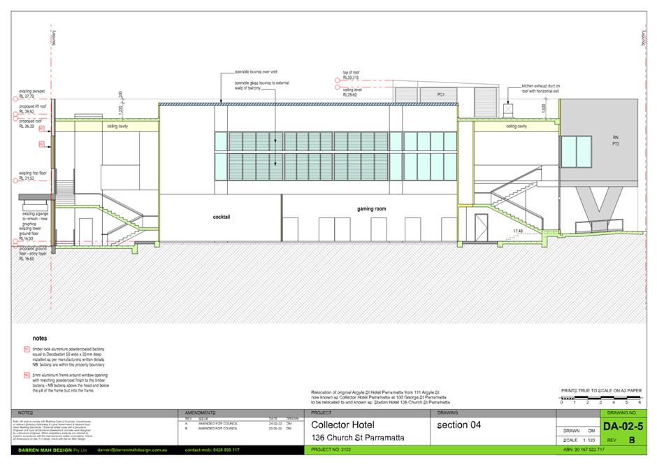
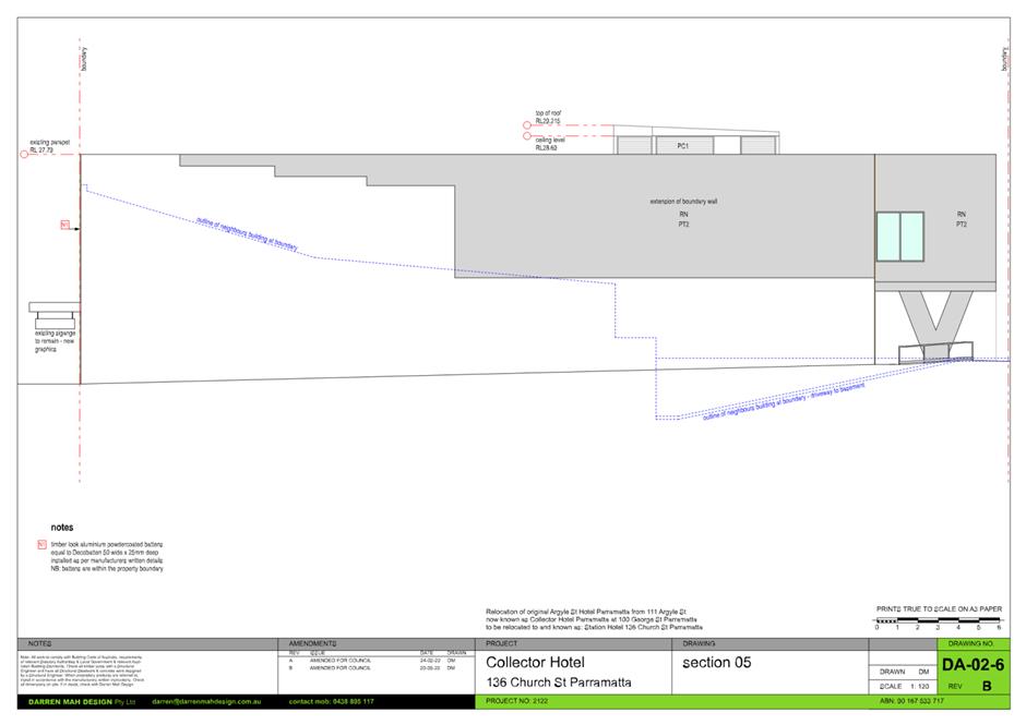
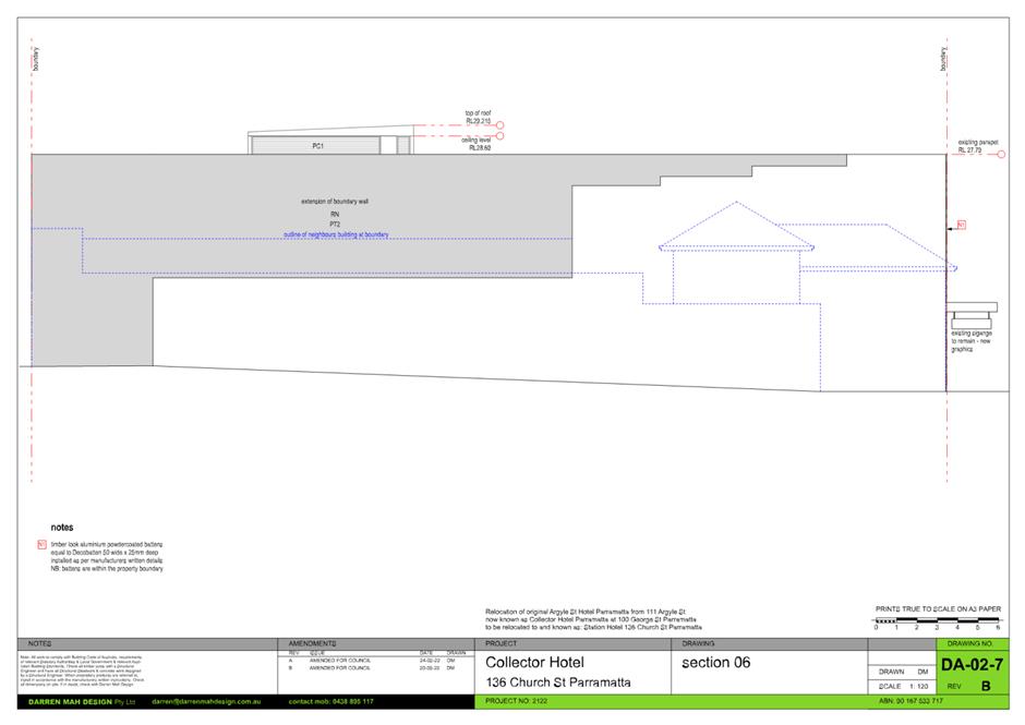
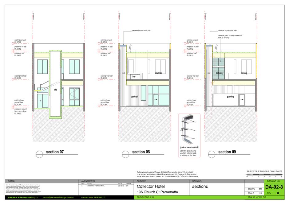
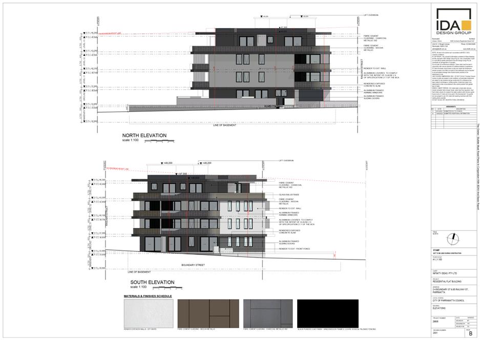
The Proposal
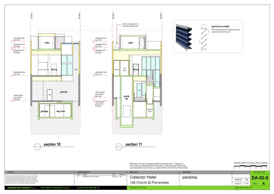
Consent is sought for the alterations and additions to the
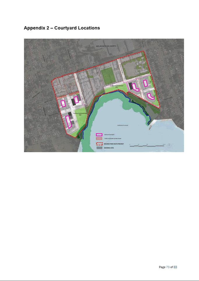
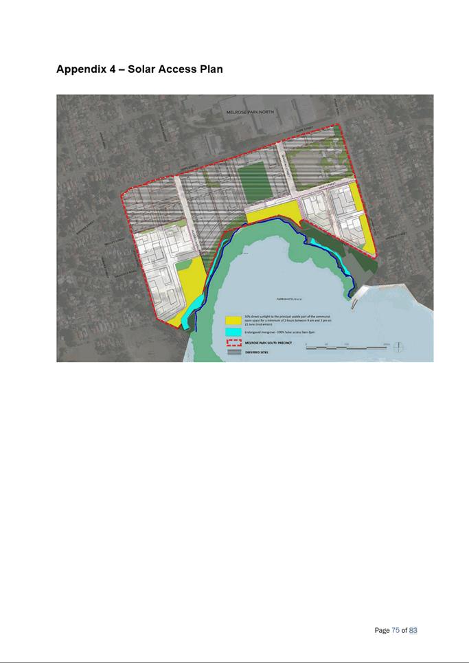
existing 2 storey building on the site to facilitate its use as a pub. The
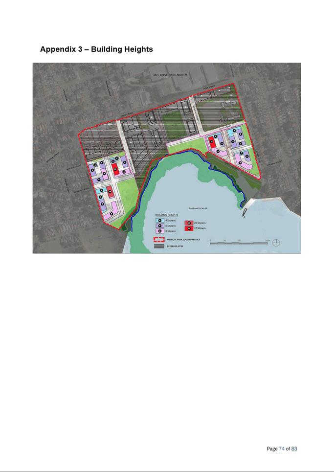
proposed development includes the following components:
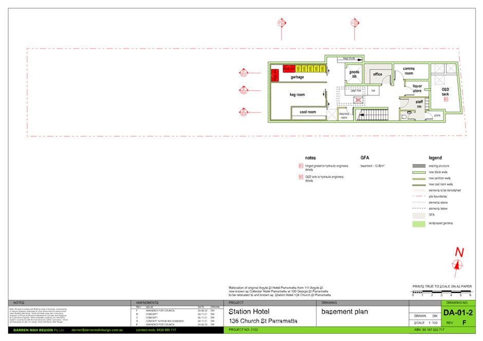
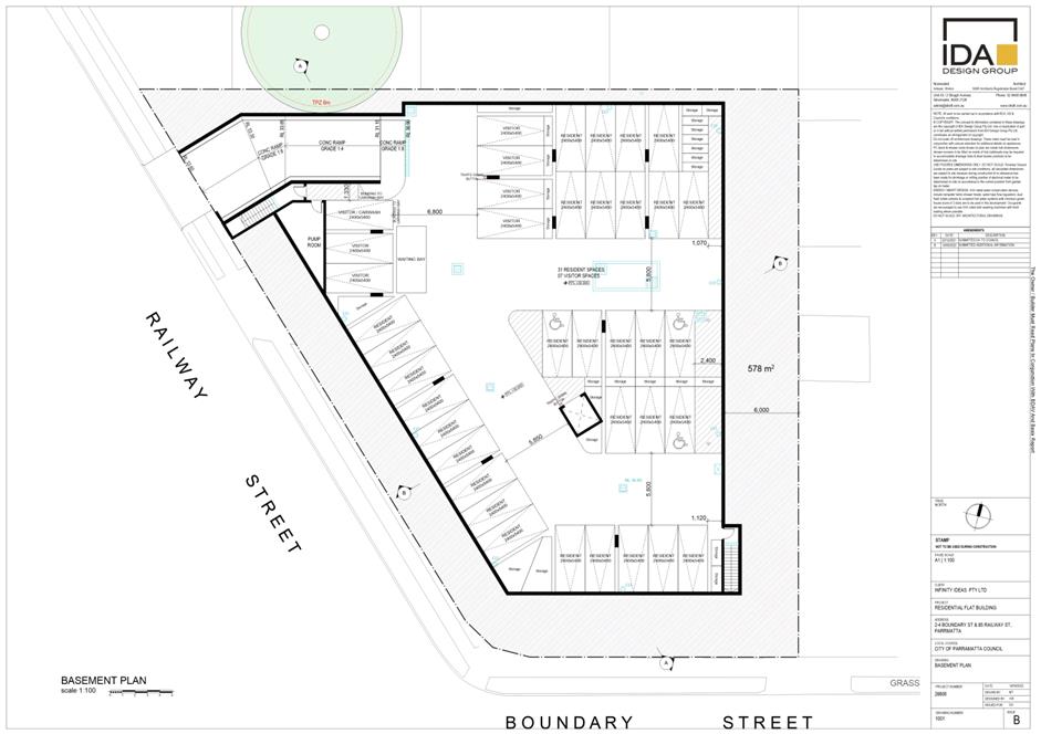
1. Construction
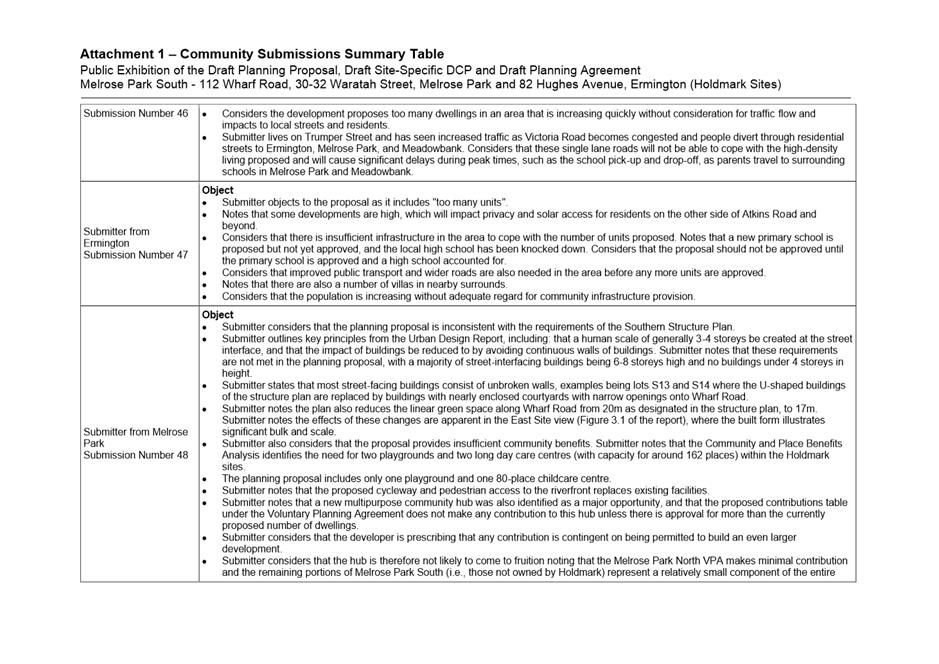
of a basement level that will contain the keg room, garbage room, storage,
staff room office and staff amenities.
2. Changes
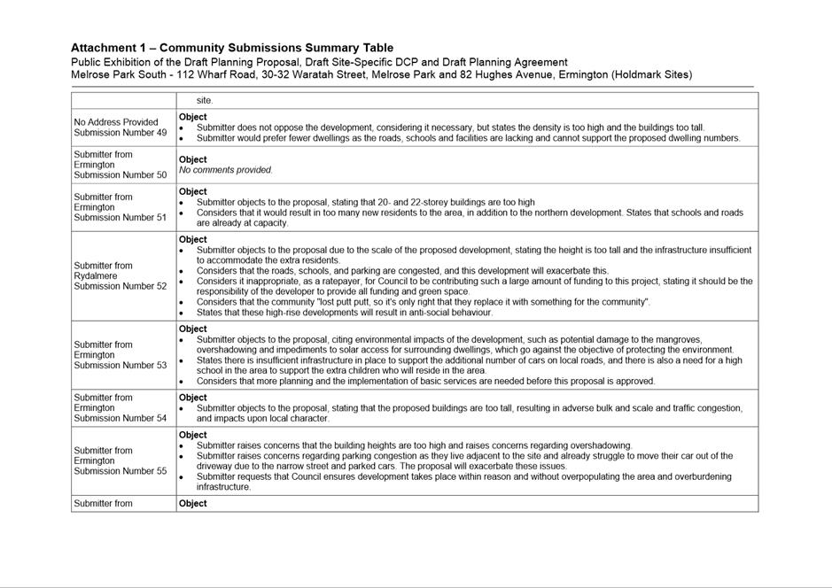
to the internal layout of the premises to facilitate its use a pub including
the insertion of a passenger lift.
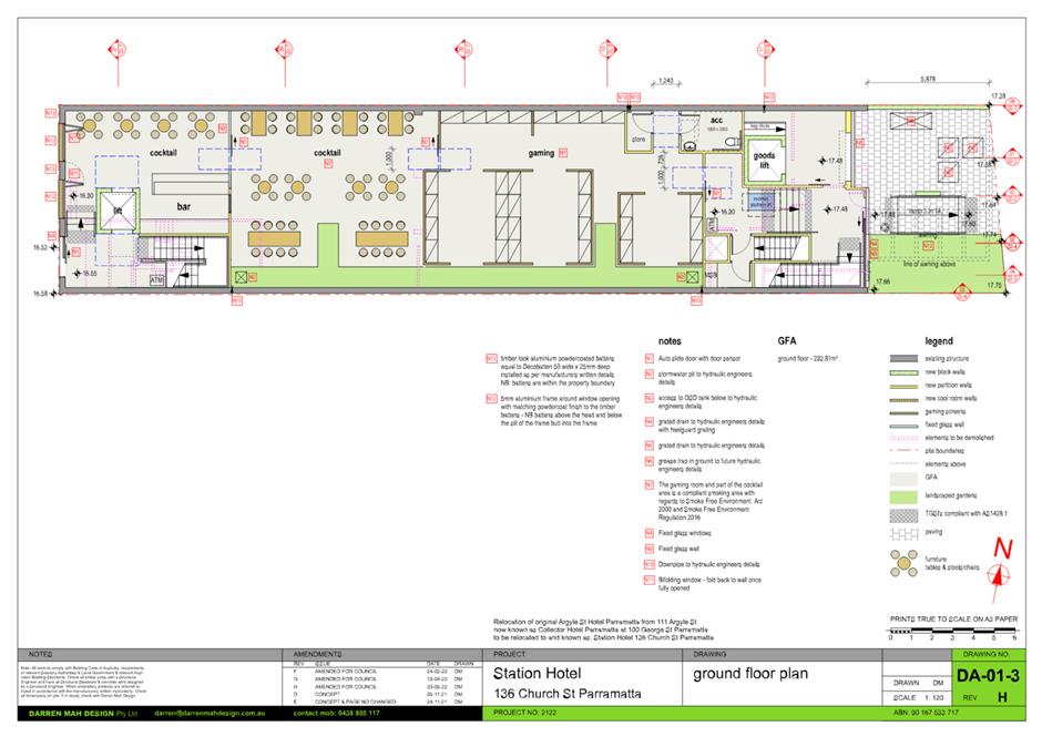
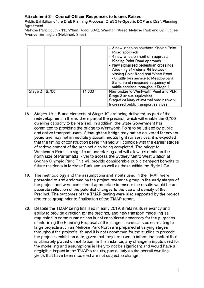
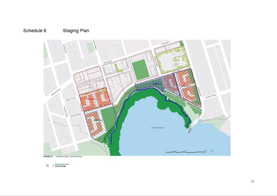
3. Additions
to the ground floor including the extension of the building to the rear (Fire
Horse Lane) and provision of a goods lift that will service the basement and
first floor.
4. Additions
to the first floor including a rear extension to facilitate the use of the
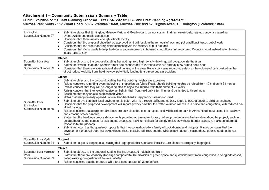
premises as a pub. This area of the pub will contain a second bar and the
dining area with an associated kitchen, amenities and balcony and;
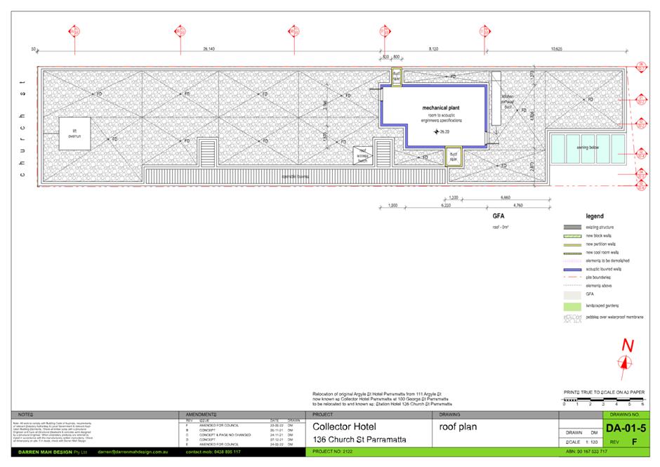
5. Creation
of a Mechanical plant room on the roof.
6. The
hours of operation of the pub are 10am to 4am Monday to Saturday and 10am to
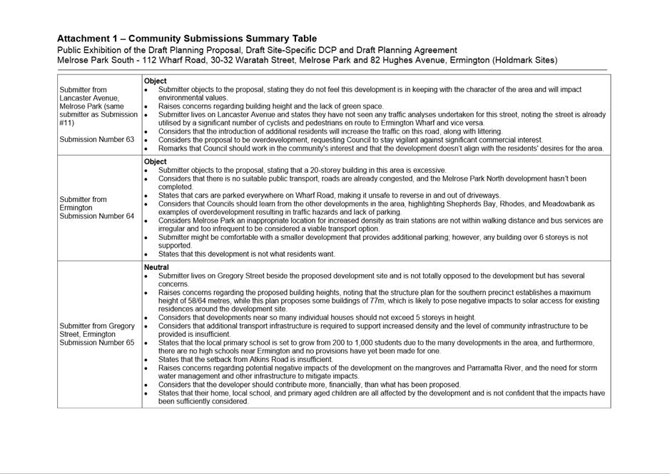
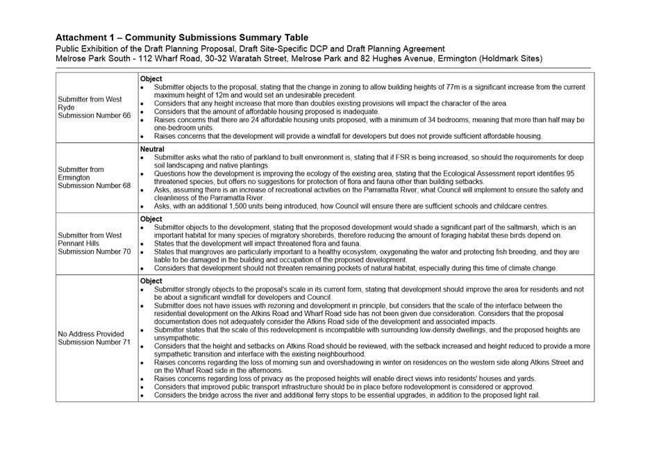
midnight Sunday.
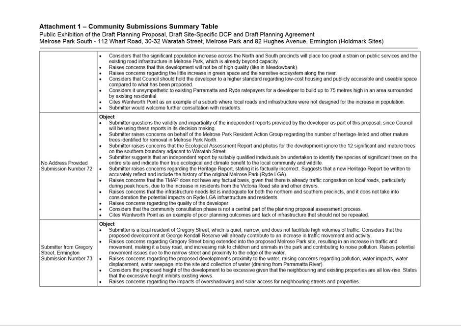
7. Approval
is sought for up to 450 patrons to be on the premises, reduced to 200 patrons
after midnight.
8. The
proposal also seeks approval for 3 x business identifications to be located on
both the front and rear facades of the building.
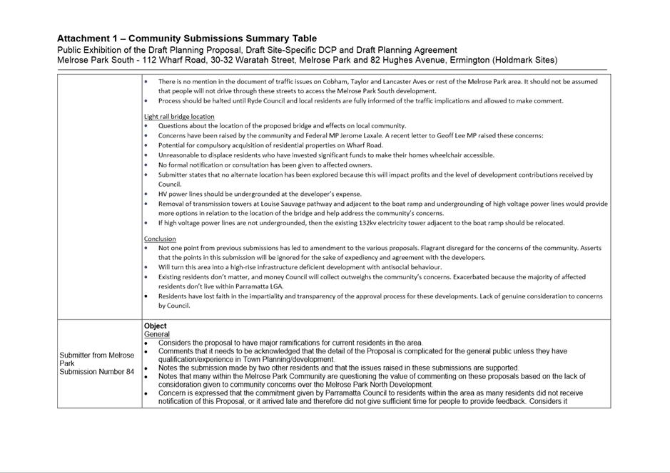
Notification
In accordance with the requirements contained within
Appendix 1 of Council’s Community Engagement Strategy, owners and
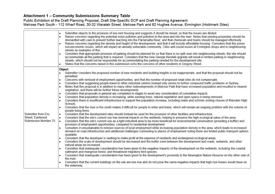
occupiers of adjoining and surrounding properties were given notice of the
application between 20 January 2022 and 11 February 2022. In response, 10
unique submissions objecting to the proposal were received. The issues raised
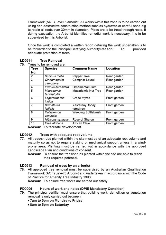
in these submissions were:
1. Increase in
anti-social behaviour;
2. Site is not
ideal location for a pub;
3. Adverse
Acoustic impacts;
4. Excessive
hours of operation;
5. Misleading
application description;
6. Details
contained in Plan of Management;
7. Street
activation;
8. Stormwater;
9. Location of
other heritage items;
10. Onsite manoeuvring;
and
11. Referral to NSW
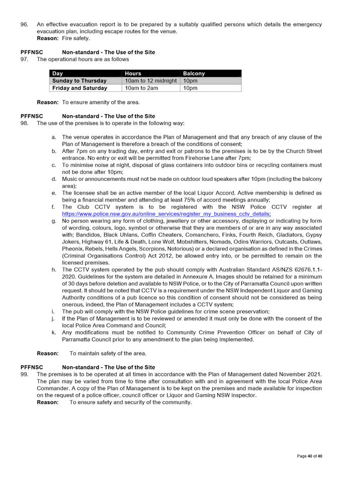
Police.
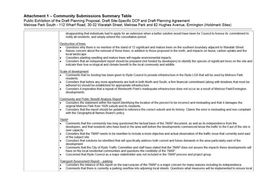
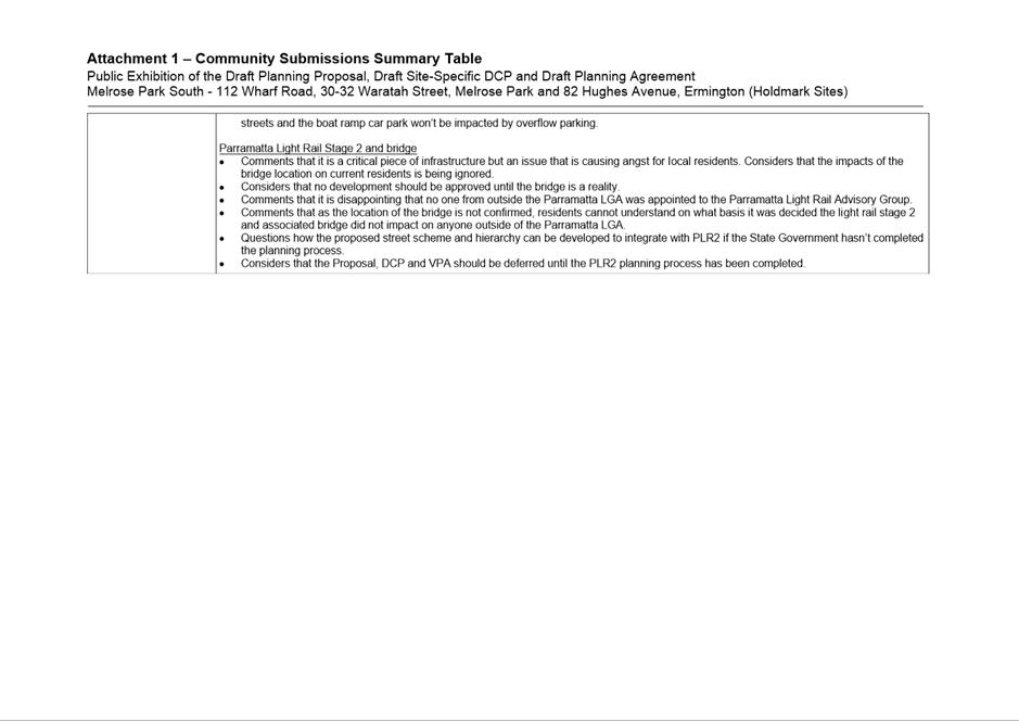
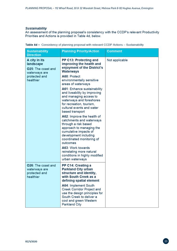
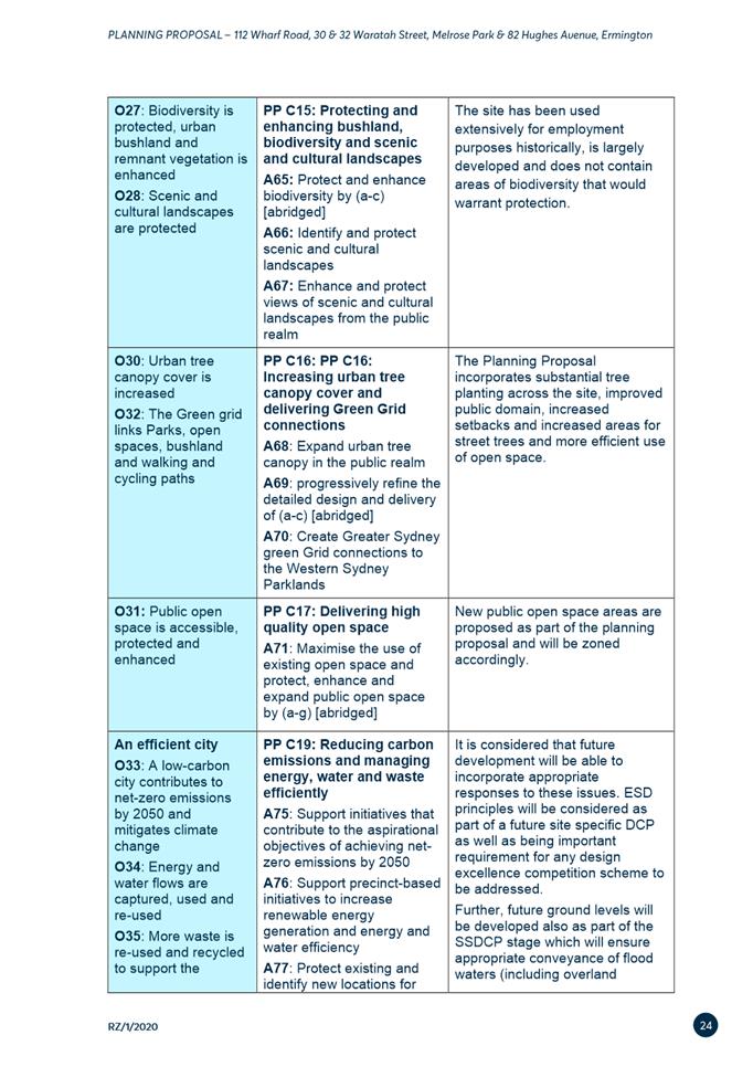
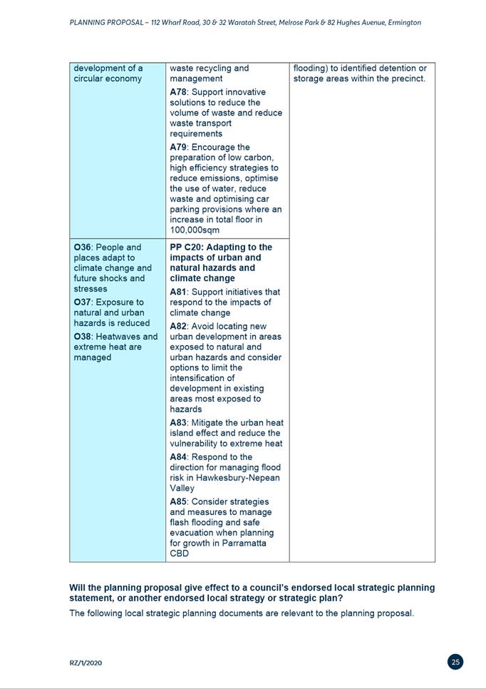
Assessment
The application is made pursuant to Parramatta Local
Environmental Plan 2011, which permits the proposed development on land within
the B4 Mixed Use zone.
The application was assessed against the
relevant environmental planning instruments, including SEPP
(Resilience and Hazards) 2021, SEPP (Biodiversity and Conservation) 2021, SEPP
(Industry and Employment) 2021 and Paramatta LEP 2011, as
well as Paramatta DCP 2011.
It is noted that the proposal is generally
compliant with the relevant planning provisions applicable to the development.
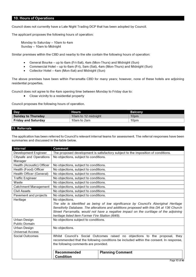
However, the hours of operation have been reduced to the following to protect
the amenity of the area.
|
Day
|
Hours
|
Balcony
|
|
Sunday to Thursday
|
10am to 12 midnight
|
10pm
|
|
Friday and Saturday
|
10am to 2am
|
10pm
|
Council’s Development Engineer,
Landscape and Tree Management Officer, Traffic and Transport Officer,
Infrastructure Officer, and Environmental Health Officer – (General
Waste, Acoustic and Contamination), catchment Management, City Safe and Operations
Manager, Civil Assets, Heritage Adviser, Urban Design (Public Domain),
Universal Access, Social Outcomes supported the development proposal, subject
to appropriate conditions. NSW Police also reviewed the proposal and raised no
objections subject to conditions.
After consideration of the development against the relevant
statutory and policy provisions, the proposal is suitable for the site and is
in the public interest.
RECOMMENDATION
(a) That,
the Parramatta Local Planning Panel, exercising the functions of Council,
pursuant to Section 4.17 of the Environmental Planning and Assessment Act
1979, grant development consent to DA/10/2022 for a period of five
(5) years within which physical commencement is to occur from the date on the
Notice of Determination, subject to conditions of consent in Attachment 1.
(b) Further, that submitters
are advised of the decision.
REASONS FOR APPROVAL
1. To
facilitate the orderly implementation of the objectives of the Environmental
Planning and Assessment Act 1979 and the aims and objectives of Parramatta
Local Environmental Plan 2011.
2. The
proposal is permissible within the B4 Mixed Use zone and is satisfactory when
considered against Section 4.15 of the Environmental Planning and Assessment
Act 1979;
3. The
development will be compatible with the emerging and planned future character
of the area; and
4. Approval
of the application is in the public interest.
Denise Fernandez
Senior Development Assessment Officer
Attachments:
|
1⇩ 
|
Assessment Report and Draft Conditions
|
40 Pages
|
|
|
2⇩
|
Locality Map
|
1 Page
|
|
|
3⇩
|
Plans used for Assessment
|
23 Pages
|
|
|
4⇩
|
Plan of Management
|
18 Pages
|
|
|
5⇩
|
Gaming Plan of Management
|
15 Pages
|
|
REFERENCE MATERIAL
Local Planning Panel 15 November 2022 Item
6.1
ITEM NUMBER 6.1
SUBJECT Exhibition Outcomes - Draft Planning Proposal, Draft Site-Specific
DCP and Draft Planning Agreement - Holdmark Sites (Melrose Park South)
REFERENCE RZ/1/2020 -
APPLICANT/S Holdmark Property Group
OWNERS Holdmark Property Group
REPORT OF Senior Project Officer
Development
applications considered by Sydney central city planning panel Nil
PURPOSE
The purpose of this report is to detail
submissions received during the public exhibition of the Planning Proposal,
draft Site-Specific Development Control Plan (DCP) and draft Planning Agreement
and to respond to issues raised, relating to two (2) sites in the southern
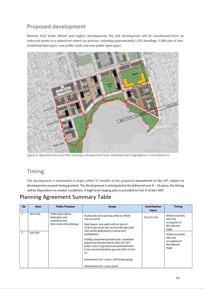
precinct of Melrose Park identified as the East Site (112 Wharf Road, 30 and 32
Waratah Street, Melrose Park) and West Site (82 Hughes Avenue, Ermington). The
report recommends that the updated Planning Proposal, draft Site-Specific DCP
and updated draft Planning Agreement be approved by Council.
RECOMMENDATION
That the
Parramatta Local Planning Panel consider the following Council Officer
recommendation in its advice to Council:
(a) That Council receives and notes the submissions made during the
exhibition of the Planning Proposal, draft Site-Specific Development Control
Plan (DCP), and draft Planning Agreement (Attachment 1) and Council
officer responses to the issues raised (Attachment 2).
(b) That Council approve the updated Planning Proposal for
finalisation (provided at Attachment 3) that seeks to amend Parramatta
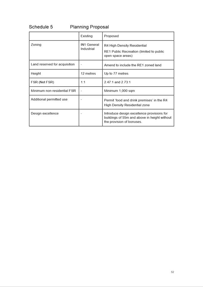
Local Environmental Plan 2011 as follows:
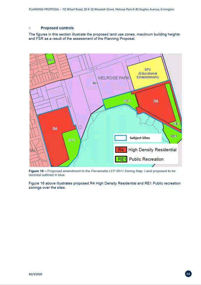
1. Rezone 112 Wharf Road, 32 Waratah Street,
Melrose Park and 82 Hughes Avenue, Ermington from IN1 General Industrial to
part R4 High Density Residential and part RE1 Public Recreation.
2. Rezone 30 Waratah Street, Melrose Park from IN1
General Industrial to RE1 Public Recreation.
3. Amend the maximum building height on the East
Site and West Site from 12m to a combination of 25m (6 storeys), 34m (8
storeys), 68m (20 storeys, and 77m (22 storeys) on each site.
4. Amend the Floor Space Ratio
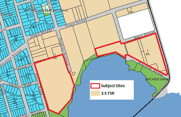
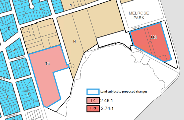
on the East Site from 1:1 to 2.74:1 (net).
5. Amend the Floor Space Ratio on the West Site from 1:1 to 2.46:1
(net).
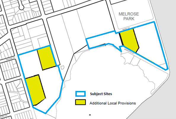
6. Insert a site-specific provision in Part 6 additional local
provisions – generally of Parramatta Local Environmental Plan 2011 and
amending the Additional Local Provisions map to include the East Site and West
Site to ensure:
6.1 That design excellence
provisions be applicable to buildings with a height of 55m and above and
appoint a Design Excellence Panel
to provide design advice for all development applications within the subject
sites. Floor Space Ratio and height of building bonuses are not to be awarded
on any development lot.
6.2 A minimum of 1,000m2 of
non-residential floor space is to be provided across the East and West Sites to
serve the local retail and commercial needs of the incoming population.
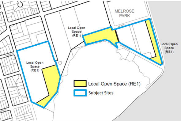
7. Amend the Land Reservation Acquisition map to
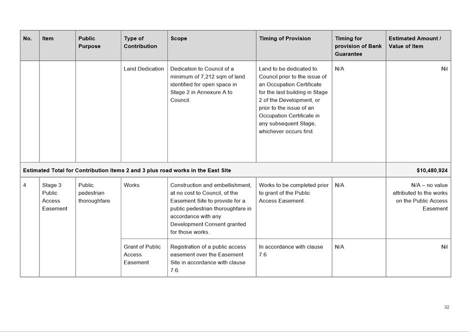
reflect areas of open space to be dedicated to Council.8) Insert
provisions into the Parramatta
Local Environmental Plan 2011
to ensure that the number of dwellings approved at the development application
stage aligns with the required infrastructure identified by Council in the
Transport Management and Accessibility Plan (TMAP).
8. Insert provisions into the Parramatta Local Environmental Plan 2011 requiring the Planning Secretary to be satisfied that all
State public infrastructure needs (including transport and schools) are met
before development can proceed.
9. Insert provisions into Parramatta Local Environmental Plan 2011 to ensure that the new planning controls do not
take effect on the subject sites prior to the local infrastructure identified
in the local Planning Agreement being secured by way of an executed Planning
Agreement between Council and the Applicant.
10. Amend Schedule 1 Additional Permitted Uses of Parramatta
Local Environmental Plan 2011 to
permit ‘food and drink’ premises in the R4 High Density Residential
zone as identified on the new Additional Permitted Uses map.
(c) That Council forward the Planning Proposal to the Department of
Planning and Environment for finalisation.
(d) That Council approve the Site-Specific DCP at Attachment 4.
(e) That Council approve the Planning Agreement at Attachment 6 and
the Chief Executive Officer be authorised to sign the Planning Agreement on
behalf of Council.
(f) Further,
that Council authorises the Chief
Executive Officer to make any minor amendments and corrections of a non-policy
and administrative nature that may arise during the finalisation of the
Planning Proposal, DCP and Planning Agreement.
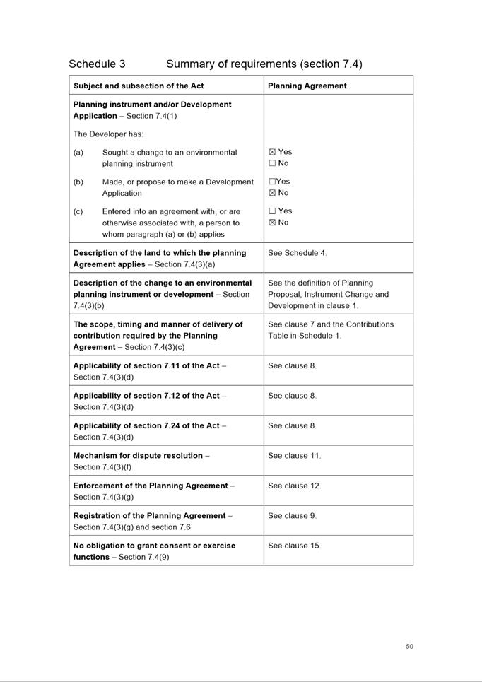
PLANNING PROPOSAL
TIMELINE
SUMMARY
1. This report
seeks the Local Planning Panel’s (LPP) advice on a recommendation for
Council to consider the outcomes of the public exhibition of the Planning
Proposal, draft Site-Specific DCP and draft Planning Agreement relating to two
(2) sites within the southern precinct of Melrose Park (East Site and West
Site).
2. The Planning
Proposal seeks to amend the Parramatta Local Environmental Plan 2011 (PLEP
2011) to enable non-industrial development on the abovementioned sites in
the form of high density residential, public open space, and small-scale
retail/commercial uses. This Proposal is generally in accordance with the
Southern Structure Plan adopted by Council in December 2019. Should the
Planning Proposal and draft DCP be approved, approximately 1,925 new dwellings
could be delivered across the two subject sites.
3. The Planning
Proposal, draft DCP and Planning Agreement were placed on public exhibition
from 25 August 2022 to 21 September 2022. Eighty-five (85) submissions were
received comprising seventy-nine (79) from the
community, with the remaining 6 from public agencies and other organisations.
Overall, 3% of submissions were in
support and 77% objected to the Proposal with the remaining 20% neither
objecting nor supporting the Proposal. A summary of the
key issues raised is provided later in this report, with further details and
responses provided at Attachment 2.
4. The key issues raised in submissions relate to building heights,
infrastructure provision, potential traffic impacts and character loss. With
regards to building heights, the proposed heights are the result of detailed
urban design testing and are compatible with the adopted building heights in
the Melrose Park North precinct and will be consistent with the established
future character of the area. In relation to concerns about increases in traffic,
the proposed road upgrades and public transport improvements including a bridge
connection over Parramatta River will ensure any impacts can be managed. The
infrastructure identified to be provided as part of the Planning Proposal is
consistent with the identified needs of the precinct and is considered
appropriate. These matters can be further considered at the development
application stage, which will be addressed by the controls within the PLEP 2011
and draft Melrose Park South DCP.
5. The matters raised in the submissions do not necessitate changes to
the Planning Proposal, draft DCP and draft Planning Agreement. Minor changes are however proposed to the
exhibited Planning Proposal to reflect the post-exhibition Gateway conditions
and these changes are detailed within Table 2.
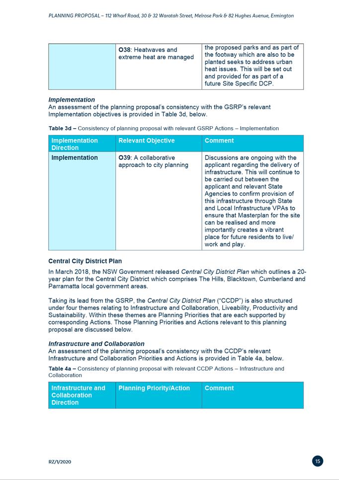
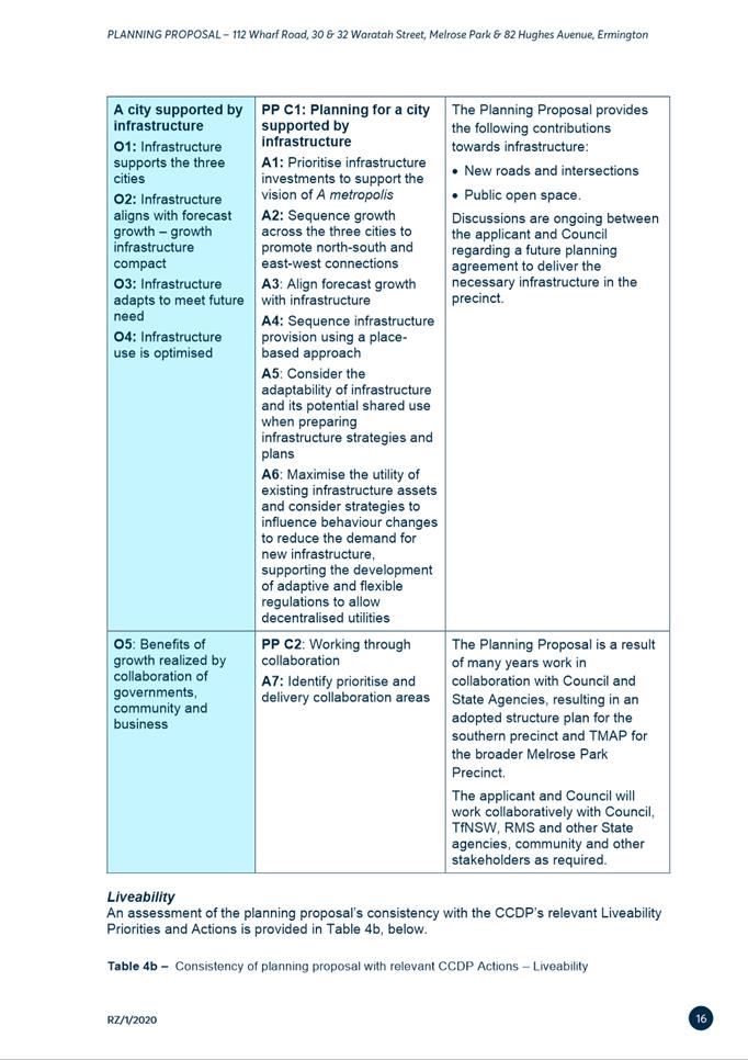
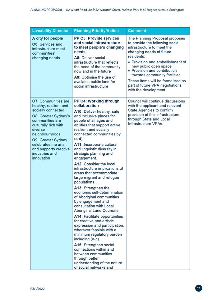
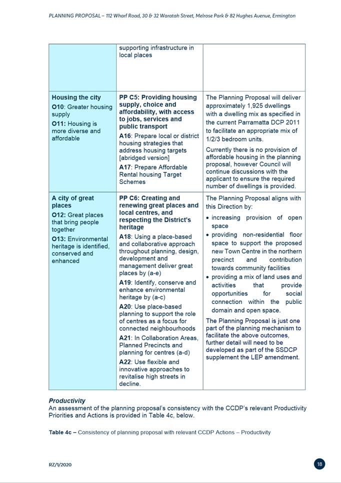
BACKGROUND
6. Council
adopted the Parramatta Employment Lands Strategy (ELS) at its meeting of 11
July 2016, which identified the Melrose Park industrial area precinct as being
a Structure Plan precinct and suitable for redevelopment for non-industrial
uses.
7. In May 2016, a Planning Proposal was lodged for the Holdmark East
site, however this was not progressed due to the requirement within the adopted
ELS to first prepare a structure plan for the precinct before any Planning
Proposals could be progressed. This Planning
Proposal was subsequently placed on hold until the Southern Structure Plan
process was complete.
8. A draft Southern Structure Plan was submitted by the Applicant for
the southern part of the Melrose Park precinct in November 2017, which was
subject to extensive review and refinement over the course of 2018 and early
2019. Council endorsed the draft Southern Structure Plan for public exhibition
on 24 June 2019 and it was exhibited from 14 August to 10 September 2019. Following exhibition, a
revised version of the draft Southern Structure Plan (Attachment 5) was
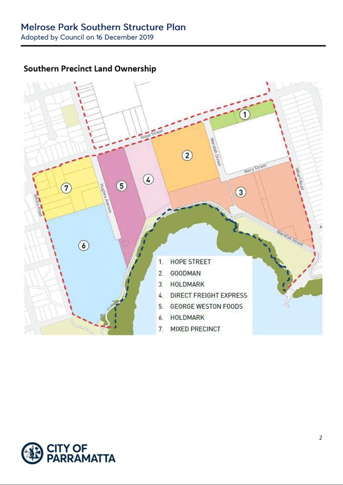
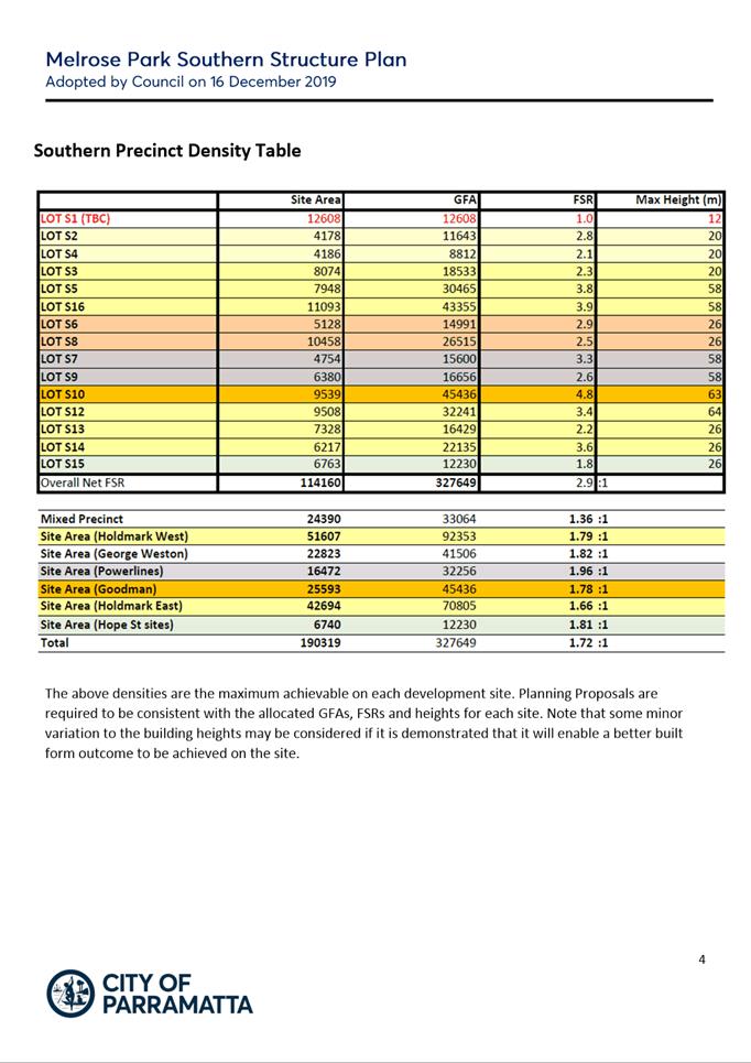
considered and adopted by Council on 16 December 2019.
9. Adopted by Council on 23 March 2020, City of Parramatta’s
Local Strategic Planning Statement (LSPS) sets out Council’s 20-year
vision for land use and infrastructure in the City of Parramatta. Melrose Park is identified as a Local Centre within the LSPS and is
therefore suitable for high density residential development. The LSPS
recognises that Melrose Park could provide over 2,000 jobs once redeveloped and
identifies the need for improved public transport. As Melrose Park is
identified as a Growth Precinct and the Planning Proposal will help deliver
housing and infrastructure needs, it aligns with the vision of the LSPS.
10. The
Applicant lodged a revised Planning Proposal with Council on 11 May 2020
reflecting the requirements of the adopted Southern Structure Plan and
incorporating an additional site at 82 Hughes Avenue. The revised Planning
Proposal was considered by the LPP on 29 September 2020 and the LPP unanimously
supported the recommendation of the report. Council endorsed the Planning
Proposal to proceed to the Department of Planning and Environment (DPE) for
Gateway Determination on 9 November 2020.
11. A
Gateway determination was issued by DPE on 17 August 2021 requiring the
Planning Proposal to be submitted to DPE by 30 June 2022 for finalisation to
occur by 31 August 2022.
12. A
report on the draft Site-Specific DCP and draft Planning Agreement was
considered by Council on 28 March 2022, where both documents were endorsed to
proceed to public exhibition. After this time, Council officers undertook
further discussions with the proponent regarding the finer details of the
clauses within the Planning Agreement, which took several months to resolve.
13. A
Gateway Alteration was issued by DPE on 12 September 2022 granting an extension
until 24 December 2022 for the Planning Proposal to be submitted to DPE for
finalisation.
14. The draft Planning
Proposal, draft Site-Specific DCP and draft Planning Agreement were publicly
exhibited from 25 August to 21 September 2022.
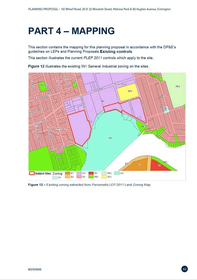
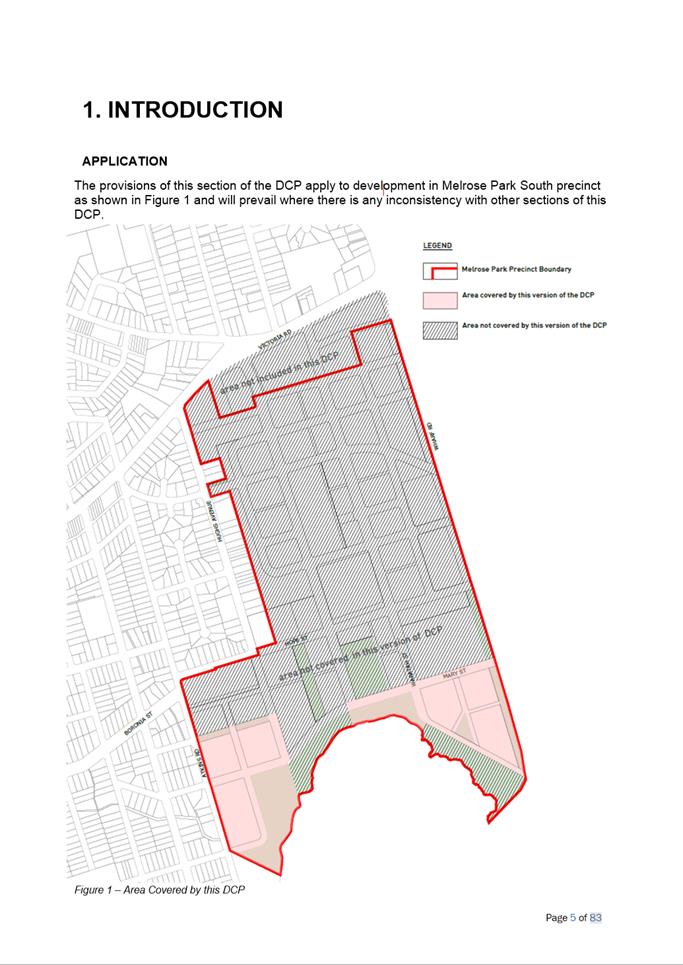
SITE DESCRIPTION
15. The southern precinct is
bound by Hope Street to the north, Wharf Road to the east, Parramatta River to
the south and Atkins Road to the west. It is located approximately 6km east of
the Parramatta CBD and adjoins the Ryde Local Government Area (LGA) to the
east. The proposed Parramatta Light Rail Stage 2 (PLR2) corridor runs through
the precinct along Hope Street before turning south onto Waratah Street and
over the proposed bridge connecting to Wentworth Point.
16. The sites subject to this
Planning Proposal are located on the eastern and western sides of the southern
precinct. The East Site, which relates to 112 Wharf Road and 30 and 32 Waratah
Street is approximately 42,692m2 (4.2ha) and is located to the south
of Melrose Park Public School. The West Site is approximately 51,607m2
(5.1ha) and bound by Hughes Avenue to the east, Parramatta River to the south,
Atkins Road to the west and 71 Atkins Road and 80 Hughes Avenue along the
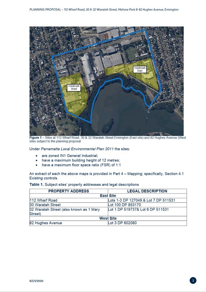
northern boundary. These sites are referred to as “East” and
“West” respectively in this report (see Figure 1). These two
sites comprise of approximately 9.4ha of the 19ha southern precinct, which
equates to approximately 49% of the land area under Holdmark’s ownership
17. The sites are currently
largely developed and occupied by a variety of industrial premises. The East
Site comprises pharmaceutical, engineering and plastics manufacturing. The West
Site comprises purpose-built pharmaceutical manufacturing buildings.
Surrounding land uses comprise low density residential in both the Parramatta
(west) and Ryde LGAs (east), Parramatta River to the south and industrial land
between both sites.
18. There are currently no
Planning Proposals lodged with Council for the remaining industrial sites
within the southern precinct. As a result, it is difficult to provide a
timeframe for when the remainder of the southern precinct will be redeveloped.
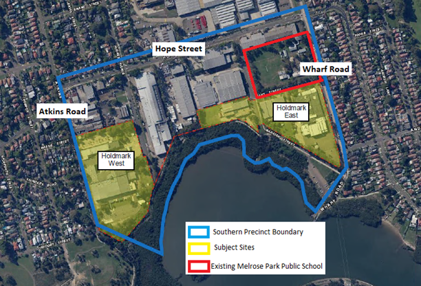
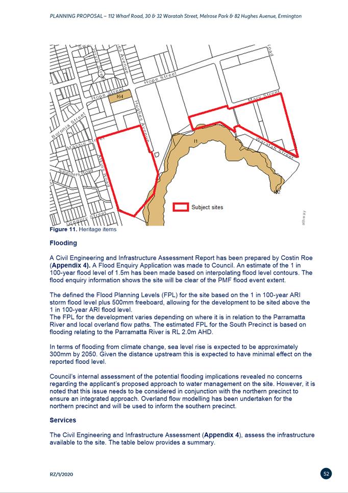
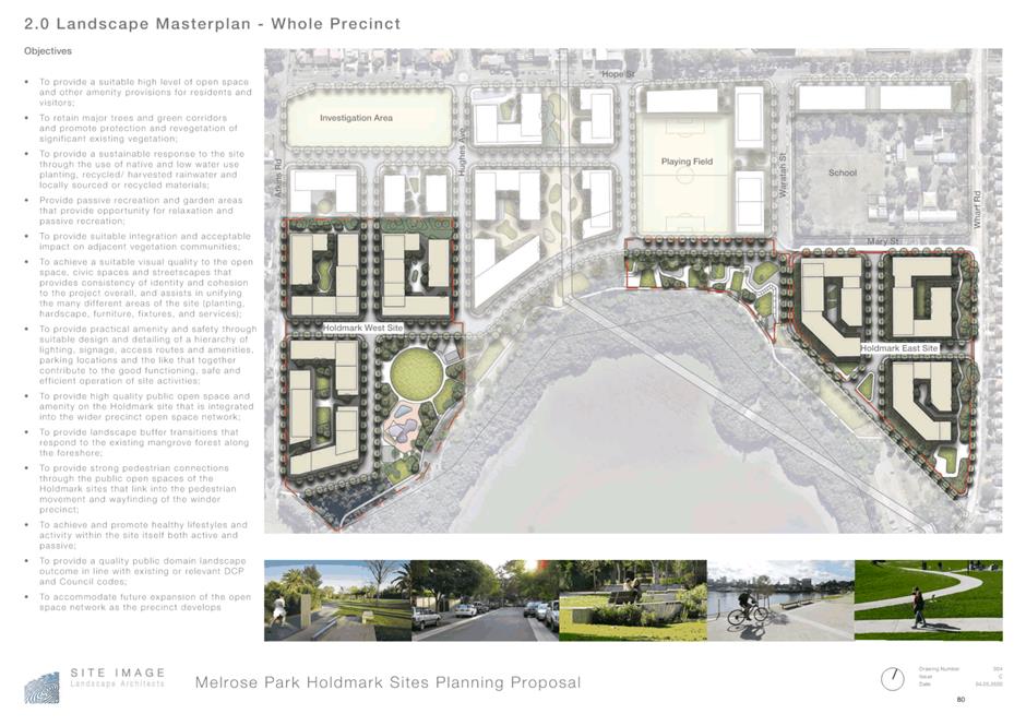
Figure 1. Sites subject to this Planning Proposal
OVERVIEW OF THE
PLANNING PROPOSAL
19. The Planning Proposal
seeks to amend PLEP 2011 to enable redevelopment for high density residential,
public open space and some small-scale retail/commercial uses on the two sites.
Refer to Table 1 below for a summary of the existing and proposed
controls.
20. Specifically, the Planning
Proposal also seeks the following amendments:
Amend Schedule 1 Additional Permitted Uses of PLEP 2011 to
permit ‘food and drink premises’ in the R4 High Density Residential
zone. The intention of this amendment is to enable street-level activation by
allowing restaurants and cafes to operate on the ground floor of buildings.
Amend the Land Reservation Acquisition map to reflect areas
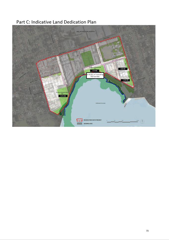
of open space to be dedicated to Council.
Insert provisions into PLEP 2011 similar to those utilised
for the Melrose Park North amendment to ensure that consideration is given to
the State infrastructure, including schools, required to serve the precinct
relative to the number of dwellings proposed when development applications are
determined.
Insert provisions in PLEP 2011 to ensure that the new
planning controls do not take effect on the subject sites prior to the local
infrastructure identified in the local Planning Agreement being secured. It is
envisaged that the mechanism will be via a deferred commencement clause as was
done with the Melrose Park North amendment.
Insert a site-specific provision in Part
6 additional local provisions – generally of PLEP 2011 amending
the Additional Local Provisions map to include the land to ensure:
- That design excellence provisions be
applicable to buildings of 55m and above in height and appoint a Design Excellence Panel to provide design advice
for all development applications within the subject sites. Floor space and
height bonuses are not to be awarded on any development lot.
- A minimum of 1,000m2 of non-residential floor
space is to be provided within the subject sites to serve the local retail and
commercial needs of the incoming population.
Table 1. Summary of current and proposed planning
controls on the subject sites
|
|
EAST
SITE
|
WEST SITE
|
|
|
112 Wharf Road
|
30 Waratah Street
|
32 Waratah Street
|
82 Hughes Avenue
|
|
Current Zone
|
IN1
General Industrial
|
|
Proposed Zone
|
Part R4 High Density
Residential, part RE1 Public Recreation
|
RE1 Public Recreation
|
Part R4 High Density
Residential, part RE1 Public Recreation
|
Part R4 High Density
Residential, part RE1 Public Recreation
|
|
Current FSR
|
1:1
|
1:1
|
|
Proposed FSR
(gross)
|
1.66:1
|
1.78:1
|
|
Proposed FSR (net)
|
2.74:1
|
2.46:1
|
|
Current height
limit
|
12m
|
12m
|
|
Proposed Height
|
Ranging
between 6 storeys (25m), 8 storeys (34m), 20 storeys (68m) and 22 storeys
(77m)
|
|
Potential dwelling
yield per site
|
835 dwellings
|
1,090 dwellings
|
|
Combined potential
dwelling yield
|
1,925 dwellings
|
|
Non-residential
floor space component
|
500m2
|
500m2
|
21. Refer to Figures 2 to 7 showing the
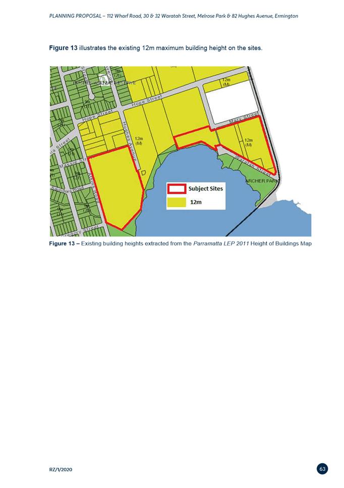
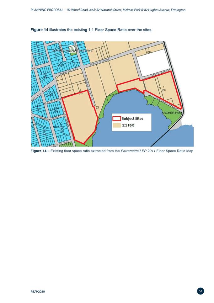
current and proposed zones, height of buildings and FSR controls. Figure 8
shows the proposed Additional Local Provisions location, Figure 9 shows
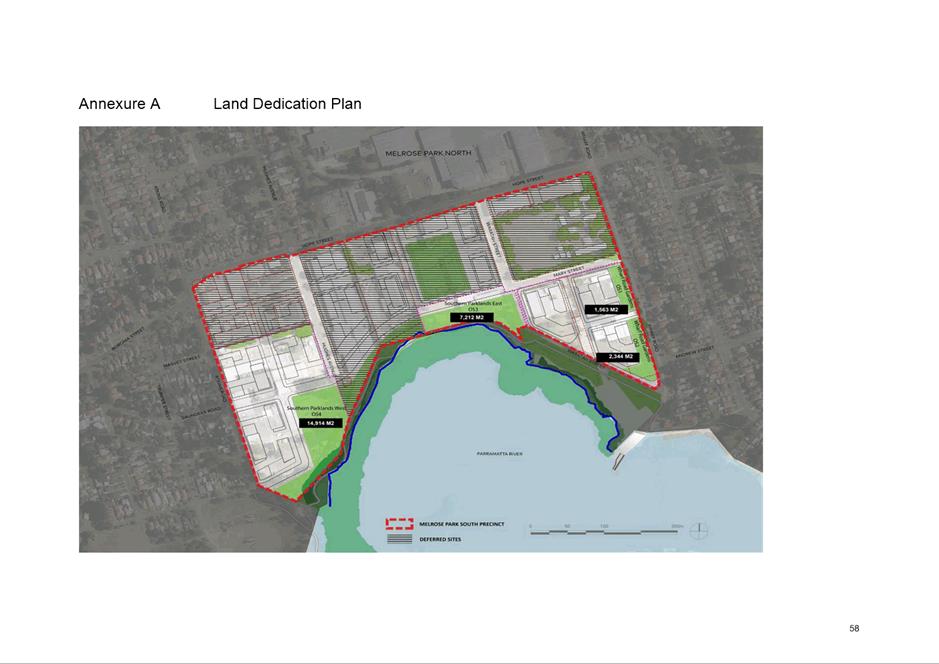
the proposed land reserved for dedication to Council (at no cost as per
Planning Agreement) and Figure 10 shows the proposed Additional
Permitted Uses location.
|
|
|
Figure 2. Current land use zones applicable on the
subject sites
|
|
|
|
Figure 3. Proposed land use zones on the subject sites
|
|
|
|
Figure 4. Current maximum height of building applicable
on the subject sites
|
|
|
|
Figure 5. Proposed height of buildings on the subject
sites
|
|
|
|
Figure 6. Current FSR applicable on the subject sites
|
|
|
|
Figure 7. Proposed FSRs on the subject sites
|
|
|
|
Figure 8. Proposed location of Additional Local
Provisions (design excellence competition)
|
|
|
|
Figure 9. Land subject to dedication to Council
|
|
|
|
Figure 10. Proposed location of Additional Permitted
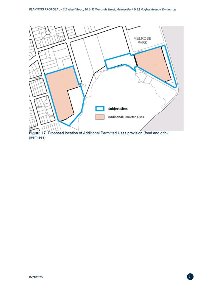
Uses provision (food and drink premises)
|
PLANNING PROPOSAL
CHANGES
22. No changes to the intended
outcomes are proposed to the Planning Proposal as a result of the public
exhibition. However, several minor amendments have been made to reflect the
conditions of the Gateway determination. These changes are identified in Table 2 below. Two mapping changes have been made to better
identify the land subject to the proposed additional permitted use and
additional local provisions. These include:
i. Updating the Additional Local Provisions map (Figure 8) which now identifies the land subject to design
excellence competition provisions requiring buildings of 55m and above to be
subject to a design excellence competition and that all development
applications on the East Site and West Site be subject to review by the Design
Excellence Panel.
ii. Creation
of an Additional Permitted Uses map (Figure 10)
to identify the expanded area subject to the proposed additional permitted use
of ‘food and drink premises’.
23. The ‘food and drink
premises’ use was initially envisaged to be permissible only along the
waterfront of Parramatta River but has been revised to enable the use to be
permissible anywhere within the R4 High Density Residential zone. This is to
ensure greater flexibility and to be consistent with the Council resolution
from 9 November 2020 that endorsed the submission of the Planning Proposal for
Gateway determination. It is noted that the future fit out and use of these
premises will be subject to detailed impact assessment at the development application
stage.
Table 2. Changes to the Planning Proposal
|
POST-EXHIBITION
GATEWAY CONDITIONS
|
|
Condition
|
Action
|
|
a)
|
ensure
endorsement of the Parramatta Employment Land Study and alignment with the
planning proposal outcomes;
|
The Parramatta Employment Land Study is
currently with DPE for endorsement; however, no timeframe has been provided
as to when endorsement may occur. Following advice from DPE, a statement has
been included in Section 3.1.1 of the Planning Proposal outlining how the
Proposal responds to the requirements of the Employment Lands Study.
|
|
b)
|
further
consideration of how the planning proposal aligns with the broader Melrose
Park precinct in terms of implementation and delivery of infrastructure to
ensure the orderly development of land
|
As experienced in the finalisation of the
Melrose Park North Planning Proposal, it is not possible to dictate the order
in which redevelopment of land occurs within the Melrose Park Precinct.
However, the local Planning Agreement (refer to summary later in this report)
includes a staging plan in the Infrastructure Services Delivery Plan
identifying at which stage of redevelopment the identified infrastructure
items are required to be delivered. This ensures that the infrastructure
required to support the incoming population is delivered at the appropriate
stag of redevelopment. This has been inserted into Section 10.1.1 of the
Planning Proposal.
|
|
c)
|
consistency
with section 9.1 Direction 1.1 Business and Industrial Zones and Central City
District Plan Planning Priority C11;
|
Additional explanation has been included
in Section 3.2.3 of the Planning Proposal detailing consistency with this
Direction and Priority.
|
|
d)
|
ensure
there is a mechanism in place for the delivery of local and State
infrastructure required to support the anticipated growth;
|
Text has been inserted in Section 1.1 of
the Planning Proposal indicating that the intended mechanism to meet this
condition is via the requirement of the proponent to enter into Planning
Agreements with both Council and the State Government to secure applicable
contributions towards the delivery of local and State infrastructure.
It is anticipated that a concurrence
clause will be inserted into PLEP 2011 relating to the timing of development
and State infrastructure delivery such as significant road works and schools.
This approach was taken for the Melrose Park North Planning Proposal
The draft local Planning Agreement
includes a staging plan in the Infrastructure Services Delivery Plan
identifying at which stage of redevelopment the identified infrastructure
items are required to be delivered.
In addition, Council’s officers
will recommend to DPE that a provision be inserted into PLEP 2011 that
specifies a date to which the new controls come into effect. This approach
was taken with the Melrose Park North Planning Proposal to ensure the local
Planning Agreement is finalised and registered before any redevelopment of
the site seeking to utilise the new controls could occur.
|
|
e)
|
ensure
that the land is suitable for the intended land uses with regard to
high-pressure pipeline safety risk with a hazard assessment against the
relevant legislation and policies.
|
A Hazard Analysis
Report was prepared during the preparation of the Melrose Park North Planning
Proposal to address DPE’s and School Infrastructure NSW’s
concerns about the proximity of the Viva high pressure oil pipeline to the
new school site in the northern precinct. This report covers the entire
Melrose Park precinct and concludes
that the maximum individual fatality risk only occurs at two locations where
the Gore Bay Pipeline changes direction and would only apply to sensitive
land uses (schools, hospitals, etc.). These uses are not currently proposed
on the subject sites. Therefore, the proposed redevelopment satisfies the
individual fatality risk criteria.
Despite
the report concluding that there is no risk to the subject sites, the report
does recommend several measures, many of which relate to sensitive land uses
such as hospitals, aged care facilities and child care centres. The remaining recommendations are in relation to the
detailed design of the future buildings within the precinct.
Given
the Proposal is still at rezoning stage, the Arriscar report is sufficient to
satisfy item 5 (e) of the Gateway Determination. Further studies will be
undertaken at Development Application and Construction Certificate stage once
the use and design of each individual building is known. This has been
inserted into Section 3.2.2 of the Planning Proposal.
|
OVERVIEW OF THE
DRAFT DEVELOPMENT CONTROL PLAN
24. The
LEP is a higher-order planning instrument than the DCP and contains the
overarching planning provisions such as the zoning, height of buildings and
floor space ratio. The Draft Site-Specific DCP supports the provisions
within the LEP by providing detailed development controls relating to design,
character, and the environment to ensure the desired outcome for the site is
achieved. The draft Site-Specific DCP was endorsed by Council for public
exhibition on 28 March 2022 provides specific development requirements for the
Melrose Park South precinct and is required to be consistent with the new LEP
controls that are set by the Planning Proposal.
25. The
Melrose Park South Site-Specific DCP (refer to Attachment 4) has been
drafted using the Melrose Park North DCP (adopted by Council on 11 October
2021) as a template with changes made where necessary to respond to the context
of the southern precinct. As with the north, a collaborative approach has been
taken in working with the proponent to finalise the draft DCP.
26. The
draft DCP reflects and is consistent with the key development standards and
desired outcome of this Planning Proposal.
Primary DCP
Objectives
27. The
draft DCP will guide development and contain specific requirements that must be
addressed during the design stage of the planning process and future
development applications, having regard to the location within an identified
Growth Precinct, the local context and detailed design requirements for the two
sites. The detailed design requirements are grouped into five (5) main parts,
being:
i. Introduction
ii. Built Form
iii. Public Domain
iv. Vehicular Access, Parking and Servicing
v. Sustainability
28. These parts contain
multiple sub-sections that include detailed controls, such as:
|
·
General objectives
and principles
|
·
Solar
access
|
|
·
Allocation of gross
floor area (building envelopes)
|
·
Dwelling
mix
|
|
·
Setbacks
|
·
Desired
future character
|
|
·
Street and block
layout
|
·
Open
space
|
|
·
Tower design
|
·
Parking requirements
|
|
·
Ground floor frontage
|
·
Stormwater
management
|
29. A
key consideration when drafting the DCP controls was to ensure that the best
possible amenity in the precinct could be achieved for the future residents,
visitors, and existing neighbours in the surrounding low density residential
areas. The draft DCP underpins and relates to the site configurations and
building envelopes identified in the Southern Structure Plan (refer to Attachment
5) and the Planning Proposal to achieve the FSRs and building heights adopted by Council for these sites and the broader southern
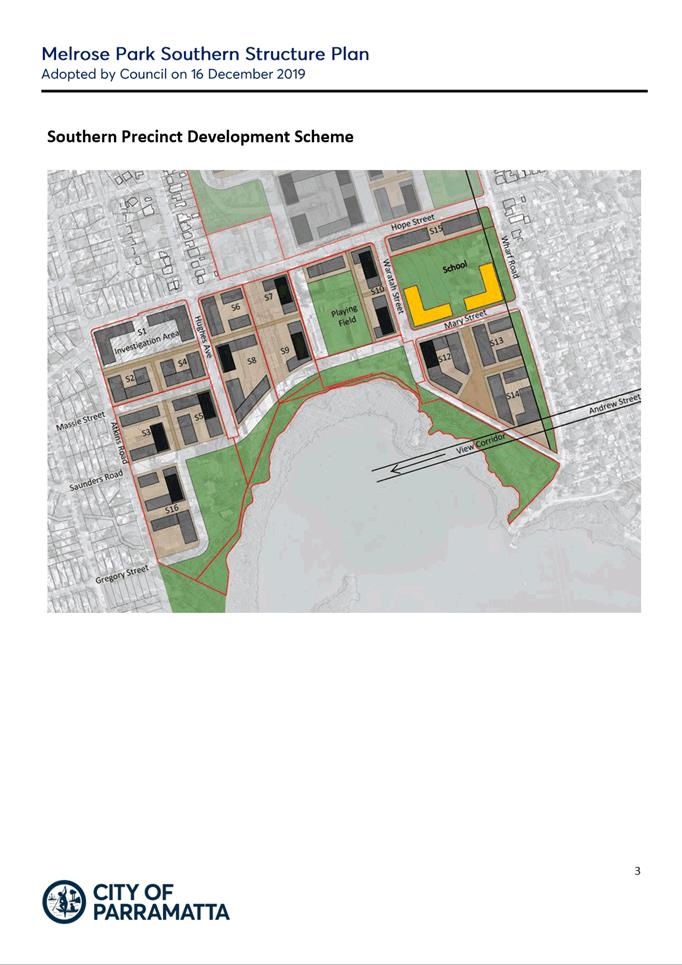
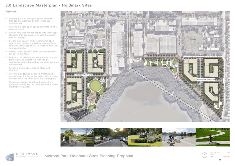
precinct. The current scheme is shown in Figure 9 below.
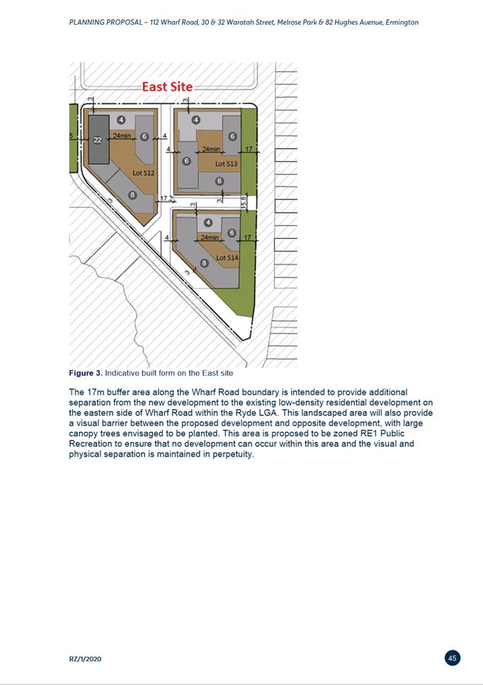
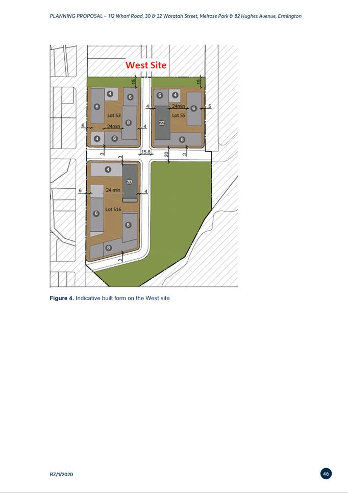
Figure 9. Proposed scheme on the East Site and West Site
30. Although several submissions raised matters relating to the
draft DCP, including road carriageway requirements and the effectiveness of the
design controls, these concerns are considered to be addressed by the proposed
controls. Details of these matters and Council officer responses are provided
at Attachment 2.
31. A concern was raised in a submission relating to the
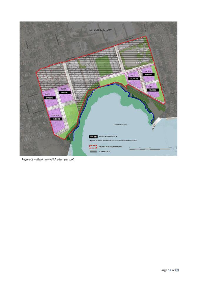
indicative gross floor area map contained at Figure 2 on page 14 of the draft
DCP, and the distribution of non-residential gross floor area between the East
Site and West Site. Figure 2 only provides for a maximum residential gross
floor area and does not include the minimum 1,000m2 non-residential
gross floor area that is required by the draft LEP provisions. Council officers
have since confirmed that Figure 2 included the residential and non-residential
gross floor area as part of the residential gross floor area figure. Therefore,
it is recommended that the legend be updated to refer to the combined
residential and non-residential gross floor area (refer to Figure 10
below). The distribution of residential and non-residential gross floor area
will be considered further at the development application stage.
Figure 10. Updated Figure 2 referring to combined residential and
non-residential GFA
OVERVIEW OF THE DRAFT PLANNING AGREEMENT
32. The draft Planning
Agreement relating to the provision of local infrastructure has a total value
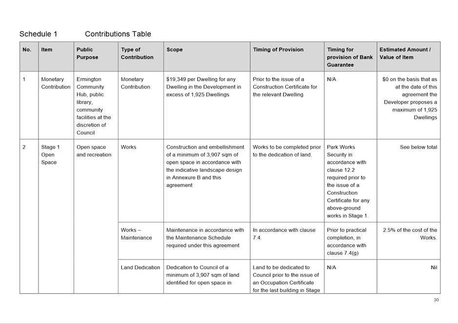
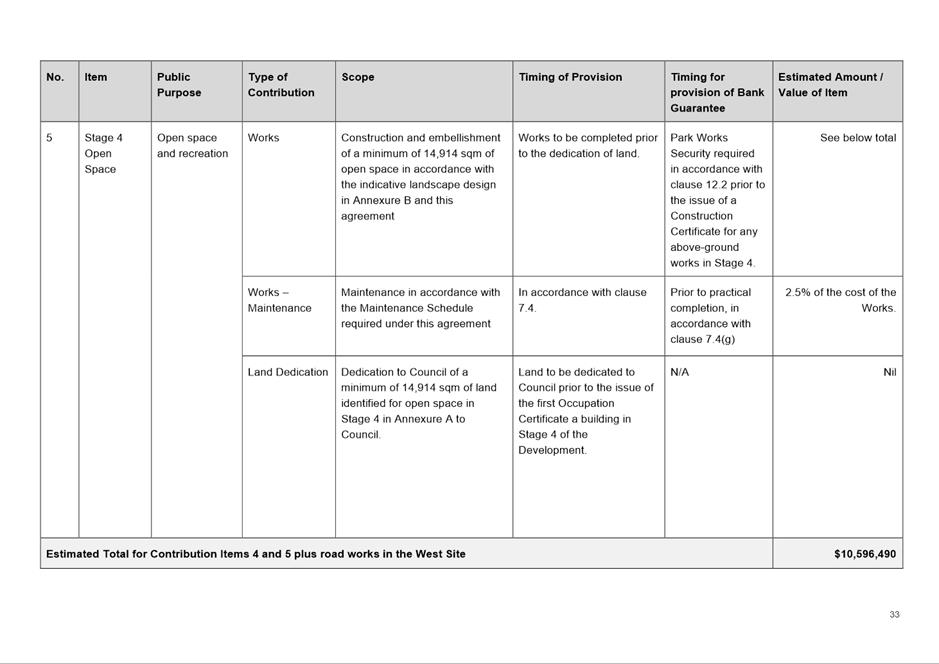
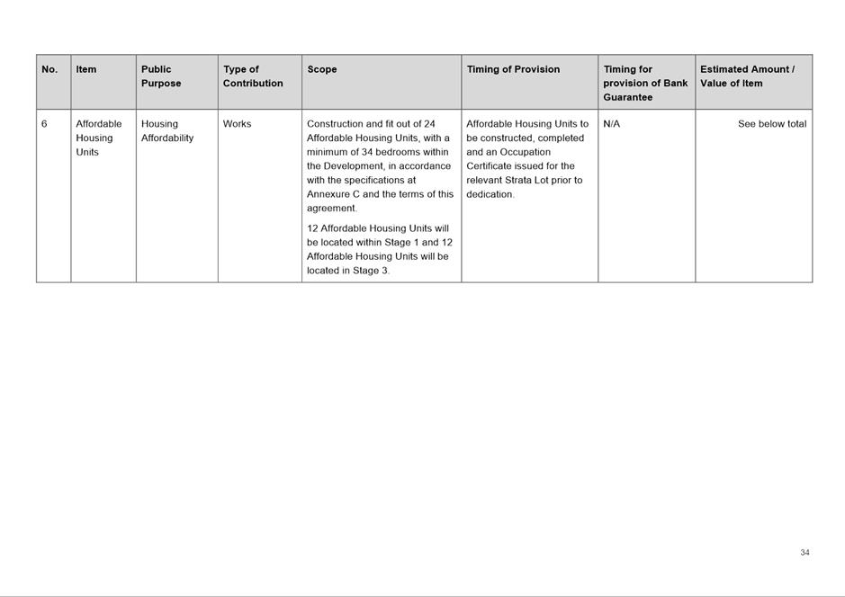
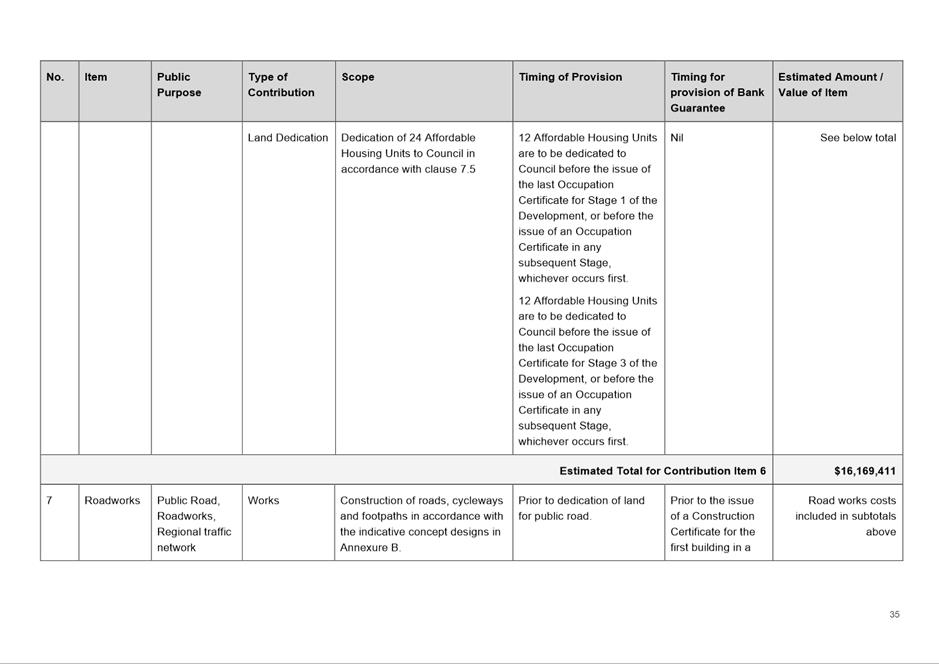
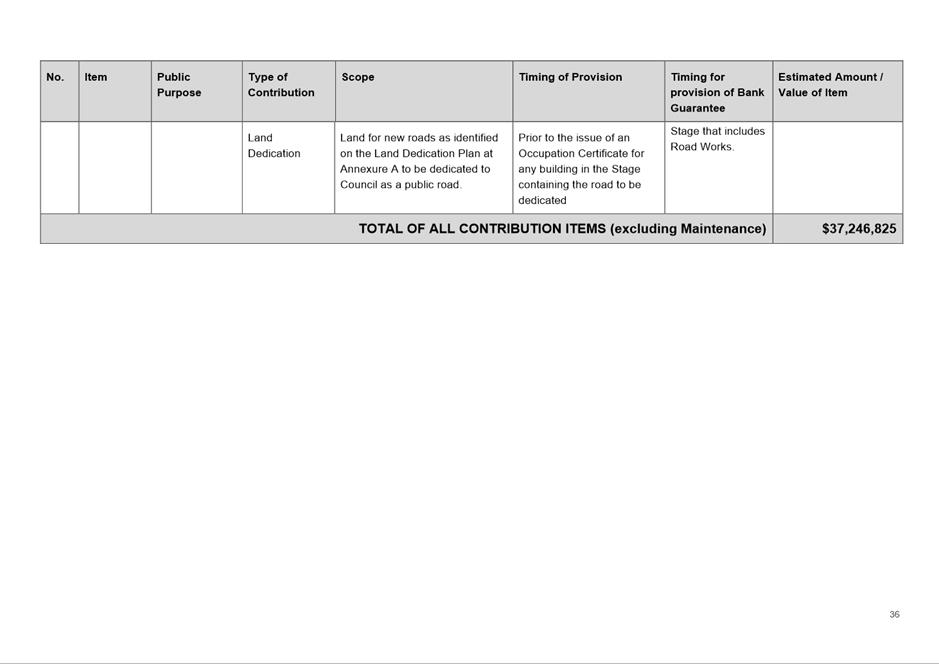
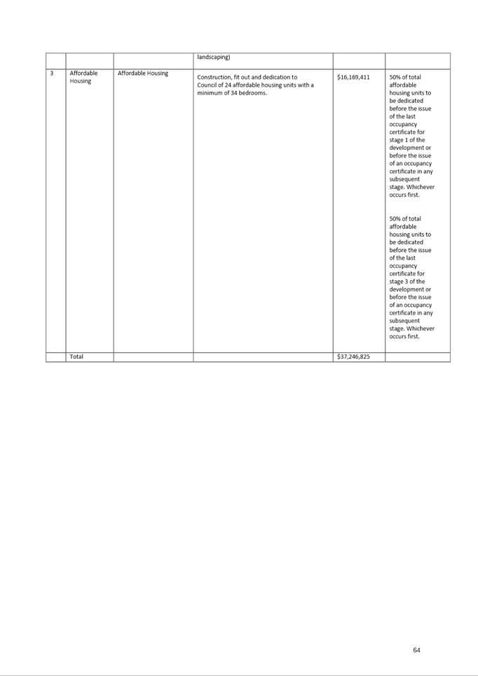
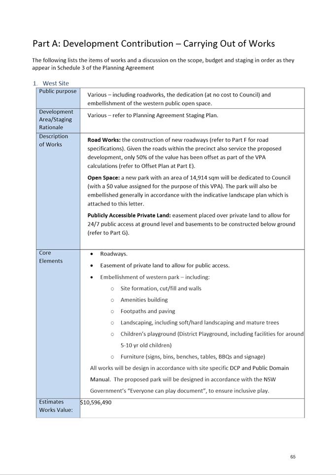
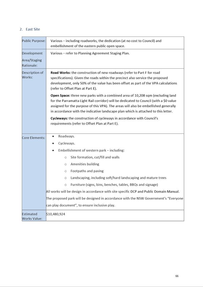
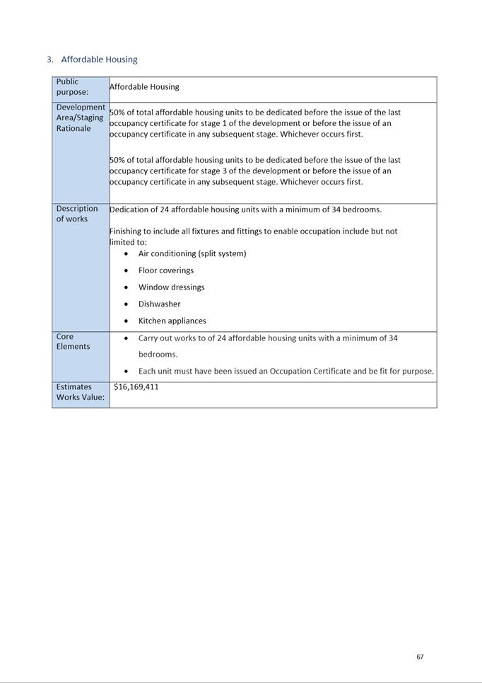
of $37,246,825 and proposed to deliver the following items.
|
NO
|
ITEM
|
CONTRIBUTION VALUE
|
|
1.
|
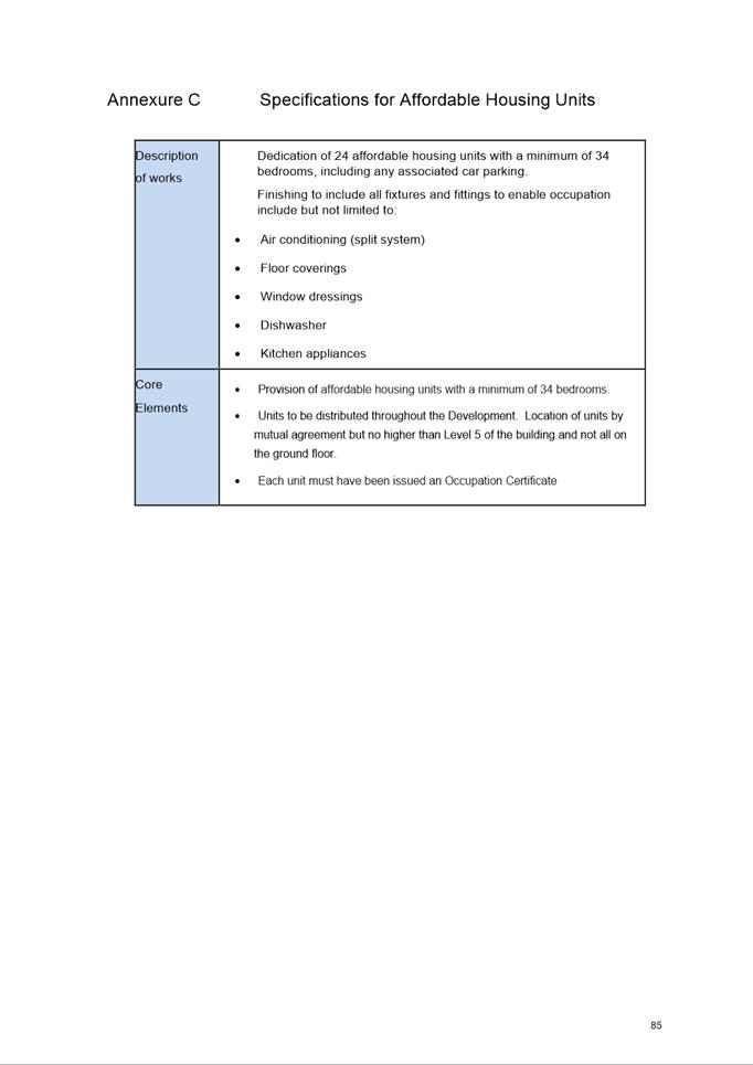
Affordable rental housing (24
units with a minimum of 34 bedrooms) dedicated to Council in perpetuity.
|
$16,169,411
|
|
2.
|
Dedication
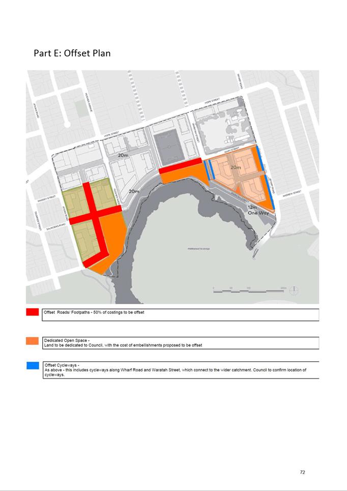
of land to be used as public open space to Council at no cost. Embellishment
of new public open space to Council’s requirements with a 50% offset*
included in the Planning Agreement for the cost of works.
|
$21,077,414
|
|
3.
|
Delivery
of cycleways and new roads with a 50% offset* for the cost of works included
in the Planning Agreement.
|
|
|
TOTAL VALUE OF OFFER
|
$37,246,825
|
|
Per Unit Contribution
|
$19, 349
|
* A 50% offset is included in the Planning
Agreement as an acknowledgement by Council that the subject works will benefit
the broader community and not just the residents within the development. It means
that half of the identified cost of delivering this infrastructure is offset by
Council and half is offset by the developer.
33. This
offer is the result of extensive negotiations over the past 12 months and is
considered an appropriate contribution towards the provision of local
infrastructure. The items included in the offer are consistent with the
Infrastructure Needs List (INL) for the precinct which is to be used to inform
all Planning Agreements in the precinct.
34. Comments on the draft Planning Agreement that were raised
in submissions related to appropriateness of the included infrastructure items.
Council officer responses are provided later in this report.
CONSULTATION
35. The Planning Proposal,
draft Site-Specific DCP and Draft Planning Agreement and supporting documents
were publicly exhibited from 25 August to 21 September 2022. During this time
the community was invited to comment on the draft documents. Notification
methods used in the exhibition included:
a. Letters to landowners
within a 1km radius of the site, including those within the Ryde LGA (over
6,400 letters in total);
b. Dedicated exhibition
page on Council’s Participate Parramatta website;
c. Advertisement on
Council’s website;
d. Hard copies of the
draft documents and supporting information provided at Council’s Customer
Contact Centre, Parramatta Library and Ermington Branch Library;
e. Geo-targeted social
media campaigns on Council’s Facebook and Instagram platforms; and
f. Advertisement in Parra News.
36. Public
agencies and State Members of Parliament were also notified in writing of the
public exhibition, with the following consulted:
|
·
Transport for NSW
|
·
City of Ryde Council
|
|
·
Transport for NSW -
Parramatta Light Rail
|
·
Sydney Water
|
|
·
Environment, Energy
and Science
|
·
Viva Energy
|
|
·
Department of
Education
|
·
Ausgrid
|
|
·
Heritage NSW
|
·
Transgrid
|
|
·
Fire and Rescue NSW
|
·
Endeavour Energy
|
|
·
Western Sydney Local
Health District
|
·
Dr Geoff Lee MP,
Member for Parramatta
|
|
·
NSW Ministry of
Health
|
·
Victor Dominello MP,
Member for Ryde
|
|
·
Greater Cities
Commission
|
|
37. A total
of eighty-six (86) submissions were received from 85 submitters (two
submissions were received from the same submitter) as part of the community
consultation period. A detailed breakdown of positions taken by the submitters
is provided in Table 3. Overall, 3% of submissions supported the Proposal in full
and 77% objected to the Proposal in full. Other submissions either partially
supported or objected or were uncertain.
A breakdown of who made submissions is provided in Table 4.
Table 3. Breakdown of submission positions
|
POSITION
|
TOTAL NUMBER
|
PERCENTAGE %
|
|
Support
|
2
|
3
|
|
Object
|
65
|
77
|
|
Partial Objection
|
1
|
1
|
|
Partial Support
|
7
|
8
|
|
No Objection
|
4
|
4
|
|
Neutral
|
6
|
7
|
|
Total
|
85
|
100
|
Table 4. Breakdown of submissions received
|
|
NUMBER
|
BREAKDOWN
|
|
Community/landowners
|
77
|
Various residents,
landowners and stakeholders
|
|
Public Agencies
|
4
|
·
Western
Sydney Local Health District
·
Environment,
Energy and Science Group (part of DPE)
·
Transport
for NSW (combined with PLR)
·
Education NSW/School
Infrastructure NSW
|
|
Other Organisation
|
4
|
·
Endeavour
Energy
·
City of
Ryde Council
·
Community
Housing Industry Association NSW
·
Mecone
|
|
Total
|
85
|
|
COUNCIL OFFICER
RESPONSES TO KEY ISSUES RAISED IN SUBMISSIONS
38. A summary of the common
concerns raised in the submissions and Council officer responses is provided
below. A number of other concerns were raised in submissions in addition to
those mentioned below. Detailed Council officer responses are provided in Attachment 2 to this report. While a number of issues have been raised
in relation to the exhibited planning provisions, it is considered that these
matters are addressed in the draft provisions or can be addressed as part of
the detailed design at the development application stage. Therefore, no changes
to the exhibited draft Planning Proposal, DCP or Planning Agreement are
recommended as a result of the issues raised in submissions.
39. The most common themes
raised by community members/landowners were as follows:
a. building height, scale, location, and local
character/amenity (raised by 78%),
b. Traffic impacts, parking, and Transport Management and
Accessibility Plan (TMAP) (raised by 70%),
c. Infrastructure provision (raised by 70%),
d. Environmental impacts (raised by 34%),
e. Heritage impacts (raised by 9%), and
f. Consultation process (raised by 9%).
Building Heights and
Amenity
40. Most submissions objecting
to the exhibited scheme raised concerns regarding the proposed building
heights, advising they are too high resulting in overshadowing, loss of privacy
and neighbourhood character, in addition to being inconsistent with the Southern
Structure Plan that was adopted by Council on 16 December 2019.
Council Officer Response
41. It is acknowledged that there are some differences between
the proposed building heights identified in the Southern Structure Plan,
however they are considered to
remain consistent with the envisaged approach for the precinct. The proposed height variation on the East Site
ranges between an additional 7m to 10m above those identified within the
Southern Structure Plan. On the West Site, the height variation ranges between
an additional 10m and 19m above that identified in the Southern Structure Plan.
42. The proposed buildings
heights identified on the subject sites in the Proposal have been informed by
those identified in the Southern Structure Plan, which was a high-level guiding
document intended to inform any future Planning Proposal in the Precinct.
Although urban design testing was undertaken as part of the development of the
Southern Structure Plan to determine appropriate height and FSR controls, it was
acknowledged that these would be subject to further, detailed testing and
refinement at the Planning Proposal stage.
43. As a result of detailed
testing and discussions between Council officers and the proponent as part of
the Planning Proposal and DCP work, some variations to building height were
considered appropriate to produce a better built form outcome. These height
variations do not result in an increase in the gross floor area (GFA)
identified on these sites in the Southern Structure Plan. Additionally, the
core principles of the Southern Structure Plan have been retained, which
include:
a. ensuring that the taller buildings are located within the
centre of the site and away from existing low-density residential development
surrounding the precinct;
b. ensuring that each building has a courtyard width greater
than that is required by the Apartment Design Guide;
c. that solar access within and outside of the two
development sites is maximised;
d. maintaining key view lines outside the precinct to minimise
the perception of density; and
e. maintenance of the 17m landscaped buffer along Wharf Road.
44. While the variations may
not appear to be minor, they have enabled better utilisation of lower building
heights on the perimeter of the site and improve the interface to surrounding
lower density areas. The draft DCP (refer to Appendix 3)
shows buildings of four (4) storeys can be achieved in certain areas on the
West Site because of the heights increasing elsewhere. Council officers
consider that lower perimeter heights are preferred even if it results in the
taller building in the centre of the site. These amended heights have been
tested and comply with solar access and other Apartment Design Guide (ADG)
requirements.
45. In addition, the draft DCP
includes objectives and controls relating to built form, which specifies
requirements such as building setbacks, building separation, the distribution
and allocation of floor space on a block-by-block basis, and tower design and
slenderness. These controls are intended to ensure that the perception of the
building heights within the precinct is minimised at street level.
46. The issues raised in
relation to the height of buildings are therefore not considered sufficient
justification to warrant a reduction in the proposed building heights on the
site. Extensive urban design testing has been undertaken to demonstrate that the
proposed heights can be achieved without significant and unmanageable impacts
being experienced by future or surrounding residents and this is considered to
be consistent with the core principles of the adopted Southern Structure Plan.
It is therefore recommended that the provisions be retained as exhibited.
Traffic Impacts and
Transport Management and Accessibility Plan (TMAP)
47. Most submissions objecting
to the proposal raised concern regarding the potential traffic impacts on the
existing road network, particularly within the Ryde LGA, and questioned the
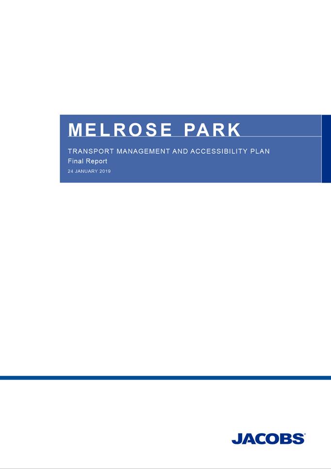
TMAP’s (Attachment 7)
validity, relevancy to current
road and traffic conditions, and level of consultation with Ryde Council.
Council Officer Response
48. It is acknowledged that
any redevelopment within the Melrose Park precinct will have some impact upon
the local road network and to a lesser extent, the wider regional network.
49. A TMAP was prepared in
response to a Gateway Determination condition relating to the Melrose Park
North Planning Proposal. The aims of the TMAP were to understand the existing
traffic behaviour, road network capacity and public transport services and
identify improvements to public transport and the road infrastructure that would
be required to support the proposed redevelopment of the Melrose Park precinct
at each stage of its redevelopment. The TMAP was subject to extensive review
and consultation by the TMAP reference group, which comprised stakeholders from
Council and State Agencies, including Transport for NSW (TfNSW), DPE, and
applicants from the northern and southern precincts of Melrose Park. The TMAP
was signed off and endorsed for exhibition by TfNSW.
50. The TMAP is required to be
utilised for all Planning Proposals within Melrose Park in addition to
site-specific traffic studies for each Planning Proposal. While not involved in
the TMAP reference group, Ryde Council officers were briefed in the TMAP, and
their input was provided as part of the exhibited Planning Proposal for the
Melrose Park North Precinct. Should a review of the TMAP be required, further
input from Ryde Council will be sought to ensure any additional concerns have
been addressed.
51. The TMAP is an informing
document to the Proposal and provides a comprehensive analysis of the potential
traffic and parking impacts and includes required mitigation measures that
future redevelopment must deliver to ensure the traffic and transport network
can accommodate the proposed increase in density on the site. It also provides
a Staging Plan for the delivery of required road upgrades and public transport
infrastructure to service the precinct as well as recommended parking rates.
Refer to Table 4 for a summary of the staging plan and dwelling
thresholds. As development progresses, the applicant will need to demonstrate
that the required infrastructure will also be delivered as identified in the
TMAP’s staging plan.
Table 4. TMAP infrastructure staging plan
|
STAGE
|
INFRASTRUCTURE TRIGGER POINT (DWELLINGS)
|
YIELD SUPPORTED (DWELLINGS)
|
KEY INFRASTRUCTURE REQUIRED
|
|
Existing network
|
NA
|
1,100
|
Nil
|
|
Stage 1A
|
1,100
|
1,800
|
Wharf Road widening
south of Victoria Road
Left in/left out
access from Victoria Road to NSR2
|
|
Stage 1B
|
1,800
|
3,200
|
Upgrades of Victoria Road/Wharf
Road intersection including additional turning lanes
Additional
through-lane on Marsden Road
|
|
Stage 1C
|
3,200
|
6,700
|
Further upgrades of
Victoria Road/Wharf Road intersection
- Full
signalisation
- Additional
R turn lanes on Victoria Rd
- 3 new
lanes on southern Kissing Point Road approach
- 4 new
lanes on northern approach Kissing Point Road approach
- New
signalised pedestrian crossings
- Widening of Victoria Rd between Kissing Point
Road and Wharf Road
- - Shuttle bus service to Meadowbank Station
and increased frequency of public services throughout Stage 1
|
|
Stage 2
|
6,700
|
11,000
|
New bridge to
Wentworth Point and PLR Stage 2 or bus equivalent
Staged delivery of
internal road network
Increased public
transport services
|
52. Stages 1A, 1B and elements
of Stage 1C are being delivered as part of the redevelopment in the northern
part of the precinct, which will enable the 6,700 dwelling capacity to be
realised. In addition, the State Government has committed to providing the bridge
to Wentworth Point to be utilised by public and active transport users.
Although the bridge may not be delivered for several years and may not
immediately accommodate light rail services, it is expected that the timing of
construction being finished will coincide with the earlier stages of
redevelopment of the precinct also being completed. The bridge to Wentworth
Point is a significant undertaking and will allow residents on the North side
of Parramatta River to access the Sydney Metro West Station at Sydney Olympic
Park. This will provide considerable public transport benefits to future
residents in Melrose Park and as well as those within the Ryde LGA.
53. The methodology and the
assumptions and inputs used in the TMAP were presented to and endorsed by the
project reference group in the early stages of the project and were considered
appropriate to ensure the results would be an accurate reflection of the
potential changes to the use and density of the Precinct. The outcomes of the
TMAP testing were also supported by the project reference group prior to
finalisation of the TMAP report.
54. Despite the TMAP being
finalised in early 2019, it retains its relevancy and ability to provide
direction for the precinct. Technical studies relating to large projects such
as Melrose Park North are prepared at varying stages throughout the
project’s life and, it is not uncommon for the studies to precede the
project’s exhibition date given that they are used to inform the content
that is ultimately placed on exhibition. In this instance, any change in inputs
used for the modelling and assumptions is likely to not be significant and
would have a negligible impact in the TMAP’s results, particularly as the
overall dwelling yields that have been modelled are not subject to change.
55. In response to concerns
raised regarding local traffic impacts, especially on Andrew Street and
Constitution Road West within the Ryde LGA, these areas were included in the
TMAP’s study area and therefore considered during the modelling phase.
The TMAP does not identify a need for any specific upgrades or alterations to
these roads as part of future works. However, traffic management solutions
implemented on the roads within the southern precinct such as turning
restrictions from the precinct into Andrew Street to discourage rat-running by
drivers trying to avoid Victoria and Wharf Roads will be explored in further
detail at the development application stage. Traffic management measures can
also be reviewed at any time regardless of whether they are associated with
proposed redevelopment. Council’s Traffic team will continue to monitor
the functionality of the road network within the precinct as development
progresses and after full redevelopment of the precinct has occurred to
determine what measures will be required to address any traffic management
concerns.
56. No change is recommended
to the TMAP at this stage. The TMAP is still considered to be a relevant
document for its intended purposes given the overall dwelling yields that have
been modelled in the Precinct have not changed since the study delivered its
initial recommendations. The infrastructure upgrades required to meet the
density thresholds, many of which are to be delivered as part of redevelopment
in the northern precinct, are considered to be sufficient to reasonably
accommodate the proposed development. Solutions to manage potential commuter
traffic behaviour into Andrew Street are not identified in the TMAP or the
proponent’s Traffic Assessment, however, will be explored in further detail
at the development application stage.
Infrastructure
Provision
57. Many submissions commented
that the Planning Proposal and draft Planning Agreement do not provide
sufficient infrastructure within the precinct nor propose any contribution
towards funding new infrastructure or upgrades to existing infrastructure
within the Ryde LGA.
Council Officer Response
58. The Melrose Park precinct
is intended to be self-sufficient in providing for the daily recreation needs
and in the provision of local retail/commercial facilities for incoming
residents. Therefore, it is not considered that the majority of residents will
regularly leave the precinct for these reasons. It is acknowledged however that
the incoming residents to Melrose Park will potentially utilise some
infrastructure such as roads and public open space located within the Ryde LGA.
However, this is not expected to place a significant burden on this
infrastructure. In return, residents within the Ryde LGA will likely utilise
the new infrastructure within Melrose Park, such as new open space along the
foreshore, the new playing field in the northern precinct, new retail services
in the town centre and George Kendall Riverside Park. George Kendall Riverside
Park provides for regional organised sporting facilities in additional to
informal active recreation, which is similar in function to Meadowbank Park
within the Ryde LGA. Incoming residents are expected to more readily utilise
the facilities of George Kendall Riverside Park, which provides similar
amenities to Meadowbank Park, due to its closer proximity
59. With regards to increased
road usage outside the precinct within the Ryde LGA, traffic modelling
undertaken for this precinct as part of the TMAP indicates that a significant
increase in the volume of traffic is not anticipated as a result of the
redevelopment of the precinct. Extensive upgrades are proposed to Wharf Road
and Victoria Road to increase efficiency at this intersection, and it is
possible to incorporate traffic management measures as part of future
development applications to discourage commuter vehicles from using Andrew
Street during peak times. It is not anticipated that the additional traffic on
local roads within the Ryde LGA will significantly accelerate road
deterioration.
60. Further, the introduction
of light rail or alternative public transport service to the precinct will
enable residents to connect to the new Sydney West Metro service at Sydney
Olympic Park, resulting in fewer vehicles relying on the road network.
Character Loss
61. A high proportion of
submissions raised concern regarding a loss of neighbourhood character that
will result from the proposed redevelopment.
Council Officer Response
62. It is acknowledged that
Melrose Park has an established character both as industrial within the
Parramatta LGA and low density residential within the Ryde LGA. The proposed
changes to the precinct within Parramatta are necessary because of the
declining functionality of the existing industrial land, as evidenced in the
Planning Proposal and within the 2016 Council Employment Lands Strategy, which
was also confirmed in the 2020 revision. Further, Melrose Park is identified as
a Local Centre within the LSPS and is therefore suitable for high density
residential development as an identified Growth Precinct.
63. Whilst the introduction of
high-density residential development will change the existing character, it is
intended to revitalise the area and create a vibrant urban environment with
improved amenities for residents within and adjacent to the precinct. This will
occur through the introduction of new public open space, a new primary school
(in the northern precinct), and 30,000m2 of new retail and
commercial facilities as part of the new town centre in the northern precinct.
The precinct has been designed to minimise impacts on adjoining low density
residential properties through the use of landscaped buffer zones along Wharf
Road and lower building heights on the perimeter of the development.
SOUTHERN PRECINCT LANDOWNER SUBMISSIONS
Southern Precinct Landowner Group
(Mecone)
64. A
submission was received from a representative of multiple landowners within the
southern precinct. The submission does not object to the redevelopment of the precinct
but does comment on the proposed non-residential floor space provision,
considering it to be insufficient, and raises concern regarding the proposed
building height variation from the Southern Structure Plan and considers that a
finer-grained approach should be applied in the LEP mapping.
Council Officer Response
65. The
matters raised in this submission are noted. It is considered that they can be
addressed through further discussion with the relevant landowners to determine
potential future intentions for the respective sites to achieve the best
possible outcome. A portion of the required non-residential floor space is
being provided within the northern precinct as part of the new 30,000m2
town centre, which will serve many of the community’s needs. With regards
to the difference in building height per the Southern Structure Plan this is
addressed under ‘Building Heights and Amenity’ above.
George Weston Foods
66. A
submission was received from the landowner of a site currently occupied by
large scale bread manufacturing operations. The submission raised no objection
to the draft Planning Proposal, however raised concerns regarding the potential
for land use conflicts between existing industrial uses and future high density
residential uses, loss of employment, and the distribution of building height
and FSR allocations.
Council Officer Response
67. It
is acknowledged that the presence of contrasting land uses while the precinct
undergoes redevelopment is a matter that will need to be carefully managed,
however it is considered that the DCP and other applicable controls will ensure
that any potential negative amenity impacts, and interface issues are minimised
as the precinct transitions away from industrial uses. The loss of industrial
employment will be largely offset by the introduction of retail and commercial
employment principally within the town centre. Again, issues relating to
building heights are addressed under ‘Building Heights and Amenity’
above.
AGENCY SUBMISSIONS
68. A total of seventeen (17)
public and private agencies and organisations were notified as part of the
public exhibition, with seven (7) submissions received. These submissions are
briefly summarised and addressed below..
Transport for NSW (TfNSW) / Parramatta Light Rail (PLR)
69. The combined submission
from TfNSW and PLR raises no objection to the Planning Proposal, but provides
several comments as follows:
a. The need for proponents
in Melrose Park South to contribute to the infrastructure and services.
b. Suggestion that any amendment to PLEP 2011 for the southern precinct
include similar provisions for the concurrence of the Planning Secretary as the
northern precinct and that the proponent should enter into a Planning Agreement
outlining the developer’s contribution to delivering State infrastructure
and services.
c. That the State Government has committed funding of some nearby major
public transport initiatives including Sydney Metro West and a public and
active transport connection across Parramatta River to accommodate the future
Parramatta Light Rail Stage 2 and public bus operations.
d. That the timing of delivery of this State infrastructure may be
after redevelopment of the precinct and it’s therefore important that the
early stages of development need to be supported by shuttle buses to nearby
transport hubs provided by proponents.
e. It is estimated that a 50% share of trips will be made by active and
public transport by future residents of Melrose Park. It is therefore important
that road reserves (carriageway and footways) can appropriately and safely
accommodate public transport, freight, and active transport.
f. That it is unclear whether the needs of the local road users have
been fully considered, particularly in the areas adjacent to the proposed town
centre.
g. That it is unclear from the plans included in the DCP whether
adequate space has been allocated along Hope Street to cater for future public
transport services and active transport movements.
h. That a provision relating to the operating length of any shuttle bus
be inserted into the draft Planning Agreement.
i. That land proposed for dedication along the PLR corridor be made
clear in the Planning Agreement.
Council Officer
Response
70. These
matters are noted, and it is considered that they can be addressed as part of
the post exhibition and finalisation processes of the Planning Proposal, DCP
and Planning Agreement.
71. With
regards to the recommendation for a provision for a shuttle bus to be inserted
into the Planning Agreement, it is noted that a shuttle bus is proposed to
serve all of Melrose Park as part of the draft Planning Agreement associated
with the Melrose Park North Planning Proposal. It is insufficient for each
developer to run their own respective shuttle bus service in this regard. The
shuttle bus is expected to run until such time that Parramatta Light Rail
(stage 2) or similar is provided in conjunction with the bridge (now committed
to by the State government) connecting the precinct to Wentworth Point.
Department of
Education / School Infrastructure NSW
72. The submission from School Infrastructure NSW
raised no objection to the Proposal but does comment on several matters for
consideration. These relate to the demand for educational facilities within the
precinct, overshadowing and privacy impacts on the existing Melrose Park Public
School, active transport and access and infrastructure contributions. The
submission provided no clear direction on the provision of a secondary school
within the precinct or within the catchment of the precinct.
Council Officer Response
73. The matters raised in the submission are
noted. It is considered that potential overshadowing and privacy impacts on the
existing school site as a result of the proposed redevelopment can be addressed
in detail at the development application stage, as can active transport and
access needs.
74. The matter of demand for educational
facilities, in particular the provision of a secondary school facility, is an
ongoing concern for Council officers which requires an active and considered
approach from School Infrastructure NSW as a priority to ensure that the
education needs of the precinct can be met. School Infrastructure NSW has
stated in its submission its commitment to ensuring public schools are
supporting the community’s needs and continue to be appropriately
resourced to respond to student population changes. A provision for ensuring
this matter is appropriately addressed by School Infrastructure NSW is proposed
to be included in PLEP 2011 through the use of a concurrence clause that will
require the Planning Secretary to be satisfied that State public infrastructure
needs (including transport and schools) are met before development proceeds. With
regards to the request for public schools to be exempt from paying development
contributions, this matter will be considered by Council officers as part of
ongoing reviews of Council’s infrastructure contributions plans.
Western Sydney Local
Health District
75. The submission from the Western Sydney Local
Health District raised no objection to the Proposal but recommends that several
matters be considered by Council officers relating to mosquito management in
the foreshore area along the southern boundary of the precinct, potential
outdoor recreation space use, and river front access after storm events.
Council Officer Response
76. The matters raised in this
submission are noted. Council has an Intertidal Management Plan to
manage mosquitos in urban areas and it is considered that riverfront access can
be managed through existing procedures.
Environment,
Energy and Science
77. The submission from
Environment, Energy and Science (EES) raised no objection to the Proposal.
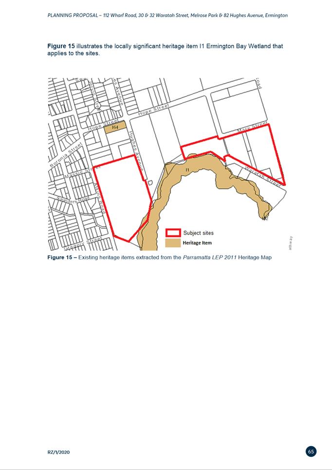
Comment is made on the biodiversity value of the Ermington Bay Wetland and
identified potential impacts from shadowing and sedimentation. Comment is also
made on flooding considerations and recommendations for further flood studies
to be undertaken.
Council
Officer Response
78. The ecological
significance of the Ermington Bay Wetland is known by Council and protection of
this sensitive ecosystem is an essential element for the future development of
the Melrose Park Precinct. It is considered that the potential overshadowing impacts
and sediment control can be managed by careful design and layout of the
buildings and though soil management strategies. These matters, including
detailed flood modelling, will be further addressed at the development
applications stage.
City of Ryde
Council
79. The
submission objects to the Planning Proposal and raises some concern regarding
the proposed additional permitted use on the site of ‘food and drink
premises’’. Comment is also made on the draft local Planning
Agreement relating to the lack of contributions towards funding infrastructure
upgrades within the Ryde LGA and concern around the proposed securities for
some items. Comment is also made on the application of Council’s
contributions plans and on the lack of proposed open space provision and road
and traffic network impacts, considering them to be unacceptable.
Council Officer Response
80. The
proposed zoning and the suite of potential uses that might be proposed are
considered reasonable to ensure a vibrant precinct is delivered. Any impacts
from other specific potential land uses that may become permissible as a result
of the rezoning will be subject to a detailed assessment as part of a
development application should such a use be proposed. This assessment process
will include a further public exhibition period where input from the community
will be sought. If proposed, any ‘food and drink premises’ must
demonstrate that the potential amenity impacts from its operation are
considered acceptable in order for it to be approved.
81. The
draft Planning Agreement is between the City of Parramatta Council and the
proponent. As indicated above, it is not considered that the anticipated
population of Melrose Park will result in significant increases in demand on
infrastructure within the Ryde LGA particularly given the recreational and
active open space areas that will be provided within the Melrose Park Precinct,
which will also be available for use by residents within the Ryde LGA to use if
they wish. Therefore, no contributions are proposed to fund specific works
within the Ryde LGA. The infrastructure to be delivered as part of this
development and the broader redevelopment of the precinct has been identified
in the INL and the requirements for each Planning Proposal are assessed using
this list and on a merit basis to determine whether it is appropriate for
additional infrastructure to be included in Planning Agreements.
82. Any
proposed traffic management works required to be undertaken to reduce the
impact on traffic flow within the Ryde LGA as a result of the proposed
development can be addressed at the development application stage. Council
officers will hold discussions with Ryde Council staff regarding appropriate
solutions and traffic treatments to ameliorate any problems that should arise
as the precinct redevelops.
83. In
relation to the non-inclusion of clauses in the Planning Agreement regarding
securities and defects periods, this was an unintentional omission and will be
addressed prior to the Planning Agreement being executed. The proponent has
agreed to the inclusion of such provisions. These provisions do not impact on
the value of the items proposed to be delivered in the Planning Agreement.
Endeavour Energy
84. The submission received from Endeavour Energy
raised no objection to the Proposal. The submission comments on the current
capacity of the network and suggests that a new zone substation may be required
within the precinct to ensure future demand can be met.
Council Officer Response
85. The
comments raised in this submission are noted. Any future upgrades required to
the network as part of the redevelopment will be addressed at the development
application stage.
Community Housing Industry Association
NSW
86. This
submission supports the proposed inclusion of affordable rental housing units,
however, does question why more units are not being provided given the proposed
uplift. Comments are made on affordable rental housing strategies for Council’s
consideration to ensure adequate provision in future redevelopments.
Council Officer Response
87. The comments made in this submission are noted
and the exploration of alternative options for securing the provision of
affordable rental housing will always be pursued. The approach taken when
negotiating the affordable rental housing provision as part of this Planning
Proposal and Planning Agreement was that preference was given to securing
affordable rental units in perpetuity in addition to securing other required
infrastructure in the precinct. This is considered better than relying on the
provision of affordable rental housing via the State Environmental Planning
Policy (Housing) 2021 (Housing SEPP) which only guarantees the provision of
said housing for a limited time period. The draft Planning Agreement does not
preclude the provision of affordable rental housing under the Housing SEPP at
the development application stage.
FINANCIAL IMPLICATIONS FOR COUNCIL
88. Any
work to progress the finalisation of the Planning Proposal would be prepared by
Council Officers and therefore within the existing City Planning and Design
budget. Should this matter
progress, a Planning Agreement delivering new public open space, social and
community infrastructure to the value of $37,246,825 will be entered into
between Council and the applicant. Further, at development application stage,
development contributions in keeping with the current rates contained in the
former Parramatta Section 94A Development Contributions Plan (Amendment No. 5)
2017 will be applied to the development.
CONCLUSION AND NEXT
STEPS
89. It is recommended
that the Local Planning Panel support the Council Officer recommendation that
the Planning Proposal be referred to the DPE for finalisation.
90. Council
officers recommend that the Local Planning Panel support the Council Officer
recommendation to finalise the draft DCP, which provides detailed design
controls in support of the Planning Proposal.
91. Council
officers recommend that the Local Planning Panel support the Council Officer
recommendation to adopt the draft Planning Agreement.
92. Following Local Planning Panel consideration of the recommendations of this
report, the outcomes of the exhibition period for the draft Planning Proposal,
Draft DCP and draft Planning Agreement will be reported to an upcoming Council meeting along with the Panel’s advice.
Amberley Moore
Senior Project Officer
Michael Rogers
Land Use Planning Manager
David Birds
Group Manager, Major Projects and
Precincts
Jennifer Concato
Executive Director City Planning and
Design
Attachments:
|
1⇩ 
|
Table of Community Submissions
|
28 Pages
|
|
|
2⇩
|
Responses to Issues Raised
|
20 Pages
|
|
|
3⇩
|
Updated Planning Proposal
|
81 Pages
|
|
|
4⇩
|
Site-Specific DCP (Melrose Park South)
|
102 Pages
|
|
|
5⇩
|
Southern Structure Plan
|
4 Pages
|
|
|
6⇩ 
|
Planning Agreement
|
90 Pages
|
|
|
7⇩
|
TMAP
|
117 Pages
|
|
REFERENCE MATERIAL