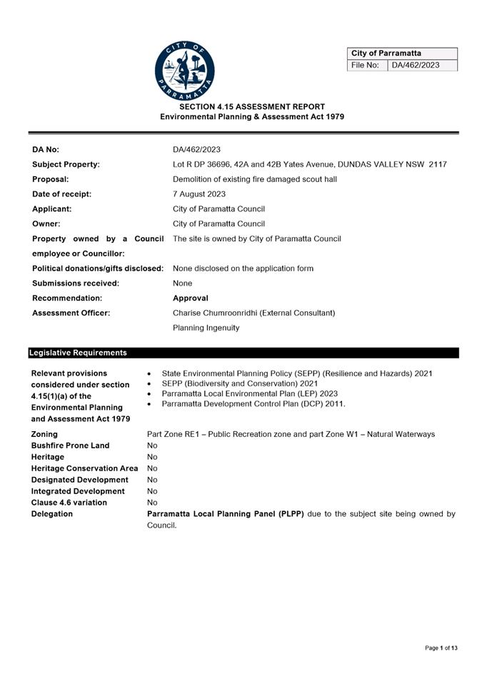
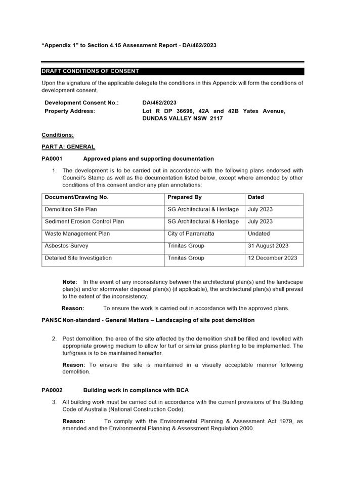
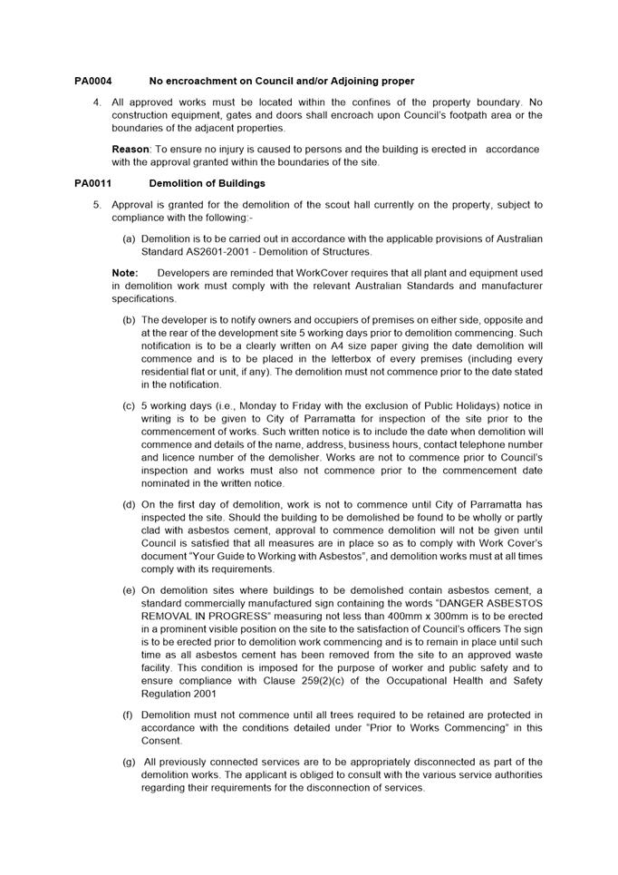
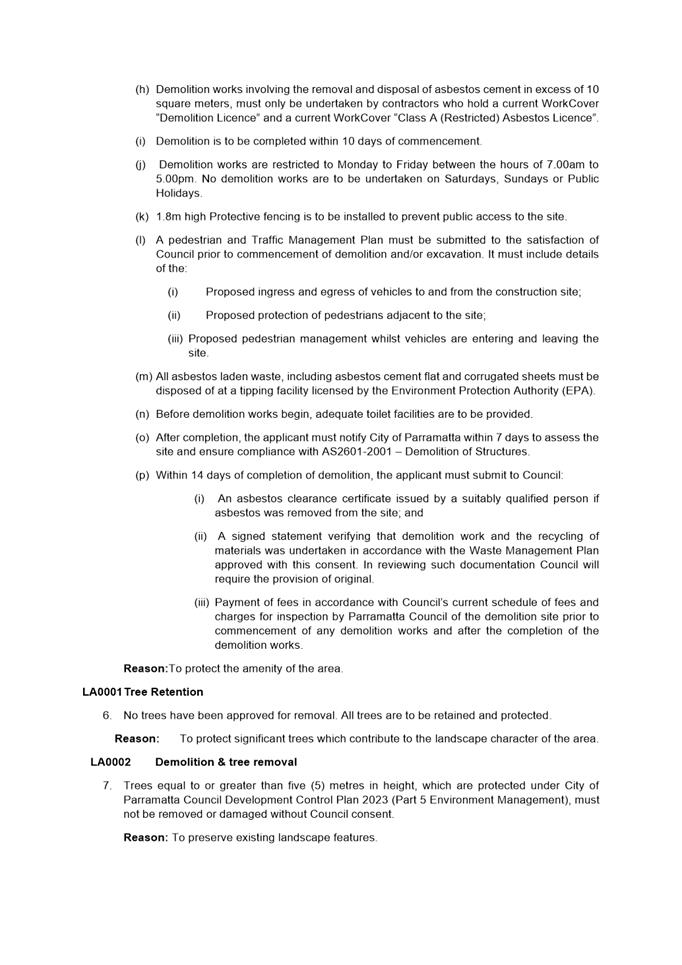
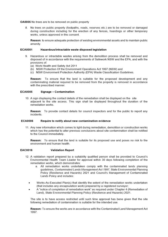
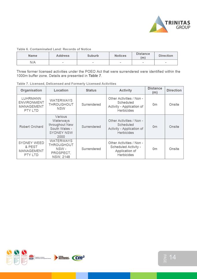
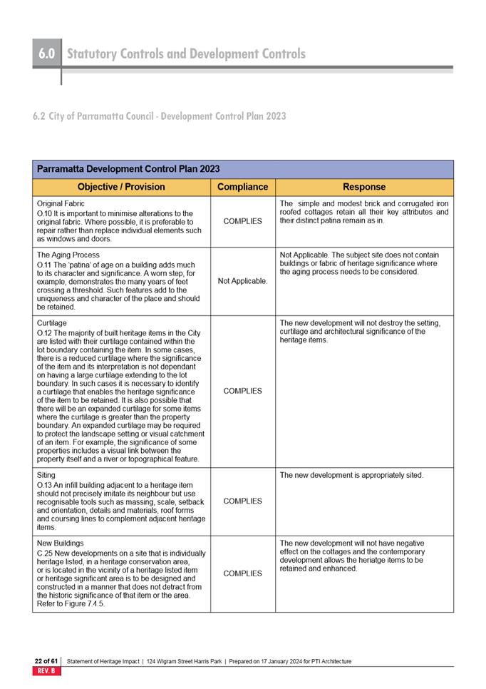
Local Planning Panel 20 February 2024 Item
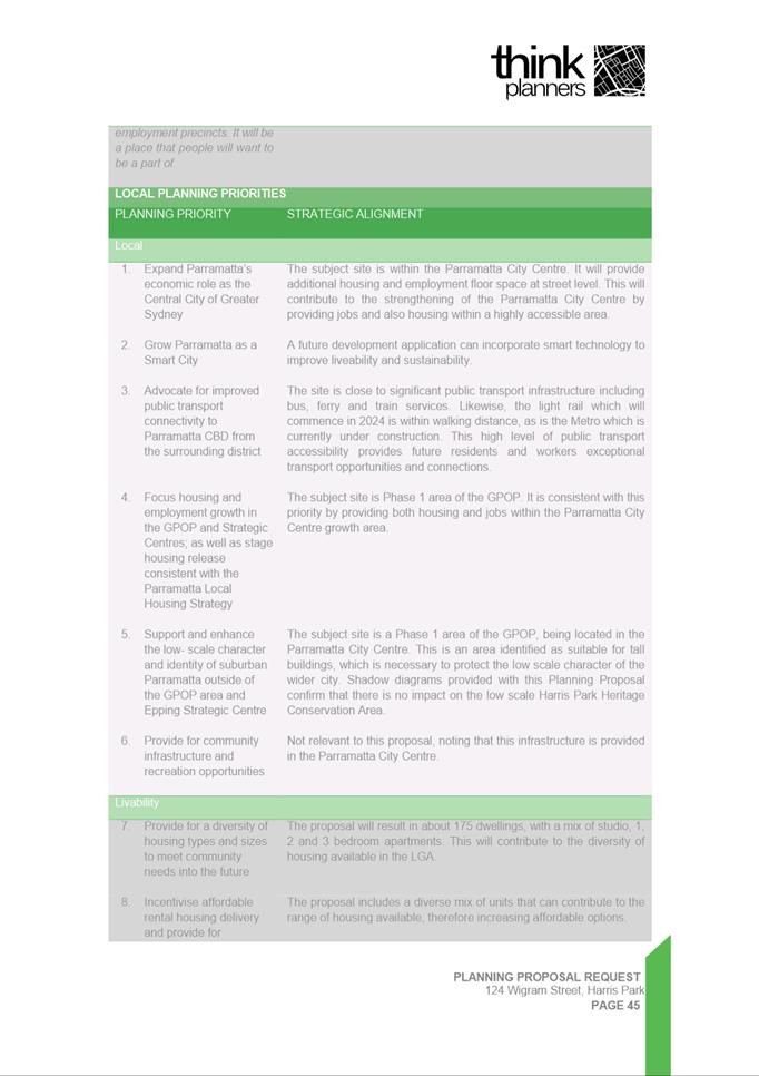
5.1
ITEM NUMBER 5.1
SUBJECT 54-56 Albert Street, NORTH PARRAMATTA NSW 2151 (Lot 200 DP 1104602)
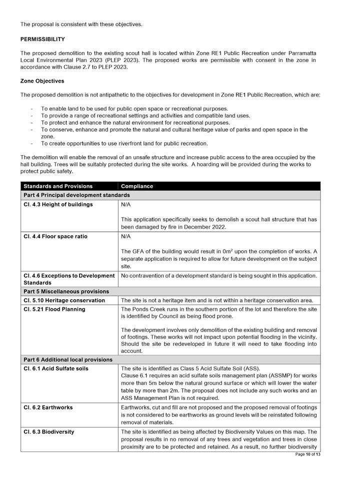
DESCRIPTION Strata Subdivision of Existing Residential Flat Building Complex.
REFERENCE DA/318/2023 - D09281792
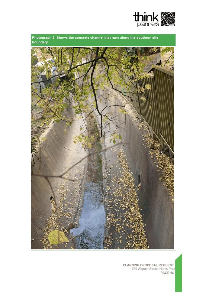
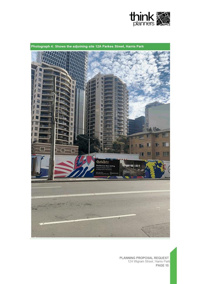
APPLICANT/S Richard Hogan and Co
OWNERS GS and MS Investments Pty Ltd
REPORT OF Group
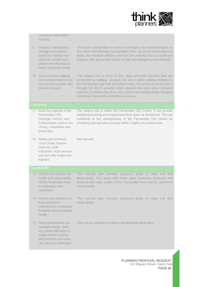
Manager Development and Traffic Services
RECOMMENDED Approval
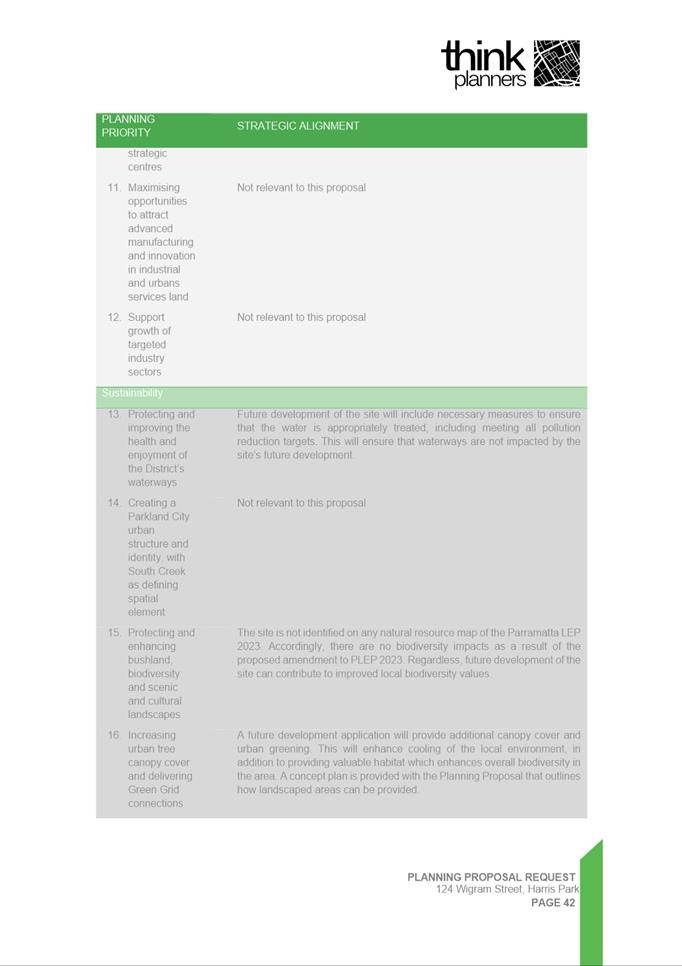
DATE OF REPORT 1 February 2024
REASON FOR REFERRAL TO LPP
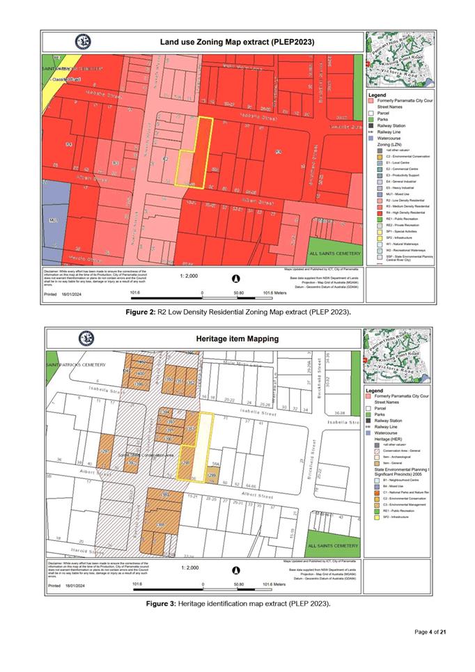
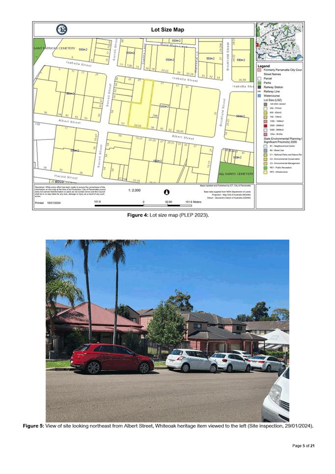
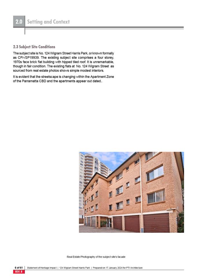
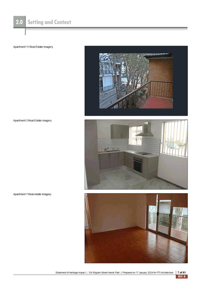
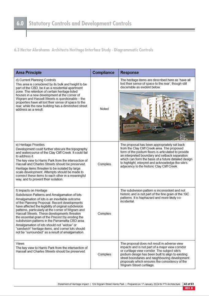
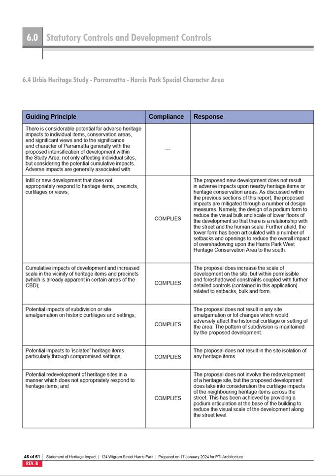
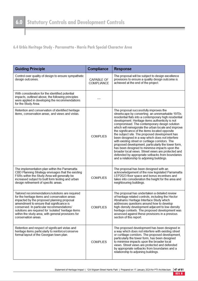
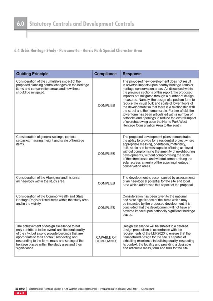
The proposed Strata Subdivision concerns existing buildings located
or partially located within land zoned R2 Low Density Residential. Therefore,
Clause 4.1A Minimum subdivision lot size for strata plan schemes in Zone R2
applies. In accordance with this clause a lot resulting from a subdivision of
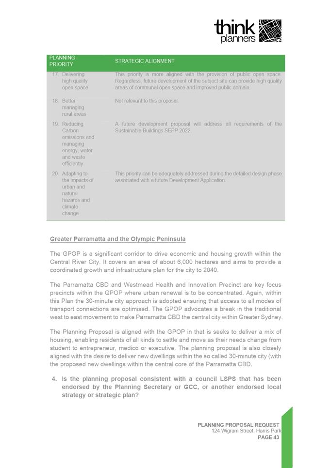
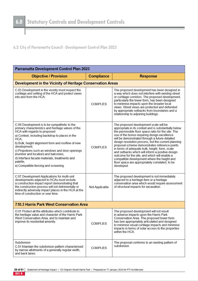
land by strata plan scheme must not be less than the minimum size shown on the
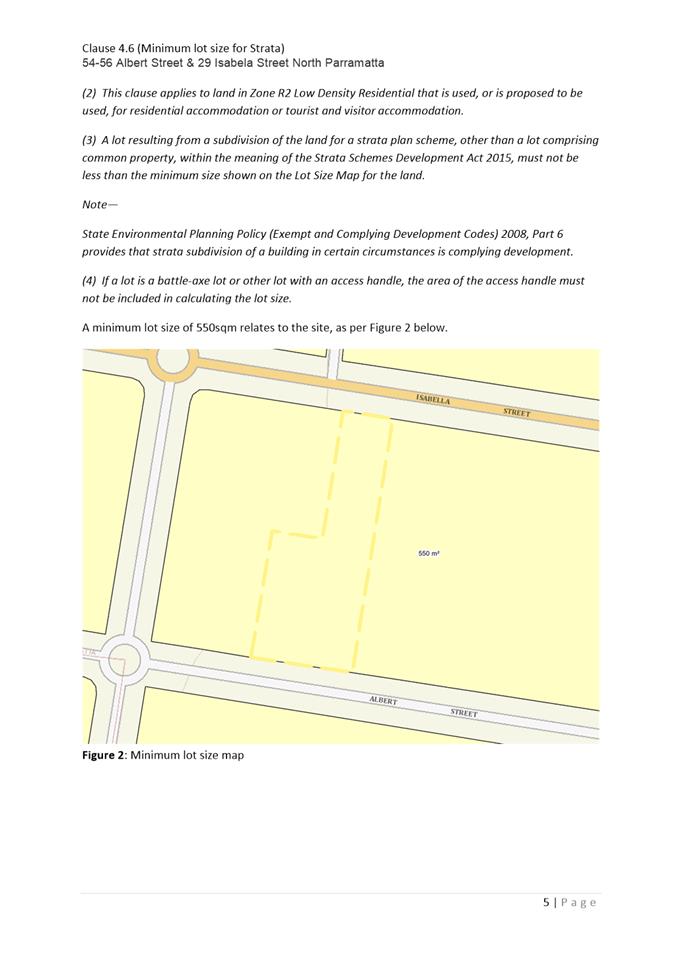
lot size map which in this case prescribes a minimum size of 550m2
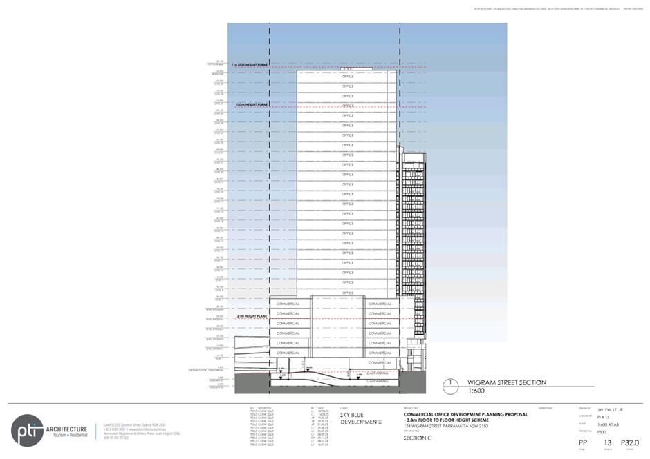
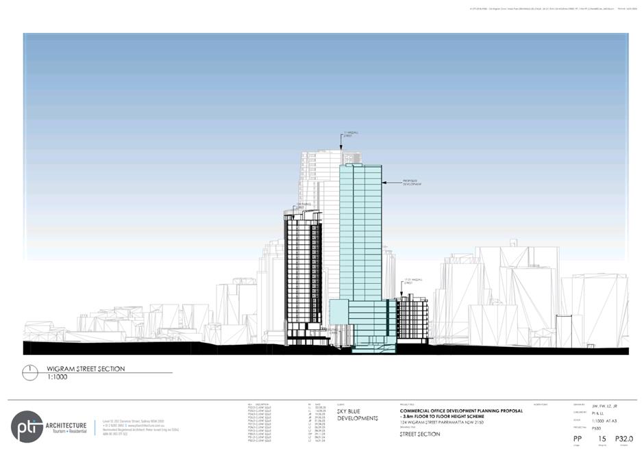
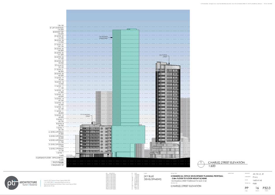
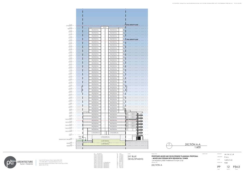
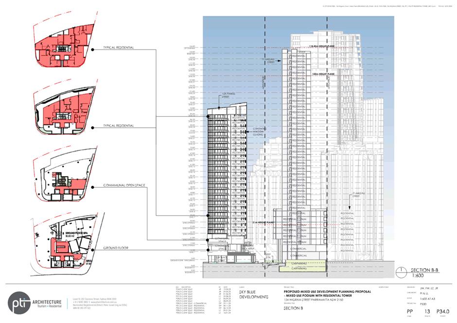
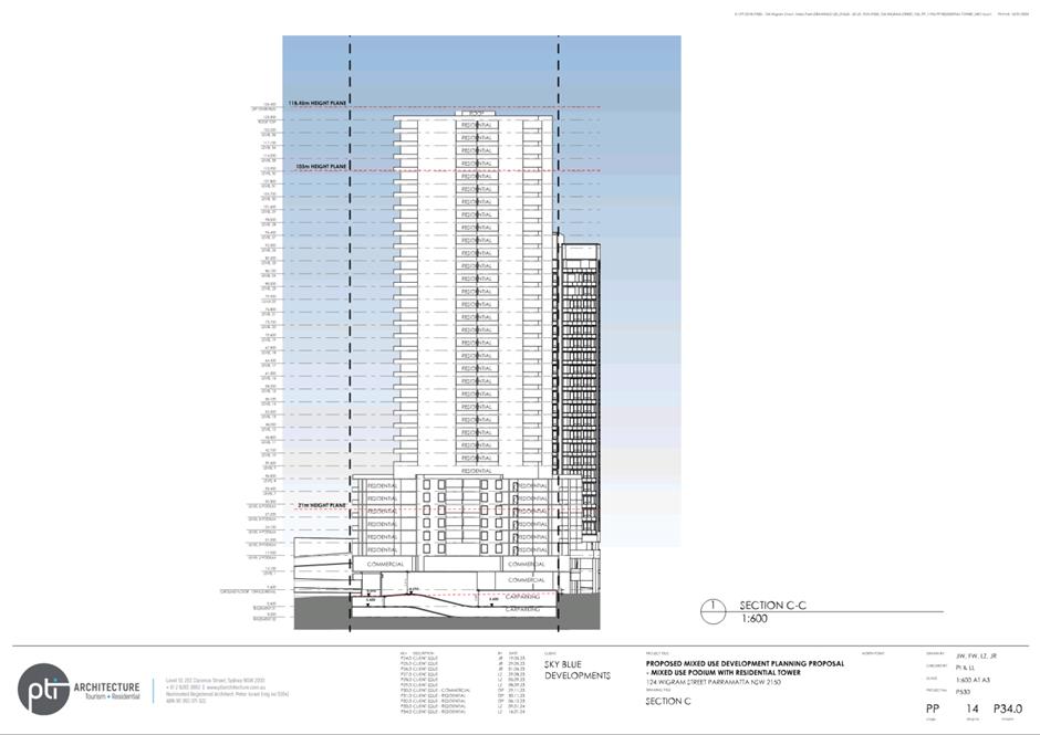
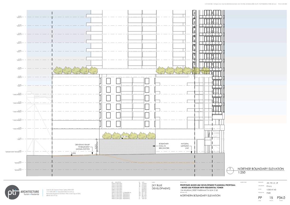
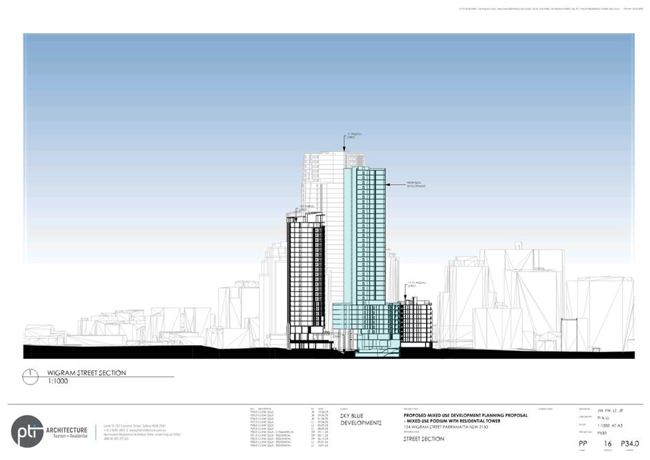
to the site.
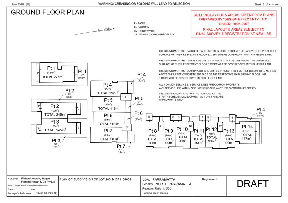
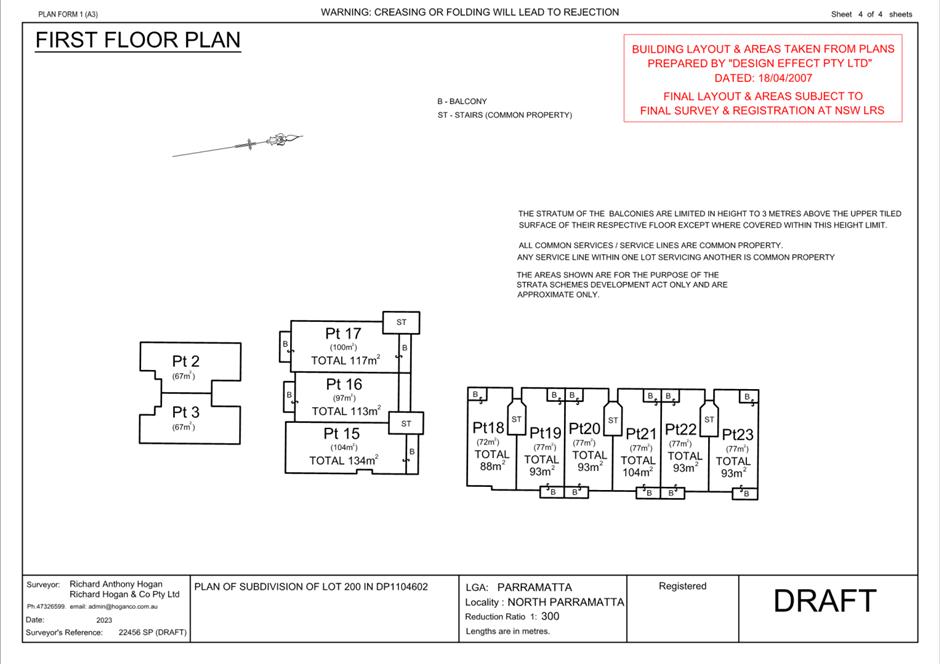
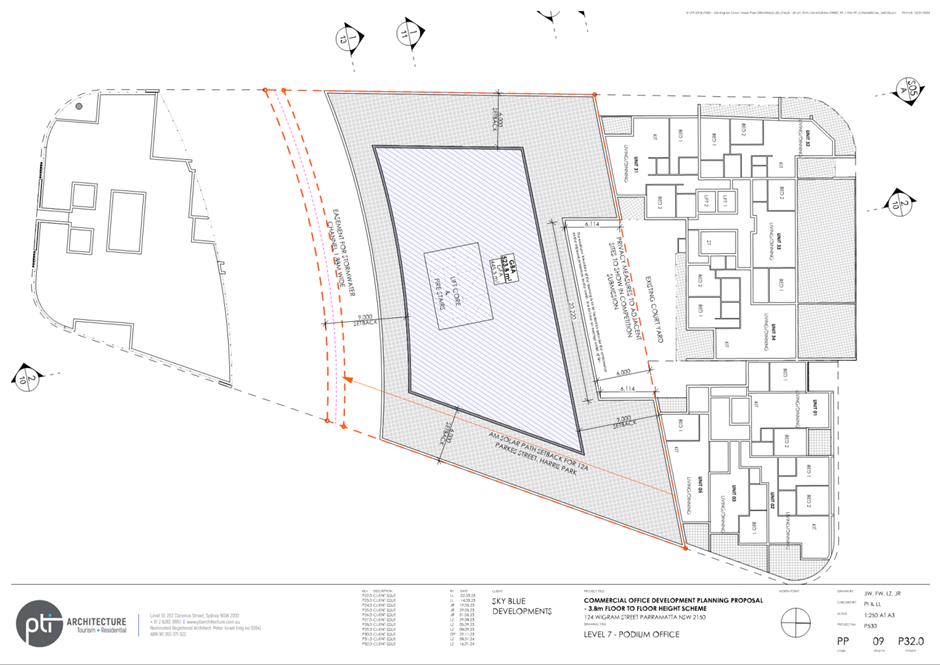
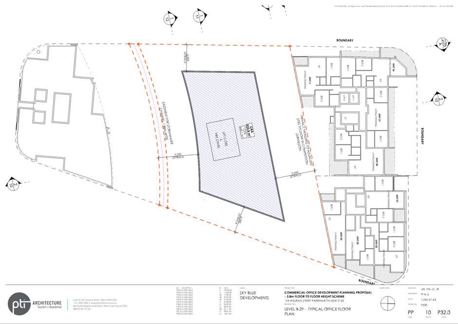
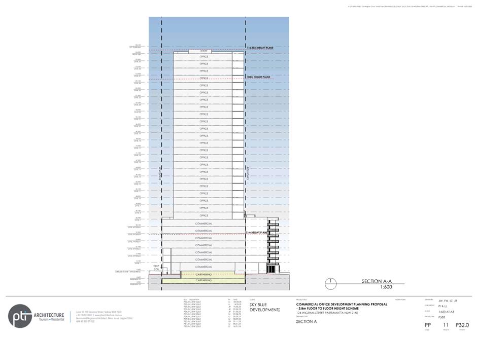
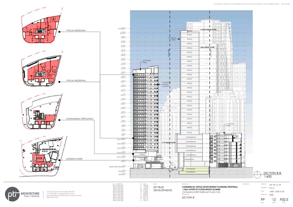
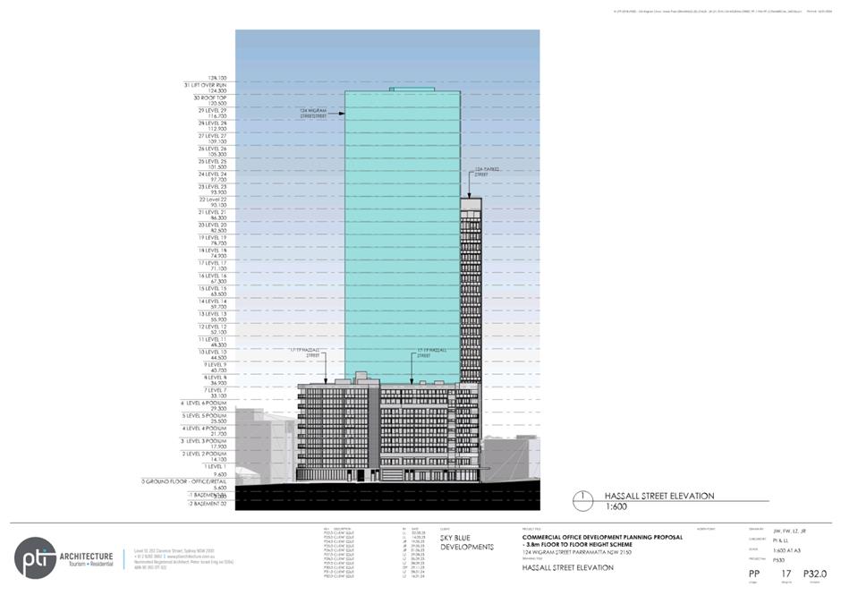
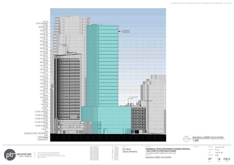
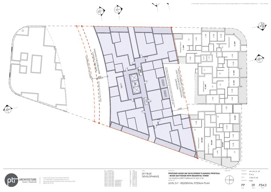
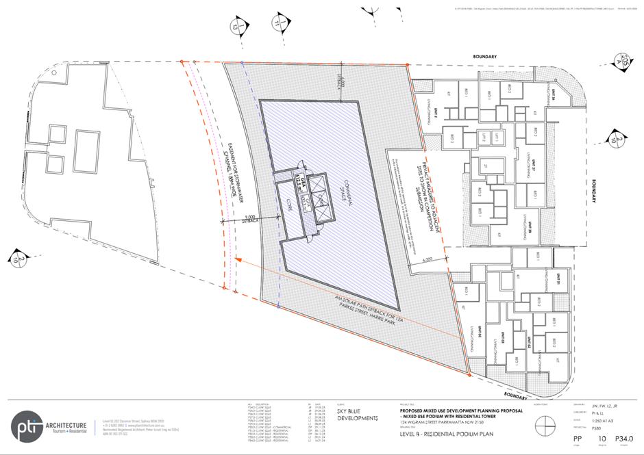
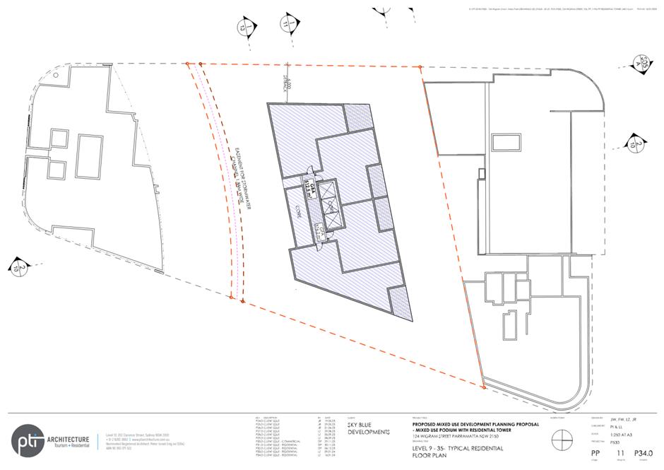
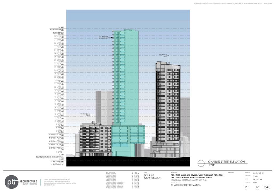
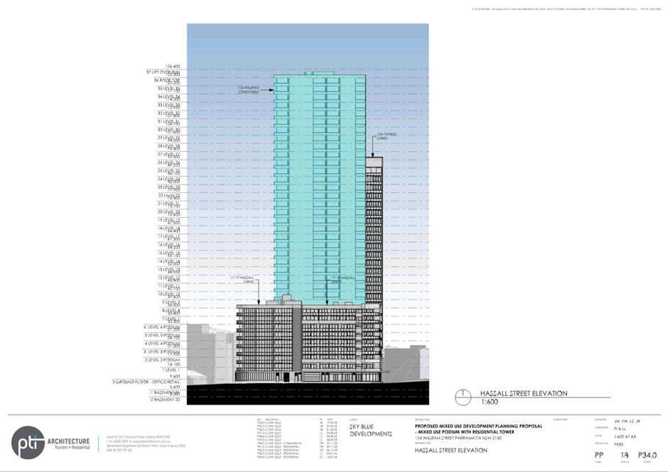
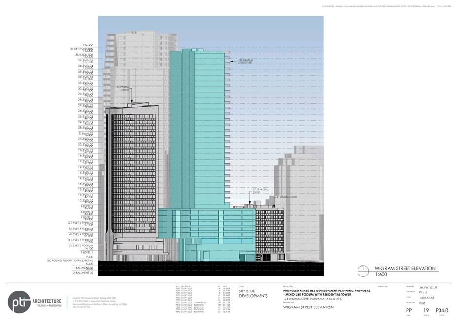
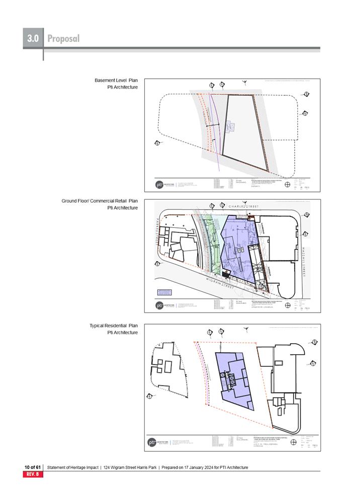
In this instance the portion of the proposal located on R2 zoned land
proposes Strata Subdivision of existing units measuring between 87m2
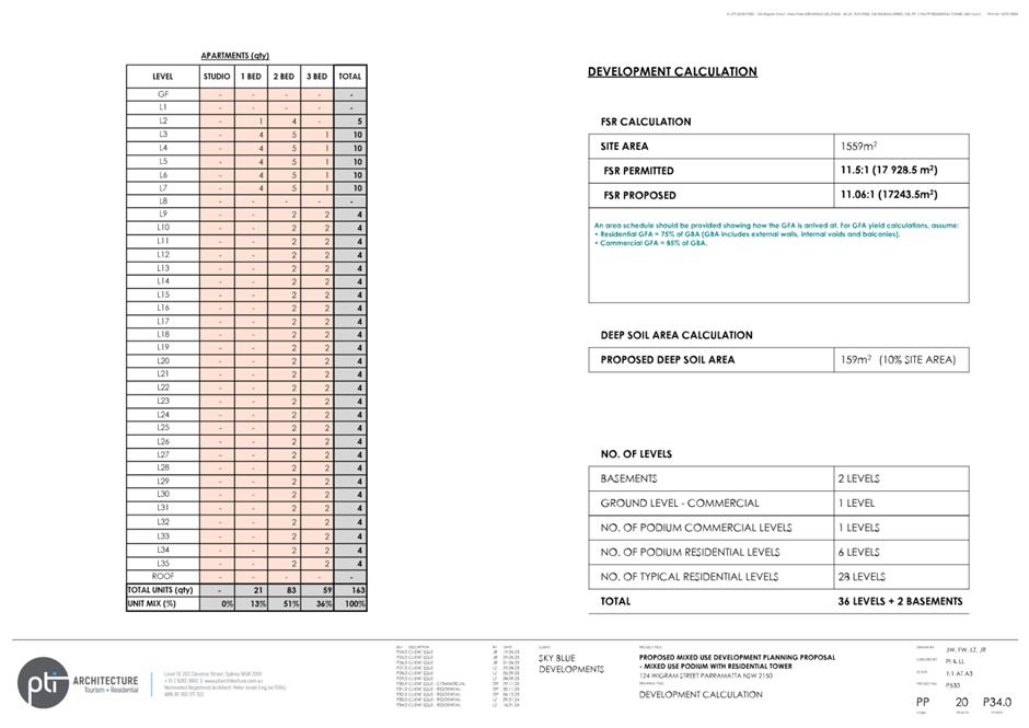
to 137m2. This results in a variation of 84.2% (or 463m2)
to the control. The application has been referred to the Panel as the proposal
consists of the variation to a control that is greater than 10%.
EXECUTIVE SUMMARY
This is a summary of the full
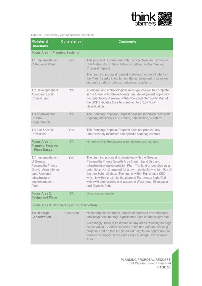
assessment of the application as outlined in Attachment 1, the Section 79C
Assessment Report.
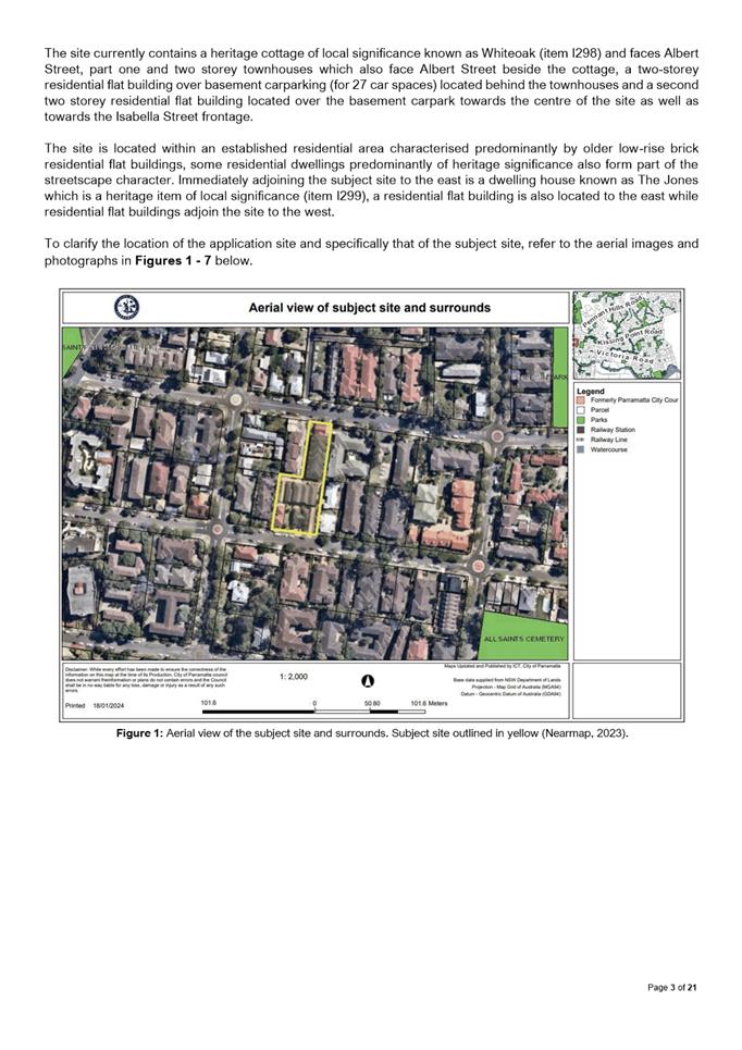
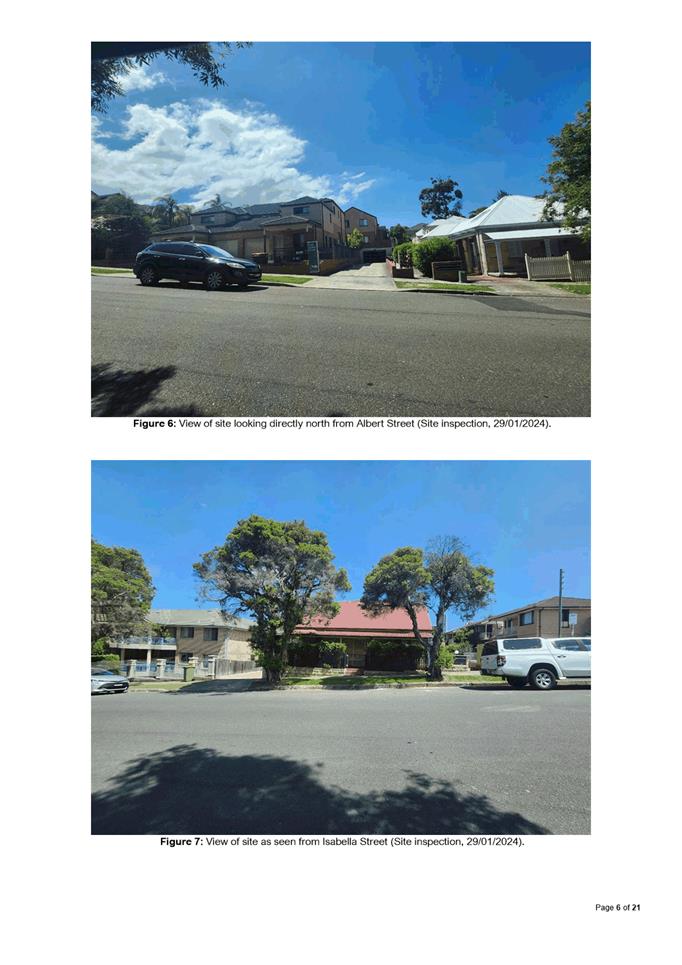
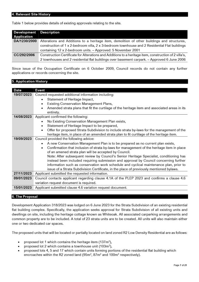
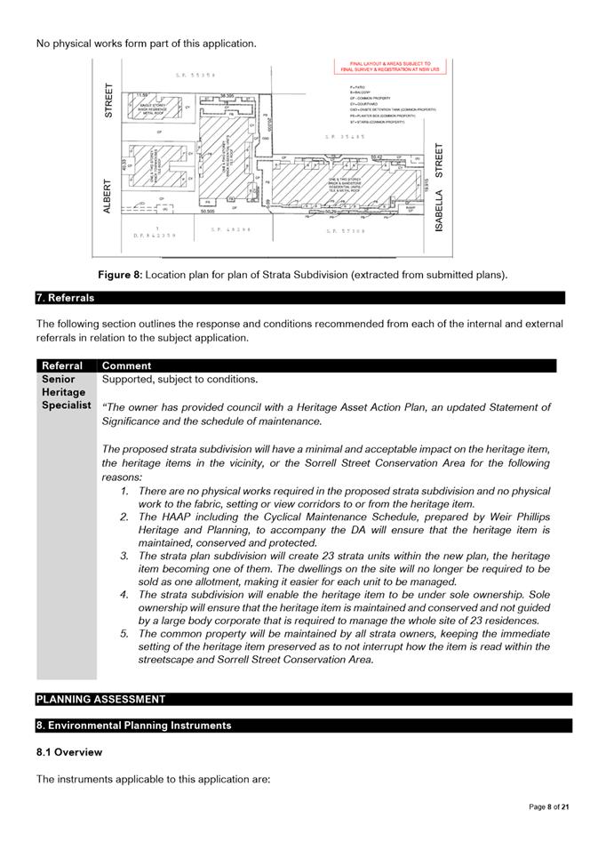
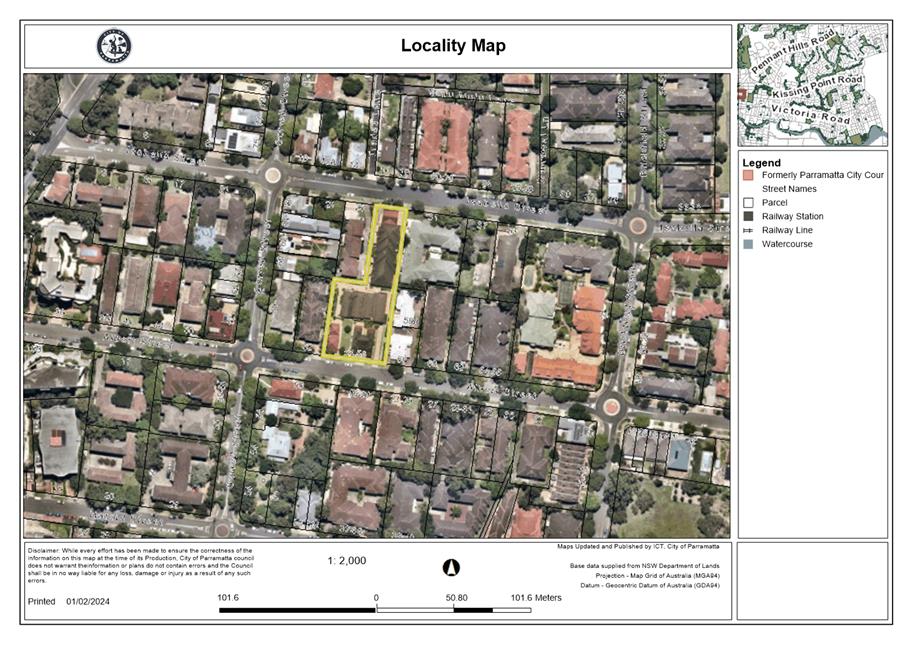
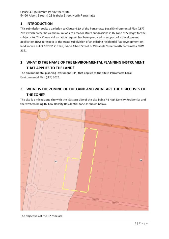
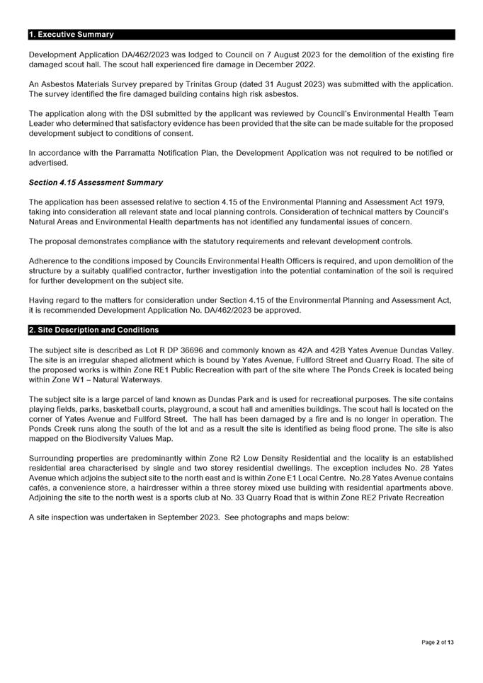
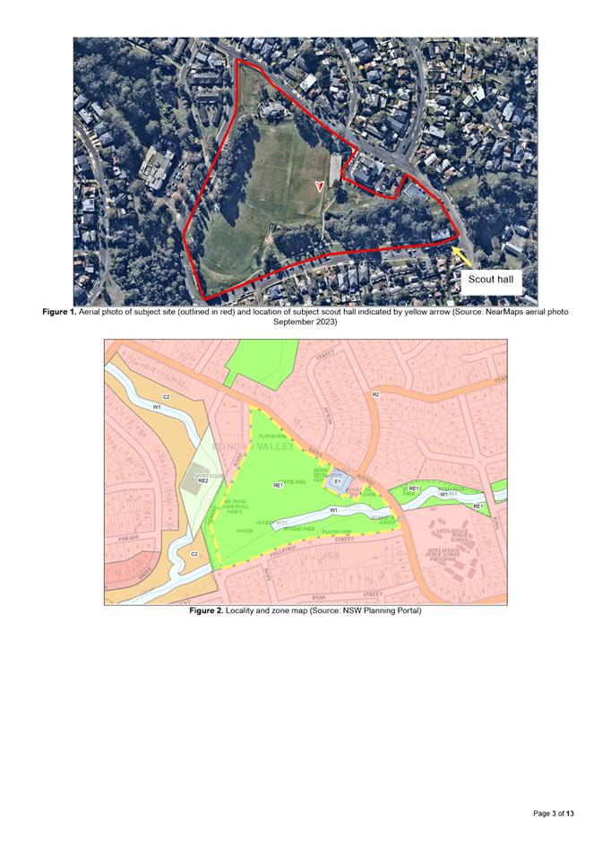
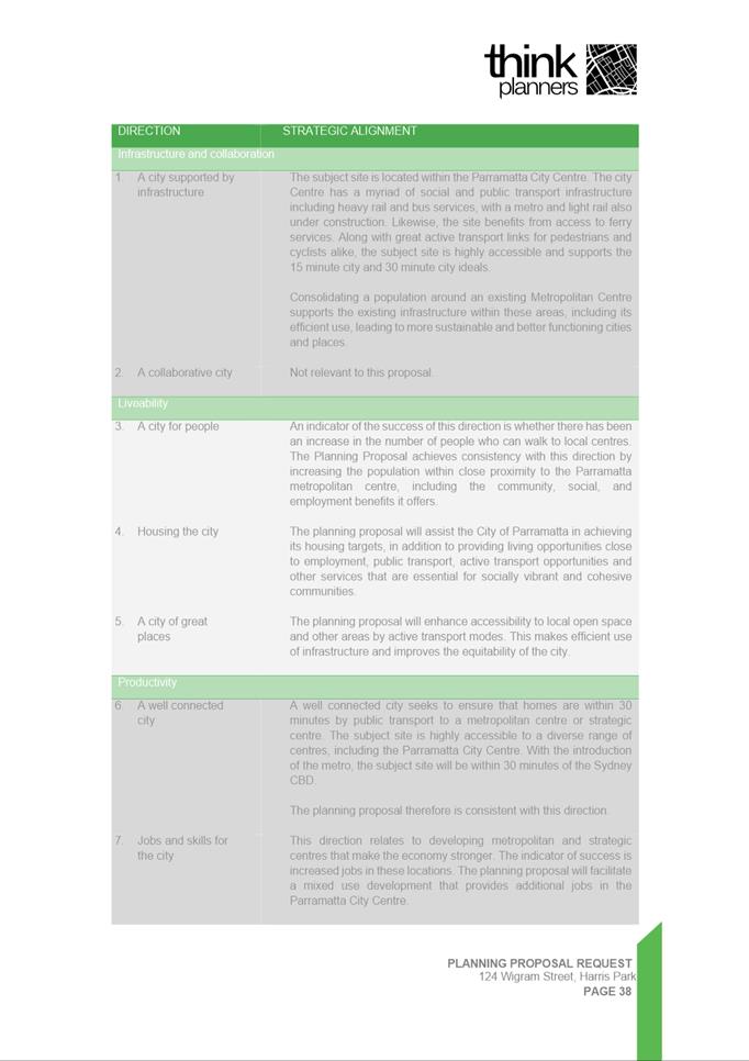
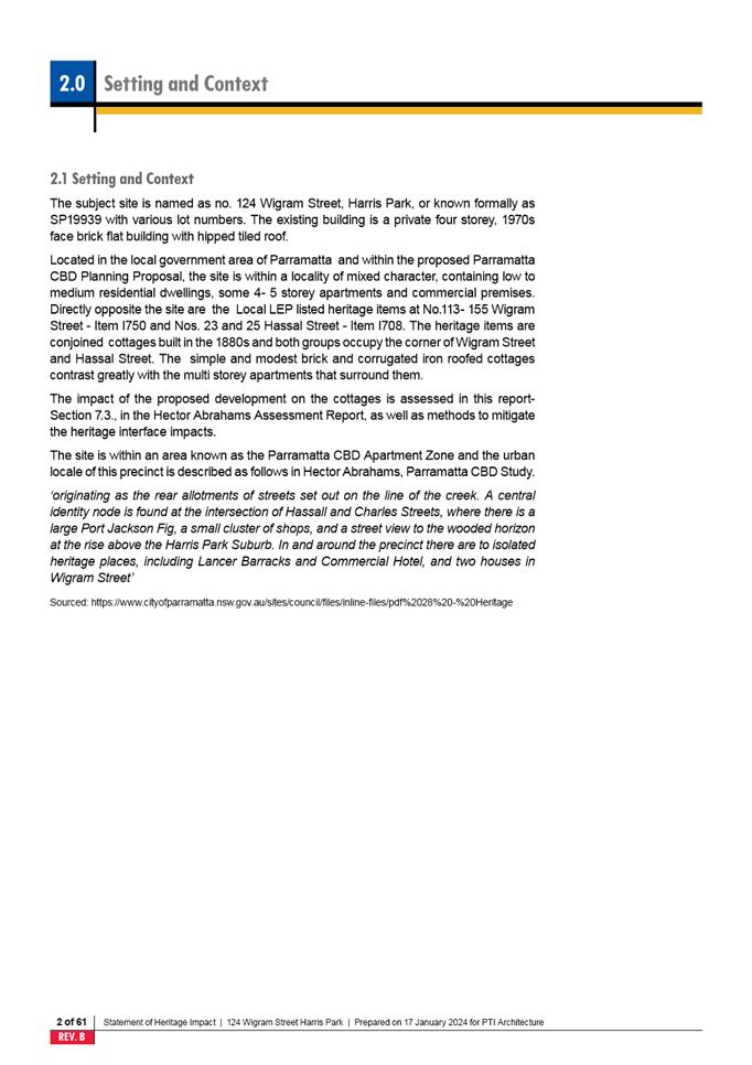
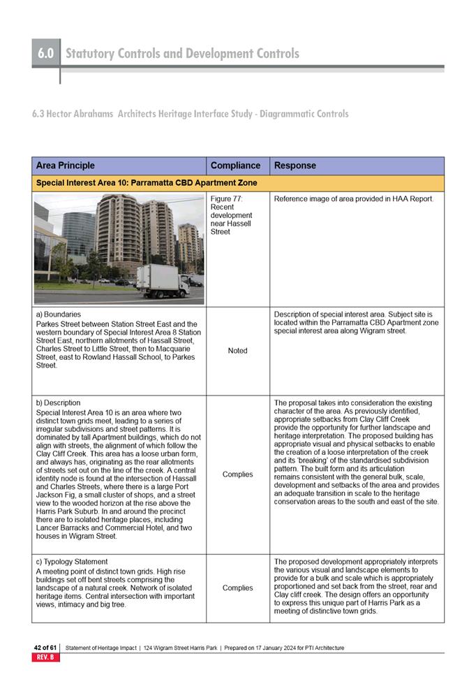
The subject site is known as 54-56 Albert
Street, North Parramatta. The site maintains two street frontages, each facing
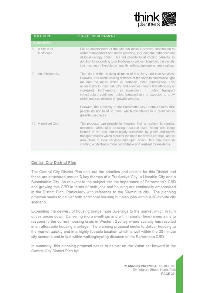
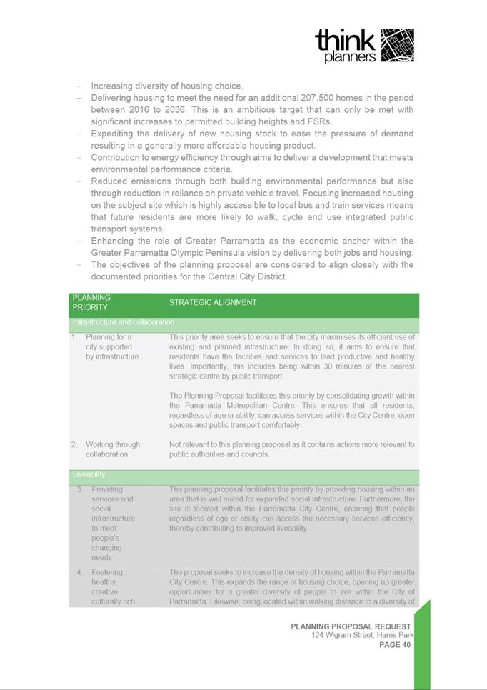
Albert and Isabel Streets. The site and surrounding properties are zoned a mix
of R2 Low Density Residential and R4 High Density Residential. Several heritage
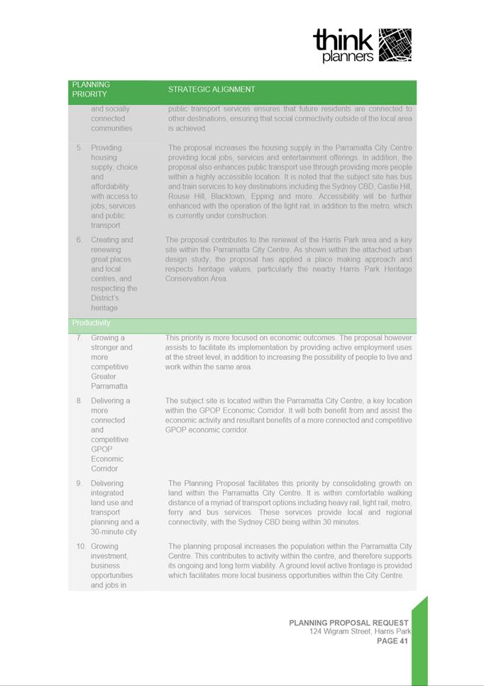
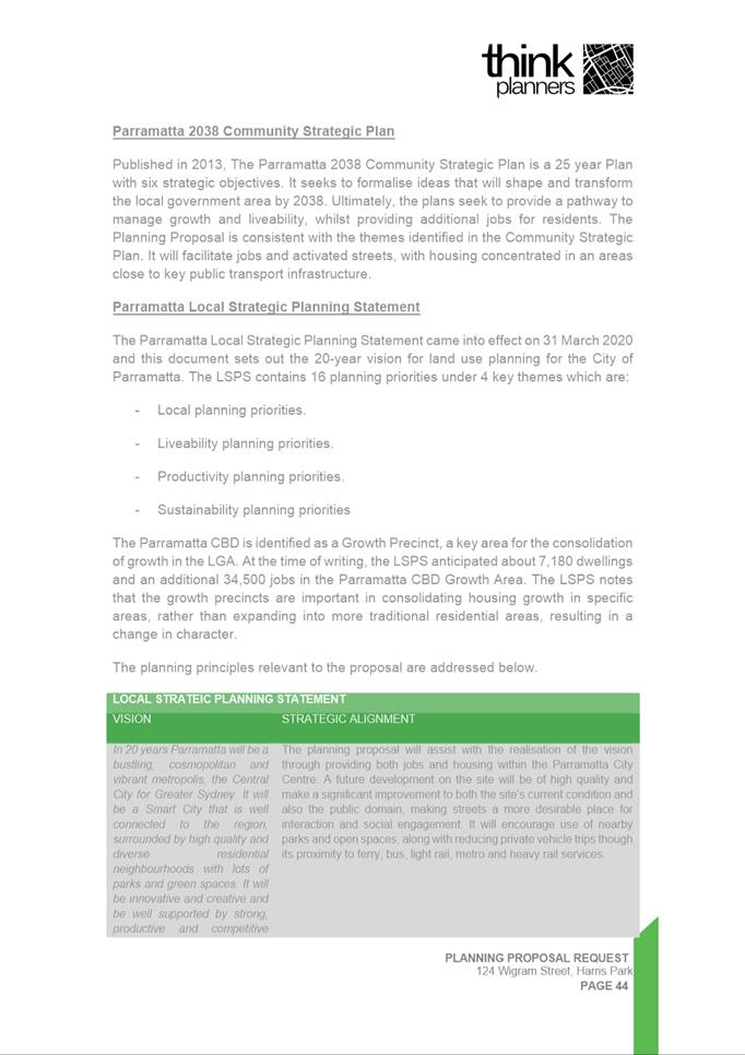
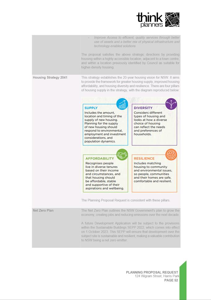
items are located throughout the immediate locality while the Sorrell Heritage
Conservation Area covers the site and areas towards the east which locates the
Sorrell Street corridor.
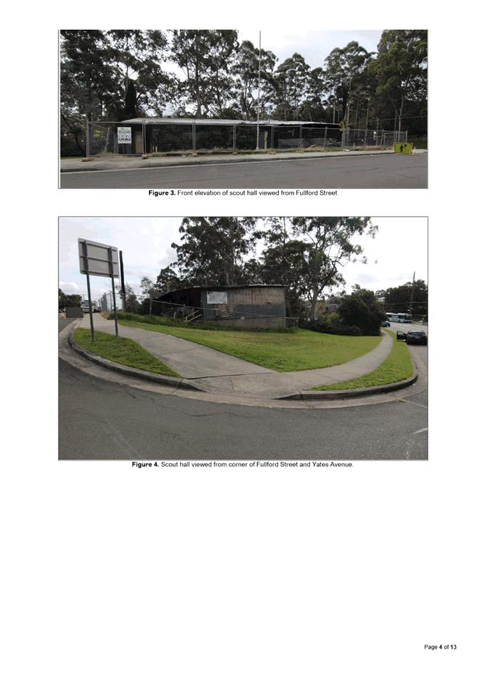
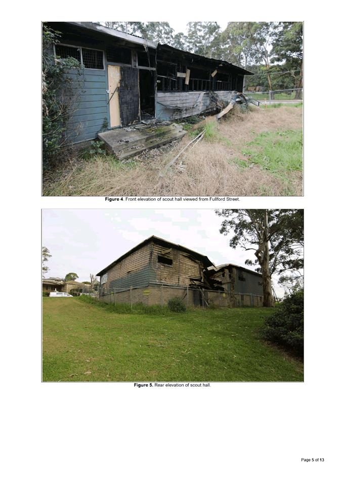
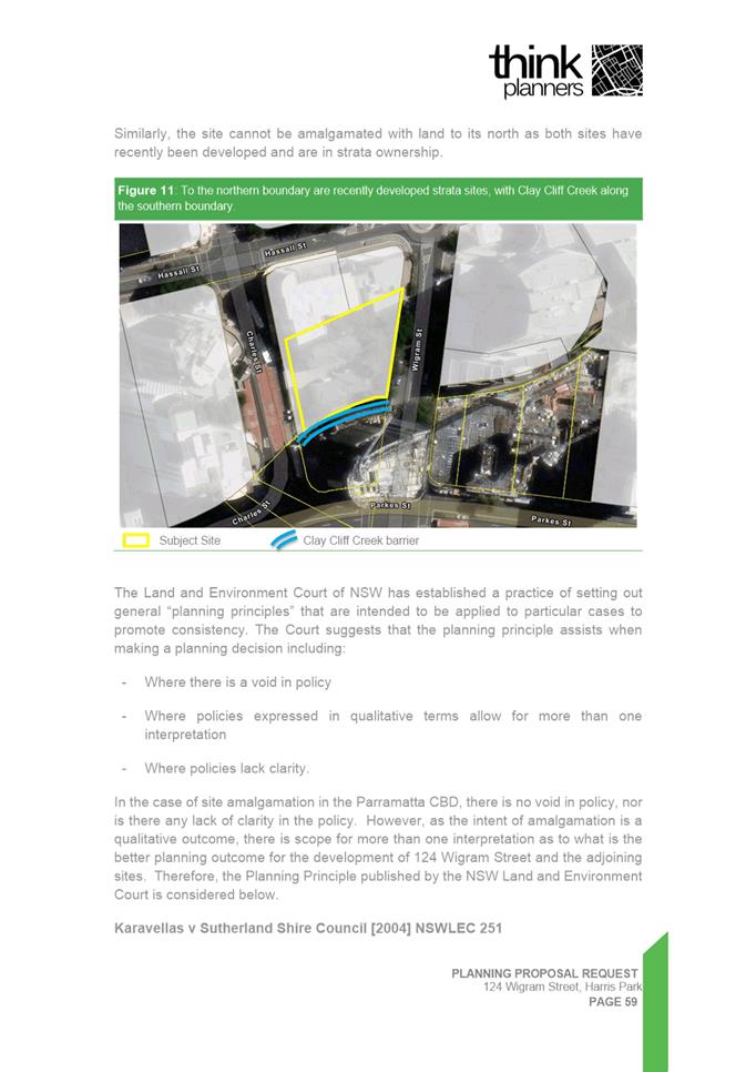
The site currently contains:
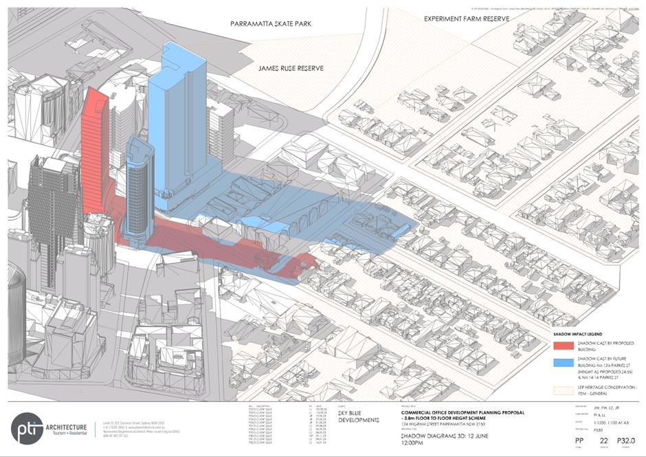
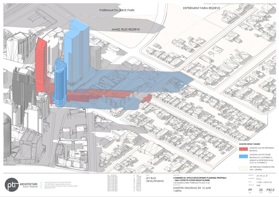
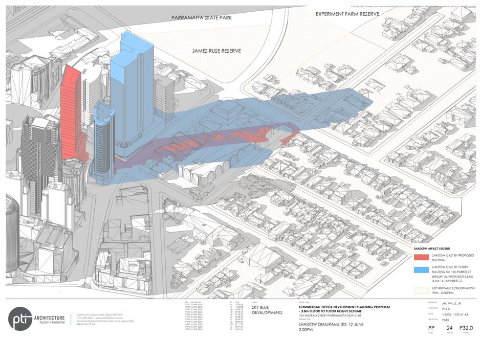
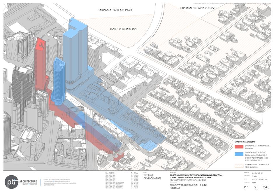
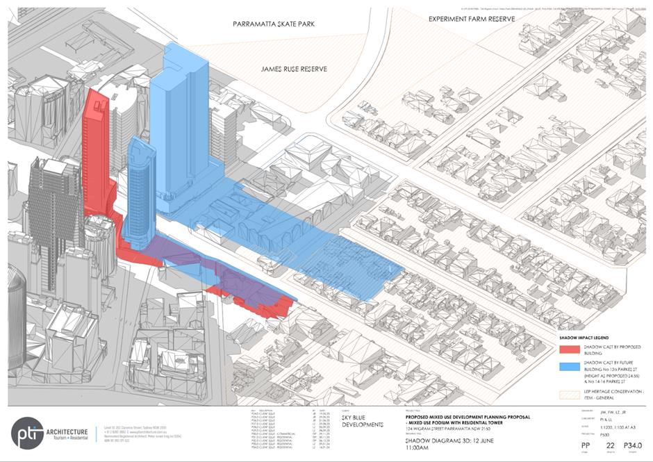
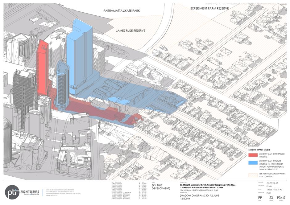
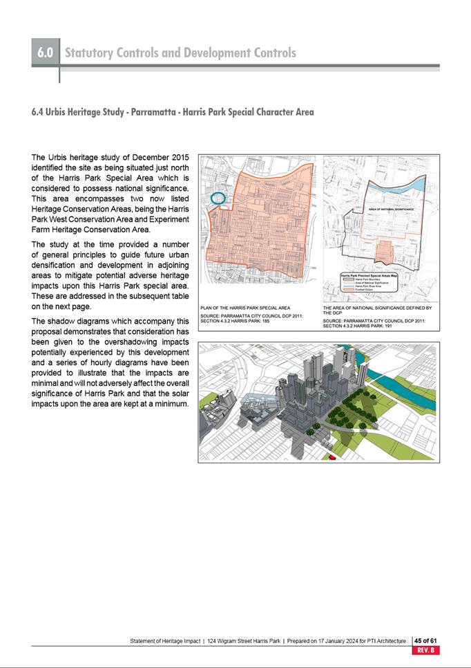
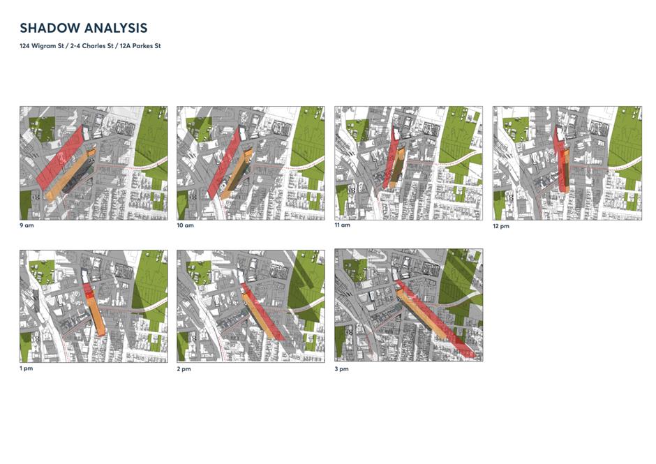
· A heritage cottage of local significance
known as Whiteoak,
· Part one and two storey townhouses located
beside the heritage cottage,
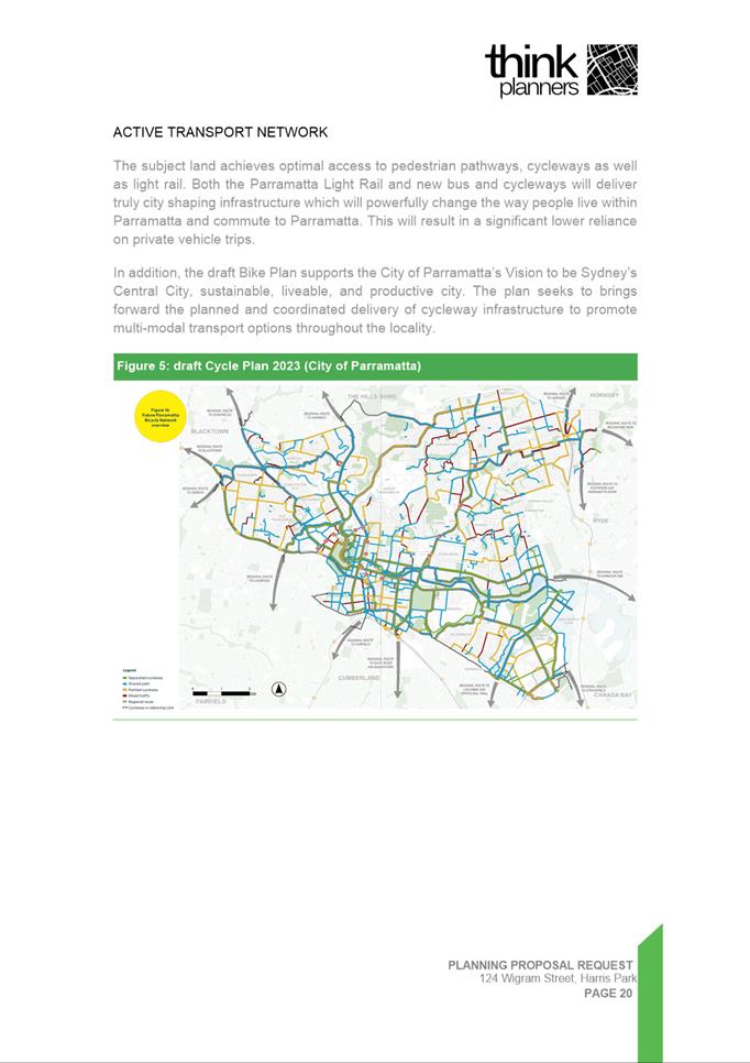
· A two-storey residential flat building
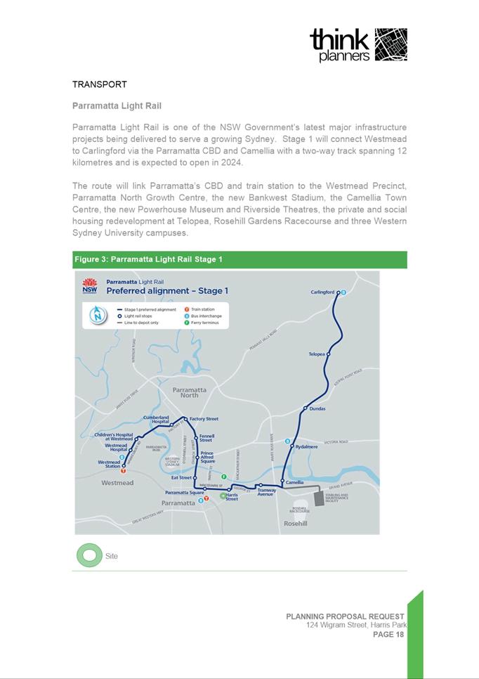
over basement carparking located behind the townhouses,
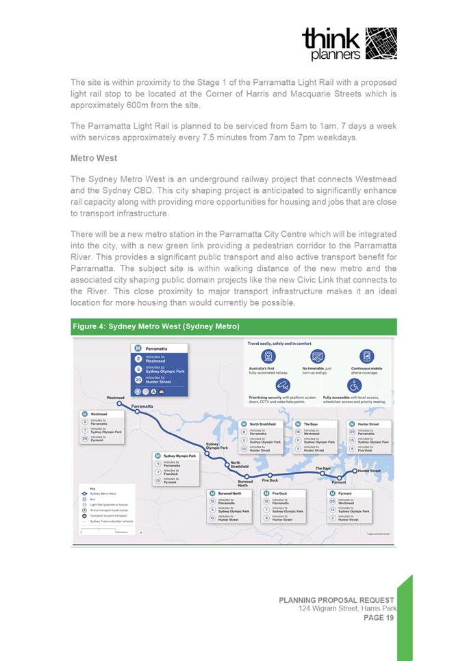
· A part one and two storey residential flat
building located over basement carparking, towards the centre of the site and
towards the Isabella Street frontage.
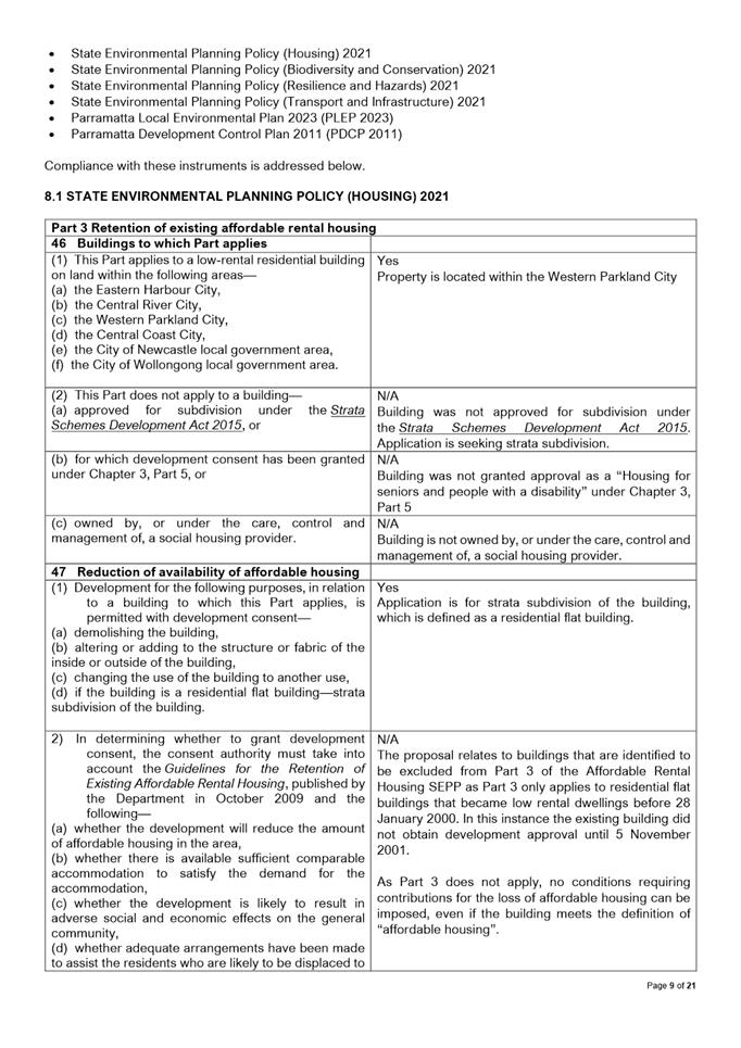
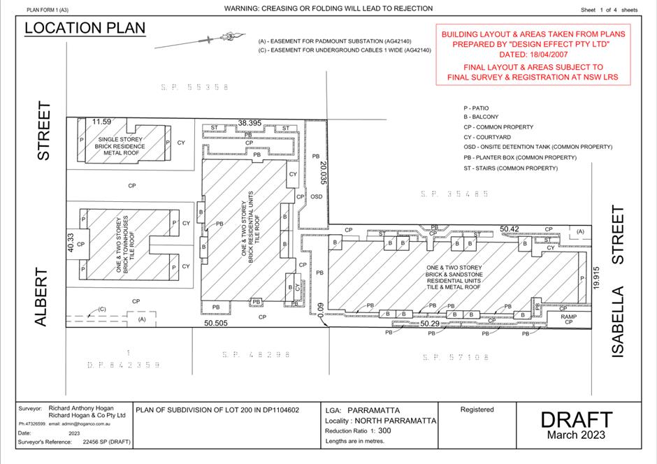
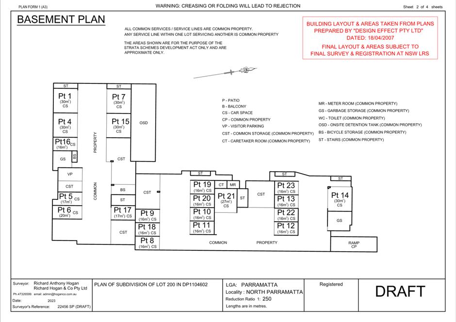
The proposed development is limited to the
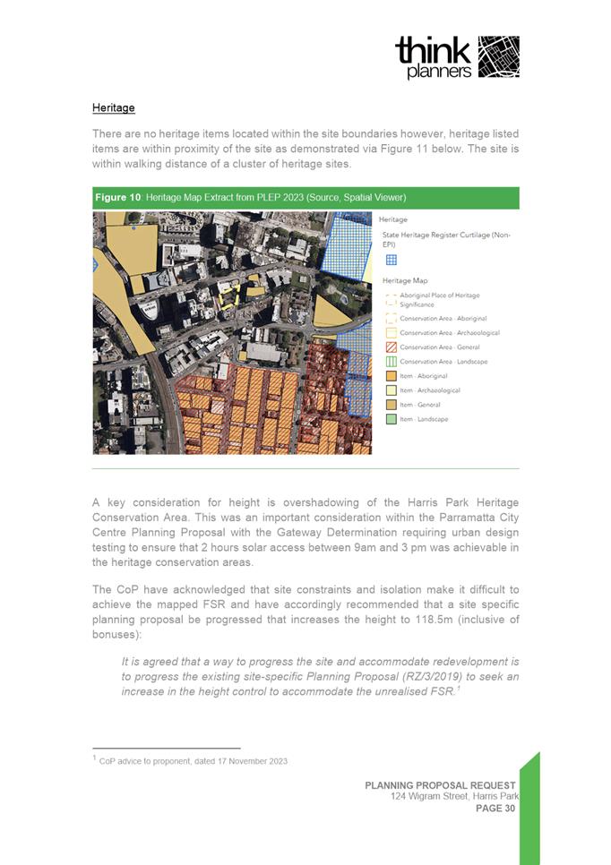
Strata Subdivision of the existing residential development and heritage item on
site. Specifically, the application seeks approval for the
subdivision of 23 strata units including:
· Unit 1 forming the existing heritage
cottage.
· Units 2-3 forming the existing townhouses.
· Units 4-23 forming the two existing
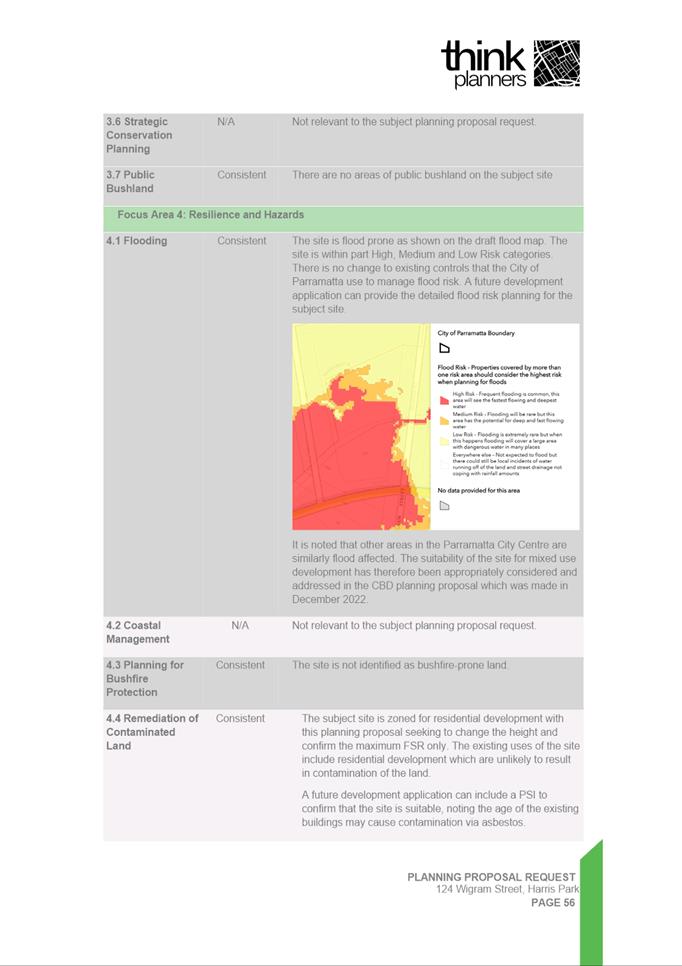
residential flat buildings.
All
associated carparking arrangements including 27 basement car spaces, and common
property such as the onsite detention tank, planter boxes and stairs are also
to be included.
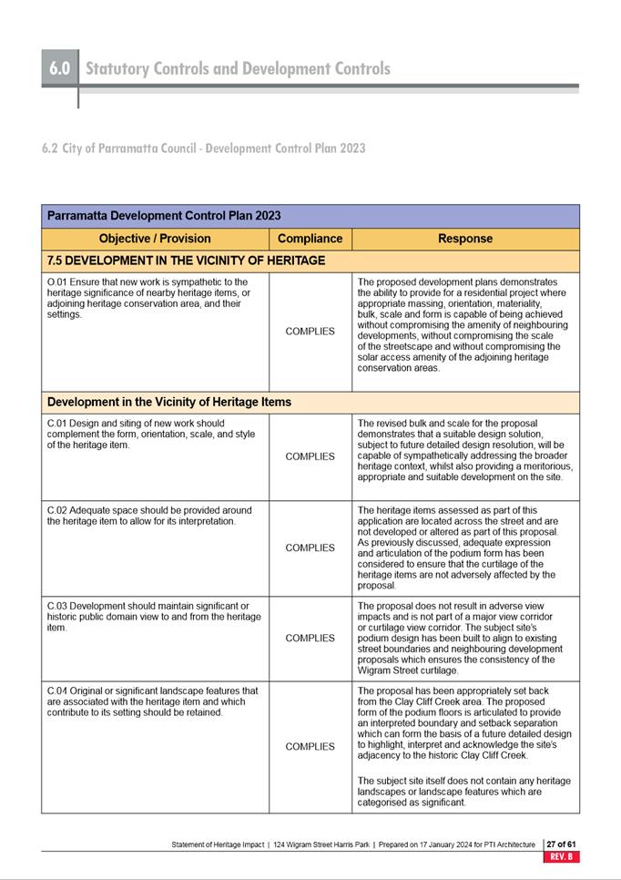
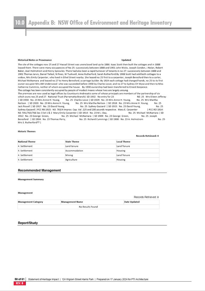
Section 4.15 Assessment Summary
The application has been assessed relative to section 4.15
of the Environmental Planning and Assessment Act 1979, taking into
consideration all relevant state and local planning controls.
As stated
above, the application relates to a residential flat building, approved prior
to the commencement of the PLEP 2023. A review of Councils records has
determined the site has employed and maintained the provisions of existing use
rights as the development is located on R2 Low Density Residential zoned land
which lists residential flat buildings as prohibited development. Furthermore,
as the site is affected by R2 Low Density Residential zoned land, clause 4.1A
of the PLEP 2023 applies to the proposal. It is noted however that only the
specific portions of the site zoned R2 Low Density Residential are subject to
this clause, land zoned R4 High Density Residential and the proposed strata
units located entirely within this land remain unaffected.
Clause 4.1A
of the Parramatta Local Environmental Plan 2023 (PLEP 2023) requires any Strata
Subdivision on land zoned R2 to result in lots not less than 550m2 (the
minimum lot size for the site).
In this
instance the proposal will result in subdivision of lots measuring down to 87m2
which represents a variation of 84.2% (or 463m2) to the PLEP 2023
control.
The proposal
has been accompanied by a Clause 4.6 variation request prepared by the
applicant which demonstrates that compliance with the clause is unreasonable
and unnecessary within the circumstances of the case. The variation has been
reviewed by Council who supports the variation.
Having regard to the matters for consideration under Section
4.15 of the Environmental Planning and Assessment Act 1979, it is
recommended Development Application No. DA/318/2023 be approved. The
recommended conditions of consent are within Attachment 1.
RECOMMENDATION
That the
Parramatta Local Planning Panel, exercising the function of the consent
authority, approve development consent to DA/318/2023 for the Strata
Subdivision of Existing Residential Flat Building Complex on land at 54-56 Albert Street, North
Parramatta.
REASONS FOR APPROVAL
1. The development maintains provisions for
existing use rights.
2. The development is permissible in the R4
zone pursuant to the Parramatta Local Environmental Plan 2023 and maintains
existing use rights pursuant to the Environmental Planning and Assessment
Act 1979.
3. The development will be compatible with the
emerging and planned future character of the area.
4. The development will continue to provide
housing that accommodates the needs of the existing and future residents,
workers and visitors of Parramatta.
5. For the reasons given above,
approval of the application is in the public interest.
Cade Tracey
Development Assessment Officer
Attachments:
|
1⇩ 
|
Assessment Report and Draft Conditions
|
25 Pages
|
|
|
2⇩
|
Locality Map
|
1 Page
|
|
|
3⇩
|
Plan of Strata Subdivision
|
4 Pages
|
|
|
4⇩
|
Clause 4.6 statement
|
13 Pages
|
|
REFERENCE MATERIAL
Local Planning Panel 20 February 2024 Item
6.1
ITEM NUMBER 6.1
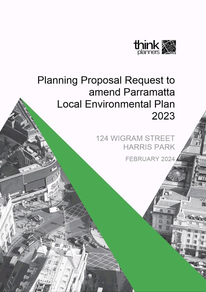
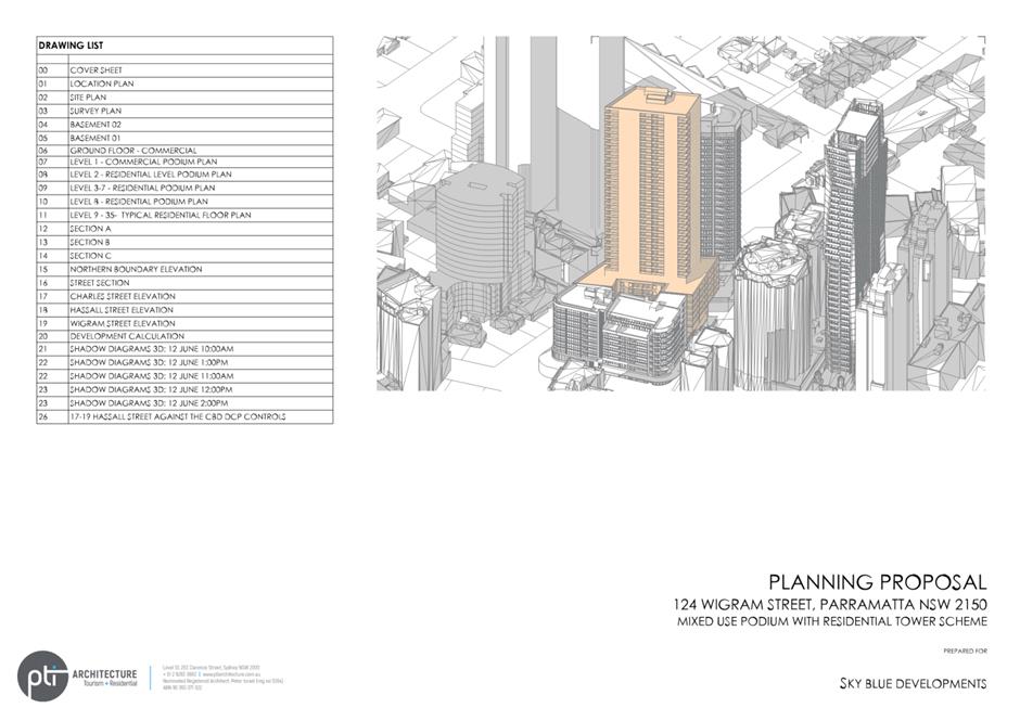
SUBJECT Gateway Request: Planning Proposal for land at 124 Wigram Street,
Harris Park
REFERENCE RZ/3/2019 -
APPLICANT/S Think Planners
OWNERS Charles Street Nominees Pty Ltd
REPORT OF Project Officer-Land Use
Development
applications considered by Sydney central city planning panel Nil
PURPOSE
To seek the Local Planning Panel advice on a Planning
Proposal for land at 124 Wigram
Street, Harris Park for the purposes of seeking a
Gateway Determination from the Department of Planning, Housing and
Infrastructure (DPHI).
RECOMMENDATION
That the Local Planning Panel consider the following
Council Officer recommendation in its advice to Council:
(a) That Council
approve, for the purposes of seeking a Gateway
Determination from the Department of Planning, Housing and Infrastructure
(DPHI), the Planning Proposal for land at 124
Wigram Street, Harris Park (Attachment 1) which seeks
to amend the Parramatta Local Environmental Plan 2023 (PLEP 2023) by amending
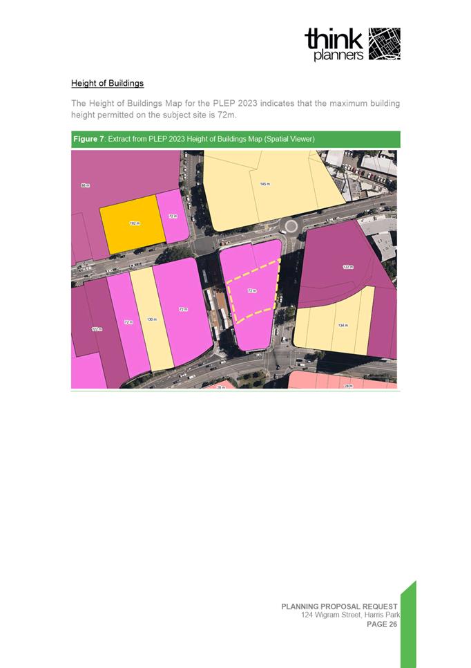
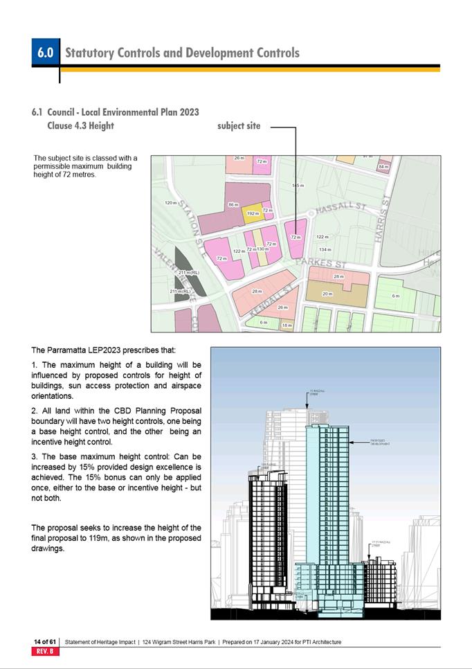
the PLEP 2023 Height of Building Map from 72 metres to
a maximum building height of 103 metres (118.45 metres including the design
excellence bonus).
(b) That Council request that the
DPHI address the flood matters detailed in this report by a condition on the
Gateway Determination.
(c) That Council request the DPHI
to provide Council with authorisation to
exercise its plan-making delegations for this Planning
Proposal.
(d) That Council authorise the CEO
to correct any minor anomalies of a non-policy and administrative nature that
arise during the plan-making process.
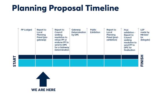
PLANNING PROPOSAL TIMELINE
SUMMARY
1. This
report seeks the advice of the Local Planning Panel on a Planning Proposal for
land at 124 Wigram Street, Harris Park for the purposes of seeking a Gateway
Determination from the DPHI.
2. The
Planning Proposal seeks to amend Parramatta Local Environmental Plan 2023 (PLEP
2023) to increase the height control from 72 metres to a maximum height of 103
metres to facilitate development of the site for high density commercial or
mixed-use development.
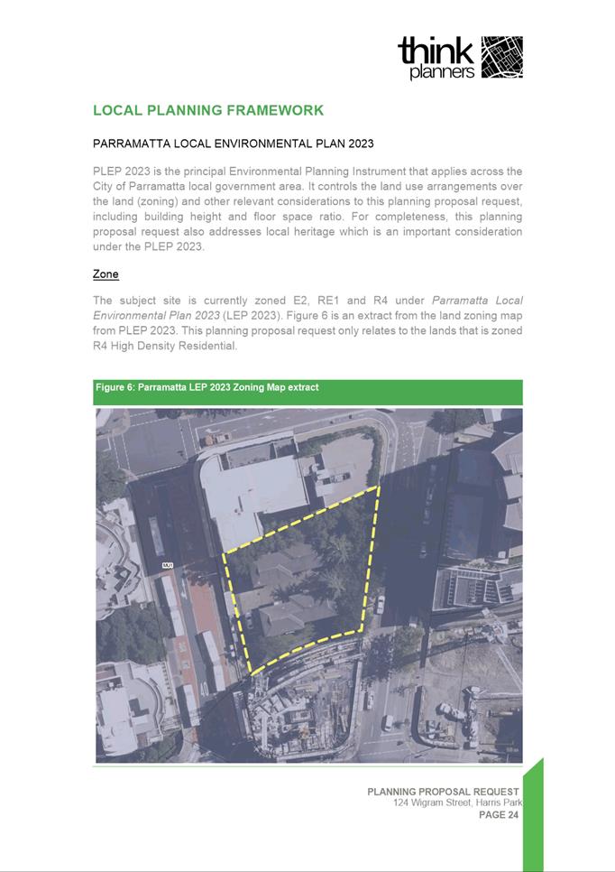
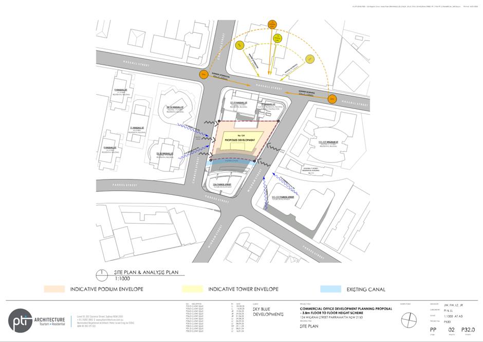
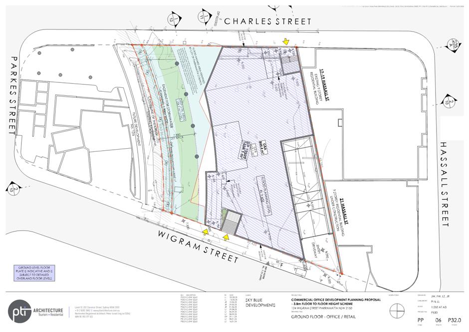
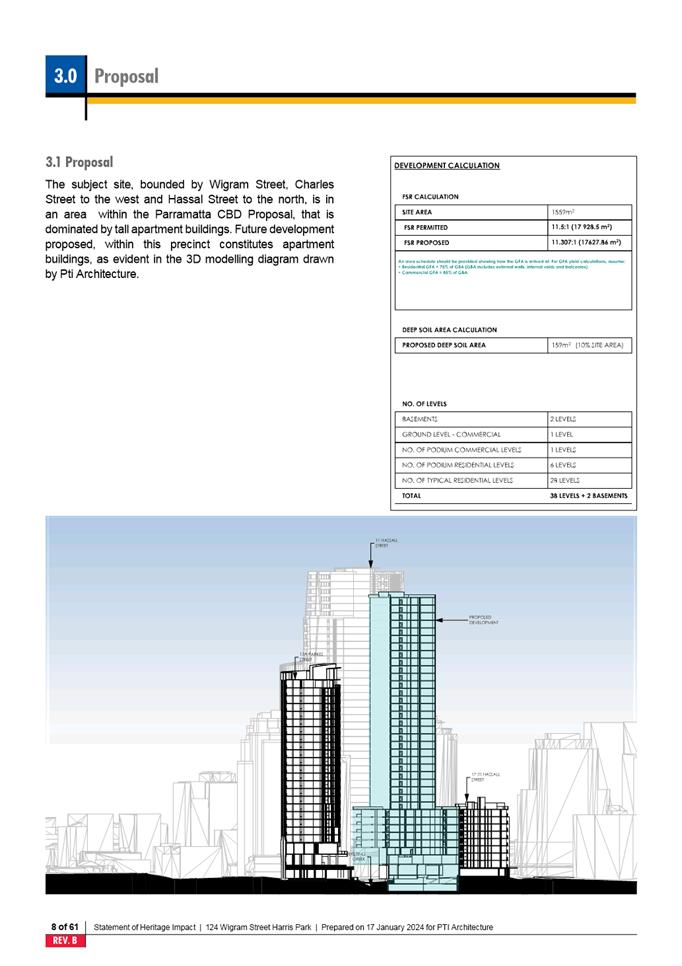
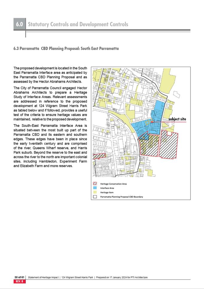
SITE DESCRIPTION
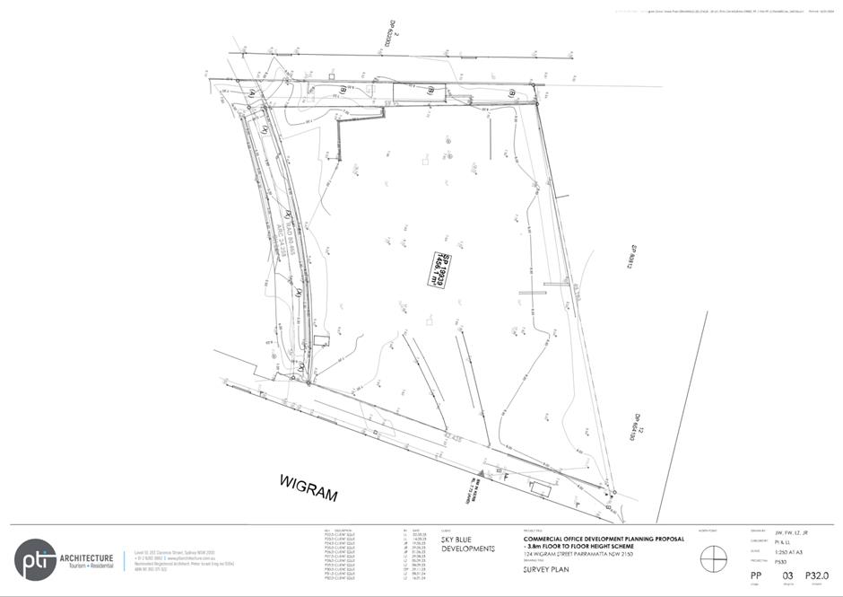
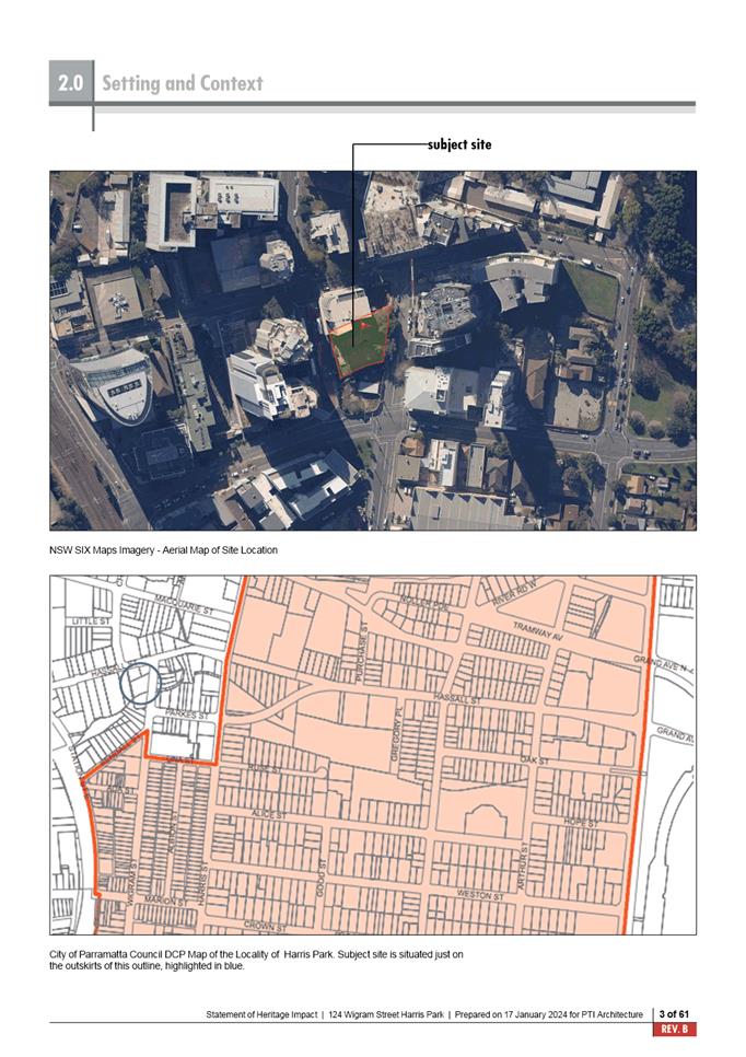
3. The
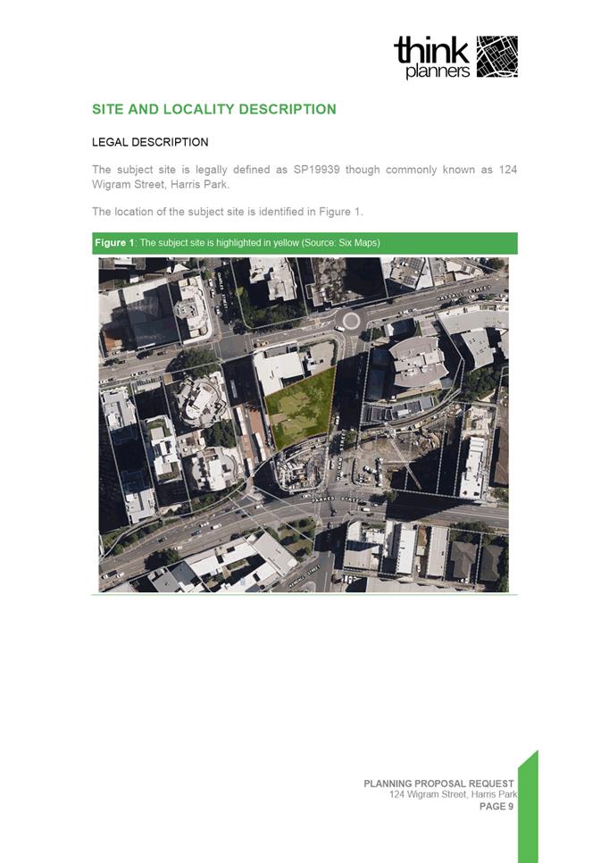
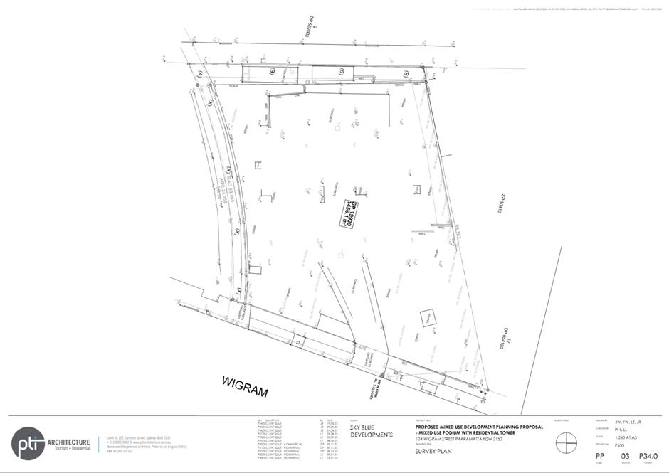
subject site is located at 124 Wigram Street, Harris Park and has a legal
property description of Strata Plan 19939 and part of Strata Plan 80813 (see Figure
1). The site includes a narrow section of land fronting Charles Street that
is currently part of the adjoining site to the north at 17-19 Hassall
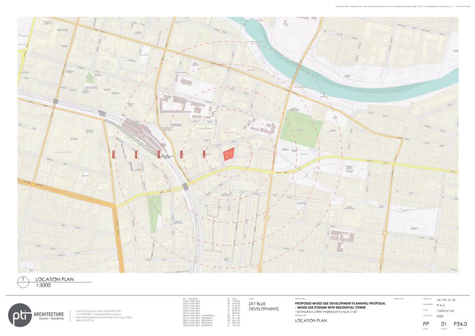
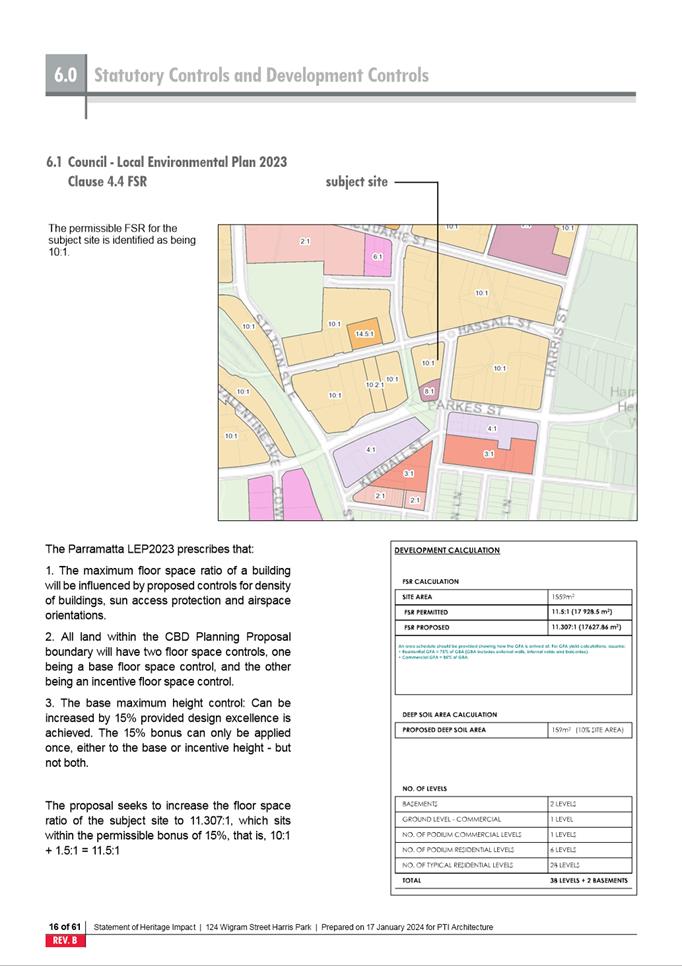
Street. The total site area is approximately 1,559 sqm.

Figure 1: Site location (City of
Parramatta GIS)
4. The
narrow section of land fronting Charles Street is subject to a development
consent (DA/342/2001) for a boundary adjustment between 17-19 Hassall Street
and 124 Wigram Street, Harris Park. The consent permits the incorporation of
this land within the site boundaries for 124 Wigram Street.
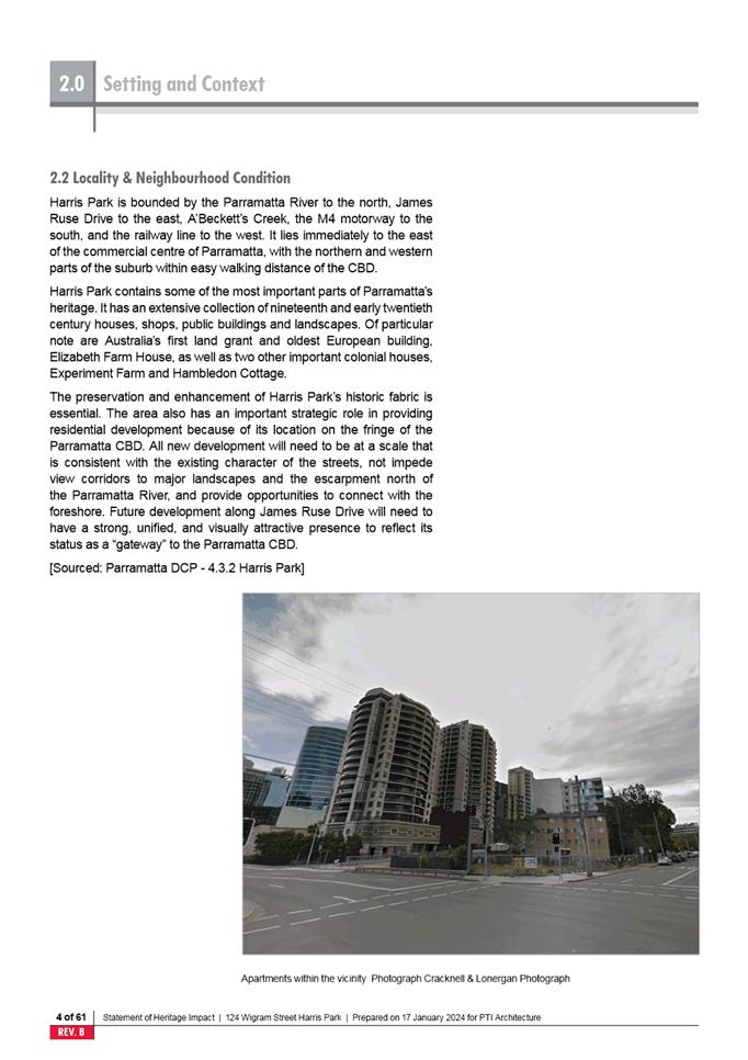
5. While
the site address is Harris Park, it is located on the south-eastern edge of the
subject area for the recently completed Parramatta CBD Planning Proposal.
The site is currently developed with two, three-storey residential flat
buildings estimated to have been built in the late 1970s/early 1980s.
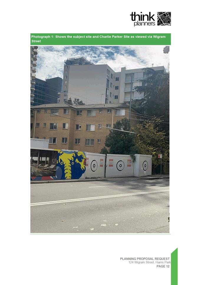
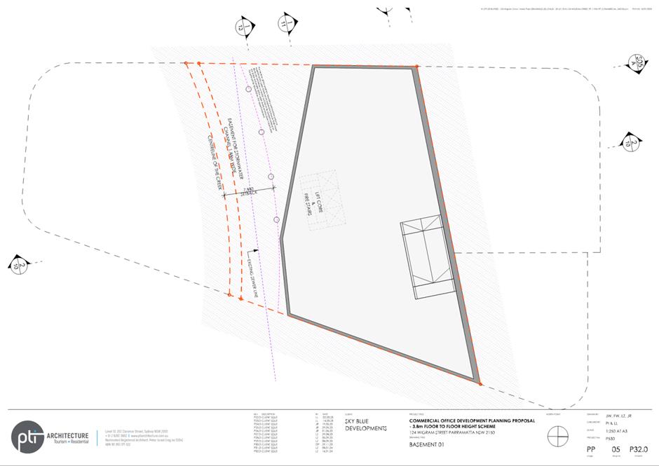
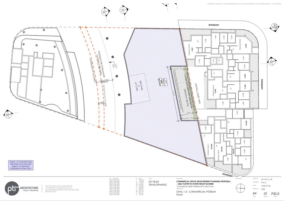
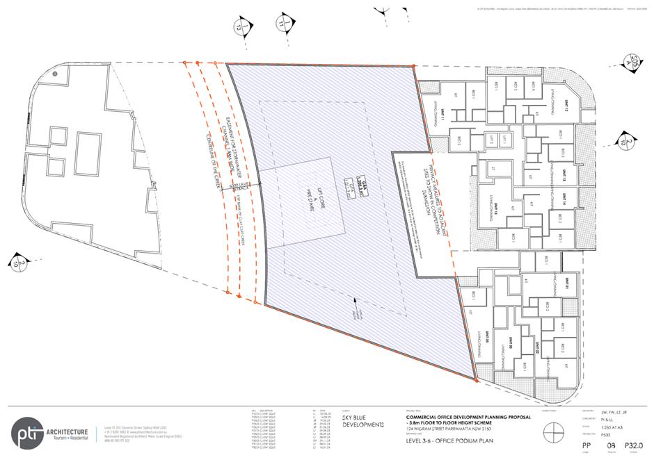
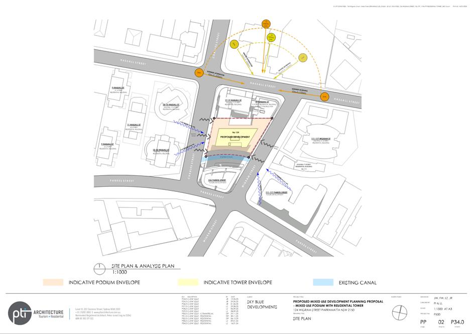
6. Clay
Cliff Creek runs along the southern boundary of the site and is a fully lined
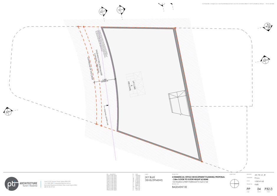
concrete channel for this part of the creek (see Figure 2 below).
Immediately to the south of the site on the other side of the concrete channel,
at 12a Parkes Street, is a recently constructed 24 storey residential apartment
building marketed as “Charlie Parker”. To the west of the site on
Charles Street is a bus layover used by bus services queuing for the Parramatta
interchange (see Figure 3 below). To the north
of the site, 17-19 and 21 Hassall Street both contain 9 storey apartment
buildings. The land on the northern side of Hassall Street at 2-4 Charles
Street is zoned for development to a maximum building height of approximately
50 storeys (166.75 metres).
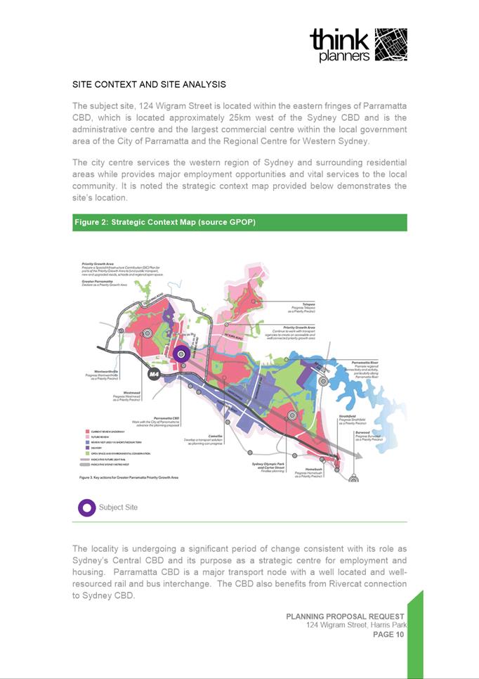
7. The
site is located south-east of Parramatta City Centre within close proximity to
employment opportunities, educational establishments, recreational activities,
and public transportation. This includes Westfield Parramatta, Arthur Phillip
High School, Parramatta Public School, Macarthur Girls High School, the
Parramatta Transport Interchange, Harris Park Railway Station, and Parramatta
Ferry Wharf.
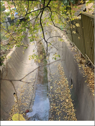
Figure 2: Clay Cliff Creek (Source: Think Planners
- Planning Proposal January 2024)
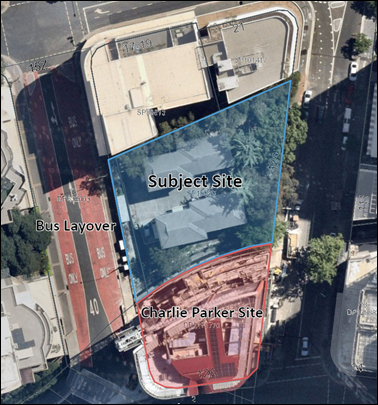
Figure 3:
Site aerial (Source: City of Parramatta GIS)
BACKGROUND
8. In
September 2019, Think Planners lodged a Planning Proposal with the City of
Parramatta Council for land at 124 Wigram Street, Harris Park seeking to
increase the density of development permitted within the MU1 Mixed Use zoning
of the site (then B4 Mixed Use). The Planning Proposal sought to increase the
floor space ratio (FSR) from 6:1 to 11.5:1 (including the 15% design excellence
bonus). It also sought to remove the height control of 72 metres within the
Incentive Height of Building Map.
9. Council
Officers raised several concerns with the reference design submitted with the
Planning Proposal and an assessment of the Proposal indicated that the site
would receive similar controls under the Parramatta CBD Planning Proposal which
was proposing to identify the site with a mapped FSR of 10:1. As a result, the
applicant was advised to commence the preparation of a Design Competition brief
noting that the Parramatta CBD Planning Proposal was likely to provide the
controls they were seeking.
10. The applicant
submitted a draft Design Competition brief in December 2021 but this was not
progressed due to non-compliance with the setbacks within the draft Development
Control Plan (DCP) for the Parramatta CBD Planning Proposal area.
11. On 6 May
2022 Amendment 56 to Parramatta Local Environmental Plan 2011 (PLEP 2011) was
notified which confirmed the changes to be brought into effect under the
Parramatta CBD Planning Proposal. The changes to PLEP 2011 took effect on 14
October 2022.
12. State
Environmental Planning Policy (Parramatta CBD) (No. 2) 2022 was notified on 16
December 2022 which made further amendments to PLEP 2011 by permitting
development on certain sites in the Parramatta CBD (including the subject site)
to exceed the permitted FSR by 5% provided that the building meets certain
criteria, including that it is used for commercial purposes only.
13. Council wrote to the applicant on 21 March 2023 requesting they
withdraw the Planning Proposal on the grounds that Amendment 56 had delivered
the density being sought. The applicant subsequently advised that they
preferred not to withdraw the Planning Proposal until the setbacks were
resolved and the consequent development yield was known. At that time, the
applicant’s reference design indicated that a proposal that complied with
the DCP setbacks for the CBD would only be able to achieve an FSR of 7.57:1.
14. On 30 March 2023, the applicant submitted a draft site-specific DCP
seeking to vary the setbacks. The Council
Officer assessment confirmed that the current height control of 72 metres
(82.8m including design excellence bonus) does not provide the scope to achieve
the permissible FSR of 11.5:1. However, variation of the DCP setbacks to
overcome this issue was not considered acceptable due to the impacts on
surrounding development, noting the nature of residential development to the
north and south of the site. In this regard, it was considered preferable to
increase the permissible height control. Council Officers conducted urban
design analysis of the building heights in the locality and the cumulative
impacts of increasing the height control on the subject site and identified a
total height of 119 metres as being acceptable for the site.
15. In December
2023, the applicant submitted a revised Planning Proposal seeking to increase
the height control to permit a total height of 103 metres (118.45 metres including
the design excellence bonus).
CURRENT PLANNING CONTROLS
16. Under the
provisions of the PLEP 2023, the following planning controls apply to the
subject site:
a. Land Use
zoning: MU1 Mixed Use.
b. Maximum
Height of Buildings: 72 metres (mapped), 82.8 metres (including 15% design
excellence bonus).
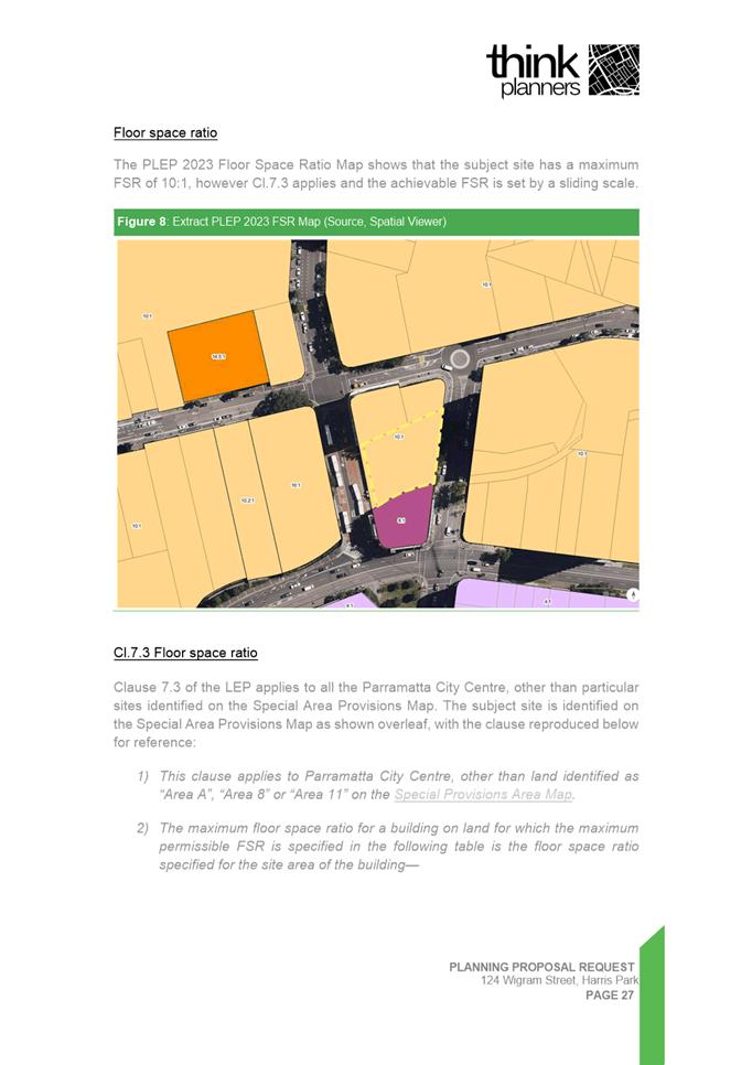
c. Floor Space
Ratio: 10:1 (mapped), 11.5:1 (including 15% design excellence bonus).
d. Sliding
scale provisions under Clause 7.3(2): these provisions apply to sites with a
site area below 1,800 sqm and reduce the permissible FSR for the subject site
to 8.795:1 (10.295:1 including design excellence bonus). However, there is
provision for sites identified as being isolated to be exempt from the sliding
scale provisions.
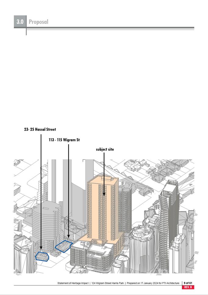
17. The site is
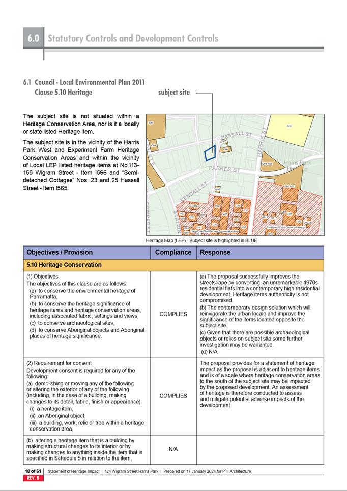
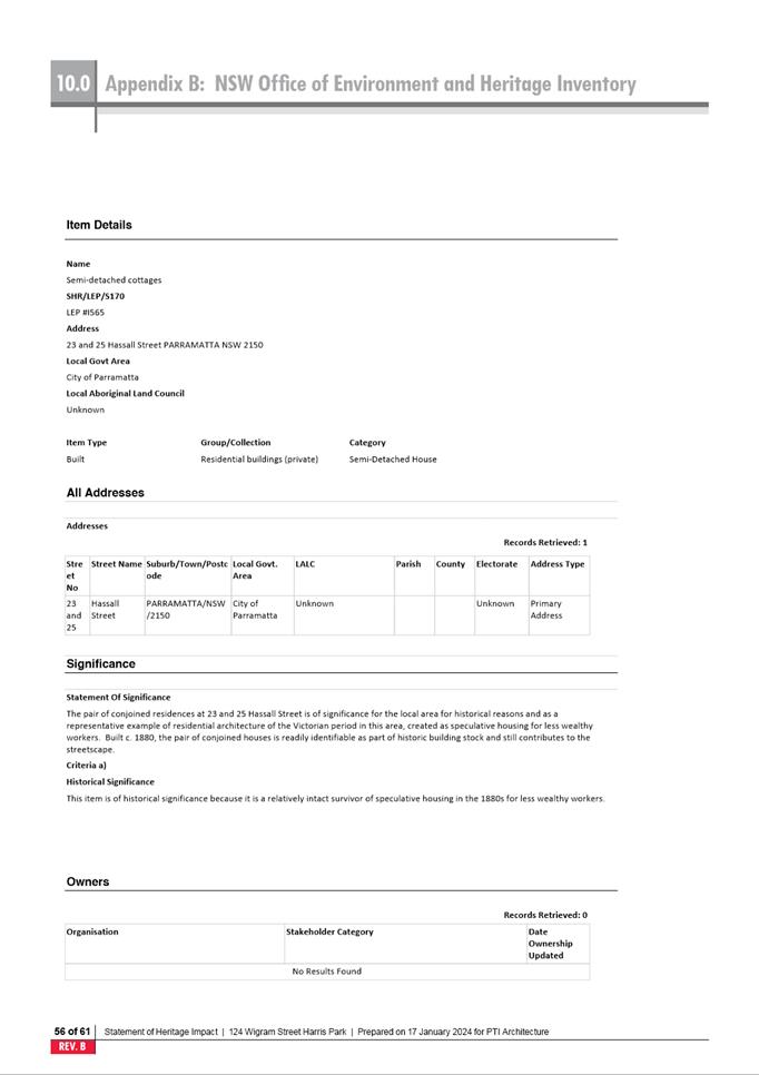
not heritage listed. There are two items of local heritage significance located
within proximity of the site being 23-25 Hassall Street and 113-115 Wigram
Street (Refer to Figure 4 below).
18. The Harris
Park West Heritage Conservation Area is located to the south of the site (Refer
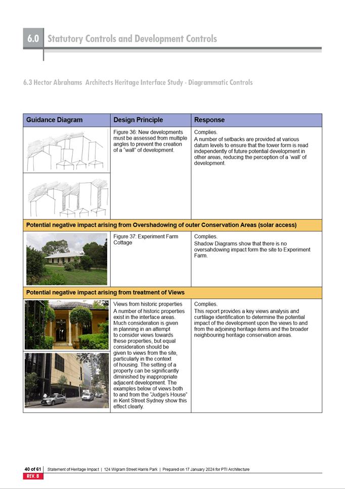
to Figure 5 below) and the Heritage Conservation Area for Experiment
Farm Cottage is located to the south-east.
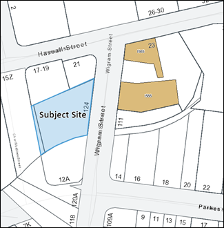
Figure 4: Heritage items within proximity of
subject site (shown in brown shading)
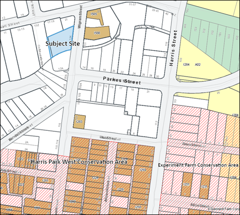
Figure 5: Heritage Conservation Areas to the south of subject site (shown in
red hatching)
DESCRIPTION OF PLANNING PROPOSAL
19. The Planning
Proposal seeks to amend the PLEP 2023 for the subject site by increasing the height control within the Height of Buildings
Map as described in Table 1 below.
Table 1:
Existing and proposed height controls
|
Control
|
Current
control
|
Proposed
control
|
|
Height
of Buildings
(Mapped)
|
72m
|
103m
|
|
Height
of Buildings
(Total
including 15% Design Excellence bonus)
|
82.8m
(24
storeys mixed use)
|
118.45m
(36
mixed use storeys)
|
20. Figures 6 and 7 show indicative mixed use and commercial
buildings that could be achieved under the proposed height (See also Reference
Designs at Attachments 2 and 3). Figure 8 shows an indicative building under the existing height
controls of the PLEP 2023.
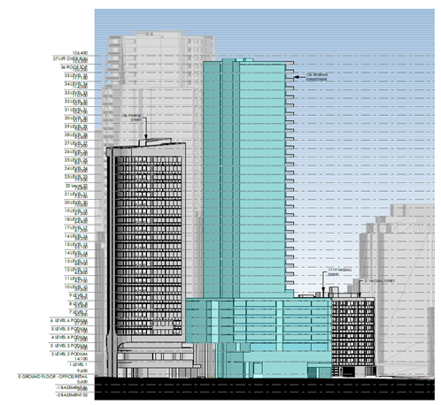
Figure
6: Proposed
Mixed Use Building (Source: Applicant’s Reference Design –
Residential)
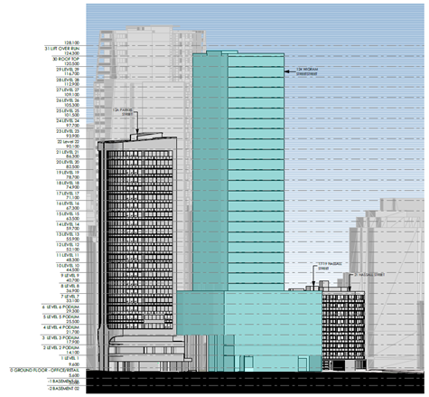
Figure
7: Proposed
Commercial Building (Source: Applicant’s Reference Design –
Commercial)
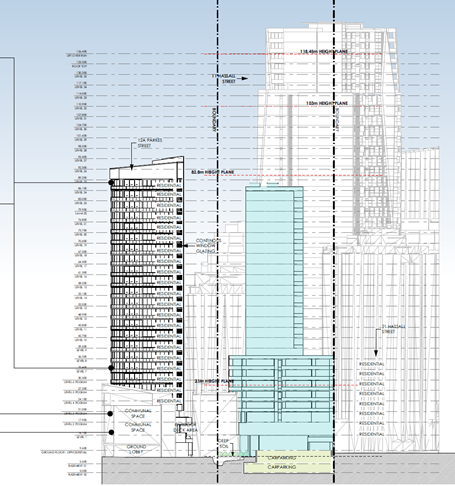
Figure 8: Building Achieved under Existing Height
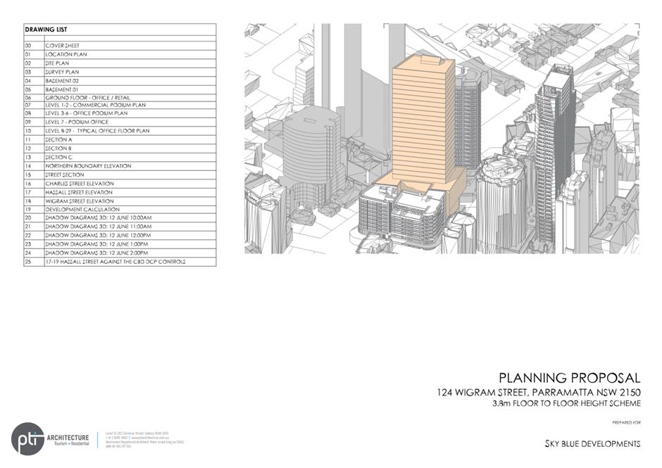
Controls (Source: PTI Architecture on behalf of applicant)
21. The Planning Proposal is accompanied by the following supporting
documentation submitted by the applicant:
a. Planning Proposal document prepared by Think Planners (see Attachment
1);
b. Reference Designs prepared by PTI Architecture for both a commercial
and a mixed use scheme (see Attachments 2 and 3 respectively);
c. Statement of Heritage Impact prepared by Cracknel and Lonergan (see Attachment
4); and
d. Letter from Mance Arraj Engineers in response to flooding concerns
raised by Council (see Attachment 5).
22. Table 2 below provides the floor areas and indicative dwelling
count outlined in the Reference Designs under the proposed height control
included in the Planning Proposal. The actual quantum of development provided
will be subject to a design excellence competition and assessment at the DA
stage.
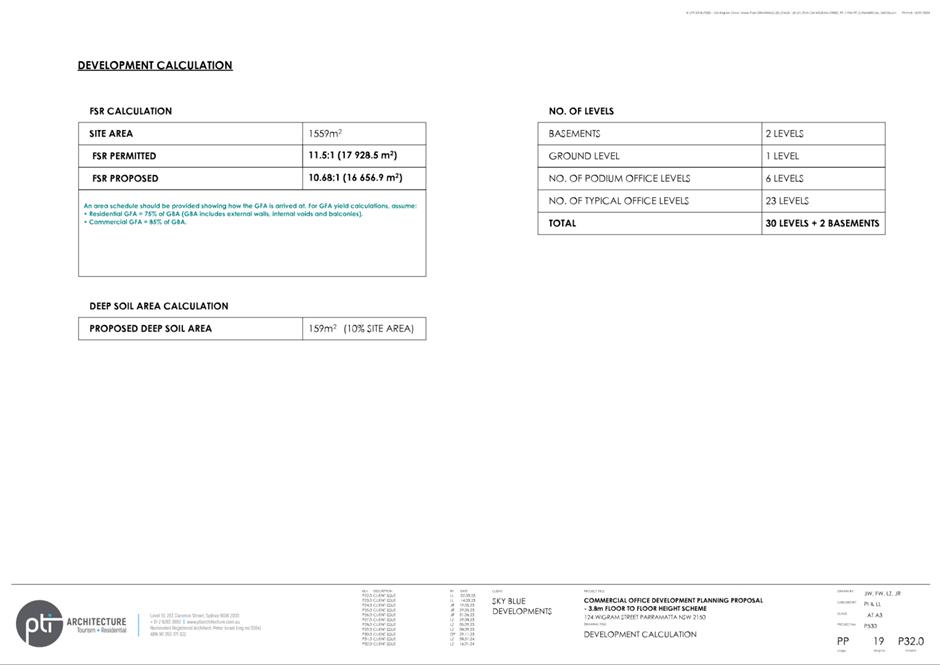
Table 2: Floor Area and Dwelling Count Comparison
Between Schemes
|
Scheme
|
Floor Area
|
Mix
|
FSR
|
|
Planning Proposal Reference Design -
Mixed Use Scheme
|
17,243.5sqm*
|
163 dwellings
1,556 sqm commercial
|
11.06:1**
|
|
Planning Proposal Reference Design -
Commercial Scheme
|
16,656.9sqm*
|
16,656.9 sqm commercial
|
10.68:1**
|
*Subject
to a design excellence competition and assessment at DA stage
**Subject to
compliance with isolated site requirements and assessment at DA stage
PLANNING PROPOSAL
ASSESSMENT
23. The NSW
Government Local Environmental Plan Making Guideline 2022 provides that for a Planning Proposal to proceed through Gateway determination, the
Minister (or their delegate) must be satisfied that the Proposal has strategic
and site-specific merit and that identified potential impacts can be readily
addressed during the subsequent plan making stages.
24. More
recently, the Minister for Planning has written to all councils and planning
panels asking them to ‘prioritise the delivery of housing when
assessing development applications and rezoning schemes, so that the entire
planning system is geared to addressing the housing shortfall’. The
Minister further asks that ‘...council teams prioritise the
opportunity to deliver homes as part of merit considerations where, on balance,
dwelling numbers may warrant a scale or built form that is different to or
greater than the outcome originally anticipated’.
25. The Minister
has further advised that updated region and cities plans are being prepared by
the Greater Cities Commission, and that in the meantime a strategic merit
assessment should be applied to Planning Proposals which will be used to
confirm if the Proposal can satisfy relevant regional, district, and local
strategies.
26. The
following sections detail Council Officer assessment of the Planning Proposal
based on strategic merit and site-specific planning issues.
Strategic Merit
27. Council Officers agree that the
Planning Proposal is aligned with key state policies including the Greater
Sydney Region Plan and the Central City District Plan; and key local policies
including the Local Strategic Planning Statement, Local Housing Strategy and
Parramatta CBD Planning Strategy. This alignment is discussed
below.
28. The Planning Proposal detailed in Attachment
1 provides a full assessment of the Proposal’s consistency against
relevant State Planning Policies and Ministerial Directions under Clause 9.1 of the Environmental Planning and Assessment Act
1979. Ministerial Direction 4.1
Flooding is of specific relevance to the site and is discussed below.
Greater
Sydney Region Plan and Central City District Plan
29. The Greater Sydney Region Plan:
A Metropolis of Three Cities aims to create a city sustained by a well-developed
infrastructure. Under Direction 1-Infrastructure Collaboration: A city
supported by infrastructure, Objectives 1, 2, 3, and 4 underscore the critical
role of adequate infrastructure in fostering resilient communities and aligning
with foreseen infrastructure needs of the forecasted growth. The Plan advocates
for an integrated planning approach, ensuring the strategic provision of
essential services, optimal infrastructure placement, and the creation of
employment opportunities.
30. The Planning Proposal is in
alignment with these objectives, capitalising on the subject site's strategic
proximity to the Parramatta CBD, facilitating convenient access to an array of
public transport options, including trains, buses, and ferries, with the added
benefit of an upcoming metro line and light rail service. Anticipating a
30-minute connection to the Sydney CBD via the prospective metro line, this
integration fits with the existing infrastructure. The proposed consolidation
of population around an existing metropolitan centre with numerous public
transit options is strategically optimised, effectively supporting the
forecasted growth, in accordance with Objective 4.
31. The Central
City District Plan (CCDP) identifies priorities for a Productive, Liveable and
Sustainable City. Planning Priorities C5 and C7 of the plan are relevant to
this Proposal which relate to the provision of “housing supply, choice
and affordability with access to jobs, services and public transport” and
“growing a stronger and more competitive Greater Parramatta”.
The mixed use scheme (Attachment 3) aims to increase housing supply in
Parramatta CBD, contributing to economic growth by generating jobs, services,
and entertainment options. Emphasising economic outcomes, the scheme also assists
by incorporating street level employment spaces, promoting a live-work
environment with a potential for individuals to reside and work in the same
place. Further, the scheme also helps address the current housing crisis, by
offering new housing in a highly liveable location.
32. The Greater
Parramatta to Olympic Peninsula (GPOP) is a substantial corridor that envisages
economic and housing growth within the Central River City and support
establishing Parramatta CBD as a central city in Greater Sydney covering an
area of about 6,000 hectares. Advocating the 30-minute approach adopted in the Greater Sydney Region
Plan, the mixed-use scheme of the Proposal draws on the transportation
connections within the corridor and would deliver dwellings within the
Parramatta CBD potentially accommodating a diverse range of residents.
Local
Strategies
33. The Local
Strategic Planning Statement (LSPS) and the Local Housing Strategy (LHS)
identify Parramatta CBD as a Metropolitan Centre, a growing district with an increasing
range of jobs and services. The LSPS and LHS anticipate an additional 7,180
dwellings and 34,500 jobs by 2036 in the precinct. The Planning Proposal would
contribute towards meeting these targets through the provision of additional
employment floorspace, and additional dwellings if the mixed use scheme is
pursued.
34. The
Parramatta Community Strategic Plan is a 25-year plan with strategic objectives
for the local government area. It seeks to formalise ideas that will shape and
transform the area by 2038 and provide a pathway to manage growth and
liveability, whilst providing additional jobs for residents. The Planning
Proposal is consistent with this, facilitating jobs through commercial
floorspace and an activated street frontage. The mixed use scheme is consistent
with the Plan as it would result in jobs and housing concentrated in an area
close to public transport infrastructure.
Site-Specific Merit
Urban Design
35. Reference designs supporting the Planning Proposal for both commercial
and mixed-use schemes (Attachments 2 and 3) have been reviewed by
Council officers. The review has focused on the impact on immediate and
surrounding areas and confirms that
a built form on the subject site can comfortably achieve the existing mapped
FSR and proposed total mapped building height of 103 metres (118.45 metres
including the design excellence bonus).
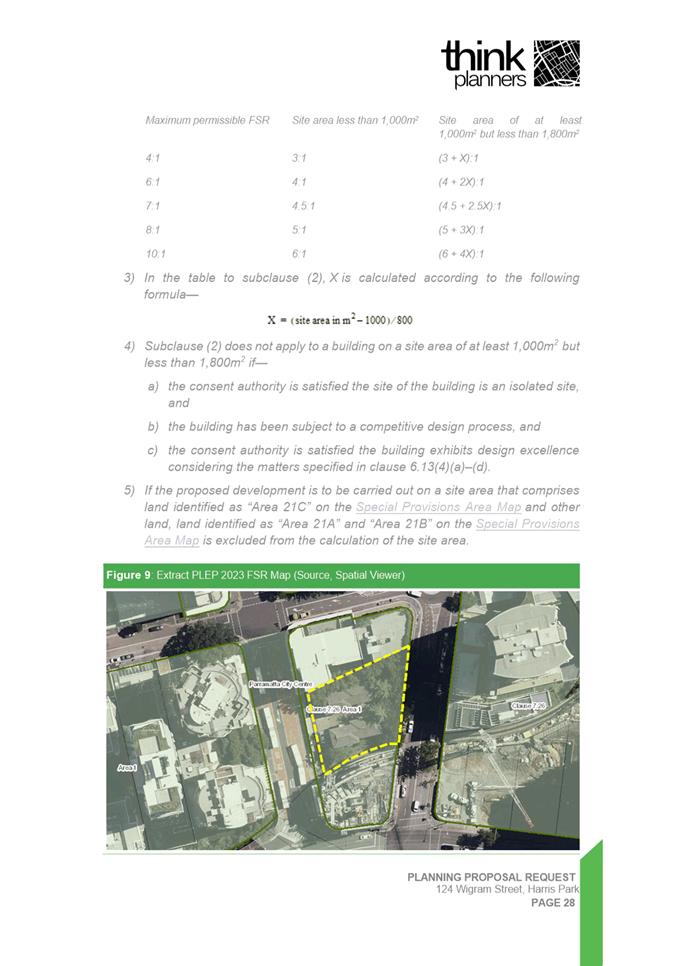
36. Clause 7.3 of the PLEP 2023 provides a FSR
sliding scale control for development in the Parramatta CBD including the site.
The intent of this clause is to ensure appropriate built form outcomes for
smaller sites. Clause 7.3(4) provides that the sliding scale does not apply to
sites that meet certain criteria and relates isolated sites. Any assessment of
a development application for the development of 124 Wigram Street would need
to consider the criteria when determining whether the site can be considered
isolated and exempt from the FSR sliding scale. It could be argued that the subject site may
meet the criteria for an isolated site due to the location of Clay Cliff Creek
on the southern boundary and the nature of development on the two sites
immediately to the north. In this regard, both 17-19 Hassall Street and 21
Hassall Street contain recently built residential apartment buildings of 7
storeys and 9 storeys respectively. Both are under strata title with multiple
owners. While this does not prohibit redevelopment of these sites it makes it
less likely that they will be redeveloped in the foreseeable future.
37. The solar
access impacts on the Harris Park West HCA were considered by Council Officers
as the primary basis for identifying the maximum acceptable height for the
site. The analysis modelled the likely shadows cast from both existing
buildings and likely future development permitted under the existing height
controls that currently apply to surrounding sites (See Attachment 6).
38. The maximum
height that could be achieved on the site while causing only minimal
overshadowing on the Harris Park West HCA was calculated at a total of 119
metres. This equates to a mapped height control of 103 metres which permits a
total height of 118.45 metres when including the 15 per cent Design Excellence
bonus. This height creates minimal overshadowing to the Harris Park West HCA
and the shadow length is consistent with shadows from taller towers to the
north.
39. To achieve
the proposed maximum height, a design excellence competition will need to be
undertaken. Design excellence competitions aim to enable the selection of the
highest quality architectural and urban design solution for a development site.
This will provide an opportunity to further improve on and refine one of the
built forms shown in the reference designs submitted to support the Planning
Proposal, prior to submission of a development application. The final built
form will also be subject to further assessment at the development application
stage.
40. Another key
consideration for the site and resulting urban design is flooding. As
discussed below, a local flooding study is required to give
better definition to the extent of high hazard and floodway flooding across the
site and its interaction with a new building footprint design that meets
Council’s criteria. This will help to inform any future design
competition and development application on the site.
Transport
41. The site is
considered suitable for high density commercial or mixed use development
including residential due to its accessibility to transport and employment
opportunities in the Parramatta CBD. The site is located not only within the
Parramatta CBD but also within 400m walking distance to Parramatta Train
Station. Due to its CBD location, the site is also highly accessible to
existing bus services, pedestrian pathways, and cycleways.
42. The site is
also within close proximity to Stage 1 of the Parramatta Light Rail, with a
proposed light rail stop to be located at the corner of Harris and Macquarie
Streets approximately 350 metres walking distance from the site. Stage 1
will connect Westmead to Carlingford via the Parramatta CBD and Camellia and is
expected to open in 2024. The light rail is planned to be serviced from 5am to
1am, 7 days a week with services approximately every 7.5 minutes from 7am to
7pm weekdays.
43. Sydney Metro
West is a proposed underground railway project that connects Westmead and the
Sydney CBD via Parramatta. The subject site is within 700m walking distance of
a new metro station to be located in the Parramatta City Centre.
44. The
proximity of the site to existing and future major transport infrastructure
makes the site an ideal location for higher density residential and commercial
development. Development of the site is also likely to contribute to mode shift
away from private vehicles and towards public and active transport.
Traffic, Parking and Access
45. Traffic impacts
for the current floor area permitted on the site were assessed as part of the
Parramatta CBD Planning Proposal. As no change to the floor space ratio is
proposed, traffic impacts were not required to be further assessed as part of
this Planning Proposal. Further assessment of traffic impacts will occur at the
development application stage.
46. Parking and
vehicular access will be required to comply with the provisions of the PLEP
2023 and Council’s Development Control Plan for the CBD in any future development
application. Vehicular access will also be considered in any design excellence
competition.
Heritage
47. A Statement
of Heritage Impact (SoHI) supports the Planning Proposal and is included at Attachment
4. The statement details that there are no heritage items located on the
site. However, there are heritage listed items within proximity of the site as
demonstrated in Figures 4 and 5 above. The site is also within walking
distance of a cluster of heritage items and the Harris Park West and the
Experiment Farm HCAs to the south.
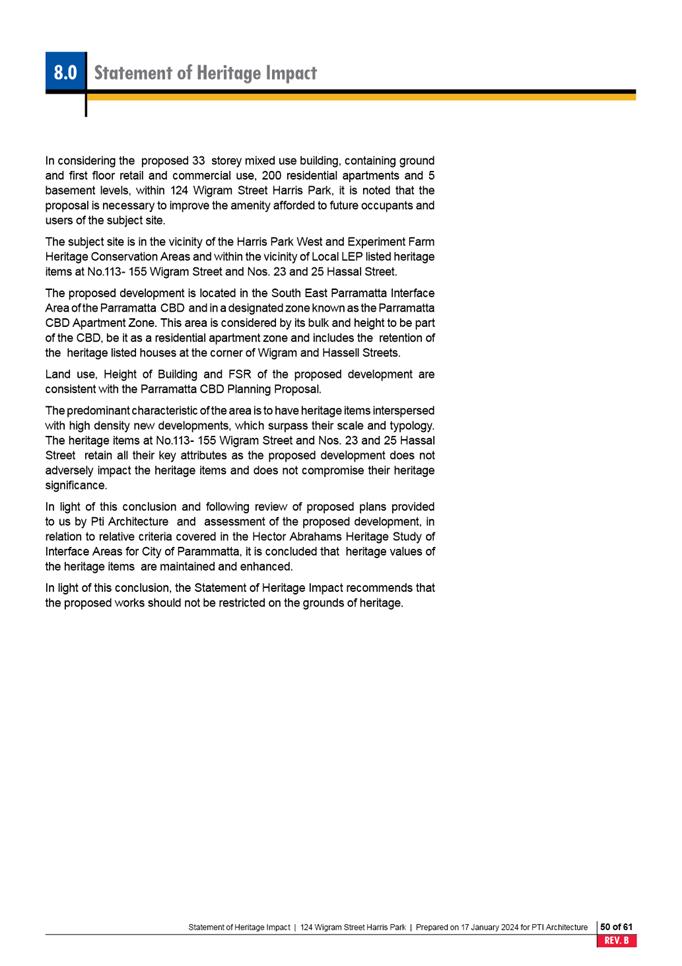
48. The SoHI concludes that the Proposal will not adversely impact the
heritage items or the HCAs, does not compromise their heritage significance and
that the proposed works should not be restricted on the grounds of heritage.
This position is supported by Council’s Senior
Heritage Specialist.
49. The previous
proposal was discussed at the Heritage Advisory Committee meeting on 27
November 2019. The Committee at that time expressed concern at the impact of
the Proposal on heritage items opposite the site in Wigram Street.
50. The current Proposal was considered by Council’s Heritage
Advisory Committee on 8 February 2024. Some members of the Committee considered
the additional height would not impact the significance of the heritage
items. Other Committee members did not support the principle of variations
to the newly finalised Parramatta CBD Planning Proposal more broadly. Council
Officers at the meeting noted that the subject Planning Proposal was lodged
with Council in 2019 well in advance of the finalisation of the Parramatta CBD
Planning Proposal and is seeking to increase height in order to better align
with the floor space ratio established by the Parramatta CBD Planning Proposal.
Infrastructure, Social and Economic Impacts
51. The delivery
of either scheme within the Parramatta CBD will achieve a positive social
outcome being well serviced by existing infrastructure. People will be able
access necessary transport, education services, open space, health services,
community services, employment, and recreation facilities.
52. Council’s Community Infrastructure Strategy supports the City
of Parramatta’s growth by identifying priorities for future community
infrastructure and informing planning, funding, delivering, and negotiating for
community infrastructure. Council also has a Development Contributions Plan for
identified infrastructure for the CBD. Both will be considered as part of any
future development application for the site and required contributions towards
additional infrastructure will become conditions of any development consent.
53. As discussed
above in the strategic merit section, the Proposal will also facilitate
development that will assist in the emergence of Parramatta as Sydney’s
Central City which will in turn contribute to continued economic growth.
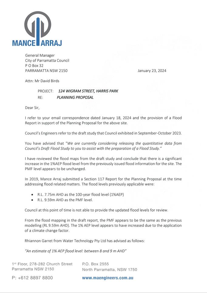
Flooding
54. The Planning
Proposal and associated reference design as originally lodged, addressed the
Upper Parramatta River Flood Study 2005. Since lodgment, Council has prepared
and exhibited the draft Parramatta River Flood Study 2023. While this draft
Study has yet to be endorsed by Council, it is prudent for Council to assess
the Planning Proposal against this updated Study due to the sensitive nature of
the site which is at risk of severe flooding from Clay Cliff Creek.
55. The Planning
Proposal is also required to address Local Planning Direction 4.1 Flooding
issued by the Minister for Planning under section 9.1(2) of the Environmental
Planning and Assessment Act 1979. Planning Proposals are required to
demonstrate that they are consistent with the Direction and any inconsistency
is required to be justified.
56. In addition,
on 10 November 2023, the NSW Government Flood Risk Management Policy,
accompanying Manual and Guidelines were gazetted, replacing the previous
Floodplain Development Manual. The new Manual is reflected in Council’s
DCP 2023 and the Guidelines place emphasis on management and reduction of risk
and hazard and avoiding the obstruction of floodways and overland flow paths
when planning development.
57. In this
regard, Council requires that any high hazard/floodway area not be obstructed
at ground level and requires a 4 metre clearance above ground to any
overhanging structure with an extent of overhang horizontally of less than 4
metres. This is in addition to the 6 metre setback to the centreline of
the Clay Cliff Creek channel with no overhang above it. The reference
design submitted by the applicant demonstrates compliance with these
requirements, however, this is in relation to the flood levels identified under
the Upper Parramatta River Flood Study 2005.
58. Council
Officers have requested the applicant submit a local Flood Study and revised
reference design which reflects the draft Parramatta River Flood Study 2023 and
is consistent with the NSW Flood Risk Management Manual
and Guidelines and the Parramatta DCP 2023.
59. In response, the applicant has submitted that the Planning Proposal
is seeking an increase in building height which has no bearing with the
flooding levels on site. The flooding design requirements for the ground floor
will not change because of the subject Planning Proposal and in any case, are
subject to consideration when a development application is submitted.
60. To support this position, the applicant has submitted a letter from
Mance Arraj Engineers (see Attachment 5) which provides an opinion
summarised as follows:
a. While there is a
significant increase in the 1% AEP flood level from the previous flood
information, the Probable Maximum Flood (PMF) level remains unchanged. As
such, the original report submitted to address the Local Planning Direction 4.1
Flooding (referred to by applicant as a Section 117 Direction which was the
equivalent reference under previous legislation) is adequate to progress the
Planning Proposal given that the proposal provides flood protection to the PMF
level identified in the draft Parramatta River Flood Study 2023.
b. Flood modelling
will be required at development application stage which will determine the
alignment of the basement wall. Any such modelling is not expected to
identify a significant change in flows at this location as the culverts at
Charles Street and Wigram Street are control structures and flows are diverted
by these structures.
61. In response,
Council’s Senior Catchment Engineer has noted that from the information
available in the draft Parramatta River Flood Study 2023, it is clear
that there is a much larger area of the site subject to high hazard
conditions and the presence of the floodway/main and lateral conveyances
compared to that described in the 2005 study. Without a local flooding study,
there is much uncertainty regarding the design response required on this site.
As such, Council’s Senior
Catchment Engineer is of a view that it is not
considered appropriate to defer consideration of flooding matters until the
Design Excellence and development application stage.
62. Since the Planning Proposal was lodged well in advance of the public
exhibition of the draft Parramatta
River Flood Study 2023, it is considered unreasonable to delay progressing the
matter pending the preparation of a local flood study. Instead it is
recommended that in seeking a Gateway determination, Council note the status of
flooding information available for the site and request that the DPHI considers
including a Gateway condition which requires the preparation of a local flood
study which addresses the concerns raised by Council in this report in the
context of Local Planning Direction 4.1 Flooding, the draft Parramatta River
Flood Study 2023 and the Flood Risk Management Manual
2023.
63. The Gateway condition should
also include a requirement that the reference design be updated to address
these criteria and the flood levels associated with the draft Parramatta River
Flood Study 2023.
Environment
64. The site
does not contain any habitat and therefore there is no likelihood that critical
habitat or threatened species, populations or ecological communities, or their
habitats could be adversely affected because of the Planning Proposal.
65. Other
environmental impacts, including sustainability, will be addressed as part of
any future development proposal, including a design excellence competition.
PLAN MAKING DELEGATIONS
66. Should
Council resolve to endorse the Planning Proposal to proceed, it is recommended
that Council request that it exercise its plan-making delegations. This means
that once the Planning Proposal has been to Gateway, undergone public exhibition
and been adopted by Council, Council officers will deal directly with the
Parliamentary Counsel Office on the legal drafting and mapping of the
amendment. The LEP amendment is then signed by the CEO before being notified on
the NSW Legislation website.
FINANCIAL IMPLICATIONS FOR COUNCIL
67. Should
Council resolve to proceed with the Planning Proposal, the costs incurred in
conducting the public exhibition will be covered by the fees associated with
the submission of the Planning Proposal.
CONCLUSION AND NEXT STEPS
68. This
report recommends that the Planning Proposal for 124 Wigram Street, Harris Park
be submitted to the DPHI for Gateway determination to amend the PLEP
2023 Height of Building Map from 72 metres to a maximum building height of 103
metres (118.45 metres when including the 15% Design Excellence bonus).
69. It is
recommended that in seeking a Gateway determination, Council note the status of
flooding information available for the site and request that the DPHI consider
including a Gateway condition which requires the Planning Proposal to address
Local Planning Direction 4.1 Flooding in the context of the draft Parramatta
River Flood Study 2023 and the Flood Risk Management
Manual 2023. The Gateway
condition should also include a requirement that the reference design be updated
to address these criteria and the flood levels associated with the draft
Parramatta River Flood Study 2023.
70. Following
Local Planning Panel consideration of the Proposal, the Planning Proposal will
be considered by Council. Should the Proposal be supported by Council it will
be forwarded to the DPHI with a request for a Gateway Determination.
Felicity Roberts
Project Officer-Land Use
Naomi L'Oste-Brown
Team Leader Land Use Planning
David Birds
Group Manager, Major Projects and Precincts
Jennifer Concato
Executive Director City Planning and
Design
Attachments:
|
1⇩ 
|
Applicant's Planning Proposal
|
67 Pages
|
|
|
2⇩ 
|
Reference Design - Commercial Scheme
|
26 Pages
|
|
|
3⇩
|
Reference Design - Mixed Use Scheme
|
27 Pages
|
|
|
4⇩
|
Statement of Heritage Impact
|
65 Pages
|
|
|
5⇩
|
Letter from Mance Arraj Engineers
regarding flooding
|
2 Pages
|
|
|
6⇩
|
Shadow analysis
|
1 Page
|
|
REFERENCE MATERIAL