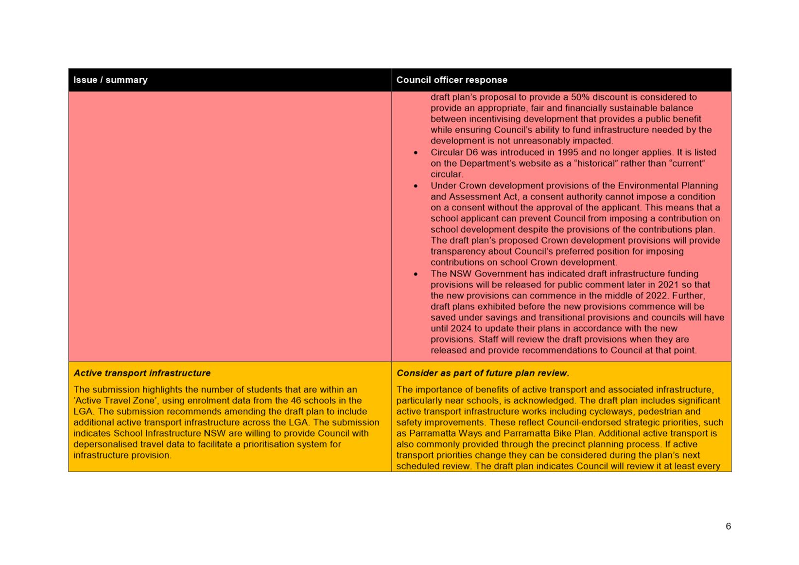
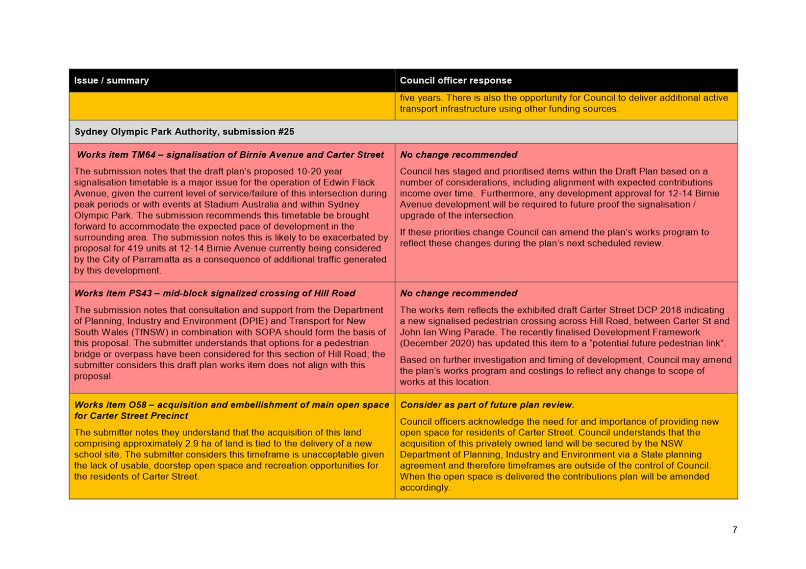
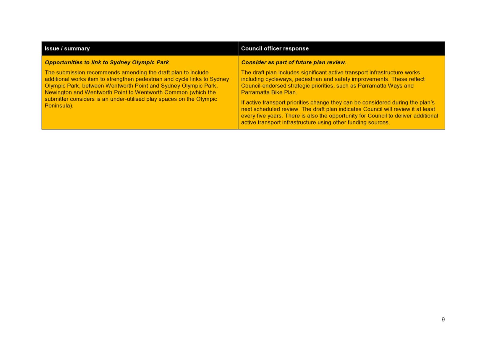
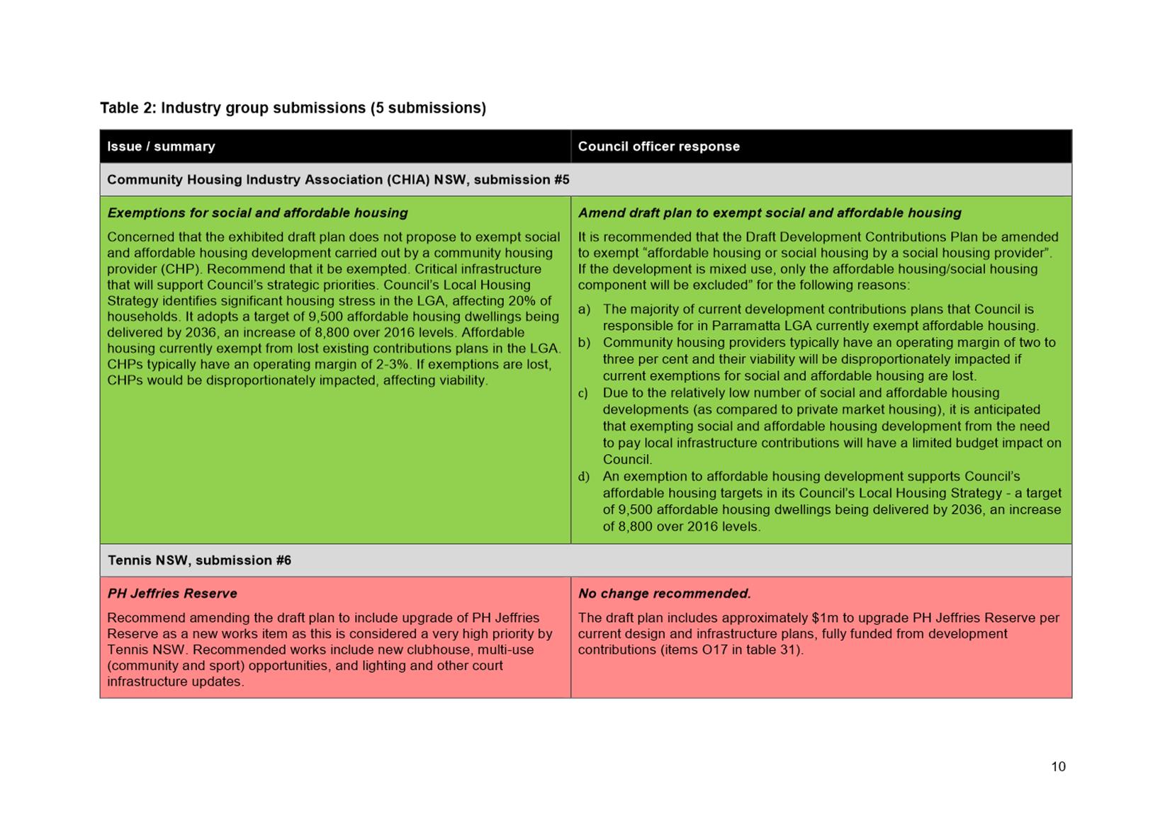
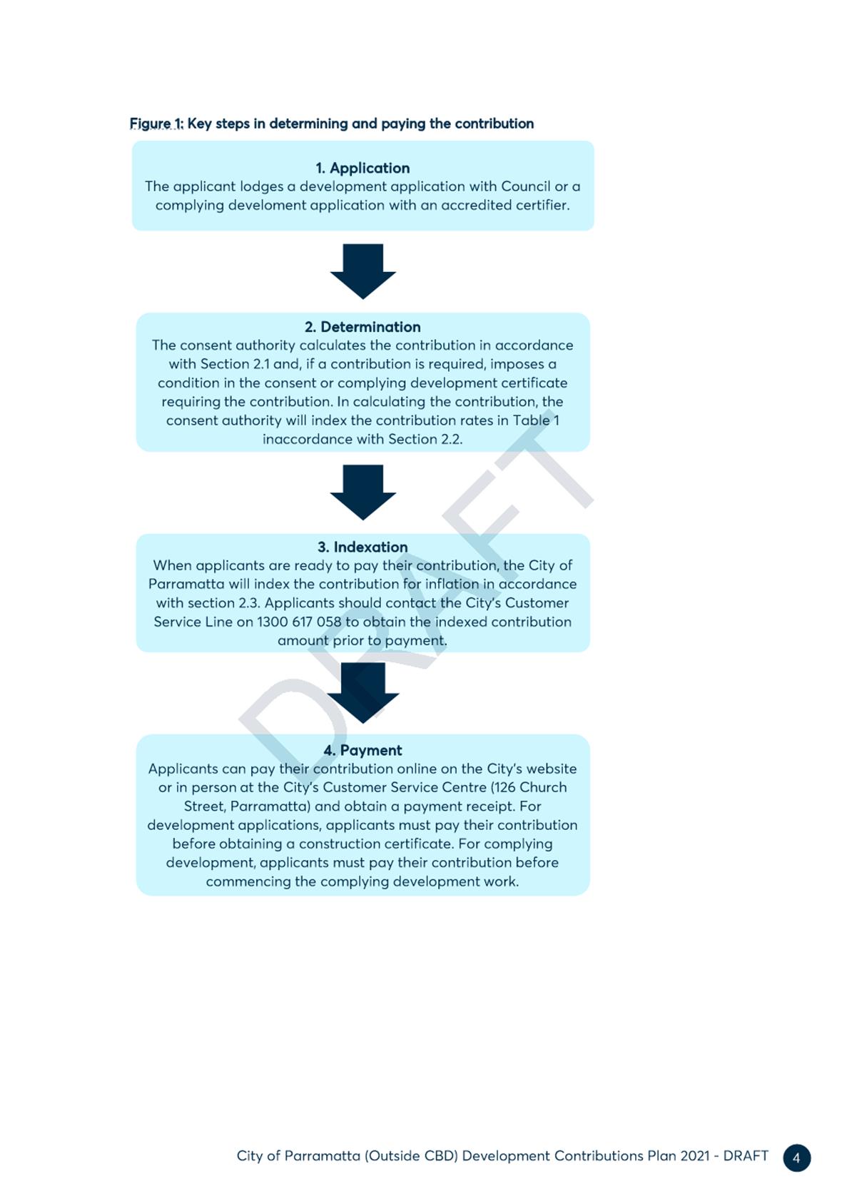
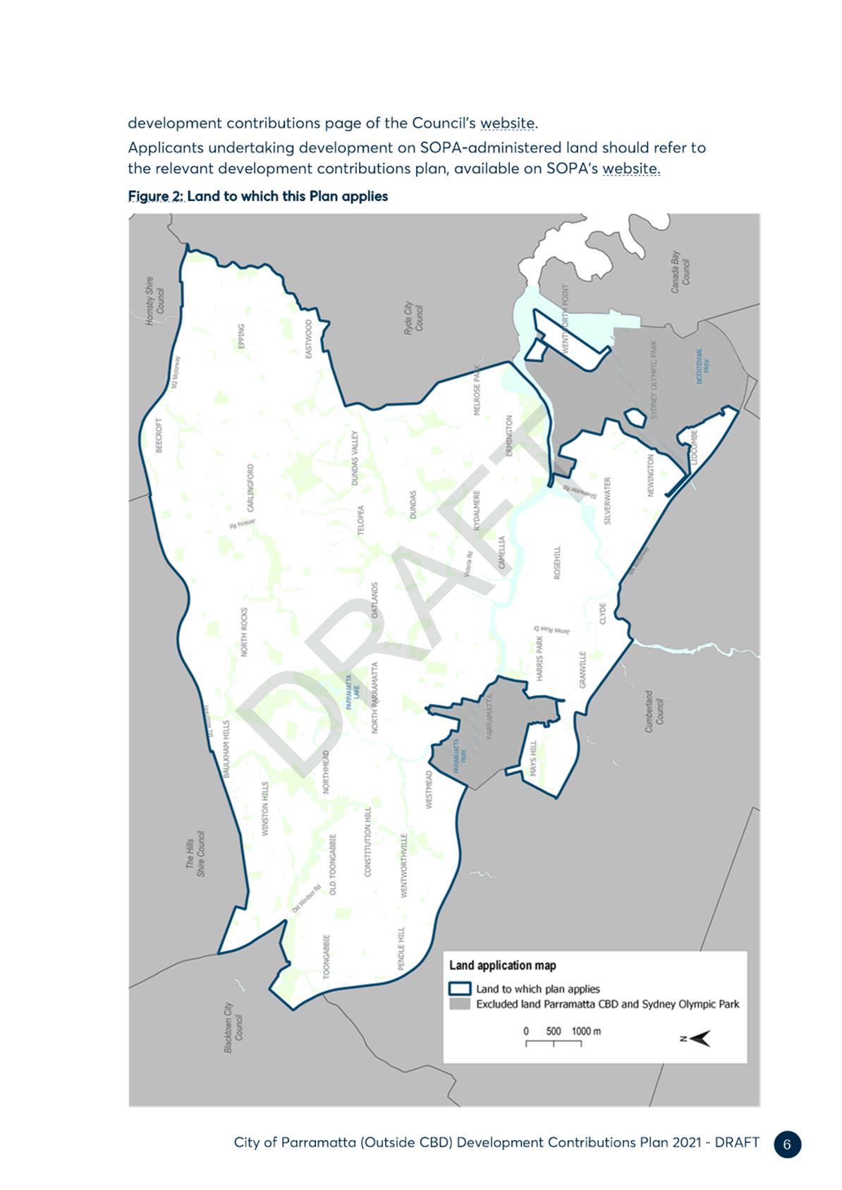
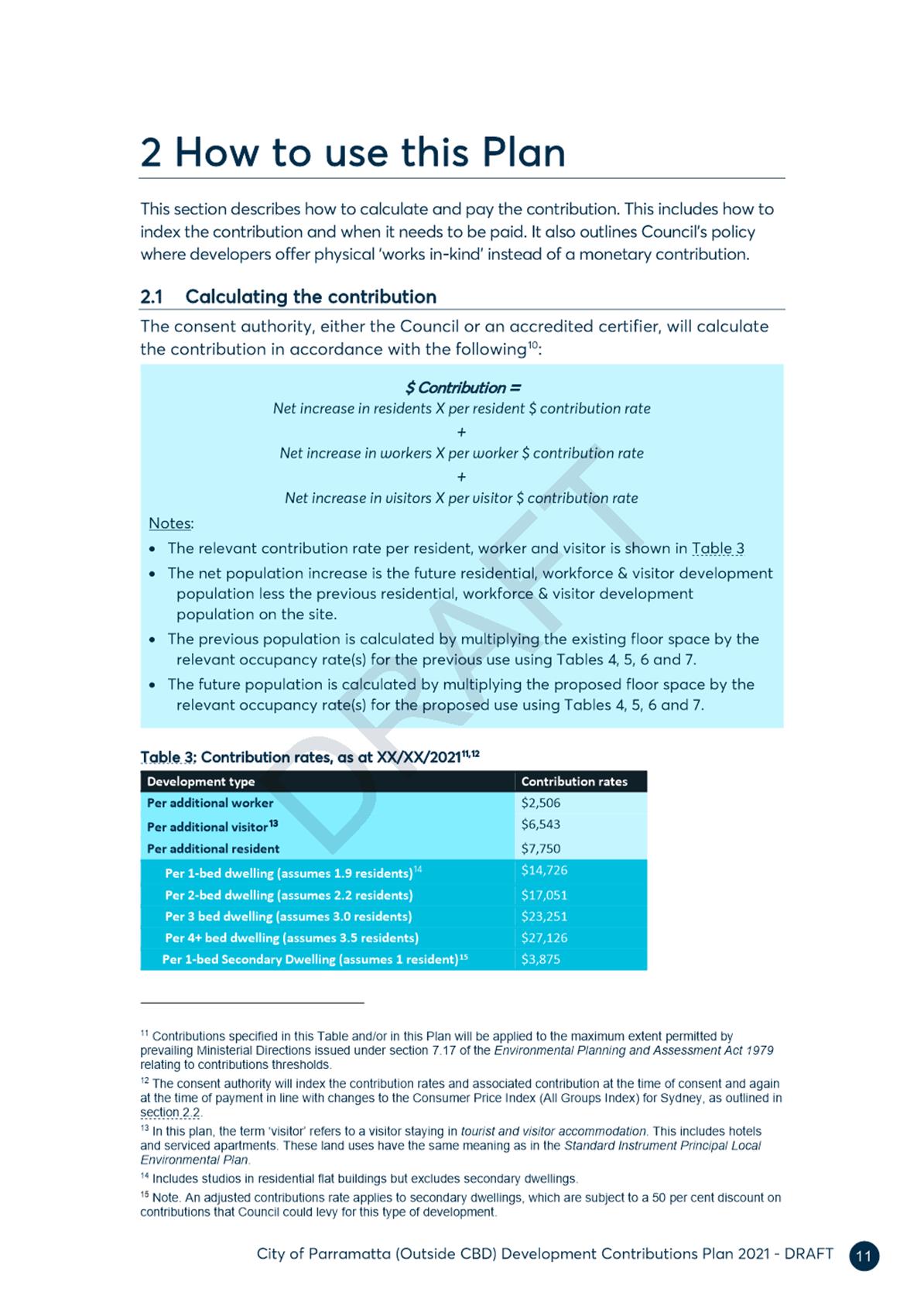
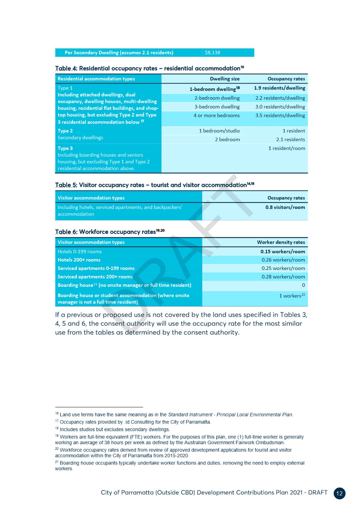
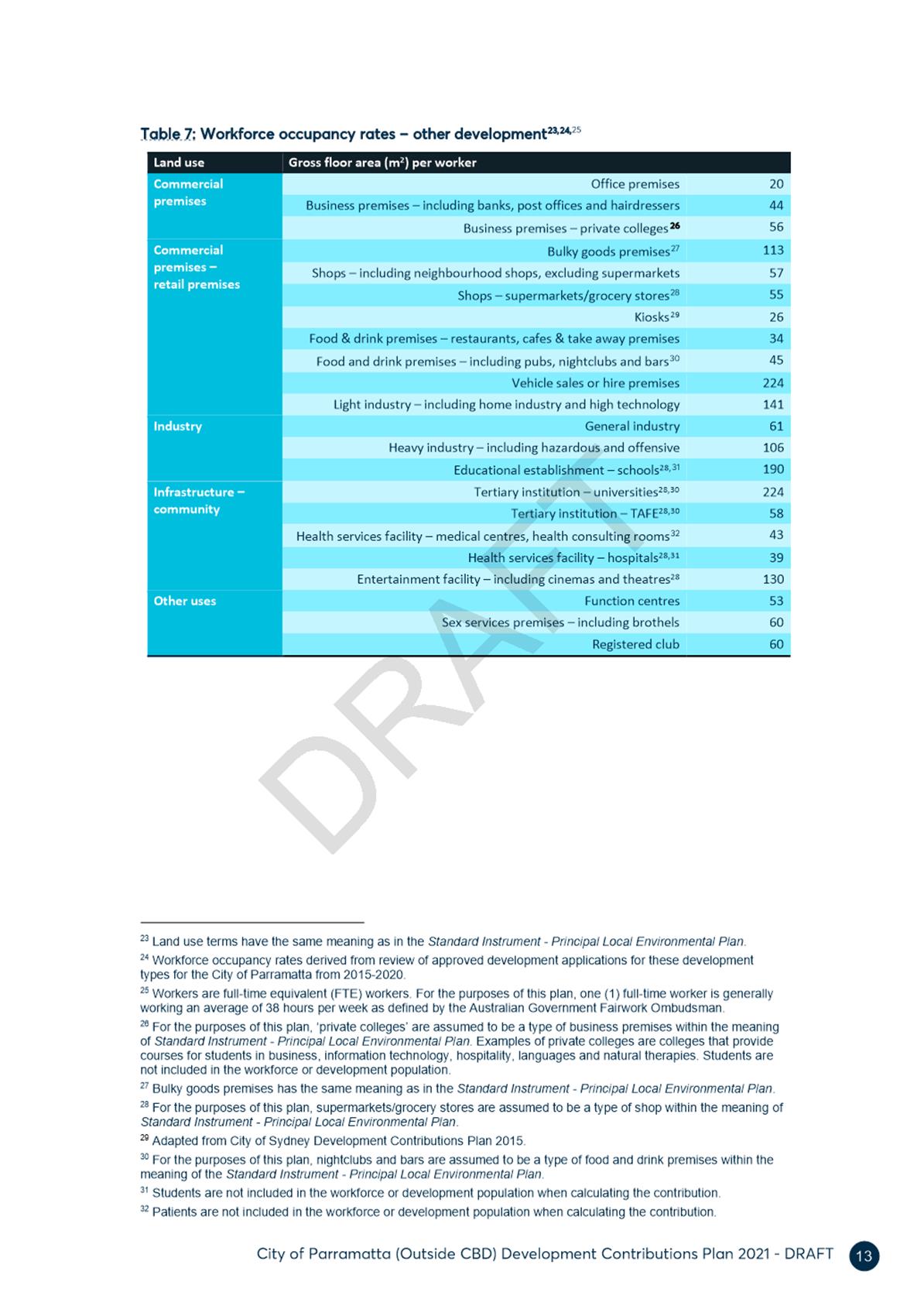
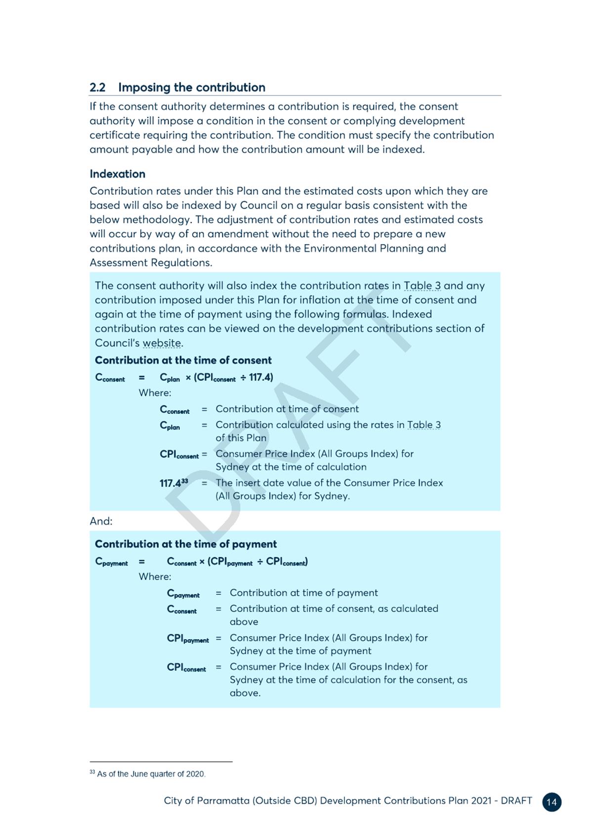
|
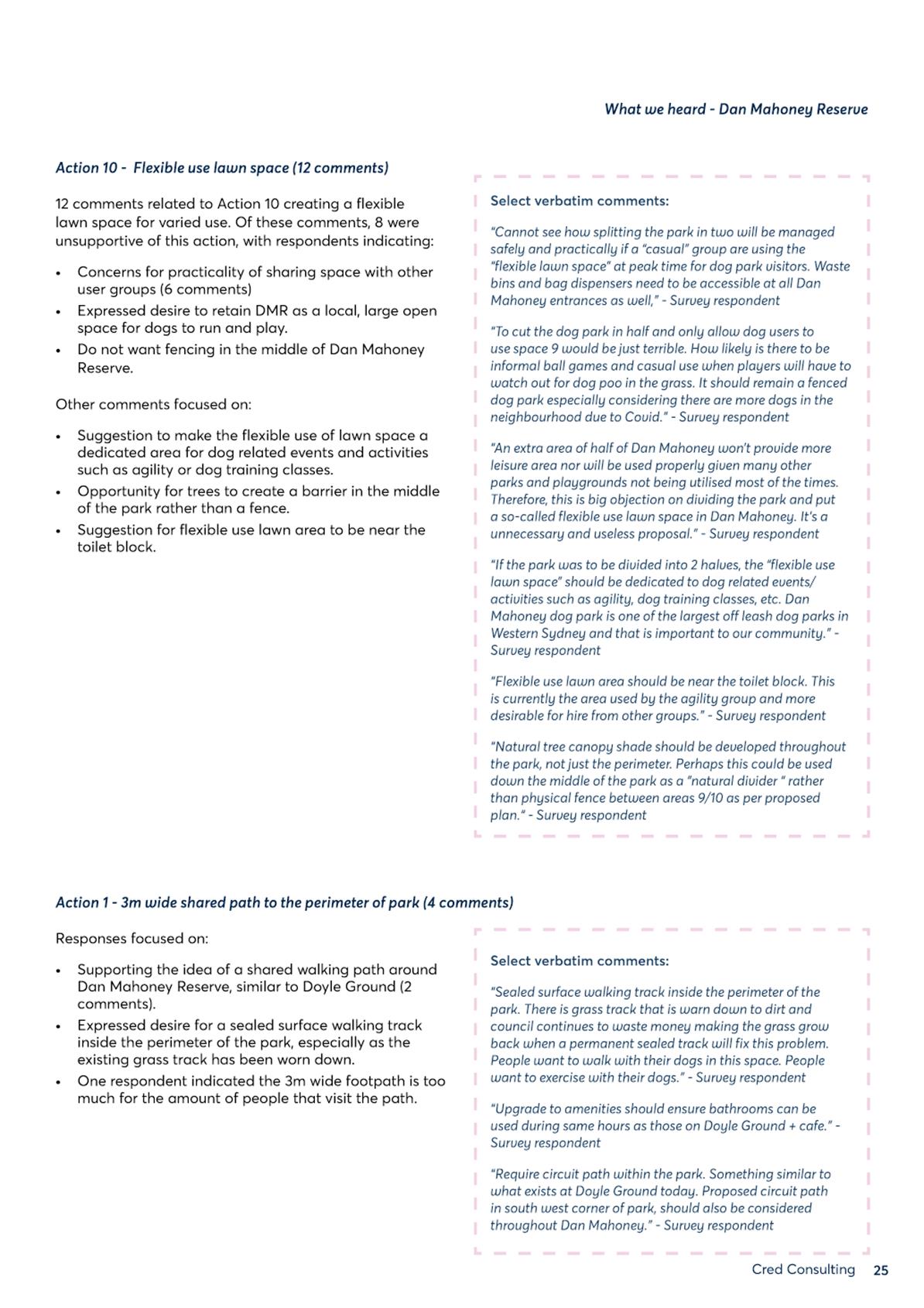
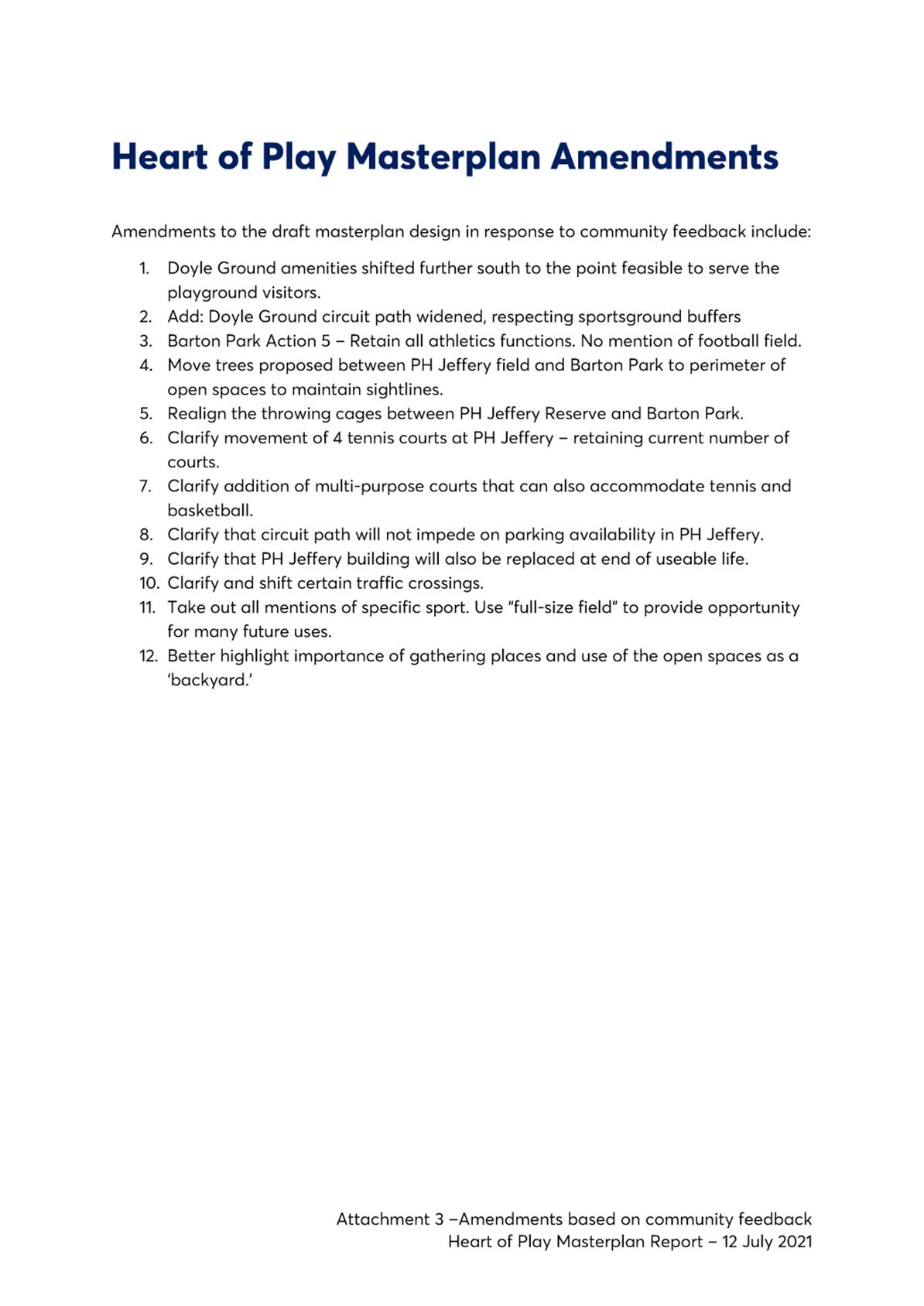
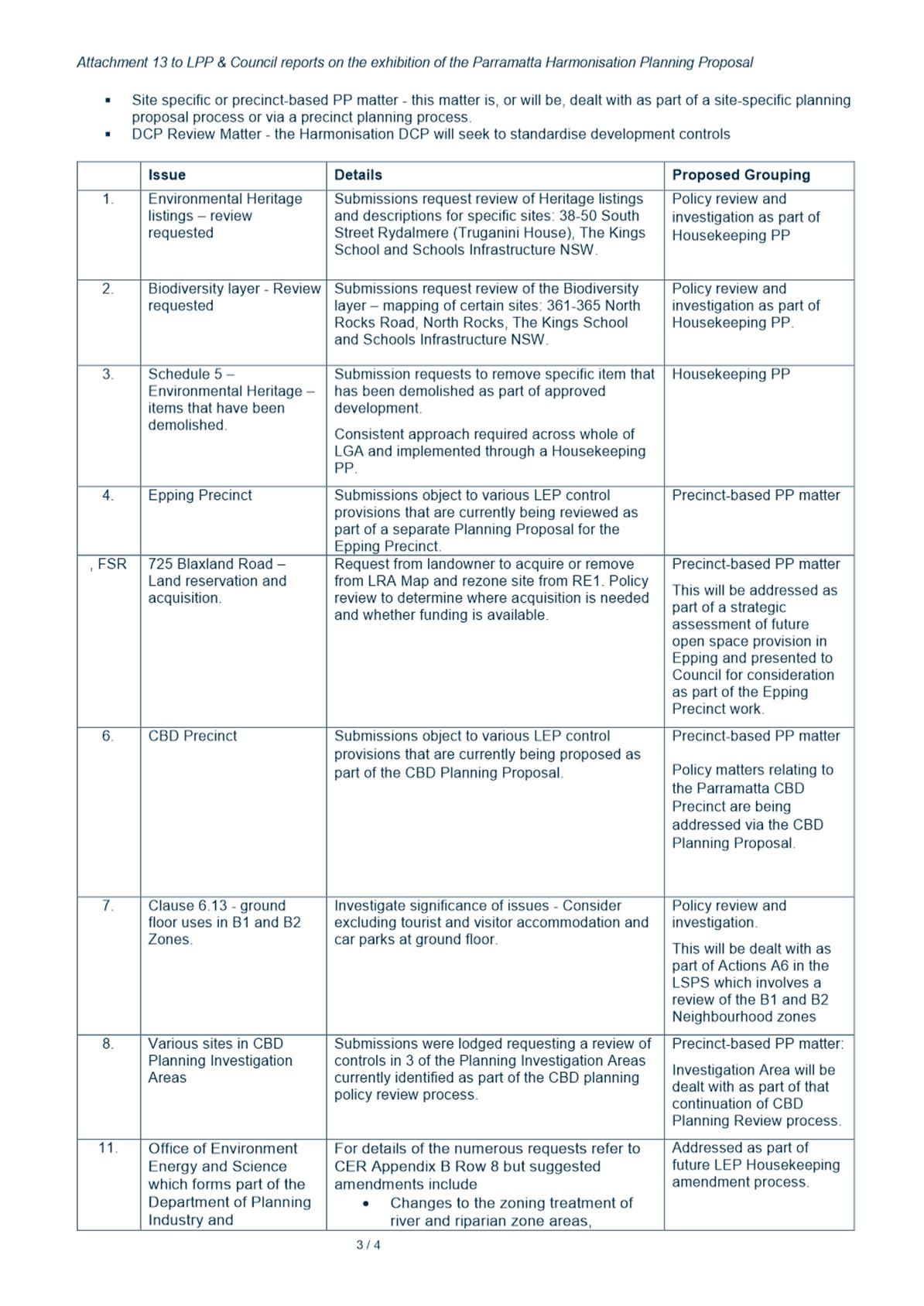
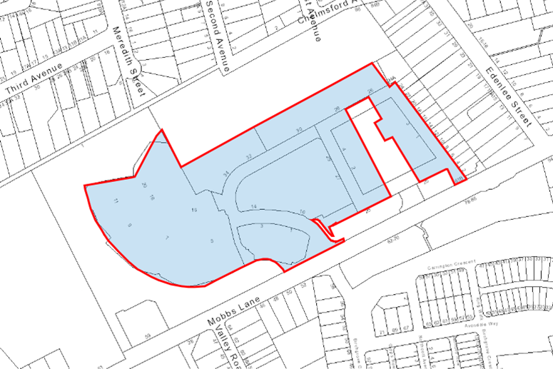
Item 13.1 - Attachment 1 |
Development Application Variations under SEPP 1 - 17 May - 16 June 2021 |
NOTICE OF Council MEETING
PUBLIC AGENDA
An Ordinary Meeting of City of Parramatta Council will be held in the Don Moore Community Centre, Corner of North Rocks Road and Farnell Avenue, North Rocks on Monday, 12 July 2021 at 6.30pm.
Note: Any change to the location of the Council Meeting due to any extension of the NSW Government’s stay at home orders or increase in restrictions will be communicated when known.
Brett Newman
CHIEF EXECUTIVE OFFICER
THIS PAGE IS LEFT INTENTIONALLY BLANK
COUNCIL CHAMBERS
|
Governance Manager |
Lord Mayor |
Chief Executive Officer |
|
|||||||
|
|
||||||||||
|
|
|
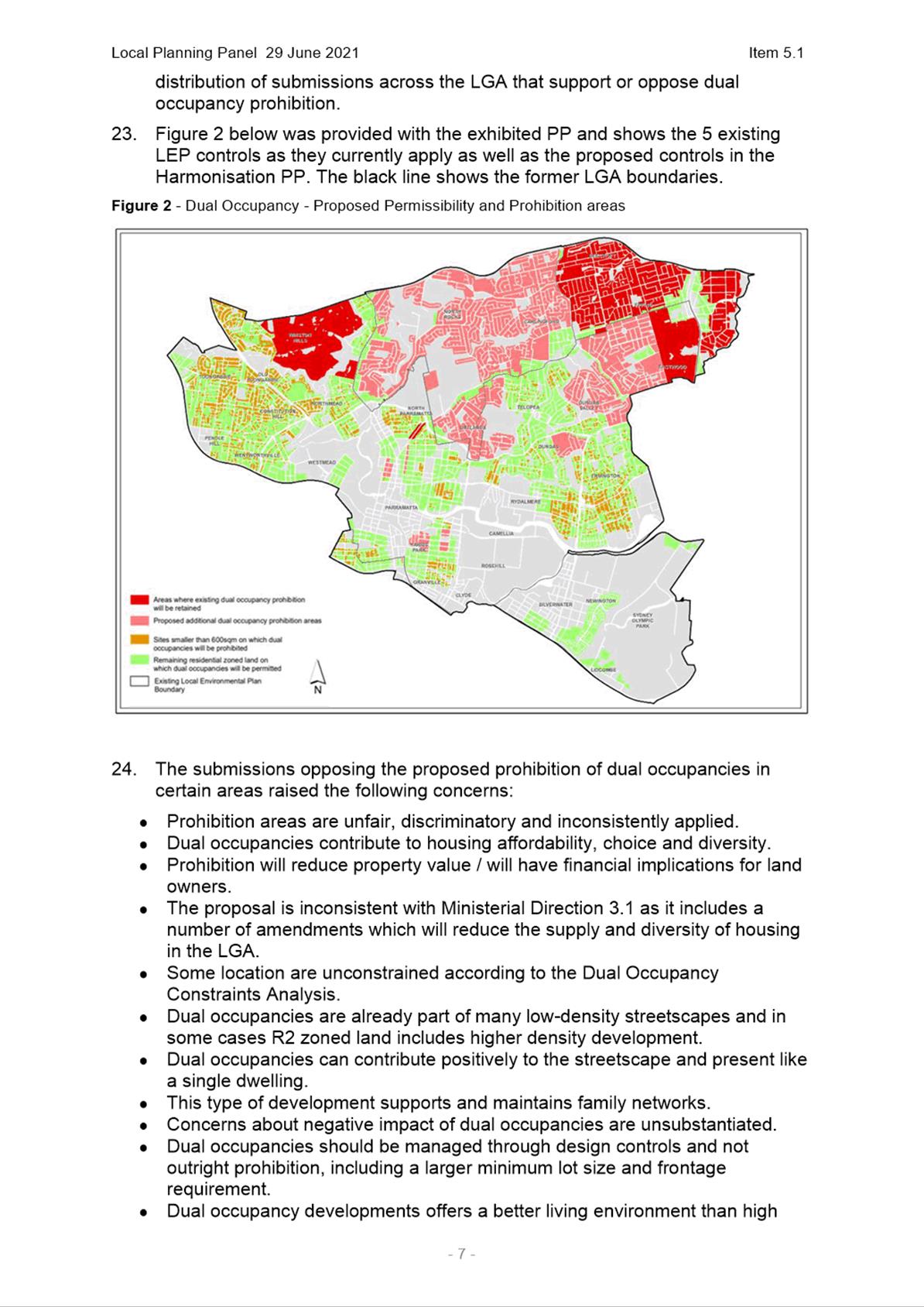
Minute Clerk |
|
|
|
|
||||
|
Clr Phil Bradley |
|
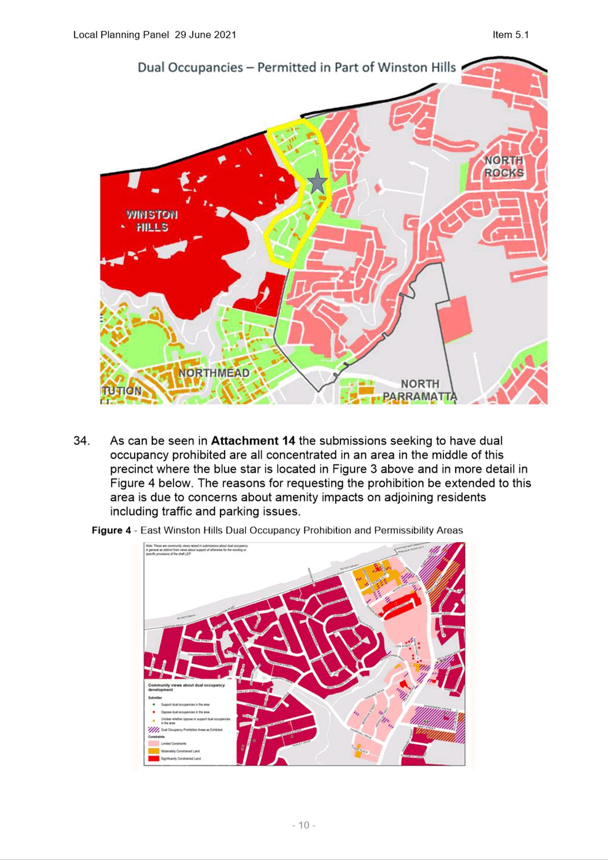
Clr Lorraine Wearne
|
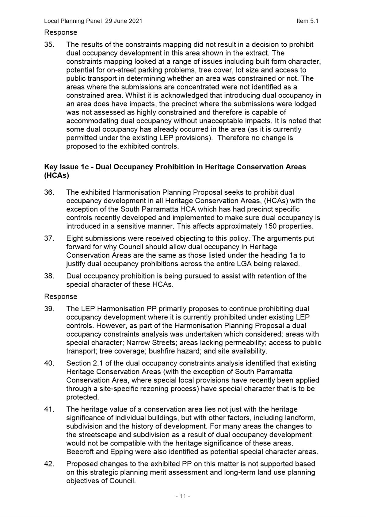
|
Sound |
||||||
|
Clr Sameer Pandey |
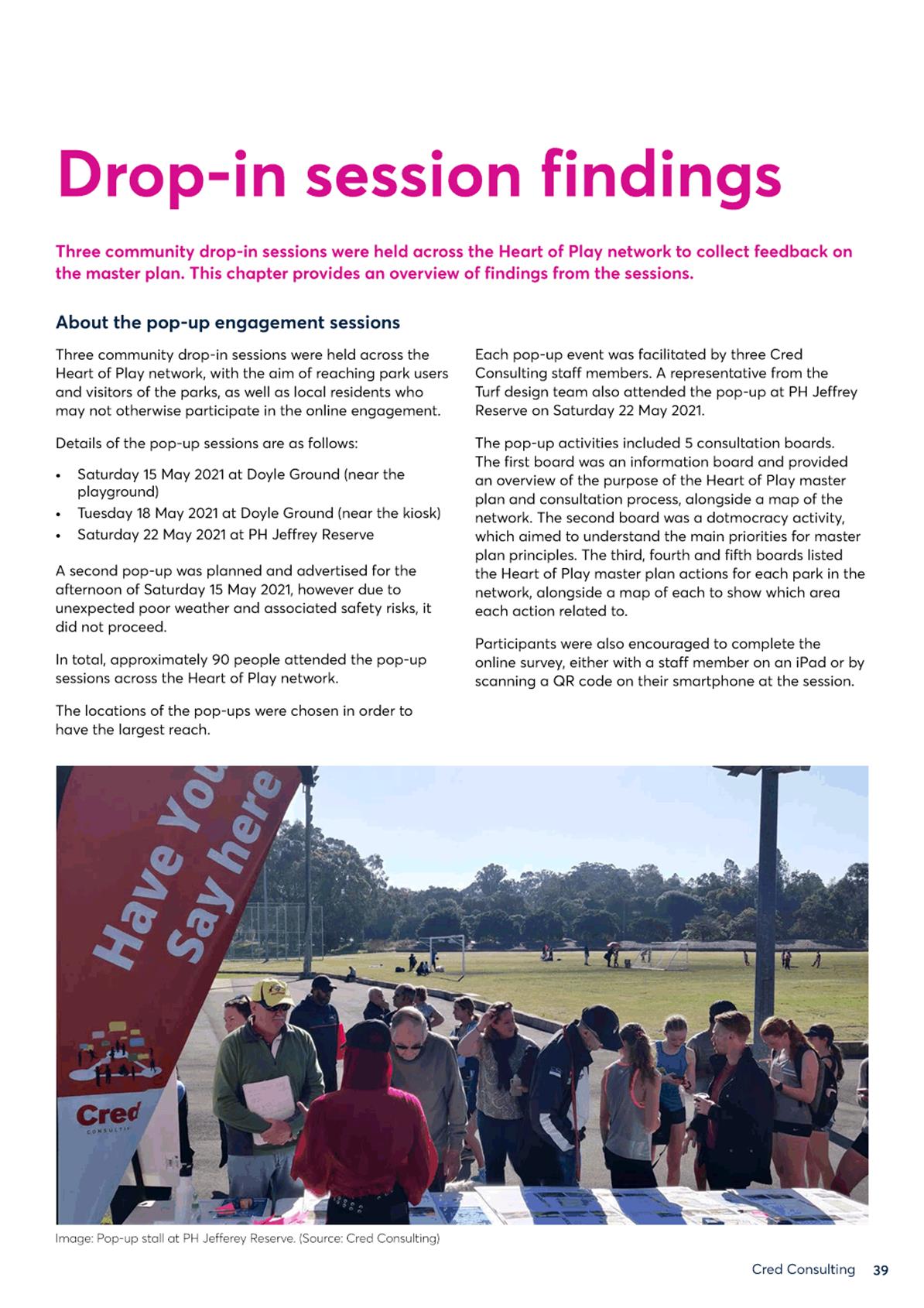
Clr Andrew Wilson
|
|
|
|||||||
|
|
Clr Andrew Jefferies
|
|
|
|||||||
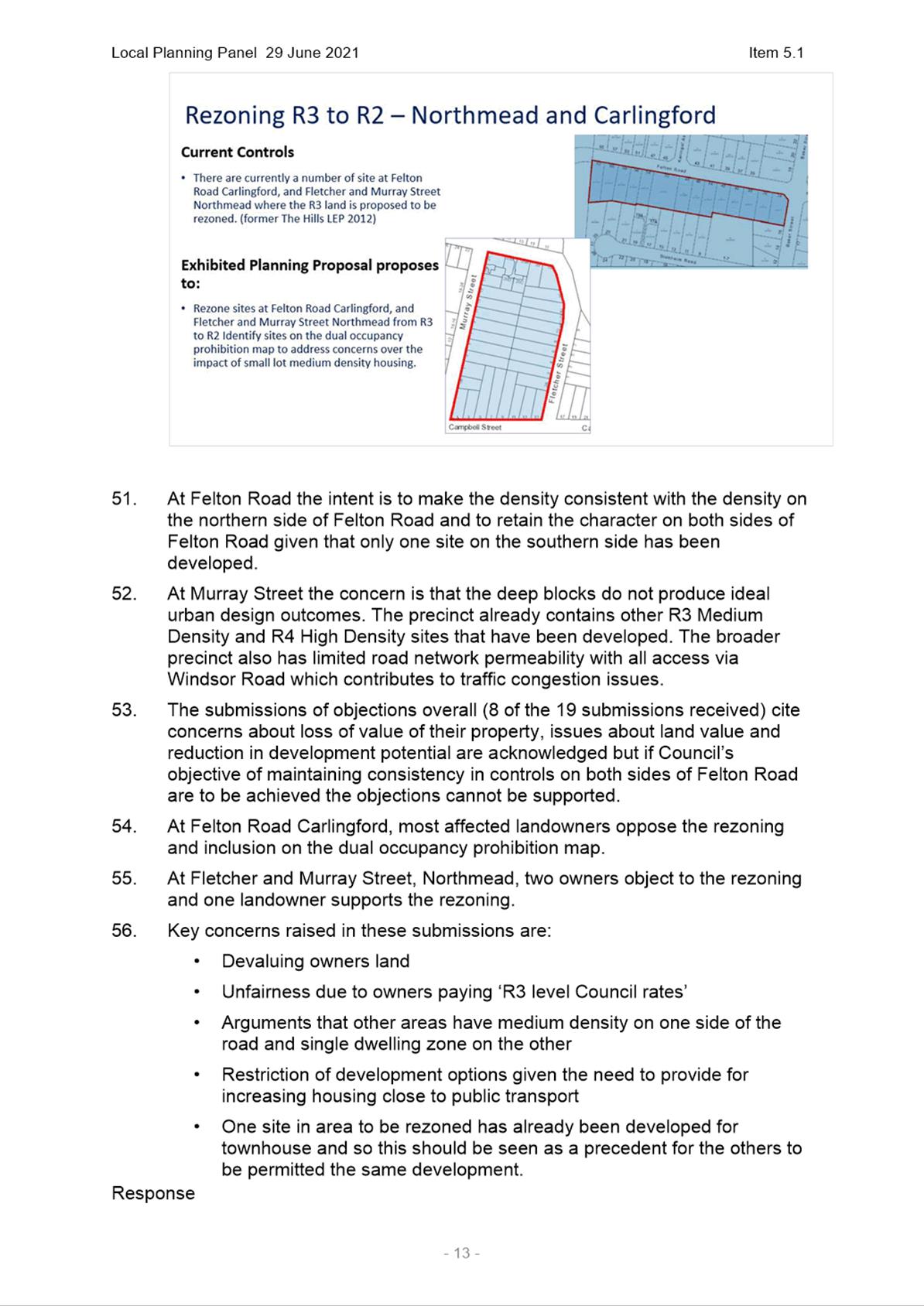
|
Clr Dr Patricia Prociv |
Clr Bill Tyrrell
|
|
IT |
|||||||
|
Clr Pierre Esber |
Clr Benjamin Barrak
|
|
|
|||||||
|
Clr Donna Davis |
Clr Martin Zaiter
|
|
|
|||||||
|
Clr Michelle Garrard, Deputy Lord Mayor |
Clr Steven Issa
|
|
|
|||||||
|
Executive Director City Engagement & Experience |
Executive Director Community Services |
Executive Director City Planning & Design |
Group Manager City Strategy |
Executive Director City Assets & Operations |
Executive Director Corporate Services |
Executive Director Property and Place |
|
|
|||||
|
|
Press |
Press |
|
|
|
|
|
|||||
|
Public Gallery |
|||||
Council 12 July 2021
TABLE OF CONTENTS
ITEM SUBJECT PAGE NO
1 OPENING MEETING
2 ACKNOWLEDGMENT OF THE TRADITIONAL LAND OWNERS
3 WEBCASTING ANNOUNCEMENT
4 OTHER RECORDING OF MEETING ANOUNCEMENT
5 CONFIRMATION OF MINUTES
Council - 28 June 2021............................. 7
6 APOLOGIES AND APPLICATIONS FOR LEAVE OF ABSENCE
7 DECLARATIONS OF INTEREST
Nil
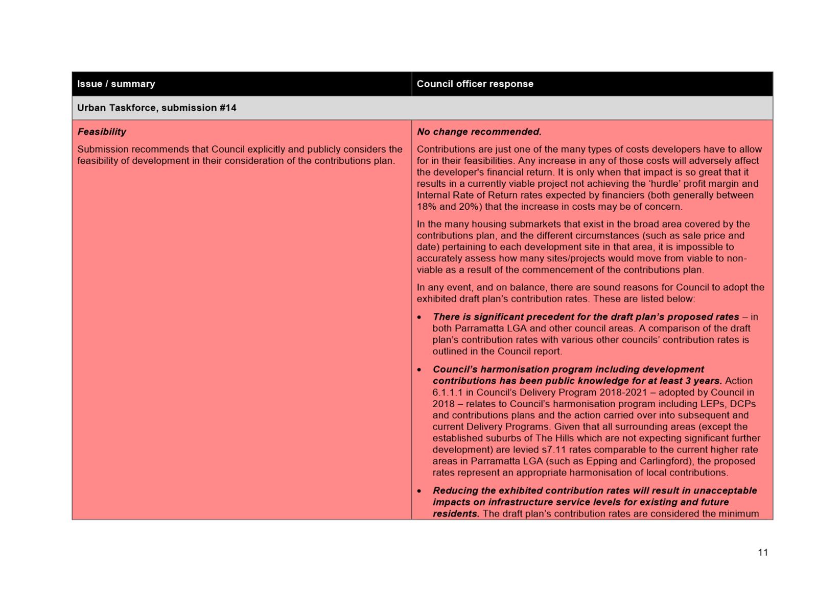
13.1 FOR NOTATION: Variations to Standards under Clause 4.6 of Parramatta LEP 2011, Auburn LEP 2010, Holroyd LEP 2013, The Hills LEP 2012, Hornsby LEP 2013............................... 26
13.2 FOR APPROVAL: Public Exhibition of Alfred Street pedestrian and cyclist upgrade, and T-Way Cycleway re-alignment............................... 30
13.3 FOR APPROVAL: Reappointment of Alternative Members for the Sydney Central City Planning Panel................ 60
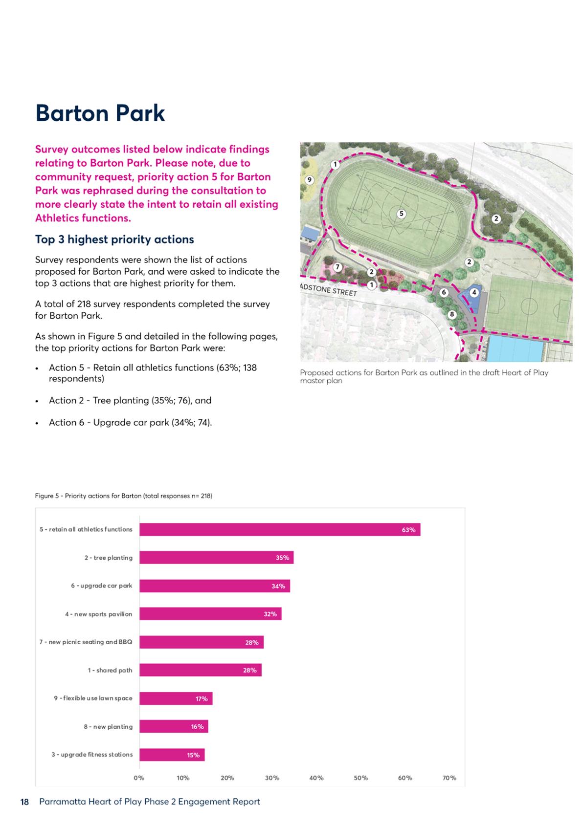
14.1 FOR APPROVAL: Adoption of the Heart of Play Masterplan.. 66
Nil
16.1 FOR APPROVAL: Adoption of the Hill Road Masterplan...... 164
17.1 FOR APPROVAL: Post Gateway - Draft Planning Agreement for 22 Noller Parade, Parramatta........................... 286
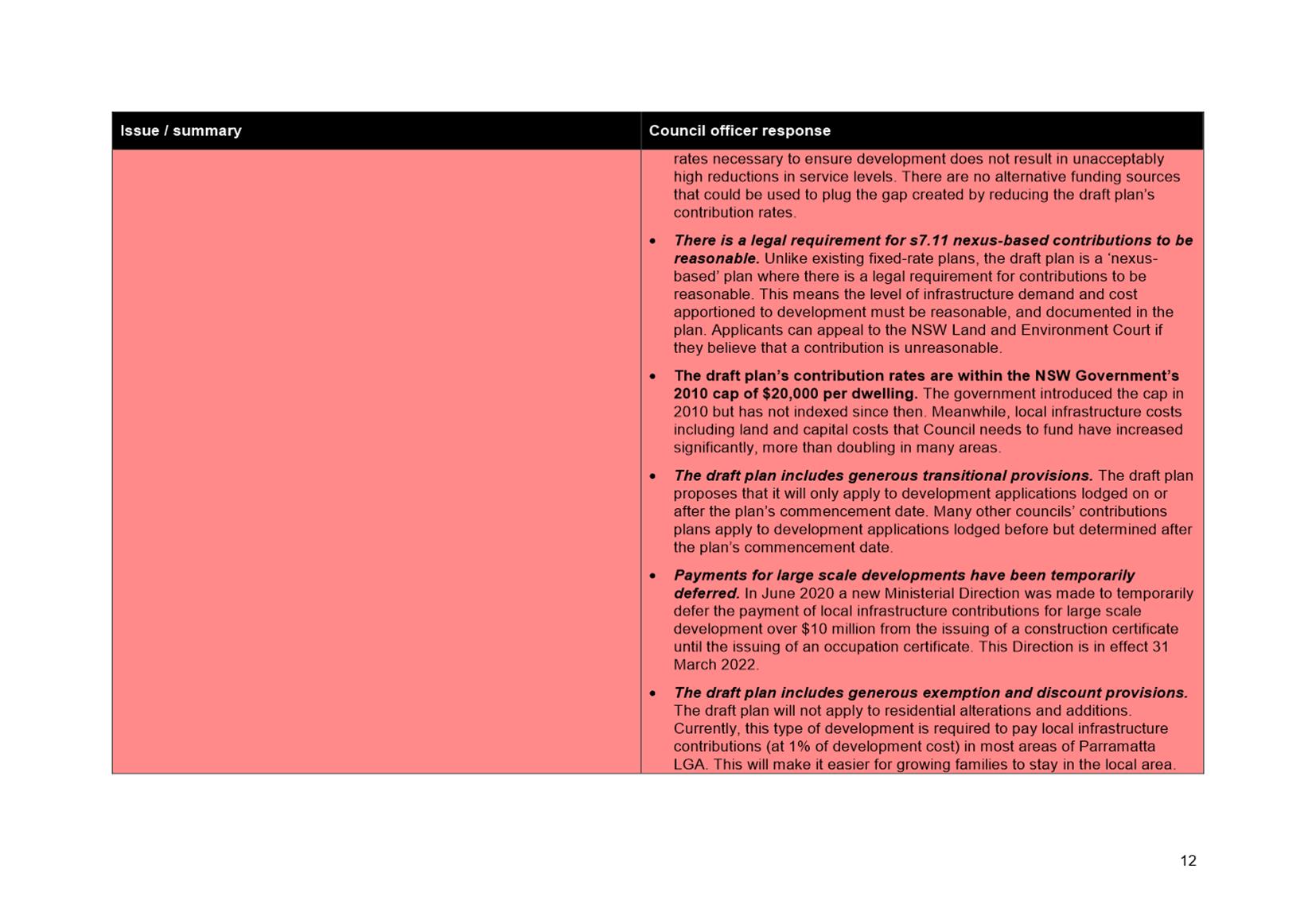
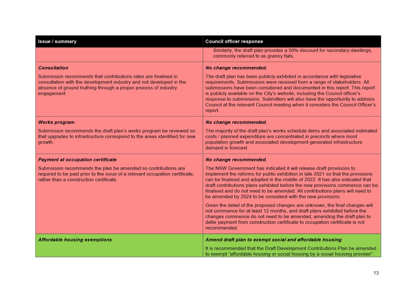
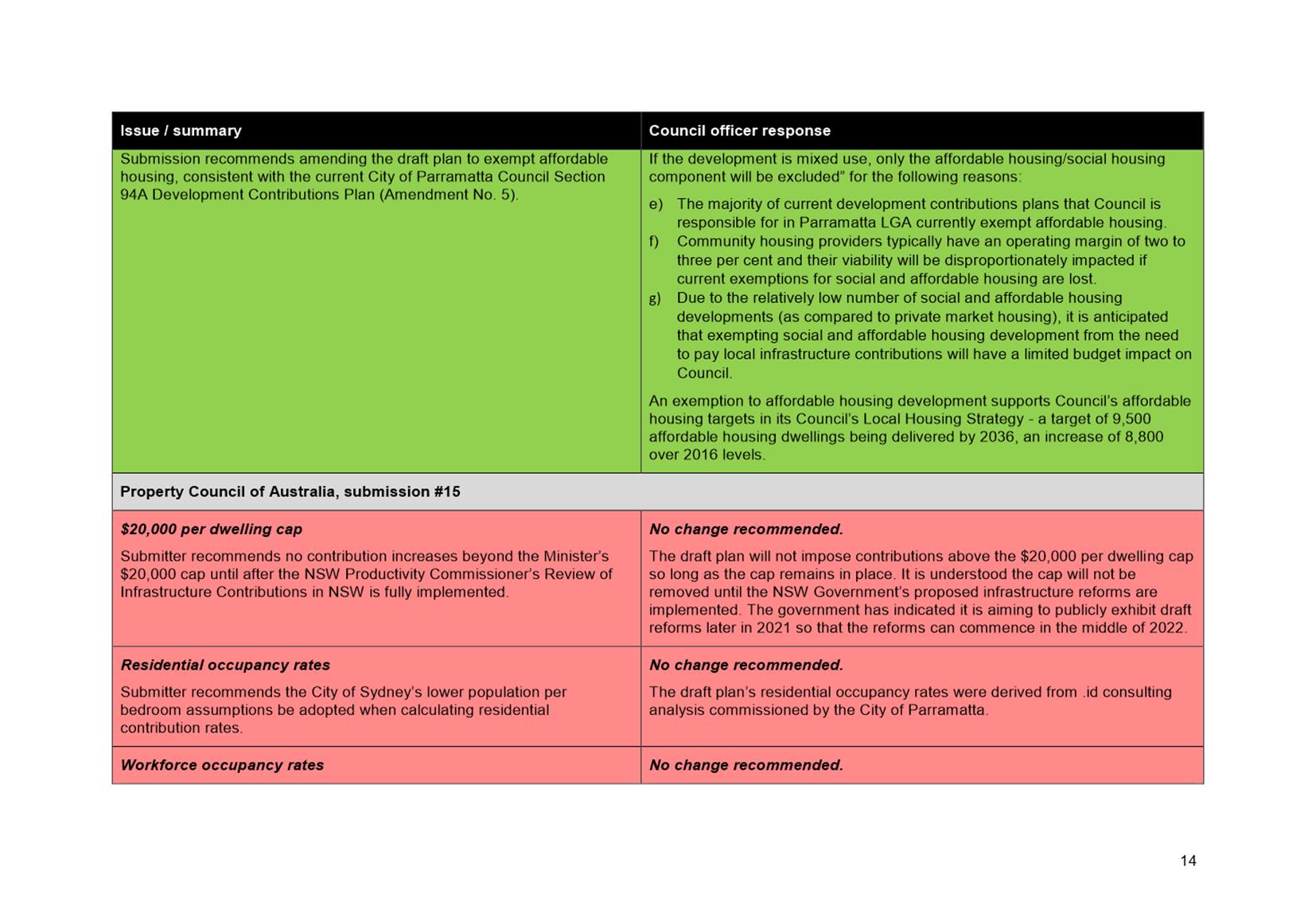
17.2 FOR APPROVAL: Post Exhibition - Draft City of Parramatta (Outside CBD) Development Contributions Plan 2021..................................... 300
17.3 FOR APPROVAL: Post Exhibition - Finalisation of the Harmonisation Planning Proposal and Draft Parramatta LEP following consideration of submissions received during the public exhibition period......... 470
18.1 NOTICE OF MOTION: Probity Checks for Chair, Alternate Chair and Independent Experts for the City of Parramatta Local Planning Panel..................... 512
Nil
20.1 FOR APPROVAL: Tender 06/2021 HR Systems
This report is confidential in accordance with section 10A (2) (d) of the Local Government Act 1993 as the report contains commercial information of a confidential nature that would, if disclosed (i) prejudice the commercial position of the person who supplied it; or (ii) confer a commercial advantage on a competitor of the Council; or (iii) reveal a trade secret.
20.2 FOR APPROVAL: 2021 Community Events Grant Funding
This report is confidential in accordance with section 10A (2) (d) of the Local Government Act 1993 as the report contains commercial information of a confidential nature that would, if disclosed (i) prejudice the commercial position of the person who supplied it; or (ii) confer a commercial advantage on a competitor of the Council; or (iii) reveal a trade secret.
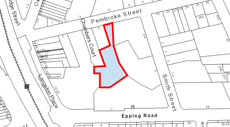
20.3 FOR APPROVAL: 12-22 Langston Place, Epping - Granting of Easements and Transfer of Land
This report is confidential in accordance with section 10A (2) (c) (d) of the Local Government Act 1993 as the report contains information that would, if disclosed, confer a commercial advantage on a person with whom the Council is conducting (or proposes to conduct) business; AND the report contains commercial information of a confidential nature that would, if disclosed (i) prejudice the commercial position of the person who supplied it; or (ii) confer a commercial advantage on a competitor of the Council; or (iii) reveal a trade secret.
20.4 FOR APPROVAL: Charles Street Square
This report is confidential in accordance with section 10A (2) (c) (d) of the Local Government Act 1993 as the report contains information that would, if disclosed, confer a commercial advantage on a person with whom the Council is conducting (or proposes to conduct) business; AND the report contains commercial information of a confidential nature that would, if disclosed (i) prejudice the commercial position of the person who supplied it; or (ii) confer a commercial advantage on a competitor of the Council; or (iii) reveal a trade secret.
21 PUBLIC ANNOUNCEMENT OF RESOLUTIONS PASSED IN CLOSED SESSION
22 CONCLUSION OF MEETING
After the conclusion of the Council Meeting, and if time permits, Councillors will be provided an opportunity to ask questions of staff.
MINUTES OF THE Meeting of City of Parramatta Council HELD VIA AUDIO-VISUAL MEANS ON Wednesday, 28 June 2021 AT 6:30pm
These are draft minutes and are subject to confirmation by Council at its next meeting. The confirmed minutes will replace this draft version on the website once confirmed.
Note: In light of the NSW State Government announcement of stay at home orders on Saturday, 26 June 2021 the Council Meeting was held via audio-visual means.
PRESENT
The Lord Mayor, Councillor Bob Dwyer and Councillors Benjamin Barrak, Phil Bradley, Donna Davis, Pierre Esber, Michelle Garrard (Deputy Lord Mayor), Andrew Jefferies, Sameer Pandey, Dr Patricia Prociv, Bill Tyrrell, Andrew Wilson, Lorraine Wearne and Martin Zaiter.
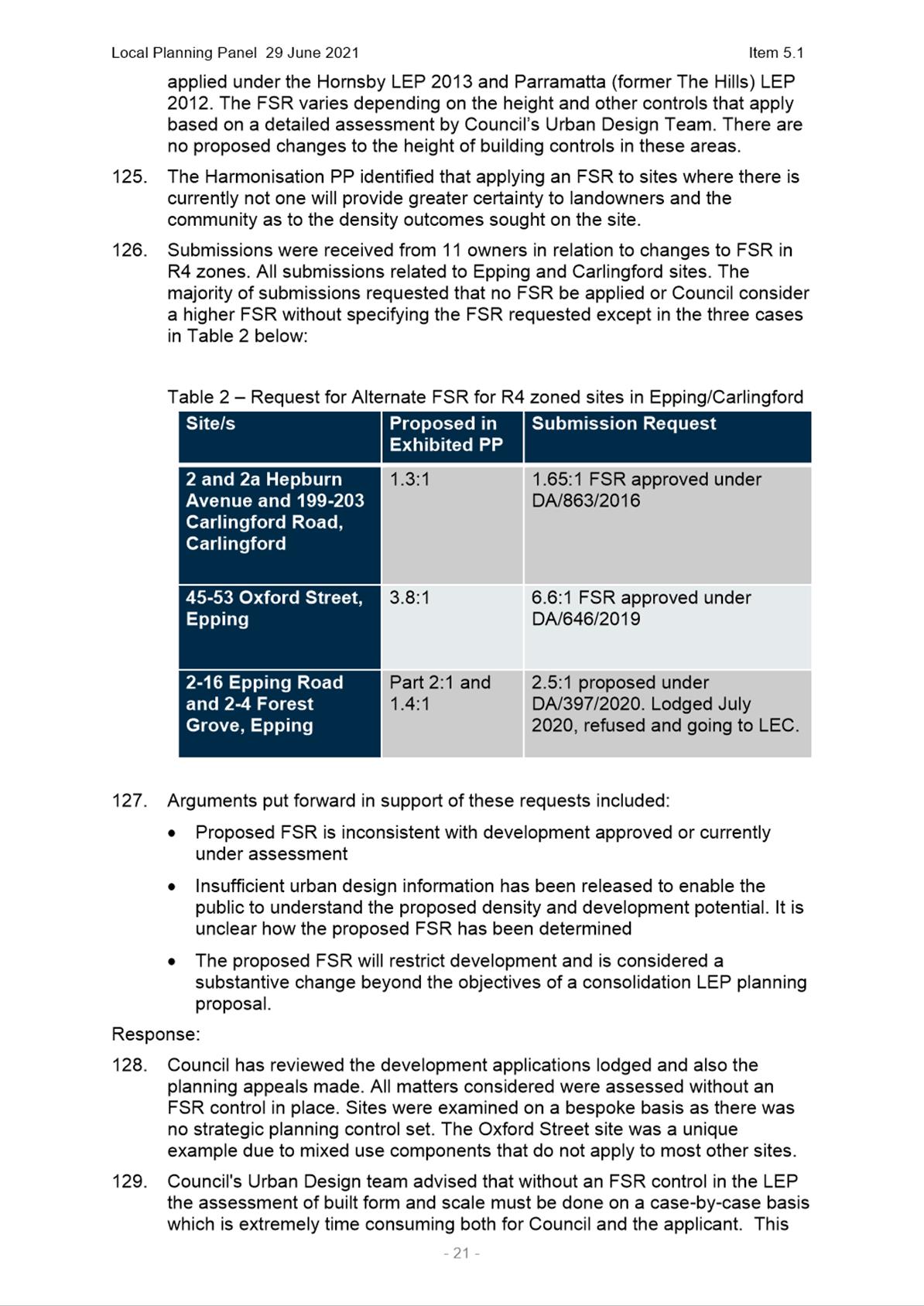
1. OPENING MEETING
The Lord Mayor, Councillor Bob Dwyer, opened the meeting at 6.31pm.
2. ACKNOWLEDGEMENT OF THE TRADITIONAL LAND OWNERS
The Lord Mayor, acknowledged the Burramattagal people of The Darug Nation as the traditional custodians of this land, and paid respect to their ancient culture and their elders past and present.
3. WEBCASTING ANNOUNCEMENT
The Lord Mayor, advised that this public meeting is being recorded and streamed live on the internet. The recording will also be archived and made available on Council’s website.
4. OTHER RECORDING OF MEETING ANOUNCEMENT
Nil
5. CONFIRMATION OF MINUTES
|
|
SUBJECT: Minutes of the Council Meeting held on 15 June 2021
|
|
3288 |
RESOLVED (Esber/Garrard)
That the minutes be taken as read and be accepted as a true record of the Meeting. |
|
|
SUBJECT: Minutes of the Extraordinary Council Meeting held on 23 June 2021
|
|
3289 |
RESOLVED (Tyrrell/Esber)
That the minutes be taken as read and be accepted as a true record of the Meeting. |
6. APOLOGIES/REQUESTS FOR LEAVE OF ABSENCE/REMOTE ATTENDANCE
|
3290 |
RESOLVED (Wearne/Jefferies)
That the request to attend the Ordinary Council Meeting dated 28 June 2021 via remote means submitted by the following Councillors due to personal reasons, be accepted: - Councillor Barrak - Councillor Bradley - Councillor Davis - Councillor Esber - Councillor Garrard - Councillor Jefferies - Councillor Pandey - Councillor Prociv - Councillor Tyrrell - Councillor Wearne - Councillor Wilson - Councillor Zaiter
|
|
3291 |
RESOLVED (Esber/Wilson)
That the apologies received from Councillor Steven Issa due to personal reasons be accepted and leave of absence granted. |
7. DECLARATIONS OF INTEREST
There were no Declarations of Interest made at this meeting.
8. Minutes of the Lord Mayor
|
8.1 |
SUBJECT Council Projects Recognised in NSW Award Programs
REFERENCE F2019/03630 - D08117529
REPORT OF Lord Mayor, Councillor Bob Dwyer
|
|||||||||||||||||||||||||||||||||||||||||||||||||||||||||
|
3292 |
RESOLVED (Dwyer/Bradley)
(a) That Council note several City of Parramatta Council projects have recently been nominated for, and won, a number of NSW based award programs that celebrate excellence in planning and recognise outstanding collaborative, innovative and bold initiatives that deliver benefits to local communities.
(b) That Council note the Carmen Drive Reinvigoration Project won the Great Community Collaboration Award at the 2021 Greater Sydney Planning Awards, presented by Greater Sydney Commission on 22 June 2021.
(c) That Council note the Escarpment Boardwalk and Melrose Park: Smart Planning for Climate Responsive Neighbourhoods projects were also nominated at the 2021 Greater Sydney Planning Awards, as finalists in the Great Sustainability Initiative and Planning Disruptor Award categories respectively.
(d) That Council note the Max Ruddock Reserve Playground upgrade won the 2021 AILA NSW Landscape Architecture Award for Small Projects, presented on 9 June 2021.
(e) That Council note eight place-making projects were finalists in the 2021 NSW Local Government Excellence Awards presented by Local Government Professionals Australia NSW on 3 June 2021.
(f) That Council congratulate the following staff and their teams who have delivered these projects on these fantastic achievements and thank them for their hard work and dedication to designing and delivering projects for the benefit of our communities:
(g) Further, that Council note Council is also nominated for several awards in the 2021 Place Leaders Awards presented by Place Leaders Asia Pacific on Tuesday 17 August 2021 and wish our project teams the best of luck for these awards. |
|
8.2 |
SUBJECT NSW Veterans Strategy 2021-2024
REFERENCE F2019/03630 - D08118493
REPORT OF Lord Mayor, Councillor Bob Dwyer
|
|
3293 |
RESOLVED (Dwyer/Wilson)
(a) That Council note the NSW Veterans Strategy 2021-2024 and supporting Action Plan was released by the NSW Government on 25 April 2021, which identifies Local Government as a Preferred Employer under ‘Theme 2 – Education and Employment’.
(b) That Council staff seek a meeting with the NSW Office of Veterans Affairs to be briefed on the strategy, its underlying themes, and their targets identified in the Strategy and supporting Veterans Strategy Action Plan.
(c) That a report be brought back to Council in December 2021 following this consultation that considers the NSW Veterans Strategy 2021-2024 and any current and future opportunities for Council to partner or utilise the resources and actions being developed by the NSW Government to support veterans employment initiatives.
(d) Further, that Council seek input from local RSLs and veterans within the Local Government Area. |
|
8.3 |
SUBJECT 60th Anniversary of the commissioning of HMAS Parramatta III
REFERENCE F2019/03630 - D08118813
REPORT OF Lord Mayor, Councillor Bob Dwyer
|
|
3294 |
RESOLVED (Dwyer/Wilson)
(a) That Council note that 4 July 2021 will be the 60th anniversary of the commissioning of the HMAS Parramatta III, which was commissioned by the Royal Australian Navy (RAN) at Sydney on 4 July 1961 under the command of Commander Guy Griffiths, DSC RAN.
(b) Further, that Council write to the appropriate officer within the Royal Australian Navy congratulating and acknowledging the importance of Council’s ongoing relationship with the HMAS Parramatta III. |
9. Public Forum
There were no public forums at the meeting.
10. Petitions
|
10.1 |
SUBJECT A fenced off-leash dog area, West Epping Park, Epping 2121
FROM Donna Davis
|
|
|
A petition signed by the public was tabled at the Council Meeting and reads:
“On behalf of the Residents and Dog Owners in Epping and surrounds, we request the Council to provide to our community a dog off leash exercise facility in originally envisaged Area 18, covering two grassy areas adjacent to the Tennis Courts. This was promised five years ago, but never completed. The area is small, but adequate.
There are no such facilities available on foot in here, except driving dogs in cars and over the bridge to North Epping.
It appears that dog ownership has significantly increased since the last year, so did the population density, and it is now the time that something should be done in this matter.”
|
|
3295 |
RESOLVED (Davis/Esber)
That the supplementary petition be received and accepted. |
11. Rescission Motions
Nil
|
|
Procedural Motion
|
|
3296 |
RESOLVED (Tyrrell/Esber)
That Items 12.1, 12.3, 13.3, 15.1, 17.1 and 17.2 be resolved enbloc. |
12. Fair
|
12.1 |
SUBJECT FOR NOTATION: Investment Report for May 2021
REFERENCE F2021/00521 - D08083675
REPORT OF Tax and Treasury Accountant
|
|
3297 |
RESOLVED (Tyrrell/Esber)
That Council receive the Investment Report for May 2021. |
|
12.2 |
SUBJECT FOR APPROVAL: Adoption of the Delivery Program Year Four: Operational Plan and Budget 2021/22
REFERENCE F2019/04433 - D07809569
REPORT OF Corporate Strategy Manager
|
|
3298 |
RESOLVED (Davis/Esber)
(a) That Council adopt the Delivery Program 2018-22 and Operational Plan and Budget 2021/22, inclusive of the Annual Budget and Schedule of Fees and Charges, as outlined in this report and included as Attachments 1 and 2.
(b) That in adopting the Delivery Program, Operational Plan and Budget 2021/22, it is noted that Council has taken into consideration submissions received via the public exhibition of the documents.
(c) That Council adopt expenditure totalling $607.5m in the Operational Plan and Budget 2021/22 (incorporating the draft operating and capital budgets) and the funds to cover such expenditure be voted.
(d) That Council reinstate Focus Area 3.4.1.1 into the Delivery Program 2018-22.
(e) Further, that the Budget 2021/22 be adjusted in Q1 to include the change approved at the Council Meeting of Tuesday, 15 June 2021 of $1,039,000 for future Council office accommodation options. |
|
12.3 |
SUBJECT FOR APPROVAL: 2021/2022 Making of the Rates and Annual Charges
REFERENCE F2021/00521 - D08090772
REPORT OF Rates & Receivables Manager
|
|
3299 |
RESOLVED (Tyrrell/Esber)
(a) That Council make the Rates and Charges for the 2021/22 Rating year as outlined in this report using the Land Values with a base date valuation of 1 July 2019.
(b) That Council approve an increase to overall rates by 2%, being the maximum amount allowable as determined by the Independent Pricing & Regulatory Tribunal (IPART).
(c) Further, that Council adopt the overdue Rates & Charges maximum interest rate of 6% in accordance with Section 566(3) of the Local Government Act 1993. |
|
12.4 |
SUBJECT FOR APPROVAL: Local Government Remuneration Tribunal Determination - Councillor Fees 2021/22
REFERENCE F2004/06514 - D08088500
REPORT OF Executive Officer
|
|
3300 |
RESOLVED (Tyrrell/Esber)
(a) That Council confirm the setting of Lord Mayor and Councillor annual fees for the period 1 July 2021 to 30 June 2022 at the maximum permissible levels, being $112,520 and $34,820 respectively.
(b) Further, that Council note the Local Government Amendment Act 2021 was passed on 13 May 2021, which provides Councils the option to make superannuation contribution payments for Councillors from 1 July 2022, and a report will be tabled to Council in the first half of 2022 to seek a decision on superannuation contribution payments. |
13. Accessible
|
13.1 |
SUBJECT FOR APPROVAL: Minutes of the Parramatta Traffic Committee meeting held on 26 May 2021
REFERENCE F2021/00082 - D07842536
REPORT OF Traffic and Transport Manager
|
|
3301 |
RESOLVED (Tyrrell/Bradley)
(a) That Council note the minutes of the Parramatta Traffic Committee meeting held on 26 May 2021, as provided at Attachment 1.
(b) That Council approve the recommendations of the Parramatta Traffic Committee meeting held on 26 May 2021 provided at Attachment 1 and in this report, noting the following financial implications for each item.
i. ITEM 2105 A1 VIRGINIA STREET, ROSEHILL – PROPOSED WATTS PROFILE SPEED HUMPS
The estimated cost for the installation of the two Watts Profile Speed Humps is $18,000. This project is 100% funded by Council from its Ward Initiative Funds.
ii. ITEM 2105 A2 EVANS ROAD AT YATES AVENUE, DUNDAS VALLEY – PROPOSED ‘NO LEFT TURN – VEHICLES UNDER 9M EXCEPTED – GARBAGE TRUCKS EXCEPTED’ RESTRICTION
The estimated cost for the installation of the ‘No Left Turn, Vehicles Under 9m Excepted’ sign is $500. This work will be funded from the project costs for the previously approved raised thresholds budget.
iii. ITEM 2105 A3 FITZWILLIAM ROAD, OLD TOONGABBIE – INSTALL A CONCRETE BLISTER ISLAND WITH GUTTER BRIDGE
The estimated cost of the concrete blister island with gutter bridge on the south side of Fitzwilliam Road between Picasso Crescent and Reynolds Street, Old Toongabbie is $60,000. This project is 100% funded by Council from its Ward Initiative Funds.
iv. ITEM 2105 A4 CLOSURE OF ALFRED STREET TO GENERAL TRAFFIC NORTH OF RIVER ROAD WEST, ROSEHILL
The closure of Alfred Street will be implemented as part of the Alfred Street Bridge and Plaza project, which is co-funded by the NSW Government and Council. Accordingly, this proposal has no new financial impact upon Council’s budget. It is to be noted that the budget for the Plaza is $200,000. Of this $200,000, 67% is funded by NSW Government and 33% by Council.
v. ITEM 2105 A5 GOOD STREET AND BRIDGE STREET, GRANVILLE – PROPOSED ONE-WAY RESTRICTION, COMBINED RAISED PEDESTRIAN AND CYCLIST CROSSING AND ROUNDABOUT
This project has received 100% funding of $8 million from the NSW Government under its Parramatta Road Urban Amenity Improvement Program. This PTC item will have no new financial implications to Council. |
|
13.2 |
SUBJECT FOR APPROVAL: Minutes of the Traffic Engineering Advisory Group meeting held on 26 May 2021
REFERENCE F2021/00077 - D07842538
REPORT OF Traffic and Transport Manager
|
|
3302 |
RESOLVED (Davis/Esber)
(a) That Council note the minutes of the Traffic Engineering Advisory Group meeting held on 26 May 2021, provided at Attachment 1.
(b) Further, that Council approve the recommendations of the Traffic Engineering Advisory Group meeting held on 26 May 2021 provided at Attachment 1 and in this report, noting the following financial implications for each item.
i. ITEM 2105 B1 o’connell street and fennell Street, parramatta – proposed left turn only restrictions on Fennell street
At this stage, it is only proposed to undertake community consultation for this proposal and therefore, the cost would be covered under existing budgets.
ii. ITEM 2105 B2 RAWSON STREET, EPPING – REQUEST TO CONSOLIDATE PEDESTRIAN CROSSINGS
This report does not recommend any works in Rawson Street and only proposes consultation for parking changes on Victoria Street north of Bridge Street at this stage. Therefore, this matter has no financial impact upon Council’s budget other than the cost of consultation, which would be covered under existing budgets. The attendees of the meeting included Epping Ward Councillors.
iii. ITEM 2105 B3 MURRAY FARM ROAD EAST OF LYNBRAE AVENUE, BEECROFT – REVIEW DECISION TO RETAIN PEDESTRIAN REFUGE ISLAND
This report recommends that the removal of the pedestrian refuge island and the associated ‘No Stopping’ restrictions as the preferred future treatment. The approximate cost for these works is $20,000 and is currently unfunded. This project will be considered for future funding.
iv. ITEM 2105 B4 SAFETY OF PEDESTRIANS AND FOOD DELIVERY BIKE RIDERS – ‘WORKING TOGETHER TO IMPROVE FOOD DELIVERY RIDER SAFETY INDUSTRY ACTION PLAN 2021- 2022’ RELEASED BY THE FOOD DELIVERY RIDERS SAFETY TASKFORCE (LED BY SAFEWORK NSW AND TRANSPORT FOR NSW)
The Taskforce findings have no financial impact upon Council's budget. The cost of installation of new signs and maintenance of existing signs will involve staff time with an approximate value of $250 from within existing employee budgets, and an expenditure of $1,000 from the Traffic and Transport promotions budget allocated for the signs.
v. ITEM 2105 B5 PROJECTS RECENTLY COMPLETED, PROJECTS CURRENTLY FUNDED, AND PROJECTS LISTS FOR CONSIDERATION OF FUTURE FUNDING
There is no financial implication to Council as a result of this recommendation.
vi. ITEM 2105 B6 OUTSTANDING WORKS INSTRUCTIONS
Transport for NSW Block Grant funds for 2020/21 have been used for these works. |
|
13.3 |
SUBJECT FOR APPROVAL: Appointment of City of Parramatta Local Planning Panel Chair, Alternate Chairs and Independent Expert Members
REFERENCE F2016/02347 - D08064012
REPORT OF Strategic Business Manager
|
|
3303 |
RESOLVED (Tyrrell/Esber)
(a) That Council note the advice from the Minister for Planning and Public Spaces approving Mr Steve O’Connor as Chair and Ms Julie Walsh and Mrs Mary-Lynne Taylor as alternate chairs for appointment to the City of Parramatta Local Planning Panel.
(b) That Council appoint Steve O’Connor as Chair and Julie Walsh and Mary-Lynne Taylor as alternate chairs for the City of Parramatta Local Planning Panel.
(c) That Council acknowledge and thank the outgoing panel Chair The Hon. David Lloyd QC for his contribution to the City of Parramatta Local Planning Panel over the past five years.
(d) That Council appoint those independent experts as contained in Attachment 2 to the City of Parramatta Local Planning Panel.
(e) Further, that the Authority of Delegation for the City of Parramatta Local Planning Panel be amended to reflect the membership as determined by the Council. |
14. Green
Nil
15. Welcoming
|
15.1 |
SUBJECT FOR NOTATION: Minutes of the Riverside Advisory Board Meeting held on 10 December 2020 and 25 February 2021
REFERENCE F2007/00388 - D08089497
REPORT OF Director Riverside Theatres
|
|
3304 |
RESOLVED (Tyrrell/Esber)
That Council note the Minutes of the Riverside Theatres Advisory Board Meetings held on 10 December, 2020 and 25 February, 2021 (Attachment 1 and 2). |
|
15.2 |
SUBJECT FOR APPROVAL: 2021 Olympic Games Live Site
REFERENCE F2021/00521 - D08069170
REPORT OF Acting Group Manager, City Experience
|
|
3305 |
RESOLVED (Wearne/Davis)
That Council defer consideration of this matter for a period of two (2) weeks for a report to be brought back to Council considering the current COVID climate and the effect on the Live Site. |
16. Thriving
|
16.1 |
SUBJECT FOR APPROVAL: Response to Notice of Motion - Re-establishment of the Wentworth Point Working Group
REFERENCE F2021/00521 - D08062287
REPORT OF Group Manager City Engagement
|
|
3306 |
RESOLVED (Prociv/Wilson)
(a) That Council not re-establish the Wentworth Point Working Group as there is no identified budget and staff resource for ongoing co-ordination, administration, and end-to-end delivery of each working group meeting, and to mitigate a reasonable community perception that any precinct without such a working group is being less-served by Council.
(b) That Council collaborate with the Sydney Olympic Park Authority (SOPA) to develop a Wentworth Point ‘Place Plan’ that aligns with Council’s Strategic documents, SOPA’s Place Vision and Strategy update occurring in 2021-22, and the work underway for the Greater Parramatta and Olympic Peninsula (GPOP) and the Central River city by the broader NSW Government.
(c) That Council note that development of the Wentworth Point ‘Place Plan’ will include four meetings in the 2021-22 financial year with residents and representatives of the various Wentworth Point Community groups and that the Wentworth Point Place Plan’s ‘all-of-suburb’ community engagement will provide a voice to all residents of Wentworth Point - including CALD communities - who would otherwise be excluded from effective participation in Working Group meetings.
(d) That Council work with SOPA and the community of Wentworth Point to establish a community-led Wentworth Point ‘Town Team’ as a model for community empowerment and outcomes through consensus decision-making.
(e) Further, that Council approve a budget of $160,000 in the 2021/22 financial year to fund the facilitation of multiple suburb-wide community engagement activities, to be funded from General Revenue. |
|
16.2 |
SUBJECT FOR APPROVAL: Better Neighbourhood Program 21/22 and 22/23 (Deferred Item)
REFERENCE F2021/00521 - D08102410
REPORT OF Senior Project Officer Place Services
|
|
|
MOTION (Esber/Barrak)
(a) That Council approve the final list of projects for delivery within the approved budget for the Better Neighbourhood Program (BNP) in the 2021/22 and 2022/23 financial years (Attachment 1).
(b) That for centres where public domain is under private ownership, Council approve works to be carried out on private land for existing and proposed projects initiated under the BNP, including funding 30% of the total cost of the private works, to a maximum dollar value of $20,000 per rateable property, in alignment with the financial contribution model and maximum financial contribution threshold in Council’s endorsed Retail Frontage Improvement Program.
(c) That Council delegate authority to the Chief Executive Officer (CEO) to negotiate, finalise and execute agreements with private property owners for existing and proposed projects initiated under the BNP generally in accordance with the financial model set out in Recommendation (b).
(d) That Council delegate authority to the Chief Executive Officer (CEO) to negotiate, finalise and execute agreements with private property owners for existing and proposed projects initiated under the BNP for a proposed public funding contribution greater than the financial model set out in Recommendation (b), including up to 100% of public funding for works on private land in the following circumstances: 1 When works are proposed for three or more rateable properties at a single centre; or 2 For the installation of creative artworks; or 3 For works that improve disability access; or 4 When the private property owner(s) undertakes shopfront improvement works or commit to providing increased maintenance generally equivalent in cost of works to the financial model set out in Recommendation (b); or 5 For works on private land that constitute less than 10% of the overall cost of works; or 6 For works that are in the public interest, as evidenced by outcomes of site-specific community consultation.
(e) Further, that a report be presented to Council in accordance with Section 67(4) of the Local Government Act 1993 at the conclusion of the 2021-2023 Better Neighbourhood Program as outlined in Paragraph 15.
|
|
|
AMENDMENT (Garrard/Wilson)
(a) That Council approve the final list of projects for delivery within the approved budget for the Better Neighbourhood Program (BNP) in the 2021/22 and 2022/23 financial years (Attachment 1).
(b) That for centres where public domain is under private ownership, Council approve works to be carried out on private land for existing and proposed projects initiated under the BNP, including funding 30% of the total cost of the private works, to a maximum dollar value of $20,000 per rateable property, in alignment with the financial contribution model and maximum financial contribution threshold in Council’s endorsed Retail Frontage Improvement Program.
(c) Further, that a report be presented to Council in accordance with Section 67(4) of the Local Government Act 1993 at the conclusion of the 2021-2023 Better Neighbourhood Program as outlined in Paragraph 15.
|
|
|
The motion moved by Councillor Esber and seconded by Councillor Barrak was WITHDRAWN.
The amendment moved by Councillor Garrard and seconded by Councillor Wilson then became the MOTION.
|
|
|
FORESHADOWED MOTION (Esber/Barrak)
That Council defer consideration of this matter for a period of two (2) weeks.
|
|
|
The motion moved by Councillor Garrard and seconded by Councillor Wilson on being put was declared CARRIED.
|
|
3307 |
RESOLVED (Garrard/Wilson)
(a) That Council approve the final list of projects for delivery within the approved budget for the Better Neighbourhood Program (BNP) in the 2021/22 and 2022/23 financial years (Attachment 1).
(b) That for centres where public domain is under private ownership, Council approve works to be carried out on private land for existing and proposed projects initiated under the BNP, including funding 30% of the total cost of the private works, to a maximum dollar value of $20,000 per rateable property, in alignment with the financial contribution model and maximum financial contribution threshold in Council’s endorsed Retail Frontage Improvement Program.
(c) Further, that a report be presented to Council in accordance with Section 67(4) of the Local Government Act 1993 at the conclusion of the 2021-2023 Better Neighbourhood Program as outlined in Paragraph 15. |
17. Innovative
|
17.1 |
SUBJECT FOR NOTATION: Minutes of the 5/7 Parramatta Square Advisory Group Meeting held on 6 May 2021 (Deferred Item)
REFERENCE F2021/00521 - D08100001
REPORT OF Business Governance Officer
|
|
3308 |
RESOLVED (Tyrrell/Esber)
That Council receive and note the minutes of the 5/7 Parramatta Square Advisory Group meeting held on 6 May 2021. |
|
17.2 |
SUBJECT FOR APPROVAL: Minutes of the Heritage Advisory Committee Meeting held on 15 April 2021
REFERENCE F2021/00521 - D08086265
REPORT OF Project Officer Land Use
|
|
3309 |
RESOLVED (Tyrrell/Esber)
(a) That Council receive and note the minutes of the Heritage Advisory Committee meeting of 15 April 2021.
(b) Further, that Council approve the Heritage Grants recommendation, as included in Item 11 of Attachment 1, to make a grant of $3,300 for 77 Weston Street, Harris Park. |
18. Notices of Motion
|
18.1 |
SUBJECT NOTICE OF MOTION: Music Markets Wentworth Point
REFERENCE F2021/00521 - D08094757
FROM Councillor Wilson
|
|
3310 |
RESOLVED (Wilson/Bradley)
That the City of Parramatta Council prepare a report to examine if Council can support the markets at Wentworth Point with live music. |
|
18.2 |
SUBJECT NOTICE OF MOTION: Indian Flag Raising Ceremony
REFERENCE F2021/00521 - D08101282
FROM Councillor Pandey
|
|
|
MOTION (Pandey/Barrak)
(a) That Council host a flag-raising civic event for Indian Independence Day, to be held on 15 August 2021.
(b) Further, that an invitation is extended to the Consul General of India Sydney to attend the event.
|
|
|
FORESHADOWED MOTION (Wearne/Garrard)
That no further action be taken.
The foreshadowed motion moved by Councillor Wearne and seconded by Councillor Garrard was WITHDRAWN.
|
|
|
AMENDMENT (Wearne/Garrard)
That Council set a timeframe for the review of current Council policies including and policy incorporating Flag Raising Ceremonies.
The amendment moved by Councillor Wearne and seconded by Councillor Garrard was WITHDRAWN.
|
|
|
AMENDMENT (Zaiter/Tyrrell)
(a) That Council reinstate the Flag Raising Program previously suspended by Council at its meeting of 24 February 2020.
(b) Further, that a report on alternate locations for flag raising ceremonies be provided to Council due to Centenary Square being unavailable as a result of construction works.
The amendment moved by Councillor Zaiter and seconded by Councillor Tyrrell was accepted by Councillor Pandey and Councillor Barrak and became the MOTION.
The motion moved by Councillor Pandey and seconded by Councillor Barrak on being put was declared CARRIED.
|
|
3311 |
RESOLVED (Pandey/Barrak)
(a) That Council reinstate the flag raising program suspended by Council at its meeting of 24 February 2020.
(b) Further, that a report on alternate locations for flag raising ceremonies be provided to Council due to Centenary Square being unavailable as a result of construction works. |
19. Questions with Notice
|
19.1 |
SUBJECT QUESTION WITH NOTICE: CBD Planning Proposal & Infrastructure Contributions Review
REFERENCE F2021/00521 - D08101310
FROM Councillor Bradley
|
|
|
QUESTIONS WITH NOTICE
Can the Chief Executive Officer please locate and provide the response from Minister Stokes to all Councillors and be included with the Lord Mayor’s letter in the 28 June Council papers.
CHIEF OF STAFF, CHIEF EXECUTIVE OFFICE RESPONSE
Correspondence was provided as requested. The letter was received on 15 June and distributed to all Councillors by e-mail on 16 June 2021. |
|
|
Matter of Urgency
|
|
3312 |
RESOLVED (Pandey/Wilson)
That a procedural motion be granted to allow consideration of a matter of urgency in relation to contractors of Parramatta Light Rail not following guidelines of COVID-19.
The Lord Mayor ruled the matter urgent. |
|
|
Resolution
|
|
3313 |
RESOLVED (Pandey/Davis)
That Council write to the Minister for Transport and Infrastructure requesting contractors and staff working on the Parramatta Light Rail Project to follow COVID safe guidelines including the wearing masks while interacting with the community members. |
|
20. CLOSED SESSION
|
|
|
3314 |
RESOLVED (Esber/Bradley)
That members of the press and public be excluded from the meeting of the Closed Session and access to the correspondence and reports relating to the items considered during the course of the Closed Session be withheld. This action is taken in accordance with Section 10A(s) of the Local Government Act, 1993 as the items listed come within the following provisions: 1 FOR NOTATION: Legal Status Report as at 31 May 2021. (D08052240) - This report is confidential in accordance with section 10A (2) (g) of the Local Government Act 1993 as the report contains advice concerning litigation, or advice that would otherwise be privileged from production in legal proceedings on the ground of legal professional privilege. 2 FOR APPROVAL: Tender 14/2021 Epping Library and Leisure & Learning Centre Refurbishment Works, Chambers Court, Epping. (D08024817) - This report is confidential in accordance with section 10A (2) (d) of the Local Government Act 1993 as the report contains commercial information of a confidential nature that would, if disclosed (i) prejudice the commercial position of the person who supplied it; or (ii) confer a commercial advantage on a competitor of the Council; or (iii) reveal a trade secret. 3 FOR APPROVAL: 2022 Sydney Festival Agreement. (D08066715) - This report is confidential in accordance with section 10A (2) (d) of the Local Government Act 1993 as the report contains commercial information of a confidential nature that would, if disclosed (i) prejudice the commercial position of the person who supplied it; or (ii) confer a commercial advantage on a competitor of the Council; or (iii) reveal a trade secret. |
|
|
Procedural Motion
|
|
3315 |
RESOLVED (Esber/Garrard)
That items 20.1, 20.2 and 20.3 be resolved enbloc. |
|
20.1 |
SUBJECT FOR NOTATION: Legal Status Report as at 31 May 2021
REFERENCE F2020/03849 - D08052240
REPORT OF Group Manager Legal Services
|
|
3316 |
RESOLVED (Esber/Garrard)
That Council note the Legal Status Report as at 31 May 2021 |
|
20.2 |
SUBJECT FOR APPROVAL: Tender 14/2021 Epping Library and Leisure & Learning Centre Refurbishment Works, Chambers Court, Epping
REFERENCE F2021/00448 - D08024817
REPORT OF Manager Capital Projects
|
|
3317 |
RESOLVED (Esber/Garrard)
(a) That Council approve the appointment of the preferred proponent for refurbishment work at Epping Library and Leisure & Learning Centre, Chambers Court, Epping for the contract sum as outlined in paragraph 11 of the report.
(b) That all unsuccessful tenderers be advised of Council’s decision in this matter.
(c) Further, that Council delegate authority to the Chief Executive Officer to finalise and execute all necessary documents. |
|
20.3 |
SUBJECT FOR APPROVAL: 2022 Sydney Festival Agreement
REFERENCE F2021/00521 - D08066715
REPORT OF Acting Group Manager, City Experience
|
|
3318 |
RESOLVED (Esber/Garrard)
(a) That Council enter a one-year partnership with Sydney Festival Limited to deliver the 2022 Sydney Festival in Parramatta in January 2022.
(b) That Council provide a financial commitment from the 2021/2022 operational budget, for the presentation of the 2022 Sydney Festival in Parramatta, to the amount of $500,000 (ex GST).
(c) Further, that Council delegate authority to the Chief Executive Officer to finalise and execute an agreement between Sydney Festival Limited and Council. |
|
|
Procedural Motion
|
|
3319 |
RESOLVED (Garrard/Barrak)
That the meeting resume in open session. |
21. REPORTS OF RESOLUTIONS PASSED IN CLOSED SESSION
The Chief Executive Officer read out the resolutions for Items 20.1 to 20.3.
22. CONCLUSION OF MEETING
The meeting terminated at 8:24pm.
THIS PAGE AND THE PRECEDING 17 PAGES ARE THE MINUTES OF THE ORDINARY COUNCIL MEETING HELD ON MONDAY, 28 JUNE 2021 AND CONFIRMED ON MONDAY, 12 JULY 2021.
Chairperson
Accessible
12 July 2021
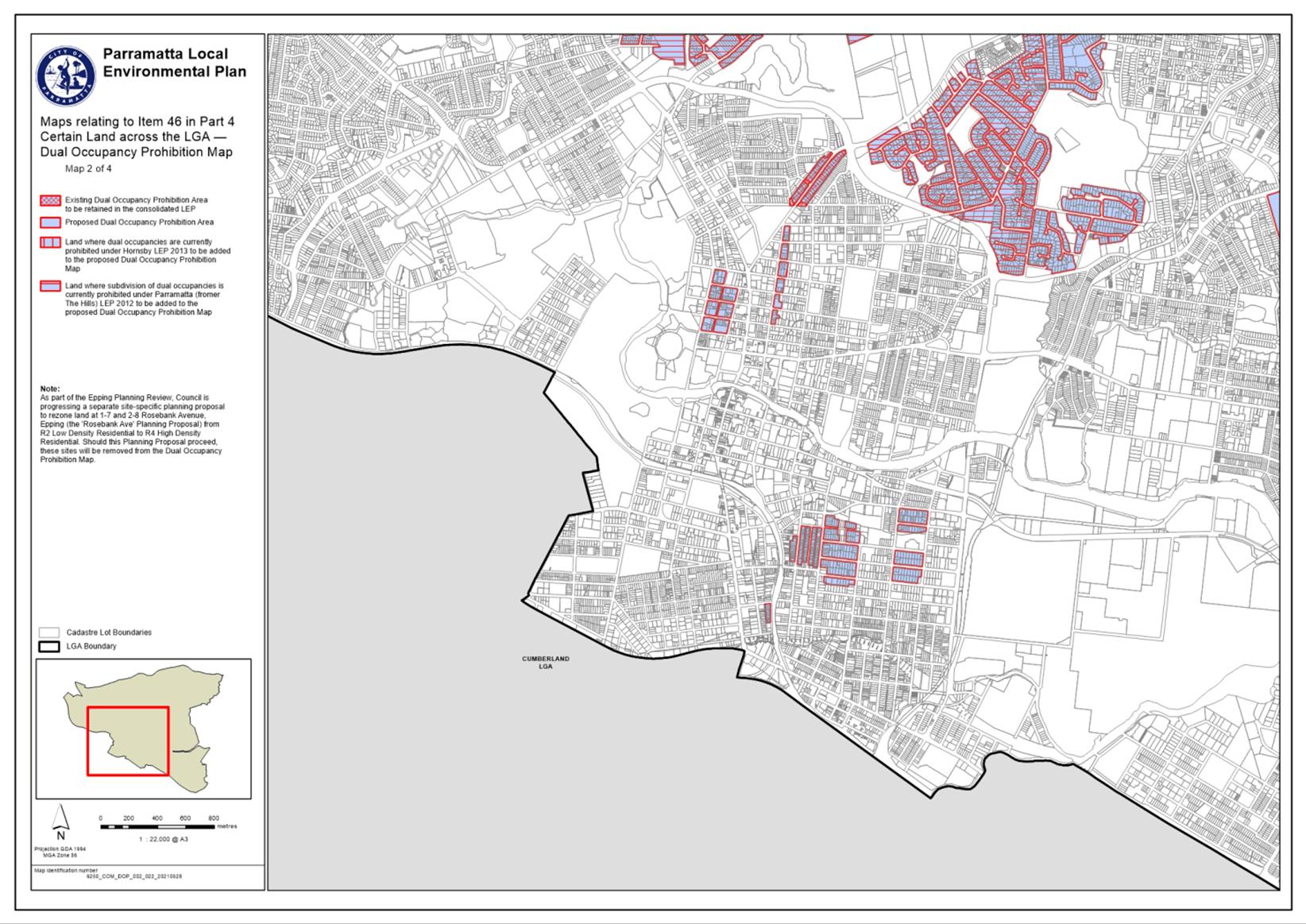
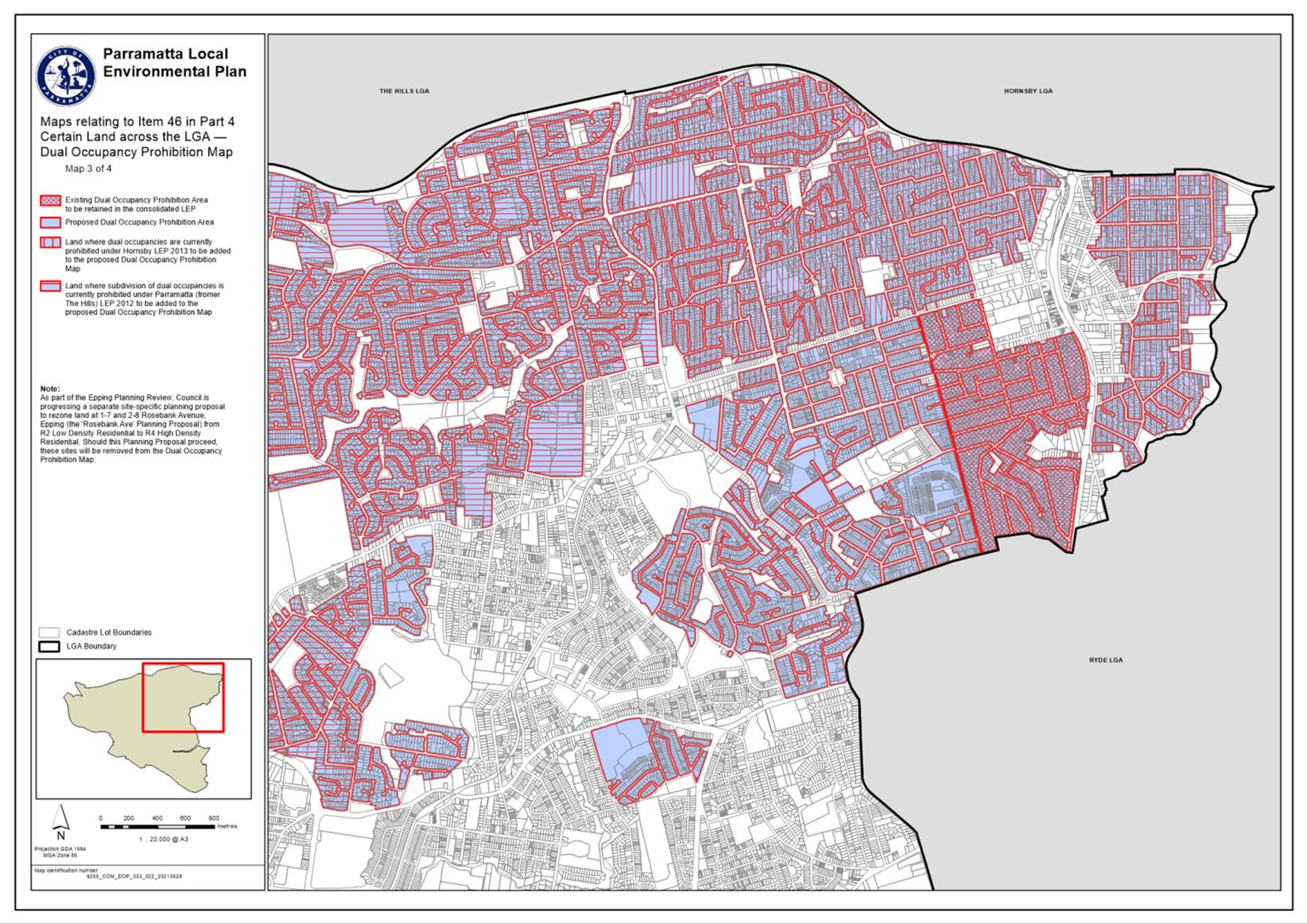
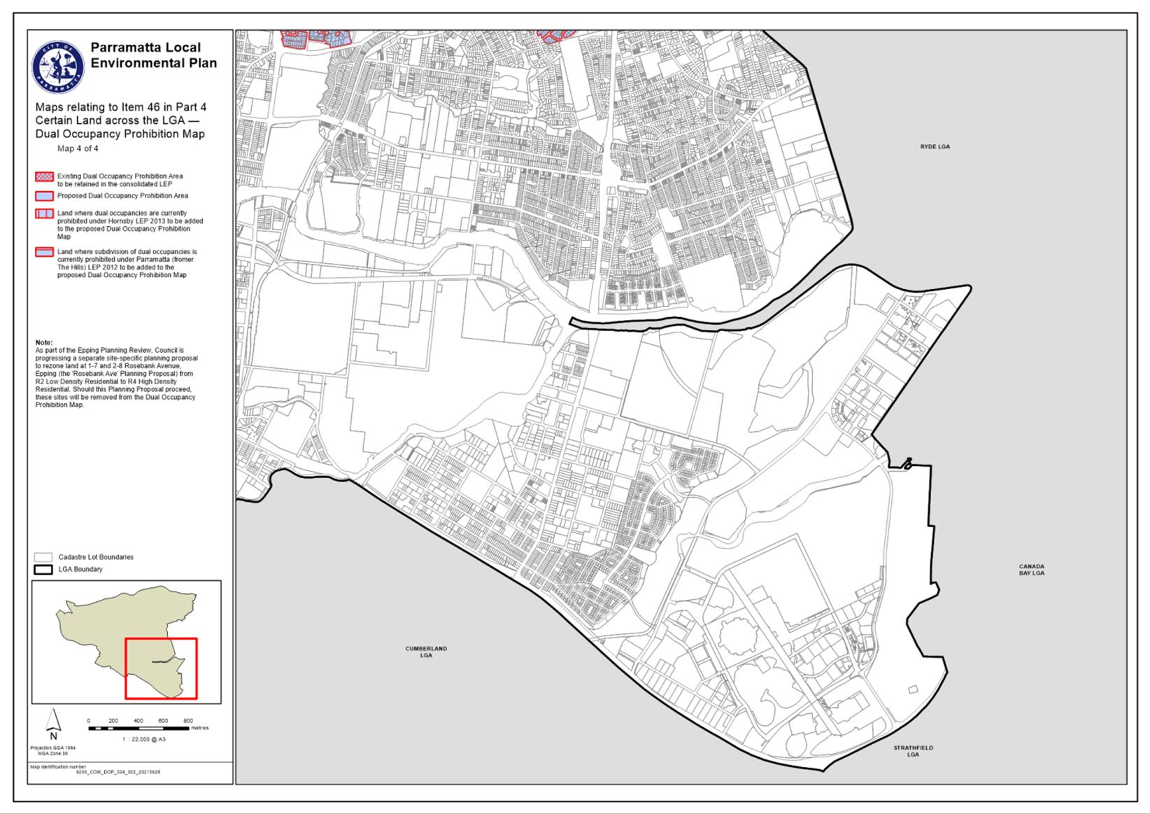
13.1 FOR NOTATION: Variations to Standards under Clause 4.6 of Parramatta LEP 2011, Auburn LEP 2010, Holroyd LEP 2013, The Hills LEP 2012, Hornsby LEP 2013.................... 26
13.2 FOR APPROVAL: Public Exhibition of Alfred Street pedestrian and cyclist upgrade, and T-Way Cycleway re-alignment............................................ 30
13.3 FOR APPROVAL: Reappointment of Alternative Members for the Sydney Central City Planning Panel................ 60
Council 12 July 2021 Item 13.1
ITEM NUMBER 13.1
SUBJECT FOR NOTATION: Variations to Standards under Clause 4.6 of Parramatta LEP 2011, Auburn LEP 2010, Holroyd LEP 2013, The Hills LEP 2012, Hornsby LEP 2013
REFERENCE F2021/00521 - D08097868
REPORT OF Group Manager - Development and Traffic Services
|
PURPOSE:
To provide Council with information each month on development applications determined where there has been a variation in development standards under Clause 4.6 of the Local Environment Plans.
|
|
That the report be received and noted.
|
BACKGROUND
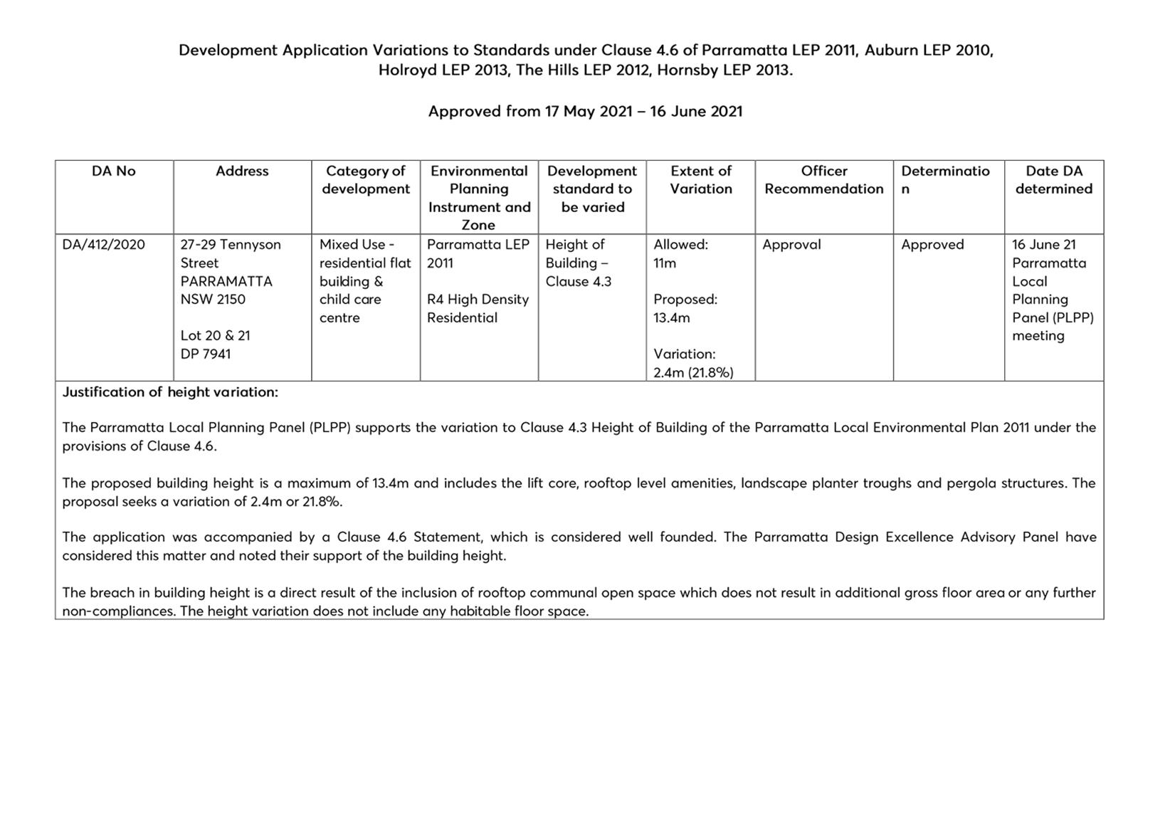
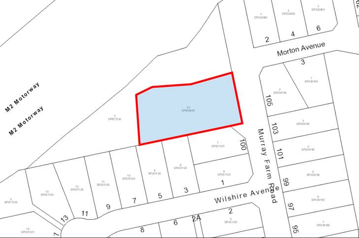
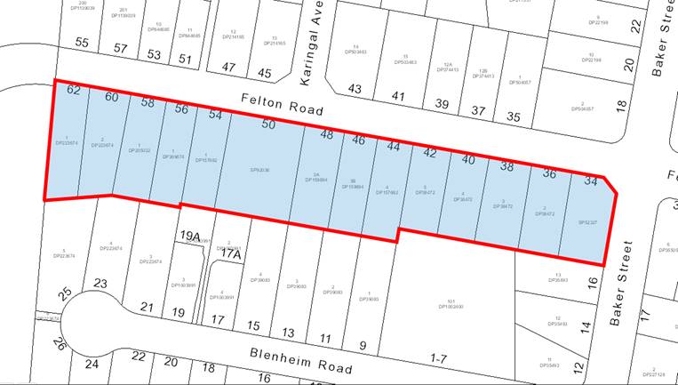
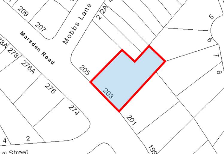
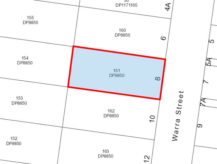
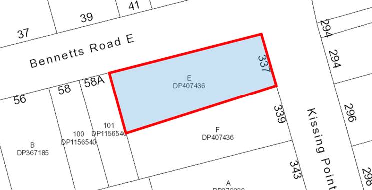
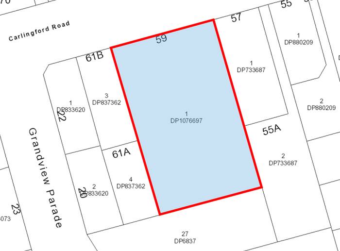
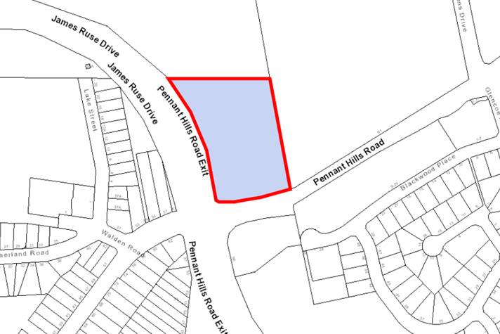
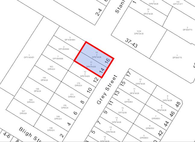
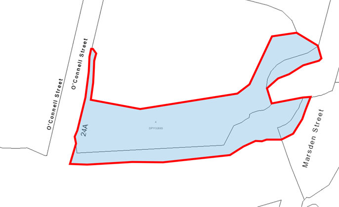
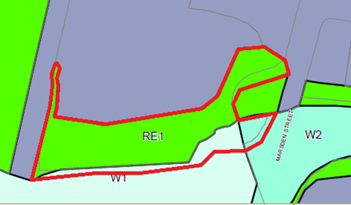
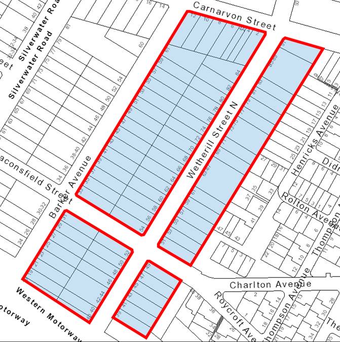
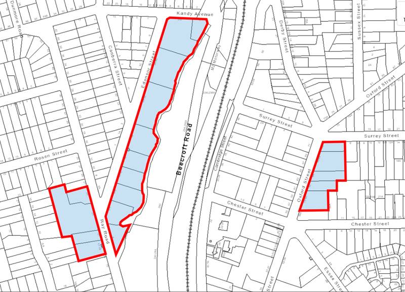
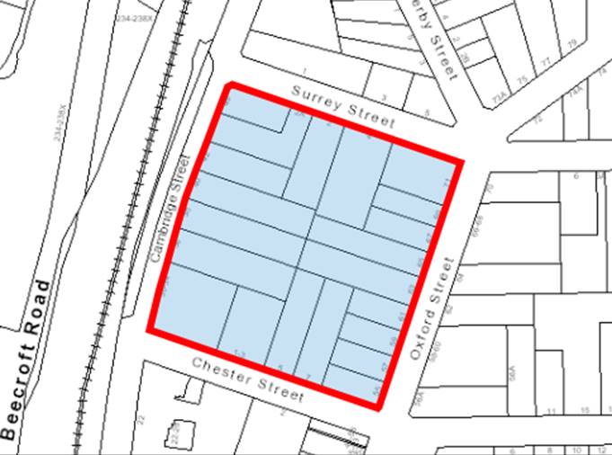
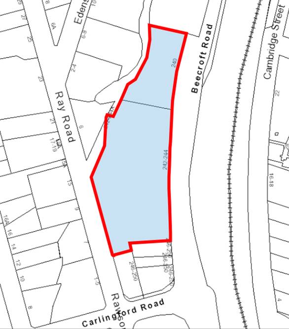
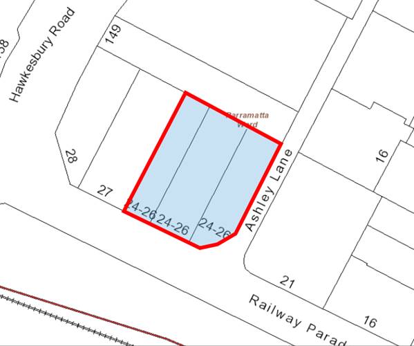
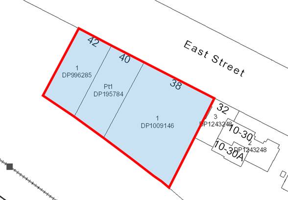
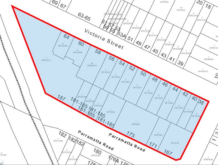
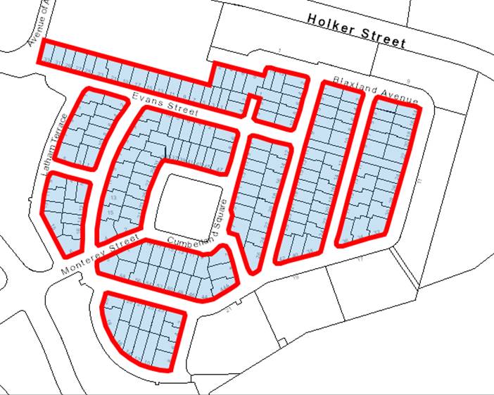
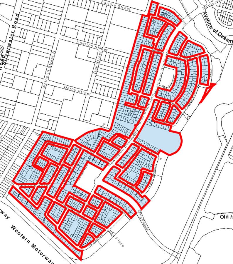
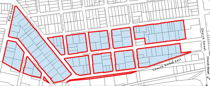
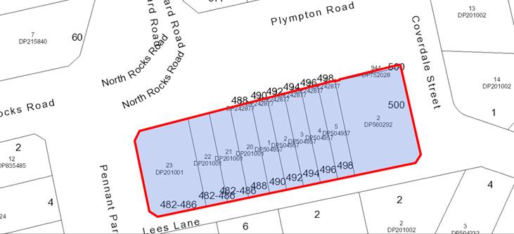
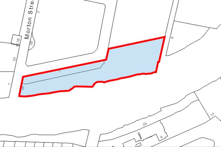
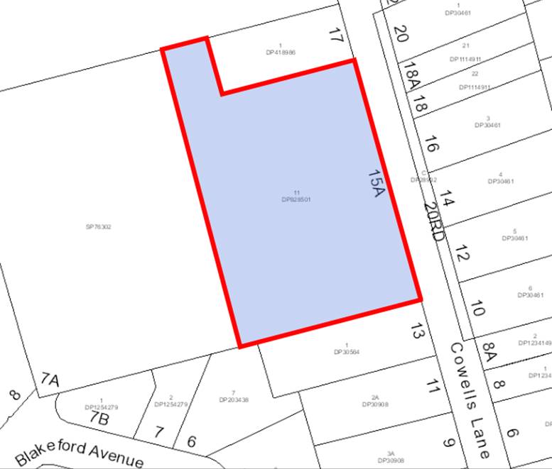
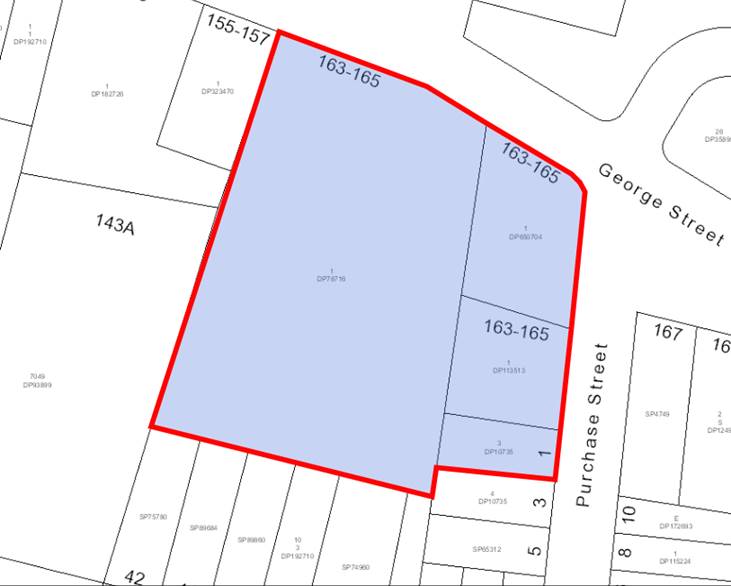
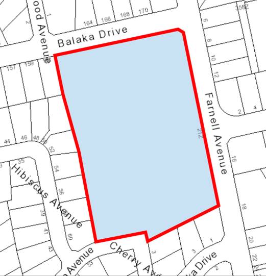
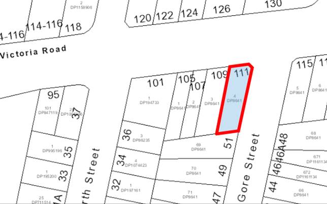
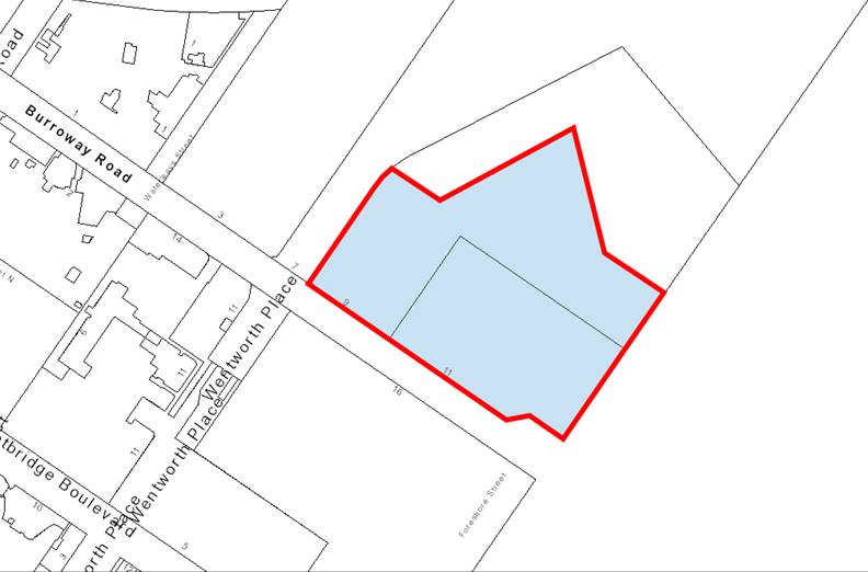
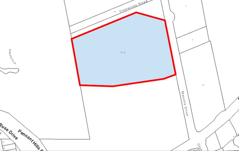
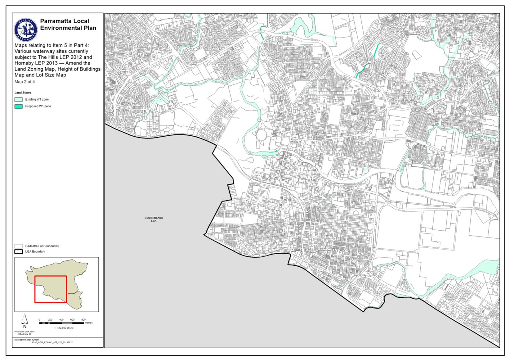
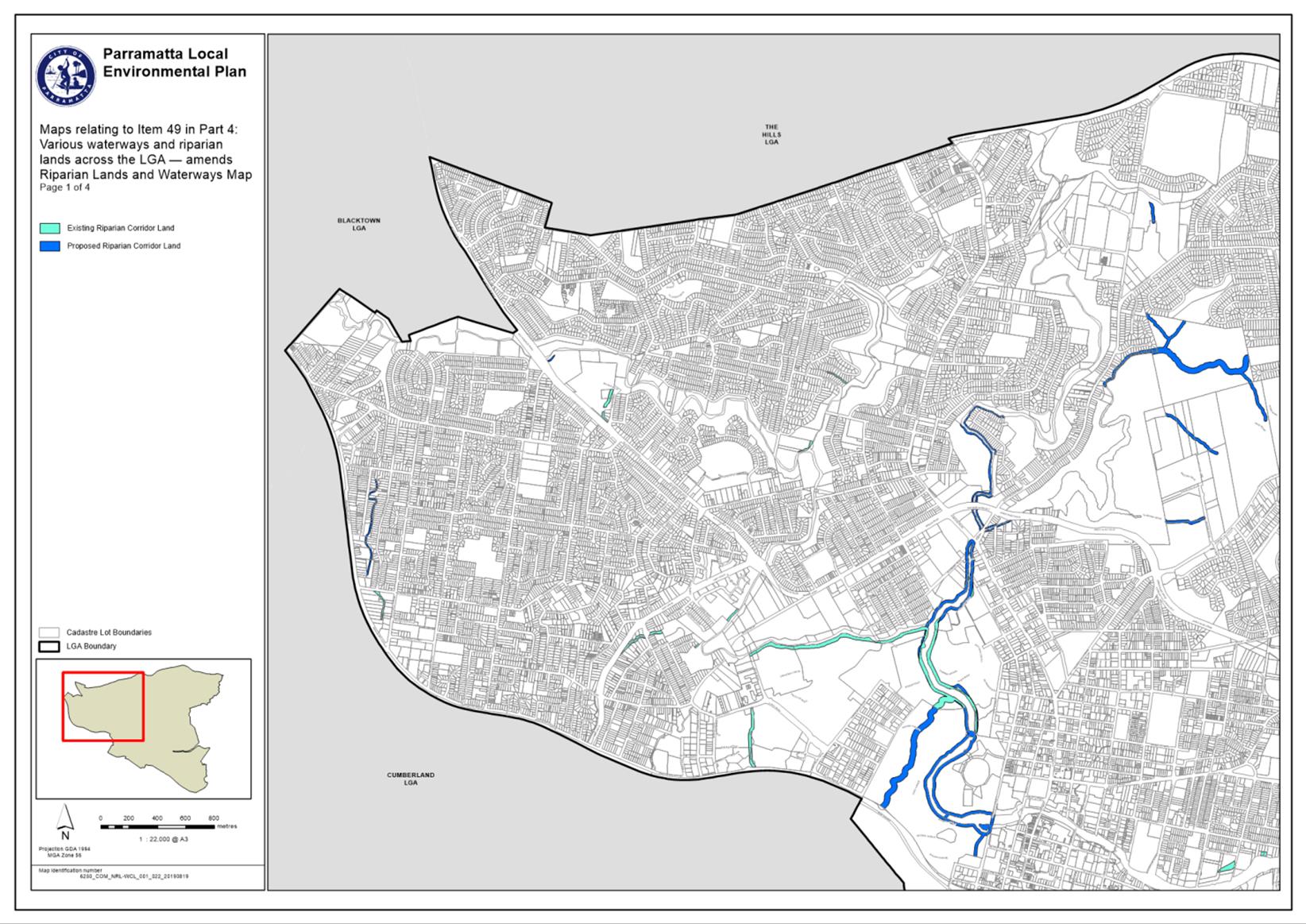
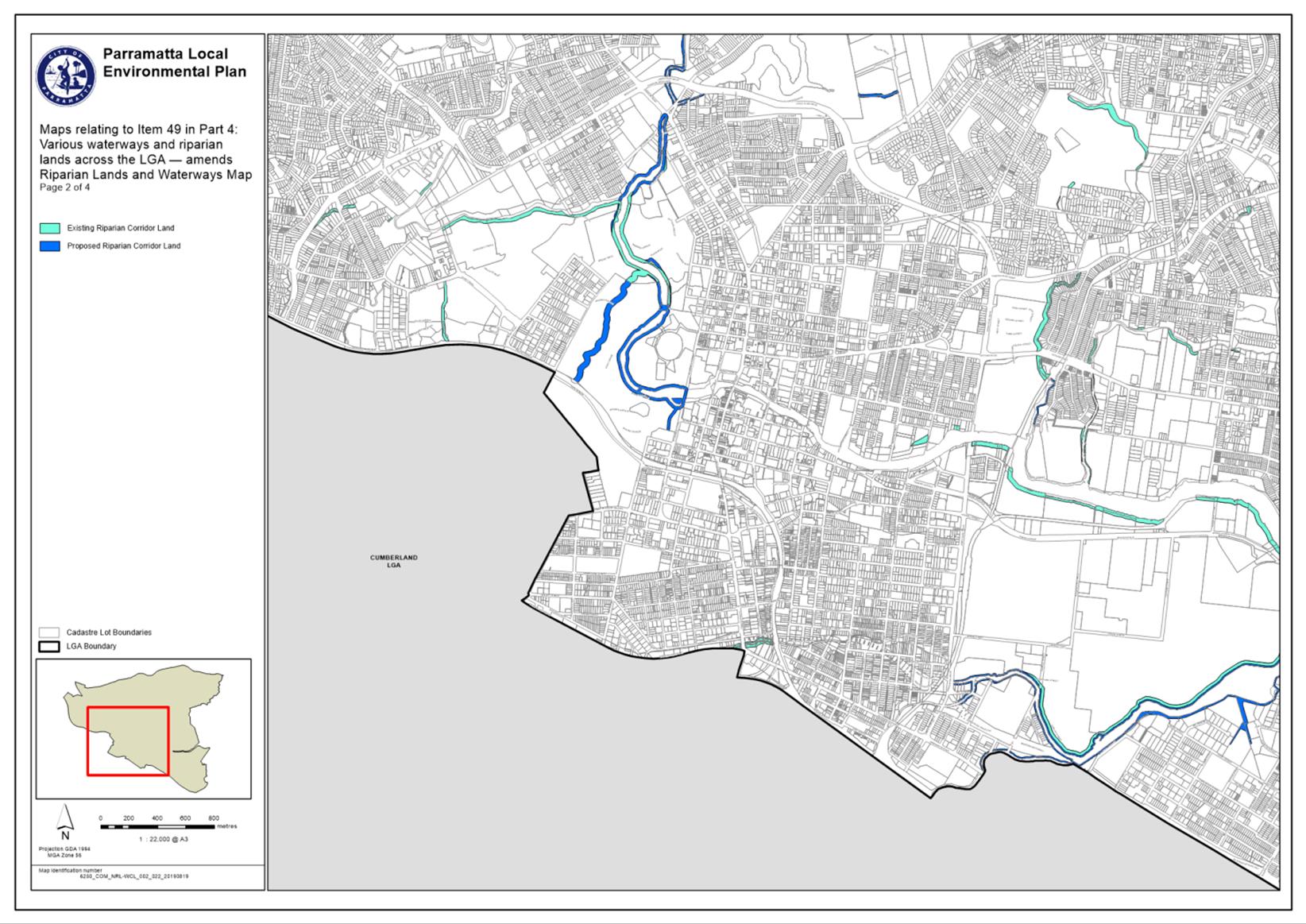
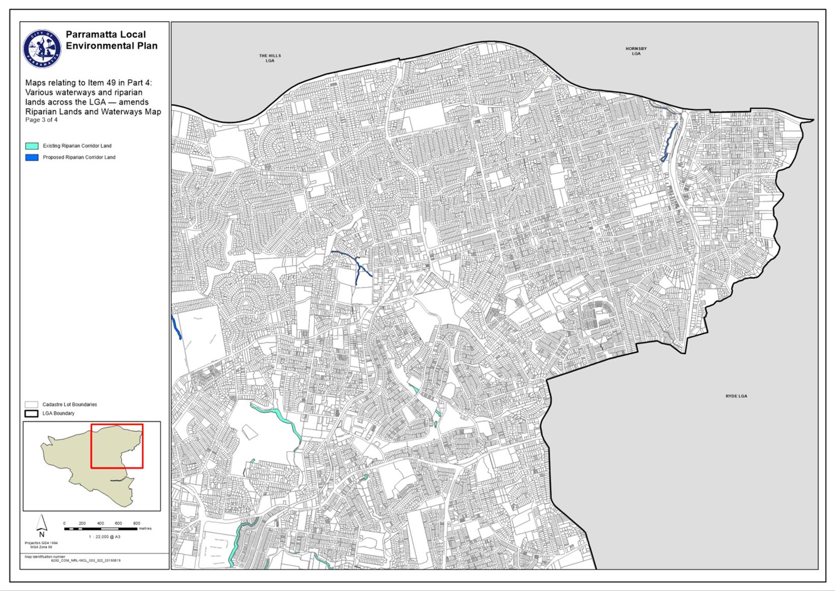
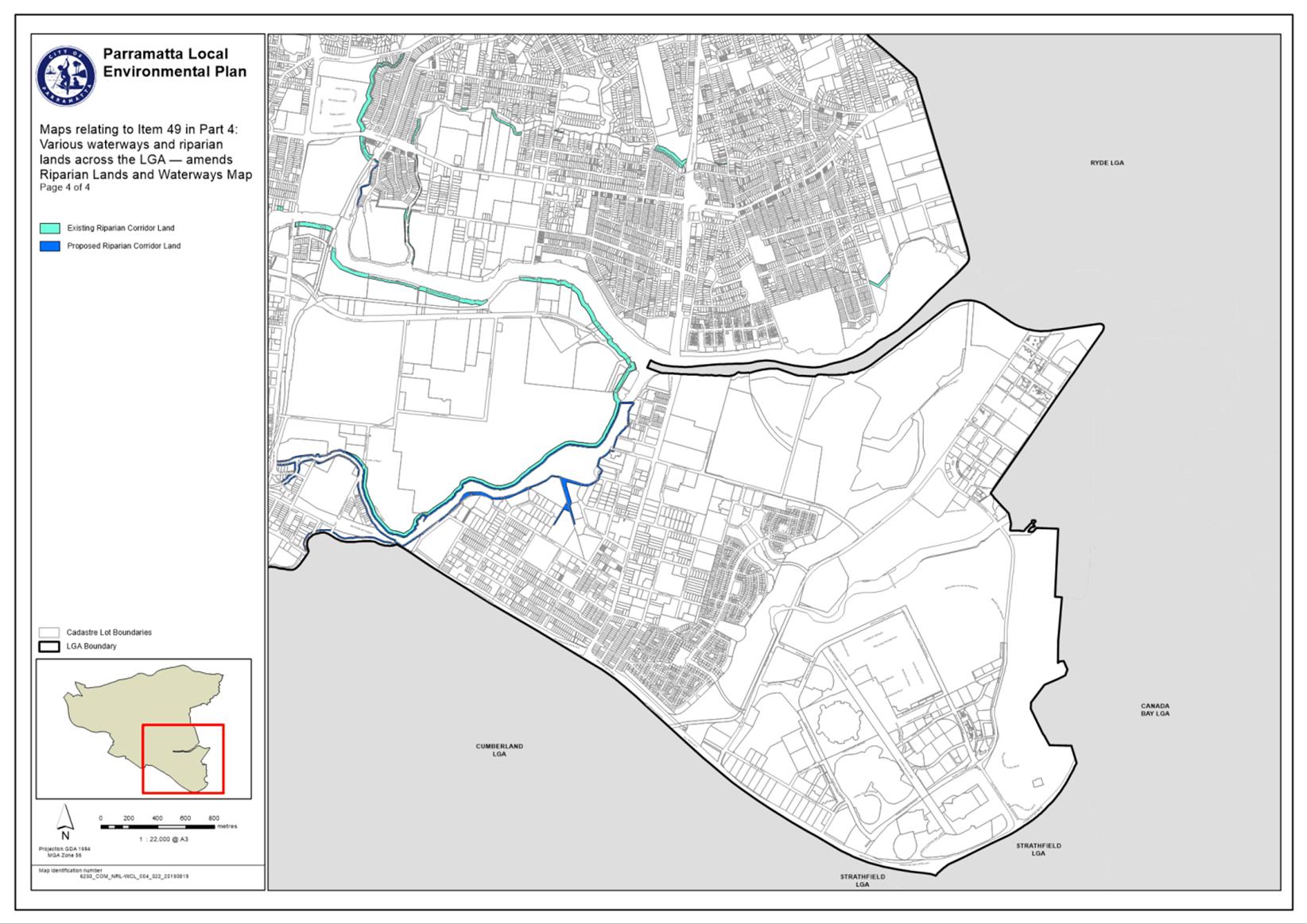
1. During the reporting period 17 May 2021 to 16 June 2021, there was (1) Development Application where there was a variation to a development standard under Clause 4.6. Refer to Attachment 1 for further details.
2. Under Clause 4.6 of the relevant Local Environmental Plan (LEP) applying to the local government area of the City of Parramatta, development consent may be granted for development even though the development would contravene a development standard such as a height and/or floor space ratio standard contained within an LEP.
3. A report is presented to Council each month on any development consent issued where the development does not comply with a development standard. This report follows the reporting requirements prescribed in Planning Circular PS08-014 issued by the (then) NSW Department of Planning.
4. Controls within Development Control Plans (DCPs) are not development standards as a DCP is not an “environmental planning instrument”.
ISSUES/OPTIONS/CONSEQUENCE
5. There are no issues, options or consequence for Council associated with this report.
CONSULTATION & TIMING
6. There are no consultation and timing considerations for Council associated with this report.
Stakeholder Consultation
7. The following stakeholder consultation has been undertaken in relation to this matter:
|
Date |
Stakeholder |
Stakeholder Comment |
Council Officer Response |
Responsibility |
|
N/A |
N/A |
N/A |
N/A |
N/A |
Councillor Consultation
8. The following Councillor consultation has been undertaken in relation to this matter:
|
Date |
Councillor |
Councillor Comment |
Council Officer Response |
Responsibility |
|
N/A |
N/A |
N/A |
N/A |
N/A |
LEGAL IMPLICATIONS FOR COUNCIL
9. There are no legal implications for Council associated with this report.
FINANCIAL IMPLICATIONS FOR COUNCIL
10. There are no financial implications for Council associated with this report.
|
|
FY 20/21 |
FY 21/22 |
FY 22/23 |
FY 23/24 |
|
Operating Result |
|
|
|
|
|
External Costs |
|
|
|
|
|
Internal Costs |
|
|
|
|
|
Depreciation |
|
|
|
|
|
Other |
|
|
|
|
|
Total Operating Result |
Nil |
|
|
|
|
|
|
|
|
|
|
Funding Source |
NA |
|
|
|
|
|
|
|
|
|
|
CAPEX |
|
|
|
|
|
CAPEX |
|
|
|
|
|
External |
|
|
|
|
|
Internal |
|
|
|
|
|
Other |
|
|
|
|
|
Total CAPEX |
Nil |
|
|
|
|
|
|
|
|
|
|
Funding Source |
NA |
|
|
|
Mark Leotta
Group Manager Development and Traffic Services
Michael Tzimoulas
Executive Director, Corporate Services
David Birds
A/Executive Director City Planning & Design
Brett Newman
Chief Executive Officer
|
1⇩ |
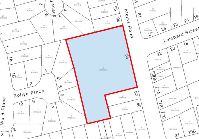
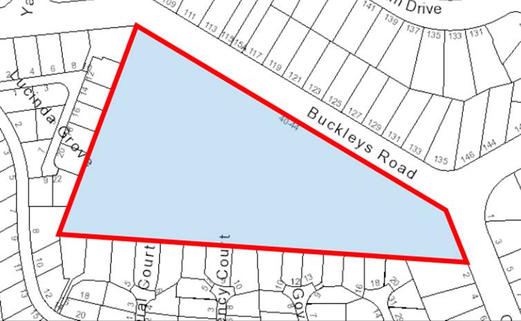
Development Application Variations under SEPP 1 - 17 May - 16 June 2021 |
1 Page |
|
Council 12 July 2021 Item 13.2
ITEM NUMBER 13.2
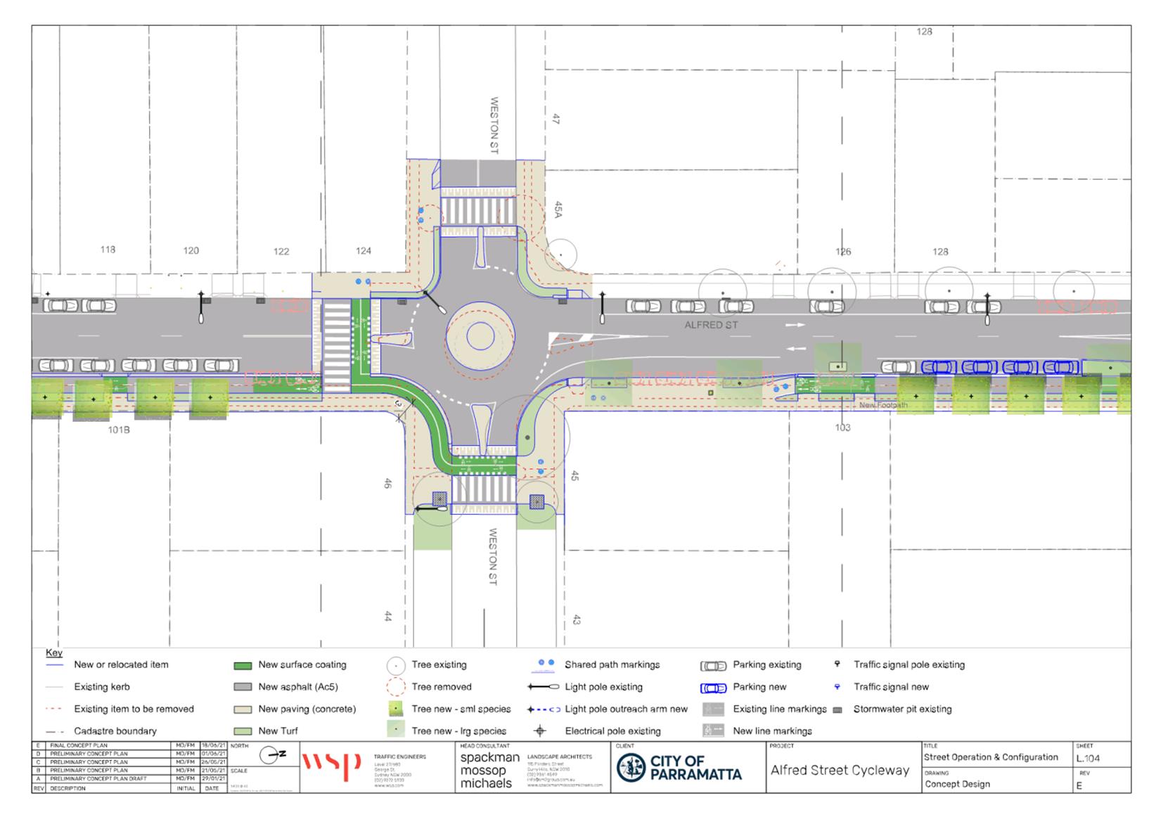
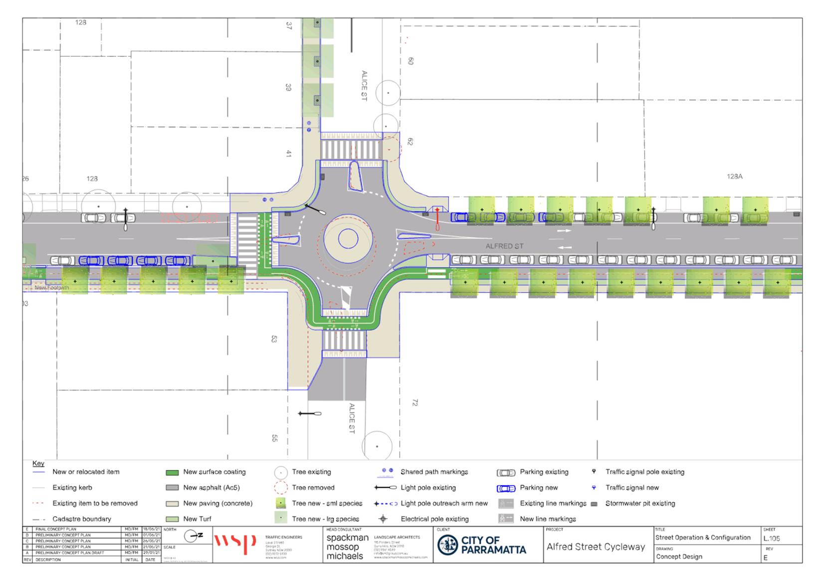
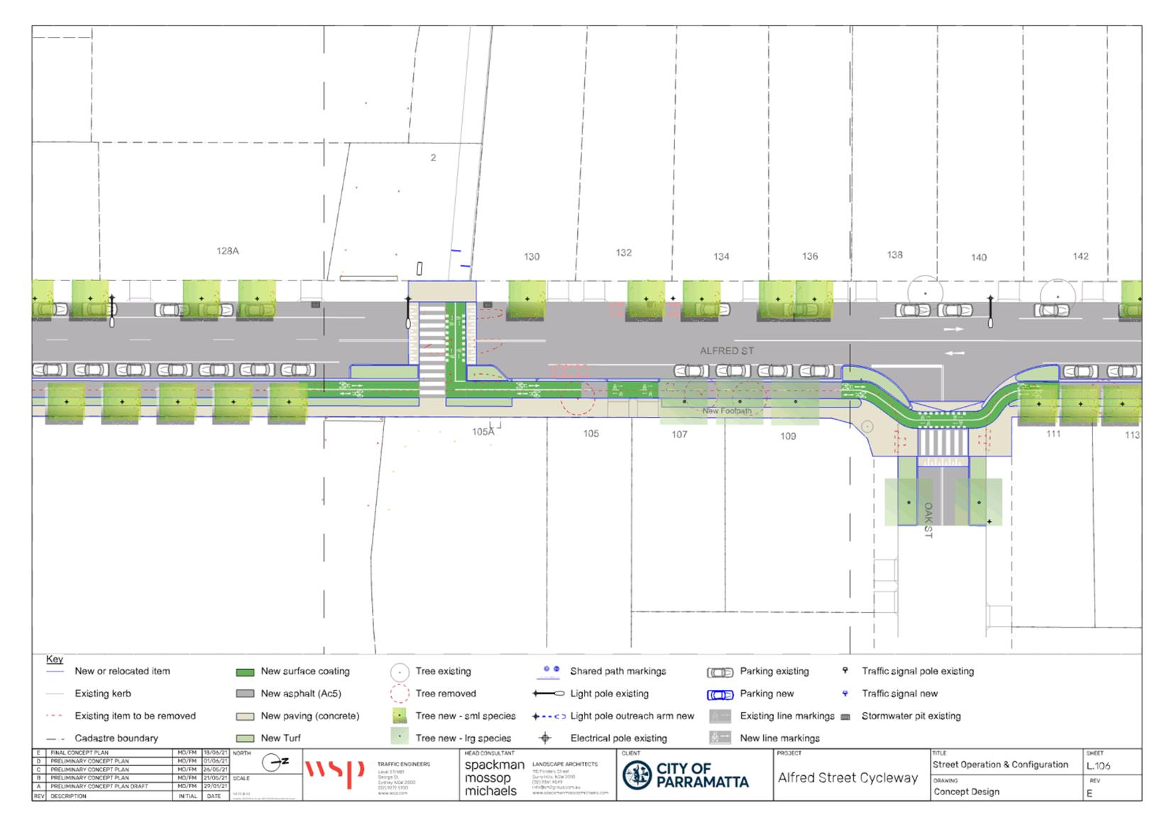
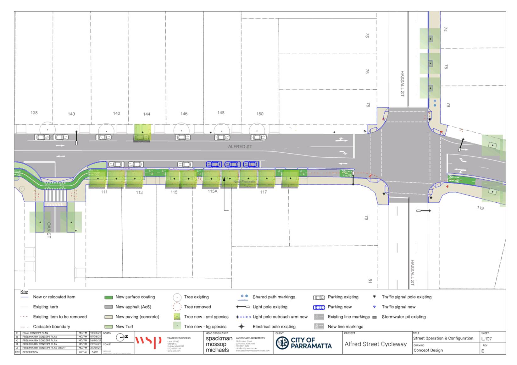
SUBJECT FOR APPROVAL: Public Exhibition of Alfred Street pedestrian and cyclist upgrade, and T-Way Cycleway re-alignment
REFERENCE F2021/00521 - D08096302
REPORT OF Senior Project Officer Transport Planning
workshop/briefing date: Parramatta Ward Councillor briefing on T-Way Cycleway re-alignment 20 May 2021, Rosehill Ward Councillor briefing on Alfred Street pedestrian and cyclist upgrade 2 June 2021.
PURPOSE:
This report seeks the endorsement of Council to publicly exhibit both the Alfred Street pedestrian and cyclist upgrade, as well as the T-Way Cycleway re-alignment.
(a) That Council approve the attached draft Alfred Street pedestrian and cyclist upgrade at Attachment 1 and Attachment 2 for the purposes of exhibition.
(b) That Council approve the attached draft T-Way Cycleway re-alignment at Attachment 3, for the purposes of exhibition.
(c) That the draft plans be placed on exhibition for a minimum period of 28 days.
(d) Further, that the outcomes of public exhibition of the plans be reported to Parramatta Traffic Committee, and in turn to Council.
BACKGROUND
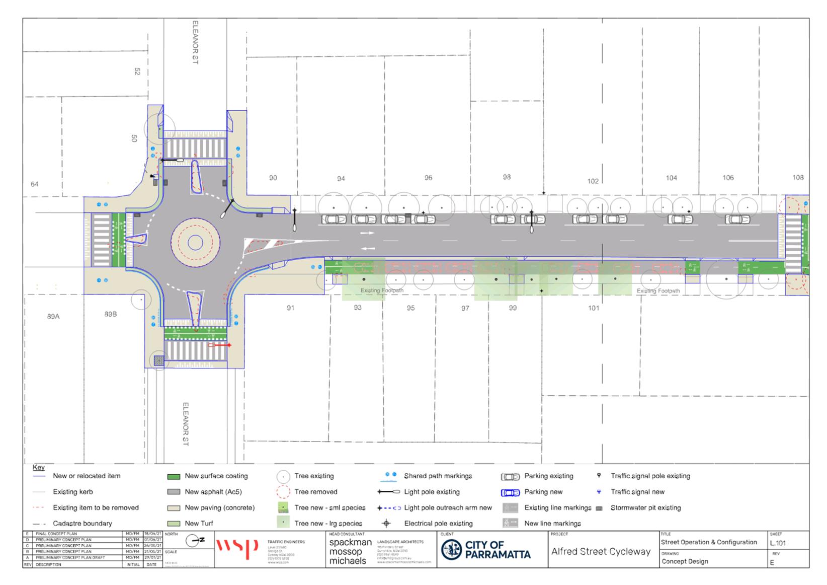
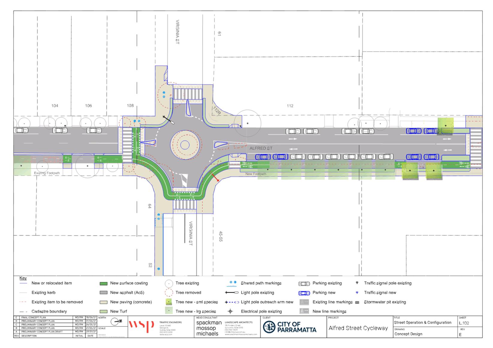
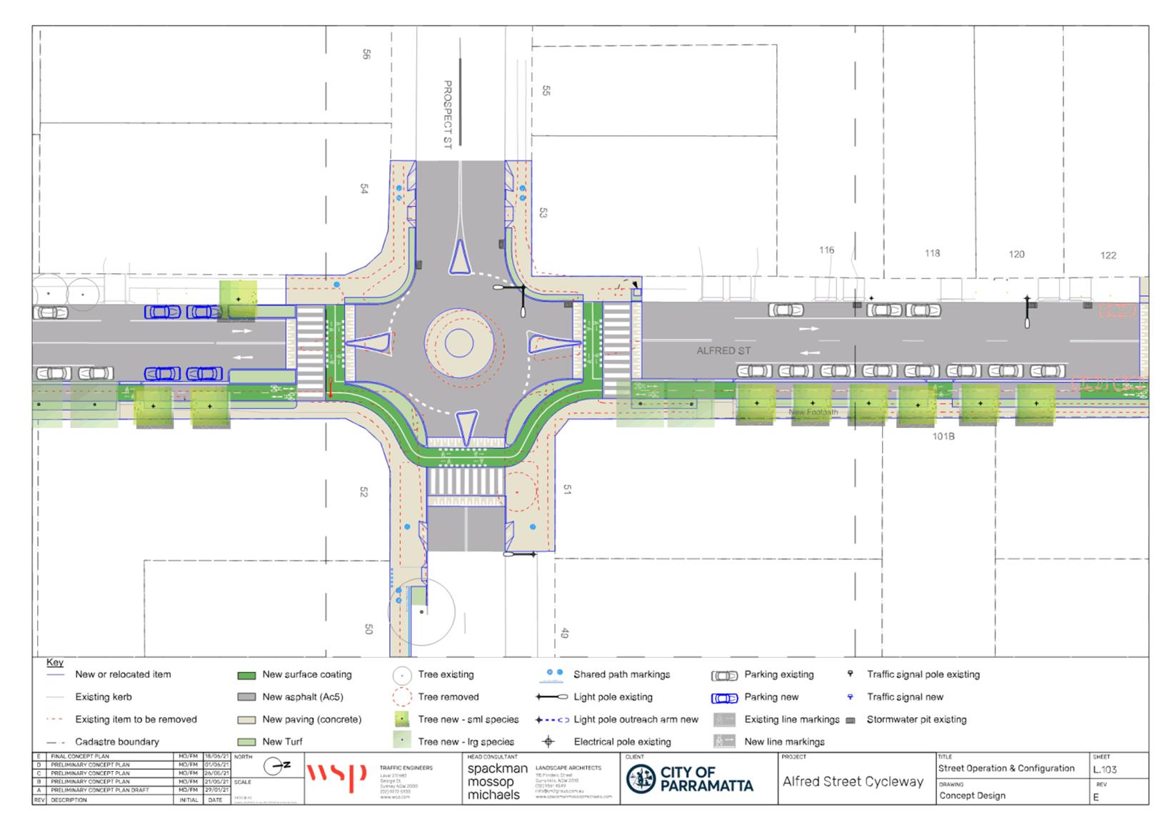
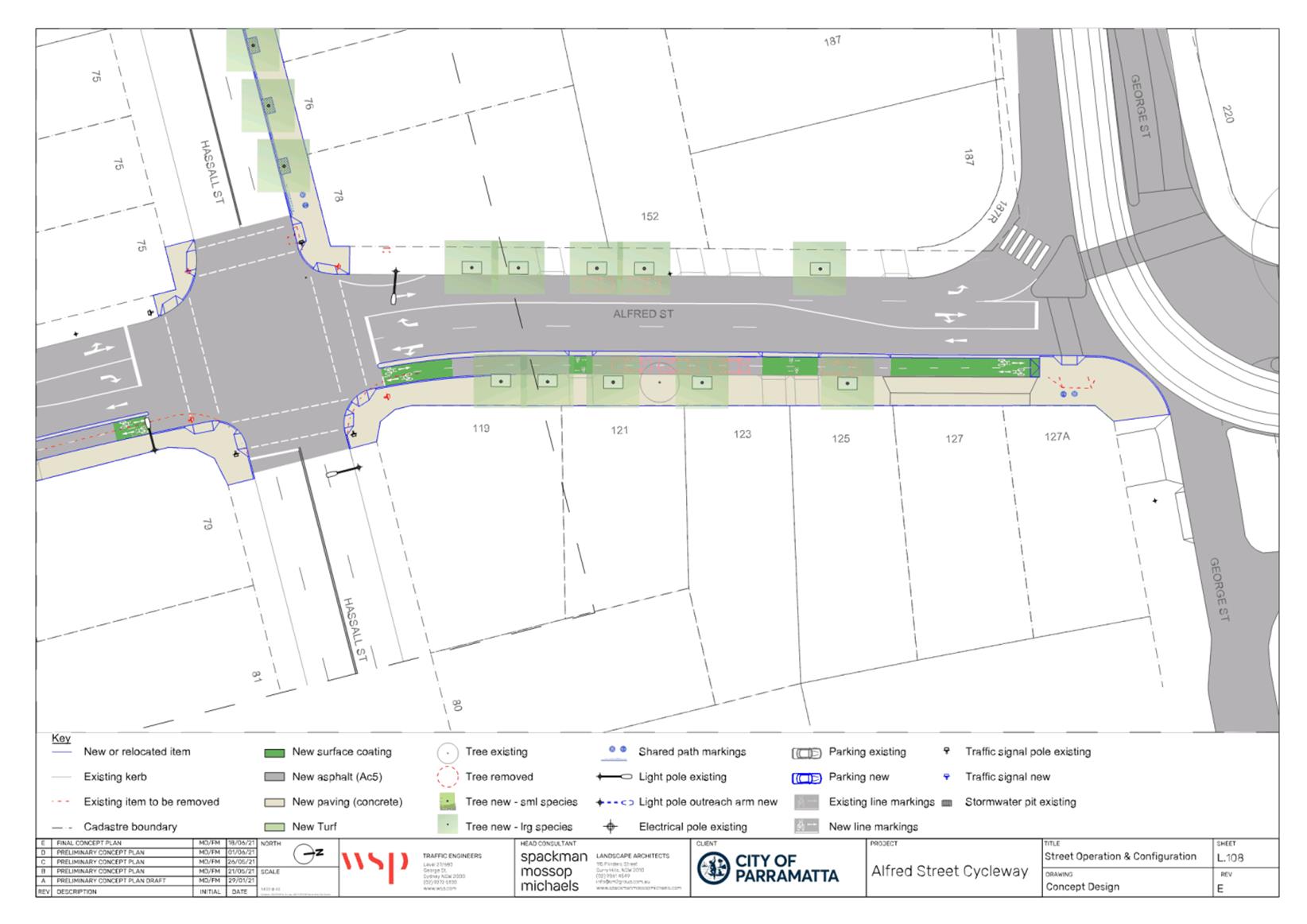
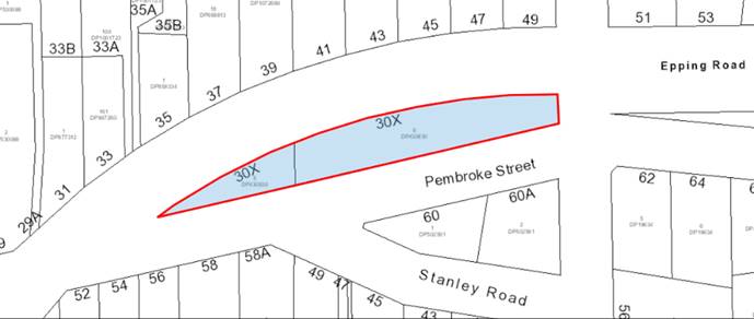
1. Alfred Street in Harris Park is identified in Transport for NSW's (TfNSW) Principle Bicycle Network (PBN), and as a high priority separated cycleway in Council’s endorsed Bike Plan. It is also identified as a key pedestrian street in the Parramatta Ways strategy. The staged delivery of pedestrian and cyclist improvements along Alfred Street are currently being delivered in multiple stages (as per Figure 1):
A. Southern foreshore path from Alfred St to the CBD through Queens Wharf Reserve (funded by Council for design next FY).
B. Alfred St Bridge over the Parramatta River (co-funded by Council and NSW Government for construction).
C. Eleanor Street to George Street (this project).
D. Eleanor Street to Gray Street (funded by NSW Government) and connection to Jordan St (funded by Federal Government) for construction.
E. Gray Street to Parramatta Road as part of FS Garside upgrade (funded by NSW Government for construction).
F. New pedestrian and cyclist crossing over Parramatta Road at Marsh Street with connecting shared paths (funded by NSW Government for construction).
![]()
![]()
![]()
![]()
![]()
![]()
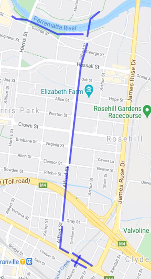
Figure 1: Alfred Street Stages
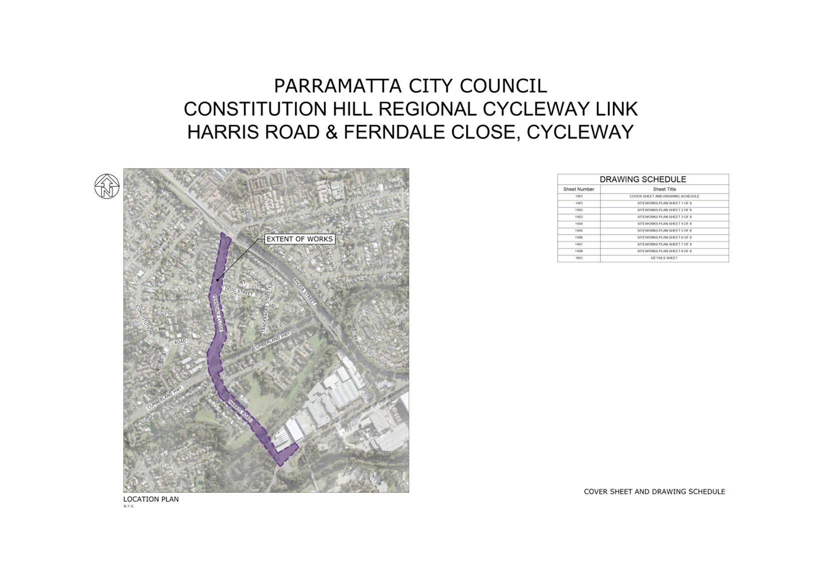
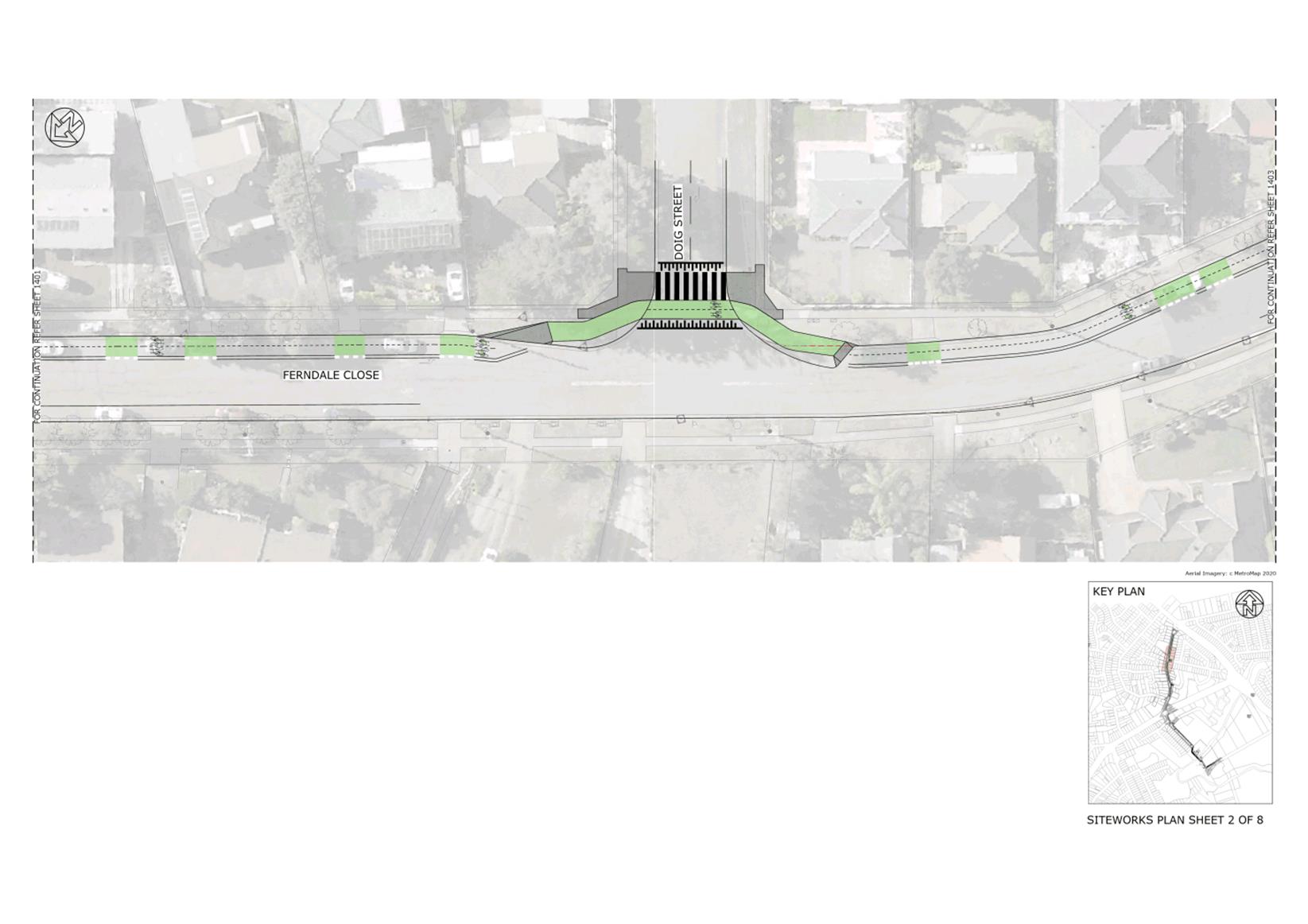
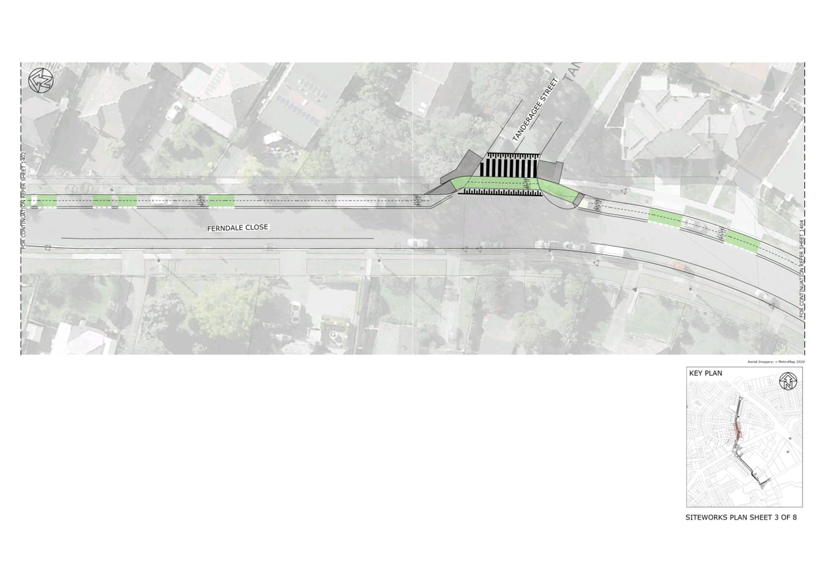
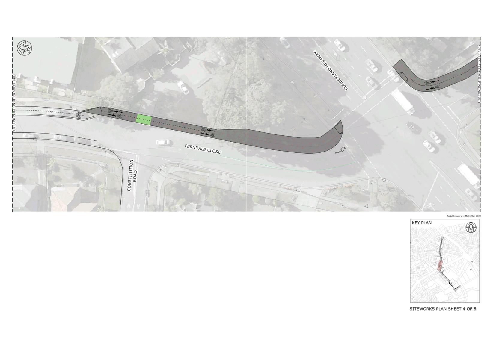
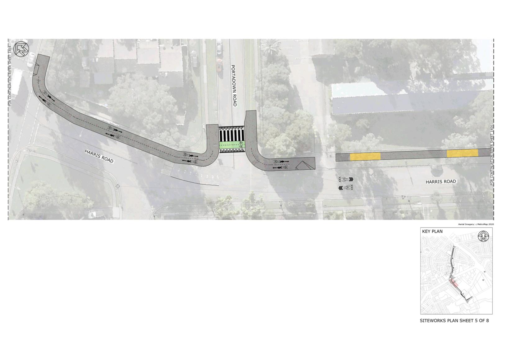
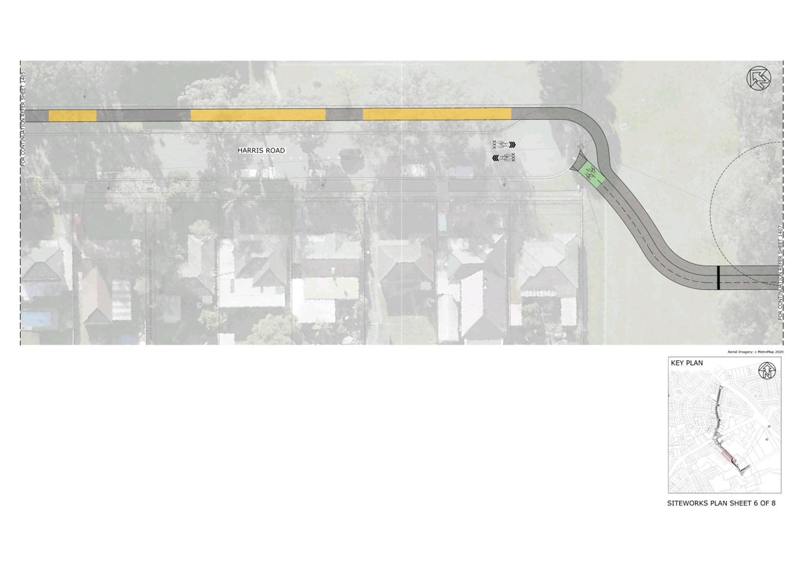
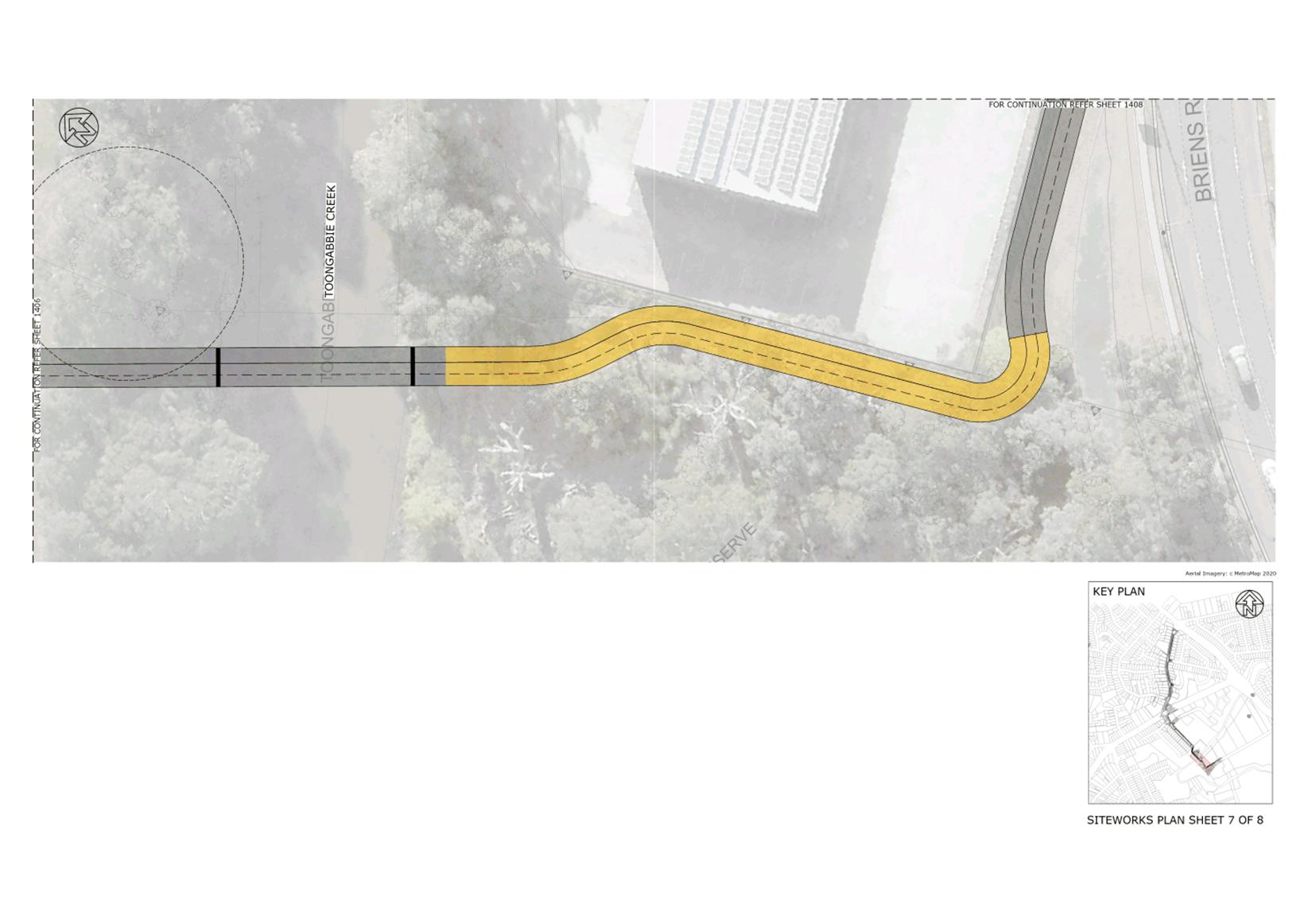
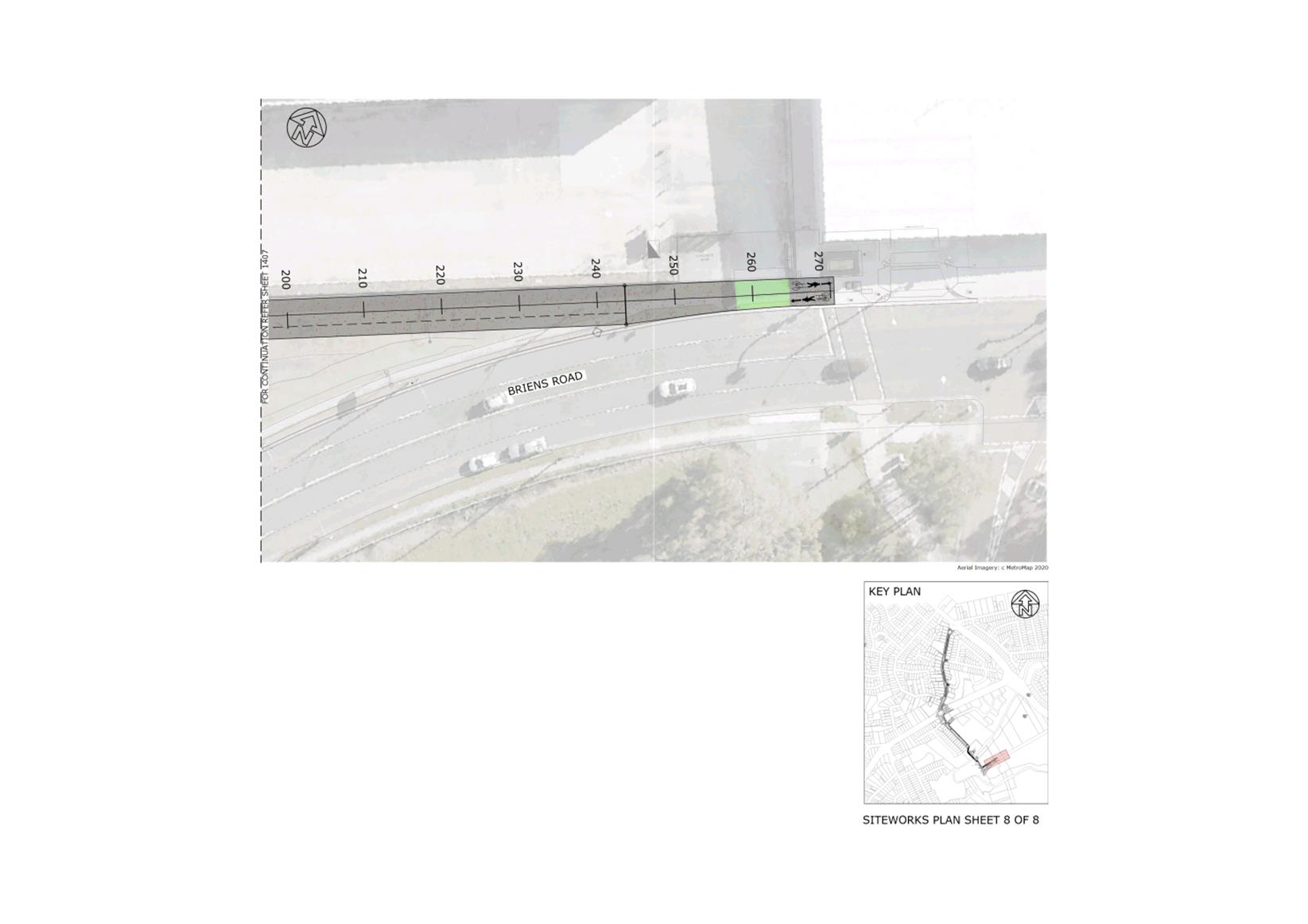
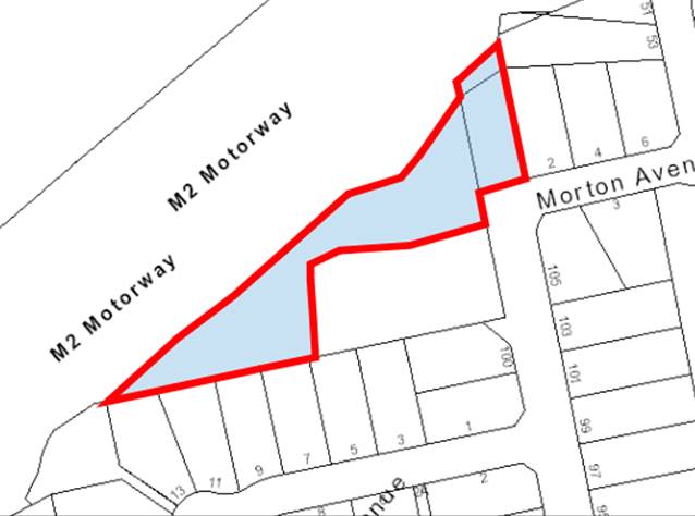
2. The T-Way Cycleway is a 30 km off-road path from Windsor to Parramatta of which only 4 on road sections remain, all within City of Parramatta (as per Figure 2). The current path hosts around 4,000 cyclists per month, but requires cyclists to cross the Cumberland Hwy in three stages and has a concentration of cyclist crashes along the northern side of Briens Road due a significant number of commercial driveways (as per Figure 3).
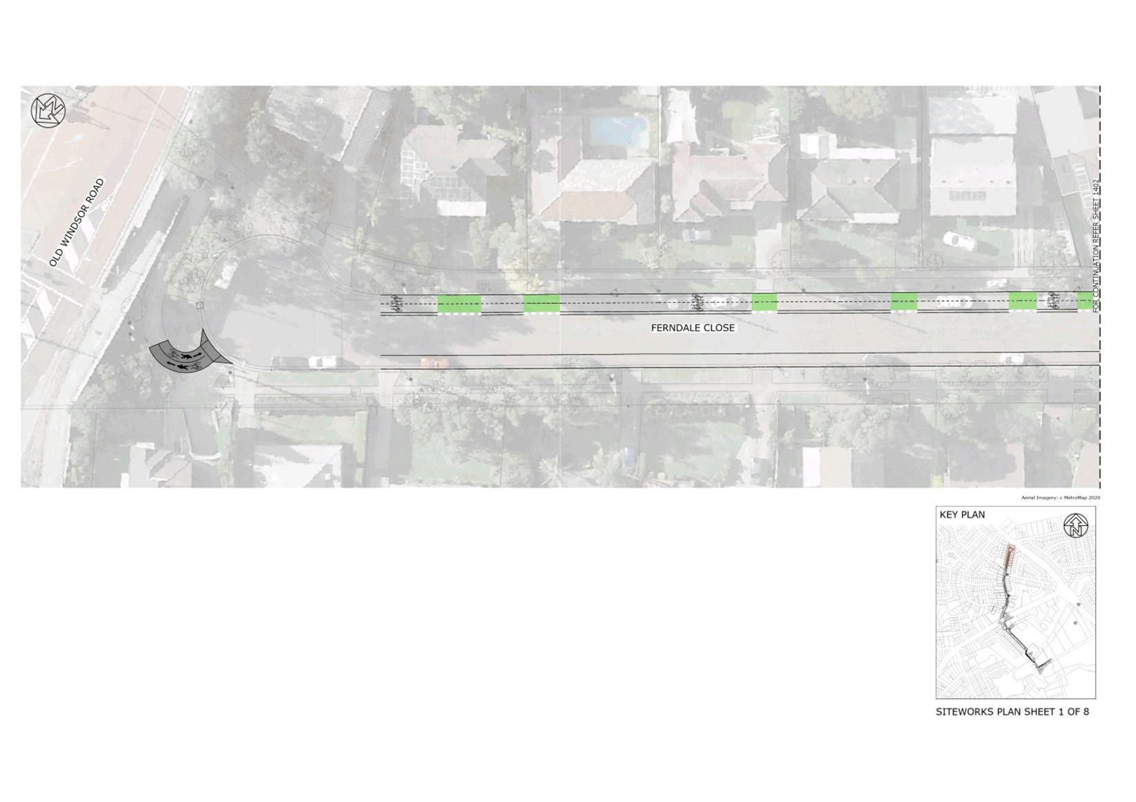
3. A re-alignment is proposed that:
A. Separates cyclists and traffic,
B. Separates cyclists and pedestrians where space allows,
C. Provides a single stage crossing of Cumberland Hwy,
D. Provides a direct connection to Toongabbie East Public School,
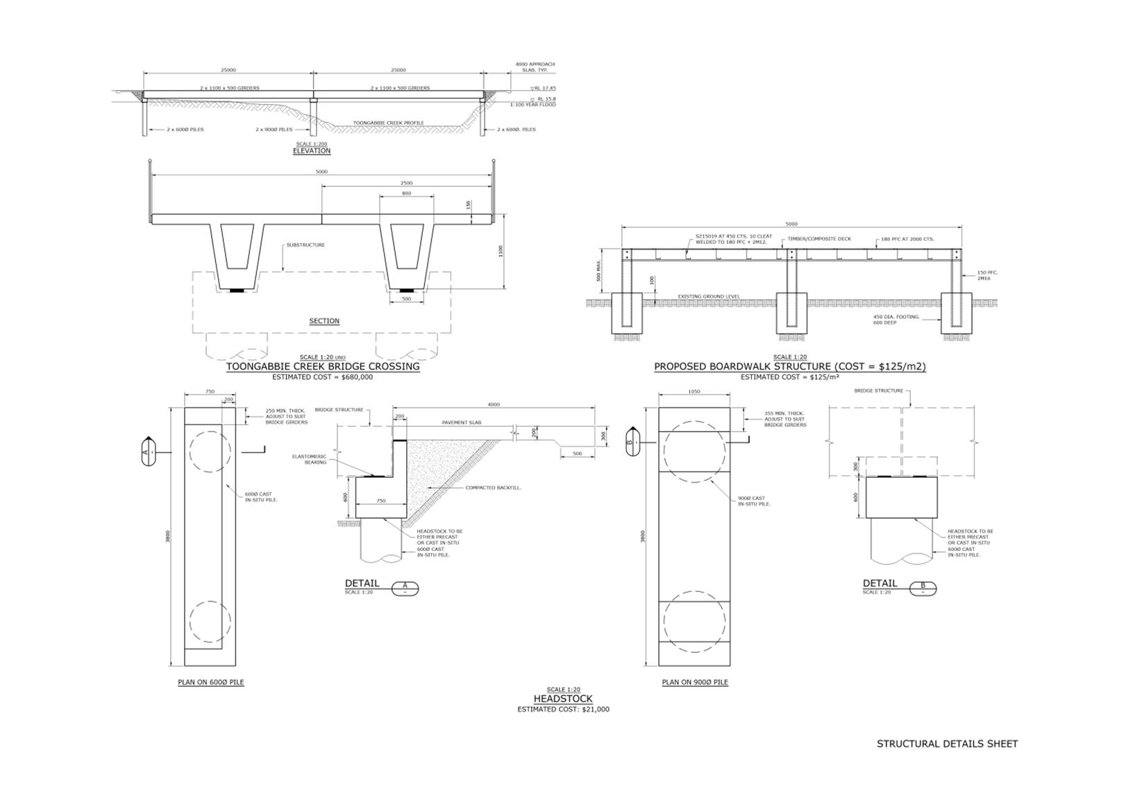
E. Provides a new bridge over Toongabbie creek (800m shorter than existing routes),
F. Reduces steep climbs,
G. Eliminates commercial driveway crossings.
![]()
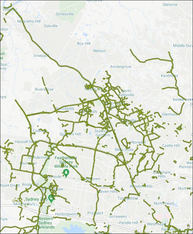
Figure 2: T-Way Cycleway (regional)
![]()
![]()
![]()
![]()
![]()
![]()
![]()
![]()
![]()
![]()
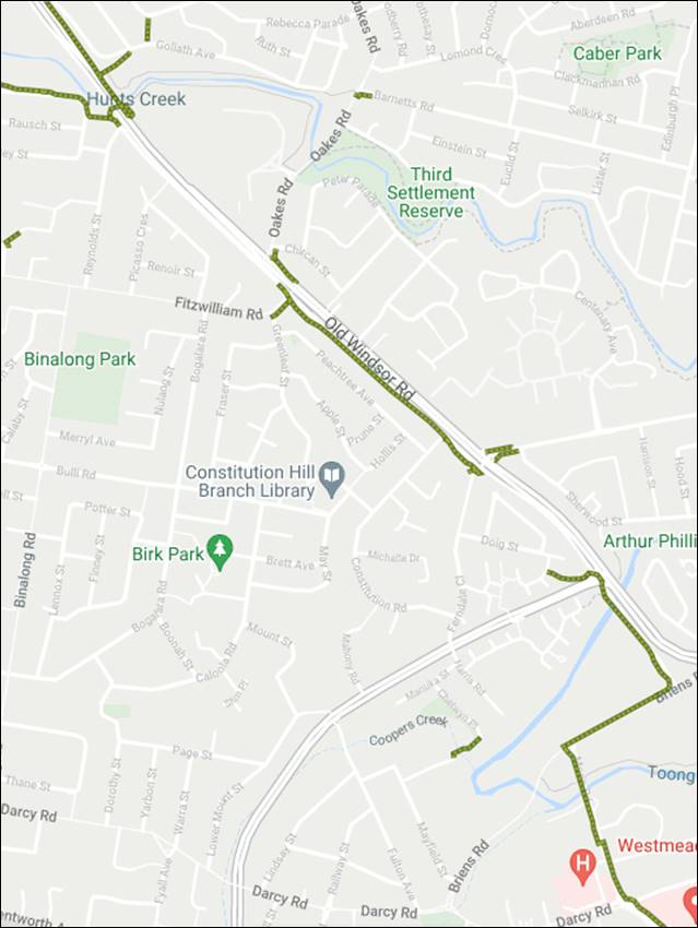
Figure 3: T-Way Cycleway (local)
4. TfNSW has provided a letter of intent to Council, should suitable designs be prepared, consulted with the community and approved both projects would be eligible for construction funding through the NSW Government's Active Transport Program for the 2021/22 financial year.
ISSUES/OPTIONS/CONSEQUENCES
5. The Alfred Street Pedestrian and Cyclist Upgrade at Attachment 1 would result in a higher quality, safer, pedestrian and cyclist experience along and across a key regional link between Granville and the Parramatta River. Once the stages outlined in 1B to 1E are completed, there will be a mostly separated cycleway from Parramatta Road to the northern bank of the Parramatta River via the M4 Cycleway, giving workers, residents and visitors opportunities to safely get out and active.
6. The draft concept plans identify 18 street trees that will be removed as part of the project, however this is only where there is no alternative. Eighty-six potential locations have been identified on the eastern and western side of Alfred Street to provide a local tree offset.
7. A number of on-street car parking spaces will need to be removed for the project to be constructed, however parking surveys demonstrate that the maximum occupancy for parking on Alfred Street is approximately 80 spaces. The current draft plans retain approximately 80-85 spaces on Alfred Street itself, with additional capacity identified on a number of side streets. All dwellings (houses and units) fronting Alfred Street have access to off-street car parking, the exception being three houses on the eastern side of Alfred Street near Eleanor Street.
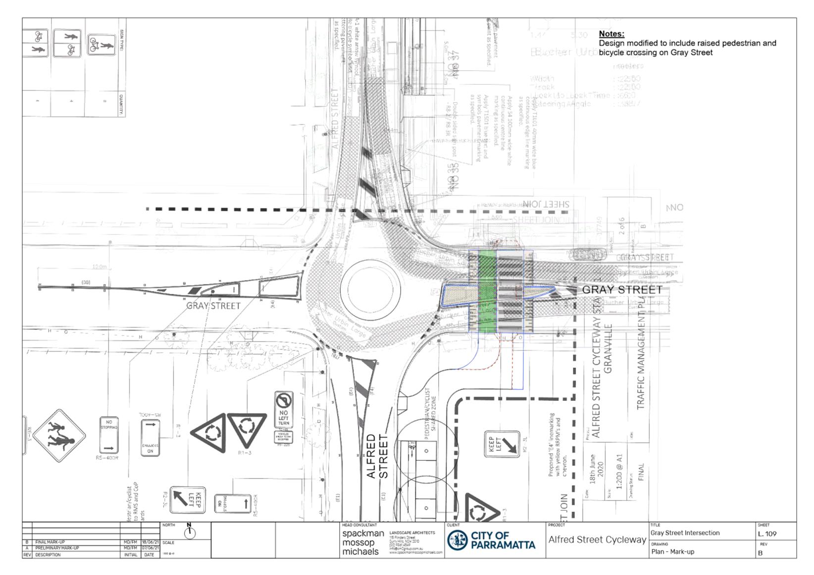
8. The intersection of Gray Street and Alfred Street at Attachment 2 is being re-exhibited (originally exhibited in 2020) as the eastern leg has recently been updated to a priority pedestrian and cyclist crossing (from a refuge island) in line with the update to priority crossing warrants in Parramatta.
9. On the eastern side of Alfred Street adjacent to No45 Weston Street is a heritage listed boundary stone dated 1839, one of a number in Parramatta that defined the edge of Parramatta. A heritage assessment will be conducted in parallel with detail design into its heritage value, whether it is in its original location, and how to protect it.
10. The T-way re-alignment at Attachment 3 would result in a greater degree of separation, and a safer, shorter, easier, and more enjoyable route for both cyclists and pedestrians on a key regional route.
11. A number of trees within the Council owned reserve south of Toongabbie Creek will be impacted, however informed by expert advice, the alignment avoids and protects highest value trees.
12. Due to the narrow width of Ferndale Close it is not possible to retain parking on both sides north of Constitution Road and have a separated cycleway. On Ferndale close there are approximately 120 parking spots of which approximately 60 would need to be removed for the project. Parking surveys demonstrate the average occupancy is 40 spaces, and peak usage is just over 50 spaces. All houses in Ferndale Close have access to 1 or more off-street car parking spots. The parking survey demonstrates that once the project is implemented there will still be an available surplus of street parking on Ferndale Close, and adjacent streets.
13. Toongabbie East Public School is a key stakeholder in two elements, crossings of Portadown Road and the shared path on Harris Road. The proposed pedestrian and cyclist priority crossing over Portadown Road is 60m from the existing pedestrian only crossing, should the latter crossing need to be moved or removed as a result of consultation, any change would require exhibition. The shared path on Harris Road is constrained by the school fence and not impacting the large trees on the eastern verge. Should the school agree to move the fence and grant a licence or easement to Council as a result of the consultation, this path could be widened to 3m to provide a more generous width.
14. Both projects already have internally approved funding for design. As per the Letter of Intent provided at Attachment 4, should both projects be consulted, approved and meet the criteria of Transport for NSW, they are both eligible for 100% State Government design and construction funding in the 2021/22 financial year.
CONSULTATION & TIMING
Stakeholder Consultation
15. The following stakeholder consultation has been undertaken in relation to this matter:
|
Date |
Stakeholder |
Stakeholder Comment |
Council Officer Response |
Respons-ibility |
|
25 May 2021 |
Cycleways Advisory Committee (both projects) |
Is a link being provided to the Jordan St community Garden (Alfred Street)
Does the proposal affect bus stops (Alfred Street) |
Jordan St connection is included in Stage 1
Bus stops are proposed to be consolidated and the path shared in those locations (as per Stage 1). |
City Strategy |
|
6-11 June 2021 |
Transdev (Alfred Street only) |
Prefer bus stops on Alfred Street to be ‘paired’ to ensure legible network for customers.
Concerns about 3.2m travel lane being adequate. |
Bus stop locations modified to retain ‘paired’ stops.
When considered with parking lane that is larger than the minimum, it exceeds the NSW Bus Infrastructure Guidelines and the overall cross-section matches that approved in Stage 1 of Alfred St immediately south. |
City Strategy |
|
17 June 2021 |
Heritage Advisory Committee (Alfred Street only) |
A heritage assessment of the boundary stone should be conducted, including its heritage value, condition, and future conservation, to inform its consideration within the project. |
An assessment will be undertaken alongside the detail design. |
City Strategy |
Councillor Consultation
16. The following Councillor consultation has been undertaken in relation to this matter:
|
Date |
Councillor |
Councillor Comment |
Council Officer Response |
Responsibility |
|
20 May 2021 |
Parramatta Ward Clrs |
Important that community is consulted regarding parking in Ferndale Close with accurate information
Support taking the cycleway off the main road
Does Harris Road just require an easement with School
Do not want to lose any road space on Mons/Briens Road |
The community will be consulted with the proposal of all parking removed from eastern side north of Constitution Road.
Noted
Correct, just interface with school.
No road space (kerb to kerb) will be re-allocated on Mons/Briens Road. |
City Strategy |
|
2 June 2021 Alfred Street |
Rosehill Ward Clrs |
Concerns about loss of parking
Turning movements will be challenging at service station at northern end
Concerns about loss of trees and the replacement species |
Parking surveys show approximately 80 spaces are used currently, proposing to retain approximately that number of Alfred St, additional parking available on side streets.
Noted, truck access to service station will be a focus.
Trees are only removed as a last resort, will be offset locally and with an appropriate species. |
|
LEGAL IMPLICATIONS FOR COUNCIL
17. There are no legal implications for Council in publicly exhibiting these draft plans.
FINANCIAL IMPLICATIONS FOR COUNCIL
18. T-Way Cycleway currently has an allocation of $150,000 of development contributions for design (over FY20/21 and 21/22), and Alfred Street had been allocated $95,000 (in FY21/22) for design. Any residual funds from these allocations will be returned to reserves for allocation to other eligible projects.
19. The cost of public exhibition is estimated at $5,000 including newspapers advertisements and social media promotion. This is already budgeted within the existing allocation to the T-Way Cycleway for this FY.
|
|
FY 20/21 |
FY 21/22 |
FY 22/23 |
FY 23/24 |
|
Operating Result |
|
|
|
|
|
External Costs |
|
|
|
|
|
Internal Costs |
|
|
|
|
|
Depreciation |
|
|
|
|
|
Other |
|
|
|
|
|
Total Operating Result |
Nil |
|
|
|
|
|
|
|
|
|
|
Funding Source |
NA |
|
|
|
|
|
|
|
|
|
|
CAPEX |
|
|
|
|
|
CAPEX |
|
|
|
|
|
External |
|
|
|
|
|
Internal |
|
|
|
|
|
Other |
|
|
|
|
|
Total CAPEX |
|
|
|
|
|
|
|
|
|
|
|
Funding Source |
|
|
|
|
Mark Crispin
Senior Project Officer Transport Planning
Michael Jollon
Transport Planning Manager
Geoff King
Group Manager City Strategy
Michael Tzimoulas
Executive Director Corporate Services
Brett Newman
Chief Executive Officer
|
1⇩ |
Alfred Street Pedestrian and Cyclist Upgrade |
9 Pages |
|
|
2⇩ |
Gray Street and Alfred Street intersection update |
1 Page |
|
|
3⇩ |
T-Way Cycleway re-alignment |
10 Pages |
|
|
4⇩ |
Letter of Intent - TfNSW Active Transport Program |
2 Pages |
|
REFERENCE MATERIAL
ITEM NUMBER 13.3
SUBJECT FOR APPROVAL: Reappointment of Alternative Members for the Sydney Central City Planning Panel
REFERENCE F2021/00024 - D08110131
REPORT OF Strategic Business Manager
workshop/briefing date:
NIL
PURPOSE:
To seek approval to reappoint Council’s alternative representatives for the Sydney Central City Planning Panel.
That Council reappoint the two external experts listed below as alternative representatives for Council on the Sydney Central Planning Panel for a period of three years:
1 Jane Fielding
2 Richard Thorp.
BACKGROUND
1. Planning panels were introduced in NSW in July 2009 to strengthen decision making on regionally significant development applications (DAs) and certain other planning matters. In November 2016 six Sydney Planning Panels (SPPs) were established to replace the then Sydney East and Sydney West Joint Regional Planning Panels.
2. The Sydney Central City Planning Panel (SCCPP) determines relevant matters arising in the City of Parramatta Council local government area.
3. The current role of the SPPs is to:
· determine ‘regionally significant’ DAs and certain other DAs and modification applications;
· act as the relevant planning authority for Planning Proposal Authority when directed;
· undertake rezoning reviews;
· provide advice on other planning and development matters when requested;
· determine site compatibility certificates under the State Environmental Planning Policy (Housing for Seniors or People with a Disability) 2004.
4. The Sydney & Regional Planning Panels Operational Procedures, published by the NSW State Government, and the Environmental Planning and Assessment Act 1979 (the EP&A Act) require that two members of the panel are appointed by each council, so that they are members of the panel when it meets to consider matters within that council area, and that at least one of the council members is required to have expertise in one or more of the following areas:
· planning,
· architecture,
· heritage,
· the environment,
· urban design,
· land economics,
· traffic and transport,
· law,
· engineering; or
· tourism.
5. Under the EP&A Act, when the SCCPP meets it consists of five members:
· 3 members appointed by the Minister (State members)
· 2 nominees of the applicable council.
6. In May 2016 Council resolved to appoint two suitably qualified persons, David Ryan and Richard Thorp, to be the City of Parramatta’s representatives on the then Sydney West Region Joint Regional Planning Panel. These representatives were subsequently appointed to be Council’s members on the new SPP.
7. On 13 November 2017 Council resolved:
a) That Council now revoke the appointment of the existing council nominated panel members of the Sydney West Central Planning Panel.
b) That Council thank both Richard Thorp and David Ryan for their service to the council and region on the Sydney West Central Planning Panel.
c) That the Council appoint 2 Councillors and two alternates to the Sydney West Central Planning Panel; namely Councillors Sameer Pandey and Steven Issa, and alternates Councillors Martin Zaiter and Phil Bradley.
d) Further, that Council advise the relevant stakeholders of the change.
8. Subsequent to this, Councillor Bradley resigned from his position as an alternate planning panel representative.
9. At the 14 May 2018 Council meeting it was resolved that consideration be given to appointing an additional Council representative to the SCCPP, and on 16 July 2018 Council resolved:
That Council appoint the three external experts listed below as alternative representatives for Council on the Sydney Central City Planning Panel for a period of three years:
1. Jane Fielding
2. David Ryan
3. Richard Thorp
10. In January 2020 David Ryan resigned as a representative for Council as he was appointed by the NSW State Government as a State member.
11. The alternative SCCPP panel members were appointed for a period of three years which will conclude on 15 July 2021. As a result, the reappointment of the alternative representatives needs to be considered.
ISSUES/OPTIONS/CONSEQUENCES
12. Under the EP&A Act, council nominees can be Councillors, Council staff or other persons nominated by the Council (provided they are not property developers or real estate agents).
13. The Sydney & Regional Planning Panels Operational Procedures state that when selecting a member Council should have regard to any conflict of duties that may arise if the person is in any way responsible or involved in the assessment and recommendation of a DA or a planning proposal to be determined by the panel.
14. In some instances, such as where Council is an applicant or land owner, or where the member has deliberated or voted on a matter (including planning proposals, voluntary planning agreements) or where they have made a submission to the panel on a matter, Councillors will have a conflict of interest and will be unable to represent Council on the SCCPP when it considers that matter.
15. Under the Sydney District and Regional Planning Panels Code of Conduct, where such a conflict of interest occurs the Councillor is to step aside and Council’s nominated alternative member should take their place to avoid any perceptions of bias or pre-judgement.
16. In these circumstances, if all of Council’s members and alternatives are Councillors, this would mean that Council would not be able to be represented on the SCCPP.
17. In such instances, it is beneficial to have alternative members who are independent of Council so that they can represent Council on the SCCPP, if required.
18. Council’s two current alternative representatives, Jane Fielding (resume contained in Attachment 1) and Richard Thorp (resume contained in Attachment 2), have advised that they are available and willing to continue as representatives for City of Parramatta on the SCCPP should Council choose to reappoint them.
CONSULTATION & TIMING
Stakeholder Consultation
19. The two external experts have indicated that they would be available to continue to represent Council on the SCCPP if required on an as needs basis.
20. No stakeholder consultation has been undertaken in relation to this matter as it relates to a procedural process the Department and Council are required to follow.
|
Date |
Stakeholder |
Stakeholder Comment |
Council Officer Response |
Responsibility |
|
NA |
|
|
|
|
Councillor Consultation
21. No Councillor consultation has been undertaken in relation to this matter as it relates to a procedural process that the Department and Council are required to follow.
|
Date |
Councillor |
Councillor Comment |
Council Officer Response |
Responsibility |
|
NA |
|
|
|
|
LEGAL IMPLICATIONS FOR COUNCIL
22. If the external experts are not reappointed as alternative representatives all of Council’s members and alternatives would be Councillors.
23. In instances where Council is an applicant or land owner, or where the members have deliberated or voted on a matter (including planning proposals, voluntary planning agreements) or where they have made a submission to the panel on a matter) Councillors will have a conflict of interest and will be unable to represent Council on the SCCPP. This would mean that Council would not be able to be represented on the SCCPP.
24. A Panel may still exercise its functions in relation to the council area without council representation on the panel.
FINANCIAL IMPLICATIONS FOR COUNCIL
25. The total cost is dependent on the exact number and duration of meetings attended by the alternative representatives each year. The rate of remuneration for Council’s external alternative representatives is $285 plus GST per hour. However, there are no additional financial implications for Council as a result of this report as the potential cost has already been allowed for in the budget.
|
|
FY 20/21 |
FY 21/22 |
FY 22/23 |
FY 23/24 |
|
Operating Result |
|
|
|
|
|
External Costs |
|
|
|
|
|
Internal Costs |
|
|
|
|
|
Depreciation |
|
|
|
|
|
Other |
|
|
|
|
|
Total Operating Result |
Nil |
|
|
|
|
|
|
|
|
|
|
Funding Source |
NA |
|
|
|
|
|
|
|
|
|
|
CAPEX |
|
|
|
|
|
CAPEX |
|
|
|
|
|
External |
|
|
|
|
|
Internal |
|
|
|
|
|
Other |
|
|
|
|
|
Total CAPEX |
|
|
|
|
|
|
|
|
|
|
|
Funding Source |
Existing |
Existing |
Existing |
Existing |
Kathleen Sales
Strategic Business Manager
Michael Tzimoulas
Executive Director Corporate Services
David Birds
Acting Executive Director, City Planning & Design
Brett Newman
Chief Executive Officer
|
Jane Fielding Resume (confidential) |
8 Pages |
|
|
|
Richard Thorp Resume (confidential) |
1 Page |
|
REFERENCE MATERIAL
Green
12 July 2021
14.1 FOR APPROVAL: Adoption of the Heart of Play Masterplan.............................. 66
Council 12 July 2021 Item 14.1
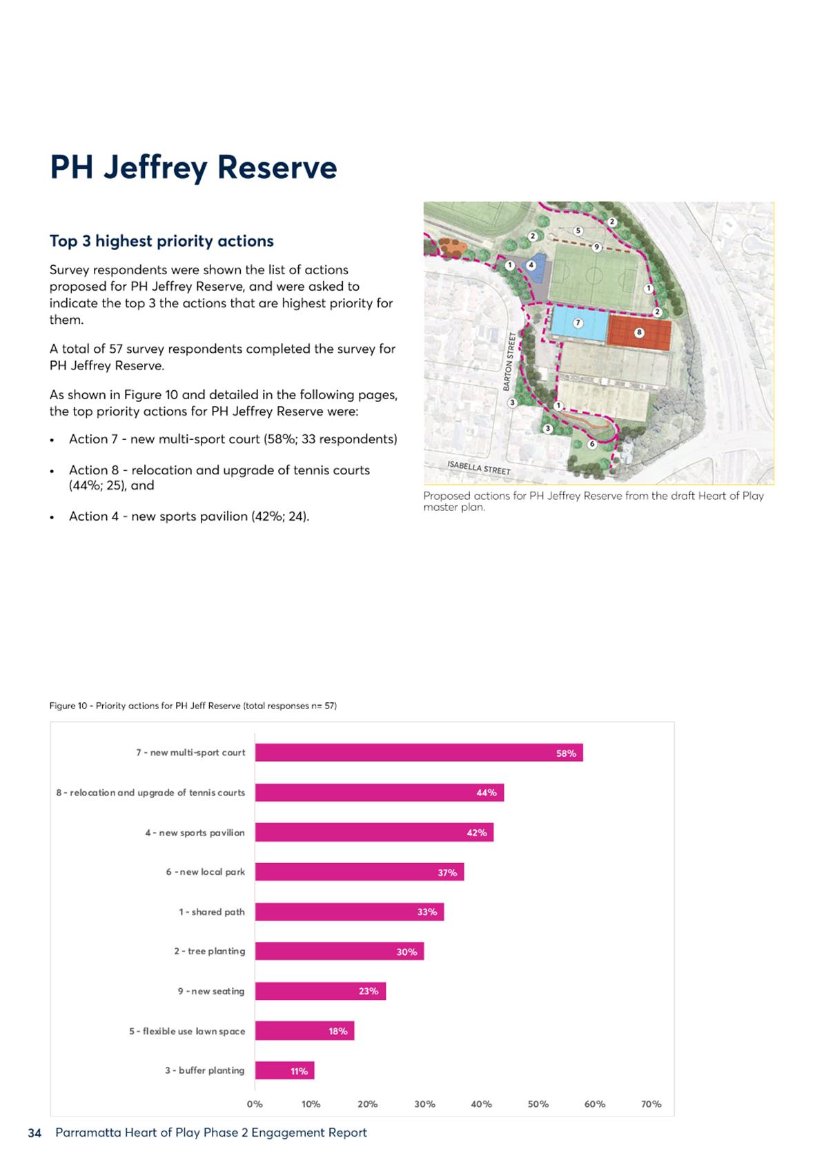
ITEM NUMBER 14.1
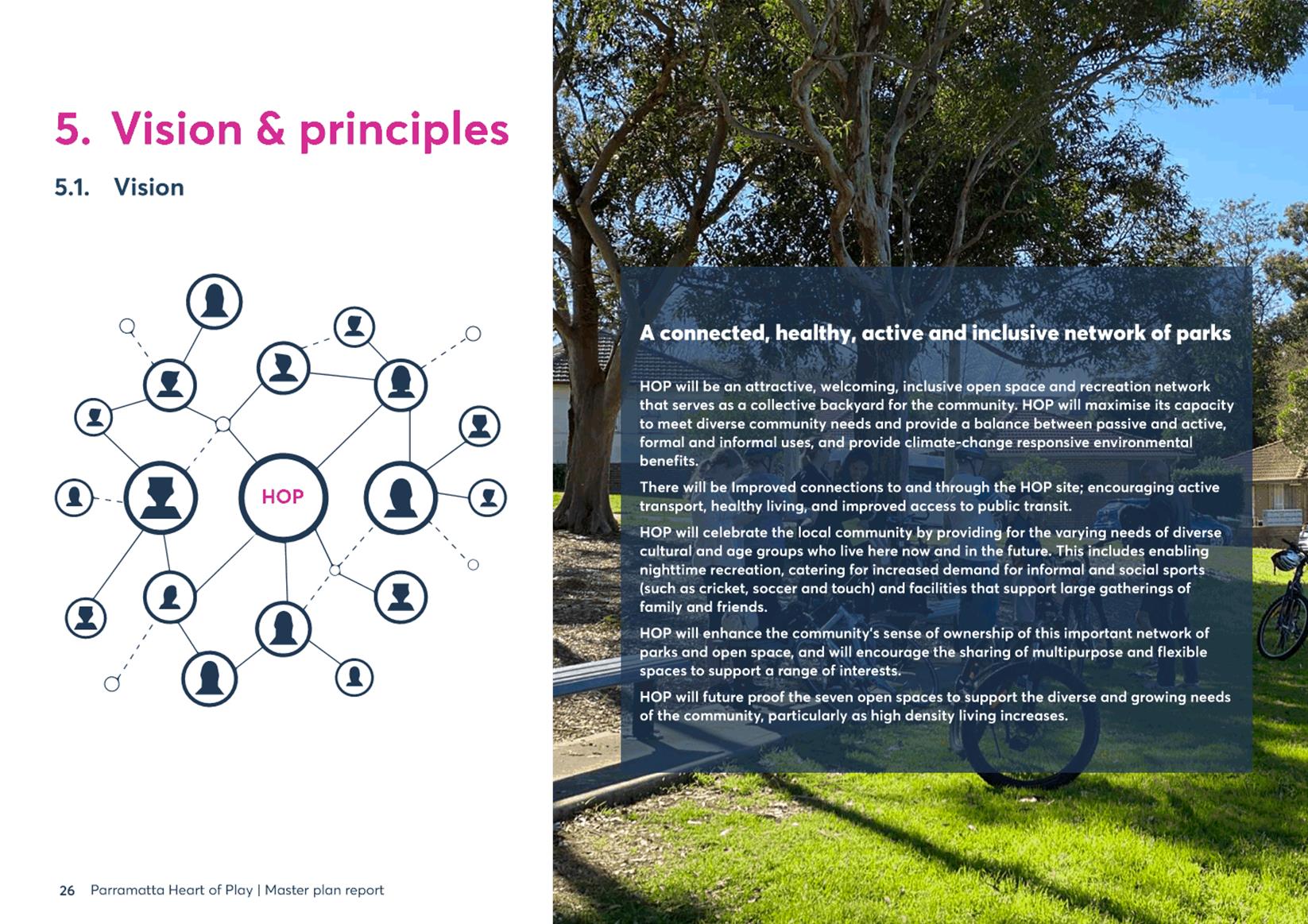
SUBJECT FOR APPROVAL: Adoption of the Heart of Play Masterplan
REFERENCE F2021/00521 - D08102731
REPORT OF Place Manager
workshop/briefing date:
Nil
PURPOSE:
To seek adoption of the Heart of Play: North Parramatta Sporting and Recreation Masterplan final design.
(a) That Council adopts the Heart of Play Masterplan as amended (Attachment 1 – Final Heart of Play Masterplan) in response to submissions received during the May 2021 public exhibition.
(b) That copies of the adopted Heart of Play Masterplan be made available to the public at the City of Parramatta Library, the Dundas Branch Library and on Council’s website.
(c) Further, that all those who provided submissions during the public exhibition period be advised of Council’s decision and thanked for their contribution to the development of the Masterplan.
BACKGROUND
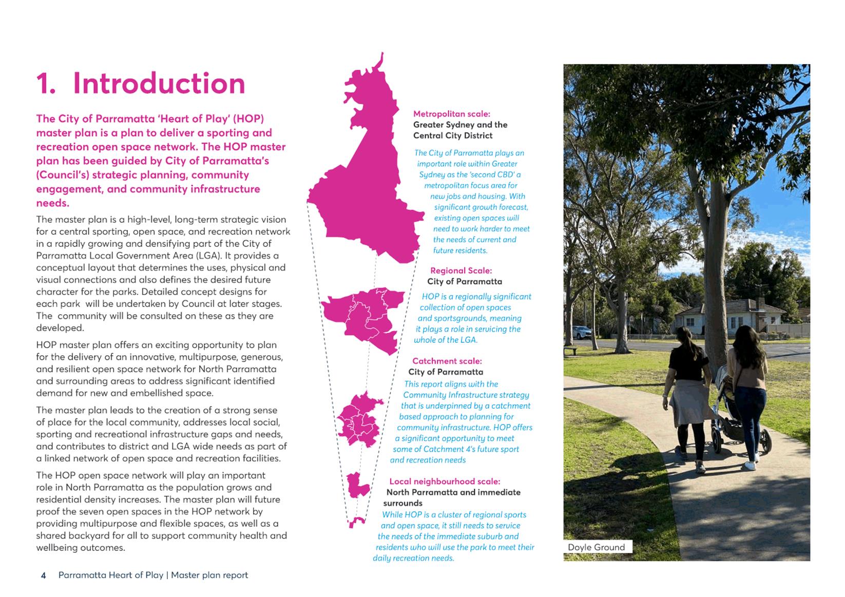
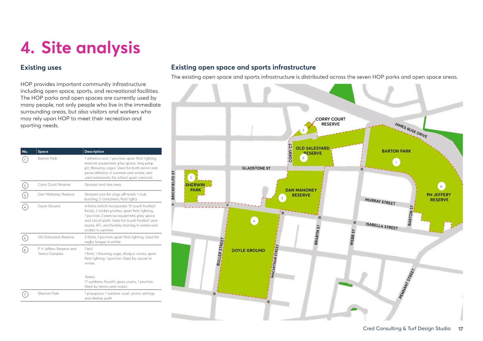
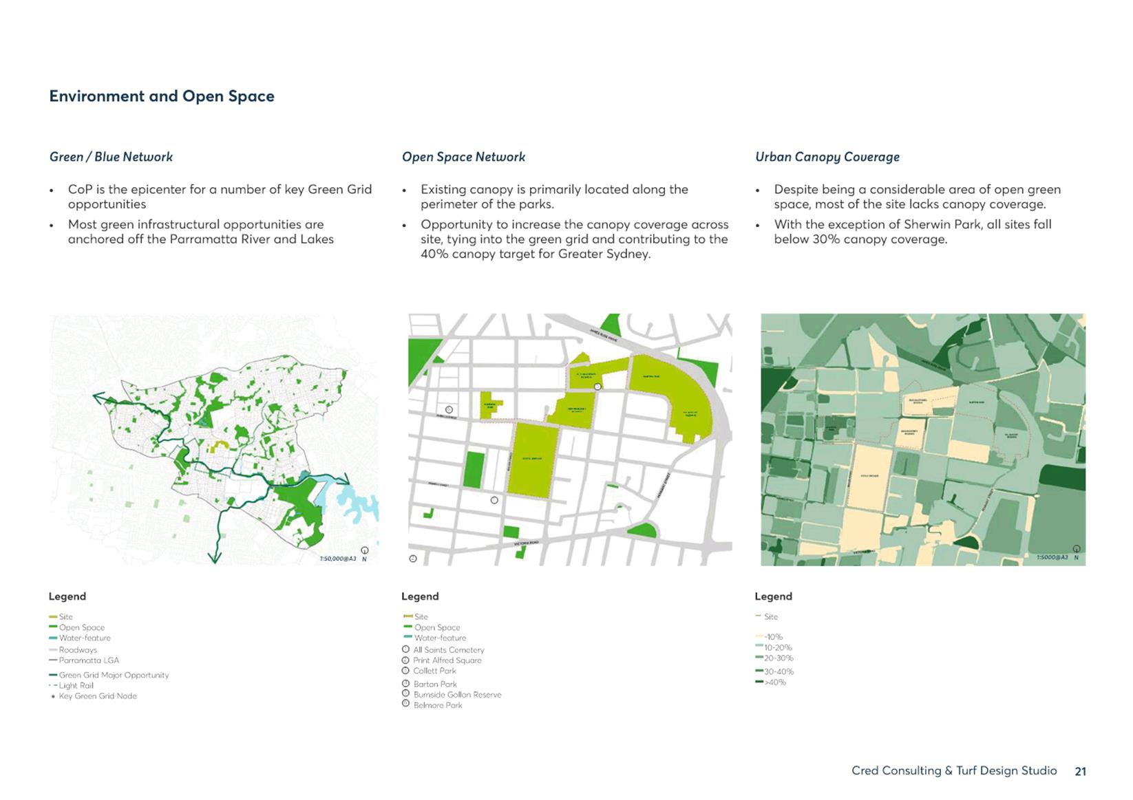
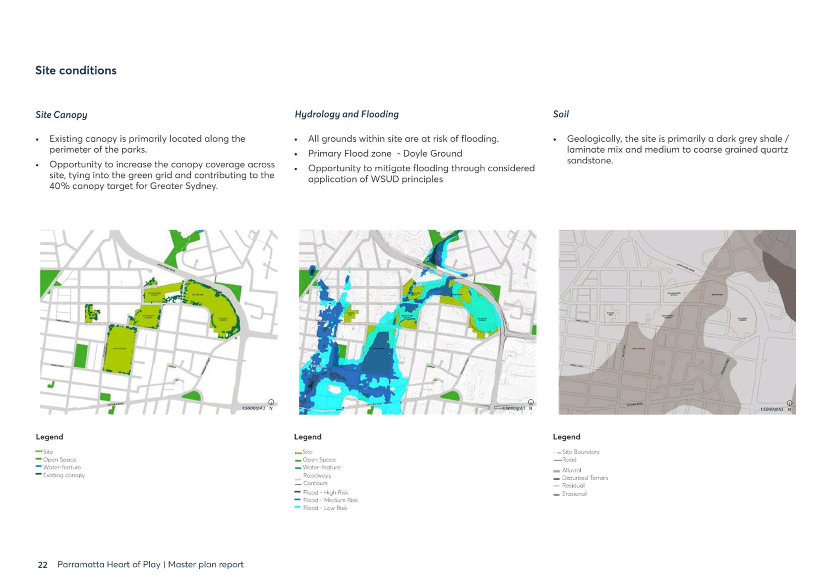
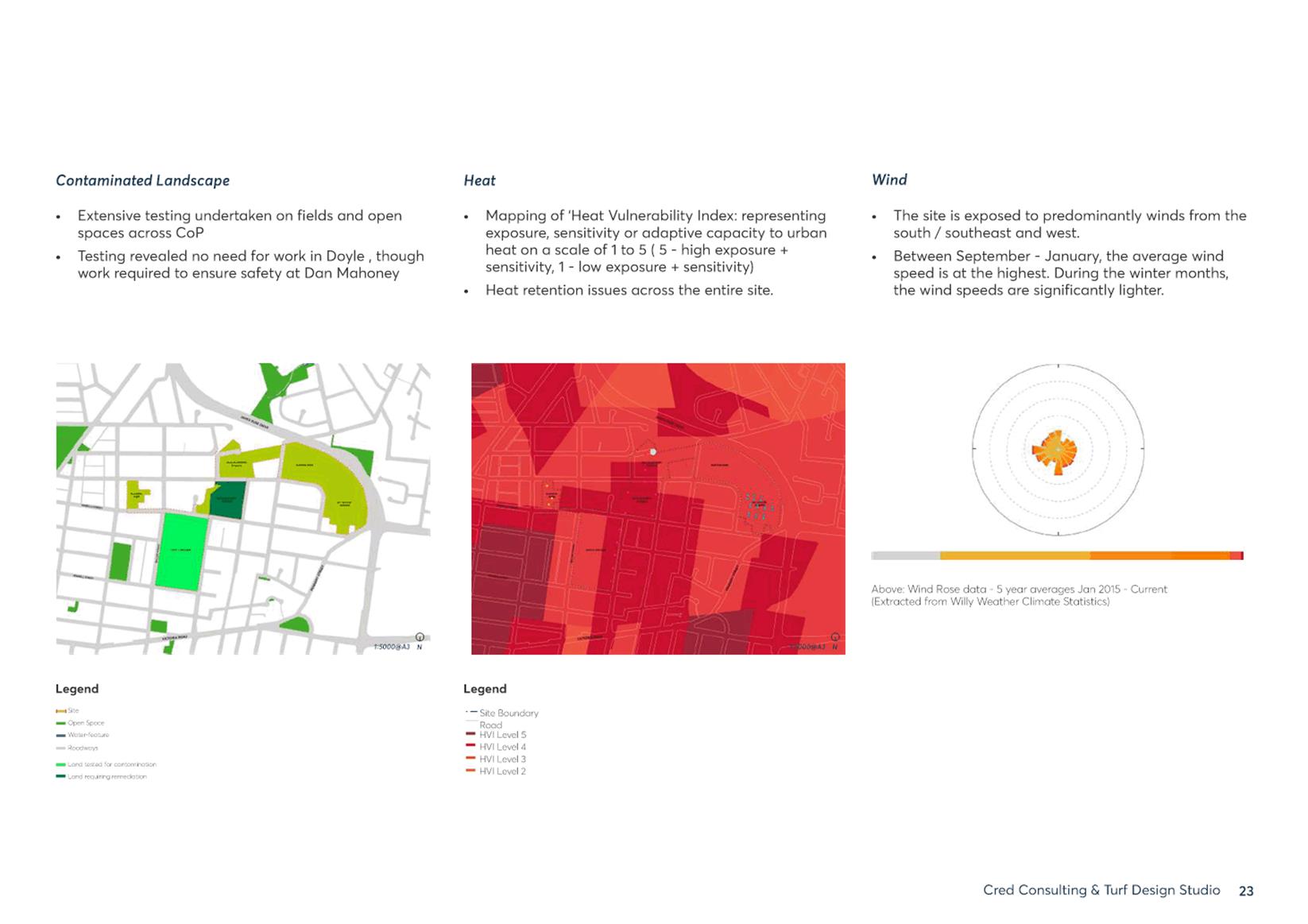
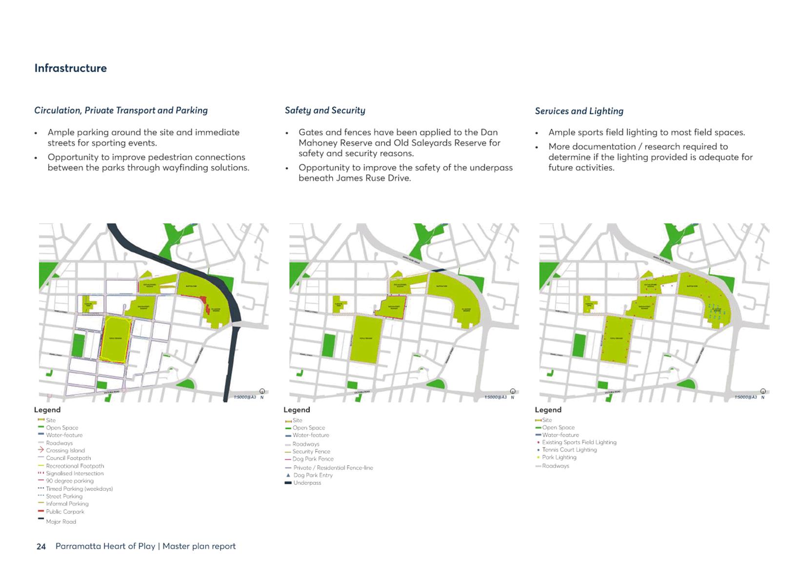
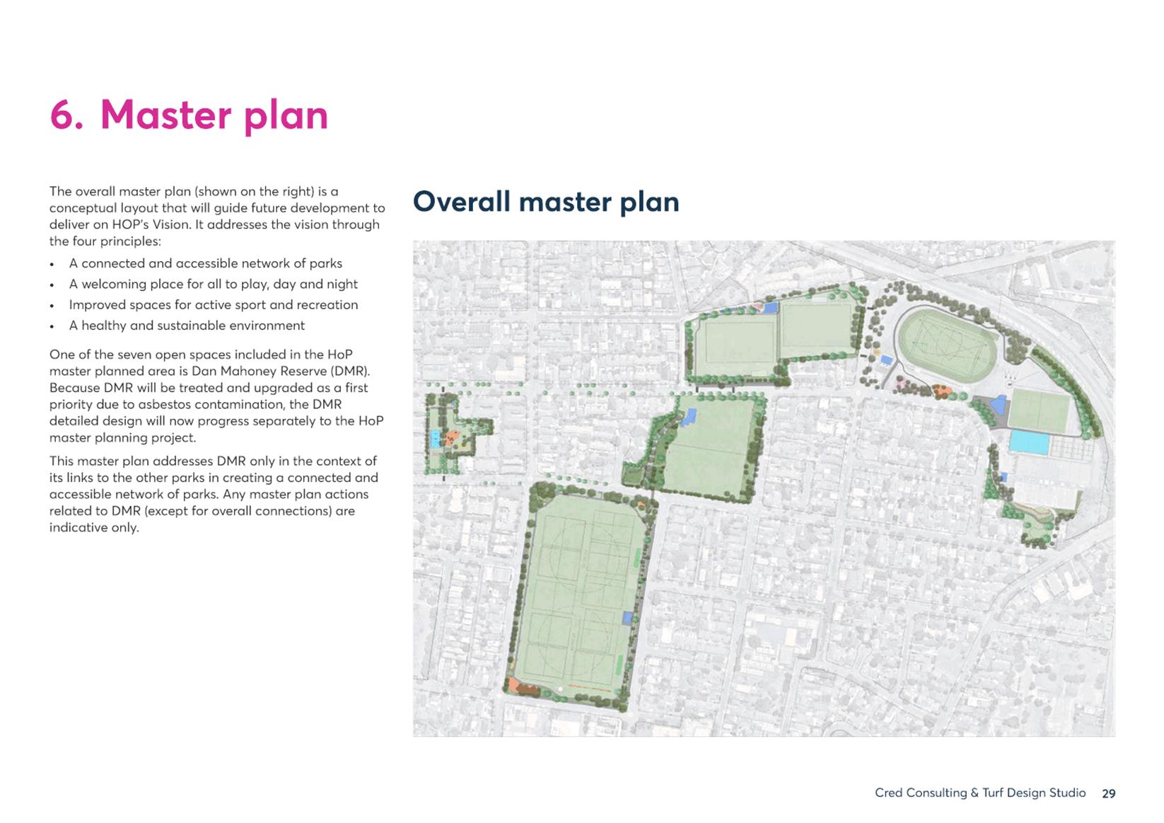
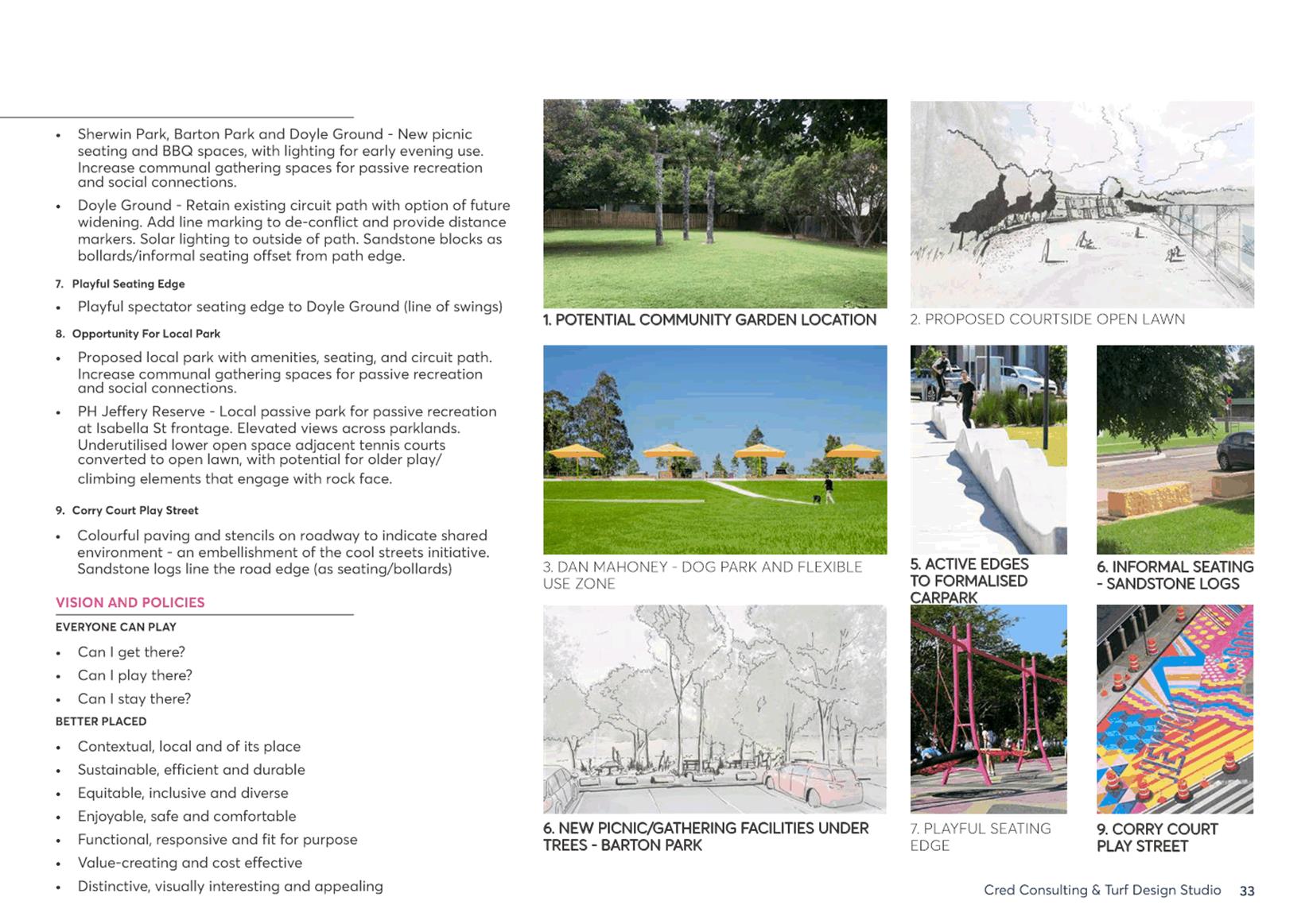
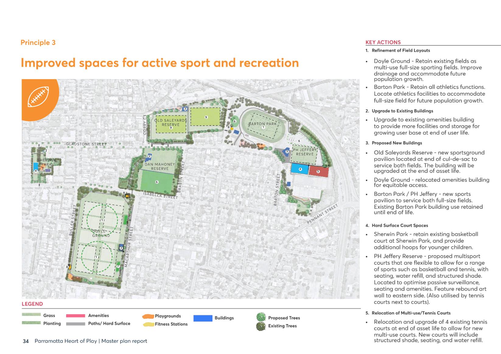
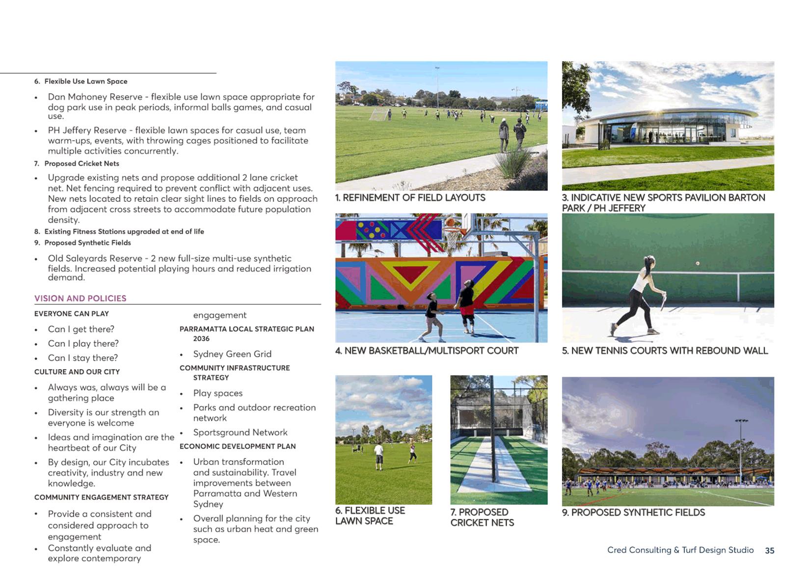
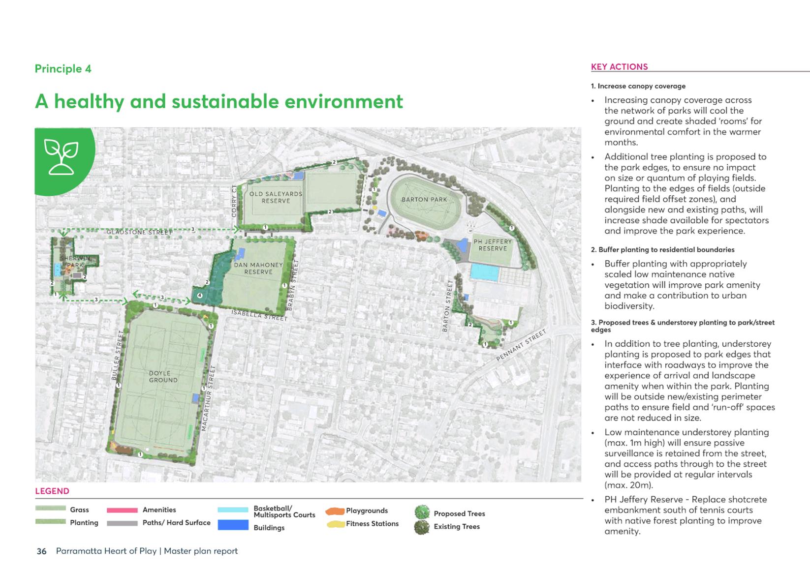
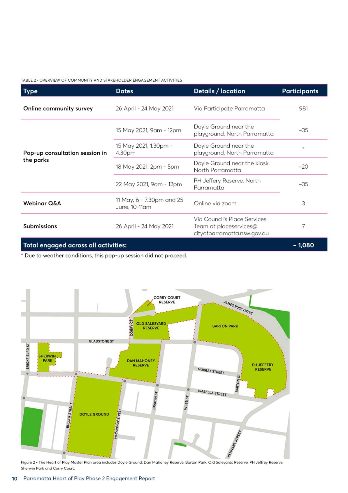
1. The Heart of Play (HoP) masterplan - community engagement and design is adopted as Focus Area 5.3.1.1 in the 20/21 Operational Plan.
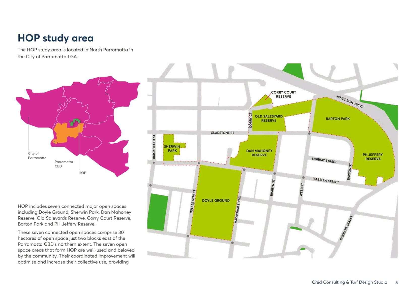
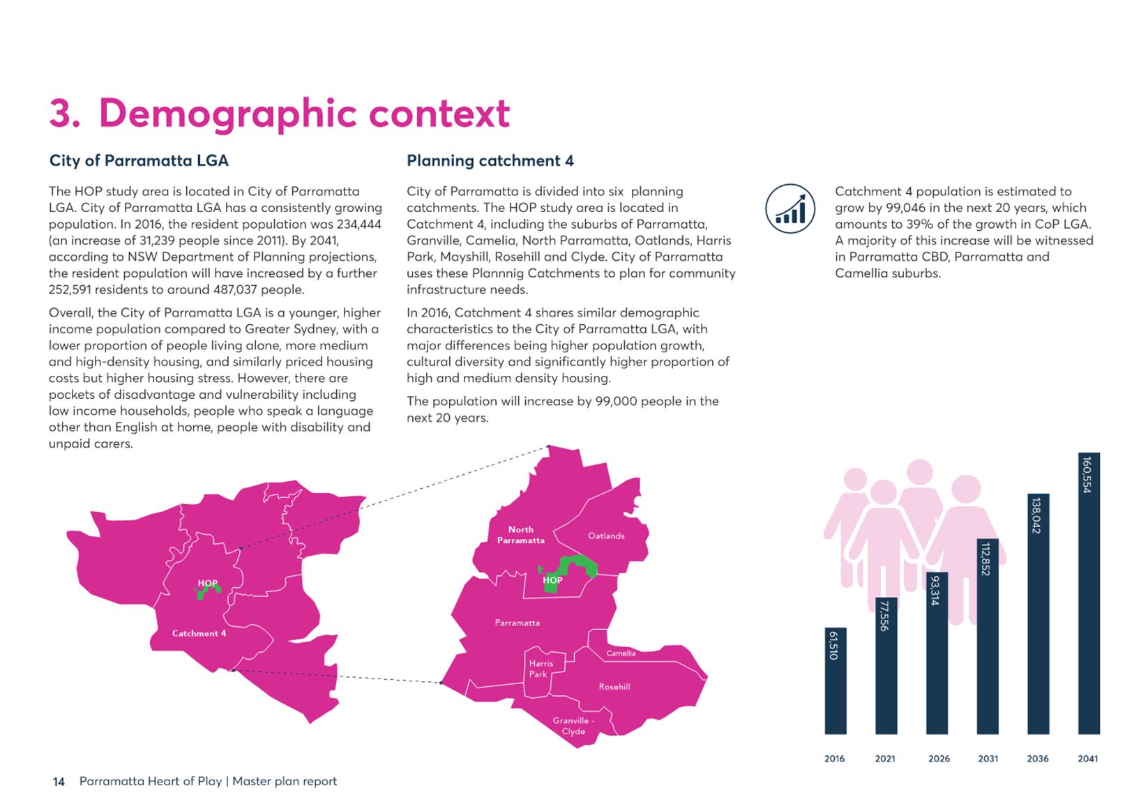
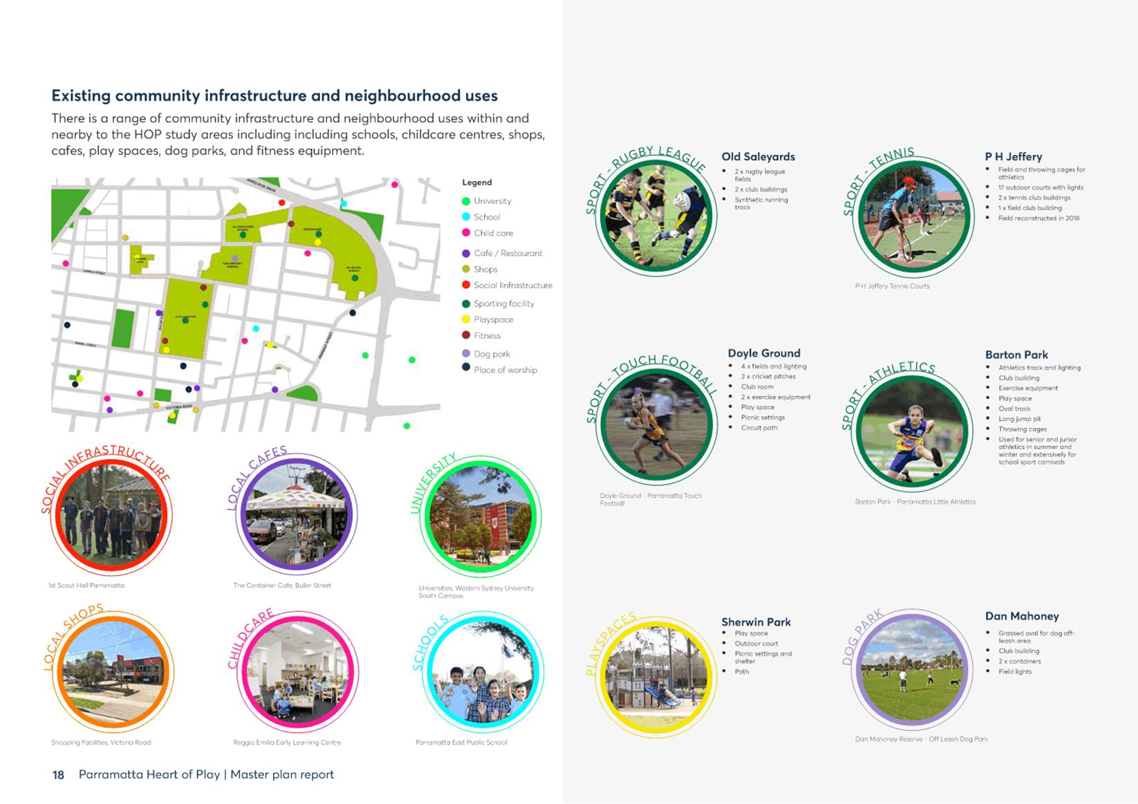
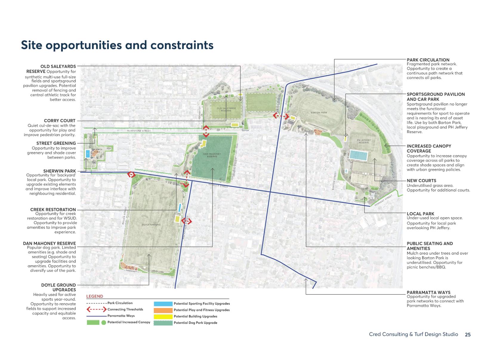
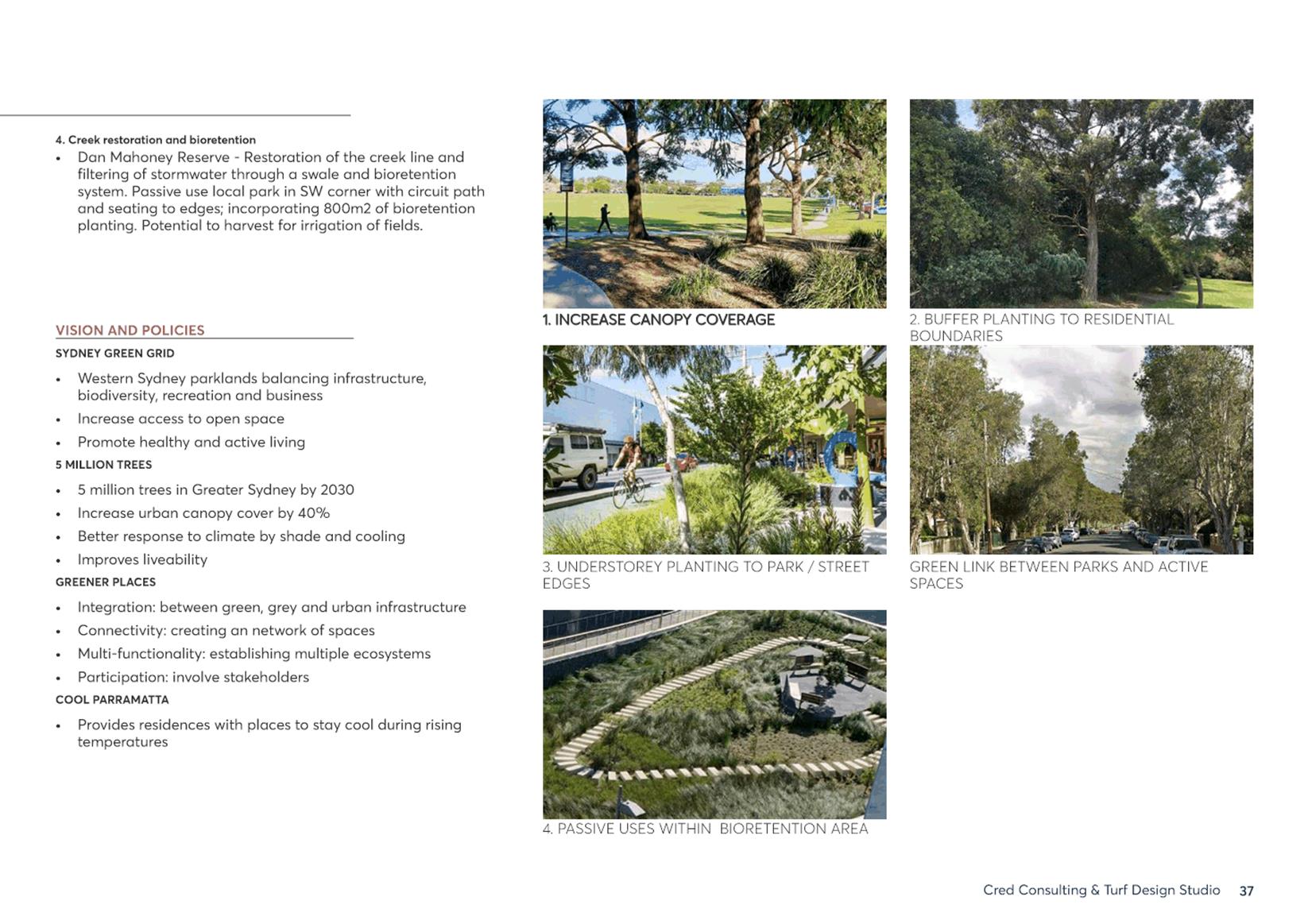
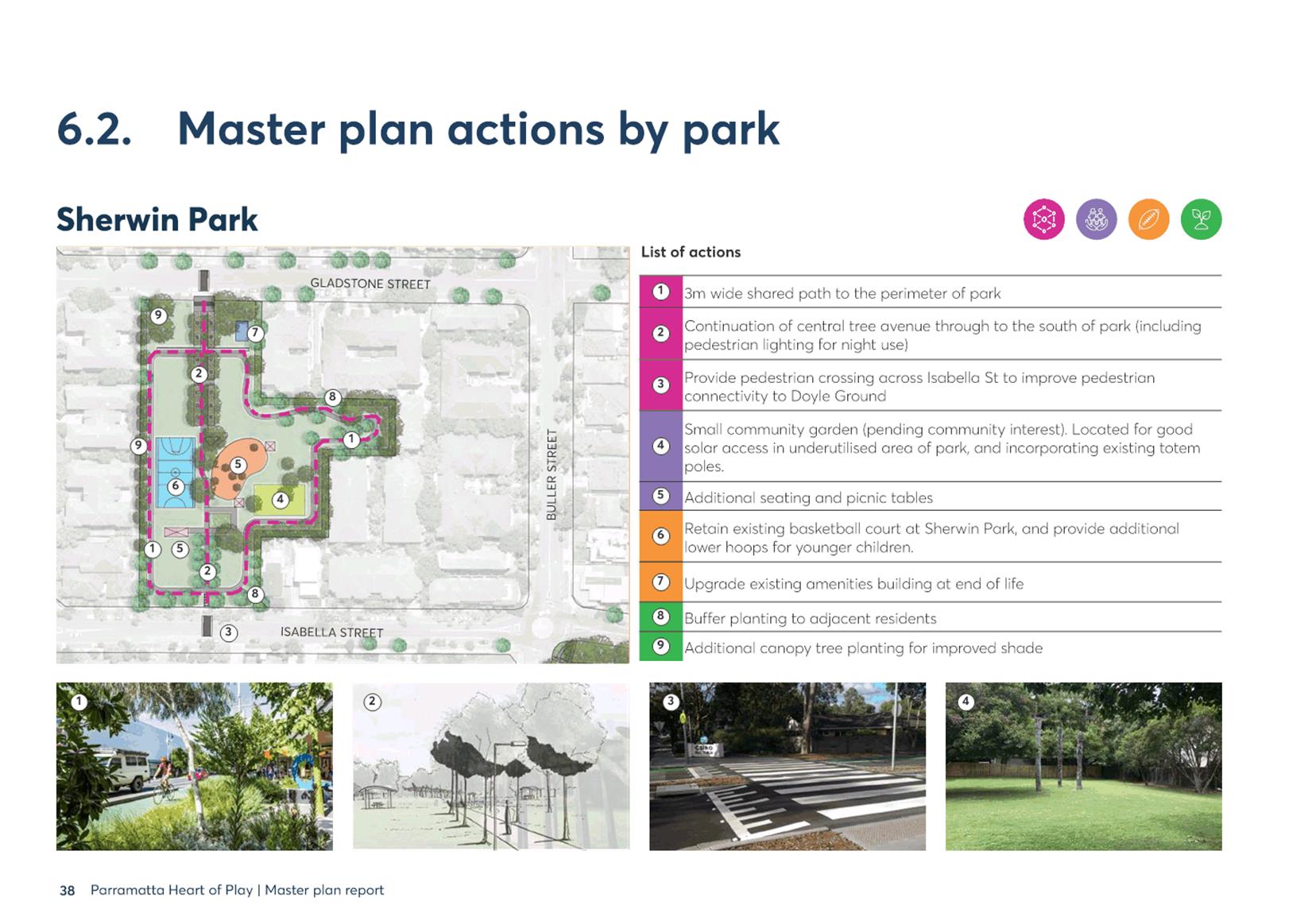
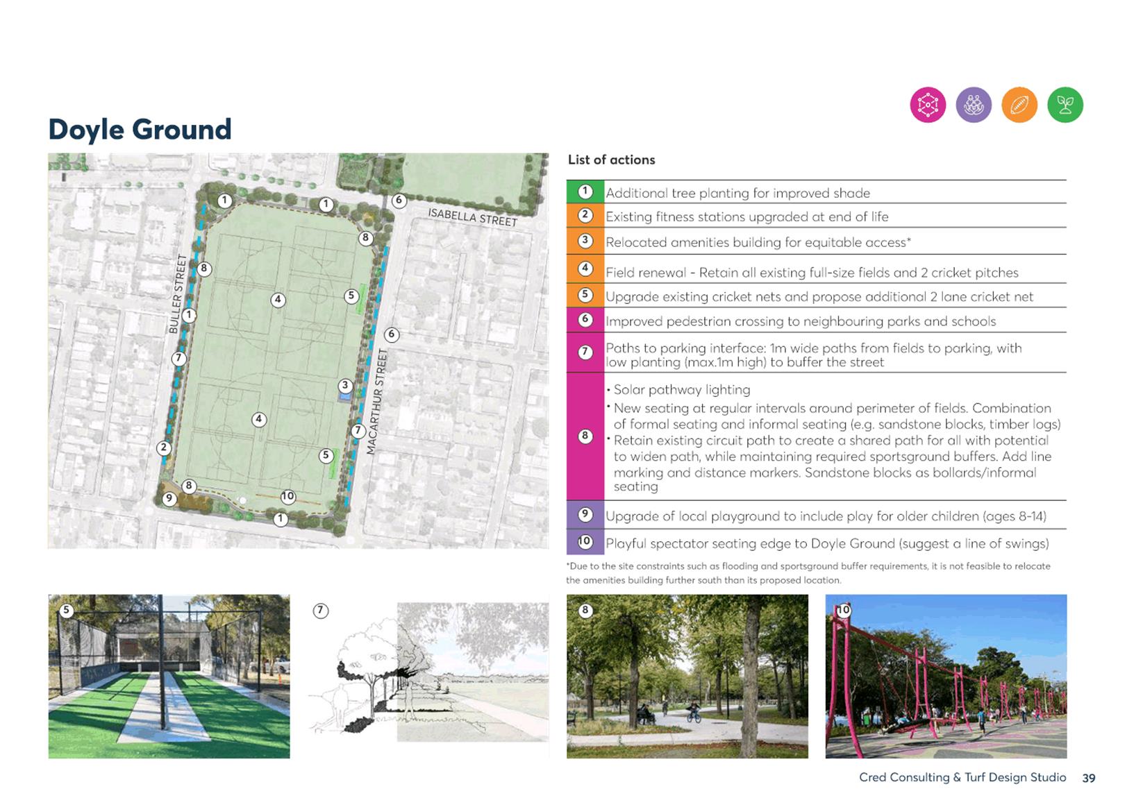
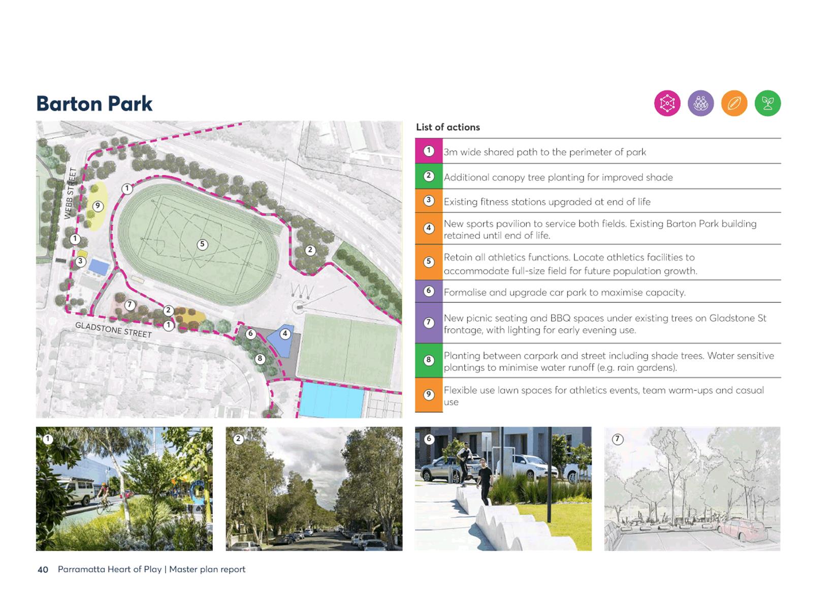
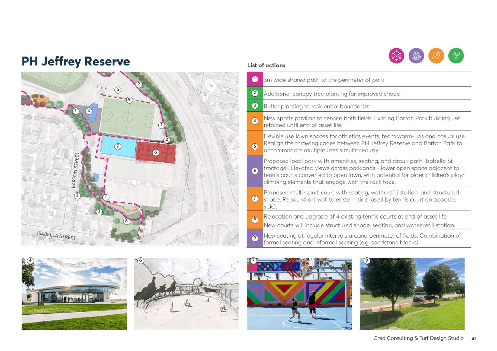
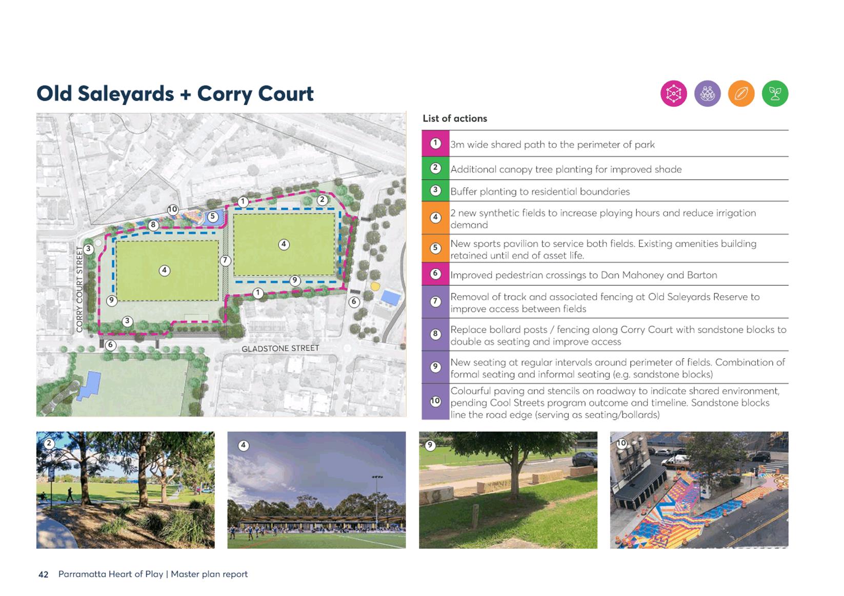
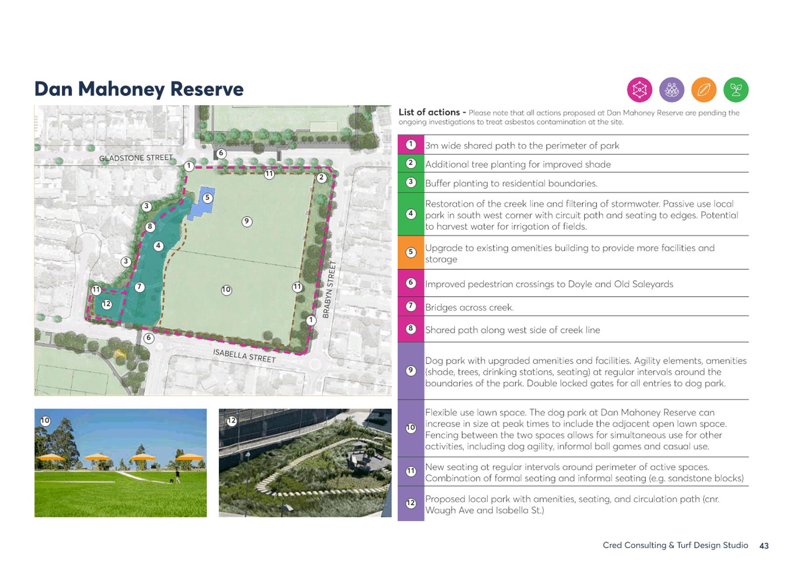
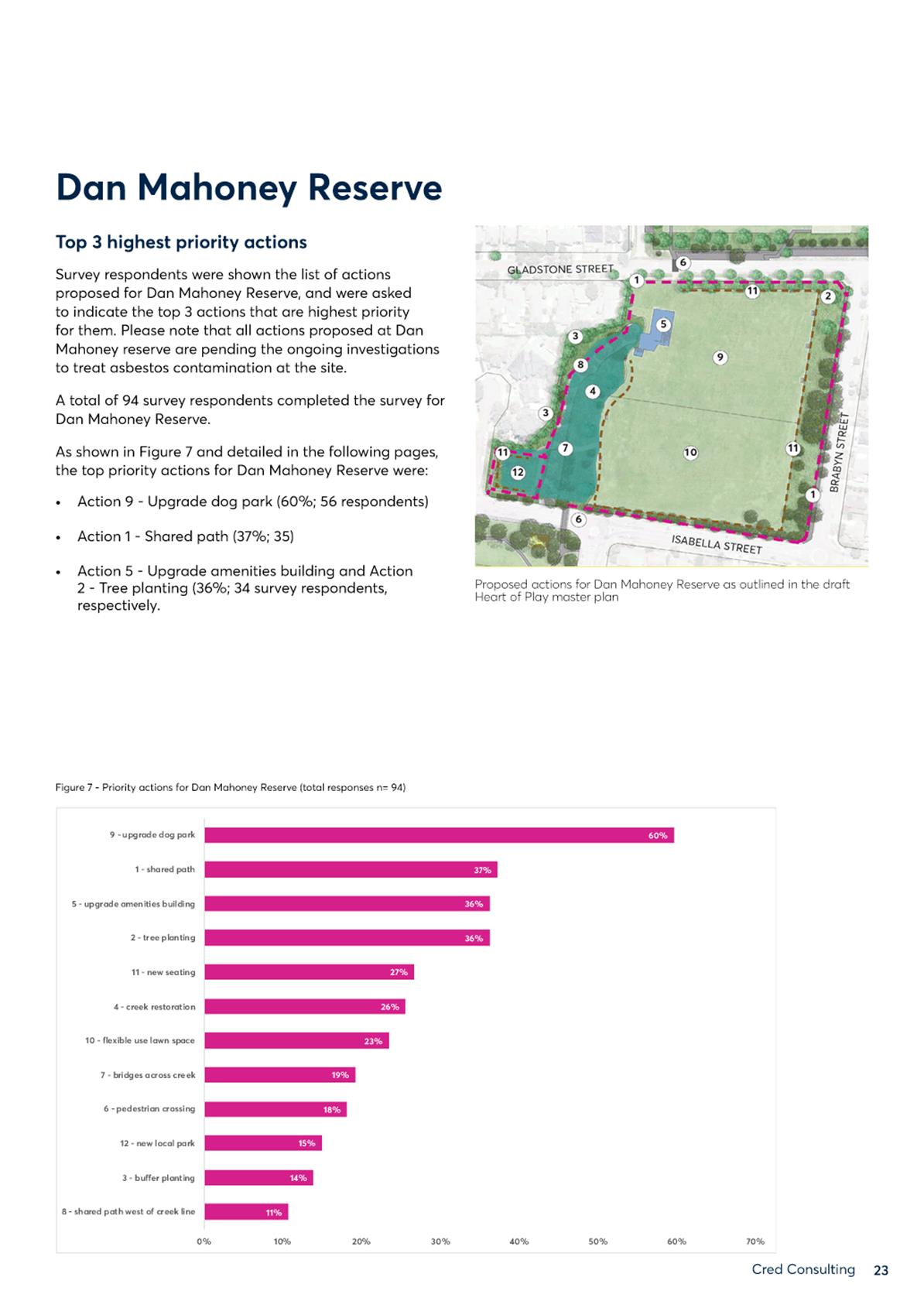
2. The masterplan design includes actions over the next 20 years in Sherwin Park, Doyle Ground, Dan Mahoney Reserve, Old Saleyards Reserve, Corry Court Reserve, Barton Park and PH Jeffery Reserve (Attachment 1).
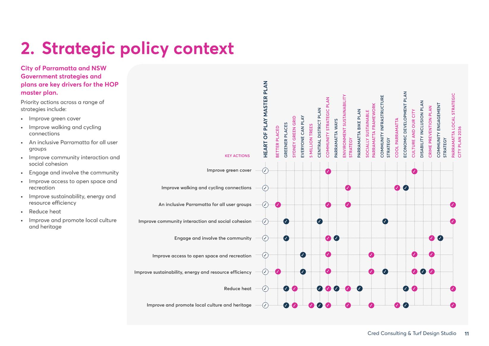
3. The HoP masterplan will be Council’s masterplan for a 30-hectare sporting and recreation network just two blocks east of the CBD’s northern extent. The masterplan has been guided by strategic community infrastructure need and community input. The HoP masterplan project provides a localised focus for 19 Council, regional, and state strategic documents.
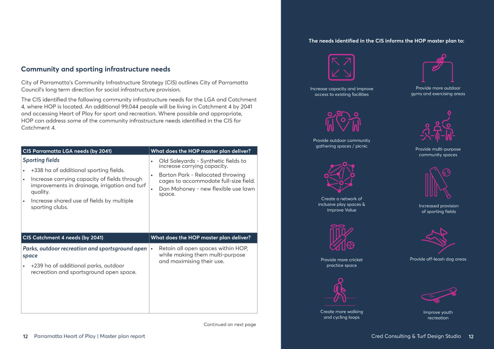
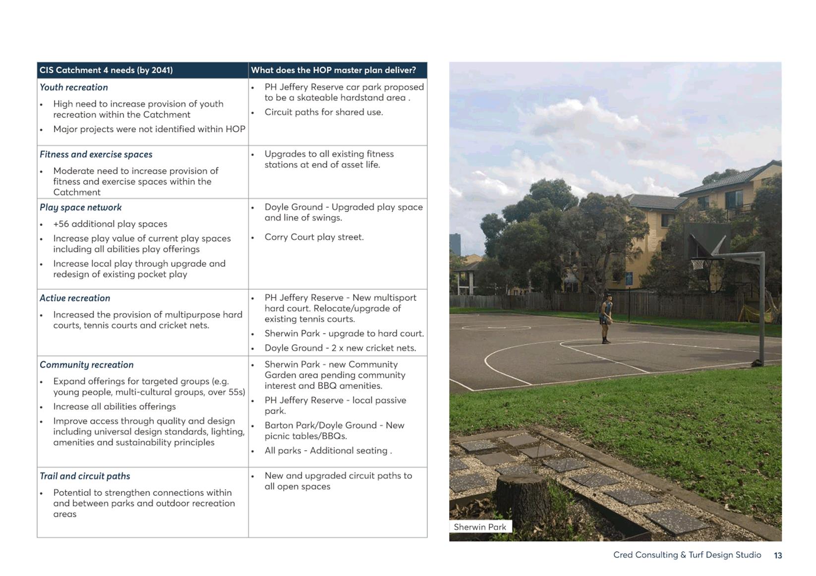
4. The HoP masterplan aligns with the Community Infrastructure Strategy by seeking to achieve the following:
i. Upgrade existing open spaces to increase their capacity to meet the growing population’s demand;
ii. Increase carrying capacity of existing playing fields through upgrades to playing surfaces and/or supporting infrastructure;
iii. Upgrade existing playgrounds to increase the number to provide a variety of play experiences;
iv. Repurpose parks to accommodate both formal and informal sports;
v. Develop better connections between open spaces and sportsgrounds; and,
vi. Repurpose alternative (non-traditional) spaces for both formal and informal sport and recreation.
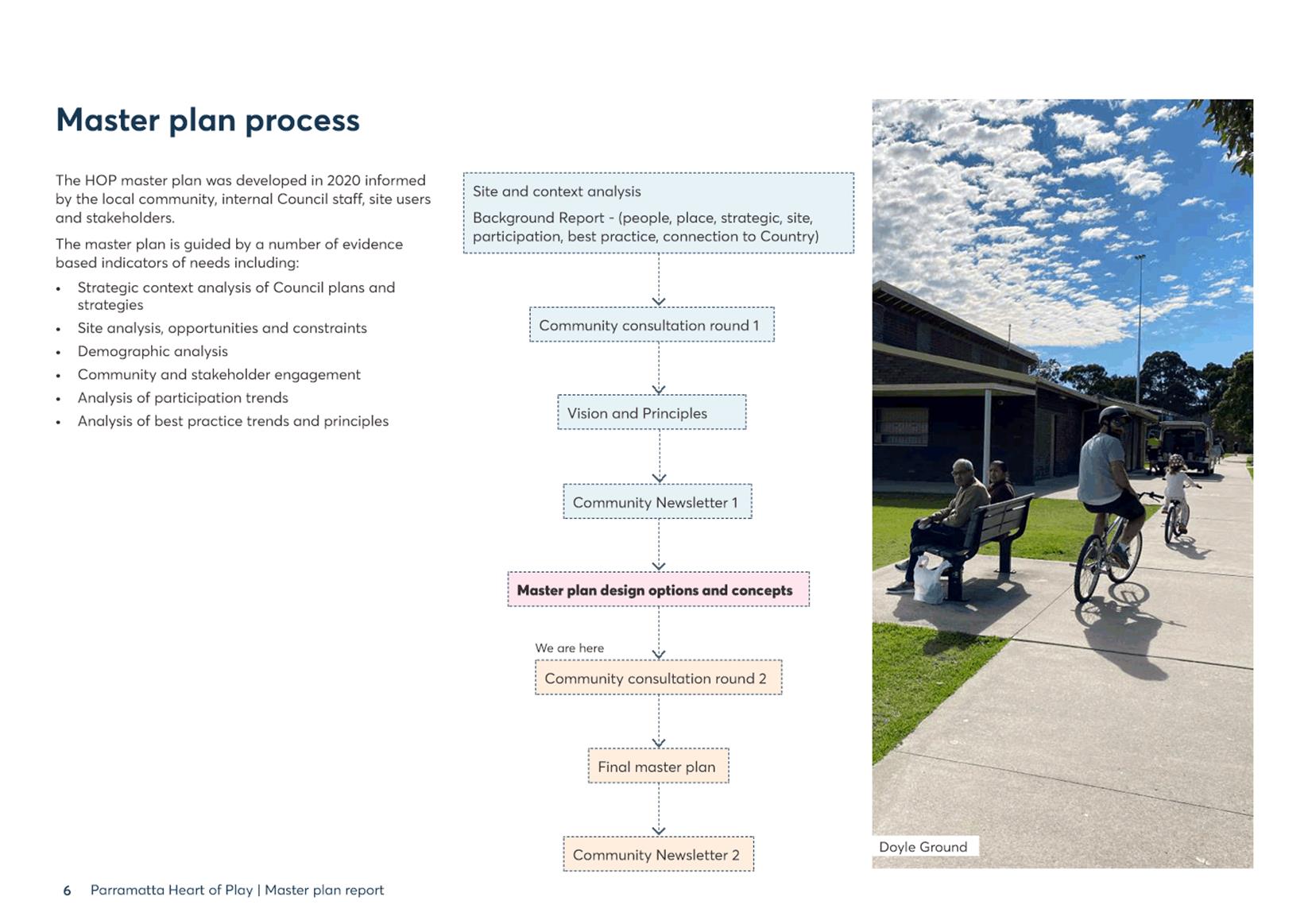
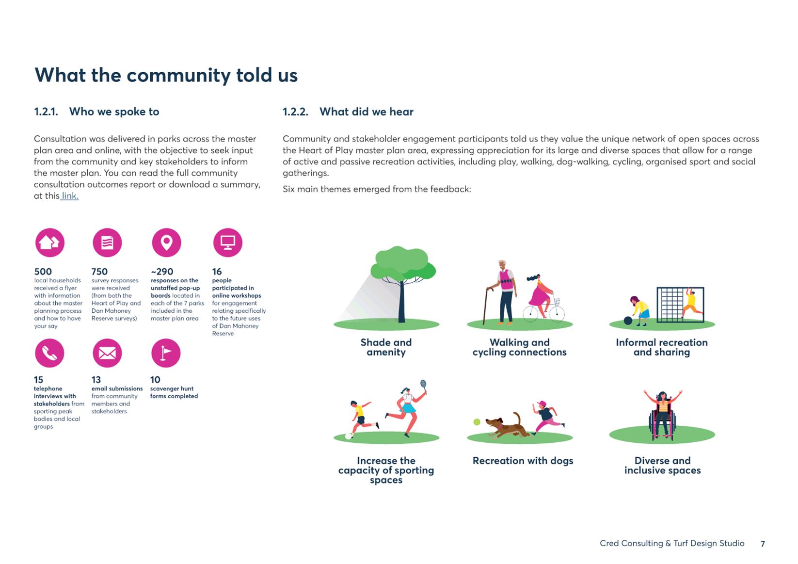
5. Community consultation for input and feedback on the draft masterplan design occurred from 29 June - 3 August 2020 and from 26 April - 24 May 2021.
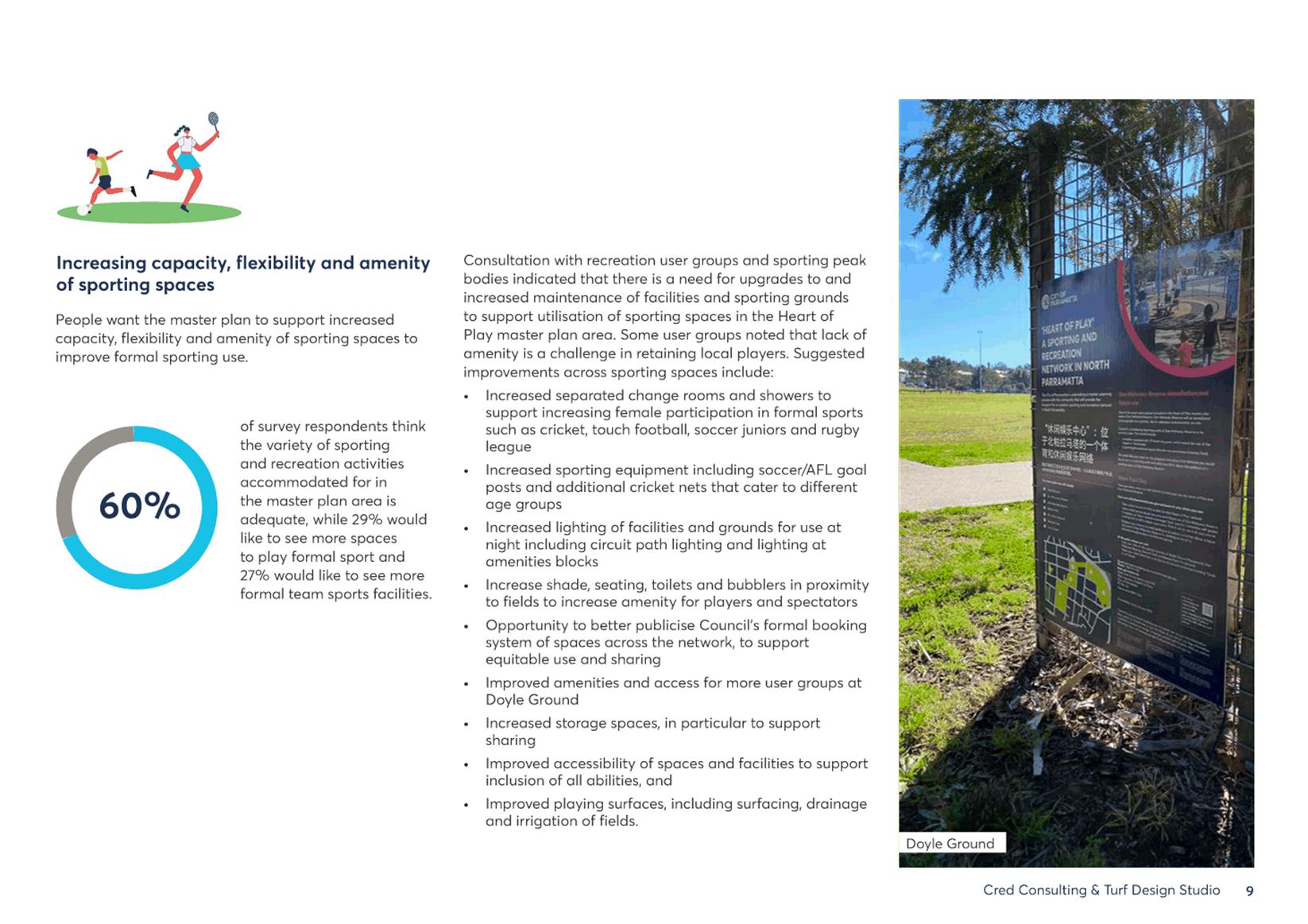
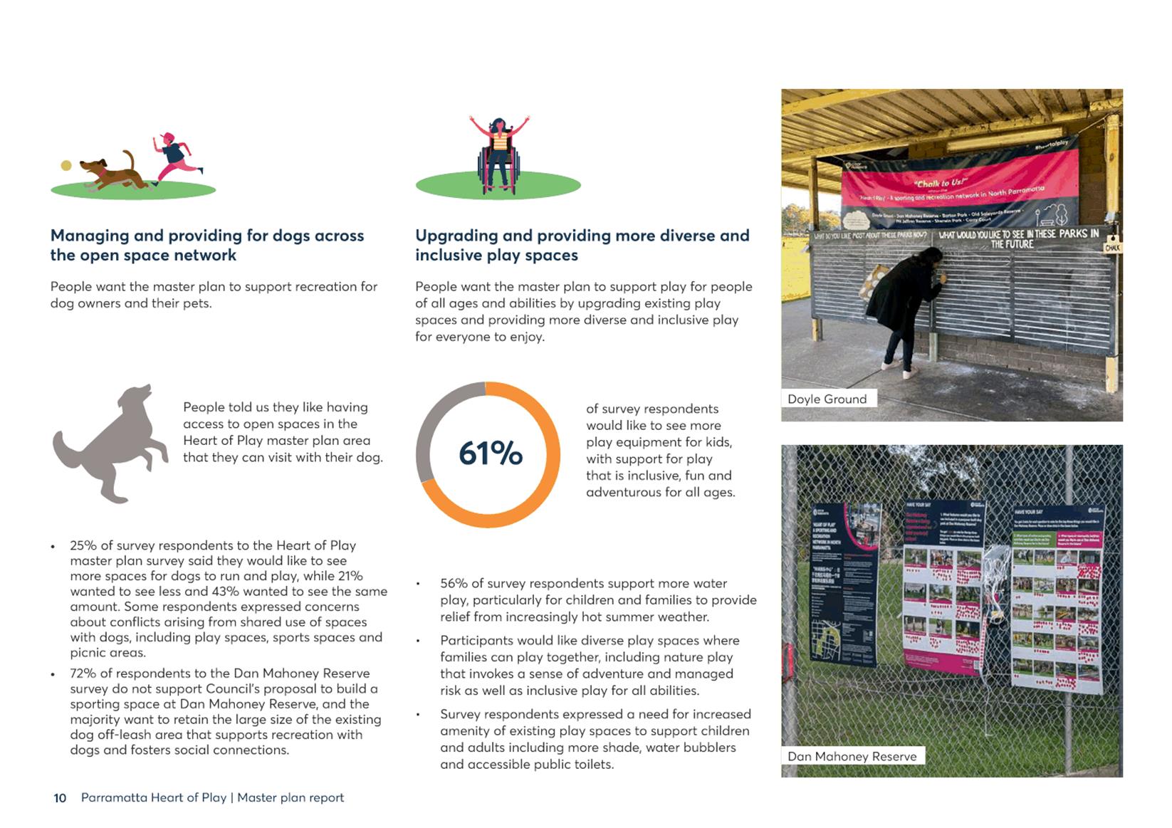
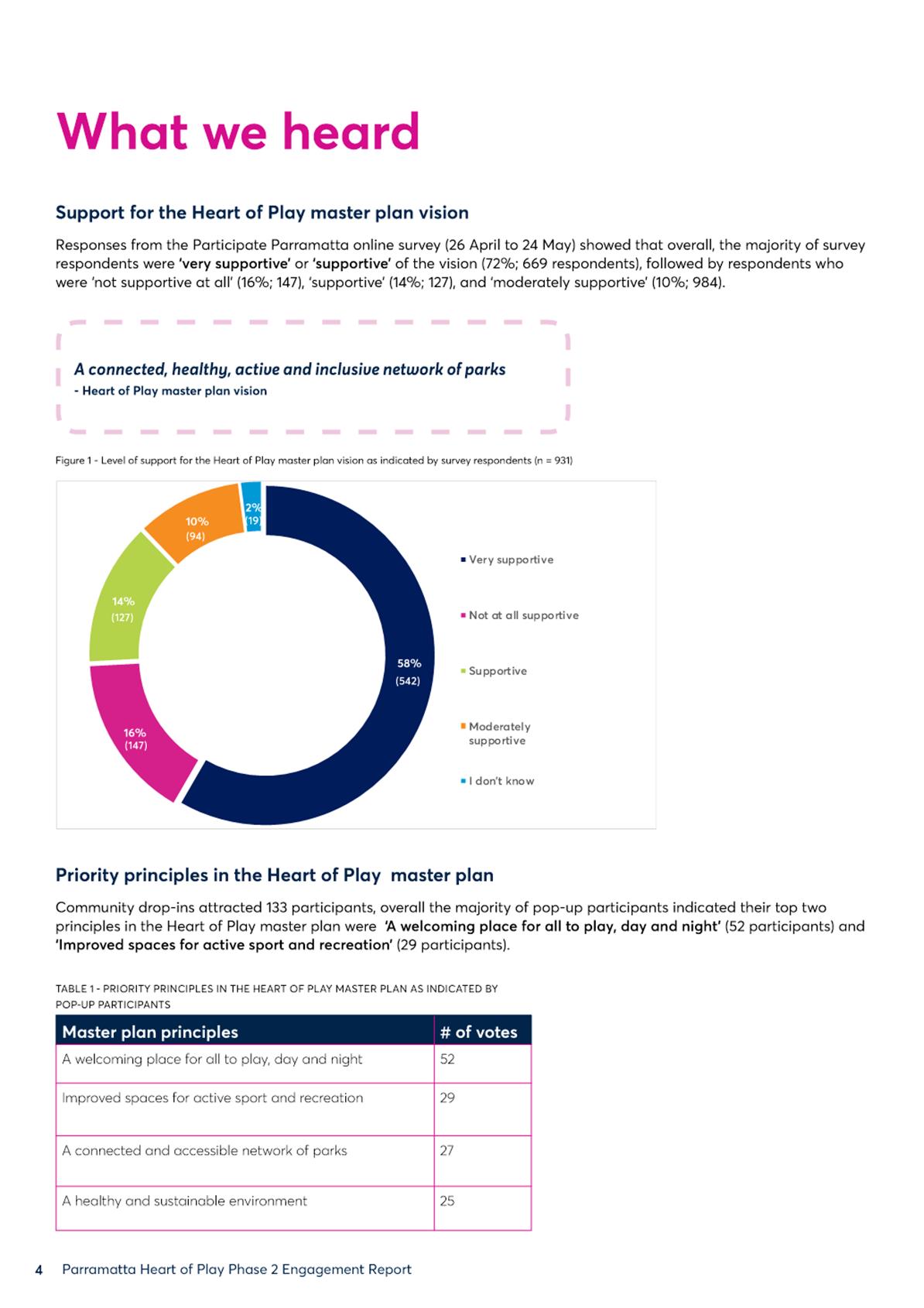
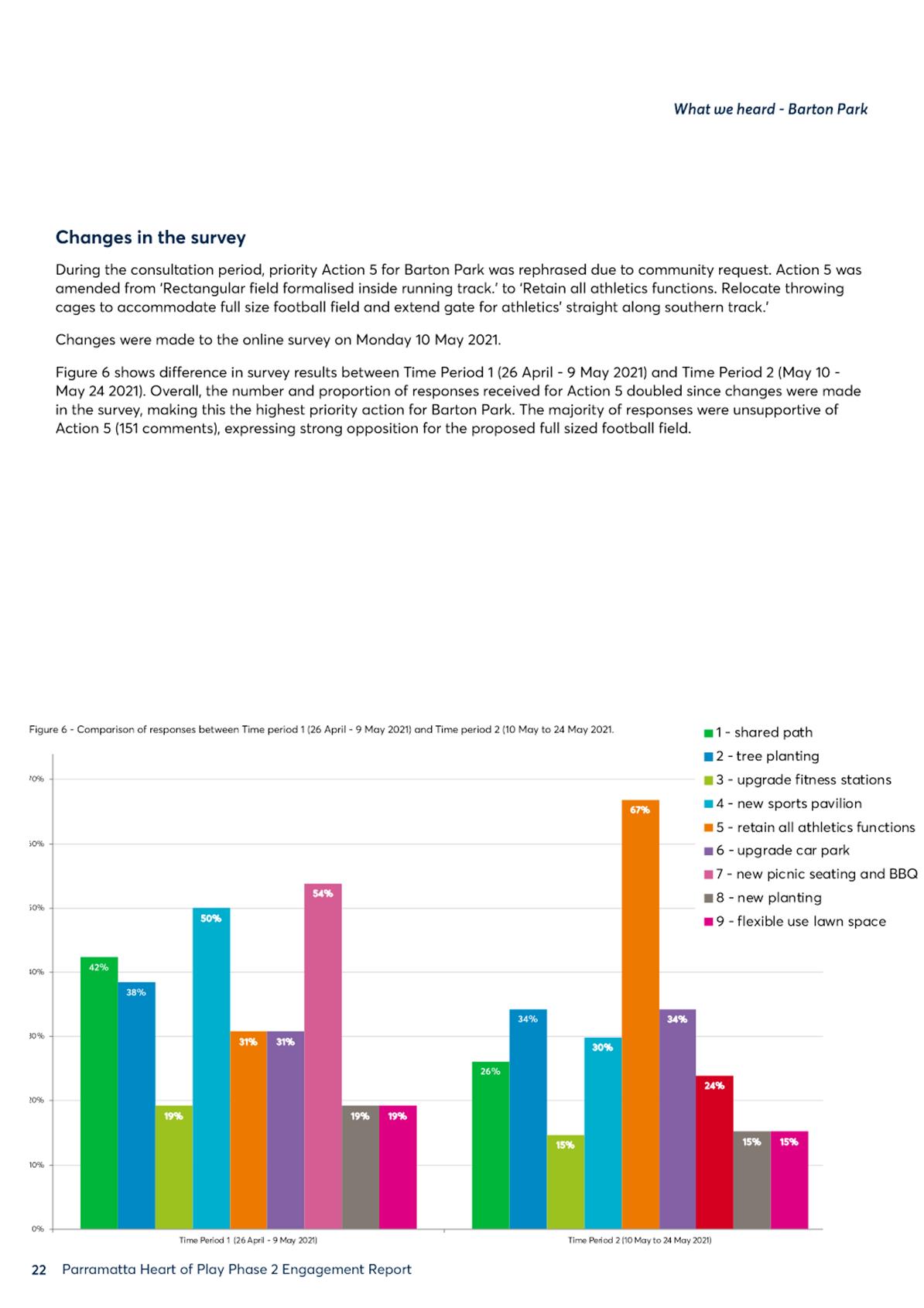
6. 1,080 responses were received during public exhibition through a range of engagement opportunities, which are summarised in the community-facing report at Attachment 2.
ISSUES/OPTIONS/CONSEQUENCES
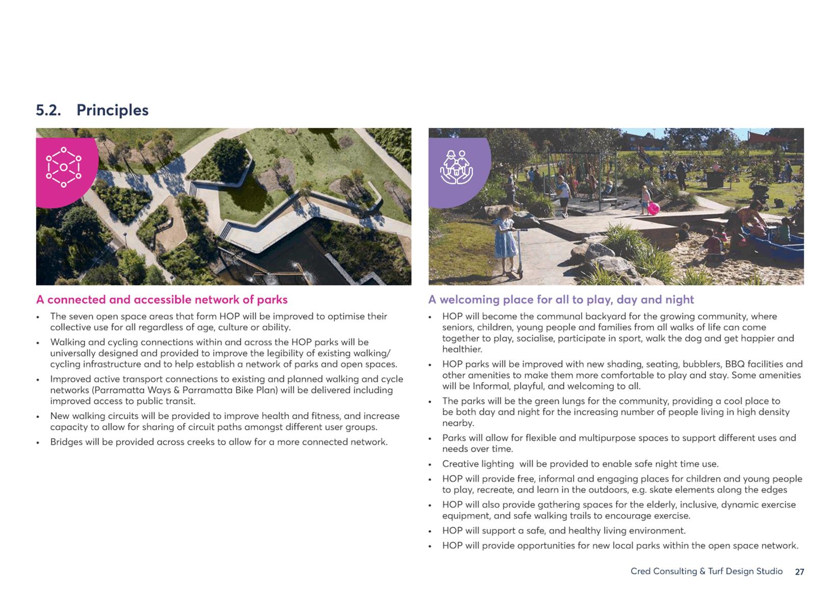
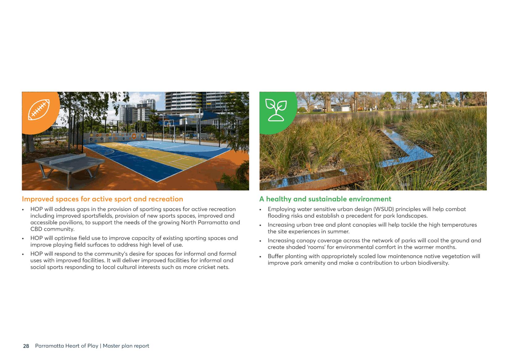
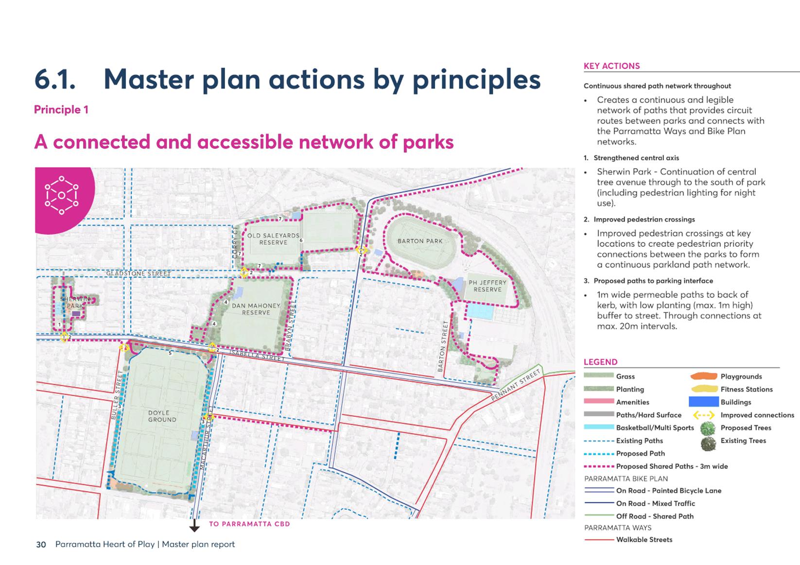
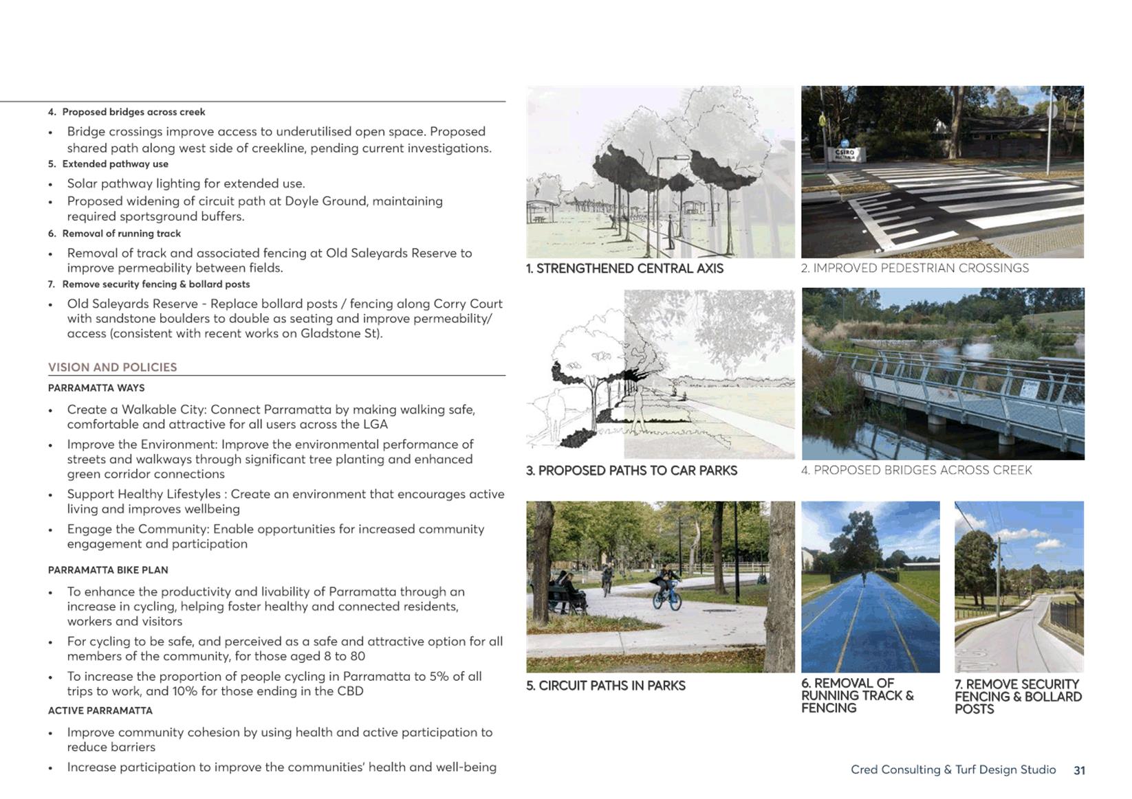
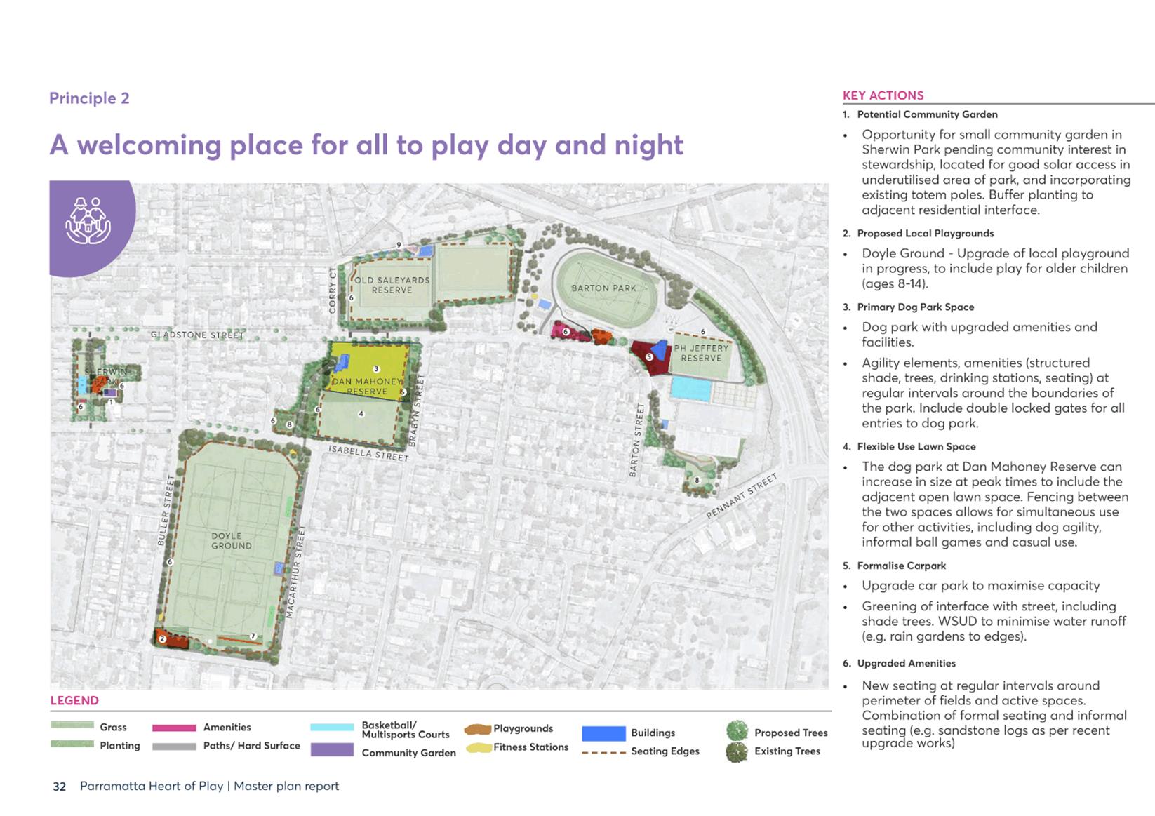
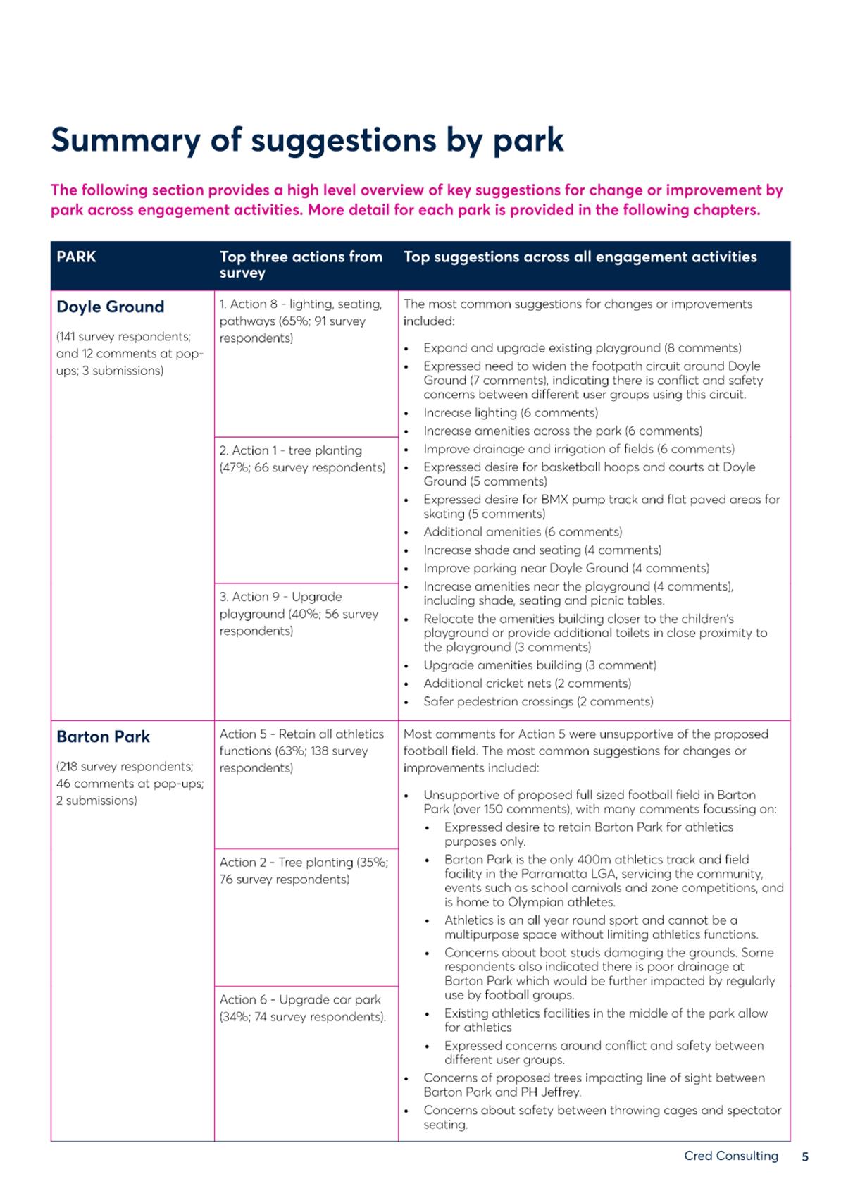
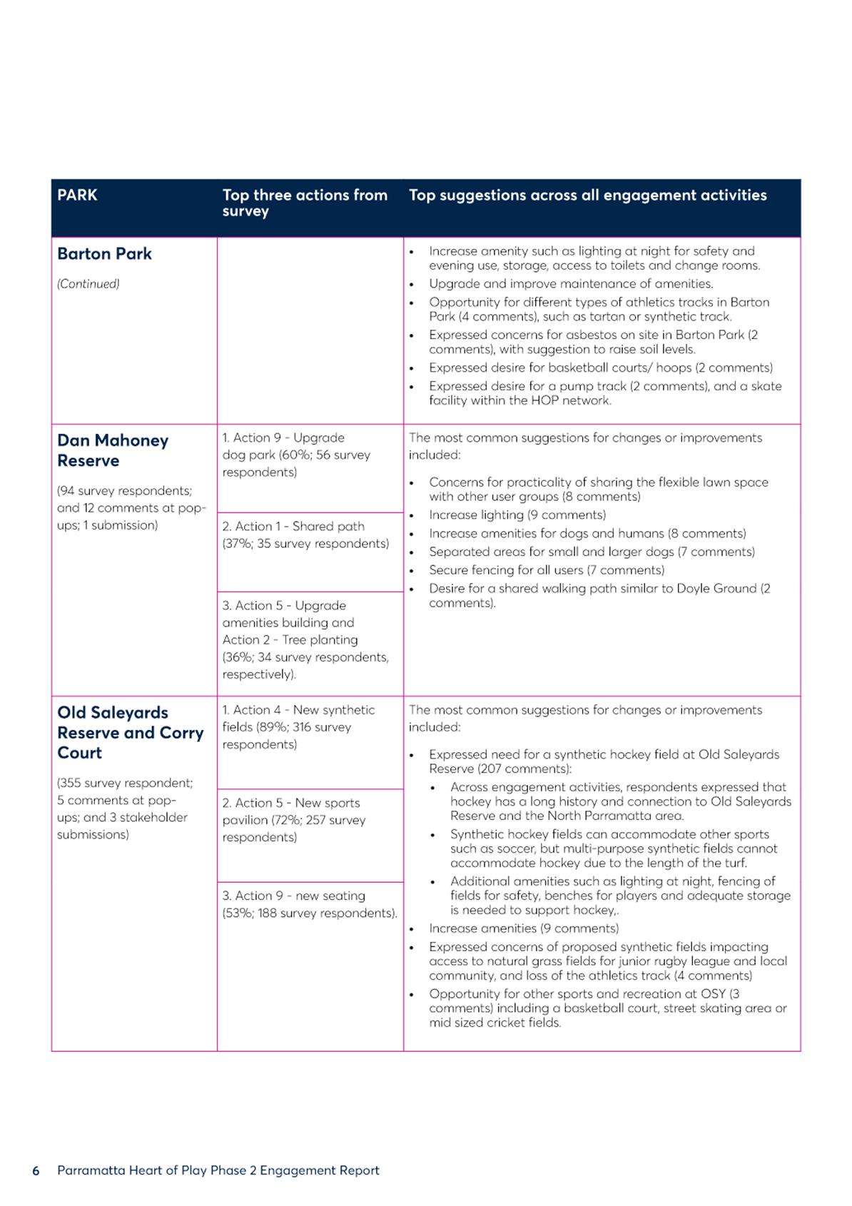
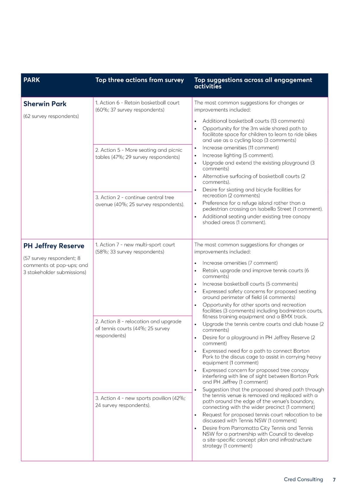
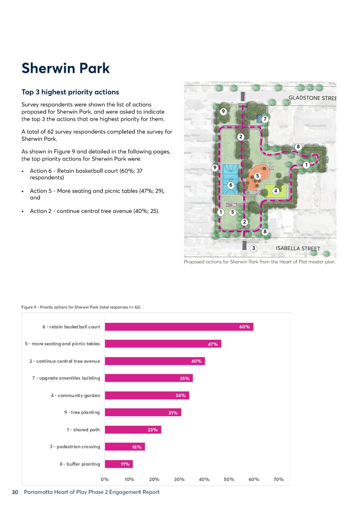
7. Four principles were developed based on community input received in the initial community consultation and shaped the masterplan design (Attachment 1):
i. A connected and accessible network of parks;
ii. A welcoming place for all to play, day and night;
iii. Improved spaces for active sport and recreation; and,
iv. A healthy and sustainable environment.
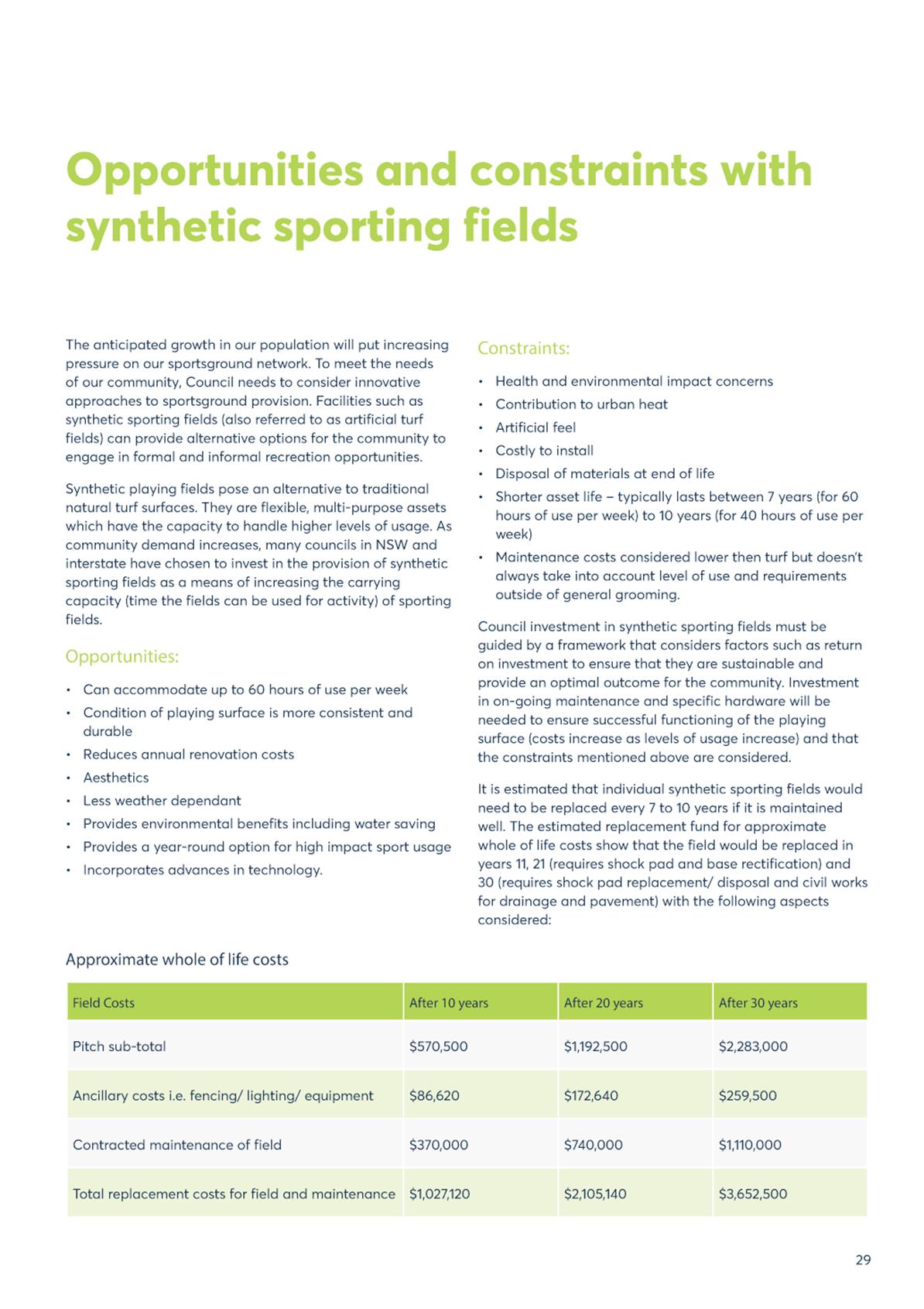
8. The masterplan design considers Council’s work-to-date and current research detailing the advantages & disadvantages of synthetic fields.
a. Opportunities and constraints of synthetic fields are summarised in Council’s draft Sportsground Strategy and Action Plan, which is anticipated to be reported to Council for public exhibition in July 2021 following a Councillor workshop 5 July. Relevant excerpts of that draft document are at Attachment 3.
b. Prior to delivering any synthetic facility, Council will produce a detailed Business Case that considers not only mitigation of environmental concerns but a range of strategies regarding replacement, maintenance and community outcome of a synthetic field.
c. Future Business Cases and sportsground planning will consider current information regarding synthetic fields and alternatives at the time of planning. Research by the Local Government Information Unit and the in-progress NSW Government Synthetic Turf Study are noted as relevant considerations at the time of this report.
CONSULTATION & TIMING
Stakeholder Consultation
9. The following stakeholder consultation has been undertaken in relation to this matter:
|
Date |
Stakeholder |
Stakeholder Comment |
Council Officer Response |
Responsibility |
|
Multiple from project inception |
Internal stakeholders: City Engagement, City Assets & Enviro., Social & Comm. Services, City Strategy |
Collaboration and input on masterplanning and design |
Integration of input in draft design |
Place Services / Roz Palmer (RP) |
|
29 June - |
Neighbouring residents (0.5km radius); community organisations; businesses; schools |
Various regarding design input |
Integration of input in draft design |
Places Services / RP & Community Engagement |
|
24/2/21 |
Registered community members via a Community Newsletter email and update to webpage |
n/a |
Informing the community of progress, next steps, and that HoP public exhibition will be separate to DMR public exhibition |
Place Services / RP |
|
26 April - |
All listed in #14 below |
Various regarding design feedback (Attachment 2) |
Amendments to master plan design (Attachment 3) |
Places Services / RP & Community Engagement |
Councillor Consultation
10. The following Councillor consultation has been undertaken in relation to this matter:
|
Date |
Councillor |
Councillor Comment |
Council Officer Response |
Responsibility |
|
19/2; 21/5; 1/6; 20/9; 30/9; 8/10; 9/12 in 2020 & 24/2; 14/4; 5/19 in 2021 |
Ward Councillors: DLM Garrard, Crs Barrak and Esber |
Various regarding community need and agreement with community priorities |
Integration of community input and feedback in draft and final designs |
Place Services / RP & Chris Patfield |
|
19/6/20; 17/11/20 |
All Councillors |
n/a |
2 Councillor Briefing Notes: 1 for HoP community consultation and 1 dedicated to DMR |
Places Services / RP & Legacy Asbestos, Erin Lottey |
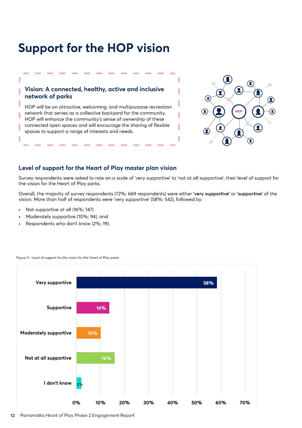
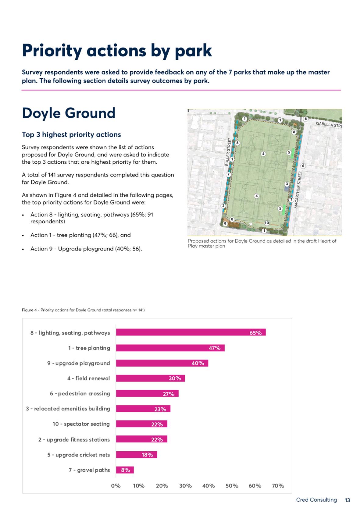
11. The majority of the community feedback (72%) was supportive of the Masterplan. Attachment 2 provides a summary of engagement results.
12. Attachment 4 summarises Council’s amendments to the Masterplan in response to key issues raised during public exhibition.
13. The initial round of COVID-safe consultation for community input from 29 June - 3 August 2020 received 1,081 responses, which were reported to Council 12 April and summarised on the Heart of Play Participate Parramatta webpage along with other project reports and resources: participate.cityofparramatta.nsw.gov.au/HOP_DAN.
14. The following stakeholder groups were made aware of the public exhibition of the Heart of Play masterplan, as resolved 12 April 2021:
i. All current and former sporting user groups accessing playing fields in the Heart of Play masterplan area;
ii. All Park Committees in the Heart of Play masterplan area;
iii. All schools in the Heart of Play masterplan catchment area;
iv. All registered respondents to the first round of Heart of Play masterplan community engagement; and,
v. All residents within a 0.5km radius of the Heart of Play masterplan area.
LEGAL IMPLICATIONS FOR COUNCIL
15. There are no legal implications for Council associated with this report.
FINANCIAL IMPLICATIONS FOR COUNCIL
16. The consultant fees for masterplan design drafting, public exhibition, and associated community consultation costs are within the existing DPOP budget of $160,000 for the 20/21 Financial Year. There are no unbudgeted financial implications for Council associated with the development and approval of the masterplan.
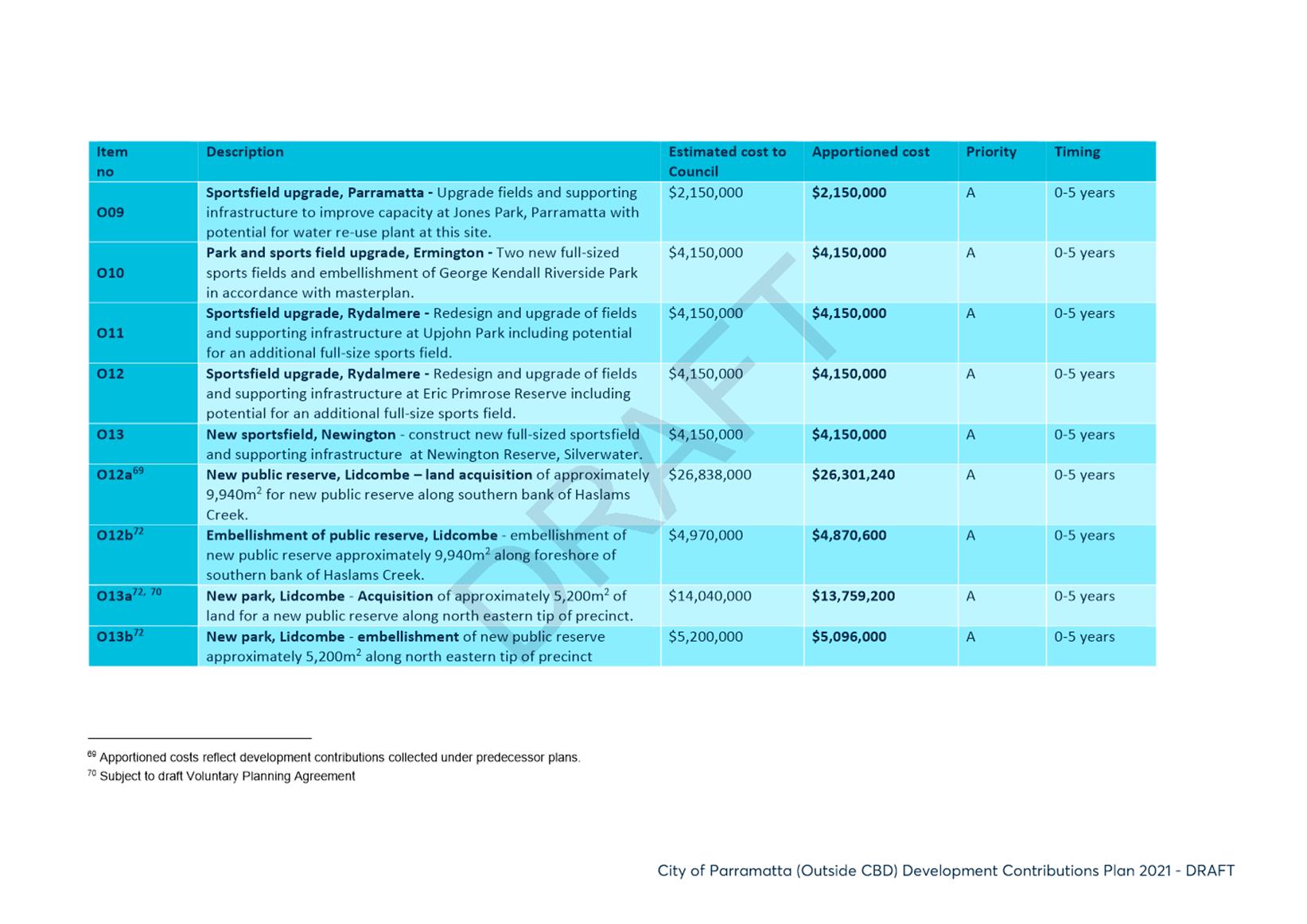
17. The below projects are 100% funded from s7.11 development contributions.
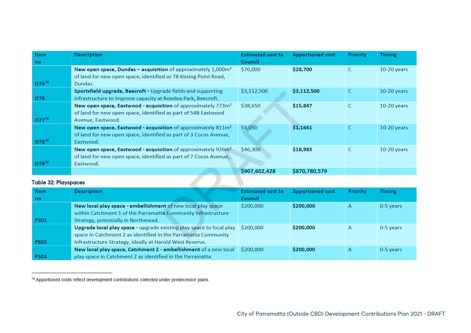
18. Pending adoption of the Draft Development Contributions Plan 2021 following its public exhibition March-April 2021, the collection of the following apportioned funds will support implementation of the Heart of Play masterplan endorsed design:
|
excerpted from Draft Development Contributions Plan 2021 |
||||
|
Appendix F, Work Program Item No. |
Description |
Apportioned Cost (,000) |
Priority |
Timing |
|
O03 |
Old Sales Yard and/or Sherwin Park |
$5,175 |
A |
0-5 years |
|
O15 |
Barton |
$2,075 |
A |
0-5 years |
|
O16 |
Doyle Ground |
$1,950 |
A |
0-5 years |
|
O17 |
PH Jeffery |
$1,038 |
A |
0-5 years |
|
|
FY 20/21 |
FY 21/22 |
FY 22/23 |
FY 23/24 |
|
Operating Result |
|
|
|
|
|
External Costs |
|
|
|
|
|
Internal Costs |
|
|
|
|
|
Depreciation |
|
|
|
|
|
Other |
|
|
|
|
|
Total Operating Result |
Nil |
|
|
|
|
|
|
|
|
|
|
Funding Source |
Nil |
|
|
|
|
|
|
|
|
|
|
CAPEX |
|
|
|
|
|
CAPEX |
|
|
|
|
|
External |
|
|
|
|
|
Internal |
|
|
|
|
|
Other |
|
|
|
|
|
Total CAPEX |
Nil |
|
|
|
|
|
|
|
|
|
|
Funding Source |
Nil |
|
|
|
Rosamund Palmer
Place Manager
Bruce Mills
Group Manager Place Services
Michael Tzimoulas
Executive Director Corporate Services
Bryan Hynes
Executive Director Property & Place
Brett Newman
Chief Executive Officer
|
1⇩ |
Attachment 1 - HoP Masterplan |
44 Pages |
|
|
2⇩ |
Attachment 2 - HoP master plan engagement report |
45 Pages |
|
|
3⇩ |
Attachment 3 - Amendments |
1 Page |
|
|
4⇩ |
Attachment 4 - Draft Sportsground Strategy and Action Plan_excerpts |
2 Pages |
|
REFERENCE MATERIAL
Thriving
12 July 2021
16.1 FOR APPROVAL: Adoption of the Hill Road Masterplan.............................. 164
Council 12 July 2021 Item 16.1
ITEM NUMBER 16.1
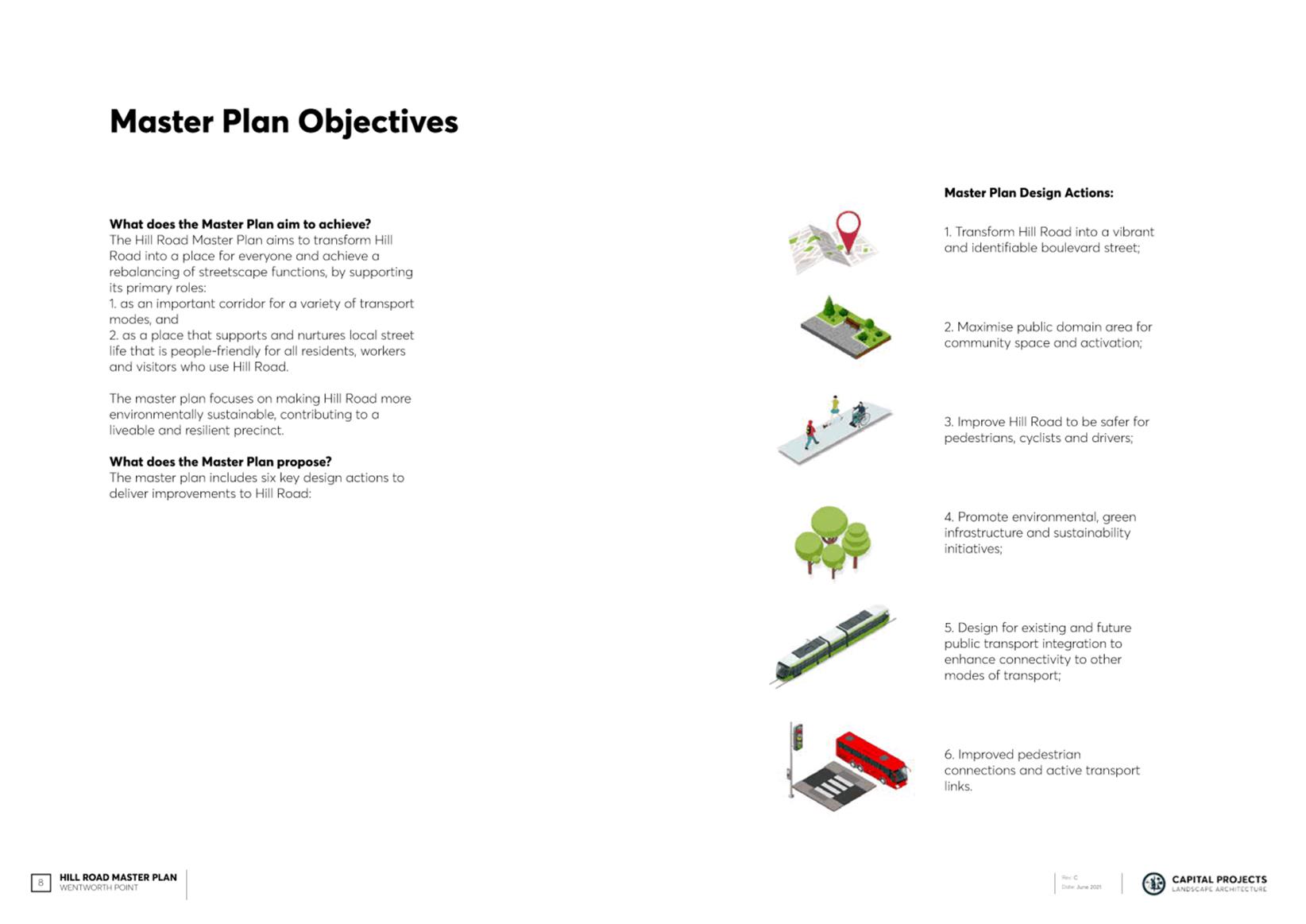
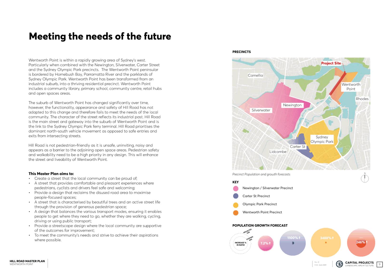
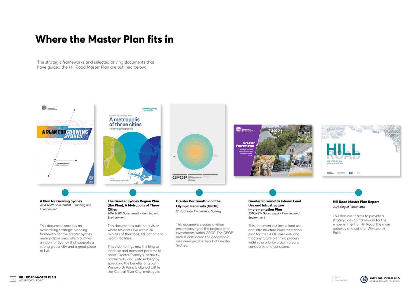
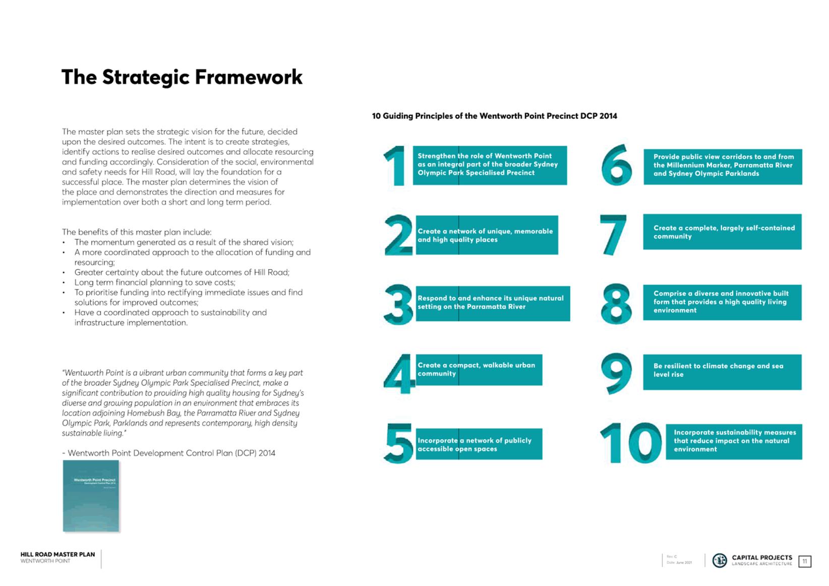
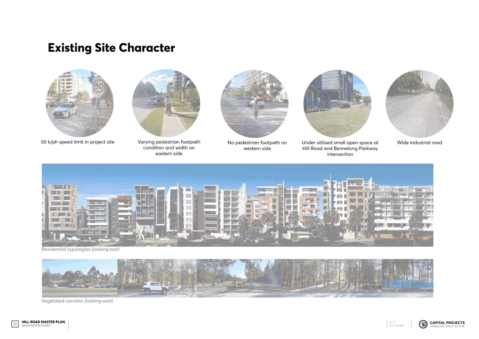
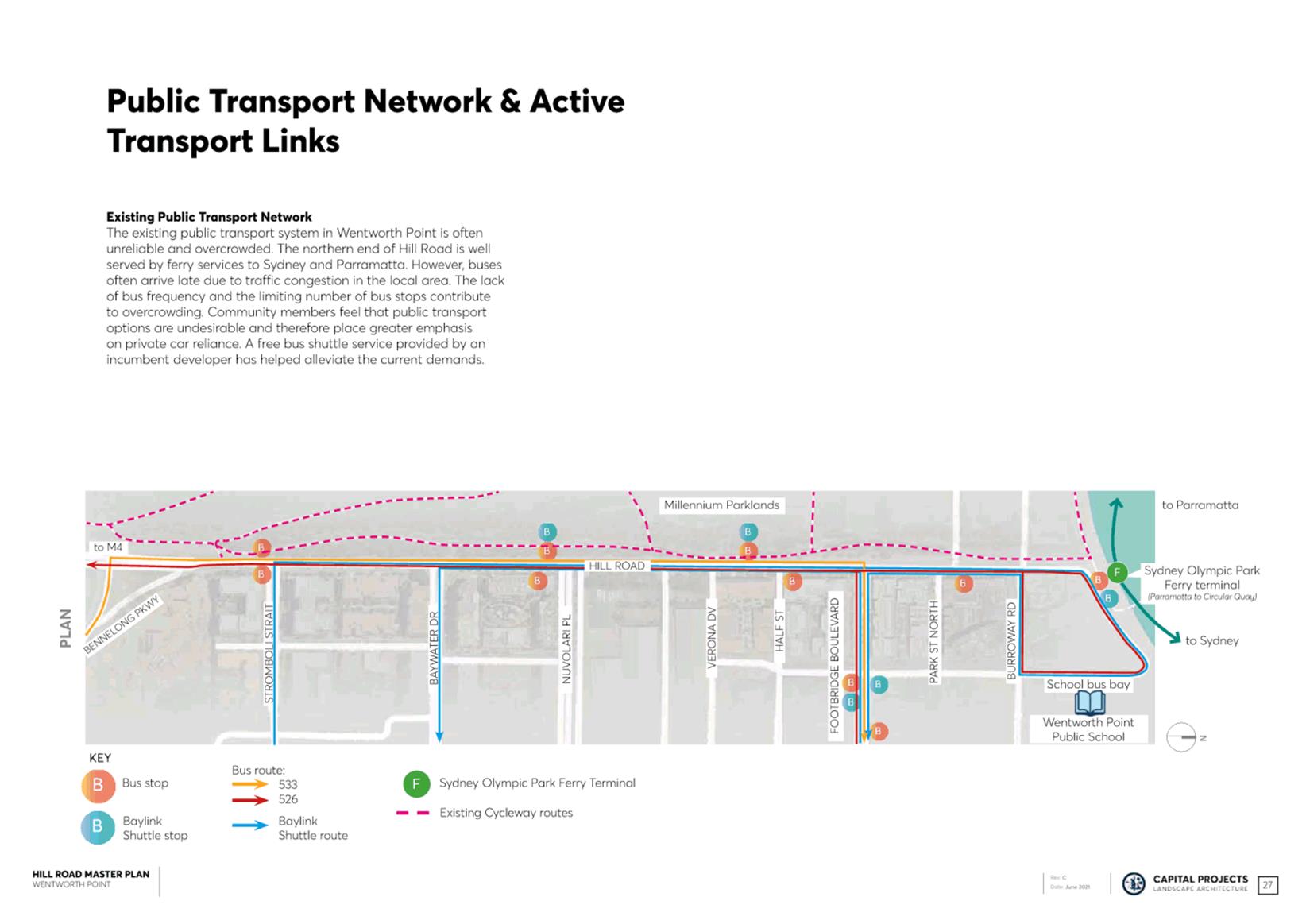
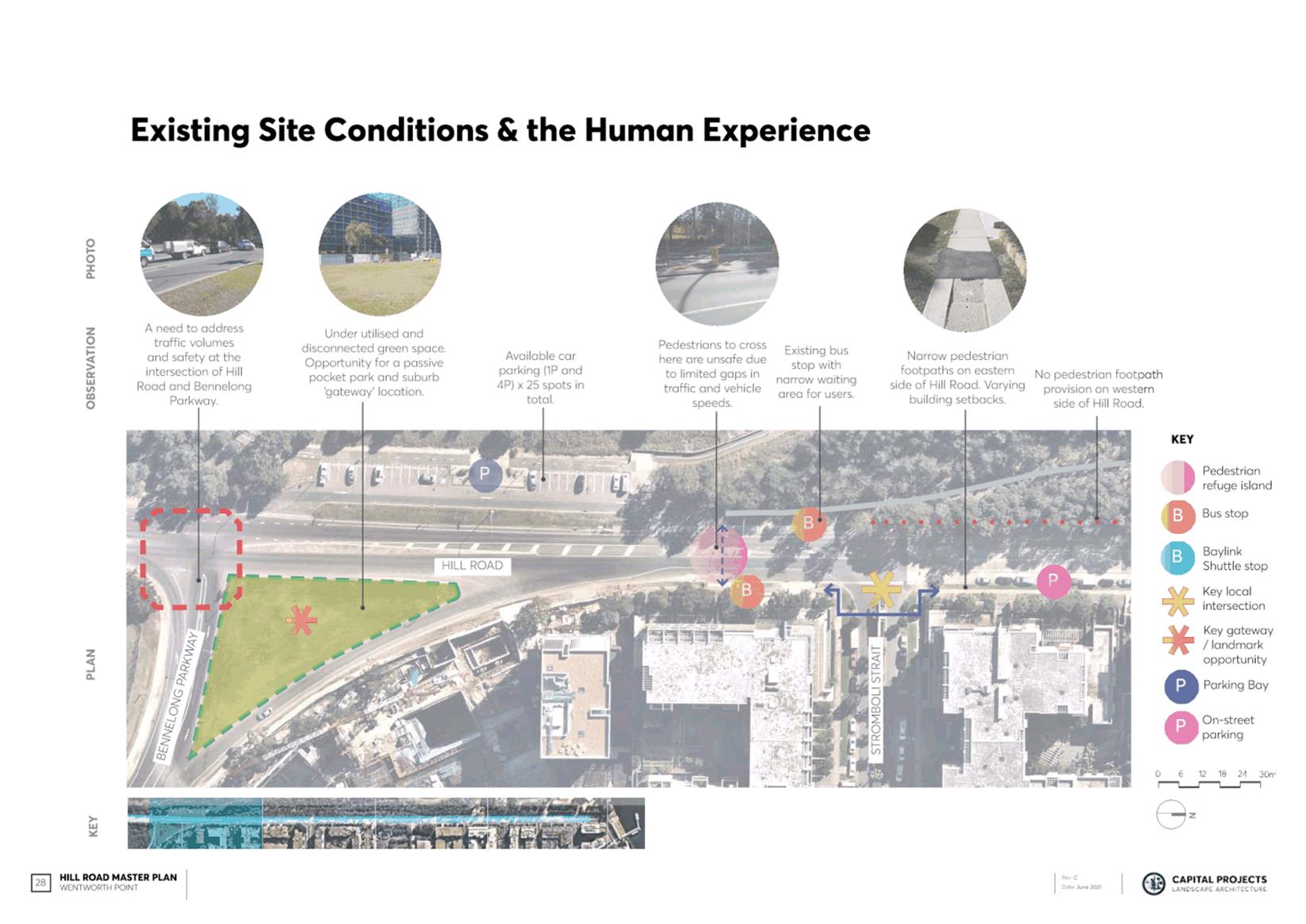
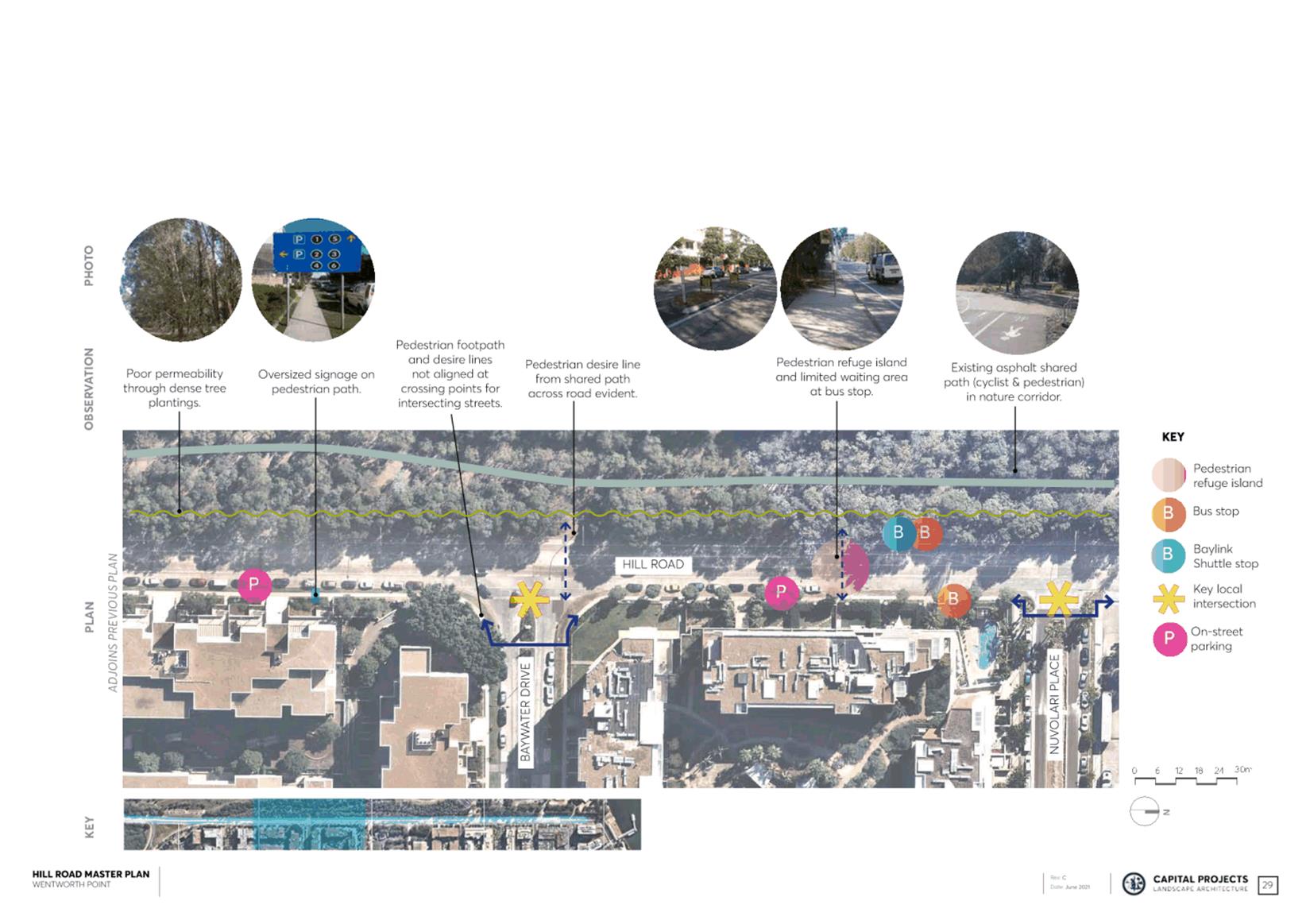
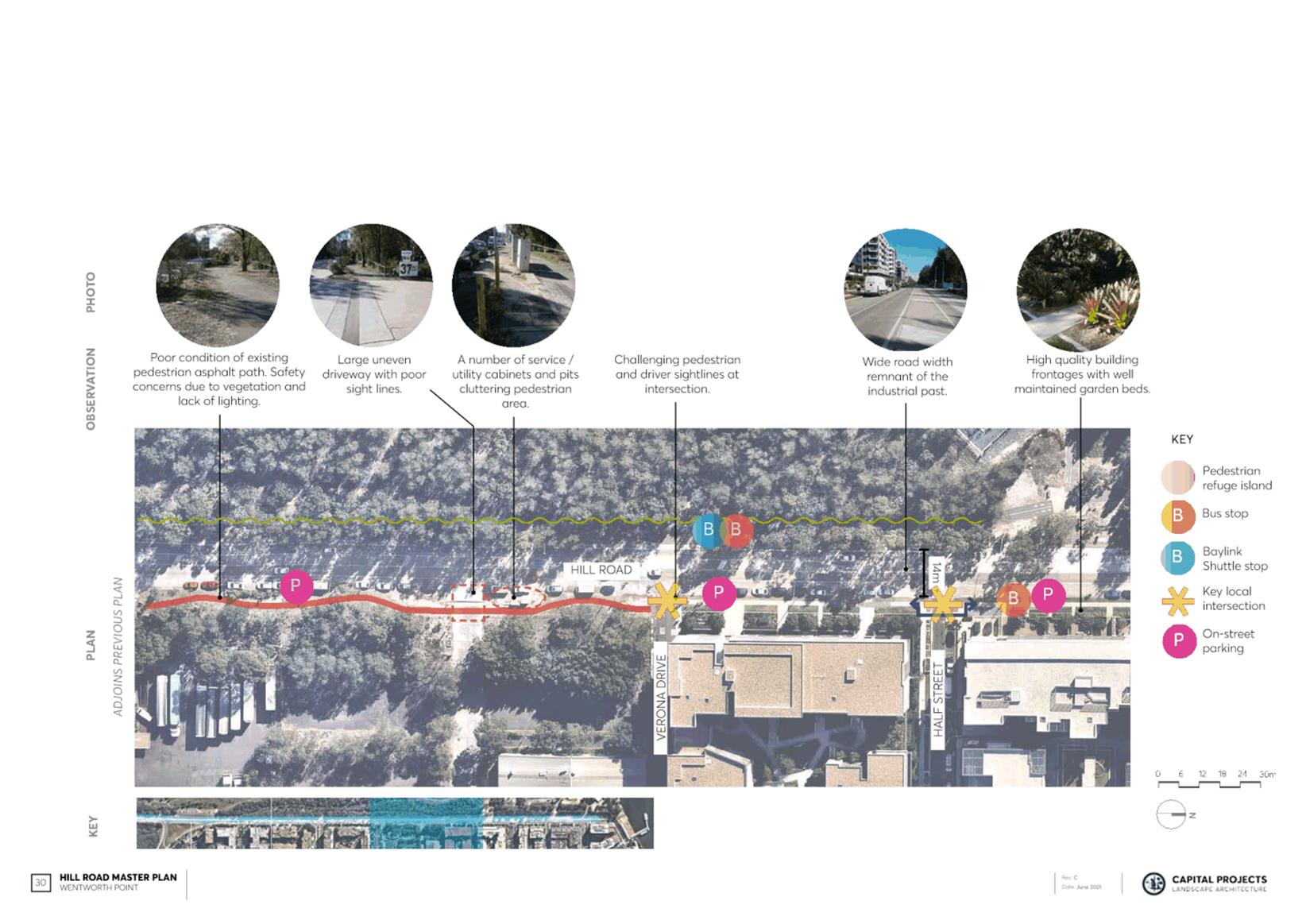
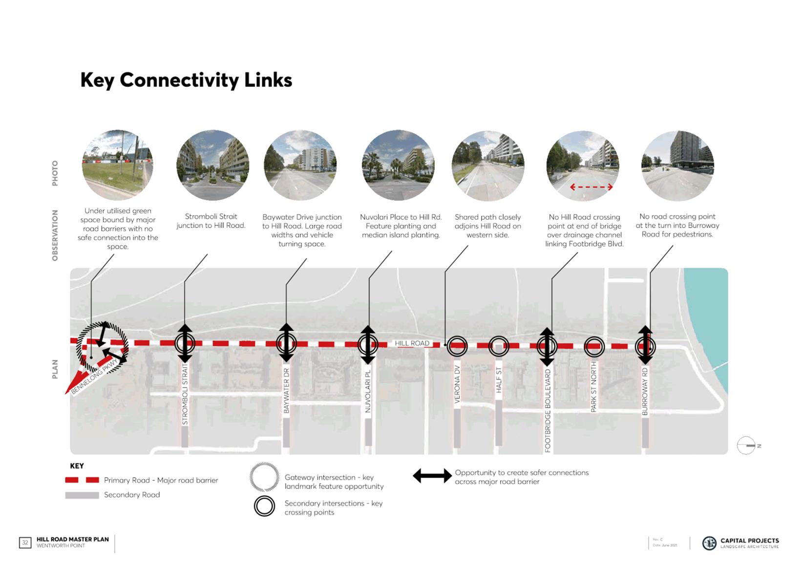
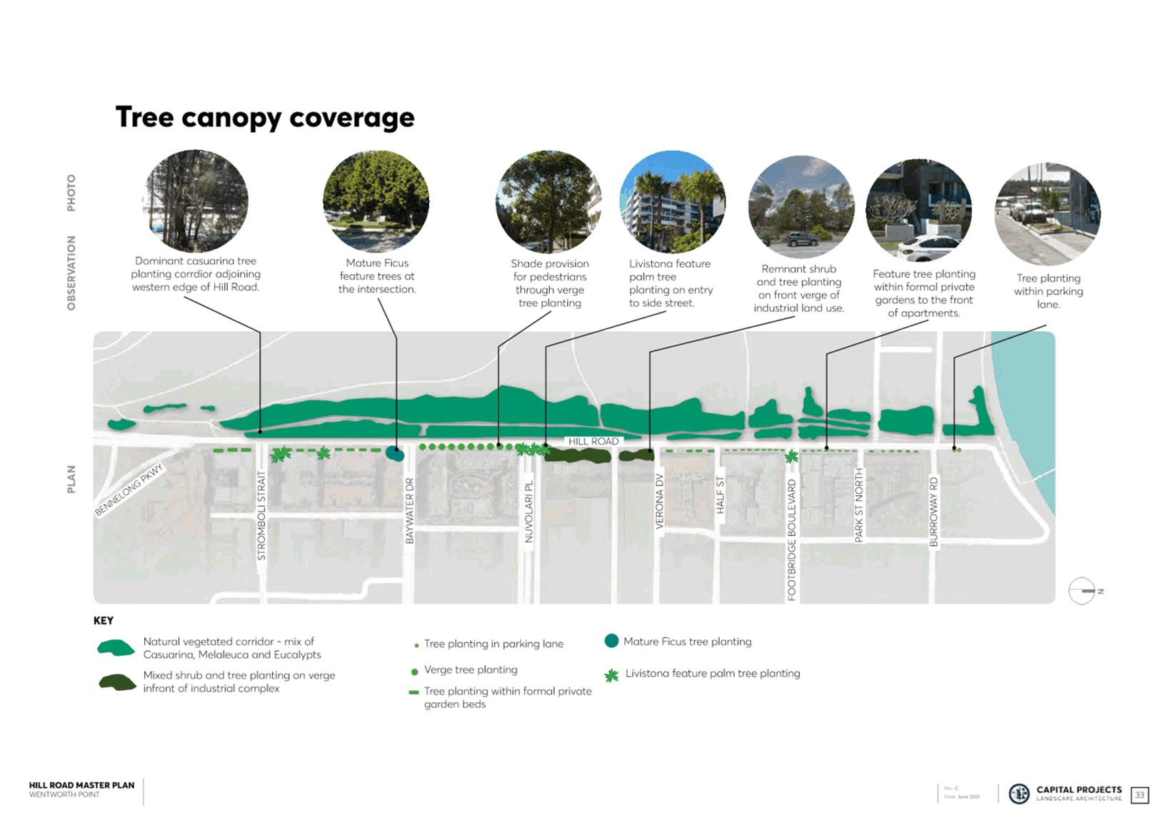
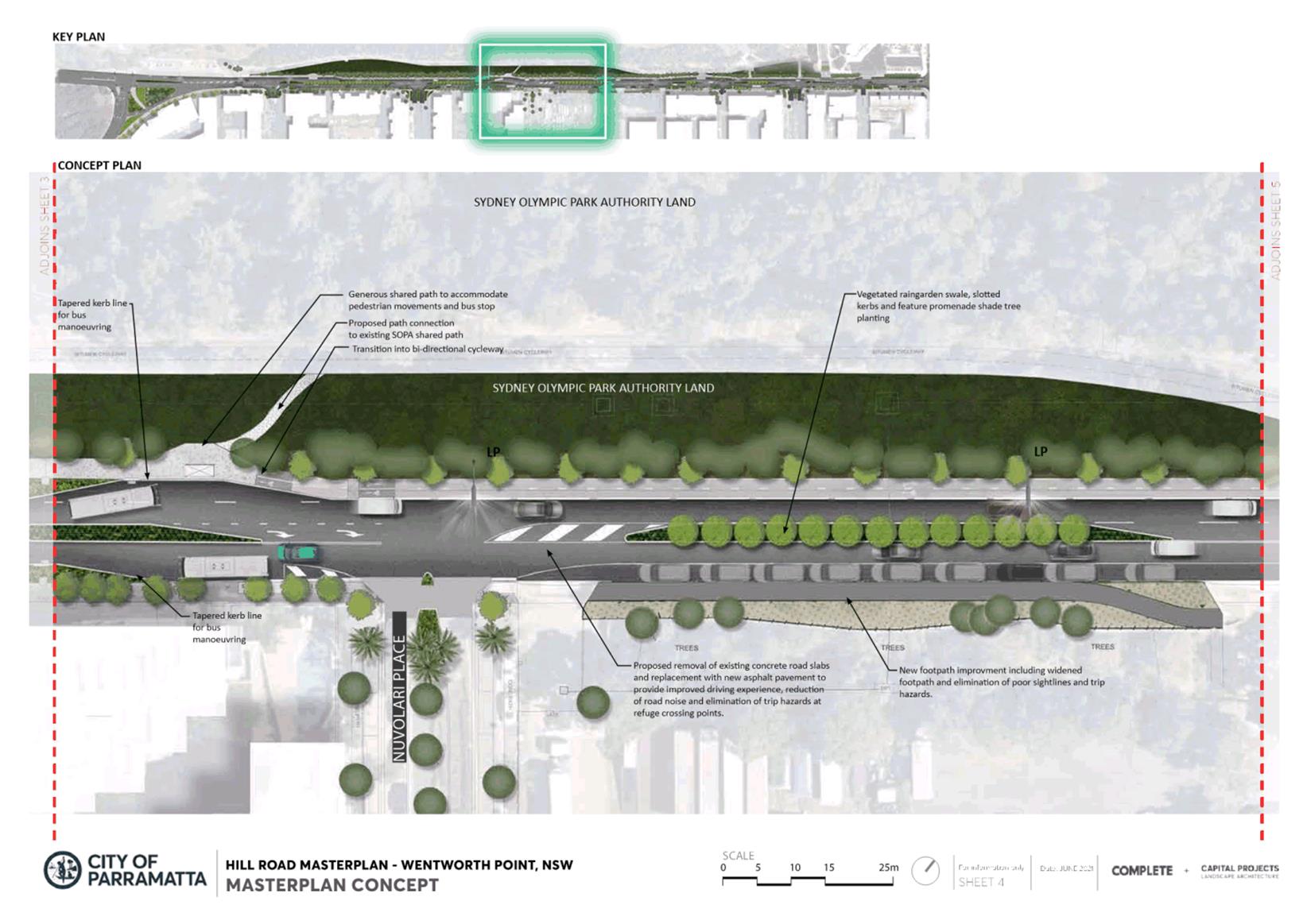
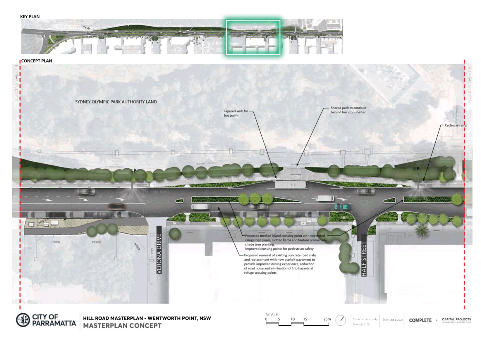
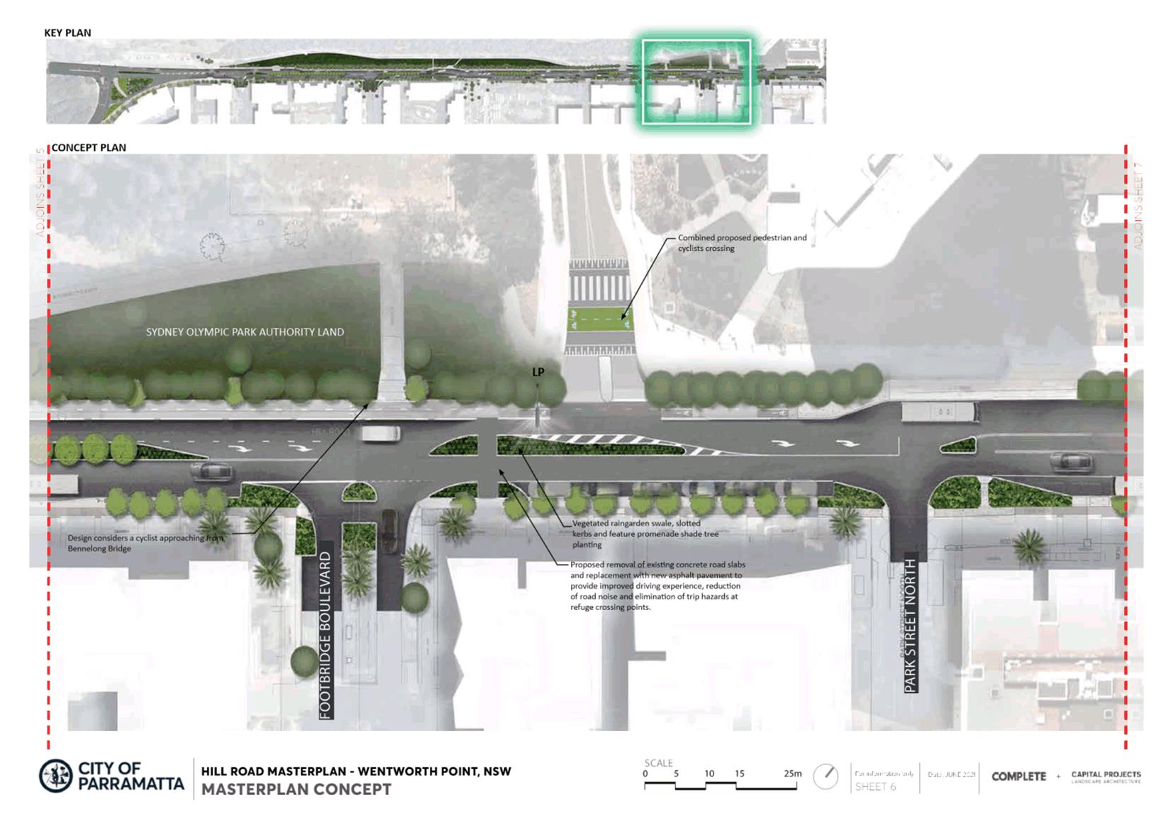
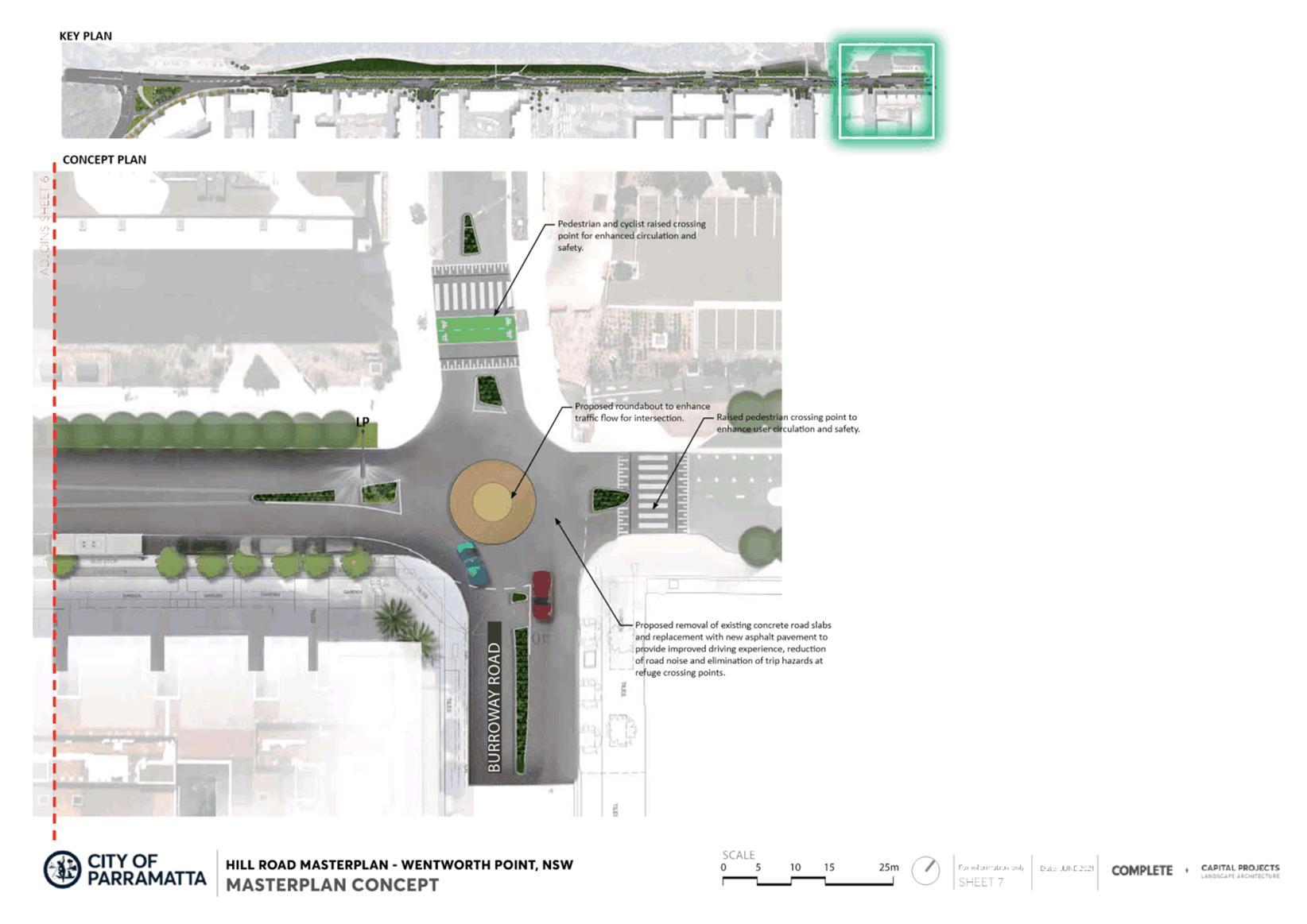
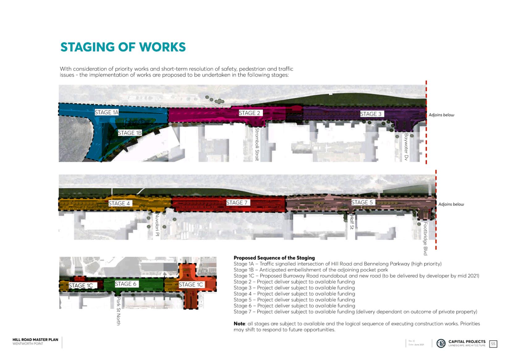
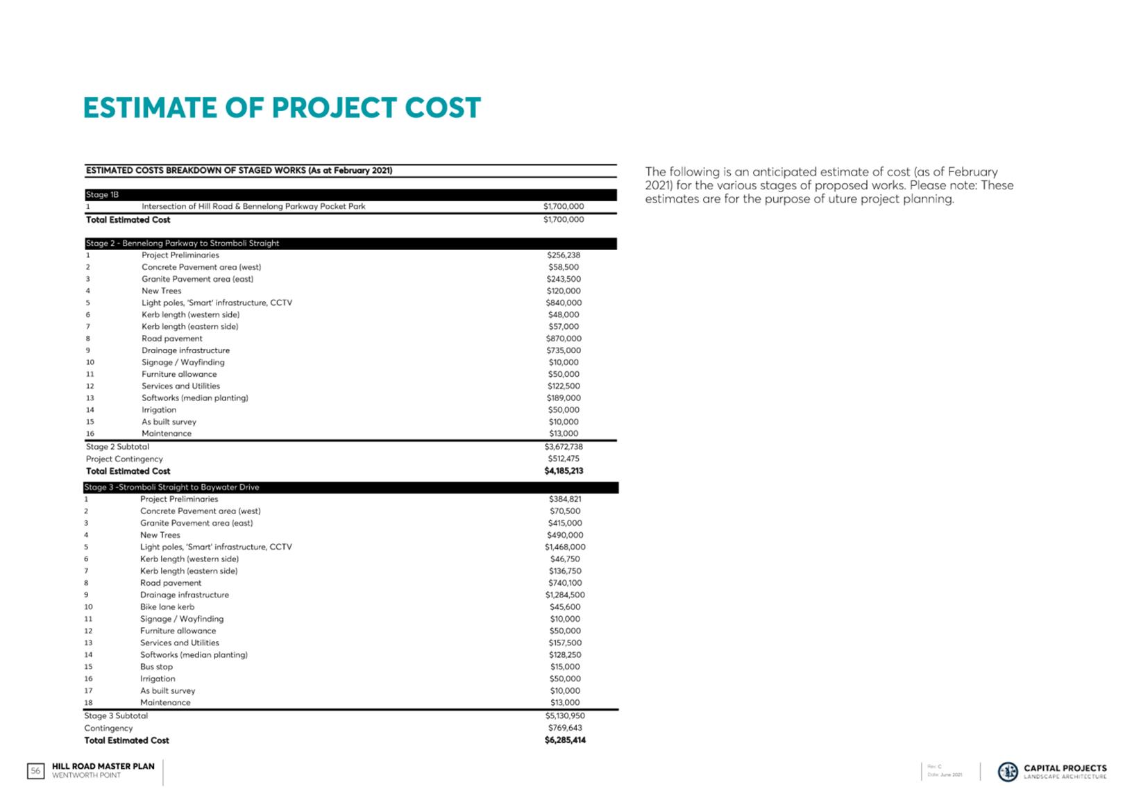
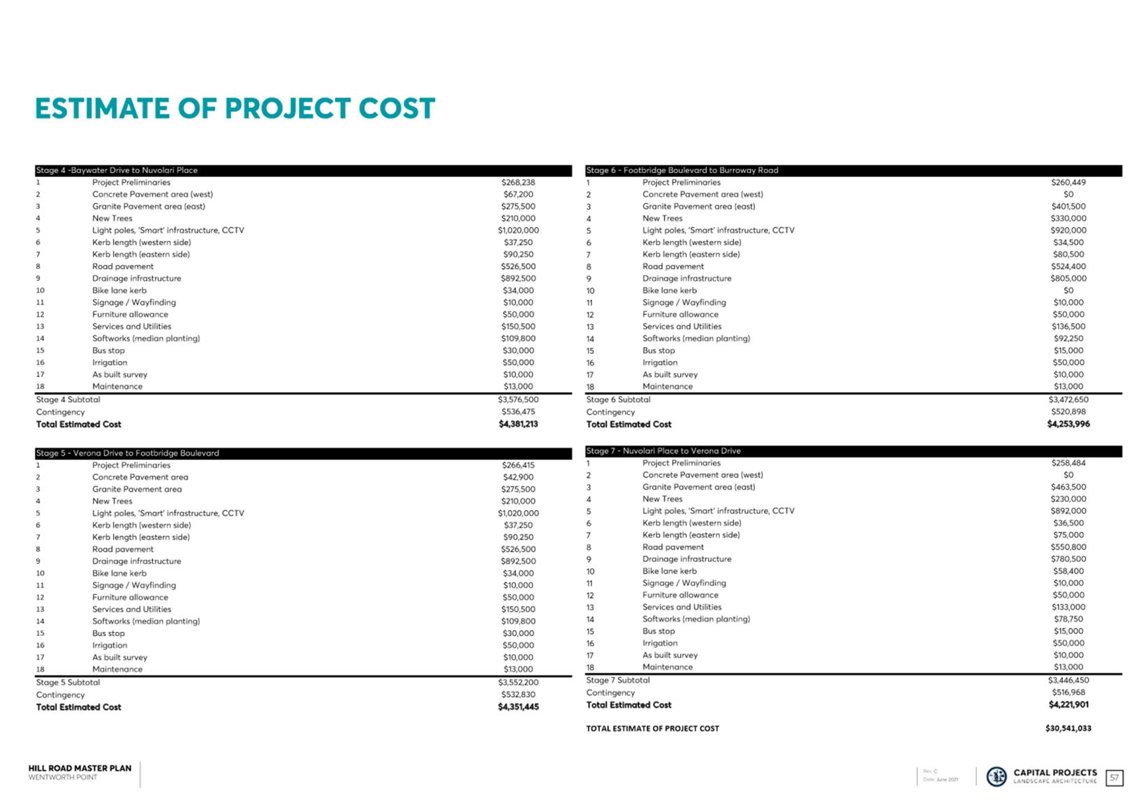
SUBJECT FOR APPROVAL: Adoption of the Hill Road Masterplan
REFERENCE F2021/00521 - D07966053
REPORT OF Place Manager
PURPOSE:
To seek adoption of the Hill Road Masterplan, which incorporates community feedback received during the public exhibition period.
(a) That Council adopts the Hill Road Masterplan as amended (Attachment 1 -Final Hill Road Masterplan) in response to submissions received during public exhibition.
(b) That copies of the adopted Hill Road Park Masterplan be made available to the public at the Wentworth Point Community Centre and Library, the City of Parramatta Library and on Council’s website.
(c) Further, that all those who provided submissions during the public exhibition period be advised of Councils decision and thanked for their contribution to the development of the Masterplan.
BACKGROUND
1. A Masterplan has been prepared for Hill Road, Wentworth Point; for the 1.13km of Hill Road starting at Bennelong Parkway and continuing to Burroway Road, Wentworth Point.
2. Hill Road, Wentworth Point is within the Rosehill Ward of City of Parramatta Council. Prior to Council amalgamation in 2016, the road was located within the former Auburn City Council local government area.
3. Hill Road is the only north-south access road into and out of Wentworth Point.
4. Buses are the main mode of public transport in the Wentworth Point area. There is ongoing community feedback that resident/workers/visitors must cross the highly trafficked Hill Road in order to reach bus stops without adequate crossings, refuge islands etc. Further, the absence of ‘bus bays’ on Hill Road results in traffic congestion when buses are picking-up/setting-down passengers.
5. Significant growth and development in Wentworth Point has also resulted in an increase in vehicle volumes.
6. The northern end of Hill Road is serviced by ferry services to Sydney and Parramatta. However, connecting buses often arrive late due to traffic congestion in the local area, particularly on Hill Road.
7. The Hill Road Masterplan seeks to identify options for enhancing safe pedestrian and vehicular flow, create a greener and more shaded roadway, and manage flood and drainage concerns.
8. The Masterplan is a holistic plan of prioritised and staged upgrades.
ISSUES/OPTIONS/CONSEQUENCES
9. The Masterplan sets a long term, high-level vision for the road corridor. Further detailed investigation and designs will commence over the next 12 - 24 months which will address key issues raised by the community including flooding and drainage concerns, traffic flow, impeded sight lines, lighting along the road and pedestrian path, and disconnected pedestrian and cycle paths.
10. The Hill Road Masterplan was informed through detailed investigation of the physical condition of the roadway, a thorough process of community consultation, and technical analysis. This investigation revealed that although Hill Road is currently regarded primarily as a movement corridor for private vehicles, it has the capacity to perform a much greater social/connectivity role if the competing priorities of the space are balanced.
11. Informed by the above, six key community-validated design principles underpin the Masterplan:
a) Transform Hill Road into an identifiable boulevard with a high quality public domain;
b) Provide a safer place for pedestrians, cyclists and road users;
c) Maximise public domain for activation, community space, social interaction and inclusion;
d) Promote environmental outcomes, urban ecology and facilitate green infrastructure;
e) Design for the integration of the proposed light rail to enhance liveability and sustainability; and,
f) Improve pedestrian connections and active transport links.
12. Noting that the Masterplan is a long-term vision, Council has invested in a $370,000 capital budget to implement short-term safety works along the roadway so that these improvements are delivered rapidly if the masterplan is adopted. This is budget is allocated as part the Draft Delivery Program 2018-2022 and Operational Plan and Budget 2021/22 (DPOP).
13. These short-term works will align with what is already in the masterplan and will improve sight lines for drivers and pedestrians, ensure compliance with disability access, better align and reduce distance of pedestrian crossing points, and increase overall safety:
- Procure a street lighting designer to ensure appropriate lux levels and coverage for cars and pedestrians along the length of the road.
- Footpath improvement works for particularly unsafe and cracked parts of the pedestrian footpath, specifically 37 – 39 Hill Road (works include demolition of existing asphalt path and garden material to be replaced with a 2.5m wide accessible path, new mulch and re-instatement of signage).
- Kerb extension and refuge island upgrade at Stromboli Street.
- Kerb extension and refuge island upgrade at Baywater Drive.
- Kerb extension at Half Street.
- Minor intersection works for Nuvolari Place.
14. The Hill Road Masterplan brings together current Council projects that relate to Hill Road in order to provide a complete and holistic representation of the long-term vision for the site.
a. The roundabout at the northern end of Hill Road, and the traffic signals at the intersection of Hill Road and Bennelong Parkway, both of which will accommodate traffic from Block H, the new Sekesui development and the TfNSW site. These elements will be delivered by Council’s Traffic and Transport and Land Use Planning teams, and will be funded through negotiated Voluntary Planning Agreements and/or s.711 contribution funds. As detailed designs progress, the aforementioned roundabout may be reconstructed as traffic signals if/when the proposed bridge over the Parramatta River is constructed.
b. Council’s Civil Infrastructure team are concurrently developing a Project Brief for the delivery of a Flood Modelling Masterplan for Hill Road to be funded out of 100330 - Drainage Improvements in Growth Areas 2021/22 Program, subject to available funding.
c. Council officers are working closely with representatives of Transport for NSW (TfNSW) to determine the overall traffic network capacity of the entire Wentworth Point Peninsula. To this end, traffic modelling work will consider the key intersections that serve Sydney Olympic Park, the Carter Street Precinct and Wentworth Point, and will include Hill Road. The future detailed design and implementation of the Hill Road Masterplan will also include consideration of traffic capacity between Bennelong Parkway and Bayswater Drive. This work will inform both current and future development proposals within the Peninsula including the existing proposals on the Block H site on Burroway Road, and the Sekisui site at 14-16 Hill Road. The modelling will assess traffic network capacity and delays on the road network up to 2036 and will include a base case that will assess traffic growth based on the existing planning controls in the Peninsula upon which any further proposals to increase development densities can be assessed accordingly. It is anticipated that the outcomes of this modelling will be reported back to Council in conjunction with the post-exhibition report for the Block H proposal in the coming months.
d. It is noted that the roundabout, the intersection, and the delivery of other stages of the Hill Road Masterplan may be affected by the recent announcement of stage 2 Parramatta Light Rail.
15. There are no other identified budgets or funding sources currently allocated for the delivery of the Hill Road Masterplan at the time of writing this Council report.
CONSULTATION & TIMING
16. The Masterplanning process commenced in 2017 but was placed ‘on-hold’ pending resolution of the proposed Parramatta Light Rail Stage 2 which was envisaged to use Hill Road as a corridor. Council is proceeding with the Hill Road Masterplan on the basis that it provides a basis for rapid short-term improvements, and in providing community-validated feedback to the NSW State Government regarding the role of Hill Road in the context of the recently announced recommencement of the Parramatta Light Rail Stage 2 works.
Stakeholder Consultation
17. The following stakeholder consultation has been undertaken in relation to this matter:
|
Date |
Stakeholder |
Stakeholder Comment |
Council Officer Response |
Responsibility |
|
Online Survey (7 – 20 November 2017) |
Community |
951 people completed the survey in full. Approx. 75% respondents drive on Hill Road daily, with traffic congestion being a major concern, along with a need for better pedestrian access and safer conditions overall. There are also concerns around flooding and drainage and improved public transport. |
Collated the feedback and add participants to a project mailing list |
Place Services |
|
5 focus groups (21 – 23 November 2017) |
Community members interested in either: Traffic and Transport, Pedestrian and Cycling, or Environment and Activation. |
Many said the turn into or off Hill Road was very difficult. There was large support for light rail. There was a need for more parking. |
Collated the feedback and add participants to a project mailing list |
Place Services |
|
Three phone interview with Mandarin speakers 14 Dec 2017 |
CALD community |
Need for additional parking |
Created a design which increased the number of parking spaces available |
Place Services |
|
Wentworth Point Working Group Meetings
6/11/2017 9/1/2018 4/9/2018 26/11/2019
|
Wentworth Point Working Group Meeting |
Concerns that the road was dangerous, and that there was no progress in fixing the issues. |
Presentation to working group on designs to date and anticipated timeline |
Place Services |
|
Public Exhibition Period (6 weeks) 18/3/21 – 26/04/21 |
Suburb of Wentworth Point |
Attachment 2 – Hill Road Masterplan Engagement report
Concerns about 2-way flow of traffic, lighting, roundabouts are a suggestions for intersections - Stromboli Strait, Baywater Drive, Nuvolari Place, continuous footpath, bi directional cycleway, improve drainage. |
Amendments to final masterplan Attachment 3 – Responses collated Hill Road Feedback
|
Place Services |
Councillor Consultation
18. The following Councillor consultation has been undertaken in relation to this matter:
|
Date |
Councillor |
Councillor Comment |
Council Officer Response |
Responsibility |
|
6 Feb, 23 April, 17 July, 28 Aug, 9 Oct, 6 Nov 2020 4 Feb 2021 11 Mar 2021 1 Apr 2021 6 May 2021 |
Rosehill Ward Councillors |
Councillor supportive of masterplan designs |
To provide regular update on the timeline of Hill Road Masterplan, the potential for short term works, and the delays caused by the uncertainty of the proposed Stage 2 of Parramatta Light Rail. |
Place Services |
LEGAL IMPLICATIONS FOR COUNCIL
19. There are no legal implications for Council associated with this report.
FINANCIAL IMPLICATIONS FOR COUNCIL
20. The short term works already have a budget of $370,000. This project and funding is available in the DPOP.
21. Printing of hard copy versions of the masterplan to be delivered to the Parramatta Library, Wentworth Point Community Centre and Library will cost approximately $200 and will be covered by Place Services Administration budget.
|
|
FY 20/21 |
FY 21/22 |
FY 22/23 |
FY 23/24 |
|
Operating Result |
|
|
|
|
|
External Costs |
|
|
|
|
|
Internal Costs |
|
|
|
|
|
Depreciation |
|
|
|
|
|
Other |
|
|
|
|
|
Total Operating Result |
Nil |
|
|
|
|
|
|
|
|
|
|
Funding Source (Place Services Admin 904000) |
NA |
|
|
|
|
|
|
|
|
|
|
CAPEX |
|
|
|
|
|
CAPEX |
|
|
|
|
|
External |
|
|
|
|
|
Internal |
|
|
|
|
|
Other |
|
|
|
|
|
Total CAPEX |
|
|
|
|
|
|
|
|
|
|
|
Funding Source |
|
|
|
|
Stephanie Cascun
Place Manager
Saniya Sharmeen
Traffic & Transport Team Leader
Bruce Mills
Group Manager Place Services
Michael Tzimoulas
Executive Director Corporate Services
David Birds
Acting Executive Director, City Planning & Design
Bryan Hynes
Executive Director Property & Place
Brett Newman
Chief Executive Officer
|
1⇩ |
Attachment 1 - HIll Road Masterplan Final |
58 Pages |
|
|
2⇩ |
Attachment 2 - Hill Road Masterplan Engagement Report |
54 Pages |
|
|
3⇩ |
Attachment 3 - Responses collated Hill Road Feedback |
2 Pages |
|
REFERENCE MATERIAL
Innovative
12 July 2021
17.1 FOR APPROVAL: Post Gateway - Draft Planning Agreement for 22 Noller Parade, Parramatta.......................... 286
17.2 FOR APPROVAL: Post Exhibition - Draft City of Parramatta (Outside CBD) Development Contributions Plan 2021................................................. 300
17.3 FOR APPROVAL: Post Exhibition - Finalisation of the Harmonisation Planning Proposal and Draft Parramatta LEP following consideration of submissions received during the public exhibition period............................... 470
Council 12 July 2021 Item 17.1
ITEM NUMBER 17.1
SUBJECT FOR APPROVAL: Post Gateway - Draft Planning Agreement for 22 Noller Parade, Parramatta
REFERENCE F2021/00521 - D08099189
REPORT OF Team Leader LUP
Applicant: Hamptons Property Services Pty Ltd
Landowner: Jimstam Holdings Pty Ltd
Development applications considered by sydney central city planning panel: Nil
workshop/briefing date: Nil
PURPOSE:
To seek Council’s endorsement of the draft Planning Agreement for the purposes of concurrent exhibition with the related Planning Proposal for 22 Noller Parade, Parramatta (RZ/15/2018).
(b) That the draft Planning Agreement be publicly exhibited concurrently with the Planning Proposal for a minimum period of 28 days and that a report be provided to Council on the outcomes of the public exhibition.
(c) Further, that Council delegate authority to the Chief Executive Officer to correct any minor inconsistencies or anomalies of an administrative nature relating to the draft Planning Agreement documentation that may arise during the drafting and exhibition process.
PLANNING PROPOSAL TIMELINE
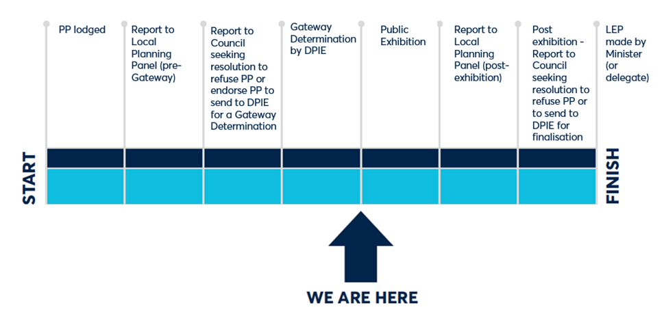
SITE DESCRIPTION
1. The subject site is located on a single lot at 22 Noller Parade, Parramatta and is shown in Figure 1 below. It has an approximate site area of 908m2 and has a legal description of Lot 1 DP 35895. The site is bound by Noller Parade to the south, Alfred Street to the east and the Parramatta River to the north.
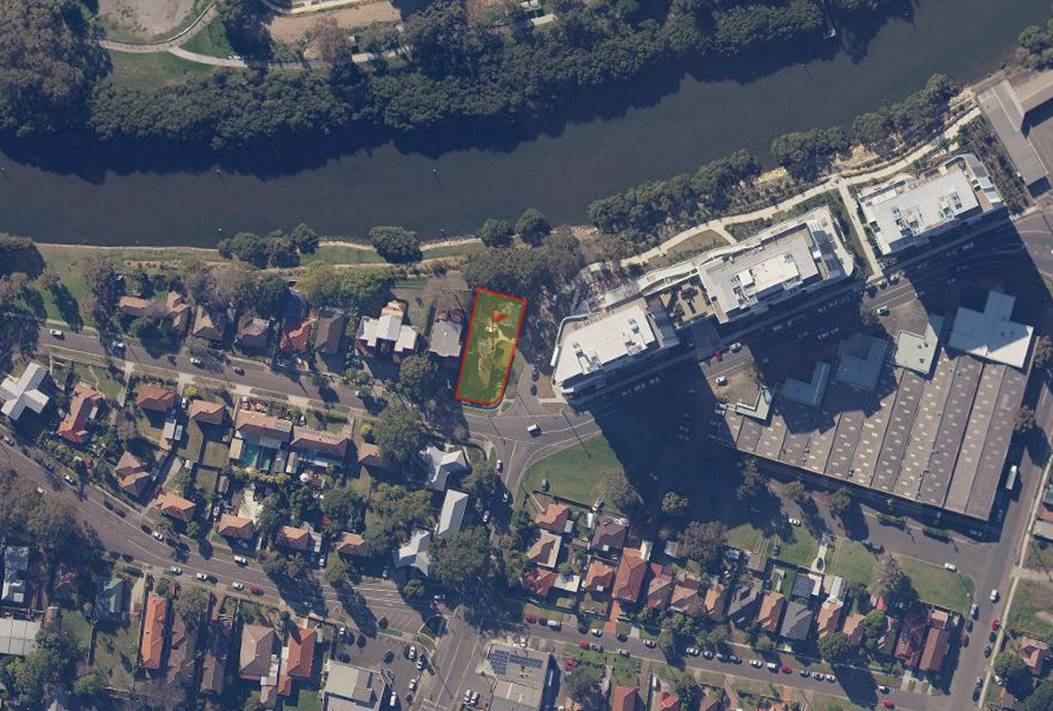
Figure 1: Locational Map
2. A single storey dwelling and detached garage are currently located on the site. The land surrounding the subject site comprises a mixture of low density residential to the south east, medium density residential to the west and south, and high density residential to the east.
3. It is noted that the adjoining properties to the west and south of the site in the R3 Medium Density Residential zone have existing 3 and 4 storey residential flat buildings. ‘Residential flat buildings’ are not permissible in this zone, however these buildings existed prior to the implementation of the Parramatta LEP 2011 and are therefore subject to existing use rights under Division 4.11 of the Environmental Planning and Assessment Act 1979 (EP&A Act).
4. Further, the property directly to the east of the site contains 13 storey mixed use development. The site’s location on a corner and the adjoining and surrounding development has resulted in it becoming isolated.
5. At its meeting on 8 October 2019, Council endorsed a Planning Proposal for the site to be submitted to the Department of Planning, Industry and Environment (DPIE) for Gateway Determination seeking the following:
a. Rezone land from R2 Low Density Residential to R4 High Density Residential
b. Increase the maximum Height of Building control from RL 14.000 to 17m (5 storeys)
c. Include a maximum floor space control of 1.5:1 (approx. 16 apartments)
6. Council also resolved at the 8 October 2019 meeting that the CEO be authorised to negotiate a Voluntary Planning Agreement on behalf of Council and that the outcome of negotiations be reported back to Council prior to its concurrent exhibition with the Planning Proposal.
7. Given the relatively minor nature of the Planning Proposal, the preparation of a site specific Development Control Plan is not proposed and any future development will be assessed under the existing provisions of the Parramatta DCP 2011.
8. A Gateway Determination was issued by DPIE on 5 December 2019 (shown in Attachment 2) and includes the following conditions:
a. That Council be authorised as the local plan making authority;
b. That the Planning Proposal be publicly exhibited for a period of at least 28 days; and
c. Consultation be carried out with the following public authorities:
i. NSW State Emergency Service
ii. Environment, Energy and Science, and
iii. NSW Heritage.
PLANNING AGREEMENT
9. At its meeting on 8 October 2019, Council resolved the following in relation to the draft planning agreement:
“(c) That the CEO be authorised to negotiate a Voluntary Planning Agreement on behalf of Council to the land value of 50% of the value uplift as per Council’s Planning Agreements Policy 2018 in addition to any development contributions payable…”
10. It is noted that the recently released Planning Agreements Practice Note (DPIE, February 2021) seeks to move away from value capture (as referred to in the above Council resolution and Planning Agreements Policy 2018) towards an infrastructure needs approach to negotiating planning agreements. It is acknowledged that while negotiations have occurred prior to the practice note being issued, the value uplift analysis detailed in this report has been used as a secondary check for the purposes of ensuring that an appropriate monetary contribution is provided towards infrastructure that will directly benefit and service the future development at the site.
11. The primary purpose of the draft Planning Agreement is therefore to provide monetary contributions towards public domain works associated with the Alfred Street Bridge which adjoins the subject site. These public domain works include upgrades to the southern entry of the Bridge at the junction of Noller Parade/Alfred Street, as well as facilitating a foreshore connection between the Alfred Street bridge and Gasworks Bridge (south side of Parramatta River).
Land Value Uplift
12. Council engaged an independent valuation consultant (BEM Property) to peer review the applicant’s valuation analysis as part of determining the value uplift referred to in Council’s resolution. The valuation details agreed between the applicant and Council officers following this review are provided in Table 2.
Table 2: Land value uplift assessment
|
Uplift Analysis |
Amount |
|
Land valuation under current controls |
$2,500,000 |
|
Land valuation under proposed controls |
$3,000,000 |
|
Relinquishment of access (at the Alfred Street frontage to facilitate public domain works associated with the Alfred Street Bridge) |
$50,000 |
|
Total Value Uplift |
$450,000 |
|
Planning Agreements Policy Minimum Requirement (50% land value uplift) |
$225,000 |
|
Current Planning Agreement Offer (50%) |
$225,000 |
13. It is noted that the Total Value Uplift ($450,000) may appear to be relatively low given the proposed rezoning from R2 Low Density Residential to R4 High Density Residential. However valuations submitted by both the applicant and peer reviewed by Council’s independent consultant confirm that the site had inherent value in its potential to be rezoned to a higher use given its attributes. The site is an isolated site that is surrounded by high density residential development (ranging from 3-4 storeys to the south and west; and 13 storey mixed use development to the east) and is also located along the Parramatta Light Rail route. These attributes have resulted in the site having a relatively high base value (under current planning controls) despite the existing R2 zoning.
14. Further, the total value uplift has also been reduced (by $50,000) as a result of the land owner relinquishing access along the Alfred Street frontage to enable closure of this portion of Alfred Street to facilitate public domain works associated with the Alfred Street Bridge landing.
Planning Agreement Offer
15. On 17 April 2021, Council received a Letter of Offer from the applicant seeking to provide Council with a monetary contribution ($225,000) to Council for the purposes of infrastructure that will benefit and service redevelopment of the subject site. Namely, the monetary contribution will assist in contributing towards the delivery of public domain works associated with, or facilitating new connections to, the future Alfred Street Bridge.
16. A revised Letter of Offer was subsequently submitted on 2 June 2021 to amend staging of this contribution in line with Council’s Planning Agreements Policy however the total monetary contribution remains unchanged.
17. It is noted that the applicant had previously proposed to carry out works adjacent to their site within Alfred Street as part of their VPA contribution towards the Alfred Street Bridge public domain works. However, Council officers have already designed the proposed public domain works at the southern entry of the Alfred Street Bridge and would therefore prefer a monetary contribution towards these works, including facilitating future connections to the bridge to ensure these works are undertaken in a coordinated manner.
18. Location of works and concept plans detailed below:
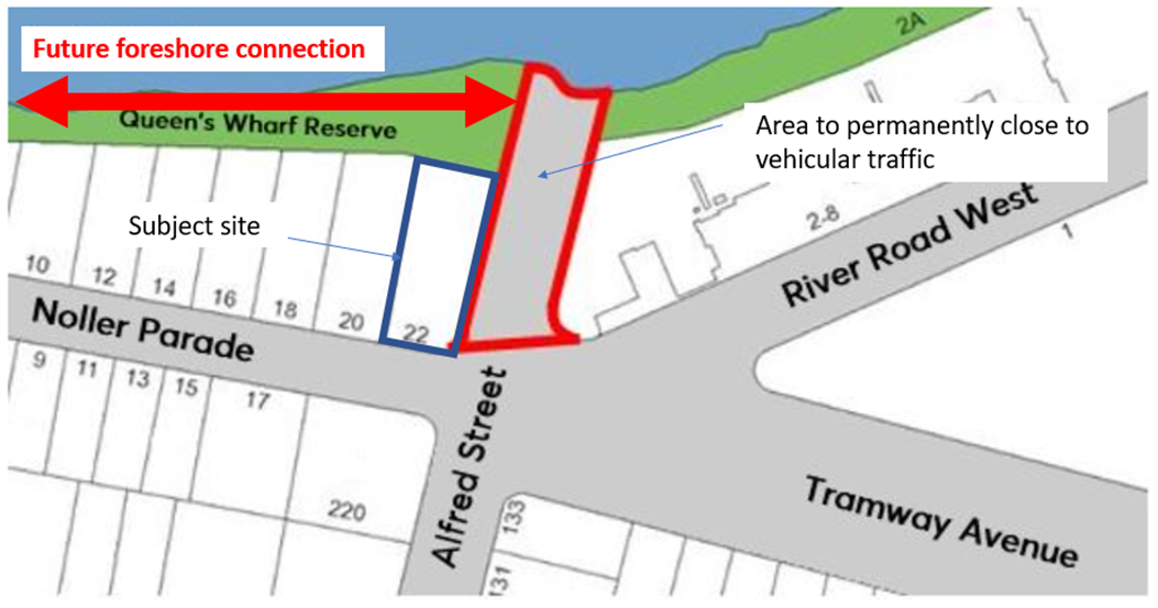
Figure 2: Map showing area of Alfred Street to be closed including future foreshore connection
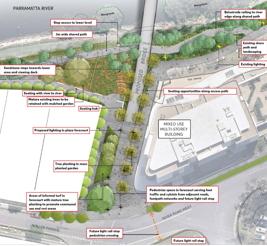
Figure 3: Alfred Street Concept Plan
19. The Planning Agreement Offer is provided in Attachment 1 with the key matters detailed in Table 3 below.
Table 3: Summary of Planning Agreement Offer
|
|
Item |
Costs for Planning Agreement |
Value attributing public benefit |
|
1. |
Monetary contribution towards Public Domain works associated with, or new connections to, the Alfred Street Bridge. |
$225,000 |
$225,000 |
|
2. |
Relinquishment of access (at the Alfred Street frontage to facilitate public domain works associated with the Alfred Street Bridge) |
Nil cost attributed in VPA |
Nil cost attributed in VPA (however value uplift analysis considers impact of loss of access on land values) |
|
Staging |
75% of the monetary contribution prior to the issue of a Construction Certificate (CC) 25% of the monetary contribution prior to the issue of any occupation certificate (OC) (interim or final) |
Yes |
Yes |
|
Security |
Bank Guarantees could be alternatively provided |
Yes |
Yes |
|
Costs |
Applicant agrees to pay Council’s legal costs |
Yes |
N/A |
|
Other |
Section 7.11, 7.12, and 7.24 contributions apply |
Yes |
N/A |
|
|
Total |
$225,000 |
$225,000 |
20. Items relating to monetary contributions (or alternative bank guarantees) will be subject to indexation to reflect increases in the Consumer Price Index between the execution of the agreement and timing payments as required by Part 5.11 of Council’s Planning Agreements Policy.
21. It is recommended that the CEO be granted delegated authority to finalise the legal drafting of the planning agreement on behalf of Council. Should Council resolve to endorse the draft Planning Agreement offer, a draft legal agreement and explanatory note will be prepared for the purposes of a concurrent public exhibition with the associated planning proposal for the site.
CONSULTATION & TIMING
22. Pending Council’s resolution on this matter, the draft Planning Agreement will be publicly exhibited. The exhibition will be conducted in accordance with the Gateway determination and the requirements of the Environmental Planning and Assessment Act 1979. The outcome of the public exhibition will then be reported to Council with a view to finalising the Planning Proposal and Planning Agreement.
Stakeholder Consultation
23. The following stakeholder consultation has been undertaken in relation to this matter:
|
Date |
Stakeholder |
Stakeholder Comment |
Council Officer Response |
Responsibility |
|
21 May 2021/24 May 2021 |
Property Development Group |
No objections raised to VPA offer |
No further action required. |
City Planning |
|
10 June 2021/11 June 2021 |
Senior Transport Planner |
No objections raised to VPA. Advice provided that monetary contributions could also contribute toward facilitating future connection to Alfred Street Bridge along the foreshore (to the rear of the site) from Gasworks Bridge. |
No further action required. |
City Planning |
Councilor Consultation
24. No previous Councillor consultation has been carried out in relation to the outcomes of the Planning Agreement negotiations since the previous report to Council on the Planning Proposal for this site. Councilors were advised of the parameters of this negotiation as part of that previous report considered on 8 October 2019.
FINANCIAL IMPLICATION FOR COUNCIL
25. If Council resolves to approve this report in accordance with the recommendation, Council will receive a monetary contribution of $225,000 should a residential development proceed. This contribution is not included in the current adopted four-year budget and if resolved, will be included within the budget process or as part of the quarterly review.
26. The monetary contribution in the Planning Agreement would be delivered in addition to development contributions payable with respect to any redevelopment of the site. The costs of registering the agreement and associated easements on the title of land and transfer of monetary contribution or bank guarantee will be paid by the applicant.
27. The monetary contribution will be staged with 75% of the monetary value prior to issue of Construction Certificate. The remaining 25% will be paid prior to issue of any Occupation Certificate.
28. The table below represents the estimated timing of the monetary contribution to be received if Council resolves to approve this report.
|
|
FY 20/21 |
FY 21/22 |
FY 22/23 |
FY 23/24 |
F24/25 |
|
Revenue Contribution |
|
$168,750 (75%) |
$56,250 (25%) |
|
|
|
|
|
|
|
|
|
|
|
|
|
|
|
|
|
Operating Result |
|
|
|
|
|
|
External Costs |
|
|
|
|
|
|
Internal Costs |
|
|
|
|
|
|
Depreciation |
|
|
|
|
|
|
Other |
|
|
|
|
|
|
Total Operating Result |
|
|
|
|
|
|
Funding Source |
|
|
VPA Contribution |
General revenue |
General revenue |
|
|
|
|
|
|
|
|
CAPEX |
|
|
|
|
|
|
CAPEX |
|
|
|
|
|
|
External |
|
|
|
|
|
|
Internal |
|
|
|
|
|
|
Other |
|
|
|
|
|
|
Total CAPEX |
|
|
|
|
|
|
Funding Source |
|
|
|
|
|
29. The costs associated with the preparation, exhibition and finalisation of the draft Planning Agreement involve internal resources and legal costs. The developer will reimburse any legal costs relating to the VPA, which will then result in nil cost to Council for this item.
Conclusion
30. It is recommended that Council endorse the Draft Planning Agreement Offer for 22 Noller Parade, Parramatta and that the Chief Executive Officer be authorised to prepare the legal drafting in accordance with the Letter of Offer provided in Attachment 1 on behalf of Council for the purpose of public exhibition.
31. If endorsed, the draft Planning Agreement will be publicly exhibited concurrently with the Planning Proposal for 22 Noller Parade, Parramatta for a minimum of 28 days. A further report will be prepared for Council on the outcome of the public exhibition period.
Kevin Kuo
Team Leader LUP
Michael Rogers
Land Use Planning Manager
Robert Cologna
Acting Group Manager, City Planning
Michael Tzimoulas
Executive Director Corporate Services
David Birds
Acting Executive Director, City Planning & Design
Brett Newman
Chief Executive Officer
|
1⇩ |
Letter of Offer (dated 2 June 2021) |
3 Pages |
|
|
2⇩ |
Gateway Determination - 22 Noller Parade, Parramatta |
2 Pages |
|
REFERENCE MATERIAL
ITEM NUMBER 17.2
SUBJECT FOR APPROVAL: Post Exhibition - Draft City of Parramatta (Outside CBD) Development Contributions Plan 2021
REFERENCE F2019/00796 - D08093512
REPORT OF Team Leader Land Use Planning
workshop/briefing date:
7 June and 7 July 2021.
PURPOSE:
Council to consider the outcomes of the public exhibition of the Draft Parramatta (Outside CBD) Development Contributions Plan 2021 and to seek Council’s endorsement for finalisation of the Plan.
(a) That Council receives and notes the submissions made during the public exhibition of the “Draft City of Parramatta (Outside CBD) Development Contributions Plan 2021” – a summary of submissions is provided at Attachment 1.
(b) That Council endorses the Draft City of Parramatta (Outside CBD) Development Contributions Plan 2021 [Attachment 2] for finalisation with the following amendments:
(i) The addition of ‘“affordable housing or social housing by a social housing provider. If the development is mixed use, only the affordable housing/social housing component will be excluded” as development which is exempted from this Plan, and associated amendments to Section 1.3 of the Plan to support this addition.
(ii) Amend works program item C02 (new local community facility, Epping) to remove reference to location of Chambers Court to not have a specified location consistent with Council’s resolution of 9 July 2018.
(iii) Amend works program item C01 (new hub, Epping) to change the timing for the new hub from 0 to 5 years to 0 to 10 years to align with the Civic Plaza timing and better reflect the project’s complexity.
(iv) Various other administrative or minor changes as outlined in Table 5 of this report.
(c) That Council endorse the Plan to come into effect within 8 weeks from the date of the public notice of Council’s decision to allow sufficient time to incorporate the final Plan in Council’s systems and processes.
(d) That Council authorises the Chief Executive Officer to make any minor amendments and corrections of a non-policy and administrative nature that may arise during the Draft City of Parramatta (Outside CBD) Development Contributions Plan 2021 finalisation process.
(e) Further that, Council authorise the Chief Executive Officer, on behalf of Council, to amend the following Council-endorsed planning agreements for the purposes of public re-exhibition (if required), in order to include provisions which require any future development approvals granted on the associated land to contribute the equivalent to what they would have paid under current development contributions plans in lieu of any other development contribution requirement that may be in place at the time the approval is granted, as follows:
(i) Amendment of the planning agreement for 14-16 Hill Road, Sydney Olympic Park with Sekisui House Australia Pty Ltd and SH Hill Road Development Pty Ltd to include the application of equivalent rates contained within the Auburn Development Contributions Plan 2007 (Amendment No. 1); and
(ii) Amendment of the planning agreement for 38-42, 44 and 44A Wharf Road, Melrose Park, 657 Victoria Road, Melrose Park and 27-29 Hughes Avenue, Ermington with Payce MP2 Pty Ltd and associated parties to include the application of equivalent rates contained within Parramatta Section 94A Development Contributions Plan (Amendment No. 5) 2017.
and that the outcomes of the re-exhibition will be reported to Council.
BACKGROUND
1. At its meeting of 30 November 2020, Council endorsed the Draft City of Parramatta (Outside CBD) Development Contributions Plan 2021” (Draft Plan) for public exhibition as follows:
“(a) That Council approve the “Draft City of Parramatta (Outside CBD) Development Contributions Plan 2021” (Draft Plan) at Attachment 1 for the purposes of public exhibition for a minimum period of 28 days.
(b) That a report on the outcomes of the public exhibition be provided to Council prior to finalisation of the Draft Plan.”
2. The preparation of the Draft Plan is a key component of the “Harmonisation Project”, which also seeks to create a single consolidated local environmental plan and development control plan for the LGA.
3. As a result of NSW Government changes to council boundaries in May 2016, eight separate development contributions plans currently apply to areas in the LGA outside the Parramatta CBD and Sydney Olympic Park (refer Figure 1). The current plans are also more than 10 years old and no longer fully reflect current population projections, infrastructure demand and costs, or Council's current infrastructure priorities.
4. Current Council strategies, including the Local Strategic Planning Statement (2020) and Community Infrastructure Strategy (2020), forecast significant population growth in the City of Parramatta LGA. The area outside the Parramatta CBD and Sydney Olympic Park will grow by approximately 166,839 new residents and 33,131 new workers between 2021 and 2041. This is a comparatively high rate of growth compared to other council areas in NSW.
5. This new population will use local infrastructure and contribute to demand for its use. This local infrastructure includes open space, recreation facilities, community facilities such as libraries, and traffic and transport works.
6. It is noted that the development contributions framework applying to land inside the CBD is being reviewed separately in connection with the Parramatta CBD Planning Proposal. Sydney Olympic Park is also excluded as this area falls outside Council’s land use jurisdiction.
Overview - Draft Plan
7. The exhibited Draft Plan will replace all existing contributions plans that apply outside the Parramatta CBD and Sydney Olympic Park with a single, consolidated section 7.11 nexus-based plan. A section 7.11 plan is proposed instead of a 1 per cent fixed-rate section 7.12 plan as it will deliver a higher share of the costs of infrastructure required as a result of the significant development forecast.
Population forecasts
8. The Draft Plan includes updated population forecasts. All development contributions plans include population forecasts, as the forecasts are the key indicator of anticipated development and associated infrastructure demand and cost.
9. The Draft Plan is based on forecast development and associated infrastructure demand during the 20-year period from 2021 to 2041.
10. Council’s Community Infrastructure Strategy, adopted by Council in July 2020, forecasts an additional 253,000 people will live in the City of Parramatta LGA by 2041. Of this, 66 per cent of this growth, or 166,839 residents, is forecast in the area where the Draft Plan will apply. The remaining balance is forecast to be located in the Parramatta CBD and Sydney Olympic Park.
11. In addition, 33,131 workers and 2,306 visitors are forecast in the Draft Plan area between 2021 and 2041. It is anticipated that the economic impacts of the COVID-19 pandemic will only impact on development and subsequent rates of population growth in the short term, without impacting on long term population forecasts.
Updated works program
12. Contributions plans include a works program, which identifies the infrastructure required to meet the needs of the forecast development and an estimate of the timeframe within which it will be delivered. The works program also includes an estimate of the capital costs to Council of building each infrastructure item, and the share of costs that the plan seeks to recover through development contributions (known as ‘apportionment’).
13. The Draft Plan’s works program reflects Council’s current strategic infrastructure priorities. Infrastructure items identified in the Draft Plan have been drawn from existing Council plans and strategies that identify infrastructure needs, including:
· Community Infrastructure Strategy;
· Parramatta Bike Plan;
· Parramatta Ways Walking Strategy;
· Road network improvement projects identified by the Traffic Engineering and Advisory Group;
· Projects identified through growth precinct strategic planning; and
· Projects identified in existing plans, which remain consistent with identified needs.
14. The Draft Plan’s works program (detailed in Appendix F of the Draft Plan provided at Attachment 2) has an estimated capital cost to Council of $1.69 billion over 20 years (2020 costs). A breakdown of the costs is provided at Table 1.
Table 1: Draft Plan works program cost and cost apportioned to development
|
Infrastructure works category |
Estimated cost |
Cost apportioned to development |
|
Community facilities |
$252.8M |
$101.0M |
|
Recreation facilities – aquatic facilities |
$47.0M* |
$23.5M |
|
Recreational facilities – open space/outdoor |
$924.1M |
$887.1M |
|
Recreational facilities – indoor recreation |
$153.7M |
$76.9M |
|
Traffic and transport |
$301.0M |
$287.8M |
|
Plan administration costs |
$14.9M |
$14.9M |
|
Total (approx.) |
$1.69B |
$1.39B |
*Covers Epping and Parramatta aquatic facilities. Balance of costs to Council, excluding costs for which funding has already been confirmed through State Government grants/funding.
15. The Draft Plan works program has been prepared in accordance with key legal requirements underpinning section 7.11 plans of ‘nexus’ and ‘apportionment’. Nexus refers to the connection between development and identified infrastructure – only projects which can be demonstrated to meet a need created by future development can be included in the Draft Plan.
16. ‘Apportionment’ refers to the share of infrastructure costs that can be recovered through development contributions – this needs to be proportionate to the extent to which a works item is required to serve the demand created by new development.
Contribution rates
17. The Draft Plan includes updated contribution rates that will replace the existing plans’ various contribution rates as shown in Figure 1 and detailed in Table 2.
Figure 1: Current applicable Plans in the City of Parramatta LGA.
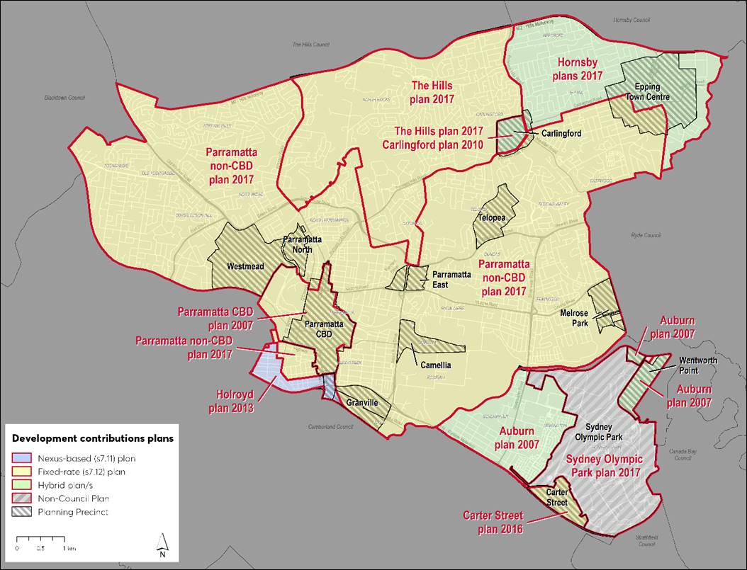
Table 2: Current Plans contribution rates, 2-bedroom dwellings
|
Plan Type |
Contributions rate |
Equivalent rate ($/dwelling) |
|
|
Development Contributions Plans (formerly Hornsby LGA land and Epping Town Centre) Plan 2017 |
s7.11/s7.12 |
$15,892 |
$15,892 |
|
Holroyd Plan 2013 – Mays Hill Centre |
s7.11 |
$14,477 |
$14,477 |
|
Contributions Plan 14 - Carlingford Precinct 2010 |
s7.11/s7.12 |
$14,391 |
$14,391 |
|
Holroyd Plan 2013 – Infill |
s7.11 |
$8,866 |
$8,866 |
|
Auburn Plan 2007 |
s7.11/s7.12 |
$6,373 |
$6,373 |
|
Carter Street Precinct Plan 2016 |
s7.12 |
1% of development cost |
$3,759* |
|
Parramatta Section 94A Development Contributions Plan (Amendment No. 5) 2017 |
s7.12 |
1% of development cost |
$3,077* |
|
Development Contributions Plan (former Hills LGA land) Plan 2017 |
S7.12 |
1% of development cost |
$2,412* |
*Estimated by Council Officers based on an analysis of development applications and associated development costs.
18. Contribution rates are specified in section 2.1 of the Draft Plan (at Attachment 2) and an extract provided below Figure 2.
Figure 2: Contributions rates - Draft City of Parramatta (Outside CBD) Development Contributions Plan 2021 (Extract Table 3 from the Draft Plan)
19. Contribution rates are determined based on the infrastructure costs that can be reasonably apportioned to development. The contribution payable by a particular development is calculated by multiplying the population increase that will arise from the development by the applicable contribution rate.
20. The Draft Plan proposes rates comparable to those already paid in some existing plans, such as those around the Carlingford train station (formerly part of The Hills Council) and land formerly part of Hornsby Council. In other areas like the Carter Street precinct, existing residential contribution rates are low and do not reflect current land values and infrastructure costs.
21. A chart comparing contribution rates for 2-bedroom dwellings in existing plans, the Draft Plan and other various other councils’ plans is shown in Figure 3 below. Rates for 2-bedroom dwellings are the most pertinent comparator as this will be the most common number of bedrooms in new residential development.
22. The Draft Plan’s proposed rates are also comparable to rates currently being charged by many neighbouring and high growth councils in Sydney, including Cumberland City Council, which recently adopted its own harmonised development contributions plan.
23. The Draft Plan does not propose to exceed contribution caps imposed by the NSW Government. Since 2010, this has been set at a maximum of $20,000 per dwelling, despite land and infrastructure costs having increased significantly since that time. This cap means the full contribution rate for 3 and 4 bedroom dwellings is currently not able to be charged ($23,251 and $27,126 respectively under the Draft Plan).
24. The Draft Plan includes provisions that will enable Council to recover the full contribution rate for 3-bedroom and 4-bedroom dwellings should the current contributions cap be increased by the NSW Government in the future.
25. In 2020 the NSW Productivity Commission undertake a review of the NSW infrastructure contributions framework and recommended removing the cap. In 2021 the NSW Government accepted all the Productivity Commissions. It is understood the government is aiming to exhibit draft provisions later in 2021 so that they can commence in the middle of 2022. The Productivity Commission also recommended that all plans be updated consistent with the new provision by 2024. Council Officers will review draft provisions when they are released and provide advice to Council on possible further amendments to the Council Developer Contributions Framework at that time.
26. To ensure that the value of contributions is not eroded over time, the contributions rates in the Draft Plan will be indexed on a quarterly basis in line with changes to the consumer price index (CPI) published by the Australian Bureau of Statistics so that they reflect changes in the cost of facilities. Contributions applied to development consents will also be indexed so that they account for inflation at the time of payment.
Figure 3: Contribution rates, 2-bedroom dwellings comparison with various councils
PUBLIC EXHIBITION
27. The Draft Plan was publicly exhibited from 17 March 2021 to 16 April 2021 in accordance with Council’s resolution of 30 November 2020 and relevant provisions of the Environmental Planning and Assessment Regulations 2000.
28. Public exhibition included:
· Public exhibition period of 31 days (minimum legislative requirement 28 days);
· Materials placed on Council’s website and in hard copy at Council’s Customer Contact Centre and all Council libraries.
· Public notice was published on the Sydney Morning Herald newspaper on 17 March 2021.
· Notification emails to over 1,800 stakeholders, including:
o Surrounding Councils and the Sydney Olympic Park Authority;
o Applicants of development applications and complying development certificates from last two years
o Applicants of current planning proposals;
o Stakeholder lists from the Harmonisation Planning Proposal and CBD Planning Proposal which includes industry and community groups, developers, authorities and agencies; and
o Participate Parramatta Online Community Panel members (9,949 contacts).
· Electronic copy of exhibition material on Participate Parramatta website
· Promotion across Council’s social media channels;
· Availability of Council staff via phone and email, including four ‘after hours’ phone sessions.
29. In response to the exhibition, Council received 27 submissions from:
a) Public agencies or authorities (5 submissions);
b) Industry groups (5 submissions);
c) Landowners or developers (10 submissions);
d) Residents (6 submissions); and
e) Community groups (1 submission).
30. Submission issues and Council officers’ responses are summarised in Attachment 1. Key issues and Council officers’ responses are summarised below. The submissions table in Attachment 1 uses colour-coding to indicate the category or type of recommendation, as follows:
a) Red: No change is recommended in response to the submission issue.
b) Green: A minor change is recommended in response to the submission issue. Re-exhibition of the Draft Plan is not required.
c) Orange: It is recommended that the submission issue be considered as part of the plan’s next scheduled review or prior.
31. In relation to scheduled reviews of the plan, the Draft Plan indicates it will be reviewed at least every five years. In this respect, it is noted that the NSW Government has indicated draft reforms relating to local contributions will be released for public exhibition later in 2021 with the aim of the reforms commencing in 2022. The NSW Government has also indicated that Councils will need to update their contributions plans to be consistent with the reforms by 2024. Council staff will review the draft reforms when they are released and provide recommendations to Council at that point in relation to the scope and timing of the review of the Plan.
32. Matters for which it is recommended that the issue be considered as part of the Plan’s next scheduled review mainly relate to submitters’ requests for changes to the Plan’s works program items, or for additional works to be included in the works program. The works program reflects Council’s current strategic infrastructure priorities and strategies. If priorities change, or if the scope and cost of the works change, these changes can be reflected in the plan’s next scheduled review. If necessary, any additional costs (above the Draft Plan’s estimated costs) can also be included as a recoupment item when the plan is next reviewed.
SUMMARY OF ISSUES BY GROUP
Agency Submissions
33. Five (5) submissions were received from agencies. Submissions were received from Transport for NSW (TfNSW), NSW Environment Protection Authority (EPA), Endeavour Energy, School Infrastructure NSW (SINSW) and Sydney Olympic Park Authority (SOPA).
34. The submissions from SINSW and SOPA generally support the Draft Plan but include suggestions to improve the Draft Plan. Remaining agency submissions are neutral, that is, they neither support nor oppose the Draft Plan, but include suggestions to improve the Draft Plan.
35. As detailed in the Submissions Table shown at Attachment 1 to this report, the most significant agency issue raised related to SINSW’s recommendation amend the Draft Plan to exempt government schools from the need to pay development contributions. This is discussed in the ‘Key Issues’ section of this report. Other submission issues relate to the Draft Plan’s works program.
36. As noted, most other agency submission issues relate to the Draft Plan’s works schedule. Examples include:
a) TfNSW noted in its submission that some of the traffic works in the Draft Plan’s works schedule will need approval from TfNSW and if approval is not provided the works will not be able to proceed.
b) NSW EPA recommended that works item costs include remediation costs for potentially contaminated sites.
c) Endeavour Energy raised concern about the potential for some works to interfere with electricity infrastructure.
d) SINSW recommended including additional active transport infrastructure.
e) SOPA included various comments on open space and traffic works list items located in the adjoining Carter Street precinct and recommended shorter timeframes for delivery, amendments to works or additional inclusions.
37. In response, for most issues it is recommended the issues be considered when the plan is next reviewed (the Draft Plan indicates Council will review it at least every five years). For other agency works program issues no change to the Draft Plan is recommended.
Industry Groups / Associations
38. Five (5) submissions were received from industry groups comprising Community Housing Industry Association NSW (CHIA NSW), Tennis NSW, Urban Taskforce, Property Council of Australia (PCA), and the Urban Development Institute of Australia NSW (UDIA).
39. Industry group submissions range from providing in-principle support to the Draft Plan, opposing certain elements of the Draft Plan, to not expressing support or opposition but recommending certain changes.
40. Key issues raised in industry group submissions relate to affordable housing exemptions, development feasibility, phasing in of new contribution rates, and NSW Productivity Commission recommendations including payment at occupation certificate stage which are addressed in the ‘Key Issues’ section of this report.
41. Other industry group submission issues include:
a) Tennis NSW’s request to prioritise the upgrade of PH Jeffries Reserve.
b) Urban Taskforce’s request for further industry consultation and recommendation that the works program align with areas identified for growth.
c) PCA’s recommendation that contribution rates remain under the government’s current $20,000 per dwelling IPART-review threshold, that residential occupancy rates be reduced, that employment density rates be reviewed and section 7.12 contributions at 1 per cent of the development cost be imposed on non-residential development, and that the Draft Plan be amended to allow for deferred / stage payments.
42. Response to issues are detailed in the Submissions Table at Attachment 1. But the only amendment to the plan as a result of these submissions is the amendment related to exemptions for affordable housing which is discussed in more detail later in this report.
Landowner / Developer Issues
43. A total of 10 submissions were received from landowners or developers. Submissions were received from Payce, Kings School, Meriton, Sekisui House, Walker Corporation, Ramsay Health Care, Property and Development NSW, Western Sydney University, Billbergia Group, and Frasers Property Australia.
44. Key submission issues relate to development feasibility, planning agreements, payment at occupation certificate stage and phase-in of new contribution rates. Planning agreements are discussed below. Development feasibility, payment at occupation certificate stage and phase-in of contribution rates are discussed in the ‘Key Issues’ section of this report. Other issues are summarised in Attachment 1.
Community Issues
45. Six (6) submissions were received from the community that live in Parramatta LGA. Issues raised and Council Officers’ responses are summarised in Attachment 1. Issues raised include:
a) Transitional provisions – a resident submitter recommended that contributions be determined at the construction certificate stage instead of when the development consent is issued.
b) Contribution rates – one submitter recommended increasing contribution rates by 200 per cent to provide increased capacity to fund infrastructure needed by development
c) Works program (traffic signals) – one submitter does not support the new traffic signals proposed on Carlingford Road and Pennant Hills Road as he considers they will worsen congestion.
d) Works program (request for new traffic infrastructure) – one submission supports proposed traffic calming on Klein Road between Hammers Road and Moxham Road but asked if second / additional traffic calming can be included on Klein Road, between Frances Street and Raymond Avenue, or between Frances St and Roslyn Ave.
e) Works program (indoor sporting facilities) – one submission asks if a new indoor sports centre can be provided in or near North Parramatta as residents currently have to travel to the Hills. Also
f) Works program (new shopping centre) – one submission asks if development contributions can be used to help provide a new shopping centre in Ermington as existing shopping centre considered to be unsuitable.
46. Council Officers do not recommend amending the Draft Plan’s works program as it reflects Council’s strategic infrastructure priorities. It is recommended that the request for new traffic infrastructure be considered when the plan is next reviewed. As noted, the Draft Plan indicates Council will review it at least every five years.
Community Group Issues
47. One submission was received from a resident group, the Epping Civic Trust. In its submission, the Trust welcomed the Draft Plan as a mechanism to deliver infrastructure, however, raised issues relating to various works item.
48. Issues raised and Council Officer responses are summarised in Attachment 1. Key issues relate to the Epping Library and Civic Plaza. The Trust is opposed to moving the existing library from the east side to the west side of the town centre. The Trust also recommended aligning the delivery timeframe for the Civic Space (0 to 10 years) with the new library (0 to 5 years).
49. In response, Council Officers recommend amending the Draft Plan’s works program to
a) remove reference to location of Chambers Court in item C02 to not have a specified location consistent with Council’s resolution of 9 July 2018 (note item C01 new community hub for Epping does not have a specified location); and
b) Amend the timing for the new hub from 0 to 5 years to 0 to 10 years to align with the Civic Plaza timing and better reflect the project’s complexity.
50. For all other issues as summarised in Attachment 1 no change to the Draft Plan is recommended or it is recommended that the relevant issues be considered during the Draft Plan’s next scheduled review.
KEY ISSUES
51. The following are issues that were raised by multiple submissions (and groups):
a) Government school exemptions;
b) Social and affordable housing exemptions;
c) Development feasibility and phasing-in of contribution rates; and
d) NSW Productivity Commission recommendations - payment at occupation certificate stage; and
e) Contributions and Planning agreements.
School and university exemptions
52. In their submission, Schools Infrastructure NSW recommended amending the Draft Plan to exempt government schools from the need to pay local infrastructure contributions under the Draft Plan. SINSW contends that schools’ provision of open space reduces their need for public open space. It also notes that government schools are a type of social infrastructure and provide a community service. The Kings School also requests exemption from payment of contributions in relation to its future developments.
53. The University of Western Sydney objects to the 50 per cent discount for Crown development, as they contend that Crown developments relating to educational establishments should only be liable for their share of additional infrastructure demand and that an exemption is considered for certain developments e.g. those that have an onsite facilities.
54. In response, it is acknowledged that schools and universities provide an important public benefit and their provision of open space will help to reduce their infrastructure demand. However, on balance, it is considered for the following reasons to not include schools and universities as development types exempt from payment of contributions for the following reasons:
a) Schools, including their large number of students and workers/staff generate significant infrastructure demand and costs including local roads, footpaths, cycleways and libraries. It is noted that development that results in increases to student numbers are not subject to contributions, contributions are only required for development associated with increases in workers. Contributions required associated with workers is low, usually less than 1% of development cost;
b) The Draft Plan provides discounts of up to 50% on contributions payable for development by or on behalf of the Crown (which includes government schools (public authority) and Australian Universities and TAFEs). It is expected that most government school and university development would quality for this discount. This is considered to provide an appropriate balance between incentivising development that provides a public benefit while ensuring Council’s ability to fund infrastructure needed by the development is not unreasonably impacted.
c) Government schools and universities will still be able to seek full exemptions under Crown development provisions of the Environmental Planning and Assessment Act 1979. These provisions will not be affected by the Draft Plan.
Social and Affordable housing exemptions
55. Community Housing Industry Association (CHIA), Urban Taskforce and Frasers recommended amending the Draft Plan to exempt affordable housing. Frasers request the amendment extends to Crown development relating to social housing and CHIA request that the exemption also extends to social housing developed by a community housing provider. The submissions note that social and affordable housing is currently exempt in some areas under some of Council’s existing contributions plans. CHIA also noted that community housing providers (CHPs) typically have an operating margin of two to three per cent and their viability will be disproportionately impacted if current exemptions are lost.
56. The Draft Plan does not exempt affordable housing from payment of development contributions. The Draft Plan currently proposes to provide a 50 per cent discount to Crown Developments, including social housing. Therefore, the discount would be only apply to development on behalf of the Crown, such as NSW Land and Housing Corporation, not extend to community housing providers.
57. The majority of existing development contributions plans applying to the Parramatta LGA are s7.12 plans (s94a), they currently exempt affordable housing in line Part 25J of the Environmental Planning and Assessment Regulations 2000.
58. Due to the relatively low number of social and affordable housing developments, as compared to private market housing, it is anticipated that exempting social and affordable housing development from the need to pay local infrastructure contributions will have a limited budget impact on Council.
59. An exemption to affordable housing development supports Council’s affordable housing targets in its Council’s Local Housing Strategy - a target of 9,500 affordable housing dwellings being delivered by 2036, an increase of 8,800 over 2016 levels.
60. In response, it is recommended that the Draft Plan be amended to exempt “affordable housing or social housing by a social housing provider. If the development is mixed use, only the affordable housing/social housing component will be excluded.” Given that this is retaining the provision for affordable housing already in place for the majority of the LGA and the social housing exclusion will result in a reduced financial burden for social housing providers, re-exhibition of this amendment alone does not warrant re-exhibition of the plan. Further, refer to Legal Implications of this report which confirms re-exhibition is not required.
61. Additional amendments would be required to Section 1.3 – Crown Development to remove ‘social housing’ as a listed example of Crown development that would be eligible for a 50 per cent on the contributions payable. In line with the recommendation above additional text would be added to the Plan which outlines the exemption of affordable and social housing from contributions payable.
Development feasibility and phasing-in of contribution rates
62. In seven (7) submissions from industry groups, developers and landowners, the issue of feasibility was raised on the basis that land was purchased on the presumption of current contributions rates. There is concern that the Draft Plan will lead to substantial increases in contribution rates in some areas and undermine development viability, especially where significant local infrastructure will be delivered through planning agreements. To address these concerns, some submissions recommend reducing the contribution rates and phasing them in over three years.
63. On balance, Council officers consider the Draft Plan’s proposed contribution rates provide an appropriate balance between minimising feasibility impacts and providing sufficient funding to meet development-generated infrastructure demand and cost for the following reasons:
a) Parramatta LGA is one of the highest growth council areas in NSW and this growth will generate significant infrastructure demand and cost. The Draft Plan’s proposed contribution rates are considered the minimum rates necessary to fund infrastructure costs. If the Draft Plan’s rates are reduced, infrastructure service levels for both the existing and future population will decline. There are no alternative funding sources that could be used to fund the ‘gap’ created by reducing the Draft Plan’s contribution rates.
b) There is significant precedent for the draft plan’s proposed rates – in both Parramatta LGA and other council areas including neighbouring councils. As an example, Epping and Carlingford are currently levied section 7.11 contribution rates comparable to the Draft Plan’s proposed rates. A comparison of the draft plan’s contribution rates with various other councils’ contribution rates is shown in Figure 2 of this report.
c) Council’s harmonisation program including the development contributions review has been public for many years (refer to Action 6.1.1.1 in Council’s Delivery Program 2018-2021, adopted by Council in 2018)
d) There is a legal requirement for section 7.11 nexus-based contributions to be ‘reasonable’. Unlike existing fixed-rate plans, the draft plan is a ‘nexus-based’ plan where there is a legal requirement for contributions to be reasonable. This means the level of infrastructure demand and cost apportioned to development must be reasonable and documented in the plan. Applicants can appeal to the NSW Land and Environment Court if they believe that a contribution is unreasonable.
e) The Draft Plan’s contribution rates are within the NSW Government’s 2010 cap of $20,000 per dwelling. The government introduced the cap in 2010 but has not indexed since then. Meanwhile, local infrastructure costs including land and capital costs that Council needs to fund have increased significantly, more than doubling in many areas.
f) The Draft Plan includes generous transitional provisions. The Draft Plan proposes that it will only apply to development applications lodged on or after the plan’s commencement date. Many other councils’ contributions plans apply to development applications lodged before but determined after the plan’s commencement date.
g) Payments for large scale developments have been temporarily deferred. In June 2020, a new Ministerial Direction was made to temporarily defer the payment of local infrastructure contributions for large scale development over $10 million from the issuing of a construction certificate until the issuing of an occupation certificate. This Direction is in effect 31 March 2022.
h) The Draft Plan includes generous exemption and discount provisions. The draft plan will not apply to residential alterations and additions. Currently, this type of development is required to pay local infrastructure contributions (at 1% of development cost) in most areas of Parramatta LGA. This will make it easier for growing families to stay in the local area. Similarly, the Draft Plan provides a 50% discount for secondary dwellings, commonly referred to as granny flats.
i) Councils surrounding City of Parramatta do not have plans with phase-in provisions. Current contributions Plans for Blacktown Council, The Hills Shire Council, Cumberland Council, Canada Bay Council and City of Ryde Council did or do not have phase in provisions.
64. In view of the above, Council officers do not recommend reducing the Draft Plan’s contribution rates or phasing the contribution rates in.
NSW Productivity Commission recommendations - payment at occupation certificate stage
65. Three (3) submissions (developer and industry groups) recommend amending the Draft Plan to align with the NSW Productivity Commission’s recommendations in late 2020 to reform the NSW infrastructure funding framework as accepted by NSW Government in early 2021, particularly its recommendation to defer development contributions payments from the construction certificate stage to occupation certificate stage.
66. In response, it is noted the NSW Government has indicated it will release draft provisions to implement the reforms for public exhibition in late 2021 so that the provisions can be finalised and adopted in the middle of 2022. It has also indicated that draft contributions plan exhibited before the new provisions commence can be finalised and do not need to be amended. All contributions plan will need to be amended by 2024 to be consistent with the new provisions.
67. Given the detail of the proposed changes is unknown, the final changes will not commence for at least 12 months, and draft plans exhibited before the changes commence do not need to be amended, amending the draft plan to defer payment from construction certificate to occupation certificate is not recommended by Council officers at this stage. Instead, it is recommended that the draft provisions be reviewed when they are released by the NSW Government and contributions plans updated or amended, if necessary, after the final provisions are adopted by the government.
68. This includes the Productivity Commission’s recommendation to defer payment of contributions from the construction certificate stage to occupation certificate stage. Council officers do not recommend amending the Draft Plan to defer payments in this manner at this stage. Following a Ministerial Direction issued in June 2020, development contributions payments for large scale development over $10 million are already temporarily deferred to the construction certificate stage until 31 March 2022. This direction is not affected by the Draft Plan.
Contributions and Planning agreements
69. The submissions from PAYCE and Sekisui House raise concerns about feasibility impacts from the Draft Plan’s proposed contribution rates. Specifically, they raise issues in relation to their current planning agreements (listed below) in connection with their proposed developments at Melrose Park and Wentworth Point which did not contemplate Council’s development contributions review including a new works program and increased contribution rates. The submissions raise concern in relation to the requirement to provide certain land and/or works under the planning agreements but the planning agreements do not provide for offsets against local infrastructure contributions. They are also concerned that they may be required to provide the land and/or works but also pay a contribution under the Draft Plan towards the land and/or works they are providing.
70. The relevant proposed amendments to planning controls, planning agreements and currently applicable development contributions plans relating to these areas are outlined in Table 3 below:
Table 3: Planning proposals, planning agreements & relevant contributions plans associated with PAYCE and Sekisui
|
Proposal to amend planning controls |
Associated Planning Agreement |
Currently applicable Development Contributions Plan |
|
Planning Proposal, draft Site-Specific Development Control Plan (DCP) for Melrose Park North. |
PAYCE MP2 Pty Ltd and associated parties for land at 38-42, 44 and 44A Wharf Road, Melrose Park, 657 Victoria Road, Melrose Park and 27-29 Hughes Avenue, Ermington (known as Melrose Park North) and valued at $96,745,226. |
Parramatta Section 94A Development Contributions Plan (Amendment No. 5) 2017
|
|
Planning proposal and draft amendments to the Wentworth Point DCP 2014 for the Sekisui site located at 14-16 Hill Road, Sydney Olympic Park. |
Sekisui House Australia Pty Ltd and SH Hill Road Development Pty Ltd for land at 14-16 Hill Road, Sydney Olympic Park is valued at $20m. |
Auburn Development Contributions Plan 2007 (Amendment No. 1). |
71. In response, Council Officers acknowledge that the concerns raised are reasonable for a number of reasons:
- The draft planning agreements have been negotiated between the parties and Council for some time and parties were negotiating on the basis that future development on these sites would pay development contributions under the existing development contributions plan applicable at the time of negotiation.
- The draft planning agreements are endorsed by Council and have been on public exhibition;
- The planning agreements currently include items that are in the works programs of the Draft Plan and it is considered reasonable that they should not also be required to pay contributions towards the cost of these works, that is Council should not ‘double dip’ for contribution or delivery of these works.
- The works proposed to be undertaken by each developer include the provision of land and/or works listed in the Draft Plan’s works schedule that Council would otherwise have to fund and deliver if the proponents do not provide the land and/or works.
- There remains the risk that both applicants could withdraw from their current Draft Planning Agreements as they have not yet been executed. Applicants are still able to seek to renegotiate them or refuse to enter into the agreements at all. If the Planning Agreements were not to proceed Council would need to rely solely on contributions generated from application of the Draft Plan that is the subject of this report. In this case the net contribution received from the developer would be less than that proposed to be contributed under each Planning Agreement.
72. The estimated financial implications of the following three scenarios are presented in Table 4 below:
a) Scenario A (Council Officer recommended approach) - where the equivalent rates of the currently applicable development contributions plans apply to future development approvals (that is Parramatta Section 94A (s7.12) Contributions Plan and Auburn Development Contributions Plans 2007 (s7.11) and the value of the Planning Agreement.
b) Scenario B – where the Draft City of Parramatta (Outside CBD) Contributions Plan 2021 (s7.11) apply and no Planning Agreement is entered into between the parties; and
c) Scenario C – where the Draft City of Parramatta (Outside CBD) Contributions Plan 2021 (s7.11) apply in addition to the value ascribed in each Planning Agreement.
Table 4: Estimated Financial Implications of three scenarios relating to Sekisui & PAYCE Planning Agreements and development contributions
73. In relation to the PAYCE / Melrose Park North proposal, Scenario A would result in a greater value to Council (increase of estimated $32.5M) than what Council would have been able to achieve if no Planning Agreement was entered into, and the sole financial contribution from the Draft Plan (Scenario B). However, under Scenario C the overall financial contribution would equate to an estimated $64.2M increase when compared to Scenario A.
74. An important factor to consider in relation to the value of the PAYCE / Melrose Park North planning agreement is the 40,000sqm of public open space to be dedicated to Council. The acquisition value of the land is not included in the total value of the planning agreement (however embellishment of the open space is valued) within the planning agreement. This is because the developer would not lose any developable area entitlement under the relevant FSR control as a result of dedication of the open space, as the FSR over the land identified as open space would effectively be extracted and redistributed towards the remaining developable site area.
75. If Council were to rely solely on development contributions (under Scenario B) two things would occur – firstly, land acquisition expenditure would be required by Council valued at approximately $14m) and secondly, less than half of the amount of open space currently proposed under the planning agreement would be delivered. The works program in the Draft Plan identifies approximately 20,000sqm of open space within Melrose Park North to be acquired and embellished. Therefore, in the absence of the planning agreement this would compromise both Council’s ability to deliver open space over and above that identified in the Draft Plan and to do so in a timely manner.
76. In relation to the Sekisui Hill Road proposal, Scenario A would result in an estimated $3.3M lesser value than what Council would have been able to achieve if no Planning Agreement was entered into, and the sole financial contribution would be from the Draft Plan (Scenario B). Under Scenario C the overall financial contribution would equate to an estimated $20M increase when compared to Scenario A.
77. However the planning agreement for Hill Road / Sekisui also includes the dedication of approximately 18,500sqm of foreshore open space. The planning agreement did not attribute a value of the land for the foreshore open space. The works program of the Draft Plan values the acquisition of this foreshore land at over $29M. Under Scenario B, if no planning agreement was reached, Council would be required to acquire this land at market rate. Therefore, in the absence of the planning agreement, this would compromise Council’s ability to deliver this additional open space in a timely manner.
78. Council Officers therefore recommend a ‘grandfathering’ approach in relation to the following draft planning agreements whereby:
a) the Melrose Park North / PAYCE planning agreement is amended to stipulate that the equivalent development contribution to the current rates contained in the Parramatta Section 94A Development Contributions Plan (Amendment No. 5) 2017 be applied for the life of the development. The Planning Agreement would then exclude the application of any future development contribution contained in any section 7.11 or 7.12 contributions plan that would otherwise apply to the site. This approach effectively locks in the existing contributions payable under the current plan; and
b) the Sekisui / Hill Road planning agreement is amended to stipulate that the equivalent development contribution to the current rates contained in the Auburn Development Contributions Plan 2007 (Amendment No. 1) be applied for the life of the development. As with the Melrose Park North Planning Agreement, this Planning Agreement would also exclude the application of any future development contribution contained in any section 7.11 or 7.12 contributions plan that would otherwise apply to the site. The equivalent contributions payable in the Auburn Development Contributions Plan 2007 would be applied to the site.
79. This approach would require re-exhibition of both draft planning agreements given the nature of the proposed changes. This exhibition can be undertaken during the ‘caretaker’ period of Council without delaying determining the respective Planning Proposals. It is therefore recommended that Council authorise the Chief Executive Officer, on behalf of Council, to amend the draft planning agreements for the purposes of public re-exhibition and that the outcomes of the public exhibition be reported back to Council in conjunction with the respective Planning Proposals and draft Development Control Plans.
PROPOSED MINOR CHANGES
80. Table 5 outlines the proposed administrative changes or of minor significance. These do not have material impact on the plan such as rates or the ‘bottom line’, and therefore are considered to be minor and does not require re-exhibition of the Draft Plan.
Table 5: Recommended administrative / minor amendments to Draft Plan
|
Proposed Amendment |
Reason |
|
|
Section 1.5 - ‘Relationship to previous plans’ |
Minor rewording: · Remove reference to ‘repeal’ of predecessor plans; · Add words which clarify that predecessor plans have no effect on applications lodged with Council made after the commencement of the Plan. |
The Plan’s current wording “predecessor plans are repealed” implies that the predecessor plans will be void However these plans are still valid for current development applications and future modifications for the near future.
|
|
Section 1.5 – ‘Use of contributions’
|
Additional wording stating that “Within the works program Council has given each item a Priority A, B or C, which indicates the priority in which expenditure of the contributions should be given.” |
Omission from Draft Plan explaining the priority legend in the Works Program (Appendix F)
The Environmental Planning and Assessment Regulation 2000 requires that where funds pooling is proposed, the priorities for the expenditure of the contributions must be shown in the work schedule. For example where many items in traffic have 0-5 year timeframes, a relatively priority (A,B or C is given within this timeframe.
|
|
Works Items AF1 & AF2 |
Redistribution of estimated costs of works and apportioned costs between the Epping Aquatic Centre and Mays Hill Pool of $2.9m as follows: - Epping aquatic facility - estimated cost to Council increases from $8.5M to $11.4M and apportioned cost to Council increases from $3.3M to $5.3M. - Mays Hill aquatic facility – estimated cost to Council decreases from $38.5M to $36.5M and apportioned cost decreases from $20.2M to $18.2M.
|
Design and construction of the aquatic facilities at Epping Pool and Mays Hills have progressed since the works program was drafted.
The Epping Pool project has Council endorsement (as resolved on 26 April 2021) to ‘borrow’ $2.852M in ‘unspent’ funds from current s7.11 reserves and will ‘pay back’ this money in time (this practice is In line with Ministerial Direction 2020). In order to reflect the true cost of works and ability to deliver the upgrades to Epping pool, without requiring ‘borrowing’ of other funds it is proposed to increase the estimated costs and apportioned costs by $2.9m within the Plan. This will reduce the amount of cost apportioned to Mays Hill pool. It is noted that Mays Pool is also included as a works item in the City Centre Contributions Plan.
Note as the total aquatic facilities cost to Council and apportioned cost remains static, there is no impact on the Plan’s contribution rates. |
|
Works Items O07 & O036 |
Redistribution of estimated costs of works and apportioned costs between the Open Space and Recreation Items ‘upgrade at FS Garside Park’ and ‘Rydalmere Park’ of $3.5M as follows: - Upgrade at FS Garside Park - estimated cost to Council and apportioned cost increases from $5M to $8.5M. - Rydalmere Park – estimated cost to Council and apportioned cost decreases from $15M to $11.5M. - Rydalmere Park timeframe for delivery is amended from 5-10 years to 0 – 10 years
|
The FS Garside project has Council endorsement (as resolved on 26 April 2021) to ‘borrow’ $8.44m unspent funds from Civic Improvement Plan (Community Facilities) s7.12 reserves and will ‘pay back’ this money in time (this practice is in line with Ministerial Direction 2020). In order to reflect the true cost of works and ability to gather funds for delivery of upgrade to the park, without requiring ‘borrowing’ of other funds it is proposed to increase the estimated costs and apportioned costs from $5M to $8.5M.
Due to receiving funds earlier than anticipated, in relation to Rydalmere Park upgrades, the works will be completed by 2021/2022 and are estimated to be completed within a budget of $11.5M.
Note as the total open space and recreation costs to Council and apportioned costs remains static, there is no impact on the Plan’s contribution rates. |
|
Works Item O67 |
That item O067 ‘Local park upgrade, Toongabbie – upgrade one existing park in Toongabbie to a district park, ideally at Sue Savage Park’ cost to Council and apportioned cost are spilt over two timeframes: - $2m in 0-5 years; and - $13m in 10 – 20 years
|
The Sue Savage Park Masterplan was endorsed by Council at its meeting on 13 June 2017. Council’s Delivery Program and Operational Plan (DPOP) 2020/21 identifies Stage 2 of Sue Savage Masterplan Implementation to be delivered at a budget of $1.815m by 2020/21.
Stage 2 of the Masterplan is funded by the City of Parramatta Council Section 94A Development Contributions Plan (Amendment No. 5). The COVID19 pandemic has significantly impacted the construction industry and development contribution funds from 2020/21 have not accumulated as predicted, delaying Stage 2 masterplan delivery.
Bringing forward $2m in 0-5years in the 2021 s7.11 plan enables Council to fulfil the pre-existing DPOP20/21 commitment as early as possible whilst the remaining elements are subject to the ’10-20year’ timeframe.
Note as the total open space and recreation costs to Council and apportioned costs remains static, there is no impact on the Plan’s contribution rates. |
|
Appendix F - Works Item – various cycleways
|
Recommend that the following cycleways be brought forward from 10 to 20 years to 0-10 years delivery timeframes: - CW07 & CW08 – Cycleways Dundas (Regional and Local) - CW09 & CW10 – Cycleways Newington (Regional and Local) - CW13 and CW14 – Cycleways Parramatta (Regional and Local)
|
The suburbs that are experiencing high growth rates and demand for cycleway infrastructure.
These works items are often subject to co-funding by NSW Government grants, therefore bringing forward the works is unlikely to place pressure on Council’s short-term infrastructure budget.
|
|
Appendix F - Works Item –Pedestrian Safety
|
Works Program from ‘pedestrian refuge’ and ‘pedestrian refuge island’ to ‘pedestrian facility’.
PS03 – Pedestrian Refuge, Newington - Description in works table reads ‘Louis Sauvage’ instead of ‘Louise Sauvage’.
|
It is proposed to amend the term in the items in the Works Program from ‘pedestrian refuge’ and ‘pedestrian refuge island’ to ‘pedestrian facility’. At its meeting of 22 February 2021 Council adopted its own warrants for pedestrian crossings, as previously Council needed to follow TfNSW requirements. Therefore items/ projects that are described as pedestrian refuge / refuge islands will be required to be described more generally as pedestrian facility to be assessed under Council’s warrants.
PS03 - Correct a minor typographical error.
|
|
Appendix F - Works Items Traffic Management |
Amendments to the timeframes associated with Traffic Management works in Carlingford: - TM22 new roundabout Carlingford (Post Office/Young Rd) from Priority A to Priority B and 0-5 years to 10-20 years - TM23 new roundabout Carlingford (Post Office/ Boundary ) from Priority A to Priority B and 0-5 years to 10-20 years
|
TM 22- delivery of a roundabout is a low priority at this stage and the proposed refuge island will reduce speeds and improve pedestrian safety and amenity, therefore reducing the priority of the roundabout.
TM23 – was to be delivered as part of a planning agreement however it was found that it was not feasible. Therefore, instead of the roundabout it was agreed that a pedestrian refuge island be provided in Post Office Street near Young Road which is being funded through current (s94) Contribution Plan No. 14 for the Carlingford Precinct.
|
UPDATE ON CORRESPONDENCE TO SYDENY OLYMPIC PARK AUTHORITY
81. Council resolved on 30-November 2020 for the Lord Mayor to write to the NSW Premier and Minister for Planning and Public Spaces requesting to the transfer of the planning functions for Sydney Olympic Park from SOPA to the City of Parramatta Council. This will allow for a more coordinated, consistent, and inclusive planning framework to be developed for the entire LGA.
82. In response to the resolution, letters were sent by the Lord Mayor on 19 March 2021. At the time of drafting this report a response was received from the NSW Premier on 29 May 2021, where it was indicated that she has sent the letter to the Planning Minister.
CONSULTATION & TIMING
Stakeholder Consultation
83. The following stakeholder consultation has been undertaken in relation to this matter:
|
Date |
Stakeholder |
Stakeholder Comment |
Council Officer Response |
Responsibility |
|
17 March 2021 to 16 April 2021(public exhibition) |
Public Exhibition summary provided in paragraphs 27 to 31 of this report. |
Refer Attachment 1 for Submission Table |
Refer Attachment 1 for Submission table |
City Planning and Design |
Councillor Consultation
84. The following Councillor consultation has been undertaken in relation to this matter:
|
Date |
Councillor |
Councillor Comment |
Council Officer Response |
Responsibility |
|
7 June 2021 |
All |
Feedback in relation to: - comparison of annual income of existing plans and draft plan; - clarification of types of affordable and social housing that may be exempt from payment of development contributions. |
Response circulated via email to Councillors on 18 June 2021. |
City Planning and Design |
LEGAL IMPLICATIONS FOR COUNCIL
85. If Council resolves to adopt the revised Draft Plan, it will update and replace Council’s existing local infrastructure contributions plans. The new plan will apply to development applications and complying development applications lodged on or after the new plan’s commencement date.
86. In relation to the recommended amendments to the Draft Plan seeking an exemption for affordable and social housing developments, Council sought internal legal advice to confirm that re-exhibition of the Draft Plan would not be required as a result of the recommended change. Council’s Legal Services confirm that pursuant to Clause 31(b) of the Environmental Planning and Assessment Regulation 2000 it is an inherent part of the consultation process that Council may make appropriate alterations to the Draft Plan, based on the outcome of the public exhibition process and Council’s consideration of submissions that were duly made, and that in this instance re-exhibition would not be required.
87. Under the Environmental Planning and Assessment Regulation 2000, Council must publish notice of its decision on its website within 28 days after the decision is made. If approved, the revised Draft Plan will come into effect on the date that notice of the Council’s decision to approve the plan is published on its website, or on a later date specified in the notice.
FINANCIAL IMPLICATIONS FOR COUNCIL
88. As outlined in the Council report of 30 November 2020 which sought Council’s approval to publicly exhibit the Draft Plan, local infrastructure contributions form part of Council’s Resourcing Strategy, including its Long-Term Financial Plan. Local contributions provide funding towards priorities in the Community Strategic Plan, 10-year capital works plan and four yearly Delivery Program. Whist the Plan will increase contributions revenue to Council, inclusion of works within this Plan will also create operating and unrestricted cash deficits as the result of costs that cannot be attributed to the Plan, such as operational and maintenance costs.
89. The Draft Plan’s works program contains approximately $1.69 billion of local infrastructure over 20 years, from 2021 until 2041. Of this, the Draft Plan is forecast to generate approximately $1.24 billion in contributions over the life of the Plan.
90. Based on this forecast, the capital costs that Council will need to fund the works identified in the Plan using other funding sources is estimated to be up to $451.5 million. This is equivalent to $22.3 million per year from 2021 to 2041.
91. Approximately $69 million of this can be funded using contributions already collected under existing contributions plans that have not yet been spent. This is appropriate as contributions collected under existing plans relate to previous population growth and associated infrastructure demand, whereas the Draft Plan relates to future population growth. It is common for accumulated contributions to be rolled over in this manner when a new plan is introduced.
92. It is noted that the value of the works program excludes operational and maintenance costs as contributions plans are not able to include these costs. These costs are estimated to be approximately $429 million over 20 years (approximately $21.5 million per year).
93. Depreciation costs have been estimated at $420 million over 20 years (approximately $21 million per year), whilst not affecting cash flow it is considered good financial planning to quantify costs associated with renewal of infrastructure identified in the draft works program over the life of the Draft Plan.
94. The total funding gap, including costs that cannot be recovered under the Draft Plan, is provided at Table 6.
Table 6: Funding Gap
|
Proposed contributions framework Total infrastructure costs (20 years) |
$1.69B |
|
Estimated income (from Draft Plan) |
$1.24B |
|
Credit - Existing contributions income (outside CBD) |
$69M |
|
Infrastructure funding gap (excluding operational, maintenance and depreciation costs) |
$383M |
|
+ Operational and maintenance costs |
$429M |
|
+ Depreciation costs |
$420M |
|
Infrastructure funding gap |
$1.23B ($61.5M/year) |
96. A comparison of the funding gap under the existing contributions framework and Draft Plan is provided Table 7.
Table 7: Infrastructure costs & funding under existing and proposed plans
|
Total infrastructure costs (excluding operational and maintenance costs) |
$1.69B |
|
|
|
Existing contributions framework |
Proposed contributions framework |
|
Estimated income |
$362M |
$1.24B |
|
Credit - Existing contributions income (outside CBD) |
$69M |
$69M |
|
Infrastructure funding gap (excluding operational, maintenance and depreciation costs) |
$1.26B |
$383M |
|
New plan contribution to funding gap |
$877M |
|
97. Council’s co-contribution could be reduced including through the following methods over time:
c) Voluntary planning agreements providing additional funds or works- in-kind to deliver infrastructure. For example, delivery of a new community facility or open space, as part of development within the LGA’s high growth precincts.
d) Explore state and federal government grants for example, in 2019/2020, Council received $13 million in grants for capital works outside the CBD.
e) NSW Government increasing its contributions cap (as was suggested in recent Government draft exhibited materials). Currently capped at a maximum of $20,000 per dwelling, this would increase contributions for 3-bedroom and 4-bedroom dwellings to $23,251 and $27,126 per dwelling respectively under the Draft Plan (depending on what level the cap was raised to).
f) The detailed project design and development phase for infrastructure projects may also identify opportunities for cost and efficiency savings, or by cross-subsiding new facilities as part of mixed-use development schemes on Council owned land, for example by including an element of residential or commercial floorspace above community facility floor space.
g) Explore utilisation of Internal Reserves, for example, Property Development Reserve.
h) Undertake a review of existing Council service offerings and prioritise these works against the works identified in the Draft Plan’s infrastructure works program, with a view to reducing some service offerings (that may no longer be required or considered a priority).
98. The Draft Plan identifies priorities and timeframes for delivery of the infrastructure items in the works program. Council’s annual review of available funding can also assist in determining how it prioritises delivery of capital works, including those works identified in the Draft Plan. This will assist with the allocation of contributions income and other funding that becomes available during the life of the Draft Plan against the needs of the new population.
99. The Draft Plan also includes a commitment that it be reviewed at least every five years to ensure it reflects updated population projections, infrastructure demand and cost, review of funds received, and consideration of Council’s capital works plan and strategic infrastructure priorities.
CONCLUSION
100. The Draft Plan has been prepared as part of Council’s broader harmonisation program and seeks to replace and harmonise eight existing Council-administered development contributions plans that apply outside Parramatta CBD and Sydney Olympic Park with a single, consolidated development contributions plan that reflects updated population forecasts, infrastructure demand, strategic infrastructure priorities and costs.
101. The Plan will increase development contributions funding to help meet the infrastructure needs of future development and help ensure that infrastructure service levels for the existing population do not decline as a result of the new development infrastructure demand.
102. It is recommended that Council endorse the Plan for finalisation, with minor amendments relating to exemptions to social and affordable housing, individual works items and administrative edits.
103. If approved, Council Officer recommend that the Plan to come into effect within 8 weeks from the date of the public notice of Council’s decision to allow sufficient time to incorporate the final Plan in Council’s systems and processes.
Bianca Lewis
Team Leader Land Use Planning
Robert Cologna
Acting Group Manager, City Planning
Michael Tzimoulas
Executive Director Corporate Services
David Birds
Acting Executive Director, City Planning & Design
Brett Newman
Chief Executive Officer
|
1⇩ |
Submissions Table |
34 Pages |
|
|
2⇩ |
Draft Parramatta Development Contributions Plan 2021 (as exhibited) |
108 Pages |
|
REFERENCE MATERIAL
Council 12 July 2021 Item 17.3
ITEM NUMBER 17.3
SUBJECT FOR APPROVAL: Post Exhibition - Finalisation of the Harmonisation Planning Proposal and Draft Parramatta LEP following consideration of submissions received during the public exhibition period
REFERENCE F2021/00521 - D08109213
REPORT OF Land Use Planning Manager
PURPOSE:
The purpose of this report is to enable Council to consider the outcomes of the public exhibition of the Harmonisation Planning Proposal and to seek Council’s endorsement of the revised planning proposal to be forwarded to the Department of Planning, Industry and Environment for finalisation.
(a) That Council:
(i) Note the Local Planning Panel (LPP) Report at Attachment 15 to this report and the LPP Minutes of that meeting at Attachment 16.
(ii) Note the submissions made in response to the public exhibition of the Parramatta Harmonisation Planning Proposal (Harmonisation PP) as summarised at Attachments 3 to 5 including the Council officer responses.
(iii) Endorse for the purpose of finalisation the content of the exhibited Harmonisation PP subject to the amendments described in this report which are summarised in Attachment 1 (identified as ‘Changes that are supported (via Decision Pathway 1 - Green)’).
(iv) Note the requested changes to the Harmonisation PP summarised in Attachment 1, which are recommended not to be supported (identified as ‘Changes that are not supported (via Decision Pathway 2 - Red)’);
(v) Support further investigation of the matters set out in Attachment 1 (identified as ‘Changes that have merit for further investigation (via Decision Pathway 3 - Orange)’.
(b) That Council approve forwarding the amended Harmonisation PP to the Department of Planning, Industry and Environment (DPIE) for finalisation.
(c) That Council note the application to DPIE, will also request the Harmonisation PP amend Parramatta Local Environmental Plan 2011 (PLEP 2011), in accordance with section 3.36 of the Environmental Planning and Assessment Act 1979.
(d) That Council delegate authority to the Chief Executive Officer to make any minor amendments and corrections of a non-policy and administrative nature that may arise during the plan amendment process relating to the Harmonisation PP (and supporting documentation), Draft PLEP 2021 Amendment Instrument and Draft PLEP 2021 Amendment Maps. This includes the updating of property information for existing Heritage Items and existing Heritage Conservation Areas in Schedule 5 of the DPLEP.
(e) Further, that all submitters be notified of Council’s decision to endorse the amended Parramatta Harmonisation Planning Proposal (Harmonisation PP).
PLANNING PROPOSAL TIMELINE
The timeline below identifies that the Harmonisation Planning Proposal has now progressed to the finalisation stage.
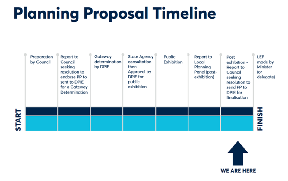
SUMMARY
1. Arising from the 2016 amalgamations, the current City of Parramatta Local Government Area (LGA) was formed from parts of the previous councils of the City of Parramatta, Holroyd, The Hills, Hornsby and Auburn. The current LGA has an area of 84 square kilometres and an estimated population of 260,296 (Source: City of Parramatta Community Profile, 2020).
2. A map showing the current City of Parramatta boundary (and former LGAs) is shown at Figure 1 and a map showing the current planning instrument boundaries is shown at Figure 2.
Figure 1 - Map showing the City of Parramatta boundary.
Figure 2 - Map showing the current land use planning framework for the City of Parramatta (including 5 x LEPs, 9 x DCPs, SREP 24 and excluding Sydney Olympic Park land) .
3. This report details the outcomes from the public exhibition of the Parramatta Harmonisation Planning Proposal (Harmonisation PP) and seeks Council endorsement of a revised planning proposal amending the Parramatta Local Environmental Plan 2011 (PLEP 2011), Hornsby Local Environmental Plan 2013 (HYLEP 2013), Holroyd Local Environmental Plan (HLEP 2013), The Hills Local Environmental Plan 2013 (THLEP 2013) and Auburn Local Environmental Plan (ALEP 2011) as they apply to the current Parramatta LGA boundary. The endorsement is to permit the plan to be forwarded to the Department of Planning, Industry and Environment (DPIE) for finalisation.
4. Having considered the submissions received, it is proposed to progress the exhibited Harmonisation PP and draft PLEP with only minor amendments.
5. In finalising the Harmonisation PP, Council’s policy direction for the “new” City of Parramatta LGA will be clearer, and together with the upcoming Harmonisation DCP, will seek to deliver on Council’s Local Strategic Planning Statement (LSPS) intention to: “improve the development application assessment process and provide a level of consistency in the planning framework” in the LGA for stakeholders (p.24 LSPS). A single LEP will enable a platform for future planning change consistent with long term strategic directions. The future City of Parramatta DCP will harmonise the nine DCPs that currently apply in the LGA, will complement the provisions in the new, harmonised LEP for the City of Parramatta and will create a clear set of development controls.
6. The information in this report is consistent with, and draws upon, the report to the Local Planning Panel meeting of 29 June 2021. The LPP report and attachments are each appended individually to this report.
7. The Panel supported the planning proposal being forwarded to the Department in the form recommended by Council Officers but also recommended Council undertake further future investigations on:
· the permissibility of dual occupancy on some sites in Winston Hills; and
· Council’s policy of the permissibility of Places of Public Worship in the R2 Low Density Residential zone.
8. The intention of the Harmonisation PP Process is to consolidate the various planning instruments that apply into one LEP for the City of Parramatta LGA. If Council determines to resolve differently to any of the officer recommendations listed in this report that may, depending on the nature of the alternate determination, trigger a re-exhibition of the Harmonisation PP and draft LEP.
BACKGROUND
9. Table 1 below outlines a chronology of key actions that Council has taken to progress the Harmonisation PP and draft PLEP.
Table 1 – Key actions related to the Harmonisation PP and draft PLEP
|
DATE |
EVENT |
|
12 May 2016 |
Local Government (City of Parramatta and Cumberland) Proclamation was notified. This resulted in the creation of the new City of Parramatta Council LGA, from parts of the former Auburn, Holroyd, Hornsby, Parramatta and The Hills councils. This triggered the need for a consolidated LEP for the new LGA. |
|
November 2017 to May 2018 |
Preparation of Land Use Planning Harmonisation Discussion Paper. A total of 7 Councillor Workshops were held. |
|
21 November 2018 |
Councillor Workshop on Discussion Paper. |
|
26 November 2018 |
Council endorsed the Discussion Paper. |
|
21 January – 4 March 2019 |
Exhibition of Land Use Planning Harmonisation Discussion Paper (Discussion Paper). A total of 539 submissions were received (222 written and 317 survey responses). |
|
April 2019 |
Council officers reviewed feedback on Land Use Planning Harmonisation Discussion paper. |
|
15 July 2019 |
Councillor Briefing/Workshop on Discussion Paper exhibition. Councillors raised concerns with the impacts of dual occupancies on local areas, particularly in relation to parking and traffic issues associated with dual occupancy development on narrow roads. Concerns were also raised of impacts on local character. The feedback received from Councillors has informed the preparation of the planning proposal. |
|
8 October 2019 |
Local Planning Panel (LPP) considered a report on the PP. LPP endorsed the officer recommendation, with 2 additional recommendations. The Panel’s subsequent advice to Council was consistent with the Council officer’s recommendation, i.e.that the dual occupancy prohibition areas not be further extended. The Panel also asked that there be greater targeted public consultation regarding dual occupancy (including the constraints analysis). |
|
6 November 2019 |
Councillor Workshop Pre-Briefing |
|
11 November 2019
|
Council considered a report on the Harmonisation Planning Proposal. It resolved to endorse a Planning Proposal to send to DPIE for a Gateway Determination. |
|
13 December 2019 |
Amended Harmonisation Planning Proposal (PP) – Consolidated City of Parramatta Local Environmental Plan (LEP) sent to DPIE for a Gateway Determination. |
|
16 April 2020 |
DPIE issued a Gateway Determination to proceed to public exhibition (with some amendments). |
|
31 August 2020 to 12 October 2020 |
Exhibition of Planning Proposal. A total of 320 submissions were received. A copy of the exhibited Planning Proposal documents are included as Attachments 7 to 13 of this report. |
|
17 August and 20 October 2020 |
Gateway Determination extended by DPIE until 30 June 2021. |
|
17 May 2021 |
Councillor Workshop - Post Exhibition update. |
|
28 May 2021 |
Council requested a Gateway extension from DPIE until 31 July 2021. A response from DPIE is pending. NOTE: The timeframe for submitting the PP to the LPP for finalisation by 30 June 2021 is consistent with ‘Alteration to the Gateway Determination’ issued on 30 June 2021. However, the report to Council for a decision to be made will not occur until 12 July 2021. Hence, an extension to the Gateway Determination date was sought. |
|
Local Planning Panel (LPP) meeting to consider a report on the Harmonisation PP and draft Parramatta Local Environmental Plan (LEP). The LPP endorsed the officer recommendation made in to Council in this report, with two additional recommendations. |
COMMUNITY ENGAGEMENT
10. A communication strategy was developed which outlined how Council would consult with the community during the Harmonisation Project and the Planning Proposal and draft PLEP exhibition period to ensure a fit for purpose, adequately resourced strategy and to ensure compliance with Council’s Community Engagement Strategy as well as the requirements of the Environmental Planning and Assessment Act 1979 for planning proposals.
11. The communication strategy for the Harmonisation PP and draft PLEP involved the following communication mechanisms:
· The Harmonisation PP and draft PLEP were exhibited for six (6) weeks commencing on Monday, 31 August 2020 and concluding on Monday, 12 October 2020
· Notification Letters – posted
· Notification Email
· City of Parramatta Website
· Participate Parramatta engagement portal
· Newspaper advertisement
· Media Release
· Social media including Facebook
· Booked phone calls referred to as ‘Phone a Planner’ sessions
· Hard copies of the exhibition package at the Council Contact Centre and Libraries
· Electronic Direct Mail (EDM’s sent)
· Online submission portal and formal submission process.
COMMUNITY FEEDBACK
12. The community feedback is detailed in the Community Engagement Report in Attachments 2 to 5.
13. A total of 320 submissions were received from the community in response to the public exhibition of the Harmonisation PP. Submissions are categorised as follows:
· Land Owners, Residents and Individuals (285 submissions);
· Public Authorities, Service Providers and Elected Officials (21 submissions); and
· Institutions, Organisations and Consultants (14 submissions).
14. The summary of submissions appended to the Community Engagement Report provides provide a summary of each submission and a response to the issues raised within the submission.
PLANNING DECISION PATHWAYS
15. Some of the submissions sought changes to the exhibited planning controls. Council officers seek to minimise the number of changes made to the exhibited plan to those of minor significance. The risk of adopting significant changes without re-exhibition is that the Plan can be declared legally invalid as occurred in the case of Friends of Turramurra Inc vs Minister for Planning before the Land and Environment Court ([2011] NSW LEC 128]) where a draft LEP was declared invalid by the Court because of substantive changes made to the instrument post-exhibition without a re-exhibition process.
16. Hence, Council officers recommend proceeding with the Draft Harmonisation PP without re-exhibition as only very minor changes are proposed. There are a number of more significant changes that could be considered by Council, but to avoid re-exhibition it is recommended that a separate housekeeping planning proposal be undertaken or a similar alternate planning process be pursued. The decision pathway approach recommended in this report reflects a cautious approach to the inherent risk to an instrument’s validity.
17. Attachment 1 to this report provides a schedule of recommended changes that fall under Decision Pathways 1, 2 or 3, that is,
· Decision Pathway 1 – Minor Amendment Proceed ( Green) – detailed in Attachment 1 Table 1
· Decision Pathway 2 – Proposed amendment does not have merit. Do not proceed (Red) – detailed in Attachment 1 Table 2
· Decision Pathway 3 - Issue to be addressed through other planning process- detailed in Attachment 1 – Table 3.
18. Regarding the issues that ‘have merit for further investigation’ listed in Attachment 1 Table 3, an assessment of each of the issues raised will be undertaken once the Harmonisation Planning Proposal is finalised. This will allow the issues to be prioritised and a draft work program to be prepared and reported to Council later in 2021.
19. If Council wishes to proceed with these amendments immediately, a resolution would need to be pursued to re-exhibit the Harmonisation Planning Proposal with these amendments included. This would delay the consolidation benefits of moving to a single LEP.
Feedback from Landowners, Residents and Individuals
20. Whilst each potential amendment requested in the submissions is addressed in Attachments 3 to 5 this section of the report will deal with 15 issues which were either raised in numerous submissions or which have more significant policy implications.
Key Issue 1 - Dual Occupancy
21. The LSPS endorsed in 2020, contains Action A30 (under LSPS Planning Priority 5 p.58) to “finalise the review of dual occupancy and medium density residential zone provisions for Government’s consideration as part of the LEP Harmonisation Project.” The zone provisions have been reviewed as part of the Harmonisation PP and draft PLEP consistent with Council’s LSPS action. Separately, in 2020, Council prepared a Local Housing Strategy, and the recommendations in this report are consistent with that Strategy.
22. The majority of resident submissions received (219 or 77%) received raised dual occupancy as a key issue with submissions either supporting or objecting to the permissibility of dual occupancy in their area. An overview of the key issues raised in relation to dual occupancy is presented below.
23. The recommendations in this report relating to
dual occupancy overall seek to proceed with the recommendations
as exhibited with no change to the draft PLEP. The only changes proposed
under (Key Issue 1d) relate to minor mapping and administration matters.
Key Issue 1a - Dual Occupancy – Relaxation of Dual Occupancy Prohibition Areas and Controls
24. A total of 186 submissions lodged sought amendments to the plan to allow dual occupancy development in locations where the Harmonisation PP is seeking to prohibit dual occupancy, or to ask Council to relax its requirement in areas where dual occupancy will be permitted to allow dual occupancy on sites less than 600sqm. The number of submissions that supported the proposed restrictions on dual occupancy development or sought changes to further limit where dual occupancy was permitted was 31 of total submissions.
25. There was support for relaxing the permissibility in most of the suburbs where it is proposed to prohibit dual occupancy with particular concentrations in Eastwood, Dundas Valley and Carlingford. Attachment 6 shows the distribution of submissions across the LGA that support or oppose dual occupancy prohibition.
26. Figure 3 below was provided with the exhibited PP and shows the 5 existing LEP controls as they currently apply as well as the proposed controls in the Harmonisation PP. The black line shows the former LGA boundaries.
Figure 3 - Dual Occupancy - Proposed Permissibility and Prohibition areas
27. The submissions opposing the proposed prohibition of dual occupancies in certain areas raised the following concerns:
· Prohibition areas are unfair, discriminatory and inconsistently applied.
· Dual occupancies contribute to housing affordability, choice and diversity.
· Prohibition will reduce property value / will have financial implications for land owners.
· The proposal is inconsistent with Ministerial Direction 3.1 as it includes a number of amendments which will reduce the supply and diversity of housing in the LGA.
· Some location are unconstrained according to the Dual Occupancy Constraints Analysis.
· Dual occupancies are already part of many low-density streetscapes and in some cases R2 zoned land includes higher density development.
· Dual occupancies can contribute positively to the streetscape and present like a single dwelling.
· This type of development supports and maintains family networks.
· Concerns about negative impact of dual occupancies are unsubstantiated.
· Dual occupancies should be managed through design controls and not outright prohibition, including a larger minimum lot size and frontage requirement.
· Dual occupancy developments offers a better living environment than high rise development.
· Some locations are within close proximity to major roads, services and infrastructure.
· Traffic and amenity impacts are negligible compared to other types of development.
· Granny flats are allowed and have the same/worse impact.
· Well-designed dual occupancies can be accommodated on lots under 600sqm / the NSW Government permits dual occupancy on lots under 600sqm.
28. The submissions supporting the proposed prohibition of dual occupancies in certain areas gave the following reasons:
· Dual occupancies are incompatible with the character of low density areas and are more conducive to R3 or R4 zoning.
· Dual occupancy development results in more on street parking and creates traffic and congestion issues.
· Concerns about safety.
· General concerns with overdevelopment and proliferation of dual occupancy development.
· Concerns over disruption and noise from construction.
· Concerns about loss of tree and impacts on wildlife.
· Concerns about impacts on privacy, solar access, amenity and general quality of life.
Response
29. Council prepared as part of the Harmonisation PP process (following the Discussion Paper) a dual occupancy constraints analysis which mapped and considered: areas with special character; narrow streets; areas lacking permeability; access to public transport; tree coverage; bushfire hazard; and site availability. This constraints analysis:
“…identified much of the low density residential land in Beecroft, Carlingford, Epping, North Rocks, Northmead, Oatlands and Winston Hills as having a high level of constraints to dual occupancy development. Parts of Dundas and Dundas Valley were also identified as having constrained land…” (refer to Council’s Local Housing Strategy, Section 2.7, p.72 at).
30. Regarding future housing supply, Section 2.2.2 in the LHS details how background housing growth (outside growth precincts) was calculated:
“…For all land in an R2 Low Density zone, where the lot size is above 600sqm, it is assumed there is potential for an additional dwelling in the form of a dual occupancy, except where dual occupancies are prohibited. Prohibition areas proposed as part of the Harmonisation Planning Proposal were utilised to calculate capacity for this form of housing delivery, informed by data on approvals between July 2016 – November 2019. … It is noted that in areas where dual occupancies are prohibited, secondary dwellings remain permissible on sites as small as 450sqm under the provisions of the SEPP Affordable Rental Housing 2009.
For R3 Medium Density land, dwelling capacity was undertaken …to account for the coming introduction of the Low Rise Medium Density Housing Code….”
31. Furthermore, Section 2.5 in the LHS has found that there is more than 50 years of land supply for dual occupancy development.
32. Dual occupancy development, in the right locations, can provide further housing opportunities for families. Taking into account the proposals of the Harmonisation PP, there will remain a theoretical capacity for approximately 8,245 additional dwellings through dual occupancy development on R2 Low Density Residential zoned land, though it is noted that historically R3 zoned land has also been a supply of dual occupancy development (c. 8 dwellings per year). At current rates of take-up (c. 160 dwellings per year in total, and 154 dwellings per year on R2 zoned land), there would remain more than 50 years of land supply (LHS, Section 2.5, p.64).
33. Considering the very high level of housing delivery in the LGA (for example above the DPIE targets for the Parramatta LGA), the LHS states that instead of expanding dual occupancy use within the LGA, further housing diversity with innovative options for households with children, should be explored in the future Growth Precincts (which includes area such as the CBD, North Parramatta, Telopea and Melrose Park) for hybrid townhouse/residential flat building forms. This could also serve to offer better transitions to neighboring lower density zones (LHS, Section 2.5, p.64).
34. The strategic position proposed regarding dual occupancies within the Harmonisation Planning Proposal and Draft LEP is consistent with Council’s endorsed LHS. None of the issues raised in submissions suggesting the prohibitions on dual occupancy should be relaxed provide sufficient justification for Council to move away from its current position.
Key Issue 1b - Dual Occupancy Prohibition in part of Winston Hills
36. Within the area outlined in yellow the sites coloured green are those where dual occupancy would be permitted. The sites shown in salmon colour are sites where dual occupancy would not be permitted because the site does not meet the minimum lots size requirement of 600sqm.
Figure 4 - East Winston Hills Dual Occupancy Prohibition and Permissibility Areas
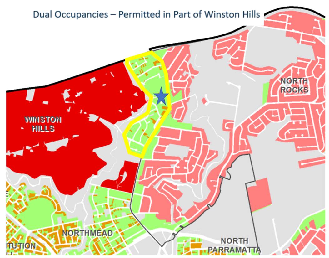
37. As can be seen in Attachment 6 the submissions seeking to have dual occupancy prohibited are all concentrated in an area in the middle of this precinct where the blue star is located in Figure 4 above and in more detail in Figure 5 below. The reasons for requesting the prohibition be extended to this area is due to concerns about amenity impacts on adjoining residents including traffic and parking issues.
Figure 5 - East Winston Hills Dual Occupancy Prohibition and Permissibility Areas
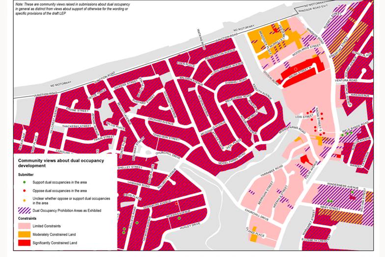
Response
38. The results of the constraints mapping did not result in a decision to prohibit dual occupancy development in the area shown in the extract. The constraints mapping looked at a range of issues including built form character, potential for on-street parking problems, tree cover, lot size and access to public transport in determining whether an area was constrained or not. The areas where the submissions are concentrated were not identified as a constrained area. Whilst it is acknowledged that introducing dual occupancy in an area does have impacts, the precinct where the submissions were lodged was not assessed as highly constrained and therefore is capable of accommodating dual occupancy without unacceptable impacts. It is noted that some dual occupancy has already occurred in the area (as it is currently permitted under the existing LEP provisions). Therefore no change is proposed to the exhibited controls.
Key Issue 1c - Dual Occupancy Prohibition in Heritage Conservation Areas (HCAs)
39. The exhibited Harmonisation Planning Proposal seeks to prohibit dual occupancy development in all Heritage Conservation Areas, (HCAs) with the exception of the South Parramatta HCA which has had precinct specific controls recently developed and implemented to make sure dual occupancy is introduced in a sensitive manner. This affects approximately 150 properties.
40. Eight submissions were received objecting to this policy. The arguments put forward for why Council should allow dual occupancy in Heritage Conservation Areas are the same as those listed under the heading 1a to justify dual occupancy prohibitions across the entire LGA being relaxed.
41. Dual occupancy prohibition is being pursued to assist with retention of the special character of these HCAs.
Response
42. The LEP Harmonisation PP primarily proposes to continue prohibiting dual occupancy development where it is currently prohibited under existing LEP controls. However, as part of the Harmonisation Planning Proposal a dual occupancy constraints analysis was undertaken which considered: areas with special character; Narrow Streets; areas lacking permeability; access to public transport; tree coverage; bushfire hazard; and site availability.
43. Section 2.1 of the dual occupancy constraints analysis identified that existing Heritage Conservation Areas (with the exception of South Parramatta Conservation Area, where special local provisions have recently been applied through a site-specific rezoning process) have special character that is to be protected.
44. The heritage value of a conservation area lies not just with the heritage significance of individual buildings, but with other factors, including landform, subdivision and the history of development. For many areas the changes to the streetscape and subdivision as a result of dual occupancy development would not be compatible with the heritage significance of these areas. Beecroft and Epping were also identified as potential special character areas.
45. Proposed changes to the exhibited PP on this matter is not supported based on this strategic planning merit assessment and the long-term land use planning objectives of Council.
Key Issue 1d - Dual Occupancy Prohibition based on a Minimum Lot Size of 600sqm
46. The exhibited PP mapped all existing properties less than 600sqm to apply a prohibition on dual occupancy on these sites. Concern in submissions was raised about the accuracy of the mapping and survey data of existing properties. Also concern was raised about mapping lots spatially as ‘prohibiting dual occupancy’ when properties might be subdivided and/or consolidated in the future to result in a different lot size.
47. Two development industry submissions raised concern that the prohibition of individual lots would preclude the opportunity to consolidate and re-subdivide lots to comply with the Minimum Lot Size control.
48. Various landowners have advised their land which is mapped as less 600sqm is actually larger than 600sqm – therefore incorrectly prohibited from dual occupancy development.
49. Concern is raised that the mapping process for identifying lots as less than 600sqm on the prohibition map may be reliant on inaccurate data and be prohibiting dual occupancy development on lots that would comply with the 600sqm control. One submission suggests Council rely on a clause limiting dual occupancy on 600sqm sites rather than seeking to prohibit them by showing sites on a map.
Response
50. If the circumstances above apply and the sites are incorrectly mapped, land owners would be required to submit a planning proposal to amend the LEP mapping and Council would have no policy justification to refuse the application. However, requiring this process would be inefficient for both the applicant and Council in these circumstances.
51. It is therefore recommended that the intended prohibition of dual occupancy on lots less than 600sqm remains as per the public exhibition however the mapping of sites with an area of less than 600sqm will be deleted. Clause 4.1D as exhibited is a written clause that achieves the same function, and which also allows for change in lot sizes and other circumstances over time. This minor change will not require re-exhibition of the Planning Proposal.
52. Ideally, the standard LEP Clause 4.6 – Variation to Development Standards would be modified to strengthen the dual occupancy restriction however written advice from DPIE has indicated (during the Gateway extension) that modifying Clause 4.6 would not be supported by DPIE.
Key Issue 2 - Rezoning in Northmead and Carlingford from R3 (Medium Density Residential) to R2 (Low Density Residential).
53. Figure 6 below shows the location of two precincts where the Draft Harmonisation PP seeks to downzone the sites from Residential R3 to Residential R2.
Figure 6 - R2 Low Density Residential (and Dual Occupancy Prohibition) area - Northmead and Carlingford
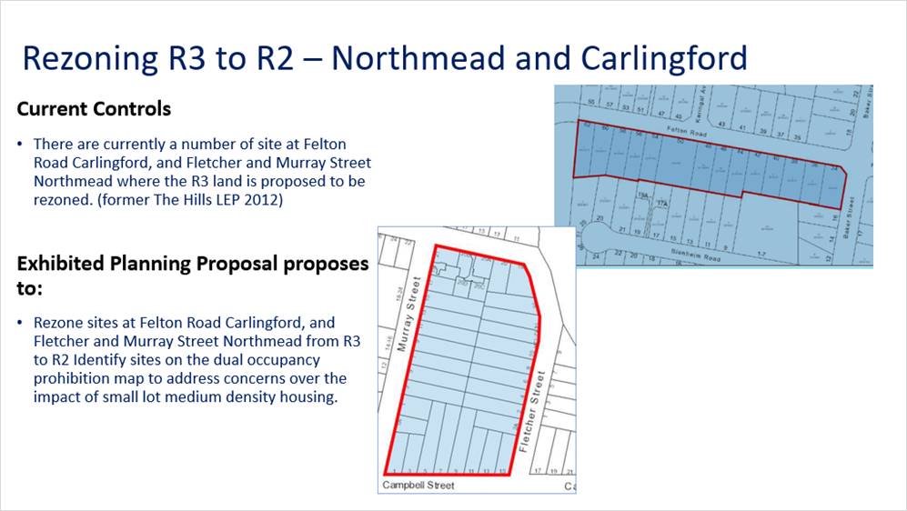
54. At Felton Road the intent is to make the density consistent with the density on the northern side of Felton Road and to retain the character on both sides of Felton Road given that only one site on the southern side has been developed.
55. At Murray Street the concern is that the deep blocks do not produce ideal urban design outcomes. The precinct already contains other R3 Medium Density and R4 High Density sites that have been developed. The broader precinct also has limited road network permeability with all access via Windsor Road which contributes to traffic congestion issues.
56. The submissions of objections overall (8 of the 19 submissions received) cite concerns about loss of value of their property, issues about land value and reduction in development potential are acknowledged but if Council’s objective of maintaining consistency in controls on both sides of Felton Road are to be achieved the objections cannot be supported.
57. At Felton Road Carlingford, most affected landowners oppose the rezoning and inclusion on the dual occupancy prohibition map.
58. At Fletcher and Murray Street, Northmead, two owners object to the rezoning and one landowner supports the rezoning.
59. Key concerns raised in these submissions are:
• Devaluing owners land
• Unfairness due to owners paying ‘R3 level Council rates’
• Arguments that other areas have medium density on one side of the road and single dwelling zone on the other
• Restriction of development options given the need to provide for increasing housing close to public transport
• One site in area to be rezoned has already been developed for townhouse and so this should be seen as a precedent for the others to be permitted the same development.
Response
60. Whist the impact on the redevelopment potential and possible land value is noted the submissions do not raise any issues that warrant Council amending its planning policy position for these areas.
Key Issue 3A – Heritage Listing on Large Sites
61. Three submissions: The Kings School; AMP Capital (for Truganini House) and Schools Infrastructure have requested Council reconsider the way heritage items are shown in the LEP. In these cases, there are heritage items located on large sites and the entire site is shown as the listed heritage site.
62. This has impacts for how development occurs on parts of the site away from the heritage item as exempt and complying development cannot be pursued on any listed site. This means any development/changes on those parts of the site must pursue the more time consuming and costly development approval path.
Response
63. It is normal practice for the lot containing a heritage item to be identified in the LEP Heritage Schedule by the lot and DP containing the site and for the entire lot to then be shown on the Heritage Map as the location of a heritage item.
64. It is acknowledged that where a heritage item is located on a very large lot that this designates the entire lot as a heritage site for the purpose of development assessment, and that this can in some cases lead to heritage assessments being required for minor development that have minimal impact on the heritage item that may be also located on another part of the site.
65. Another issue is that exempt and complying development that cannot be carried out on heritage sites must be approved via a development application process even if they are located well away from the heritage item.
66. Given this there have been precedents for only parts of lots to be shown as the listed heritage item.
67. However, pursuing this pathway does require some analysis. Showing just the building itself as the heritage listed portion of the site may not be appropriate in many cases because development adjoining the item and views to and from the item must also be taken into account.
68. If part of the site is to be shown as the heritage listed area Council must be confident that the area selected is an accurate presentation of the heritage item and its curtilage which often is also significant in ensuring the item can be interpreted in its proper context.
69. Council Officers are supportive of the proposal to review the area of land shown as the listed area in principle but recommend that the process of determining the proper heritage curtilage and amending the LEP be undertaken as a separate process.
70. The intention of the Harmonisation Process is to consolidate the various instruments that apply. Making changes to listed items is not consistent with the scope of this project. Including the proposal at this point in time would also require re-exhibition of the plan which would delay finalisation of the Harmonisation Planning Proposal.
Key Issue 3b - Biodiversity Mapping of Key Sites
72. Two submissions relating to large sites: The Kings School and EG North Rocks Road, North Rocks (former site of Royal Institution for Deaf and Blind Children) have raised a similar issue in relation to the impact that the biodiversity designated land has on their ability to develop their sites. Areas shown to be within the biodiversity areas on the relevant LEP Map can in theory still be developed, but they need to go through the development approval process to ensure a proper assessment of the biodiversity issues is addressed. More streamlined approval processes for development such as exempt or complying development cannot be pursued.
73. The submission authors question whether the areas mapped on their sites are of sufficient biodiversity value to warrant their inclusion on the map.
Response
74. Council Officers are supportive of a review of the exhibited Biodiversity Map but to avoid delay to the Harmonisation Planning Proposal are recommending this be considered as a separate planning process.
75. In some cases (Kings Schools submission for example) a biodiversity assessment has been provided. In cases where the assessment has not been completed it would be the responsibility of the owner to justify what the mapped area should be. Landowners can either pursue a site specific Planning Proposal supported by a biodiversity assessment or submit it to Council for potential inclusion in a future LEP Housekeeping Amendment process.
76. Immediate changes to the Plan as part of the Harmonisation Planning Proposal would require re-exhibition of the Harmonisation Plan which is not recommended.
Key Issue 4 Rezoning of Transport for NSW (TfNSW) owned Environmental Protection Sites
77. The exhibited Harmonisation Planning Proposal proposes:
• At 30X Epping Road Epping - rezone land from SP2 to E2
• A bushland site off Murray Farm Road abutting M2 Motorway - rezone land from E4 to E2.
78. TfNSW opposes these rezonings and this could be considered an unresolved agency objection which may need to be ultimately determined by DPIE. TfNSW claims Council has not satisfactorily demonstrated the sites warrant the land being rezoned to E2. And is also concerned that rezoning the land would limit the development potential of the land to which it adjoins.
Response
79. The sites are both bushland sites containing Coastal Enriched Sandstone Moist Forest vegetation communities.
80. Council is not proposing to retain the E4 Environmental Living zone that exists in the Hills LEP and applies to the Murray Farm Road site so the site must transition to another zone and the E2 zoning is the most appropriate alternative given the site is covered in dense vegetation, and the fact that TfNSW has not identified an alternate use or potential zoning.
81. The Epping Road site is zoned as SP2 Road Reservation and sits between two road corridors (Pembroke St and Epping Road). Given the TfNSW objection it can only be assumed there remains some potential future need for road widening or works associated with the road network located on either side of this site. It has little practical potential for other uses. If TfNSW does propose any works related to the road network on this site (for example, improved drainage arrangements or further road widening) in this bushland area they will still be required to assess the environmental impacts, and so if this is the case the SP2 zoning that currently applies is the appropriate zoning. It is recommended that the Planning Proposal be amended and the SP2 zoning be retained for this site. Retaining a site at its current zoning is not an amendment to the exhibited Planning Proposal that would warrant re-exhibition.
Key Issue 5 - Places of Public Worship
82. The Planning Proposal proposes to prohibit Places of Public Worship (POPW) in the R2 Low Density Residential zone. Further, it proposes that existing POPWs that are located in the former City of Parramatta LEP area and which are currently zoned SP1 Special Activities be rezoned R2.
83. This change means that POPW that operate in low density zones will continue to operate under existing use rights provisions which allow for some change to or expansion of the use subject to a merit assessment.
84. Six (6) submissions were received (5 land owners, 1 from an industry body) which raise the following issues:-
· Oppose the rezoning of PoPW from SP1 to R2
· Oppose the prohibition of PoPW in R2 zone
· Support the rezoning of SP1 to R2 but only subject to PoPW being permitted with consent in R2 zone
· Claims unfair and impacts on the ongoing viability and growth options for existing PoPW to rely upon Existing Use Rights. Request for existing sites to be identified in the Additional Permitted Use (APU) Schedule in LEP (as per old DPIE circular).
Response
85. The Council policy position on this issue is driven by concerns about the amenity impacts of Places of Public Worship in Low Density Residential Zones.
86. The prohibition on POPW in the R2 zone seeks to ensure that these uses are encouraged to find more appropriate locations and that existing operating POPWs can only expand their operations on the sites they currently occupy under existing use rights provisions.
87. The proposal to rezone existing sites from SP1 to R2 seeks to make it easier for these sites to transition to a more appropriate use should they cease to operate in the future. If the current SP1 zone is retained these sites would need to be rezoned if there is an opportunity to transition to some more appropriate residential use in the future. The controls proposed seek to make it as easy as possible for these sites to transition to sites more appropriate to their operation away from low density residential neighbourhoods.
88. The submissions objecting generally raise concerns about the impact this may have on their operations and opportunities to expand but none have been able to address Council’s underlying concern over their impact on the amenity in low density precincts. In this context no amendments to the exhibited controls are recommended.
Key Issue 6 – Permissibility of Advertising Structures
89. The exhibited Planning Proposal proposes to prohibit general advertising structures in all zones in the LGA, consistent with the current approaches under both Parramatta LEP 2011 and Parramatta (former The Hills) LEP 2012.
.
90. A submission was received from the Outdoor Media Association discussing:
• Impact of changes on advertising industry
• Applications/licences for existing signage will not be renewed
• Prohibition will impact upon local areas as advertising structures promote local of goods and services
• The association provided their own analysis to seek to justify their position that the LGA should be opened up to permit more advertising.
Response
91. General advertising which does not relate to the specific use of a site is not considered appropriate due to visual impact and concerns about visual clutter. While the applicant has argued that the role of advertising is important and modern advertising adds value to the community Council should not pursue any change to their policy position without undertaking its own independent analysis.
92. The provisions of SEPP 64 will continue to apply to building and business identification signage, which will continue to be permitted, and the display of advertisements on transport corridor land is also covered by this policy.
93. The draft Parramatta LEP proposes to identify advertising on bus shelters owned or managed by Council as exempt development under Schedule 2.
94. Existing approved advertising structures can be considered under the EPA Act and EP&A Regulation which contain provisions to assess development applications for lawfully approved existing uses.
95. The objective of the Harmonisation Planning Proposal process is to consolidate five separate policy positions, rather than enter into a debate about what may be considered to be a significant change to the policy position. In this context no change to the exhibited Planning Proposal is recommended.
Key Issue 7 - Development Near Zone Boundaries Clause
96. Each current LEP that applies in the City of Parramatta LGA contains a Clause 5.3 relating to development near zone boundaries. In each of the clauses the former Council has nominated a distance within which uses permitted in a zone can extend into the adjoining zone.
97. Currently the Auburn, The Hills and Hornsby LEPs apply 20m, Holroyd 10m and the City of Parramatta 1m as the distance that uses can extend into an adjoining zone. The exhibited Planning Proposal proposes to adopt 1m for the whole LGA.
98. A Sydney Trains submission opposes the proposed 1m nominated distance. It claims 1m is too restrictive and prevents application of clause for intended purpose. It recommends 20m instead, consistent with Auburn, The Hills and Hornsby LEPs.
Response
99. The justification put forward in submissions for inserting a greater distance is that it promotes more flexibility in the planning controls along zone boundaries. However, allowing 10m or 20m could inadvertently permit other uses that are inconsistent with strategic intent. The clause is rarely used and allowing it to be used more extensively increases the opportunity for it to be used for purposes inconsistent with Council’s strategic objectives.
100. Council Officers consider that the submission from Sydney Trains alone is not justification for Council to move away from the exhibited position but this might be considered as an unresolved agency submission and DPIE may seek to amend the proposal post Council endorsement if it considers the Sydney Trains submission has merit.
Key Issue 8 - Newington
101. A total of 3 submissions objected to proposed changes to raise the permitted Height of Buildings (HOB) from 9 to 11 metres, apply a standardised FSR and introduce a Minimum Lot Size (MLS) of 550sqm into the suburb of Newington.
102. The submitters raises concern that proposed LEP changes are inconsistent with the Newington Community Title Community Management Statement and the related formal Architectural and Landscaping Standards that underpin the design concept for the suburb.
Response
103. Currently there is no LEP minimum lot size control applying to as the lot size controls are within the former Auburn Council DCP.
104. The Harmonisation Planning Proposal changes seek to standardise planning controls and provide consistency across a consolidated Parrramatta LGA. In doing so standard building heights and minimum lot sizes have been proposed to be introduced.
105. Newington has a somewhat unique situation being a large community title subdivision where the development potential has already been realised and the building heights and lot sizes are specific to that community title development. The submissions articulate a concern that by introducing a change in the planning controls there would be a perception that further development is possible contrary to the existing community title provisions.
106. The harmonisation of planning controls seeks to provide consistency where possible with existing provisions and introduce planning controls to reflect already endorsed strategic directions. Introducing new planning provisions to Newington could have unintended consequences and create unrealistic expectations for development potential in a ‘completed’ community title estate.
107. The submission is supported and it is recommended that minor changes be made to the Harmonisation PP and draft PLEP to retain the previous controls (under the Auburn LEP) for Newington i.e. a 9 metre height limit, no MLS be introduced to Newington and the existing FSR of 0.75:1 be retained. This will not require re-exhibition of the plan.
108. It is intended that the proposed harmonisation of the various DCPs into one Parramatta DCP will similarly retain the existing DCP controls applying to Newington’s community title development rather than standardised with LGA wide controls intended for ‘traditional’ Torrens title housing lots and building heights.
Key Issue 9 - Numbering of State Listed Heritage Items
109. The exhibited planning proposal seeks harmonise all listings from all former Councils areas into a single Schedule 5 for the new draft Parramatta LEP including all heritage items.
110. Items with State level significance were proposed to be identified using State Heritage Register inventory numbers to avoid having two sets of numbers for the same set of items.
111. However, Heritage NSW do not support item numbers listed in the schedule being the same for both local and state listings. They would prefer that in LEPs State items have their own separate identifier in the LEP and that the State Heritage Register Inventory number not be used in LEPs.
Response
112. In response to this submission the State listed heritage items will be renumbered so they are no longer identified by their State inventory number. This is a minor administrative amendment with no policy implications and does not require re-exhibition of the plan.
Key Issue 10 – North Rocks Industrial Precinct
113. The exhibited Planning Proposal proposes to prohibit “child care centres” and “tourist and visitor accommodation” in all IN1 zones including the North Rocks Industrial Precinct.
114. Land owners within the North Rocks Industrial Precinct oppose prohibition of these land uses and argue that that a key concern is that the precinct is under performing, demonstrated by increasing vacancies.
115. A submission requests greater diversity in land uses typologies in the precinct or consideration of rezoning to allow mixed use development.
Response
116. The proposal to standardise land uses permitted in all the IN1 Industrial zones across the LGA needs to take into consideration the appropriateness of the uses in an industrial context. The operation of child care centres and tourist and visitor accommodation in industrial zones is not supported. It is not recommended that child care centres be permitted in industrial zones where children are more likely to be exposed to undesirable risks. The promotion of tourist and visitor accommodation in industrial zones is not consistent considered desirable as generally these uses should be promoted in areas with better transport options and supporting services and facilities.
117. If an industrial precinct the scale of the North Rocks precinct is struggling there are limited options available to address this under the Standard Instrument LEP, which discourages precinct specific controls in order to increase standardisation of controls across the entire planning system. Should the owners/operators have suggestions on how planning controls might be reconsidered to help improve the vibrancy and use of the centre, Council Officers are willing to consider these options but they should be focused on promoting employment uses, rather than additional uses which are not compatible.
118. Any other opportunities will need to be dealt with via a separate Planning Proposal process as the Harmonisation Planning Proposal process objective is to consolidate the different plans and not introduce new policy settings.
119. The proposed changes suggested in submissions for the exhibited Harmonisation PP are not supported as the proposal is outside the scope of this planning process.
Key Issue 11 - Minimum Lot Size in R2 Low Density Residential Zones
120. Submissions were received in relation to (generally) the minimum lot size for standard residential lots in a subdivision. Most of the submissions raised concerns about the proposed change in the former Hornsby LGA where the control increases from 500sqm to 550sqm. The minimum lot size for the former The Hills area is retained at 700sqm and there is no change to the lots size in the former Parramatta areas as the 550sqm controls is retained. Battle-axe lots require a Minimum Lot Size (MLS) of 670sqm across the LGA. Submissions were lodged raising objections to the 700sqm control in the former The Hills and the 550sqm being applied to the remainder of the LGA. A single objection was received to the battle axe minimum lot size.
121. The majority of submissions were from landowners in Epping stating concerns that this would impact on their ability to subdivide their properties. The main issue was their loss of development opportunity with some submissions mentioning the need for increased housing supply.
Response
122. The approach when reviewing these controls was to make the minimum lot size more consistent. Changing the minimum lot size can have an impact on the density of development and the character of the area as smaller lots means dwellings located much closer together that larger lots.
123. The character of an area will not be impacted by a minimal increase in minimum site area from 500sqm to 550sqm. However a change from 500sqm to 700sqm would have a much more significant impact. Therefore to maximise consistency whilst still retaining the different character of the areas two minimum lot sizes of 550sqm and 700sqm are appropriate.
124. Completion of Council’s Local Housing Strategy has confirmed there is no need to lower the minimum lot size to assist with housing supply as Council can meet its targets without having to rely on this policy change.
125. Whilst it is acknowledged that some owners may be restricted from subdividing their sites, in Epping in particular no strategic justification has been demonstrated for Council changing its exhibited position on minimum lot size. In addition landowners can seek to vary the control if they can justify it on a site specific basis as part of any development application. As a result no change is proposed to the exhibited controls.
Key Issue 12 – Application of FSR in R4 High Density Zones
126. The exhibited Planning Proposal proposes to apply a FSR, matched to the existing height control, to R4 zoned sites where no FSR control is currently applied under the Hornsby LEP 2013 and Parramatta (former The Hills) LEP 2012. The FSR varies depending on the height and other controls that apply based on a detailed assessment by Council’s Urban Design Team. There are no proposed changes to the height of building controls in these areas.
127. The Harmonisation PP identified that applying an FSR to sites where there is currently not one will provide greater certainty to landowners and the community as to the density outcomes sought on the site.
128. Submissions were received from 11 owners in relation to changes to FSR in R4 zones. All submissions related to Epping and Carlingford sites. The majority of submissions requested that no FSR be applied or Council consider a higher FSR without specifying the FSR requested except in the three cases in Table 2:
Table 2 – Request for Alternate FSR for R4 zoned sites in Epping/Carlingford
|
Site/s |
Proposed in Exhibited PP |
Submission Request |
|
2 and 2a Hepburn Avenue and 199-203 Carlingford Road, Carlingford |
1.3:1 |
1.65:1 FSR approved under DA/863/2016 |
|
45-53 Oxford Street, Epping |
3.8:1 |
6.6:1 FSR approved under DA/646/2019 |
|
2-16 Epping Road and 2-4 Forest Grove, Epping |
Part 2:1 and 1.4:1 |
2.5:1 proposed under DA/397/2020. Lodged July 2020, refused and going to LEC. |
129. Arguments put forward in support of these requests included:
· Proposed FSR is inconsistent with development approved or currently under assessment
· Insufficient urban design information has been released to enable the public to understand the proposed density and development potential. It is unclear how the proposed FSR has been determined
· The proposed FSR will restrict development and is considered a substantive change beyond the objectives of a consolidation LEP planning proposal.
Response:
130. Council has reviewed the development applications lodged and also the planning appeals made. All matters considered were assessed without an FSR control in place. Sites were examined on a bespoke basis as there was no strategic planning control set. The Oxford Street site was a unique example due to mixed use components that do not apply to most other sites.
131. Council's Urban Design team advised that without an FSR control in the LEP the assessment of built form and scale must be done on a case-by-case basis which is extremely time consuming both for Council and the applicant. This also does not provide a community agreed, transparent and long-term future direction.
132. Adding a FSR control will provide greater certainty and transparency for council, community and applicants.
133. The Urban Design team confirmed that the proposed FSR provides adequate development capacity consistent with Council strategic housing supply objectives.
134. The purpose of the Harmonisation Planning Proposal is to consolidate former LEPs and provide consistent land use and development controls across the LGA. It is Council’s intent to apply a FSR to all residential zoned land across the LGA for consistency and provide greater certainty of development outcomes for the community. The application of a FSR control to R4 zoned land, such as in Epping, would provide greater clarity for the assessment of development applications, and FSR controls are proposed that are consistent with strategic plans for identified centres.
135. Proposed changes detailed in submissions to the exhibited PP for the FSR applied in R4 zones are not supported for the reasons detailed above.
Key Issue 13 - Application of FSR in R3 Medium Density Residential Zones
136. In summary, the Planning Proposal proposes to apply a FSR of 0.6:1 to R3 Medium Density Residential land in the former Hornsby and Parramatta LGAs, where no FSR applies. It also proposes to reduce the FSR for R3 land in Silverwater from 0.75:1 to 0.6:1 in the Auburn LGA. This change in Silverwater will affect approximately 212 properties.
137. Six objections were received in relation to changes to FSR in R3 zones. 3 from Silverwater landowners; 2 from Epping landowners and 1 from a Carlingford landowner.
138. In Epping and Carlingford the concern was that the density the developer/landowner could achieve would be lower than what would be achieved if no FSR was applied. However in Silverwater the following issues were raised:
· The proposed FSR changes go against the planning proposal’s overall objective and reduce the permissible development capacity for property owners
· Why have changes been proposed for Silverwater and not Newington
· The proposed changes in FSR do not meet the housing needs of the Silverwater community
· Overlooks the existing provisions of Clause 4.4 (2A) in the Auburn LEP, which enables higher FSR for multi-dwelling housing. Removing this provision will stifle the delivery of multi-dwelling townhouses that have become common in the area.
Response
139. The reasons it is important to apply a FSR are discussed in the response in the previous section that deals with the application of an FSR in the R4 zone.
140. The purpose of the LEP Harmonisation Planning Proposal is to consolidate former LEPs and provide consistent land use and development controls across the LGA. It is Council’s intent to apply a FSR of 0.6:1 to all R3 zoned land across the LGA for consistency and provide greater certainty of development outcomes for the community.
141. Council’s Urban Design team has reviewed the proposed controls for the R3 precinct in Silverwater where the FSR is proposed to be decreased and confirmed appropriate scale of built form can be achieved under the proposed 0.6:1 FSR and 11m height of building control. They consider that the higher densities previously proposed do not achieve optimal design outcomes.
142. The changes to the FSR controls requested in submissions are not supported for the reasons detailed above.
Key Issue 14 – Introducing an FSR into R2 Low Density Residential Zones
143. The Planning Proposal seeks to apply a FSR of 0.5:1 to R2 zoned land in former Hornsby and The Hills areas where no FSR currently applies, consistent with R2 zoned land in other parts of the LGA. A FSR of 0.5:1 is typical across most low density zones in Sydney. Such an approach will help maintain the low density character of these neighborhoods.
144. The area affected by this change can be seen at Figure 7.
Figure 7 - FSR in R2 Low Density Residential Zones
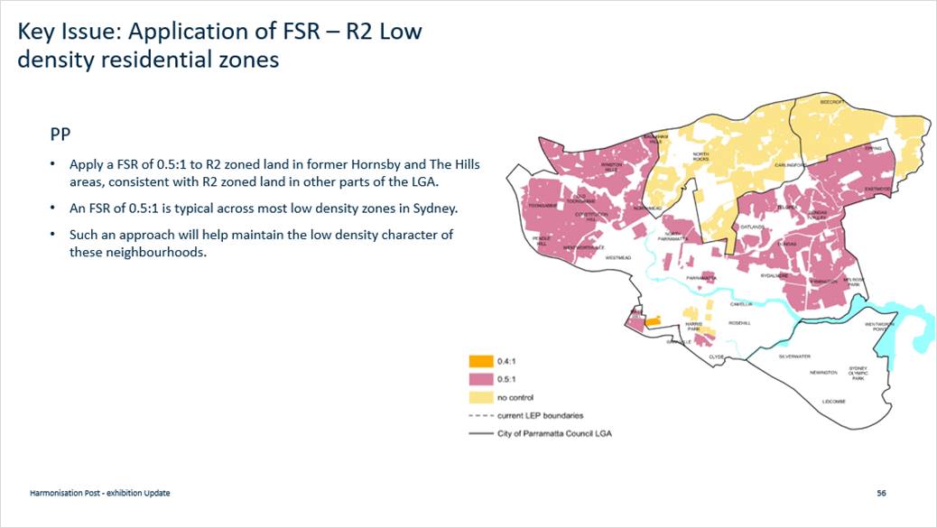
145. A total of 10 objections were made in relation to this issue. Concerns were raised relating to possible loss of development potential, including current development matters and the potential for more legal challenges in Court. Claims were made that FSR in excess of 0.5:1 could be achieved in locations where there is currently no FSR available.
Response
146. The reasons it is important to apply an FSR are discussed in the response in the previous section that deals with the application of the FSR in the R4 zone.
147. The purpose of the LEP Harmonisation Planning Proposal is to consolidate former LEPs and provide consistent land use and development controls across the LGA. It is Council’s intent to apply a FSR of 0.5:1 to all R2 zoned land across the LGA for consistency and provide greater certainty of development outcomes for the community compared to what was previously provided in the former The Hills and Hornsby planning controls where no FSR was specified.
148. It is acknowledged that in some cases sites may have been able to achieve a FSR greater than the 0.5:1 proposed but 0.5:1 is a commonly used density for low density zones across Western Sydney and requests for variations can still be made as part of the development application process where it can be justified on a case by case basis. In order to retain some consistency in the policy framework the requests for Council to apply a different FSR to areas formerly in the hills and Hornsby are not supported.
Key Issue 15 - Requests for Upzonings to Rezone Site from R2 to R3 or R4 to Allow Greater Development Potential
149. Council received 11 submissions seeking to rezone sites from R2 to either R3 or R4 to increase the permitted density and allow owners sites to be redeveloped. Many of these are in Epping but requests in other parts of the LGA were also submitted. The most common justification was that Council should be giving more opportunity to landowners and making better use of transport infrastructure to increase housing supply by rezoning sites to R3 or R4.
Response
150. Proposals to rezone sites to R3 or R4 across the LGA are not supported for the following reasons:
• The Harmonisation Planning Proposal objective is not to introduce new policy positions but to consolidate the various LEPs that apply and retain a policy neutral setting
• It is not appropriate for the Harmonisation Planning Proposal process to increase densities on specific sites without a detailed assessment undertaken via a Planning Proposal process with proper neighbour consultation. Amending the zoning without a more robust process is not appropriate
• Even if the Harmonisation Planning Proposal was seeking to consider increasing the quantity of R3 and/or R4 zoned land the proposals put forward are not consistent with Council’s recently endorsed Housing Strategy and are unlikely to be supported on planning merit grounds
• The proposals to increase density in Epping are not supported due to traffic constraints. The only rezoning of land to R4 in Epping being considered are those already being progressed via separate processes following the Epping Planning Review completed in 2018.
CHANGES TO THE PLANNING PROPOSAL, DRAFT PLEP 2021 AMENDMENT INSTRUMENT AND DRAFT PLEP 2021 AMENDMENT MAPS
151. As a result of the feedback received during the exhibition of the Harmonisation Planning Proposal documentation should only be amended to include the changes where detailed above and described in Attachment 1 Table 1. Other minor changes not arising from submissions will be made to deal with the issues identified below.
152. The changes to the Harmonisation PP documentation have been informed by:
· Minor drafting errors / technical changes. In this regard it is recommended that two minor mapping errors will be corrected on land at Dunrossil Avenue and 725 Blaxland Road, Epping. These changes have no policy impacts and simply resolve errors identified on the maps
· Changes arising from new State Government policy introduced since the commencement of the exhibition period of an administrative nature that do not change any policy settings.
· Changes from Site Specific Planning Proposals that have been finalised since the commencement of the Harmonisation Planning Proposal exhibition period.
153. It is proposed to update the name of the written instrument to include 2021, in anticipation of its finalisation this year.
NSW Government’s Flood Prone Land Package
154. The DPIE has updated a package of materials relating to the management of flood-prone land. The package commences on 14 July 2021 and includes two new standard instrument LEP clauses (one mandatory and one optional). The mandatory ‘Flood Planning’ LEP clause applies to land within the Flood Planning Area (FPA), being land below the Flood Planning Level. A SEPP amendment will introduce this new mandatory clause and replace Council’s existing flood planning clause. In the Draft PLEP 2021 Amendment Instrument Harmonisation LEP at Attachment 8, this new mandatory clause will replace draft Clause 6.3 Flood Planning.
155. Councils can also express an interest to DPIE by 30 June 2021 about whether they want the new optional ‘Special Flood Considerations’ LEP clause to be included in their LEP. This optional LEP clause applies to land between the FPA and the Probable Maximum Flood (PMF) and is expected to be introduced via a second SEPP amendment for interested councils sometime later this year. Given the timing of the commencement of the NSW Government’s flood prone land package and this report to Council seeking endorsement to forward the Harmonisation Planning Proposal to the Department for finalisation, inclusion at this time of the new optional ‘Special Flood Considerations’ LEP clause is not possible. Following proper consideration of the new optional ‘Special Flood Considerations’ LEP clause by Council’s Floodplain Risk Management Committee, Council officers and Councillors, the new clause can be investigated for potential application in the LGA at any time via a Council-initiated site-specific Planning Proposal process.
156. The other materials within the updated flood-prone land package do not have direct implications for Council’s endorsement of the Harmonisation Planning Proposal.
PARRAMATTA LOCAL PLANNING PANEL
157. Council resolved on 14 May 2018 to refer Planning Proposals to the Local Planning Panel (LPP) where a submission has been received during the public exhibition process, which requests that the Planning Proposal be amended. The Panel provides advice to Council on whether the Planning Proposal should be amended and whether or not to forward it to the Department of Planning, Industry and Environment for finalisation.
158. The LPP met on 29 June 2021 and considered a report on the Harmonisation Planning Proposal that was consistent with this report and its recommendations. In total, there were 13 speakers that addressed the LPP meeting. The minutes of the LPP meeting are at Attachment 16.
159. The Panel supported the Planning Proposal being forwarded to the Department of Planning, Industry and Environment in the form recommended by Council Officers. However, the Panel also recommended that Council give further consideration to the following two matters and that they be added to the list of items in Attachment 1 identified as “Changes that have merit for further investigation - via Decision Pathway 3 – Orange):
· To undertake further research of the constraints mapping related to an area at Winston Hills located immediately west of Windsor Road (shown outlined in yellow in Figure 4 of this report); and
· To re-examine the approach to permitting Places of Public Worship in the R2 Residential Low Density zone.
160. If Council supports the approach recommended by the LPP, the Planning Proposal can proceed without change and the two items will then be addressed in future planning reviews as part of the “Orange” Pathway as set out Attachment 1.
NEXT STEPS AND TIMING
161. Should Council endorse the recommendation to finalise the Harmonisation PP, it will be updated with any further changes as resolved by Council, and then it will be forwarded to the DPIE with a request that it be finalised and that the PLEP 2011 Amendment be made in accordance with section 3.36 of the Environmental Planning and Assessment Act 1979. This will include legal drafting of the amending PLEP 2011 instrument by the NSW Parliamentary Counsel’s Office and technical reformatting of maps to relevant map tile sheets to fit the PLEP 2011. Council will be notified once the PLEP 2011 Amendment has been made by the DPIE.
162. If the recommendation is endorsed, it is proposed that a subsequent planning proposal will be prepared to address the various matters identified for progression under Decision Pathway 3. Councillors will be briefed on the program and content for a “housekeeping” planning proposal in late 2021.
CONSULTATION & TIMING
Stakeholder Consultation
163. As noted above, the exhibition process developed for the Harmonisation PP is outlined in the Community Engagement Report contained within Attachment 2 to this report.
164. The following stakeholder consultation has been undertaken in relation to this matter:
|
Date |
Stakeholder |
Stakeholder Comment |
Council Officer Response |
Responsibility |
|
Discussion Paper exhibition from 21 January – 4 March 2019 |
· Landowner, Residents and individuals · Public Authorities, Service Providers and Elected Officials · Institutions, Organisations, and Consultants |
A total of 539 submissions were received (222 written and 317 survey responses). |
Stakeholder feedback informed the preparation of the Harmonisation planning proposal. |
City Planning |
|
PP exhibition from 31 August 2020 to 12 October 2020 |
Landowner, Residents and individuals
|
A total of 285 submissions were received. |
See Appendix A of the Community Engagement Report contained within Attachment 3 to this report |
City Planning |
|
PP exhibition from 31 August 2020 to 12 October 2020 |
Public Authorities, Service Providers and Elected Officials
|
A total of 21 submissions were received. |
See Appendix B of the Community Engagement Report contained within Attachment 4 to this report |
City Planning |
|
PP exhibition from 31 August 2020 to 12 October 2020 |
Institutions, Organisations, and Consultants
|
A total of 14 submissions were received. |
See Appendix C of the Community Engagement Report contained within Attachment 5 to this report |
City Planning |
Councillor Consultation
165. The following Councillor consultation has been undertaken in relation to this matter:
|
Date |
Councillor |
Councillor Comment |
Council Officer Response |
Responsibility |
|
21 November 2018 |
Councillor Workshop |
Councillor Workshop on Discussion Paper |
Consideration by Council officers as part of review |
City Planning |
|
26 November 2018 |
Council Meeting |
Council endorsed the Discussion Paper (for Public Exhibition). |
Consideration by Council officers as part of review |
City Planning |
|
15 July 2019 |
Councillor Workshop |
Councillors asked a series of questions about the Harmonisation PP, submissions received and process matters. |
Councillor feedback informed the preparation of the Harmonisation planning proposal. |
City Planning |
|
11 November 2019
|
Council Meeting |
Following LPP, consideration on 8 October 2021 (see Table 1 in this report), Council resolved to endorse a Planning Proposal |
Council staff sought Gateway determination from DPIE for the Harmonisation PP |
City Planning |
|
17 May 2021 |
Councillor Workshop |
Councillors asked a series of questions about the, submissions received and process matters |
Councillor feedback informed the finalisation of the Harmonisation planning proposal. |
City Planning |
166. Briefing Notes were sent to Councillors at key milestones during the exhibition/post-exhibition process.
CONSISTENCY WITH LOCAL STRATEGIC PLANNING STATEMENT
167. The City of Parramatta’s Local Strategic Planning Statement (LSPS) “City Plan 2036” came into effect on 31 March 2020. The LSPS sets out the 20-year land use planning vision for the City of Parramatta local government area (LGA) and responds to broader priorities identified in the Central City District Plan and Council’s Community Strategic Plan. The planning priorities are supported by policy directions and actions to guide future changes to the City’s land use planning controls.
168. The LSPS endorsed in 2020, contains Action A30 (under LSPS Planning Priority 5 p.58) to “finalise the review of dual occupancy and medium density residential zone provisions for Government’s consideration as part of the LEP Harmonisation Project.” The zone provisions have been reviewed as part of the Harmonisation PP and draft PLEP consistent with Council’s LSPS action
LEGAL IMPLICATIONS FOR COUNCIL
169. There are no immediate legal implications as a direct consequence of the public exhibition and consideration of the Harmonisation PP for finalisation.
170. The Harmonisation PP has been prepared and exhibited in accordance with the Environmental Planning and Assessment Act 1979 (EP&A Act) and the NSW DPIE’s A Guide to Preparing Planning Proposals and considers State and local planning strategies.
FINANCIAL IMPLICATIONS FOR COUNCIL
171. In relation to the Harmonisation PP finalisation:
a. The costs associated with the post exhibition review and finalisation of the Harmonisation PP, including the requested changes supported by Council officers, are funded from the existing City Planning budget.
b. Should additional changes be made to the Harmonisation PP (via Council resolution) that trigger a re-exhibition, depending on the nature and amount of changes, this would cost at least $50,000, which has not been included in the 2021/22 budget.
|
|
FY 20/21 |
FY 21/22 |
FY 22/23 |
FY 23/24 |
|
Operating Result |
|
|
|
|
|
External Costs |
Nil |
Nil |
Nil |
Nil |
|
Internal Costs |
|
|
|
|
|
Depreciation |
|
|
|
|
|
Other |
|
|
|
|
|
Total Operating Result |
Nil |
Nil |
Nil |
Nil |
|
|
|
|
|
|
|
Funding Source |
N/A |
N/A |
N/A |
N/A |
|
|
|
|
|
|
|
CAPEX |
|
|
|
|
|
CAPEX |
|
|
|
|
|
External |
|
|
|
|
|
Internal |
|
|
|
|
|
Other |
|
|
|
|
|
Total CAPEX |
Nil |
Nil |
Nil |
Nil |
|
|
|
|
|
|
|
Funding Source |
N/A |
N/A |
N/A |
N/A |
172. The financial implications of the changes to the Harmonisation PP that are identified in this report to have ‘Merit for Further Investigation’ (under Decision Pathway 3 - Orange) to be progressed through a separate “Housekeeping” planning proposal at a later stage will be the subject of a separate briefing to Councillors. Should changes be made (via Council resolution) which increase the scope of works that fall under Decision Pathway 3, these will be taken into account in that briefing.
Shari Driver
Land Use Planning Manager
Michael Tzimoulas
Executive Director Corporate Services
David Birds
Acting Executive Director, City Planning & Design
Brett Newman
Chief Executive Officer
|
1⇩ |
SUMMARY OF COUNCIL OFFICER RECOMMENDATIONS |
4 Pages |
|
|
2⇩ |
COMMUNITY ENGAGEMENT REPORT (Excluding appendices) |
16 Pages |
|
|
3⇩ |
COMMUNITY ENGAGEMENT REPORT - Appendix A - Landowner, Resident and Individual Submission Summaries |
147 Pages |
|
|
4⇩ |
COMMUNITY ENGAGEMENT REPORT - Appendix B - Institutions, Organisations and Consultants Submission Summaries |
23 Pages |
|
|
5⇩ |
COMMUNITY ENGAGEMENT REPORT - Appendix C - Public Authorities and Services Providers Submission Summaries |
19 Pages |
|
|
6⇩ |
Community Views About Dual Occupancy Development - Map |
1 Page |
|
|
7⇩ |
PLANNING PROPOSAL (Excluding appendices) |
124 Pages |
|
|
8⇩ |
PLANNING PROPOSAL - Appendix 1 - Proposed Draft LEP 2021 |
155 Pages |
|
|
9⇩ |
PLANNING PROPOSAL - Appendix 2 - Comparison of LEP Instruments |
24 Pages |
|
|
10⇩ |
PLANNING PROPOSAL - Appendix 3 - Comparison of LEP Land Use Tables |
59 Pages |
|
|
11⇩ |
PLANNING PROPOSAL - Appendix 4 - Land Application Map |
1 Page |
|
|
12⇩ |
PLANNING PROPOSAL - Appendix 8 - Proposed Mapping |
33 Pages |
|
|
13⇩ |
PLANNING PROPOSAL - Appendix 9 - Quantitative Analysis of Proposed Changes to Residential Zones |
16 Pages |
|
|
14⇩ |
PLANNING PROPOSAL - Appendix 10 - Gateway Determination |
1 Page |
|
|
15⇩ |
Local Planning Panel Report (excluding attachments and appendices) |
27 Pages |
|
|
16⇩ |
Minutes of the Local Planning Panel Meeting - 29 June 2021 |
3 Pages |
|
REFERENCE MATERIAL
|
COMMUNITY ENGAGEMENT REPORT (Excluding appendices) |
Exhibition of the draft parramatta Local Environmental plan
Community Engagement Report
June 2021
1. Introduction
2. Community Engagement
3. Feedback from Discussion Paper
4. Feedback from Exhibition Period
5. Conclusion
Appendix A – Resident and Individual Submission Summaries
Appendix B – Institutions, Organisations and Consultant Submission Summaries
Appendix C – Public Authorities, Service Providers and Elected Officials Summaries
1.1. Background
This Community Engagement Report forms an attachment to both a Local Planning Panel and Council report, each of which report on the feedback from the exhibition of the Harmonisation Planning Proposal.
City of Parramatta Council sought to harmonise the existing planning controls that apply across the City of Parramatta. The draft Local Environmental Plan (LEP) will replace the existing LEPs that apply within the Local Government Area (LGA) and will be the primary legal planning document for guiding development and land use decisions made by Council.
This report addresses the communications and engagement methods that were implemented during the exhibition period. This report also provides an overview of the feedback received during the exhibition period. At the end of the report, there are 3 separate appendices that provide a detailed summary of submissions by submitter type along with the corresponding Council Officer response, refer to Appendices A, B and C of this report.
1.2. Community Communication and Engagement Plan
A Community Communication and Engagement Plan was prepared as an internal tool to determine the appropriate type of engagement tools to ensure statutory compliance with the Environmental Planning and Assessment Act 1979 as well as the Environmental Planning and Assessment Regulation 2000.
The Communication Plan proposed a range of engagement mechanisms to ensure compliance with the above legislation and Strategy. Furthermore, Council’s City Planning Team worked closely with Council’s City Engagement Team to deliver the consultation mechanisms in the Plan. These mechanisms are discussed in the following section.
The term ‘community’ includes (but is not limited to) residents, landowners, businesses, workers, visitors, interest groups, non-government organisations, non-for-profit organisations, the development industry and planning proposal applicants, other industry sectors and stakeholders, including peak industry groups and State public authorities.
2.2. Engagement Timeframe
The exhibition period commenced on 31 August 2020 to 12 October 2020 running for a six (6) week period.
2.3. Engagement Methods
The levels of participation for the engagement program (based on the IAP2 Spectrum) were ‘Inform’ and ‘Consult’. The table below outlines the objectives of the program for each engagement level.
|
Engagement Level |
Objectives |
|
Inform |
Communicate that City of Parramatta Council is harmonising the Local Environmental Plan across the LGA |
|
Consult |
Obtain feedback on LEP. Identify any issues with planning proposal. |
As noted, an internal Communication Plan outlined a number of mechanisms to promote the public exhibition and provide the opportunity for feedback on the Harmonisation Planning Proposal. In light of COVID-19, the engagement tools recommended addressing social distancing requirements and any relevant statutory requirement. Therefore, Council relied on online methods of promotion and direct notification to impacted residents.
The notification mechanisms and engagement tools that were implemented are listed below:
1. Notification Letters – mail out
2. Notification Email
3. City of Parramatta Corporate Website pages
4. Participate Parramatta engagement portal
5. Newspaper advertisement
6. Media Release by Council’s Media Team
7. Social media
8. Booked phone calls referred to as ‘Phone a Planner’ sessions
9. Hard copies of the exhibition package at the Contact Centre and Libraries
10. Electronic Direct Mail (EDM’s sent)
Community members could provide feedback via an online submissions form, email and post. The consultation processes summarised above and described in detail below resulted in 320 submissions being lodged with Council.
2.3.1. Notification Letters - mail out
A letter notifying residents and occupiers of the exhibition was distributed to 63,652 addresses.
There were several different versions of the letter, tailored to the zoning of the property and identifying the key changes of relevance.
2.3.2. Notification Emails
A series of emails were delivered to relevant stakeholders to notify them of the commencement of the exhibition. The series of notification emails relied on an internal stakeholder list formulated from previous submissions and enquiries regarding the draft LEP Harmonisation project. In accordance with Condition 4 of the Gateway Determination, Council officers also notified the following State Agencies:
· Greater Sydney Commission;
· NSW Rural Fire Service;
· Environment, Energy and Science;
· Transport for New South Wales;
· Department of Premier and Cabinet – NSW Heritage.
2.3.3. City of Parramatta Website
There were a range of pages on the corporate City of Parramatta website used to promote the engagement opportunity and direct readers to the Participate Parramatta project page.
|
Page |
Page views |
|
Project Page |
816 |
|
Media Release page |
218 |
|
Community Engagement Page |
537 |
The engagement opportunity was also promoted via the slider on the City of Paramatta landing page with 147 clicks to the project page.
2.3.4. Participate Parramatta
The project was featured on the platform from 14 September 2020, resulting in 14,231 views during the exhibition period. The page included the following:
· A submission form
· Proposed Plans
· An interactive map showing the current planning controls and the proposed changes
· Summary documents
· Translated documents
· After hours phone booking opportunity via Calendly
· Contact details for the Land Use Planning team
|
Events on project page |
Total |
|
Page views |
14,231 |
|
Unique page views |
7,717 |
|
Total document download |
3,308 |
|
Online submissions via the page |
189 |
|
Followers of project |
110 |
|
Bookings via Calendly |
9 |
|
Interactive maps |
Views |
|
Dual Occupancy Prohibition Map |
5,427 |
|
Changes to land Use Zoning |
1981 |
|
Changes to height Limits |
690 |
|
Changes to Floor Space Ratio Controls |
589 |
|
Changes to Subdivision Lot Size Controls |
758 |
|
Changes to Biodiversity Land Maps |
279 |
|
Changes to Riparian Land Maps |
233 |
2.3.5. Newspaper advertisement
An advertisement promoting the exhibition was put in the Sydney Morning Herald on 31 August 2020.
2.3.6. Media Release
A media release was published by City of Parramatta Council on 1 September 2020.
2.3.7. Social media channels
The exhibition period for the draft LEP Harmonisation project was promoted across Council’s social media channels, including the City of Parramatta Facebook (37,403 followers), Twitter (8,758 followers) and Participate Parramatta Facebook (6,992 followers) account. This means that the opportunity to provide feedback was presented to 53,153 social media followers and reached approximately 36,894 people, cumulating in 363 clicks through to the project page.
2.3.8. Electronic Direct Mail (EDM’s sent)
Prior to and at the commencement of the consultation period, a total of three (3) electronic direct mail or EDM’s were sent to a total of 98,975 recipients.
1. Participate Parramatta Research Panel newsletter
2. City of Parramatta’s ePulse newsletter
3. Economic Development Business Newsletter
|
EDM |
Date |
Total recipients |
|
City Engagement: Panel |
02/09/2020 |
9971 |
|
ePulse (September edition) |
08/09/2020 |
56,682 |
|
Economic Development newsletter |
September |
32,322 |
|
Bushcare E-Newsletter |
September |
1,023 |
Resources
To assist the community with navigating through the exhibition material, Council Officers prepared supporting documentation to the Planning Proposal. Council’s City Engagement team have advised that there was a total of 3,308 downloads across the 17 documents.
|
|
Document |
Downloads |
|
1 |
Zoning Map Summary of Changes |
388 |
|
2 |
MLS Map Summary of Changes |
233 |
|
3 |
Item 49 20190819 |
64 |
|
4 |
FSR Map Summary of Changes |
137 |
|
5 |
Item 48 2020717 |
59 |
|
6 |
HOB Map Summary of Changes |
113 |
|
7 |
Item 46 20200724 |
761 |
|
8 |
Additional Permitted Uses Map Summary of Changes |
269 |
|
9 |
Key Sites Map Summary of Changes |
211 |
|
10 |
Land Reservation Acquisition Map |
0 |
|
11 |
Heritage Map Summary of Changes |
321 |
|
12 |
Foreshore Building Line Map Summary of Changes |
0 |
|
13 |
Land Reservation Acquisition Mao Summary of Changes |
210 |
|
14 |
Land Zoning Map Summary of changes |
1 |
|
15 |
LEP Community Summary English |
119 |
|
16 |
Dual occupancies fact sheet English |
323 |
|
17 |
LEP Fact Sheet English |
99 |
Examples of Engagement Tools
Please refer to Figure 1,2,3 and 4 for examples of the engagement tools that were available to the community.
![]()
![]() Webpage on the City of Parramatta Website
Webpage on the City of Parramatta Website
Participate Parramatta, Land Use Planning Harmonisation Webpage
Figure 2 - Participate Parramatta webpage
Sydney Morning Herald Public Notice, 31 August 200
![]()
![]()
![]()
![]() City of Parramatta Media Release, 1 September 2020
City of Parramatta Media Release, 1 September 2020
3. Feedback from Discussion Paper
3.1. Harmonising our land use planning framework, Discussion Paper January 2019
The Discussion Paper presented options for harmonising planning controls. Council exhibited from 21 January to 4 March 2019. A total of 539 submissions were received (464 excluding duplicates)
At its Council Meeting on 11 November 2019, Council considered a report and decided to:
1. Proceed with proposed dual occupancy prohibition areas. (Option 1)
2. Extend prohibition of dual occupancies to include R2 zoned land between Marsden and Midson Road, Epping. (taking into LPP recommendation modified Option 1)
3. Make other changes to the draft PP
4. Council formally resolved (Item 18.2, Resolution 2499) as follows:
a. That Council endorse the Planning Proposal – Consolidated Parramatta Local Environmental Plan (included at Attachments 4 and 5), for submission to the Department of Planning, Industry and Environment with a request for a Gateway Determination, and subject to the following amendments being incorporated:
i. Retain the existing height controls applying to R3 Medium Density Residential zoned land currently subject to Parramatta LEP 2011, and amend the Height of Building Map to apply a height limit of 11 metres to R3 zoned land across the remainder of the City of Parramatta LGA.
ii. Remove Items 13A and 13B in Part 4 of the Planning Proposal relating to the rezoning of various places of public worship from R2 Low Density Residential to SP1 Special Activities.
iii. Amend the Zoning map to rezone existing places of public worship adjoining R2 Low Density Residential zoned land from SP1 Special Activities to R2 Low Density Residential.
iv. Amend the Zoning Map to rezone land in Northmead bounded by Fletcher Street, Campbell Street and Murray Street from R3 Medium Density Residential to R2 Low Density Residential, and apply the corresponding height, FSR and minimum subdivision lot size controls consistent with that proposed for the adjoining R2 zoned land, to reflect the low -density character of the neighbourhood. Further, that this land be included on the Dual Occupancy Prohibition Map.
v. Amend the Zoning Map to rezone land at 34 to 62 Felton Road, Carlingford from R3 Medium Density Residential to R2 Low Density Residential to align with the R2 zoning on the north side of the road, and apply the corresponding height, FSR and minimum subdivision lot size controls consistent with that proposed for the adjoining R2 zoned land. Further, that this land be included on the Dual Occupancy Prohibition Map
vi. Amend the Dual Occupancy Prohibition Map to include all R2 Low Density Residential zoned land between Marsden and Midson Roads.
b. That Council note the outcomes of the public exhibition of the Discussion Paper, outlined in the Consultation Report that is included as Appendix 5 to the Planning Proposal.
c. That Council authorises the CEO to correct any minor policy inconsistencies and any anomalies of an administrative nature relating to the Planning Proposal that may arise during the Planning Proposal process.
d. Further, that Council note the Local Planning Panel’s advice, provided at Attachment 6, except that it includes a recommendation that, post Gateway, there is greater targeted public consultation around the topical matters, including dual occupancy. Given the extensive consultation that has been undertaken to date, the Planning Proposal recommends targeted consultation including notification to those who made a submission on the Discussion Paper or have registered an interest in the project, as well as to landowners affected by a change in zoning, height, FSR or minimum lot size controls.
As discussed in the Local Planning Panel Report, the feedback from the Discussion Paper together with the Council resolution then informed the Preparation of a Planning Proposal for public exhibition. The next section of this report summarises the feedback from the Planning Proposal and draft LEP exhibition phase.
4. Feedback from Exhibition Period
4.1. Formal Feedback – Submissions
Formal feedback on the exhibition of the Harmonisation Planning Proposal consistent with the community participation requirements established by the EP&A Act resulted in a total of 320 submissions (includes multiple submissions from one submitter) being received by Council. Due to the large number of received submissions, the submissions have been categorised into the following:
· Residents and Individuals: 285 Submissions,
o A detailed summary of the submissions received from Residents and Individuals and Council Officer Responses is provided at Appendix A.
· Institutions, Organisations and Consultants: 21 Submissions,
o A detailed summary of the submissions from Institutions, Organisations and Consultants and Council Officer Response is provided at Appendix B.
· Public Authorities, Service Providers and Elected Officials: 14 Submissions.
o A detailed summary of the submissions on behalf of Public Authorities, Service Providers and elected Officials. The Council Officer Response is provided at Appendix C.
The feedback received from the community during the formal exhibition period is discussed with a detailed summary of submissions in each category along with the corresponding Council Officer response, in Appendices A to C of this report and the Local Planning Panel report.
The feedback received during the exhibition phase has informed changes to the Harmonisation Planning Proposal documentation including the planning proposal, Draft LEP provisions and Draft LEP Maps. These changes are detailed in the Local Planning Panel report for the meeting of 29 June2021 and the follow up Council Report of 12 July 2021.
The Participate Parramatta and City of Parramatta websites will be regularly updated to inform the public of reporting processes and next steps of the Harmonisation Planning Proposal.
Appendix A – Resident and Individual Submission Summaries
[Provided under separate cover – attached to the Local Planning Panel Report]
Appendix B – Institutions, Organisations and Consultant Submission Summaries
[Provided under separate cover – attached to the Local Planning Panel Report]
Appendix C – Public Authorities, Service Providers and Elected Officials Submission Summaries
[Provided under separate cover– attached to the Local Planning Panel Report ]
|
COMMUNITY ENGAGEMENT REPORT - Appendix A - Landowner, Resident and Individual Submission Summaries |
APPENDIX A – Landowners (including Places of Public Worship), Residents and Individuals
Where a Council Officer response deals with an issue raised by an earlier submission, a statement is provided that acknowledges the submission and provides details of the Submission Row where a response to the same or similar issue can be found. For example, “The issues raised by the submitter are noted and addressed in the Council Officer response at Row 8”.
In responding to the submissions in this table, the relevant Decision Pathway is provided to indicate the Council officer’s position with respect to the issues raised. Where a response to a submission references a previous response, the Decision Pathway has been repeated.
During the review of submissions, Council has identified key issues that have either been frequently raised, or require a unique response. These key issues are addressed in The Local Planning Panel Report.
To ensure the privacy of submitters, names and street numbers have been withheld.
|
Tip: To find a particular submission: search for the Street Address (e.g. “Tarragundi Road”) or an issue you raised in your submission (e.g. “Dual Occupancy”, “Minimum Lot Size”, “Places of Public Worship” etc) using the Control ‘F’ function. |
||||
|
Row No. |
Submitter Address |
Topic |
Summary of Submission |
Council Officer Response |
|
1. |
Tarragundi Road, Epping |
Dual occupancy development |
Submitter notes that their site is around 700sqm and they are getting into retirement age, so it will be hard for them to maintain the land. Submitter maintains it would be beneficial to be able to subdivide the land for dual occupancies. |
Council understands there are views from submitters that are for and against dual occupancy development in the Parramatta LGA. The LEP Harmonisation PP primarily proposes to continue prohibiting dual occupancy development where it is currently prohibited under the existing controls. However, as part of the Harmonisation Planning Proposal a dual occupancy constraints analysis was undertaken for residential areas, that has identified suburbs which are constrained and generally unsuitable for dual occupancy development. The constraints analysis is informed by the capacity analysis undertaken as part of Council’s endorsed Local Housing Strategy 2020. This topic is addressed in further detail in The Local Planning Panel Report. Proposed changes to the exhibited PP on this matter are not supported based on the strategic planning merit assessment and long-term land use planning objectives of Council. Decision Pathway – 2: Not supported. |
|
2. |
Cottee Drive, Epping |
Dual occupancy development |
Submitter states that landowners should continue to enjoy choice between single or dual occupancy living, and notes that the street block has never been overdeveloped like other areas. |
This matter has been addressed at Row 1. This topic is addressed in further detail in The Local Planning Panel Report. Decision Pathway – 2: Not supported. |
|
3. |
Pennant Hills Road, Carlingford |
Dual occupancy development |
Submitter opposes proposed prohibition of dual occupancies for the following reasons: · City of Parramatta Council is the only council to prohibit dual occupancy in NSW. · The prohibition would significantly reduce the value of their land and upset their plans to redevelop in the future. · Submitter's site is 700sqm, which would allow 350sqm per dwelling, which is enough for 4 bedrooms. |
This matter has been addressed at Row 1. This topic is addressed in further detail in The Local Planning Panel Report. Decision Pathway – 2: Not supported. |
|
4. |
Buyuma Street, Carlingford |
Dual occupancy development |
Submitter opposes proposed dual occupancy prohibition for the following reasons: · Jointly purchased property with a site area of 1,119 sqm with the intention of developing a dual occupancy at a later date. · Submitter has not had the opportunity to develop a dual occupancy as their livelihoods have been affected by COVID-19. · Prohibition will reduce property value. · Dreams of building a dual occupancy/owning a home will be lost. · Houses on Buyuma Street, Carlingford have large land sizes which are capable of accommodating dual occupancy development. · Neighbours on either side have recently built dual occupancies which sets a precedent in the area. |
This matter has been addressed at Row 1. This topic is addressed in further detail in The Local Planning Panel Report. Decision Pathway – 2: Not supported. |
|
5. |
Essex Street, Epping |
Minimum lot size |
Submitter opposes proposal to increase the minimum lot size in the former Hornsby LGA from 500sqm to 550sqm. Reasons include: · Purchased large property with intent to subdivide into two lots. · Paid more money for the land due to its size. However, will be unable to subdivide under the draft Local Environmental Plan (LEP). · Proposed change will significantly reduce the value of their property and place a negative equity burden on young families. · With COVID-19, land owners are in negative equity and this change will further reduce property value. · Proposed changes will have huge financial and lifelong ramifications |
Council understands there are concerns over the proposed increase to the minimum lot size in the former Hornsby LGA. Council has sought to balance the long term strategic planning objectives and provide consistent planning controls for residential land across the LGA. This topic is addressed in further detail in The Local Planning Panel Report. Proposed changes to the exhibited PP on this matter is not supported based on the strategic planning merit assessment and long-term land use planning objectives of Council. Decision Pathway – 2: Not supported. |
|
6. |
Kawana Close, Epping |
Dual occupancy development |
Submitter opposes proposed dual occupancy prohibition, particularly in Epping. Reasons include: · Does not consider the future urban growth in Epping. · The draft proposal is 'status of quo' and 'sit back and see what happens' after 5 years of Council amalgamations. · No Council has proposed this option amid COVID 19. · The proposed prohibition does not consider 'right location' for the future urban growth. · Under the massive infrastructure provisions (e.g. Sydney Metro Northwest) in Epping, transit-oriented development will require more homes to accommodate the increasing local commuters and migrants in the next 5 years. · Epping is one of the fastest growing areas in Sydney in terms of population and house prices. · Housing provision should be in the right place and I can't think of any better place to accommodate increasing population and housing other than Epping. · Epping is an edge city and local growth pole in the northwest corridor of Sydney under Sydney Metropolitan Planning Strategy. · Epping is a completely different area than 5 years ago.
|
This matter has been addressed at Row 1. This topic is addressed in further detail in The Local Planning Panel Report. Decision Pathway – 2: Not supported. |
|
7. |
Haywood Street, Epping |
Dual occupancy prohibition areas |
Two identical submissions received for this property, objecting proposed dual occupancy prohibition for the following reasons: · Council has disregarded the majority opinion of residents who supported fewer prohibition areas during early consultation on the Harmonisation Discussion Paper. · Most local residents would like to see dual occupancies being allowed in Epping and Carlingford. · Dual occupancies should be permitted in R2 zoned areas as a better solution to new high rise apartments. · High rise apartments have oversupplied the needs of units for the next 5 years, which can only support small living areas and very low living quality. Traffic congestion is caused by high density development, particularly near train stations. · The proposal is inconsistent with the Ministerial Direction 3.1, as it includes a number of amendments which will reduce the supply and diversity of housing in the LGA, particularly the expansion of areas where dual occupancies will be prohibited. · Council should listen to the local residents' opinions and needs to improve in order to gain the confidence and votes back from local residents. · Submitter also notes support for the NSW Government's Low Rise Medium Housing Code.
|
This matter has been addressed at Row 1. This topic is addressed in further detail in The Local Planning Panel Report. Decision Pathway – 2: Not supported. |
|
8. |
Dandarbong Avenue, Carlingford |
Dual occupancy prohibition areas |
Submitter opposes proposed dual occupancy prohibition for the following reasons: · Despite the survey results from consultation on the Harmonisation Discussion Paper in 2019 which indicated that 65% of submissions preferred fewer prohibition areas, Council has decided to increase the prohibition areas to almost double of the previous size. · It is understood that the Council area has constraints, however rather than dealing with the constraints by investing more into the local infrastructure, Council has decided to prohibition dual occupancies. · Prohibition is unfair and disadvantages those with large lots. · The large lot sizes are underutilised and can impact future planning of the area. · To ensure fairness to all lot owners, Council should consider those who have maintained a large lot size but will be deeply affected and impacted by this proposal. · Dual occupancy can be controlled by setting larger minimum lot sizes (e.g. 800-1,000sqm). This will easily achieve reduced development in low density areas and provide large lot owners a fair chance should they wish to develop their property at a reduced capacity. · Carlingford is a very attractive area to many young families and the Council should encourage more development including low density housing and invest in more infrastructure and public transportation, rather than restricting the developments.
|
This matter has been addressed at Row 1. This topic is addressed in further detail in The Local Planning Panel Report. Decision Pathway – 2: Not supported. |
|
9. |
Bligh Street, Silverwater |
Request for site-specific rezoning |
Submitter requests for site-specific rezoning for 20 Bligh Street Silverwater and surrounds from B6 Business Enterprise to either B4 Mixed Use or residential.
|
The purpose of the LEP Harmonisation Planning Proposal (PP) is to consolidate former LEPs and provide consistent land use and development controls across the LGA. Site specific rezonings are outside the scope of the LEP Harmonisation PP. The landowner is to consult with Council with merits for a separate proponent-led planning proposal and demonstrate consistency with the Parramatta Local Strategic Planning Statement (LSPS). Proposed changes to the exhibited LEP Harmonisation PP on this matter is not supported as the proposal is outside the scope of this planning process. Decision Pathway – 2: Not supported. |
|
10. |
Dandarbong Avenue, Carlingford |
Dual occupancy development |
Submitter requests that the property be exempt from the proposed dual occupancy prohibition. Alternatively, it is requested that Council exempt the small pocket of land encompassing Illarangi Street, Dandarbong Avenue and Buyuma Avenue. Reasons include: · Landowner recently purchased property with intent to build a dual occupancy in the future. Had they known about the proposed prohibition they would not have purchased this land. · Dual occupancy development leads the way in beautifying and improving the safety of the area. · There are comparatively very few knockdown-rebuilds of stand along properties in this area. · Should the proposed dual occupancy prohibition be enforced, it will likely put a considerable halt to growth and improvement of the local area, as investment in other areas would appear more attractive. · Prohibition will reduce land value and land owner will be stuck living in a house they don't want to live in long-term but can't afford to sell at a loss.
|
This matter has been addressed at Row 1. This topic is addressed in further detail in The Local Planning Panel Report. Decision Pathway – 2: Not supported. |
|
11. |
Warwick Road, Dundas Valley |
Dual occupancy development |
Submitter opposes proposed dual occupancy prohibition for the following reasons: · Prohibition would impact the land value of properties in the area. · Prohibition will greatly impact those who were planning to build a dual occupancy. Investors will lose interest in the area, therefore making the older housing stock decrease in value. · Recent dual occupancies have greatly increased the aesthetics and encouraged new families to choose to reside in the area, making the suburb more appealing. · Prohibition will mean that old houses which are unsafe and unsightly will not be given a chance to be re-birthed. Current owners are unlikely to have the funds to rebuild new properties without the income from either selling one or renting it out. · Dual occupancies provide an opportunity for families to live in close proximity to each other and new generations to remain in the local area. Families often work together to provide income and land so they can build houses side-by-side at the cost of buying one house much further west.
|
This matter has been addressed at Row 1. This topic is addressed in further detail in The Local Planning Panel Report. Decision Pathway – 2: Not supported. |
|
12. |
Andrew Place, North Rocks |
Other |
Submitter notes support for all proposed changes in the draft LEP.
|
Support noted. |
|
13. |
Pennant Hills Road, Carlingford |
Request for site-specific rezoning |
Request for rezoning of identified property on Pennant Hills Road, Carlingford from R2 Low Density Residential to R4 High Density Residential. |
This is one of a number of site-specific requests for changes to zoning that increase the development potential in different parts of the LGA. Council’s recently completed Local Housing Strategy has identified areas where increased in housing density and type are appropriate. This site is not within one of those areas identified. Proposed changes to the exhibited LEP Harmonisation PP on this matter is not supported as the proposal is outside the scope of this planning process. Decision Pathway – 2: Not supported. |
|
14. |
Cudal Place, Carlingford |
Other
|
Submitter notes the recent approval of a dual occupancy development in Cudal Place, Carlingford. Submitter unsure why Council approved this development, despite strong opposition from local residents and notes that construction has created amenity impacts for nearby residents. Submitter states that proposed dual occupancy prohibition in the area/street has come too late. |
This matter has been addressed at Row 1. Submitter's concerns are noted, however, the proposed prohibition of dual occupancies in certain areas are not able to be applied retrospectively to approved development. This topic is addressed in further detail in The Local Planning Panel Report. Decision Pathway – 2: Not supported. |
|
15. |
York Street, Epping |
Dual occupancy development |
Submitter opposes proposed dual occupancy prohibition, specifically for identified property at York Street Epping. Submitter questions why York Street remains under Hornsby's previous planning controls, even though it is zoned R2 and is now within City of Parramatta Council's jurisdiction. |
This matter has been addressed at Row 1. This topic is addressed in further detail in The Local Planning Panel Report. Decision Pathway – 2: Not supported. |
|
16. |
Barellan Avenue, Carlingford |
Dual occupancy development |
Submitter supports proposed dual occupancy prohibition areas and believes this is a good and sensible measure to ensure the low density zoning remains true to its name. Submitter notes there has been a proliferation of dual occupancies in their area in recent years, with has corresponded with an increase in traffic and cars parked in the street.
|
Support noted. This topic is addressed in further detail in The Local Planning Panel Report. |
|
17. |
Newington |
Floor space ratio (FSR) |
Submitter opposes FSR decrease in Newington and is concerned a reduction from 0.75:1 to 0.6:1 could prevent landowners from extending their home, which may in turn decrease property value. Submitter also notes that Newington has a high FSR due to small lot sizes and some houses wouldn't fit into an FSR of 0.6:1. |
Council acknowledges the submitter’s request and accepts the identified development in Newington is a unique site-specific community title development with site specific development controls that strictly control built form outcomes on the site. Council has reviewed the proposed development and selected to retain the current FSR control of 0.75:1 in Newington to reflect the existing subdivision pattern, unique community title development form and density of this area. This topic is addressed in further detail in The Local Planning Panel Report. Decision Pathway – 1: Issue addressed; no further decisions required. |
|
18. |
Jenkins Road, Carlingford |
Dual occupancy development |
Submitter opposes blanket prohibition of dual occupancy development for the following reasons: · Blanket prohibition is incongruent with function as a Council and stance on over-development by big developers. · Factors raised for prohibition are remedied by consideration at the DA stage and are part of the assessment. To place a blanket prohibition for the reasons outlined in the Planning Proposal is simply to not perform Council's duties. · Council has allowed the overdevelopment of units in the LGA yet is proposed to put onerous prohibitions on mum and dad owners who may have the potential to subdivide, the rate at which this occurs does not warrant blanket prohibition. · Claim that properties will not lose value is an indefensible position and the rate at which Council charge rates should be reduced. It is impossible to state that a piece of land with dual function is worth the same as one with single function.
|
This matter has been addressed at Row 1. This topic is addressed in further detail in The Local Planning Panel Report. Decision Pathway – 2: Not supported. |
|
19. |
Epping Avenue, Epping |
Dual occupancy development |
Support proposed dual occupancy prohibition. |
Support noted. This topic is addressed in further detail in The Local Planning Panel Report. |
|
20. |
Ross Street, Epping |
Dual occupancy development |
Submitter opposes proposed dual occupancy prohibition for the following reasons: · Dual occupancy should be permitted as applicable in other parts of the Council areas. · Due to current housing shortages and lack of affordable housing/land, dual occupancy development should be allowed on any block of land 600sqm with applicable frontage. · Dual occupancy development will alleviate pressure on current housing demands and more people will be able to live in the area.
|
This matter has been addressed at Row 1. This topic is addressed in further detail in The Local Planning Panel Report. Decision Pathway – 2: Not supported. |
|
21. |
Edenlee street, Epping |
Dual occupancy development |
Submitter supports prohibition of dual occupancies in R2 zones. Submitter requests that Edenlee Street Epping be added to the prohibition map and notes concern about a proposed dual occupancy on neighbouring property, which could have negative impacts on solar access and amenity. |
Support noted. The R2 zoned side of Edenlee Street (where the submitter is located) is already included in the dual occupancy prohibition area. This prohibition does not impact on applications already lodged for consideration. This topic is addressed in further detail in The Local Planning Panel Report. |
|
22. |
Highclere Crescent, North Rocks |
Dual occupancy development |
Submitter notes confidence in Council's proposal to prohibit dual occupancies on certain R2 zoned land and notes that some large homes are able to accommodate several generations of families. However, states a duplex would enable a senior person to remain independent in a purpose built home in a familiar area.
|
Support for dual occupancy prohibition noted. This topic is addressed in further detail in The Local Planning Panel Report. With regard to enabling a senior person to remain independent in a purpose built home it is noted that the Harmonisation PP does not change provisions that allow for Secondary Dwellings (sometimes referred to as “Granny Flats”) to be constructed in many R2 zoned sites under a state government affordable housing policy. |
|
23. |
Raimonde Road, Carlingford |
Dual occupancy development |
Submitter opposes proposed dual occupancy prohibition, particularly in Raimonde Road Carlingford for the following reasons. Personal reasons: · Looking to sell and downsize. Does not want to be pushed into an apartment or townhouse. · Prohibition will deter prospective buyers and significantly reduce the land value. Submitter will also be out of pocket for costs spent to date, even if they take their house off the market. · The proposal will alter future plans to sell and move to a lower maintenance property. Landowner will be required to remain in their house for the foreseeable future. Unfair · Blanket prohibition unfairly penalises landowners with large properties and will drive investment elsewhere. · Disagree that dual occupancy development is inappropriate in this street as the character of the street has changed due to existing dual occupancy development. Now the streetscape has changed, it is unfair to remaining residents who will be unable to benefit from developer interest. · Need to allow sympathetic development · Submitter acknowledges some dual occupancies have been of poor quality. The provisions under Parramatta LEP have allowed overdevelopment. Some issues include: · Small front yards and rear courtyards, which has left little land for gardens and trees. · Unkempt nature strips. · Limited car parking and driveway space, which has increased on street parking and congestion and created safety issues. · Additional dwellings being approved behind the properties facing the street. · Submitter would like to see consistent, good quality planning to maintain the beauty and integrity of the area but allow sympathetic growth so that previous mistakes are not repeated. Benefits of dual occupancies · Dual occupancies allow for the retention of a community where neighbours still know each other. · Prohibition will slow the renewal of suburbs in Parramatta. · Prohibition will have a detrimental effect on employment of tradesmen at a time when the economy needs stimulus. Preferable to high rise development · Dual occupancies are preferable to ugly high rise apartments. · Dual occupancies appear to be a better as they spread the growing population throughout the community. · Questions why residential areas need to have such large homes. Other feedback Landowner unaware of changes to the Planning Proposal that were discussed in November 2019 due to the busy time of year.
|
This matter has been addressed at Row 1. This topic is addressed in further detail in The Local Planning Panel Report. Decision Pathway – 2: Not supported. |
|
24. |
Riverside Cycle Raceway |
Other |
Submitter raises concern about cyclists riding too fast along the Parramatta Riverside, which could lead to a child or an elderly person being hit and injured. Submitter requests that Council take action to address this issue.
|
Submitters concerns are noted. However, this issue is outside the scope of the LEP Harmonisation PP. |
|
25. |
Boyle Street, Ermington |
Dual occupancy development |
Submitter opposes proposed dual occupancy prohibition for the following reasons: · With the growing size of Sydney and lack of available land, it seems incongruous that under the draft LEP a dual occupancy could not be developed on small sites. · There is no good reason why a similar footprint building could not go up another floor to have a secondary dwelling upstairs. · Land owner had always considered building a dual occupancy to enable their family to live on the same premises, while they could each remain independent. · Prohibition limits landowner's ability to build a two storey home and split it into two separate dwellings, which seems grossly unfair. · Nearby residents are building two storey homes, so we should be able to enjoy the same rights, even if that means splitting the property into separate strata titles.
|
This matter has been addressed at Row 1. This topic is addressed in further detail in The Local Planning Panel Report. Decision Pathway – 2: Not supported. |
|
26. |
Lime Grove, Carlingford |
Dual occupancy development |
Submitter opposes proposed dual occupancy prohibition for the following reasons: · Dual occupancies are currently permitted in the former The Hills Council LGA. · Dual occupancies provide the opportunity to renovate homes in the area, increase property value and make it affordable for people to move into the area. · It is inconsistent that areas like Telopea and Dundas are allowed to build dual occupancies, but other areas nearby cannot.
|
This matter has been addressed at Row 1. This topic is addressed in further detail in The Local Planning Panel Report. Decision Pathway – 2: Not supported. |
|
27. |
Caprera Road, Northmead |
Dual occupancy development |
Submitter opposes dual occupancy prohibition and requests that Northmead be exempt from the prohibition map, or at the very least the identified site within this submission. Reasons include: · Property has two street entrances, which would not hinder parking to either side of the properties if they were to subdivide. · Property is close to public transport on Windsor Road. · There are no tree canopies on property or soil contamination and site is not near any waterways. · There is ample parking at the front of the house and on nearby streets. · The other side of Northmead across from Windsor Road has no restrictions, which is unfair. · People like living in Northmead as it is close to Parramatta CBD and Council should not be making it hard for future possibilities. · High rise buildings are popping up close to Parramatta River. · Every property should be considered on a case-by-case basis to determine suitability for dual occupancy development.
|
This matter has been addressed at Row 1. This topic is addressed in further detail in The Local Planning Panel Report. Decision Pathway – 2: Not supported. |
|
28. |
Goodacre Street, Winston Hills |
Dual occupancy development |
Submitter supports proposed dual occupancy prohibition areas for the following reasons: · These suburbs are open, low density and suitable for families. · Dual occupancies and other high density buildings are incongruous with the communities needs and would damage the desirability of the areas.
Submitter also requests that Council better regulate granny flat development, indicating that they are often built bigger than planned, completely dwarf the original dwelling and adversely impact on neighbouring properties. Submitter is particularly concerned with the impact of granny flats in Winston Hills and provides an example where the development has had adverse impacts on the street. |
Support noted. This topic is addressed in further detail in The Local Planning Panel Report. State Government planning policy allows secondary dwellings (granny flats) on sites over 450sqm in any area where a single dwelling is permitted. Local planning controls cannot override this. Secondary dwellings are distinct from dual occupancies in a number of ways. They are limited in size to 60sqm, meaning they are relatively small additions to existing homes and would have fewer occupants than a dual occupancies, which would lead to fewer potential impacts on local areas. They are also not able to be subdivided and sold separately from the main house. |
|
29. |
Epping |
Environmental protection |
Support proposal to rezone bushland reserves from RE1 Public Recreation to E2 Environmental Conservation, as bushland reserves should only be used for walking, riding and enjoying the bushland, not for community buildings or child care centres.
|
Support noted. |
|
30. |
Page Street, Wentworthville |
Dual occupancy development |
Submitter opposes proposed dual occupancy prohibition for the following reasons: · The 'Dual Occupancy Fact Sheet' fails to explain why additional controls are needed when existing controls (such as minimum lot size) are already in place. · NSW Planning Policy allows dual occupancies on 400sqm sites, whereas this proposal requires 600sqm. · Questions need for additional controls when historically Wentworthville never had these restrictions in the first place. · Question proposal to retain a historical control when the only reason suburbs transitioned to Parramatta Council was due to proximity to Parramatta CBD.
|
This matter has been addressed at Row 1. This topic is addressed in further detail in The Local Planning Panel Report. Decision Pathway – 2: Not supported. |
|
31. |
Bismark Road, Northmead |
Dual occupancy development |
Submitter opposes proposed dual occupancy prohibition for the following reasons: · Dual occupancy development currently permitted on their property and allows for more flexibility. · Proposal is unfair and there are other mechanisms for people to object to the development based on the specific scenario. · The proposed restriction is more red tape that is unnecessary. · Prohibition should not apply to whole areas, but should be based on other criteria, such as heritage listing.
|
This matter has been addressed at Row 1. This topic is addressed in further detail in The Local Planning Panel Report. Decision Pathway – 2: Not supported. |
|
32. |
Lombard Street, Northmead |
Dual occupancy development <600sqm |
Submitter requests identified lot on Lombard Street, Northmead to be removed from the dual occupancy prohibition map. Submitter notes the site is made up of two lots (lot 39 and 40). Lot 39 is a thin strip of land which is under 600sqm, however it still forms part of the larger site and should not be added to the prohibition map. |
Council acknowledges the submitter’s request. This request is aligned with Council’s further review of the planning controls to manage the prohibition of dual occupancy development on lots less than 600sqm. It is confirmed that mapping lots less than 600sqm on the Dual Occupancy Prohibition Maps is not required as clause 4.1D in the draft LEP provisions can achieve Council’s desired outcome. This topic is addressed in further detail in The Local Planning Panel Report. Decision Pathway – 1: Issue addressed; no further decisions required. |
|
33. |
Unknown |
General comment |
Submitter does not support any changes to the controls.
|
Submission noted. |
|
34. |
Adderton Road, Oatlands |
Dual occupancy development |
Submitter opposes proposed dual occupancy prohibition. Submitter notes site already has approval for a 3 lot subdivision and they were planning to lodge a development application to build 3 sets of dual occupancies. Prohibition will create financial issues for them. |
This matter has been addressed at Row 1. This topic is addressed in further detail in The Local Planning Panel Report. Decision Pathway – 2: Not supported. |
|
35. |
Lucinda Grove, Winston Hills |
Minimum lot size for dual occupancies |
Submitter opposes decreased lot sizes for dual occupancy development in Winston Hills, particularly along Buckleys Road and Bellona Street and recommends a greater lot size requirement, such as 650sqm. Submitter also recommends that the Winston Hills Special Character Area be extended to cover the remainder of Winston Hills, excluding parts of Caroline Chisholm Drive and the area directly adjacent to the shops. Reasons include: · These areas are adjacent to the special character area and allowing dual occupancy development in this area is inconsistent with the character, which was previously protected by the minimum lot sizes. · There are existing density problems along these roads. Traffic is already bad, particularly during school hours, and it is difficult to cross the road safely. · Increases in vehicle movements in and out of driveways poses an unacceptable safety risk to children walking down this road. Submitter notes their retaining wall was previous smashed by an out of control vehicle. |
Council acknowledges the submitter’s request. However, the LEP Harmonisation PP does not propose a change in minimum lot size requirements for dual occupancy development in the Winston Hills area. The Planning Proposal seeks to retain the current 600sqm minimum lot size requirements for dual occupancy development that already applies in the Winston Hills area. A lot size of 600sqm is considered the minimum necessary to achieve satisfactory design and amenity outcomes. The current minimum lot size requirements that apply to land in this area will also be retained (550sqm). This topic is addressed in further detail in The Local Planning Panel Report. Decision Pathway – 2: Not supported. |
|
36. |
George Street, Epping |
Dual occupancy development |
Submitter opposes proposed dual occupancy prohibition for the following reasons: · The area has already changed and it is too late to try and protect the character. Cannot penalise or discriminate other residents. · Lives next to dual occupancies and there are others in the street/area. · Changes will hurt existing landowners who may need a dual occupancy to help their children or for retirement. · Council should regulate minimum parking requirements and require garages to be large enough to accommodate medium to large vehicles and storage. · Dual occupancies can be designed to look quite nice as demonstrated by existing developments in the area. · Extra traffic from dual occupancies does not compare to that from unit development. The bulk of traffic is from people trying to bypass the M2 and traffic lights around Epping. · An alternative approach could be to require a larger lot size (e.g. 700-750sqm) and site frontage (e.g. 18m).
|
This matter has been addressed at Row 1. This topic is addressed in further detail in The Local Planning Panel Report. With regard to enabling family to live on the same lot it is noted that the Harmonisation PP does not change provisions that allow for Secondary Dwellings ( sometimes referred to as “Granny Flats”) to be constructed in many R2 zoned sites under a state government affordable housing policy. Although it is acknowledged that the size of a secondary dwelling is limited compared to what could be achieved with a dual occupancy development. Decision Pathway – 2: Not supported. |
|
37. |
Midson Road, Epping |
Dual occupancy development |
Submitter opposes proposed dual occupancy prohibition for the following reasons: · Prohibition areas are unfair and inconsistently applied. · Dual occupancies contribute to housing choice and affordability in the Council area. · There is already medium density housing nearby. · Sites close to transport and services should be allowed to have dual occupancies.
|
This matter has been addressed at Row 1. This topic is addressed in further detail in The Local Planning Panel Report. Decision Pathway – 2: Not supported. |
|
38. |
Ray Road, Epping |
Dual occupancy development |
Submitter opposes proposed dual occupancy prohibition areas for the following reasons: · The State Government is relaxing policies towards building dual occupancy development. · Parramatta used to be flexible regarding dual occupancy development. It doesn't make any sense to stand on the opposite side of the trend. · Given the current circumstances, the government needs to choose to best policy to boost the economy and relaxing dual occupancy policy is a good way of doing this. Landlords would like to invest money and this would provide work for certain industries. · Dual occupancies provide more affordable housing. · Prohibition could devalue values in the whole City of Parramatta LGA and affect people’s quality of life.
|
This matter has been addressed at Row 1. This topic is addressed in further detail in The Local Planning Panel Report. Decision Pathway – 2: Not supported. |
|
39. |
Ray Road, Epping |
Dual occupancy development |
Submitter opposes proposed dual occupancy prohibition areas for the following reasons: · Prohibition areas are unfair and inconsistently applied. · Prohibition will reduce property value. · Dual occupancies will contribute to housing choice and affordability. · There is already medium density housing nearby. · Sites close to transport and services should be allowed to have dual occupancies.
|
This matter has been addressed at Row 1. This topic is addressed in further detail in The Local Planning Panel Report. Decision Pathway – 2: Not supported. |
|
40. |
Ray Road, Epping |
Dual occupancy development |
Submitter opposes proposed dual occupancy prohibition areas for the following reasons: · Prohibition areas are unfair and inconsistently applied. · Prohibition will reduce property value. · Dual occupancies will contribute to housing choice and affordability. · There is already medium density housing nearby. · Sites close to transport and services should be allowed to have dual occupancies.
|
This matter has been addressed at Row 1. This topic is addressed in further detail in The Local Planning Panel Report. Decision Pathway – 2: Not supported. |
|
41. |
McEwan Avenue, Winston Hills |
Dual occupancy development |
Submitter opposes blanket prohibition of dual occupancies for the following reasons: · Dual occupancy applications should be assessed on a case-by-case basis, including land size and neighbourhood feedback. · This type of blanket prohibition is forcing young families from the Sydney property market. |
This matter has been addressed at Row 1. This topic is addressed in further detail in The Local Planning Panel Report. Decision Pathway – 2: Not supported. |
|
42. |
Murray Street, Northmead |
Rezoning from R3 to R2 |
Submitter opposes proposed rezoning of property from R3 Medium Density Residential to R2 Low Density Residential for the following reasons: · Submitter has resided in this location for almost 50 years. · Rezoning is unfair and not explained. · Rezoning will devalue property. · Landowners previously lobbied The Hills Shire Council to rezone these sites from R2 to R3, noting that the opposite side of Murray Street is zoned R4 High Density Residential.
Submitter also indicates that a boarding house was previously approved at the end of the block, which contradicts the reasons for the proposed rezoning, including concerns about environmental constraints and potential amenity impacts such as increased on street parking and overlooking. |
Council has identified a R2 Low Density Residential zone best reflects the appropriate character and scale for the area. The rezoning is justified as only one site has been developed for multi-dwelling housing under the current R3 Medium Density Residential zoning and the existing deep and narrow lots would make it difficult to achieve well designed medium density housing without lot consolidation. This topic is addressed in further detail in The Local Planning Panel Report. Proposed changes to the exhibited PP on this matter is not supported based on the strategic planning merit assessment and long-term land use planning objectives of Council. Decision Pathway – 2: Not supported. |
|
43. |
Hart Street, Dundas Valley |
Dual occupancy development |
Submitter concerned about proposed dual occupancy development nearby in Hart Street, Dundas Valley. Concerns include: · New development would cause congestion, as there are too many cars in the street. Submitter notes they can barely turn out of the driveway as it is blocked by cars. · A new dual occupancy would restrict land owner from getting to their house and may impact garbage trucks from getting through the street. · Recommends that Council inspect the area before approved new buildings.
|
Submission noted. The matter of dual occupancy development has been addressed at Row 1. Concerns regarding a specific development application are outside the scope of this LEP Harmonisation PP. No further action required. |
|
44. |
Midson Road, Epping |
Dual occupancy development |
Submitter opposes proposed dual occupancy prohibition for the following reasons: · The draft LEP is unfair and disregards existing or future owners. · Prohibition will affect the land value of these areas and less people will be willing to buy and build. · Disagrees that dual occupancies are incompatible with the character of low density areas. Dual occupancy development involves adding one more household and, in most cases, only a few houses in the street will redevelop. · Questions why town houses are still permitted, but it is proposed to prohibit dual occupancies. · Disagrees that dual occupancies create traffic and parking congestion, particularly in narrow streets. Most dual occupancies only contain one parking space, which is the same or less than a standard dwelling. · Disagrees that dual occupancies would contribute to overdevelopment and put a strain on infrastructure. Submitter requests Council share an example of a street where dual occupancy development has impacted infrastructure. · Disagrees that dual occupancies result in loss of trees/gardens. This is not a strong reason to prohibit dual occupancy development as building a house or renovating can also impact trees/gardens. Council should focus on how to controls to retain gardens or trees instead of aggressively prohibiting an entire type of development. · Request for Council to make a statement with strong reasons to support prohibition.
|
This matter has been addressed at Row 1. This topic is addressed in further detail in The Local Planning Panel Report. Decision Pathway – 2: Not supported. |
|
45. |
Boronia Avenue, Epping |
Dual occupancy development |
Submitter supports extension of dual occupancy prohibition areas for the following reasons: · Dual occupancy is the single reason for lack of parking on the street. · Dual occupancy is out of keeping with single dwelling housing. · There are insufficient R3 zoned houses available in Epping to address housing issues across Sydney. Dual occupancy development should not be permitted outside those areas. · Structural constraints, such as parking, schools and other amenities, should be a factor in deterring further dual occupancy development within the low density areas identified in the proposal. |
Support noted. This topic is addressed in further detail in The Local Planning Panel Report.
|
|
46. |
Cox Crescent, Dundas Valley |
Dual occupancy development |
Submitter opposes proposed dual occupancy prohibition for the following reasons: · Prohibition areas are unfair and inconsistently applied. · Dual occupancies contribute to housing choice and affordability in the area and are welcomed instead of social housing. · There is already medium density housing in the area. |
This matter has been addressed at Row 1. This topic is addressed in further detail in The Local Planning Panel Report. Decision Pathway – 2: Not supported. |
|
47. |
Bray Street, Dundas Valley |
Dual occupancy development |
Submitter supports proposed dual occupancy prohibition areas in Dundas. |
Support noted. This topic is addressed in further detail in The Local Planning Panel Report. |
|
48. |
Evans Road, Dundas Valley |
Dual occupancy development |
Submitter opposes proposed dual occupancy prohibition for the following reasons: · The draft LEP should balance the needs for consolidating existing LEPs and effectiveness use of land and public facilities. · Large lots or sites close to schools, public transport or public infrastructure should be encouraged to be developed to increase housing availability. · Sites close to public transport and other public infrastructure should be allowed to build dual occupancies so these public facilities can be used effectively by the public. · Recommend Council take lot sizes and locality into account. Large lots and sites close to public facilities should be exempted from the changes.
|
This matter has been addressed at Row 1. This topic is addressed in further detail in The Local Planning Panel Report. Decision Pathway – 2: Not supported. |
|
49. |
Hilar Avenue, Carlingford |
Dual occupancy development |
Submitter opposes proposed dual occupancy prohibition areas. Submission suggests that Council reconsider and refine the prohibition areas. Reasons include: · Partially agree that more dual occupancy development creates chaos with street parking and higher density of this area. Council could consider increasing minimum requirement criteria instead of prohibiting entirely, such as 700sqm lot size and 16m frontage which can accommodate a large family vehicle with ease. · Restricting the criteria for dual occupancy development will create a better and peaceful life. · It is unfair for those with large lots that are unable to redevelop for dual occupancies. · Council should offer better choice for affordable houses near the city, instead of people buying on small lots 50km from the CBD. · Only a few houses in the area have been redeveloped for a dual occupancy. · This area is a convenient place to build a dual occupancy, as it is a 15 minute walk to public transport and nearby schools. · Properties on the other side of the train station have been redeveloped for high density development, so it does not make sense to prohibit dual occupancies in this location.
|
This matter has been addressed at Row 1. This topic is addressed in further detail in The Local Planning Panel Report. Decision Pathway – 2: Not supported. |
|
50. |
Fernhill Avenue, Epping |
Other |
Submitter indicates that a new shopping centre in Epping would be good, as Epping has many apartments, but no shopping centre to service these residents. |
Submission noted. However, this issue is outside the scope of the Planning Proposal. |
|
51. |
Willoughby Street, Epping |
Dual occupancy development |
Submitter opposes proposed dual occupancy prohibition for the following reasons: · Dual occupancies are allowed in this area under the current LEP. · Dual occupancies improve affordability and provide more dynamic building forms. |
This matter has been addressed at Row 1. This topic is addressed in further detail in The Local Planning Panel Report. Decision Pathway – 2: Not supported. |
|
52. |
Willoughby Street, Epping |
Dual occupancy development |
Submitter opposes proposed dual occupancy prohibition for the following reasons: · Proposed change will reduce the development activity in this area. · Prohibition will have a negative impact on the land value and economic growth in this area. |
This matter has been addressed at Row 1. This topic is addressed in further detail in The Local Planning Panel Report. Decision Pathway – 2: Not supported. |
|
53. |
Hart Street, Dundas Valley |
Dual occupancy development |
Submitter supports proposed dual occupancy prohibition areas for the following reasons: · Most of the streets in Dundas Valley are narrow and lots are in close proximity to each other. · Dual occupancy development creates extreme amounts of congestion and puts pressure on roads and local facilities, noting that most people don't use their garage and park on the street.
|
Support noted. This topic is addressed in further detail in The Local Planning Panel Report.
|
|
54. |
Murray Farm Road, Carlingford |
Dual occupancy development |
Submitter opposes proposed dual occupancy prohibition for the following reasons: · Property is greater than 700sqm in size and has a 15m frontage. · Dual occupancy development is permissible under the current LEP and complies with State regulations. · Prohibition in North Carlingford will impact on housing prices. We purchased the property less than a year ago and don't expect our revenue to drop dramatically because of this planning proposal.
|
This matter has been addressed at Row 1. This topic is addressed in further detail in The Local Planning Panel Report. Decision Pathway – 2: Not supported. |
|
55. |
Newington Boulevard, Newington |
Minimum lot size and building height |
Submitter opposes proposed changes in the draft LEP that impact Newington as these changes are inconsistent with the Community Management Statement and formal Architectural and Landscaping Standards that underpin the design concept for the suburb.
Minimum
lot size R3 zoned land Submitter opposes proposed increase to building height from 9m to 11m. R4 zoned land Submitter opposes reduction in building height from 16m to 11m.
|
This matter has been addressed at Row 17. This topic is addressed in further detail in The Local Planning Panel Report. Decision Pathway – 1: Issue addressed; no further decisions required. |
|
56. |
Fennell Street, Parramatta |
Request for increase to building height |
Submitter requests increased building height from 11m to 24m for residential properties on Fennell Street Parramatta and surrounds. Reasons include: · Nearby buildings with a commercial zoning will have their building height increased to 24m. As a matter of consistency, all residential buildings in the immediate area should also have a maximum building height of 24m. · The proposed increase to building height would be in keeping with the streetscape and keep a sense of balance and proportion. · The proposed increase to building height will allow for more residential housing in close proximity to transport and infrastructure. Parramatta is undergoing rapid transformation and the need for increased residential accommodation will be paramount to the City’s success. · Leaving residential areas that are close to light rail and shops untouched by developers does not make sense unless Council intends to transform these areas into heritage sites.
|
Submission noted. This site is located within the North-East Planning Investigation Area (as resolved by Council on 9 November 2020) and will be subject to a separate planning review. Exhibition of a draft Planning Strategy for the North-East Planning Investigation Area occurred in early 2021. The outcome of the exhibition is expected to occur in late 2021. Proposed changes to the exhibited LEP Harmonisation PP on this matter is not supported as the proposal is outside the scope of this planning process.
Decision Pathway – 3: Issue to be addressed through other planning process. |
|
57. |
Statham Avenue, North Rocks |
Dual occupancy development |
Submitter opposes proposed dual occupancy prohibition for the following reasons: · Basis for prohibition seems to be mostly based on increased traffic and lack of infrastructure for extra traffic. · The State Government wants to make better use of the limited land, but Council is trying to stop this. · Questions how dual occupancies differ to granny flats, which will continue to be allowed. Granny flats usually result in more people and additional cars parked on the street. · Dual occupancies provide one garage per dwelling and a wider driveway, allowing cars to park off the street. · Most people assumed it just a matter of time and therefore did nothing.
|
This matter has been addressed at Row 1. This topic is addressed in further detail in The Local Planning Panel Report. Decision Pathway – 2: Not supported. |
|
58. |
Norfolk Road, Epping |
Dual occupancy development |
Submitter opposes proposed dual occupancy prohibition for property at Norfolk Road Epping. Reasons include: · Site is over 700sqm. · Adjoining lots to the south and west are zoned R3 and R4 and adjoining lot to the north has 3 dwellings. This means their property will remain as a single occupancy but will be surrounded with multiple dwellings or high rise development. · Three storey school is located across the road from this site. · Questions logic for prohibition when property will be surrounded with multiple occupancy dwellings and high rise development.
|
This matter has been addressed at Row 1. This topic is addressed in further detail in The Local Planning Panel Report. Decision Pathway – 2: Not supported. |
|
59. |
Epping Avenue, Epping |
Other comment |
Submitter supports the draft LEP and notes that it preserves conservation areas and that there is too much high rise development in their neighbourhood.
|
Submission noted. |
|
60. |
Boronia Avenue, Epping |
Dual occupancy development |
Submitter opposes proposed dual occupancy prohibition area as land owner purchased property with intent to build a dual occupancy and this will decrease land value. |
This matter has been addressed at Row 1. This topic is addressed in further detail in The Local Planning Panel Report. Decision Pathway – 2: Not supported. |
|
61. |
Romulus Street, Winston Hills |
Dual occupancy development |
Submitter opposes proposed dual occupancy prohibition for the following reasons: · Questions why dual occupancies were allowed across the road and on the same street but will be prohibited on submitter’s land. · Apartments were allowed down the same road near the Mall. Questions why planning controls aren’t consistent for all in the same vicinity?
|
This matter has been addressed at Row 1. This topic is addressed in further detail in The Local Planning Panel Report. Decision Pathway – 2: Not supported. |
|
62. |
Unknown |
Dual occupancy development |
Submitter opposes proposed dual occupancy prohibition for the following reasons: · Prohibition will greatly reduce land owner's property values. · Proposal is a disgrace especially after Council created overpopulation by approving vast numbers of high rise developments within the same areas. · Questions whether this proposal was adequately communicated to all those affected and whether they understand the impact given the multicultural diversity in these areas. |
This matter has been addressed at Row 1. This topic is addressed in further detail in The Local Planning Panel Report. Decision Pathway – 2: Not supported. |
|
63. |
Dunlop Street, Epping |
Subdivision of dual occupancies |
Submitter requests that dual occupancies built prior to the exhibition of the draft LEP be able to subdivide, even if they do not meet the minimum lot size requirement. Reasons include: · These dual occupancies were already permissible and built and they have services and parking onsite for 2 car parking spaces. · Subdivision will not increase traffic or street parking as they have already been built. |
There are no changes proposed to the controls on subdivision of existing dual occupancies on this site. This matter has been addressed at Row 1. This topic is addressed in further detail in The Local Planning Panel Report. Decision Pathway – 2: Not supported. |
|
64. |
Bray Street, Dundas Valley |
Dual occupancy development |
Submitter supports the proposed dual occupancy prohibition areas, specifically in Bray Street. Reasons include: · Has lived in the area for 33 years and it has gone from a very quiet, low traffic, family-friendly street to a very congested street with every third house being a dual occupancy. · In the past, there were only a few cars parked in the street and now it is very difficult to find a space. · Many houses have three or four cars to park and only one is parked on the property.
|
Support noted. This topic is addressed in further detail in The Local Planning Panel Report. |
|
65. |
Winton Avenue, Northmead |
Dual occupancy development |
Submitter supports proposed dual occupancy prohibition areas. |
Support noted. This topic is addressed in further detail in The Local Planning Panel Report. |
|
1. |
Environmental protection |
Submitter supports proposal to map additional biodiversity and riparian land and creek corridors in the draft LEP.
|
Support noted. |
|
|
66. |
Carmen Drive, Carlingford |
Dual occupancy prohibition |
Submitter opposes proposed dual occupancy prohibition areas, particularly Carmen Drive Carlingford. Reasons include: · Lots in the area are typically large with wide frontages. Submitter’s lot is over 900sqm. · Area has great access to M2 bus stop and buses along North Rocks Road that travel between Parramatta and Epping. · Area meets requirements set out in the draft LEP. · Several dual occupancies have been built in this area, which could result in enhancing the value of these properties while deflating the value of those around. · Increase in granny flat development indicates there is demand for extended family arrangements.
|
This matter has been addressed at Row 1. This topic is addressed in further detail in The Local Planning Panel Report. The provisions for granny flat development will remain applicable. Decision Pathway – 2: Not supported. |
|
67. |
Delaware Road, Ermington |
Dual occupancy development <600sqm |
Submitter requests the draft LEP be reworded to allow lots smaller than 600sqm to be amalgamated to allow dual occupancy development (as long as the combined lot size is greater than 600sqm). Submitter notes they have two properties side by side: one is over 800sqm and one is under 600sm, therefore under the draft LEP they would not be able to build a dual occupancy on the smaller lot, rendering the land useless. |
This matter has been addressed at Row 32. This topic is addressed in further detail in The Local Planning Panel Report. Decision Pathway – 1: Issue addressed; no further decisions required. |
|
68. |
Burnside Garden Estate, Oatlands |
FSR |
Submitter opposes introduction of 0.5:1 FSR for R2 zoned land in the former The Hills LGA (on behalf of client). Reasons include: · Consultant has been working on an application for a new family home for the past 12 months, which has been based on the current Hills Shire Council planning controls. Design is in final stages and they intend to lodge a DA in the next two years. · The proposed FSR of 0.5:1 would significantly reduce what their client wants to build on their property, which is grossly unfair. · It is unfair that they have only just received notification of this proposed change so late in the planning and design stage. · To date, the client’s fees are in excess of $75,000. · The proposed changes will affect the landowners and potentially other landowners in the area. |
The purpose of the LEP Harmonisation Planning Proposal (PP) is to consolidate former LEPs and provide consistent land use and development controls across the LGA. It is Council’s intent to apply a FSR of 0.5:1 to all R2 zoned land across the LGA for consistency and provide greater certainty of development outcomes for the community compared to what was previously guided in the former The Hills DCP (ie under the Hills Controls currently in force there was no FSR applied and the development outcome was dependent upon DCP controls). This topic is addressed in further detail in The Local Planning Panel Report. Proposed changes to the exhibited PP on this matter is not supported based on the strategic planning merit assessment and long-term land use planning objectives of Council. Decision Pathway – 2: Not supported. |
|
69. |
Yates Avenue, Dundas Valley |
Dual occupancy development |
Submitter opposes prohibition of dual occupancies on certain R2 zoned land.
|
This matter has been addressed at Row 1. This topic is addressed in further detail in The Local Planning Panel Report. Decision Pathway – 2: Not supported. |
|
70. |
Dorahy Street, Dundas |
Dual occupancy development |
Submitter opposes proposed dual occupancy prohibition, specifically for 9 Dorahy Street Dundas. Reasons include: · Personal health situation has prevented land owner from redeveloping site. · Request for land owner to be given opportunity to pursue dual occupancy development at a later date. |
This matter has been addressed at Row 1. This topic is addressed in further detail in The Local Planning Panel Report. Decision Pathway – 2: Not supported. |
|
71. |
Unknown |
Dual occupancy development |
Support proposed dual occupancy prohibition areas and requests that dual occupancies be prohibited in R2 zones.
|
Support noted. |
|
72. |
Felton Road, Carlingford |
Proposed rezoning and dual occupancy prohibition |
Identical submissions received from two property owners of property at Felton Road, Carlingford, both opposing rezoning from R3 to R2 and subsequent inclusion on the dual occupancy prohibition map. Reasons include: · Disagree with assertion that the proposed change is of minor significance. The proposed rezoning will have a significant impact on the value and potential of these properties and is not of a minor significance, especially as it is also proposed to add these sites to the dual occupancy prohibition map. · Proposed rezoning of some sites may be appropriate due to irregular lot shape, inadequate site width for medium density housing or proximity to R2 zoned land. However, 34-62 Felton Road Carlingford are regular shaped blocks, over 800sqm in size, have wide frontages and are surrounding by R3 zoned land to the east and properties to the rear and 50 Felton Road, have developed town houses. · Felton Road is close to Carlingford Railway Station and bus stops on Pennant Hills Road and are surrounded by high density buildings. · It is more logical to retain an R3 zoning to be consistent with the rear blocks on Blenheim Street than to be consistent with the opposite side of Felton Road as amenity impacts, such as overlooking, private open space, noise and density will be adversely impacted by the rear R3 zoned land. · Overlooking would only impact R3 zoned properties on Blenheim Street and would not affect R2 zoned land on the northern side of Felton Road. · Prior to the Council boundary changes, on street parking was not permitted on Felton Road and new developers were required to provide off street parking for residents and visitors. On street parking is also prohibited during the start and finish of school hours. · The Hills Shire Council has more rural zoned land and previously allowed this land to be zoned R3 and permitted dual occupancies and town houses. Yet the City of Parramatta is 'A Metropolis of Three Cities' under the Greater Sydney Region Plan and is proposing to down-zone this land. · Proposed rezoning is unfair, will have a significant impact on the value and potential of these properties and will result in a great loss to the land owner. · Carlingford West Public school has doubled in size which has worsened local traffic and taken away shares of other amenities from the local community. · There would be two drops in the proposed changes (rezoning and prohibiting dual occupancies). · 50 Felton Road has already developed town houses on a site less than 1,800sqm. · The Hills Council advised this land would be rezoned to allow high density development · Zoning is usually divided by a street or road: these sites are the same as Blenheim Road and the south side of Felton Road. · Properties are within 5km of Parramatta City Centre and the future 3 cities centre of the Greater Sydney Region Plan. · Land value has doubled since 2014 and land tax/Council rates have increased greatly with the increased land values.
|
Council has identified a R2 Low Density Residential zone best reflects the appropriate character and scale for the area. To ensure that the character is the same on both sides of this part of Felton Road. This topic is addressed in further detail in The Local Planning Panel Report. Proposed changes to the exhibited PP on this matter is not supported based on the strategic planning merit assessment and long-term land use planning objectives of Council. Decision Pathway – 2: Not supported.
|
|
73. |
North Rocks Road, North Rocks
|
Dual occupancy development |
Submitter opposes proposed dual occupancy prohibition, specifically for the identified property at North Rocks Road, North Rocks. Reasons include: · Land owner’s home is 70 years old and needs to be knocked down and rebuilt, which was their intention since they bought the property. · Dual occupancy and town house developments are nearby, which provide a uniform streetscape. · Land owner is close to retirement and would prefer to live on a smaller block of land and have a nice neighbour to create a lively and boisterous environment. · It is financially viable to have a neighbour share the building cost, especially after COVID-19 where the bank has further restricted the amount of construction loans. · After COVID-19, the State Government is pushing to release new legislation to encourage knock-down rebuilds to boost the economy. · Parramatta is a fast growing area, potentially the second largest CBD in the country. The R2 zone is already going against that trend and so called 'harmonisation' is countering that trend even further. · Request to keep options open in North Rocks.
|
This matter has been addressed at Row 1. This topic is addressed in further detail in The Local Planning Panel Report. With regard to the submitted desire to transition to a smaller block of land it is noted that the Harmonisation PP does not change provisions that allow for Secondary Dwellings ( sometimes referred to as “Granny Flats”) to be constructed in many R2 zoned sites under a state government affordable housing policy. Although it is acknowledged that the size of a secondary dwelling is limited compared to what could be achieved with a dual occupancy development and that subdivision is not permitted.
Decision Pathway – 2: Not supported. |
|
1. |
Other |
Submitter recommends Council adopt a side setback control of 1,500mm for both ground and second storeys, noting The Hills DCP requires 4,000mm for second storeys, while Parramatta DCP requires 900mm. |
Submitters concerns are noted. However, this issue is outside the scope of the LEP Harmonisation PP. Setback controls for residential development will be considered as part of the preparation of Council's consolidated development control plan, which will be publicly exhibited at a later date. Decision Pathway – 3: Issue to be addressed through other planning process. |
|
|
74. |
Tomah Street, Carlingford
|
General comment |
Submitter supports the proposed harmonisation. Reasons include: · Has lived in Carlingford/Epping for more than 40 years and experienced a lot of change. The impact of these changes with respect to suburban character, amenities, schools, population, motor vehicles and public safety has become increasingly more significant. · Proposed harmonisation of the existing LEP controls is a welcome and positive move that will hopefully provide improved consistency of new building types, ability to maintain/improve environmental quality for residents, flora and fauna and an important consideration to safety, such as that of residents, pedestrians and motorists. · Proposals for height limit, FSR and subdivision lot size appear to be logical harmonisations that have less impact on environmental quality and the safety of residents.
|
Support noted. |
|
1. |
Dual occupancy development |
Submitter supports prohibition of dual occupancy development. |
Support noted. This topic is addressed in further detail in The Local Planning Panel Report. |
|
|
75. |
Fletcher Street, Northmead |
Rezoning from R3 to R2 |
Oppose proposed rezoning of properties in Northmead from R3 to R2 for the following reasons: · Northmead is close to Parramatta, the local shopping centre and connections to public transport. · Many people want to live in this area, and it is necessary to retain as an R3 zone to maximum its future potential for the efficient use of multiple occupancy. · Purchased with possibility of building 3 townhouses for children to live in, but the proposed rezoning will make this impossible. · Northmead is an older, well established suburb and some houses have been inhabited by three generations. Many houses are very old and in need of rebuilding. An R3 zoning gives landowners flexibility to build multiple occupancies. · Rezoning will have a significant negative effect on the value of properties in the area.
|
This matter has been addressed at Row 42. This topic is addressed in further detail in The Local Planning Panel Report. Decision Pathway – 2: Not supported.
|
|
76. |
Dorahy Street, Dundas |
Dual occupancy development |
Submitter opposes proposed dual occupancy prohibition in parts of Dundas, specifically the area directly behind St Patrick's High School. Reasons include: · Prohibition is inconsistent with the total surrounding areas that are not identified for prohibition. · The Dundas prohibition area is such a small area when compared to Dundas Valley, where it is more consistent and widespread.
|
This matter has been addressed at Row 1. This topic is addressed in further detail in The Local Planning Panel Report. Decision Pathway – 2: Not supported. |
|
77. |
Jenkins Road, Carlingford |
Subdivision of dual occupancies |
Request that Council permit subdivision of existing dual occupancies, even if subdivision was previously prohibited. |
No change proposed to controls on subdivision of existing dual occupancies for this site. This matter has been addressed at Row 1. This topic is addressed in further detail in The Local Planning Panel Report. Decision Pathway – 2: Not supported. |
|
78. |
Unknown |
Heritage |
Submitter raises general concern about the importance of protecting heritage buildings, streetscape, the Heritage Core of 5 Fleet Street, riverbanks, wetlands and limits of excessively high buildings. Submitter states that Council should be more aware of the destruction of Colonial era buildings, streetscapes, parklands and riverbanks and make this a priority.
Submitter also raises concern about future problems with the water table, given that all large, tall buildings have to pump water from the water table to keep the multi-level underground car parks dry - the effect of sinking ground levels on buildings 30 plus stories must be considered in Parramatta.
|
Submission noted.
|
|
79. |
Murray Farm Road, Carlingford |
Dual occupancy development |
Submitter opposes proposed dual occupancy prohibition areas, specifically Murray Farm Road, North Rocks. Reasons include: · The density is relatively low around Murray Farm Road. · Council should improve infrastructure instead of limit dual occupancy developments. · Prohibition will decrease property values, hurting landowners.
|
This matter has been addressed at Row 1. This topic is addressed in further detail in The Local Planning Panel Report. Decision Pathway – 2: Not supported. |
|
80. |
Oakes Road, Carlingford |
Dual occupancy development |
Oppose proposed dual occupancy prohibition areas, particularly in northern Carlingford. Reasons include: · Area is unlike Epping, south Carlingford or Telopea which are over developed with dual occupancies and high rise apartments. · Area has retained its low density character for a long time and lacks public transport, facilities, shops and restaurants. · It is the responsibility of the NSW Government and Council to provide more services to the local community and residents, such as more bus services, local shopping centres and supermarkets. · Controlling density issues through prohibition of dual occupancies lacks due diligence. · Nearby properties have developed dual occupancies and town houses which have not impacted the community.
|
This matter has been addressed at Row 1. This topic is addressed in further detail in The Local Planning Panel Report. Decision Pathway – 2: Not supported. |
|
81. |
Epping |
Minimum lot size |
Submitter opposes proposed increase to minimum lot size in the former Hornsby LGA from 500sqm to 550sqm. The submitter requests that the current lot size requirement of 500sqm be retained for both standard and battleaxe lots, or even be made smaller so more houses can be built and property values will go down. Summary of feedback is provided below: · Proposed changes do not make sense as the government is trying to stop urban sprawl. · Lot sizes go down to 240sqm in Kellyville which is around 20km west of Epping and does not have the same amount of infrastructure. · These changes will further drive up housing prices in Epping. · There is a massive shortage of villas, townhouses and houses on small lots in Epping and there is a great need for this type of development so people can downsize or buy a small property that isn't an apartment. · Understands that housing targets have been met in the area, however Council has just provided apartments, not villas or townhouses which is greatly sought after. · Considering the aim is to make housing more affordable and built where there is great infrastructure, Council should aim to reduce land sizes, allow dual occupancies and provide more R3 zoning. · When changing an LEP it is an opportunity to help housing affordability and allow a product to be built that is much needed and wanted.
|
This matter has been addressed at Row 5. This topic is addressed in further detail in The Local Planning Panel Report. Decision Pathway – 2: Not supported. |
|
82. |
Hemsworth Avenue, Northmead |
Dual occupancy development |
Submitter opposes proposed dual occupancy prohibition areas in Northmead. Submitter states this area was singled out without considering the needs of the wider community. |
This matter has been addressed at Row 1. This topic is addressed in further detail in The Local Planning Panel Report. Decision Pathway – 2: Not supported. |
|
83. |
Midson Road, Epping |
Dual occupancy development |
Submission on behalf of residents from 17 properties along Midson Road objecting to the proposed dual occupancy prohibition for the following reasons: · Demand for housing will not be met if dual occupancy development is prohibited, as this will increase the price of houses and have an impact on housing affordability. · The prohibition will have a significant impact on the land values. · The Low Rise Housing Diversity Code allows dual occupancies to be built through complying development. It is unclear why dual occupancy development will now be prohibited.
|
This matter has been addressed at Row 1. This topic is addressed in further detail in The Local Planning Panel Report. Decision Pathway – 2: Not supported. |
|
84. |
Cox Crescent, Dundas Valley |
Dual occupancy development |
Submitter opposes proposed dual occupancy prohibition, specifically Cox Crescent Dundas Valley. Landowner intents to redevelop their site into a dual occupancy in future to fund their retirement. |
This matter has been addressed at Row 1. This topic is addressed in further detail in The Local Planning Panel Report. Decision Pathway – 2: Not supported. |
|
85. |
Essex Street, Epping
|
Dual occupancy development |
Submitter opposes proposed dual occupancy prohibition in Epping, especially sites over 1,000sqm in size. Submitter states that Epping is the most convenient transportation hub in northern districts, and more residents should be encouraged to move to Epping to share its great transportation facility. |
This matter has been addressed at Row 1. This topic is addressed in further detail in The Local Planning Panel Report. Decision Pathway – 2: Not supported. |
|
1. |
Minimum lot size |
Recommends the minimum lot size for R2 zoned land in the former Hornsby LGA be reduced to 450sqm. |
This matter has been addressed at Row 5. This topic is addressed in further detail in The Local Planning Panel Report. Decision Pathway – 2: Not supported. |
|
|
86. |
Ray Road, Epping |
Dual occupancy development |
Submitter opposes proposed dual occupancy prohibition in Epping for the following reasons: · Epping is one of the fastest growing areas in Sydney, particularly with the M2 upgrade and Sydney Metro Northwest. · Epping needs flexibility to accommodate future growth by allowing dual occupancies, not only high density apartments. |
This matter has been addressed at Row 1. This topic is addressed in further detail in The Local Planning Panel Report. Decision Pathway – 2: Not supported. |
|
87. |
Carlingford |
Dual occupancy development |
Submitter opposes proposed dual occupancy prohibition areas, specifically in Carlingford. Submitter states they cannot see any disadvantage if dual occupancies were built in this area. |
This matter has been addressed at Row 1. This topic is addressed in further detail in The Local Planning Panel Report. Decision Pathway – 2: Not supported. |
|
88. |
Carlingford |
Dual occupancy development |
Submitter opposes proposed dual occupancy prohibition areas, specifically in Carlingford. Submitter states they cannot see any disadvantage if dual occupancies were built in this area. |
This matter has been addressed at Row 1. This topic is addressed in further detail in The Local Planning Panel Report. Decision Pathway – 2: Not supported. |
|
89. |
Carlingford Road, Carlingford |
Dual occupancy development |
Submitter opposes dual occupancy prohibition for identified property on Carlingford Road, Epping. Reasons include: · Inadequate Community Consultation. · Inadequate State Government Consultation. · Adequate Social Infrastructure Support. · The Land Use Planning Harmonisation is unfair and inconsistently applied. · Dual occupancy should be managed through design control, not outright prohibition. · Prohibition will reduce the property value properties significantly. · Dual occupancy provides affordable housing. · Close to transport and does not pose environmental threats. · The policy is out of date and inconsistent with State Government policy.
|
This matter has been addressed at Row 1. This topic is addressed in further detail in The Local Planning Panel Report. Decision Pathway – 2: Not supported. |
|
90. |
High Street, Epping |
Dual occupancy development |
Submitter opposes proposed dual occupancy prohibition for the following reasons: · Council did not ask residents for feedback before the draft LEP was exhibited. · Transport is better in Epping than other areas (e.g. metro, train line). High density living is more appropriate here than other areas. · All residents should have a say to ensure fairness. Request that Council hosts a meeting with local residents or undertake a census.
|
This matter has been addressed at Row 1. This topic is addressed in further detail in The Local Planning Panel Report. Decision Pathway – 2: Not supported. |
|
91. |
Bradley Street, Carlingford |
Dual occupancy development |
Submitter opposes proposed dual occupancy prohibition areas for the following reasons: · Apartments are going up rapidly, but local home owners are being denied the option to upgrade their current residence. · Requests that a concise reason for this proposal be provided. |
This matter has been addressed at Row 1. This topic is addressed in further detail in The Local Planning Panel Report. Decision Pathway – 2: Not supported. |
|
92. |
Baronbali Street, Dundas |
Dual occupancy development |
Submitter requests for additional sites in Dundas to be added to the Dual Occupancy Prohibition Map, specifically Baronbali Street. A summary of submitter's feedback is provided below: · Baronbali Street already have four recent dual occupancy developments, which impact on the environment due to tree removal, overbearing size and height, overshadowing and changed amenity, increased vehicle usage and on street parking and overall quality of life. · Submitter raises concern about the recent approval of a dual occupancy which contains a heritage-listed tree and other large mature trees and states that this development should not have been approved. · Due to a nearby school, Baronbali Street has much large volumes of morning and afternoon traffic, plus increased student car parking. It is noted Baronbali Street is only 7m wide, with the thoroughfare reduced to one lane due to large vehicle traffic and parking on both sides of the street. · Other parts of Dundas and Dundas Valley have been included on the DOPM, but it makes no sense that Baronbali Street has not been included when it is closer to sensitive environments. · Lot sizes should not be the only criteria considered.
|
This matter has been addressed at Row 1. Submitter's concerns are noted, however, the proposed prohibition of dual occupancies in certain areas are not able to be applied retrospectively to approved development. This topic is addressed in further detail in The Local Planning Panel Report. Decision Pathway – 2: Not supported. |
|
93. |
Alexander Street, Dundas Valley
|
Dual occupancy development |
Submitter opposes proposed dual occupancy prohibition for the following reasons: · A Discussion Paper was exhibited in 2019 which presented options for dual occupancy prohibition. Most respondents supported the option to have less prohibition areas and permit dual occupancy development. Despite this, Council is proposing to expand the Dual Occupancy Prohibition Map. · Inclusion of the above areas on the proposed Dual Occupancy Prohibition Map does not have any planning justifications. · Prohibition will have implications for the supply of diverse housing. · The change is inconsistent with Ministerial Direction 3.1 as it includes a number of amendments which will reduce the supply and diversity of housing in the LGA. This was also outlined in DPIE's Gateway Determination Report to the Council dated 17/12/19. DPIE also confirmed that prohibiting dual occupancy development in areas where it is currently allowed is unlikely to be supported by the State Government without sufficiently strong strategic planning justification, particularly in areas where no restrictions on subdivision apply. · Most of the affected properties have limited constraints according to the Dual Occupancy Constraints Analysis. · The additional prohibition areas were not supported by DPIE, Council officers or members of the Local Planning Panel.
|
This matter has been addressed at Row 1. This topic is addressed in further detail in The Local Planning Panel Report. Decision Pathway – 2: Not supported. |
|
1. |
Rezoning from R3 to R2 |
Support the following proposed rezoning: · Rezoning certain properties in Carlingford, North Rocks and Northmead from R3 to R2. · Rezoning certain properties from R1 to R4.
|
Support noted. |
|
|
1. |
FSR |
Support for proposed unified FSR for all R2 and R3 zoned properties.
|
Support noted. |
|
|
1. |
Minimum lot size |
Support reduction of minimum lot size requirement for townhouse and unit development.
|
Support noted. |
|
|
1. |
Changes to land use table |
Support the following proposed changes to the land use table: · Prohibit apartment development in R3 zones in the former Hornsby LGA. · Permit dual occupancy development in R3 and R4 zones.
|
Support noted. |
|
|
94. |
Varndell Place, Dundas Valley |
Dual occupancy development |
Submitter opposes dual occupancy prohibition for the following reasons: · It unfairly disadvantages residents who live in the prohibited areas and their property values. · There are already dual occupancy developments in the area, and they do not have a negative impact on character. · Council requirements (e.g. landscaping) ensure dual occupancies fit the area character. · The community wants more diverse housing types in low residential areas and not limited to very high density living in clusters. Council should retain current prohibition areas and not increase them, which was the preferred option presented in the Harmonisation Discussion Paper.
|
This matter has been addressed at Row 1. This topic is addressed in further detail in The Local Planning Panel Report. Decision Pathway – 2: Not supported. |
|
95. |
Ainslea Parade, Carlingford |
Dual occupancy development |
Submitter opposes dual occupancy prohibition areas, specifically for Carlingford (former The Hills area). Reasons include: · The current rules allow dual occupancy development. · Land owners are unable to subdivide so there is no need to make changes for outright prohibition. |
This matter has been addressed at Row 1. This topic is addressed in further detail in The Local Planning Panel Report. Decision Pathway – 2: Not supported. |
|
96. |
Forsyth Avenue, Oatlands |
Dual occupancy development / medium density development |
Submitter recommends that lots over 800sqm should be eligible for redevelopment to increase densities near major corridors which will supply workers to Parramatta and increase enrolment in educational establishments. Summary of feedback is provided below: · Medium and high density living will enable Council to better utilise the government's investment into universities, schools and the Parramatta CBD, making it easier for the population to get around and use the public facilities. · Recommend that any land that is within 2-3km of the university and public transport must be zoned to allow for medium or high density population. · Land owner would like to downsize the house size, but want a small backyard for grandchildren to play. · Suggest Council impose a regulation on how many units are built so the area is not downgraded and quality is kept to a high level. · Lots over 800sqm should be allowed to redevelop for quality dual occupancies and villas. · The final product will have bigger blocks of land than subdivisions further west.
|
The purpose of the LEP Harmonisation Planning Proposal (PP) is to consolidate former LEPs and provide consistent land use and development controls across the LGA. Changes to zoning of land and development standards to support residential growth is considered in the Parramatta LSPS and Local Housing Strategic Plan. The matter of dual occupancy development has been addressed at Row 1. This topic is addressed in further detail in The Local Planning Panel Report. With regard to the submission authors desire to downsize it is noted that the Harmonisation PP does not change provisions that allow for Secondary Dwellings ( sometimes referred to as “Granny Flats”) to be constructed in many R2 zoned sites under a state government affordable housing policy. Although it is acknowledged that the size of a secondary dwelling is limited compared to what could be achieved with a dual occupancy development and that subdivision is not permitted.
Decision Pathway – 2: Not supported. |
|
97. |
Bettington Road, Oatlands |
Dual occupancy development / medium density development Medium density development |
Submitter recommends that lots 600-800sqm should be redevelopment to increase densities near major corridors which will supply workers to Parramatta and increase enrolment in educational establishments. Summary of feedback is provided below: · Medium and high density living will enable Council to better utilise the government's investment into universities, schools and the Parramatta CBD, making it easier for the population to get around and use the public facilities. · Recommend that any land that is within 2-3km of the university and public transport must be zoned to allow for medium or high density population. · Lots over 800sqm being redeveloped for dual occupancy or medium density development allows upcoming generations to occupy and potentially buy quality homes with decent size of land.
|
This matter has been addressed at Row 1 and Row 13 This topic is addressed in further detail in The Local Planning Panel Report. Decision Pathway – 2: Not supported. |
|
98. |
Oatlands |
Medium density development |
Submitter states that more R3 and R4 zones are needed near railways and main roads and recommends that Council allow large sites over 800sqm in Oatlands to be redeveloped to increase population density near major corridors.
Submitter notes that people need to live close to schools, universities, public transport, shopping centres, medical facilities and major arterial roads, which will help the local economy.
Submitter is looking to purchase a home in Oatlands as is it close to essential services, but they can only afford a small home to support their growing family. |
Submission noted. The purpose of the LEP Harmonisation Planning Proposal (PP) is to consolidate former LEPs and provide consistent land use and development controls across the LGA. Changes to zoning of land and development standards to support residential growth is considered in the Parramatta LSPS and Local Housing Strategic Plan. Proposed changes to the exhibited PP on this matter is not supported based on the strategic planning merit assessment and long-term land use planning objectives of Council. Decision Pathway – 2: Not supported. |
|
99. |
Milton Avenue, Eastwood |
Dual occupancy development |
Submitter opposes proposed dual occupancy prohibition for the following reasons: · The number of houses (including dual occupancies) will not meet the housing demand after the change, pushing the already very high housing prices up and less people can afford to buy them. · The price of land eligible to build a dual occupancy is 50-100% more than ineligible land. · Questions why Council is making this change as the Low Rise Housing Diversity Code was recently implemented, allowing dual occupancies to be built through complying development.
|
This matter has been addressed at Row 1. This topic is addressed in further detail in The Local Planning Panel Report. Decision Pathway – 2: Not supported. |
|
100. |
Epping |
Dual occupancy prohibition |
Submitter opposes proposed dual occupancy prohibition for the following reasons: · Land owner’s property is within walking distance from the station and is a prime location for people to live and for further development to occur. This point is supported by the recent proposal from Council proposing 'Car Share Parking Spaces in Edensor Street, Epping', which illustrates this is a prime location to walk to the station and therefore it seems beneficial to allow dual occupancy development on this street. · Old apartments are situated opposite that are quite rundown. Redevelopment on this street is required and would be highly favourable to increase the aesthetics of this suburb and discouraging possible development could stunt this. |
This matter has been addressed at Row 1. This topic is addressed in further detail in The Local Planning Panel Report. Decision Pathway – 2: Not supported. |
|
101. |
Carlingford |
Dual occupancy development |
Submitter opposes dual occupancy prohibition in Carlingford for the following reason: · Additional apartments have not been good for the area, but prohibiting dual occupancies is not the right decision either. · Granny flats are allowed, which is creating an eyesore. People may rent a granny flat with two cars, which results in on-street parking and congestion on local streets. · Some houses in the area are over 40 years old. With the right concept, design and approach, these houses would be more conducive to dual occupancy development than granny flats. · Dual occupancy development is appropriate for sites over 700sqm. Lots in Carlingford range from 700sqm to 1300sqm. · Dual occupancies would allow for cars to be taken off the road and into garages and driveways, keeping our streets clear of cars. This is not the case with granny flats. Cars parked on the street make it a much more dangerous situation for our children and creates obstacles for cars and trucks being driven in the streets. · A dual occupancy makes it possible to help family/children break into the property market and allows for families to live close by to each other. · Each lot should be taken on its merit for size and capability for subdivision. · Subdivision of dual occupancy would benefit the area, noting that dual occupancies cannot currently be subdivided in this area.
|
This matter has been addressed at Row 1. This topic is addressed in further detail in The Local Planning Panel Report. Decision Pathway – 2: Not supported. |
|
102. |
Kerrie Road, Oatlands |
Dual occupancy development |
Submitter opposes dual occupancy prohibition areas in Oatlands for the following reasons: · Land owner’s house is almost 70 years old and constantly needs repairs. The only way to live in a new house is to redevelop into a dual occupancy, live in one and sell the other. Left over money can be used for retirement · Parramatta is getting bigger and there is a need for more housing, so people don't have to travel long distances to work. · Increased density results in more rates, which will help improve and modernise suburbs.
|
This matter has been addressed at Row 1. This topic is addressed in further detail in The Local Planning Panel Report. Decision Pathway – 2: Not supported. |
|
103. |
Alexander Street, Dundas Valley
|
Dual occupancy development |
Submitter supports proposed dual occupancy prohibition in Dundas Valley for the following reasons: · The streets are too narrow in parts of the suburb and many residences have inadequate parking. This results in additional off street parking which makes driving in these areas extremely dangerous. · Dual occupancies are an opportunity to make money - it has nothing to do with easing any housing crisis and is destroying all suburbs across Sydney. There appears to be no design considerations when accepting dual occupancy applications that do not fit within the local neighbourhood. · Dual occupancies are being approved to contribute to housing targets, but little thought is given to how these residences affect the community/long term residents. · The suburb was once beautiful and green. It is being turned into a cramped and overdeveloped place to live. · There seems to be a push to develop as many lots as possible and I fear Dundas Valley will be a shadow of its former self. · More should be considered when carrying out impact statements.
|
Support noted. This topic is addressed in further detail in The Local Planning Panel Report. |
|
Dual occupancy development <600sqm |
Submitter opposes decreased lot size requirement for dual occupancy development. Reasons include: · Current requirement of 600sqm which is already too small. · Oversized dual occupancies are being built with almost no outside living space. Building dual occupancies close to land boundaries encroaches on surrounding residences. · A lower lot size requirement will encourage more cheap development that will leave behind suburbs that cannot cope with what has been created. · Dual occupancy developments will have inadequate driveways that force all or most of the vehicles to park on the street, creating traffic hazards across the LGA. · Previous complaints to Council about parking seemed to fall on deaf ears. · The only winners from a decreased minimum lot size is development or foreign investors. |
Submission noted. However, the LEP Harmonisation PP does not propose a change in minimum lot size requirements for dual occupancy development. The Planning Proposal seeks to retain the current 600sqm minimum lot size requirements for dual occupancy development in the areas where it is to be permitted under the Planning Proposal. A lot size of 600sqm is considered the minimum necessary to achieve satisfactory design and amenity outcomes. This topic is addressed in further detail in The Local Planning Panel Report. Decision Pathway – 2: Not supported. |
||
|
Other |
Submitter urges the Government and Councils to respect land and buildings that have been considered an important part of history and culture. Submitter also states that such buildings should be left alone and not pulled own to appeal to developers and architects who do not respect the rich history of the local government area.
|
Submission noted.
|
||
|
104. |
Pennant Hills Road, Carlingford |
Request for site-specific rezoning |
Request for site specific rezoning for property at Pennant Hills Road Carlingford from R2 to R3.
|
This matter has been addressed at Row 13. Proposed changes to the exhibited LEP Harmonisation PP on this matter is not supported as the proposal is outside the scope of this planning process. Decision Pathway – 2: Not supported. |
|
105. |
Dunmore Avenue, Carlingford |
FSR |
Oppose proposed FSR control of 0.6:1 for R3 zoned land. Submitter recommends a greater FSR control be applied in the former The Hills LGA, such as 0.73:1 or 0.8:1, especially areas close to the new light rail in Carlingford and Telopea. |
The purpose of the LEP Harmonisation Planning Proposal (PP) is to consolidate former LEPs and provide consistent land use and development controls across the LGA. It is Council’s intent to apply a FSR of 0.6:1 to all R3 zoned land across the LGA for consistency and provide greater certainty of development outcomes for the community. This topic is addressed in further detail in The Local Planning Panel Report. Proposed changes to the exhibited PP on this matter is not supported based on the strategic planning merit assessment and long-term land use planning objectives of Council. Decision Pathway – 2: Not supported. |
|
1. |
Minimum lot size |
Oppose proposed subdivision lot size of 700sqm for R3 zoned land in the former The Hills LGA. Submitter recommends application of 500sqm or 450sqm, particularly for areas close to Carlingford light rail station and local amenities and popular schools. Submitter notes future population will increase rapidly, as well as local shops, cafes, take-away premises etc. |
It is unclear whether the submission relates to R2 or R3 land. If the objection is to the minimum lot size in R2 this matter has been addressed at Row 5. If the submission relates to R3 the applicant may have misinterpreted the proposed controls. The objective of the R3 zone is to promote medium density development. Large lots are encouraged to be developed for these building forms at higher density than is currently permitted under subdivision creating lots of 450sqm and medium density development can be strata subdivided Proposed changes to the exhibited PP on this matter is not supported based on the strategic planning merit assessment and long-term land use planning objectives of Council.
Decision Pathway – 2: Not supported. |
|
|
1. |
Building height |
In addition to the above, submitter recommends a maximum height limit of 12m be applied in these areas, according to the streetscape and landscape characteristics around those areas. |
The purpose of the LEP Harmonisation Planning Proposal (PP) is to consolidate former LEPs and provide consistent land use and development controls across the LGA. It is Council’s intent to apply a 11m maximum height limit for R2 and R3 zoned land across the LGA for consistency and provide greater certainty of development outcomes for the community. Proposed changes to the exhibited PP on this matter is not supported based on the strategic planning merit assessment and long-term land use planning objectives of Council. Decision Pathway – 2: Not supported. |
|
|
106. |
Talinga Street, Carlingford |
Dual occupancy development |
Submitter opposes proposed dual occupancy prohibition. Reasons include: · Development has been built on both sides of lot and land owner is the ugly duckling in the middle. · It is not fair to prohibit when other properties nearby have developed dual occupancies. · Planning to build dual occupancy on their land and would be disadvantaged if they were blocked from doing so. · Lot is around 980sqm.
|
This matter has been addressed at Row 1. This topic is addressed in further detail in The Local Planning Panel Report. With regard to submission authors proposal to build a dwelling in the backyard it is noted that the Harmonisation PP does not change provisions that allow for Secondary Dwellings ( sometimes referred to as “Granny Flats”) to be constructed in many R2 zoned sites under a state government affordable housing policy. Although it is acknowledged that the size of a secondary dwelling is limited compared to what could be achieved with a dual occupancy development and that subdivision is not permitted.
Decision Pathway – 2: Not supported. |
|
107. |
Evans Road, Dundas Valley |
Dual occupancy development |
Submitter opposes proposed dual occupancy prohibition, specifically on Evans Road in Dundas Valley. Reasons include: · Property is located less than 1km from the new light rail station in Telopea and frequent bus routes stop out the front of their house. · Lot is 700sqm. · It is ridiculous to restrict dual occupancy in this area. · I plan to develop our property for family accommodation.
|
This matter has been addressed at Row 1. This topic is addressed in further detail in The Local Planning Panel Report. With regard to the desire for the submission author to develop their site for family accommodation it is noted that the Harmonisation PP does not change provisions that allow for Secondary Dwellings ( sometimes referred to as “Granny Flats”) to be constructed in many R2 zoned sites under a state government affordable housing policy. Although it is acknowledged that the size of a secondary dwelling is limited compared to what could be achieved with a dual occupancy development and that subdivision is not permitted. Decision Pathway – 2: Not supported. |
|
108. |
Alamein Avenue, Carlingford |
Dual occupancy development |
Submitter opposes proposed dual occupancy prohibition, specifically for 22 Alamein Avenue Carlingford. Reasons include: · Site is located on a corner lot and within close vicinity to schools and shops. · It makes sense to allow dual occupancy development on this site given there wouldn't be too much impact to the surrounding environment, particularly with two exit points on the adjoining streets. · Dual occupancies allow for more people to enjoy the surrounding amenities.
|
This matter has been addressed at Row 1. This topic is addressed in further detail in The Local Planning Panel Report. Decision Pathway – 2: Not supported. |
|
109. |
Felton Road, Carlingford |
Rezoning from R3 to R2 |
Submitter opposes proposed rezoning of identified property at Felton Road Carlingford from R3 to R2 and subsequent inclusion on the dual occupancy prohibition map. Reasons include: · Proposed rezoning is unfair and will have a significant impact on the value and potential of these properties and will result in a great loss to the land owner. · Carlingford West Public school has doubled in size which has caused chaos to the local traffic and taken away shares of other amenities from the local community. · There would be drops in the proposed changes (rezoning, and prohibiting dual occupancies). · 50 Felton Road has already developed town houses. · The Hills Council advised this land would be rezoned to allow high density development · Zoning is usually divided by a street or road: these sites are the same as Blenheim Road and the south side of Felton Road. · Properties are within 900m walking distance to Carlingford Station and future light rail · Properties are within 5km of Parramatta City Centre and the future 3 cities centre of the Greater Sydney Region Plan. · Land value has doubled since 2014 and land tax/Council rates have increased greatly with the increased land values.
|
This matter has been addressed at Row 72. This topic is addressed in further detail in The Local Planning Panel Report. Decision Pathway – 2: Not supported. |
|
110. |
Raimonde Road, Eastwood |
Dual occupancy development |
Submitter opposes proposed prohibition of dual occupancies for Raimonde Road Eastwood. Reasons include: · Most of the street has already been developed and it is not fair to deny the same right to other residents. · Land owner is a licensed builder and they purchased property with intention of developing it. · If prohibition is enforced, land owner should be financially compensated for loss of potential earnings.
|
This matter has been addressed at Row 1. This topic is addressed in further detail in The Local Planning Panel Report. Decision Pathway – 2: Not supported. |
|
111. |
Prindle Street, Oatlands |
Dual occupancy development |
Submitter opposes proposed dual occupancy prohibition for the following reasons: · Purchased property in 2002 and has been saving to pay loan and develop a dual occupancy. · Will be in a financial position to build a dual occupancy in 12 months, but the proposed changes prevent this plan. · Oatlands Parramatta Aged Care is located across the road from property, which is a large retirement village spanning multiple blocks of land and contains 110 suites. In the face of this giant structure, will not be allowed to build a standard dual occupancy on their own property. · Proposal is unfair towards smaller land owners who have worked hard all their lives and want to make the most of their investment. · In previous correspondence Council said that development applications lodged prior to the finalisation and commencement of the new LEP and DCP will be assessed against the current adopted planning controls that apply to a site. However, the draft LEP controls will also start to be a consideration once they commence public exhibition. It doesn't seem lawful for you to consider the draft LEP controls against any new development application if they abide by the current adopted planning controls. If the new law hasn't been implemented yet, then you should not bias your decision with a proposed law.
|
This matter has been addressed at Row 1. There are savings provisions in the Harmonisation PP so that these new controls will not apply to applications already lodged. This topic is addressed in further detail in The Local Planning Panel Report. Decision Pathway – 2: Not supported. |
|
112. |
Unknown |
General comment |
Submitter opposes the new LEP as it will affect the property value of these areas.
|
Submission noted. |
|
113. |
Cox Crescent, Dundas Valley |
Dual occupancy development |
Submitter opposes proposed dual occupancy prohibition in Dundas Valley for the following reasons: · Original homes in Dundas Valley are old single storey cottages and are not suitable for the needs of young growing families. There is no point renovating as there are no heritage features to retain, so knock down and rebuild is the best option. · Current homes sit on large blocks of land and a reasonable dual occupancy development would fit comfortably, noting that many newer housing estates are built on 300sqm. · Smaller backyards in dual occupancy developments mean there is less maintenance and residents can utilise local parks, playgrounds and bushwalks if they want a larger space for sports and activity. · There is ample capacity in local schools for enrolment and increasing housing stock. · Limiting development is not the solution to mitigate increased traffic. Dual occupancies are required to provide off-street parking to accommodate the occupier's vehicles. Council can consider restricting street parking at peak times. · Dundas Valley has ample public transport options in walking distance. · The Low Rise Housing Diversity Code has detailed guidelines and design requirements for dual occupancy development that must be adhered to. · Sydney needs alternative housing types to traditional freestanding houses and apartments. Dual occupancies provide diverse housing, give people choice and cater for changing demographics. · Dual occupancies improve housing affordability. · Dual occupancies require less land area and are more sustainable for growing families, singles and empty nesters. · Land and building costs have increased significantly in the Parramatta area. Our desire is to build a well-designed dual occupancy which will serve our personal goals for a growing family and provide an asset to the suburb and community by increasing the level of quality homes.
|
This matter has been addressed at Row 1. This topic is addressed in further detail in The Local Planning Panel Report. Decision Pathway – 2: Not supported. |
|
114. |
Murray Street, Northmead |
Rezoning from R3 to R2 |
Support proposed rezoning of certain sites in Northmead from R3 to R2. Reasons include: · Lived in house for 43 years and are happy to see the maintenance of a mainly low density residential character. · Current R3 zoning has allowed developers to design and promote development that is totally out of character with the surrounding homes. · A boarding house was recently approved through the Land and Environment Court to the rear of their property. Had the land be rezoned R2, it would have been rejected. Submitter hopes rezoning will stop additional development of this nature in the future. · The Planning Proposal states that the
rezoning will impact 35 properties and is considered of minor significance.
This lessening of the perceived significance to residents is most
disappointing. The contradictory building of a multi-dwelling boarding house
is most significant and the planned rezoning to R2 is acknowledgement that
this block needs to totally retain its low density residential character,
with no exceptions. |
This matter has been addressed at Row 42. This topic is addressed in further detail in The Local Planning Panel Report. Decision Pathway – 2: Not supported.
|
|
1. |
Other |
Submitter requests that the proposed rezoning from R3 to R2 be used to stop the boarding house development from proceeding as this development is totally inappropriate and contradictory amongst the remaining low density homes. If one such development is allowed, then the rezoning should go in the other direction to high density development as you can have one or the other, but not both.
Submitter also recommends that Council recontest the approval of the boarding house and fight to maintain the desire building character that forms the basis of their plan.
|
Submitter's concerns are noted. However, Council are unable to retrospectively contest the development approval.
|
|
|
115. |
Sherwood Street, Northmead |
Dual occupancy development |
Support proposed dual occupancy prohibition for the following reasons: · Lots in the area are mainly less than 600sqm in size, existing houses are built close to rear fence lines and any increase in density removes quality of living measures, such as privacy, sunlight and green space. · The Toongabbie Creek nature strip is a critical habitat for remnant wildlife. Dual occupancies leave little room for meaningful trees for supporting habitat. This also contributes to urban heat island effects and exaggerated local warming extremes. · Often see deceased trees and wildlife in peak summer heat and have seen a lot of dead birds in trees, dead native gym trees and a big reduction in smaller food chain insect numbers which has flow on impacts in the ecosystem. · In the peak of summer heat extremes, their thermostat is 45-50 degrees from 9am to 8pm. Land owner has seen dead birds in tree, dead native gums and a big reduction in smaller food chain insects, with flow on impacts in the ecosystem.
|
Support Noted This topic is addressed in further detail in The Local Planning Panel Report. |
|
116. |
Parkland Road, Carlingford |
Dual occupancy development |
Submitter requests that dual occupancy development be permitted in the former Hornsby LGA on sites over 600sqm. |
This matter has been addressed at Row 1. This topic is addressed in further detail in The Local Planning Panel Report. Decision Pathway – 2: Not supported. |
|
117. |
Robbs Place, Dundas Valley |
Dual occupancy development |
Submitter supports proposed dual occupancy prohibition areas in Dundas Valley for the following reasons: · Land owner grew up in Dundas area and has seen the effects of more intense housing. · Current zoning has resulted in impassable streets due to dual occupancies typically having two cars per house and generally inaccessible garages or garages used for storage instead of parking. This results in on street parking, restricting vehicle through-flow and possibly increasing public safety risks as pedestrians are more difficult to see and anticipate. · Resides in a small cul-de-sac with the street now fully occupied by parked cars as opposed to past times when all my neighbours parked their vehicles on their properties and the street was more open.
|
This matter has been addressed at Row 1. This topic is addressed in further detail in The Local Planning Panel Report. Decision Pathway – 2: Not supported. |
|
118. |
Bimbadeen Street, Epping |
Dual occupancy development |
Submitter requests for fewer dual occupancy prohibition areas in Epping and Carlingford. |
This matter has been addressed at Row 1. This topic is addressed in further detail in The Local Planning Panel Report. Decision Pathway – 2: Not supported. |
|
119. |
Raimonde Road, Eastwood |
Dual occupancy development |
Submitter opposes proposed dual occupancy prohibition in Raimonde Road Epping for the following reasons: · Nearly every house sold in the last 10-15 years has been redeveloped for a dual occupancy dwelling. Some have also been granny flats. · To maintain existing single occupancy buildings in this street is out of character with the local area. You cannot go back to the way it was by stopping development now. · Prohibition will devalue property and limit possible redevelopment options to allow children to live nearby.
|
This matter has been addressed at Row 1. This topic is addressed in further detail in The Local Planning Panel Report. With regard to submission authors desire to redevelop to allow children to live nearby it is noted that the Harmonisation PP does not change provisions that allow for Secondary Dwellings ( sometimes referred to as “Granny Flats”) to be constructed in many R2 zoned sites under a state government affordable housing policy. Although it is acknowledged that the size of a secondary dwelling is limited compared to what could be achieved with a dual occupancy development and that subdivision is not permitted. Decision Pathway – 2: Not supported. |
|
120. |
Murray Farm Road, Carlingford |
Dual occupancy development |
Submitter opposes proposed dual occupancy prohibition in Carlingford. Submitter notes property was purchased with the intention of building a dual occupancy for their child to live nearby and provide care. |
This matter has been addressed at Row 1. This topic is addressed in further detail in The Local Planning Panel Report. With regard to submission authors desire to redevelop to allow children to live nearby it is noted that the Harmonisation PP does not change provisions that allow for Secondary Dwellings ( sometimes referred to as “Granny Flats”) to be constructed in many R2 zoned sites under a state government affordable housing policy. Although it is acknowledged that the size of a secondary dwelling is limited compared to what could be achieved with a dual occupancy development and that subdivision is not permitted. Decision Pathway – 2: Not supported. |
|
121. |
Murray Farm Road, Carlingford |
Dual occupancy development |
Submitter opposes proposed dual occupancy prohibition for the following reasons: · Property was purchased as an investment with the intention to build a dual occupancy for retirement income. · The proposed change will breach our rights and impact retirement. |
This matter has been addressed at Row 1. This topic is addressed in further detail in The Local Planning Panel Report. Decision Pathway – 2: Not supported. |
|
122. |
North Rocks Road, North Rocks |
Dual occupancy development |
Oppose proposed dual occupancy prohibition for the following reasons: · Prohibition will reduce property value. · Site is around 800sqm in size, which is adequate to redevelop. · Basis of proposal is not understood, especially as Council has allowed construction of new apartments along North Rocks Road and in other areas of Carlingford and Epping. · The proposed change is unfair as it will affect land values and punishes land owners for the overdevelopment that has been done in other areas.
|
This matter has been addressed at Row 1. This topic is addressed in further detail in The Local Planning Panel Report. Decision Pathway – 2: Not supported. |
|
123. |
Alkira Road, Carlingford |
Dual occupancy development |
Support proposed prohibition of dual occupancies, particularly Alkira Road Carlingford. |
Support noted. This topic is addressed in further detail in The Local Planning Panel Report. |
|
124. |
Murray Farm Road, Beecroft
|
Dual occupancy development |
Submitter supports proposed dual occupancy prohibition areas. |
Support noted. This topic is addressed in further detail in The Local Planning Panel Report. |
|
1. |
Building height |
Submitter expresses concern that a blanket height limit of 8.5m or 9m is intrusive where existing property covenants for single story dwellings are in place and have been actioned. Recommends these restrictions remain in place and be declared. |
Submission noted. The purpose of the LEP Harmonisation Planning Proposal (PP) is to consolidate former LEPs and provide consistent land use and development controls across the LGA. It is Council’s intent to apply a 11m maximum height limit for R2 and R3 zoned land across the LGA for consistency and provide greater certainty of development outcomes for the community. Covenants placed on a property are not a planning policy and compliance with any covenant is a matter for the parties to whom the covenant applies. Council must set a policy to apply generally and cannot take into account site specific covenants that may apply. Proposed changes to the exhibited PP on this matter is not supported based on the strategic planning merit assessment and long-term land use planning objectives of Council. Decision Pathway – 2: Not supported. |
|
|
1. |
FSR |
Support proposal to introduce a maximum FSR of 0.5:1 to land in the former Hornsby and The Hills LGA.
|
Support noted. |
|
|
1. |
Minimum lot size |
Oppose reduced minimum lot size requirement in Beecroft as this could potentially result in reduced property valuations, additional traffic flow and other flow on effects from population increase. |
This matter has been addressed at Row 5. This topic is addressed in further detail in The Local Planning Panel Report. Decision Pathway – 2: Not supported. |
|
|
1. |
Environmental protection |
Support identifying additional biodiversity and riparian zones and natural creek corridors in the draft LEP.
|
Support noted. |
|
|
125. |
Coral Tree Drive, Carlingford |
Dual occupancy development |
Submitter opposes proposed dual occupancy prohibition, particularly for Coral Tree Drive Carlingford. Reasons include: · Street is very close to Oaks Road bus stop and it makes sense to have higher density in it. · Prohibition takes away the chance of living close to transport, while higher density buildings have been permitted in other areas close to transport. · All residents should have the same building rights and there should be no discrimination. · Questions why Council approves higher density development or rezoning in some areas without adequate infrastructure and prevents other zones from redeveloping in areas where it makes sense. · Recommends that some streets be exempt from this plan.
|
This matter has been addressed at Row 1. This topic is addressed in further detail in The Local Planning Panel Report. Decision Pathway – 2: Not supported. |
|
126. |
Northmead |
Dual occupancy development |
Submitter supports proposed dual occupancy prohibition areas. Submitter also requests that additional streets in Northmead be added to the prohibition map, as follows: · Hemsworth Avenue · Rawton Avenue · Roslyn Avenue · Northmead Avenue · Frances Street · Thomas Street · Lombard Street
Reasons include: · The oldest and most sought after part of Northmead has a cottage feel and many are done up to their former beauty. This area needs protecting to retain the heritage of this post war cottage area. · Developers are buying these cottages and redeveloping for dual occupancy development, which destroys the historical beauty of this area. · Other parts of Northmead contain large modern housing, where dual occupancy development doesn't make a difference to the street facade.
|
Support noted. This topic is addressed in further detail in The Local Planning Panel Report. |
|
127. |
Friendship Street, Dundas Valley |
Dual occupancy development |
Submitter opposes prohibition of dual occupancies in Dundas Valley for the following reasons: · The proposal unfairly penalises those who have yet to build dual occupancies and will enrich those who have already done so, especially those who purchased before the prohibition. · There is no incentive to replace old public housing units with newer modern homes as it is not financially viable to build single dwellings, given Sydney's land prices.
|
This matter has been addressed at Row 1. This topic is addressed in further detail in The Local Planning Panel Report. Decision Pathway – 2: Not supported. |
|
128. |
Dobson Crescent, Dundas Valley |
Dual occupancy development |
Submitter opposes proposed prohibition of dual occupancies on certain R2 zoned land for the following reasons: · Proposed change is unfair for some landowners as it only applies to particular suburbs. · Proposal will decrease the land value of prohibition areas. · Questions why dual occupancies should be prohibited if they are the market’s preference. · Prohibition will limit housing options. Modern families prefer to have more than 3-4 bedrooms with enough outdoor area, which is why many people want to live in dual occupancies, not just 2 bedroom apartments. · Dual occupancy development and subsequent subdivision can meet families' housing needs without paying huge amounts of money for land. · Prohibition in certain areas is unreasonable and this approach is not well-considered since every site is different. · An alternative way to restrict dual occupancies is by restricting the minimum lot size to 700sqm or increase minimum frontage size to 16m.
|
This matter has been addressed at Row 1. This topic is addressed in further detail in The Local Planning Panel Report. Decision Pathway – 2: Not supported. |
|
129. |
George Street, Parramatta |
Rezoning |
Submission asks whether properties at George Street Parramatta with existing newly built duplexes are affected by this new plan and prohibition. |
Submission noted. The applicant can take up an approval to construct the dual occupancy and this plan will not impact upon the approval granted If the dual occupancy was approved prior to August 31 2020 subdivision is permitted. If the approval was granted post this date the applicant should contact officer to discuss the matter as the ability to subdivide will be dependent on the nature of the approval granted.
|
|
130. |
Epping |
Dual occupancy development |
Submitter opposes extension of dual occupancy prohibition to areas in Epping under Parramatta LEP 2011 (south of Carlingford Road, between Midson and Marsden Roads). Reasons include: · This proposal did not form part of the original officer recommendation in the Harmonisation Discussion Paper. · This area is close to Carlingford and Epping town centres. Changes in this area should be put on hold until the Epping Town Centre Planning Proposal is published. · Area has been mapped as 'low constraint' in Constraint Analysis. · Dual occupancy development increases housing diversity and affordability for young families in Epping, consistent with Ministerial Directions. · Dual Occupancy development activity in this area is trivial. The traffic issue is largely caused by apartment development in Carlingford, Epping and Telopea. · This area has clear boundaries and dual occupancy development is currently permitted. There are no strong reasons provided for prohibition.
|
This matter has been addressed at Row 1. This topic is addressed in further detail in The Local Planning Panel Report. Decision Pathway – 2: Not supported. |
|
131. |
Murray Farm Road, Carlingford |
Dual occupancy development |
Submitter disagrees that the restriction of development options will support the development of the whole community. More high density development/additional residents is needed to facilitate opportunities and benefits for the community. Submitter notes there is currently only one bus route to service their local area.
Submitter also suggests areas in South Carlingford and Dundas that are overdeveloped should be prohibited for dual occupancies.
|
Submission noted. The dual occupancy aspects of this submission are addressed in further detail in Row 1 and in The Local Planning Panel Report. A recent review of future housing development options as part of the preparation of Council’s Local Housing Strategy did not identify any need to rezone areas in Carlingford to meet Council housing targets. Proposed changes to the exhibited LEP Harmonisation PP on this matter is not supported as the proposal is outside the scope of this planning process.
Decision Pathway – 2: Not supported. |
|
132. |
Seymour Street, Dundas Valley |
Dual occupancy development |
Submitter opposes blanket prohibition of dual occupancy development. Reasons include: · Planning Proposal states that tree coverage, street pattern, road widths and access to public transport are reasons for prohibition. Proponent disagrees that all properties/streets in the prohibition areas fit that criteria, while other nearby properties do not. · Prohibition should be applied to the whole LGA and to lots, road widths and densities that do not fit within determined limits. · Prohibition will not apply to nearby properties, which is unfair for those in the prohibition areas. · Prohibition will affect land prices in the prohibition areas and affect ordinary ‘mum and dad’ families, whereas wealthy property developers will be less affected. · The new light rail will be built close to this year, so access to public transport is not an issue. · The main traffic issues in the area are due to people taking shortcuts to avoid the bottle necks of busier rocks (e.g. Marsden Road or Pennant Hills Road). · Extra density will only affect the traffic situation during the morning and afternoon, but otherwise the impact will be minimal. · The new M1 extension may improve traffic congestion. · Proponent agrees that road widths and parking are an issue, particularly in some nearby streets, but this will be problematic everywhere and suggests restricting dual occupancy development based on road width and proximity to other dual occupancies, depending on location of any given proposal. · With respect to tree coverage, proponent questions the difference between their area and other parts of the LGA. · Submitter notes they previously lodged an application for a dual occupancy, but it was rejected for drainage problems.
|
This matter has been addressed at Row 1. This topic is addressed in further detail in The Local Planning Panel Report. Decision Pathway – 2: Not supported. |
|
133. |
Albuera Road, Epping |
Minimum lot size |
Oppose proposed increase to the minimum lot size requirement in the former Hornsby LGA. Submitter requests an exemption for their sites on Albuera Road and Essex Street Epping. Reasons include: · Site is a corner lot and has two addresses and driveways. Two properties can fit without the site looking claustrophobic and overdevelopment. · Site is 1062sqm in size - only 38sqm below the proposed minimum lot size requirement. The lot can be subdivided under the current Hornsby LEP provisions of 500sqm. · There would not be a need for a long access driveway, which would be required if it were a standard rectangular block. If subdivided, each property could have easy and separate street access. · The proposed changes would significantly affect the value of the house/land and constrain any redevelopment potential. · House was bought to help fund retirement with the intention being to either subdivide the lot or build a duplex. · Submitter notes the house was built after the Second World War and they purchased their house in 1999.
|
This matter has been addressed at Row 5. This topic is addressed in further detail in The Local Planning Panel Report. Decision Pathway – 2: Not supported. |
|
134. |
Pinetree Drive, Carlingford |
Dual occupancy development |
Submitter opposes proposed dual occupancy prohibition due to concerns it could negatively affect property values. |
This matter has been addressed at Row 1. This topic is addressed in further detail in The Local Planning Panel Report. Decision Pathway – 2: Not supported. |
|
135. |
Pinetree Drive, Carlingford |
Dual occupancy development |
Submitter opposes proposed dual occupancy prohibition as their local area is not overdeveloped like Epping, Dundas and Telopea. |
This matter has been addressed at Row 1. This topic is addressed in further detail in The Local Planning Panel Report. Decision Pathway – 2: Not supported. |
|
136. |
Pinetree Drive, Carlingford |
Dual occupancy development |
Submitter opposes proposed dual occupancy prohibition due to concerns the extra restrictions will affect the land value when trying to sell/downsize. |
This matter has been addressed at Row 1. This topic is addressed in further detail in The Local Planning Panel Report. Decision Pathway – 2: Not supported. |
|
137. |
Pinetree Drive, Carlingford |
Dual occupancy development |
Submitter opposes proposed dual occupancy prohibition. Land owner does not believe density is an issue in their suburb and wants to redevelop in the future. |
This matter has been addressed at Row 1. This topic is addressed in further detail in The Local Planning Panel Report. Decision Pathway – 2: Not supported. |
|
138. |
Lyndelle Place, Carlingford |
Dual occupancy development |
Submitter opposes blanket dual occupancy prohibition in various suburbs. Reasons include: · Applications should be assessed on a case-by-case basis, depending on the property and potential impacts on the environment and surrounds. · Land owner wishes to build a dual occupancy to support elderly parents. · Land owner's property is over 750sqm, there are no native trees on the property, and it is unlikely to impact the environment or their neighbours.
|
This matter has been addressed at Row 1. This topic is addressed in further detail in The Local Planning Panel Report. With regard to the submission authors desire to provide for elderly parents it is noted that the Harmonisation PP does not change provisions that allow for Secondary Dwellings ( sometimes referred to as “Granny Flats”) to be constructed in many R2 zoned sites under a state government affordable housing policy. Although it is acknowledged that the size of a secondary dwelling is limited compared to what could be achieved with a dual occupancy development and that subdivision is not permitted. Decision Pathway – 2: Not supported.
|
|
139. |
Felton Road, Carlingford |
Rezoning from R3 to R2 and dual occupancy development |
Submitter opposes proposed rezoning of Felton Road, Carlingford from R3 to R2 and subsequent inclusion on the dual occupancy prohibition map. Feedback is summarised below: · Proposed rezoning was not mentioned in the Harmonisation Discussion Paper and therefore no opportunity was given to affected residents to provide early feedback. · Majority of feedback on the Discussion Paper opposed proposal to increase dual occupancy prohibition areas. However, Council has ignored this feedback and extended the prohibition areas to other parts of the LGA. · The dual occupancy constraints analysis revealed that the southern side of Felton Road has limited constraints, whereas the northern side is significantly constrained. · These sites are within 900m walking distance to the future Carlingford Light Rail Station and in close proximity to bus stops. · Blenheim Road and Dunmore Avenue adjoin Carlingford West Public School and Cumberland High School and have similar traffic conditions as Felton Road, but are not subject to rezoning. · Purchased land with intent to redevelop and upgrade property to optimise return. The proposed rezoning (and dual occupancy prohibition) will restrict options and impact on return. · Land owners have been paying council fees based on R3 land value and will suffer significant financial loss due to the proposed changes. · The rapid expansion of Carlingford West Public School arising from population growth in the Carlingford area is due to excessive development approvals by Council in recent years, which has had a significant impact on local traffic conditions during school zone times. It is unfair and irresponsible to shift this problem to local residents. · Land owners will seek financial compensation for any losses resulting from the proposed changes.
|
This matter has been addressed at Row 72. This topic is addressed in further detail in The Local Planning Panel Report. Decision Pathway – 2: Not supported. |
|
140. |
Epping Road, Epping |
Building height and FSR |
Submitter is broadly supportive of the proposal to introduce a maximum FSR control for R4 zoned land at 7 Epping Road Epping. However, the proposed FSR of 2:1 is at the lower limit of similar sites with a height limit less than 30m and recommends adoption of a higher FSR control of 2.4:1 instead. · Site immediately west has a height of 72m, the site north has a height of 48m, and the opposite side of Smith Street has a height of 17.5m. · The current height limit of this site is 26.5m with a proposed FSR of 2:1. An FSR of 2.4:1 with a maximum height of 28m (as exists in Telopea) would still be in keeping with the stepped height provisions moving away from the station, as the site sits below the crest of the hill where the current 72m development is under construction. · A higher FSR would reduce the risk of existing ageing units becoming uneconomic to redevelop and eventually detracting from the overall modernisation of Epping Town Centre. · A higher FSR would increase the land value and achieve consistency with all existing/proposed R4 zoned sites in the LEP. |
Following the Epping Planning Review Council resolved to take a position that additional density will only be supported in and around the Epping Town Centre in order to address heritage, commercial floor space and open space issues identified in that review. Any other proposals to increase density such as that proposed in this submission would not be supported due to traffic issues in Epping. This topic is addressed in further detail in The Local Planning Panel Report. Decision Pathway – 2: Not supported. |
|
141. |
Wondabah Place, Carlingford |
Dual occupancy development |
Submitter opposes proposed dual occupancy prohibition. |
This matter has been addressed at Row 1. This topic is addressed in further detail in The Local Planning Panel Report. Decision Pathway – 2: Not supported. |
|
142. |
Wondabah Place, Carlingford |
Dual occupancy development |
Submitter argues the Government should improve public transport and roads instead of limiting development potential through dual occupancy prohibition. Submitter notes that the other proposals are fine. |
This matter has been addressed at Row 1. This topic is addressed in further detail in The Local Planning Panel Report. Decision Pathway – 2: Not supported. |
|
143. |
Wondabah Place, Carlingford |
Dual occupancy development |
Submitter opposes dual occupancy prohibition due to concerns it will negatively affect property values and damage benefits to home owners. |
This matter has been addressed at Row 1. This topic is addressed in further detail in The Local Planning Panel Report. Decision Pathway – 2: Not supported. |
|
144. |
Wondabah Place, Carlingford |
Dual occupancy development |
Submitter opposes proposed dual occupancy prohibition as land owner plans to redevelop their site for a dual occupancy or town house in the future. |
This matter has been addressed at Row 1. This topic is addressed in further detail in The Local Planning Panel Report. Decision Pathway – 2: Not supported. |
|
145. |
Redbank Road, Northmead |
Request for site-specific rezoning |
Request for site specific rezoning from R2 Low Density Residential to R4 High Density Residential and subsequent amendments to building height and FSR controls. |
This matter has been addressed at Row 13. Proposed changes to the exhibited LEP Harmonisation PP on this matter is not supported as the proposal is outside the scope of this planning process. Decision Pathway – 2: Not supported. |
|
146. |
First Avenue, Epping |
Dual occupancy development |
Submitter supports proposed dual occupancy prohibition in Epping, as too many other dwellings (e.g. home units) have been popping up in Epping. Stopping more development is a good step towards improving the suburb. |
Support noted. This topic is addressed in further detail in The Local Planning Panel Report.
|
|
1. |
General concern about overdevelopment |
Submitter raises general concern about the loss of trees in the Epping area in recent years, particularly due to new developments. Controls for tree preservation will be considered further during the preparation of the Harmonisation DCP.
|
Submission noted. Council has taken a consistent approach in consolidating tree preservation controls across the LGA. |
|
|
147. |
Unknown |
Dual occupancy development |
Submitter opposes the proposed dual occupancy prohibition areas for the following reasons: · The proposal will have significant consequences for property owners in affected areas. · Recommends this proposal be decided by a vote from affected land owners, as it is not fair for outsiders to have a say on this matter. · Strongly recommends reconsidering current proposal.
|
This matter has been addressed at Row 1. This topic is addressed in further detail in The Local Planning Panel Report. Decision Pathway – 2: Not supported. |
|
148. |
Martha Avenue, Northmead |
Dual occupancy development |
Submitter opposes proposed dual occupancy prohibition in Northmead (in close proximity to Windsor Road). Reasons include: · Proponent’s land is only 1 property back from Windsor Road (which is proposed for upgrade), is sandwiched between R3 zoned land and is within walking distance of the future light rail and a 58-storey block of apartments. · The proposal will have a devastating financial impact on the future of their family. Proponent has worked hard to be able to afford their property knowing they could redevelop to accommodate parents. · One would previously assume either side of Windsor Road would be rezoned to R3, as there are already established 4 level development on either side of the road. · Windsor Road is in the immediate vicinity of: - A shopping village - A thoroughfare for 8 bus routes - A sports club - 3 service stations - 2 schools - 2 aged care facilities - Many already developed R3 zoning approvals. · Despite explosive growth of Parramatta, there is an emerging plan to backpedal selected development controls rather than gaining consistency by increasing residential zoning in line with established R3 zones. R3 zoned provide more affordable housing and does not harm the property value or long term plans of existing residents. · Next block south of property is already home to an R3 multi dwelling development, approved for 15m building height, with underground parking.
|
This matter has been addressed at Row 1. This topic is addressed in further detail in The Local Planning Panel Report. Decision Pathway – 2: Not supported.
|
|
149. |
Unknown |
Dual occupancy development |
Submitter supports proposed dual occupancy prohibition in parts of the LGA as there have been too many dual occupancy developments, which are ugly, ruining the feel of the area and there is no infrastructure to support the extra population. |
Support noted. This topic is addressed in further detail in The Local Planning Panel Report.
|
|
150. |
Hassall Street, Parramatta |
Dual occupancy development |
Submission received from four (4) separate land owners. Submitters oppose proposed dual occupancy development prohibition for the following reasons: · Proposal is unreasonable. · Purchased property for the purpose of redeveloping, due its proximity to amenities. Excluding large properties from dual occupancy development will disadvantage investors who have borrowed heavily with the intention of redevelopment. · Hassall Street is a 4 lane road and is close to amenities, including proposed light rail, Parramatta CBD, public transport, educational establishments, shopping centres and parks. There are also a number of apartments and a hotel nearby. This characterises the area as a high residential area. Parramatta planning strategy estimates a further 7,500 dwellings by 2030. High, medium density and dual occupancy development should be encouraged in such locations as it attracts young families, seniors and all age group people.
|
This topic is addressed in further detail in The Local Planning Panel Report. This property is on land zoned R2 Low Density within the Heritage Conservation Area applying to and around Elizabeth Farm. Dual occupancy is already prohibited in HCAs under the existing Parramatta LEP 2011.
Decision Pathway – 2: Not supported.
|
|
151. |
Ryde Street, Epping |
Dual occupancy development |
Submitter opposes proposed extension of dual occupancy prohibition areas for the following reasons: · Prohibition is inconsistent with objectives of the following: o R2 zone. o Greater Sydney Region Plan: o District Plan o Parramatta Community Strategic Plan 2018-2038 o Ministerial Direction 3.1 – Residential zones: · The above objectives highlight the importance of providing a greater housing supply that is diverse and affordable, and engaging with community feedback in making decisions. Extending dual occupancy prohibition areas will limit the amount, diversity and affordability of housing that is available within the LGA. · For owners of properties on large lots, the continued upkeep and maintenance of these properties is becoming increasingly expensive, and homeowners are struggling to cover these costs. Without the option to subdivide the property, redevelopment is also a less viable option as it is not as cost effective. · The suggestion that affordable options are available in select focus areas does not mitigate this, as options are still significantly limited by the proposed changes, and the focus areas tend to offer housing choices that are not equivalent, such as apartment housing. · The existence of medium density/high density housing close to the proposed areas for prohibition should be banned instead if the Council is concerned with issues of overdevelopment and traffic. · Reasons in support for extending the prohibition area are very minor and reference to previous submissions on the Discussion Paper that raised concerns with overdevelopment fails to acknowledge that many more submissions were received which were not in favour of an extension of the prohibition.
|
This matter has been addressed at Row 1. Proposed changes to the exhibited PP on this matter are not supported based on the strategic planning merit assessment and long-term land use planning objectives of Council in protecting and maintaining heritage conservation areas.
Decision Pathway – 2: Not supported.
|
|
152. |
Felton Road, Carlingford |
Proposed rezoning and dual occupancy development |
Submitter opposes proposed rezoning of property at Felton Road Carlingford from R3 to R2 and inclusion on the dual occupancy prohibition map. Reasons include: · Proposed rezoning was not mentioned in the Harmonisation Discussion Paper and therefore no opportunity was given to affected residents to provide early feedback. · Majority of community feedback on the Harmonisation Discussion Paper were opposed to increased prohibition areas, however Council has ignored this feedback and extended the prohibition areas. · Blenheim Road and Dunmore Avenue adjoin Carlingford West Public School and Cumberland High School and have similar traffic conditions as Felton Road, but are not subject to rezoning. · Purchased land with intent to redevelop and upgrade property to optimise return. Proposed rezoning and dual occupancy prohibition will restrict development options and impact return. · Land owners have paid council fees based on R3 land value and will suffer significant financial loss due to the proposed changes. · The rapid expansion of Carlingford West Public School arising from population growth in the Carlingford area is due to excessive development approvals by Council in recent years, which has had a significant impact on local traffic conditions during school zone times. It is unfair and irresponsible to shift this problem to local residents. · The dual occupancy constraints analysis revealed the southern side of Felton Road has limited constraints, whereas the northern side is significantly constrained. Therefore, the southern side of Felton Road should be excluded from prohibition. · Properties are within 900m walking distance to the future Carlingford Light Rail Station and in close proximity to public bus stands. · Land owners will seek financial compensation for any losses resulting from the proposed changes.
|
This matter has been addressed at Row 72. This topic is addressed in further detail in The Local Planning Panel Report. Decision Pathway – 2: Not supported. |
|
153. |
Dundas Valley |
Dual occupancy development |
Submitter opposes prohibition of dual occupancy development in Dundas Valley and Carlingford for the following reasons: · Area mainly consistent of large lots over 600sqm which are suitable for dual occupancies or town houses. · Single dwellings in these areas will underutilise large sized lots when there is a shortage of residential land within the area, pushing land prices up. · Dual occupancies allow for a greater number of the community to afford a home with a backyard. · Over population in the area is largely due to high rise developments, as well as R3 and R4 zones/developments. · Increasing R2 zones (allowing dual occupancies) and reducing R3 and R4 zones would have more appealing character, rather than blocks of high rises. · Dual occupancies allow for tree planting in the corner/side of a lot and demolished trees can be replaced. Replacing lost trees is unlikely to occur with R3 and R4 zoning. · Many people are now working from home due to the COVID-19 pandemic. Dual occupancies are more affordable than single homes and would be preferable to apartments as they allow for more privacy. · Developing a dual occupancy as an investment for retirement allows people more financial independency as opposed to relying on government support.
|
This matter has been addressed at Row 1. This topic is addressed in further detail in The Local Planning Panel Report. Decision Pathway – 2: Not supported. |
|
154. |
Dundas Valley |
Dual occupancy development |
Submitter opposes proposed dual occupancy prohibition for the following reasons: · Lived in area for 19 years. · There is great potential for growth and redevelopment many properties in the area are old and needing development. · The area mainly consists of large lots over 600sqm, which are suitable for dual occupancies or town houses. · Single dwellings will underutilise large lots. · Dual occupancies allow for a greater number of the community to afford a home with a backyard. · Over population in the area is largely due to high rise developments, as well as R3 and R4 zones/developments · Increasing R2 zones (allowing dual occupancies) and reducing R3 and R4 zones would have more appealing character, rather than blocks of high rises. · Dual occupancies allow for tree planting in the corner/side of a lot and demolished trees can be replaced. Replacing lost trees is unlikely to occur with R3 and R4 zoning. · Many people are now working from home due to the COVID-19 pandemic. Dual occupancies are more affordable than single homes and would be preferable to apartments as they allow for more privacy. · Developing a dual occupancy as an investment for retirement allows people more financial independency as opposed to relying on government support.
|
This matter has been addressed at Row 1. This topic is addressed in further detail in The Local Planning Panel Report. Decision Pathway – 2: Not supported. |
|
155. |
Bain Place, Dundas Valley |
Dual occupancy development |
Submitter opposes proposed dual occupancy prohibition areas for the following reasons: · Submitter’s property is near townhouses and there are many dual occupancies in the street already. · Dual occupancies must comply with site coverage, landscaping, tree protection controls and car parking rules. They are unlike medium-high density structures and do not adversely affect the character of the area, tree coverage or increase traffic substantially. · Dual occupancies can enhance an area, demonstrated by previous development in recent years. · The dual occupancy constraints analysis and methodology is flawed. There should be a single criteria (e.g. environmental areas) which covers all environmental criteria, including private tree coverage, street trees and bushfire risk. Having different criteria for the same thing is incorrect. · Disagrees that dual occupancies increase parking congestion as they still need to abide with parking controls. The constraints analysis should assess streets which have additional dual occupancies. · It is proposed to allow dual occupancies on land fronting major roads. However, the constraints analysis has not considered that this land is affected by air pollution, noise pollution and car ingress/egress into traffic. In consideration of this, dual occupancies are more suited to low density streets. · The dual occupancy constraints analysis has not considered more important constraints, such as flood affected areas and hazards, overflow areas and paths, soil type or infrastructure buffers and noise corridors. · Not everyone who lives on land permissible for dual occupancy development will redevelopment due to various factors, including economic, site restrictions or preference.
|
This matter has been addressed at Row 1. This topic is addressed in further detail in The Local Planning Panel Report. Decision Pathway – 2: Not supported.
|
|
156. |
Ellis Street, Oatlands |
FSR |
Submitter opposes proposal to introduce a maximum FSR of 0.5:1 in the former The Hills Council LGA. Reasons include: · No FSR is currently applied to this land and a house could be developed with 60% coverage. · It is not fair to change this control as landowner has invested money in their current home with the intention to build a new family home with 60% coverage. · Council cannot pick and choose which controls from Parramatta or The Hills Councils to adopt. · Requests that the current controls for Oatlands in the former The Hills LGA be retained.
|
This matter has been addressed at Row 68. This topic is addressed in further detail in The Local Planning Panel Report. Decision Pathway – 2: Not supported.
|
|
157. |
Milton Avenue, Eastwood |
Dual occupancy development |
Submitter opposes proposed dual occupancy prohibition and request that 19 Milton Avenue Eastwood be removed from prohibition map. Reasons include: · Purchased property with intention of building a granny flat, but prohibition will alter plans. · Several neighbours have built granny flats, so it would be unfair and discriminatory to prevent proponent from doing the same. · Site has two street frontages. · Submission includes a map showing properties that have already developed a dual occupancy. Proponent believes only two properties on Milton Avenue have not developed a dual occupancy. Prohibiting dual occupancies on these remaining lots does not make sense and is discriminatory to long term residents. · Demand for housing in Eastwood continues to grow, demonstrated by the recent Epping Park and East Pearl developments.
|
This matter has been addressed at Row 1. This topic is addressed in further detail in The Local Planning Panel Report. With regard to the comments about neighbours building granny flats it is noted that the Harmonisation PP does not change provisions that allow for Secondary Dwellings ( sometimes referred to as “Granny Flats”) to be constructed in many R2 zoned sites under a state government affordable housing policy. Although it is acknowledged that the size of a secondary dwelling is limited compared to what could be achieved with a dual occupancy development and that subdivision is not permitted. Decision Pathway – 2: Not supported.
|
|
158. |
Asquith Street, Silverwater |
FSR |
Submitter opposes decreased FSR for R3 zoned in Silverwater in the former Auburn LGA. Submitter is concerned these changes will disadvantage residents and questions why the same changes have not been implemented in Newington. |
The purpose of the LEP Harmonisation Planning Proposal (PP) is to consolidate former LEPs and provide consistent land use and development controls across the LGA. It is Council’s intent to apply a FSR to all residential zoned land across the LGA for consistency and provide greater certainty of development outcomes for the community. The exhibited PP retains the existing FSR for Newington as this community title estate is already developed. This topic is addressed in further detail in The Local Planning Panel Report. Proposed changes to the exhibited PP on this matter is not supported based on the strategic planning merit assessment and long-term land use planning objectives of Council. Decision Pathway – 2: Not supported. |
|
159. |
Supply Street, Dundas Valley |
Dual occupancy development |
Submitter opposes the proposed dual occupancy prohibition areas for the following reasons: · It is unfair for residents as a number of new dual occupancies exist on the same street. · Prohibition will decrease land value. |
This matter has been addressed at Row 1. This topic is addressed in further detail in The Local Planning Panel Report. Decision Pathway – 2: Not supported. |
|
160. |
Midson Road, Epping |
Dual occupancy development |
Two submissions received from land owners of 163 Midson Road Epping. Submitters oppose proposed dual occupancy prohibition as it will unfairly reduce the property value and reduce the number of potential buyers.
|
This matter has been addressed at Row 1. This topic is addressed in further detail in The Local Planning Panel Report. Decision Pathway – 2: Not supported. |
|
161. |
Pennant Parade, Carlingford |
Dual occupancy development |
Submitter opposes proposed dual occupancy prohibition for the following reasons: · Unfair for certain land owners, particularly those in the former Hornsby area. The same policy should apply to everyone. · There will be a lot of future apartment development. · Dual occupancy development will increase housing stock and more affordable living.
|
This matter has been addressed at Row 1. This topic is addressed in further detail in The Local Planning Panel Report. Decision Pathway – 2: Not supported. |
|
162. |
Hassall Street, Parramatta |
Dual occupancy development |
Submitter opposes proposed dual occupancy prohibition. Feedback is provided below: · Submitter provides detailed background information about how the area has experienced change and growth in recent decades, including development of a hotel, service stations, a shopping centre, fast food outlets and the Rosehill Racecourse. This development has significantly increased human and vehicle traffic flow and many original land owners have moved as a result. · Hassall Street streetscape contains mixed use development with little to no historical significance. · Submitter notes that people leave garbage on front fence or in the garden and has had to call police due to a suspect jumping the fence into their yard. · Many large trucks and buses frequently shake the foundations of numerous fragile and outdated weatherboard and fibro cottages which have been extended over the years, making them an asbestos hazard. · High rise buildings nearby overlook into garden, leaving little privacy. · Property next door is a large two story house which takes morning sunlight – this is one example of many on the street. · The proposed prohibition of dual occupancies lacks foresight and consideration for the many houses that have been sacrificed in an attempt to placate lobby groups advocating the Elizabeth Farm heritage precinct. · Recent development of three x 12 story apartments along Parramatta River makes a mockery of the original plans for a vista from Elizabeth Farm. · Proponent has witnessed the destruction of significant architecture to build apartments in Harris Park. · Retaining old houses in Hassall Street is tokenistic and condemns the residences to a life of misery as they are towered by the development around them. · Houses in Hassall Street need to be redeveloped as part of the plan to move forward for Parramatta. · Prohibiting dual occupancies is short sighted when considering the metropolis arising around this area and the heavy investment in infrastructure. · Prohibition will lower property values and condemns the area to area of ghettoization. · Council needs to consider the impact of the streetscape from all vantage points, not just Elizabeth Farm. · Retaining a few wooden and post-war cottages surrounded by modern architecture is tokenistic and condemning the area to a highly transient population which is in extreme contrast to a dynamic, sustainable and liveable city. · This location is ideal for sensitive redevelopment that encourages families into the area, due to its proximity to the CBD, schools and parks. · The area lends itself to a more dynamic and creative approach. · Submitter argues that Council has failed to collaborate with the multicultural community who is locked out of the dialogue due to poor dissemination of information. Submitter also notes many affected residents are elderly and unable to engage with technology.
|
This matter has been addressed at Row 1 and 150. Decision Pathway – 2: Not supported. |
|
163. |
Barellan Avenue, Carlingford |
Dual occupancy development |
Submitter supports proposed dual occupancy prohibition, particularly in Barellan Avenue and Talinga Street Carlingford. Reasons include: · Dual occupancies place a significant strain on existing infrastructure. · Original concept for the area was to provide residents with green space and create a clean and uncluttered environmentally friendly atmosphere to raise families. · Roads in the area were originally constructed to accommodate single dwelling houses and are not of sufficient width to cater for multi dwelling developments and associated traffic flows from additional vehicle parking. · Dual and multiple occupancy developments should not be permitted in areas where roads are less than four vehicles wide (about 10m) and supporting infrastructure has not been designed and constructed to accommodate the increased population. · Inadequate parking has caused an overflow of vehicles parking on both sides of the streets and allows only one single lane for vehicles to pass through. · Incursion of dual and multiple occupancy developments have severely eroded the ambience and composition of the neighbourhood. · While developers and real estate agents will oppose restrictions due to impact on profit, prohibition is in the best interests of the environment and community.
|
Support noted. This topic is addressed in further detail in The Local Planning Panel Report.
|
|
164. |
Newington |
Development controls |
Submitter opposes proposed application of LGA wide development controls for Newington. Submitter states that this proposal contradicts the Architectural Standards and Community Management Statement for the suburb.
|
This matter has been addressed at Row 17. This topic is addressed in further detail in The Local Planning Panel Report. Decision Pathway – 1: Issue addressed; no further decisions required. |
|
165. |
Cudal Place, Carlingford |
Heritage |
Submitter raises concerns about previous destruction of European settlement buildings and valuable Aboriginal heritage sites. Submitter notes that historic buildings and the rich history of Parramatta will bring visitors to the area and that these historic sites should be preserved.
|
Submission noted. No changes are proposed to any Heritage listings as a result of the Harmonisation LEP exhibited |
|
1. |
General concerns with development |
Submitter raises a number of concerns about development, including: · Previously approved development that does not meet the development standards. Requests that Council penalise developers who do not comply with these standards, particularly owner builders. · Submitter raises concerns about a particular development in their street which has exceeded the height limits, produced noise impacts and wind tunnel effect. · Council is only interested in big business and additional rates and has neglected the voices of other residents in the community who oppose such development. · Recommends that Council consider the impact of overshadowing of neighbouring properties.
|
Submission noted. The topics raised are outside the scope of the LEP Harmonisation PP. |
|
|
1. |
Other |
Submitter makes other comments which do not relate to the draft LEP, as follows: · Auto-deducting rate payments. · Complaint about Council’s failure to remove a stump near the oval on North Rocks Road, North Rocks.
|
Submission noted. The topics raised are outside the scope of the LEP Harmonisation PP. |
|
|
166. |
Forest Grove, Epping |
Dual occupancy development |
Submitter supports the proposed dual occupancy prohibition areas for the following reasons: · Has seen the demise of Epping through removal of trees, gardens and character homes to make way for dual occupancies. · Suggests Council mandate that dual occupancies cannot be built in Epping so that tree canopy and character can be retained. Otherwise, Council's aim of 40% tree canopy cover by 2050 will be impossible to achieve as there will be no space to plant trees. This will help make these areas cooler and more liveable. |
Support noted. This topic is addressed in further detail in The Local Planning Panel Report.
|
|
1. |
Restrictions for dual occupancies |
Submitter opposes proposed restrictions on the form of dual occupancy development. Submitter argues that detached forms should also be allowed, such as one behind the other. |
The Harmonisation PP does not make a distinction between attached or detached dual occupancy permissibility. However, Council may review this further when the Harmonisation DCP is considered. Decision Pathway – 2: Not supported. |
|
|
1. |
Minimum lot size |
Dual occupancies Submitter supports proposed minimum lot size requirement of 600sqm for dual occupancy development. Submitter advocates for larger minimum lot sizes for specified areas, including for battle axe lots, especially in the Epping area.
Submitter opposes the proposal to exempt dual occupancies from meeting the minimum lot size requirement in residential zones and maintains that the minimum lot size should still apply to these developments.
R2 zoned land Submitter advocates for 600sqm minimum lot size for R2 zoned land in Epping.
R4 zoned land Oppose proposed minimum lot size of 550sqm for R4 zones – this should remain larger. Submitter also objects to the proposal to reduce the minimum lot size application to land in Carlingford Town Centre from 800sqm to 550sqm as this area is already too dense with large apartment towers and it does not need more density.
Murray Farm Road Oppose proposal to reduce the minimum lot size requirement applying to 102 Murray Farm Road (North Rocks Fire Brigade) from 40ha to 700sqm due to concerns this will allow for more development on the site which will not be a good outcome for the community or the environment. |
Submission noted. Dual occupancy development is addressed in further detail in the Local Planning Panel Report.
Minimum lot size controls are addressed in further detail in the Local Planning Panel Report.
In respect of the Murray Farm Road rezoning, the proposal is to rezone the land from RU3 Forestry to SP1 – Special Uses. The change in minimum lot size reflects this zone change.
The SP1 zone will provide the required protection and support the use of the site for the purpose of a Rural Fire Services (RFS) station.
Decision Pathway – 2: Not supported.
|
|
|
1. |
FSR |
Maida Road, Epping Submitter opposes proposed application of an FSR of 0.8:1 at 2-22 Maida Road, Epping. Submitter requests a lower FSR of 0.6:1 be applied to these sites as there are already DAs approved or built on this land and they may have a 0.6:1 FSR anyway. Submitter also argues that Maida Road and Forest Grove have too much density and the traffic cannot sustain this increase. |
The purpose of the LEP Harmonisation Planning Proposal (PP) is to consolidate former LEPs and provide consistent land use and development controls across the LGA. This topic is addressed in further detail in The Local Planning Panel Report. Proposed changes to the exhibited PP on this matter is not supported based on the strategic planning merit assessment and long-term land use planning objectives of Council. Decision Pathway – 2: Not supported. |
|
|
1. |
Building height |
Change to building height for R2 zones Submitter opposes increase to maximum building height for R2 zoned land in the former Hornsby LGA from 8.5m to 9m. Reasons include: · 8.5m height limit is in keeping with the character of the suburb and allows neighbouring properties better amenity than having overshadowing from a 9m home. · Epping has enough height from buildings in the Epping Town Centre. Having less tall buildings will be a welcome relief.
Hornsby DCP requirement Submitter notes that Hornsby DCP 2013 includes a requirement that land designated as ‘K’ on the Hornsby LEP Height of Buildings Map has a maximum building height of 10.5m and 2 storeys. Submitter requests this designation be retained in the draft LEP.
|
The purpose of the LEP Harmonisation Planning Proposal (PP) is to consolidate former LEPs and provide consistent land use and development controls across the LGA. Proposed changes to the exhibited PP on this matter is not supported based on the strategic planning merit assessment and long-term land use planning objectives of Council. Decision Pathway – 2: Not supported. |
|
|
1. |
Places of public worship (PoPW) |
Submitter opposes the proposed rezoning of places of public worship from SP1 to R2. Submitter also opposes the proposal to prohibit PoPW in R2 zones. |
Council resolved to rezone existing PoPW adjoining R2 Low Density Residential zoned land from SP1 to R2 to protect the amenity of low density residential areas from noise, traffic and parking congestion. Existing PoPW can continue operating under Existing Use Rights and are permitted in other zones in the LGA. This topic is addressed in further detail in The Local Planning Panel Report. Proposed changes to the exhibited PP on this matter is not supported based on the strategic planning merit assessment and long-term land use planning objectives of Council. Decision Pathway – 2: Not supported.
|
|
|
1. |
Building height, FSR and heritage at Rosebank Avenue |
Height limit Submitter opposes proposed height increases for properties at Rosebank Avenue Epping from 8.5m to 11m. Reasons provided include: · The original Gateway Determination recommended that an 8.5m height limit should be retained for some sites within this area. · The height of 11m will create interface issues with neighbouring heritage items and the neighbouring HCA. · It seems contrary to the objective for building height to have regard for heritage sites and their settings and then to allow 11m. · Request these properties remain within the HCA.
FSR Oppose proposed FSR of 0.8:1 for the south end of Rosebank Avenue Epping – it should be much less.
Heritage Oppose proposal to remove the southern end of Rosebank Avenue HCA for the following reasons: · This HCA needs to be retained. · Interface issues are minimal and will only be exacerbated by removing this part of the HCA. · The proposed increases for building height and FSR for these sites are also inappropriate.
|
Submission noted. A Planning Proposal for the Rosebank Avenue is being progressed separately to the Harmonised LEP. Decision Pathway – 3: Issue to be addressed through other planning process. |
|
|
1. |
Environmental Protection |
Submitter supports identifying additional biodiversity and riparian zones and natural creek corridors in the LEP.
|
Support noted. |
|
|
1. |
Biodiversity and rezoning in Epping |
Submitter supports identifying additional sites with significant vegetation on a Biodiversity Map in the draft LEP.
|
Support noted. |
|
|
1. |
Proposed zone change |
Public open space Submitter opposes proposed rezoning of a small parcel of RE1 Public Recreation zoned land on Ferntree Place Epping, as well as the reduction in size for some RE1 sites. Epping already has inadequate open space and this reduction in precious RE1 zoned land is not acceptable.
102 Murray Farm Road, Carlingford Oppose proposed rezoning of 102 Murray Farm Road Carlingford from RU3 to SP1 and reduction of minimum lot size. Reasons include: · It will result in further tree and vegetation loss. · It will not help maintain this leafy area and the character of the suburb. · The site needs greater protection than the SP1 zoning will afford.
23 and 23A Pembroke Street, Epping Oppose proposed rezoning of 23 and 23A Pembroke Street Epping from R3 to R4 as it will add to the traffic congestion in this area, places pedestrian school children in Pembroke Street at risk, will create interface issues and will impact adversely on the neighbouring heritage item and heritage conservation area. |
Submission noted. The purpose of the LEP Harmonisation Planning Proposal (PP) is to consolidate former LEPs and provide consistent land use and development controls across the LGA. The land at Ferntree Place, Epping has already been developed, having been built-out with medium density consistent with the R3 zoning. The minor reduction in size of RE1 zone to R3 is to provide consistency with the completed development.
Decision Pathway – 2: Not supported.
The rezoning of 102 Murray Farm Road, Carlingford is required as the RU3 zone is an inappropriate zone. The SP1 zone will provide the required protection and support the use of the site for the purpose of a Rural Fire Services (RFS) station.
Proposed changes to the exhibited PP on this matter is not supported based on the strategic planning merit assessment and long-term land use planning objectives of Council. Decision Pathway – 2: Not supported.
Submission refers to proposed changes at Pembroke Street, Epping under the East Epping Planning Proposal. This planning proposal will be progressed separately to the Harmonised LEP. Decision Pathway – 3: Issue to be addressed through other planning process. |
|
|
1. |
Heritage Conservation area |
Submitter opposes proposal to remove parcel of land near the M2 Motorway from the Beecroft-Cheltenham Heritage Conservation Area for the following reasons: · It will open these sites up for tree removal as they will no longer be afforded the protection of being within a conservation area. · Concerned about unintended consequences.
|
Submission noted.
Land in the heritage conservation area is currently labelled as “C2” on the Hornsby LEP 2013 Heritage Map. The proposed change is considered minor as the Beecroft - Cheltenham Conservation Area within the City of Parramatta LGA covers land that is predominantly part of the M2 Motorway and bushland and does not contribute to the significance of the wider HCA. The designation does not cover any residential properties.
This is an existing anomaly applying to various lots already developed for motorway purpose or ancillary land. Hence tree removal or unintended consequences are unlikely given the land is already zoned SP2 (part of the Motorway). |
|
|
1. |
Request for site-specific rezoning |
Submitter requests for the east side of Derby Street Epping to be rezoned from R4 to R2. This street backs onto an HCA, so this will help prevent future interface issues. |
This area was zoned by DPIE as a result of a review of density around Epping to support the new Sydney Metro line when it was introduced. A down zoning as suggested is not supported as this would be inconsistent with the objective of promoting density around major transport infrastructure. Proposed changes to the exhibited LEP Harmonisation PP on this matter is not supported as the proposal is outside the scope of this planning process. Decision Pathway – 2: Not supported. |
|
|
1. |
Changes to land use table |
Submitter opposes the following proposed changes to the land use table: · Prohibiting tourist and visitor accommodation in B1 zones especially near transport hubs, as these uses may be good for the community and the economy in some cases. · Prohibiting child care centres in RE1 zones and disagrees that this will result in keeping the site as open space, as recreational facilities will still be permitted. · Prohibiting indoor recreation facilities in R2 zones.
This submission also requests that billboards be identified as a permitted use for churches/places of public worship. |
Submission noted. The purpose of the LEP Harmonisation Planning Proposal (PP) is to consolidate former LEPs and provide consistent land use and development controls across the LGA. Proposed changes to the exhibited PP on this matter is not supported based on the strategic planning merit assessment and long-term land use planning objectives of Council. Tourist and visitor accommodation is not considered appropriate in B1 zones, with the exception of bed & breakfast accommodation. However, all types of tourist and visitor accommodation will be permitted in B2 zones, consistent with all LEPs. The Harmonisation PP proposes to continue prohibiting tourist and visitor accommodation in B1 zones, as currently prohibited in the Parramatta LEP 2011. The Harmonisation PP proposes to prohibit child care centres in the RE1 zones (with the exception of specifically identified sites) as they are not considered an appropriate use of limited public open space. Child care centres are proposed to be permitted with consent on RE2 sites. This is consistent with the Parramatta LEP 2011. The Harmonisation PP proposes to prohibit indoor recreation facilities in the R2 zones as they are not considered an appropriate use of limited public open space. Indoor recreation facilities are not considered appropriate in R2 zones due to concerns with impacts on residential amenity, but will be permitted in R3 and R4 zones. This is consistent with the Parramatta LEP 2011. Council has a policy that allows Churches to apply for signs to advertise their operation and use of land but billboards that allow general advertising not related to use of the site as a church are not supported. Decision Pathway – 2: Not supported. |
|
|
1. |
Miscellaneous permitted uses |
Neighbourhood supermarkets Submitter opposes proposed maximum floor space control of 1,000sqm for neighbourhood supermarkets. Submitter recommends this is reduced, noting that there are a number of small neighbourhood supermarkets in Epping with a floor space less than 1,000sqm and it would be detrimental to the suburb if they closed due to not having sufficient space.
Granny flats Oppose inclusion of clause which would allow the floor space of a secondary dwelling to be 5% of the floor space of the main dwelling. Supports restricting these dwellings to 60sqm.
|
Submission noted.
The exhibited Planning Proposal incorporates compulsory Standard Instrument LEP clause 5.4. Accordingly, it is proposed to adopt a range of maximum sizes for various land uses including: · Neighbourhood shops; 80sqm · Neighbourhood supermarkets: 1,000sqm. · Secondary dwellings: 60sqm or 5% of the total floor area of the principal dwelling, whichever is the greater.
Decision Pathway – 2: Not supported. |
|
|
1. |
Design excellence |
Request for Design Excellence team to consider the character and landscaping of new buildings when making recommendations. Submitter notes that many new buildings in Epping do not fit in within the character or streetscape of the suburb, although they may fit in with other parts of the LGA, which is destroying the once attractive, leafy suburb.
|
Submission noted. Matter is not relevant to the Harmonisation Planning Proposal. |
|
|
167. |
Unknown |
Dual occupancy development |
Submitter opposes proposed dual occupancy prohibition for the following reasons: · Proposal is inconsistent with Ministerial Planning Direction 3.1 · Proper harmonisation is possible when rules are consistently applied across the Council area. · Dual occupancies should be promoted where appropriate. · Dual occupancy development is allowed and exists in many areas. |
This matter has been addressed at Row 1. This topic is addressed in further detail in The Local Planning Panel Report. Decision Pathway – 2: Not supported.
|
|
168. |
Hart Drive, Constitution Hill |
Request for site-specific rezoning |
Submitter requests rezoning for 13 Hart Drive Constitution Hill and associated changes to FSR control. |
This matter has been addressed at Row 13. Proposed changes to the exhibited LEP Harmonisation PP on this matter is not supported as the proposal is outside the scope of this planning process. Decision Pathway – 2: Not supported. |
|
169. |
Mobbs Lane |
Carlingford |
Support prohibition of dual occupancies in certain areas for the following reasons: · Has lived in area for 51 years and witnessed drastic change. · Proliferation of dual occupancies has destroyed the character of the local area and almost every house sold in recent years has been redeveloped for a dual occupancy. Demolition of federation houses and Californian bungalows is particularly concerning. · New houses can be architecturally bane and out of keeping with the traditional architecture of the area. · Combined with redevelopment of the old Channel 7 and brickworks sites, the character of the area has changed drastically.
|
Support noted. |
|
170. |
O'Connell Street, Parramatta |
Request for site-specific rezoning |
Submitter requests that 17 and 21 O’Connell Street Parramatta be rezoned from R2 to B4. Submitter also requests an associated increased in building height from 9m to 21m and increased FSR from 0.5:1 to 2.5:1.
|
Proposed changes to the exhibited LEP Harmonisation PP on this matter is not supported as the proposal is outside the scope of this planning process. The site is within an investigation area identified as part of the Parramatta CBD review currently underway. Any future changes to controls for this site should be considered as part of that review process. Decision Pathway – 2: Not supported. |
|
1. |
FSR |
Request for increased FSR control for the Parramatta Leagues Club’s car park site from 0.33:1 to 2.5:1. |
Proposed changes to the exhibited LEP Harmonisation PP on this matter is not supported as the proposal is outside the scope of this planning process. . The site is within an investigation area identified as part of the Parramatta CBD review currently underway. Any future changes to controls for this site should be considered as part of that review process. Decision Pathway – 2: Not supported. |
|
|
1. |
Changes to land use table |
RE2 Private Recreation Support proposal to permit restaurants, cafes, takeaway food and drink premises, markets, entertainment facilities, function centres, registered clubs and all types of tourist and visitor accommodation in the RE2 zone, as these activities further enhance the use and enjoyment of private recreation land.
R2 Low Density Residential Oppose prohibition of indoor recreation facilities in the R2 zone for the following reasons: · Not all indoor recreation facilities will have unacceptable amenity impacts. · The impacts of a development are appropriately addressed and assessed at the detailed DA state when the nature of the development is known and fully documentation. · Prohibition this land use would preclude low impact uses such as yoga and dance studios where amenity and other environmental impacts would be negligible.
|
Support for changes to RE2 zone noted. As outlined in the Planning Proposal, indoor recreation facilities cover a broad range of uses, some of which have the potential to significantly impact low density residential areas, e.g. 24-hour gyms. As such, these land uses are not considered appropriate in R2 zones. |
|
|
171. |
Cambridge Avenue, North Rocks |
Dual occupancy development |
Oppose proposed dual occupancy prohibition areas. |
This matter has been addressed at Row 1. This topic is addressed in further detail in The Local Planning Panel Report. Decision Pathway – 2: Not supported.
|
|
172. |
Beaconsfield Street, Silverwater |
FSR |
Submitter opposes the proposed reduction of FSR applying to R3 zoned in the former Auburn LGA. Submitter argues that the Planning Proposal has failed to disclose and address to residents Clause 4.4(2A) under Auburn LEP which allows increased FSR for the purpose of multi dwelling housing on large lots (0.80:1 on lots between 1300sqm-1800sqm and 0.85:1 on lots over 1800sqm). In addition, submitter requests that the proposed FSR change in Silverwater is deferred from the draft LEP to give residents more time to assess and compare the proposal. |
The purpose of the LEP Harmonisation Planning Proposal (PP) is to consolidate former LEPs and provide consistent land use and development controls across the LGA. Council’s Urban Design team has reviewed the proposed controls and confirmed appropriate scale of built form can be achieved under the proposed 0.6:1 FSR and 11m height of building control. This topic is addressed in further detail in The Local Planning Panel Report. Proposed changes to the exhibited PP on this matter is not supported based on the strategic planning merit assessment and long-term land use planning objectives of Council. Decision Pathway – 2: Not supported. |
|
173. |
Reilleys Road, Winston Hills |
Dual occupancy development |
Submitter opposes proposed dual occupancy prohibition for property at Reilleys Road Winston Hills. Reasons include: · Purchased property 22 years ago and at the time planning controls permitted dual occupancy / multi residential dwellings. · Site is a rare double block. · Property was purchased for children's future, but the proposed prohibition makes us feel like our dreams have been robbed, especially during these uncertain times. · Proposed prohibition has created stress and anxiety. · Planning to develop, but waiting for the right time financially and for personal reasons. Are ready to utilise their land and were in process of sourcing architect to design plans. · Town houses and dual occupancies have been developed in the local area for years on much smaller lots. |
Submission noted. This matter has been addressed at Row 1. Reilleys Road, Winston Hills is located within the Winston Hills Special Character Area and dual occupancies are currently prohibited in this area under the provisions of Parramatta LEP 2011. It is proposed to continue to prohibit dual occupancies in the Winston Hills Special Character Area. This topic is addressed in further detail in The Local Planning Panel Report. Decision Pathway – 2: Not supported. |
|
174. |
Reilleys Road, Winston Hills |
Dual occupancy development |
Submitter opposes proposed dual occupancy prohibition, specifically for property at Reilleys Road Winston Hills. Reasons include: · Purchased property 28 years ago with the belief that when you buy your property you should be able to have a say in how you use your land. · Bought in the area due to larger sized land and for their children's future, so one day they could build dual occupancies / town houses. · Understand the need to keep some areas residential only, but Council should permit all owners to have a greater say on how their land can be reasonably utilised. |
Submission noted. This matter has been addressed at Row 1. Reilleys Road, Winston Hills is located within the Winston Hills Special Character Area and dual occupancies are currently prohibited in this area under the provisions of Parramatta LEP 2011. It is proposed to continue to prohibit dual occupancies in the Winston Hills Special Character Area. This topic is addressed in further detail in The Local Planning Panel Report. Decision Pathway – 2: Not supported. |
|
175. |
Reilleys Road, Winston Hills |
Dual occupancy development |
Submitter opposes proposed dual occupancy prohibition, specifically for property at 30 Reilleys Road Winston Hills. Reasons include: · Purchased property 10 years ago with the belief that when you buy your property you should be able to have a say in how you use your land. · Bought in the area due to larger sized land and for their children's future, so one day they could build dual occupancies / town houses. · Council should permit all owners to have a greater say on how their land can be reasonably utilised. |
Submission noted. This matter has been addressed at Row 1. Reilleys Road, Winston Hills is located within the Winston Hills Special Character Area and dual occupancies are currently prohibited in this area under the provisions of Parramatta LEP 2011. It is proposed to continue to prohibit dual occupancies in the Winston Hills Special Character Area. This topic is addressed in further detail in The Local Planning Panel Report. Decision Pathway – 2: Not supported. |
|
176. |
Beamish Road, Northmead, Northmead |
Changes to land use table |
Request that high rise units be permitted in Beamish Road, Balmoral Street, Beaufort Street, Bevan Street, Brelogail Street and Burlington Street Northmead. Reasons include: · Land was purchased over 35 years ago as it was close to Parramatta and for the future of their children. · Purchased property with the belief that you should be able to have a say in how it is utilised. · Part of Beamish Road has now been developed with high rise units. However, a very small pocket of homes in Beamish Road, Balmoral Street, Beaufort Street, Bevan Street, Brelogail Street and Burlington Street were not developed/purchased by developers. The few residents that are left behind have to deal with extra noise and traffic. It is unbearable for owners with single dwellings to live and have a normal life as they have to live with the mess left behind due to high rise units. · Remaining owners should be able to move out and have some peace, make profit for themselves and their family to live comfortably. · Stopping high rise development halfway is not right and has left a small pocket of people to live with this mess. |
The purpose of the LEP Harmonisation Planning Proposal (PP) is to consolidate former LEPs and provide consistent land use and development controls across the LGA. The multi-dwelling units and apartments along Balmoral and Beamish Roads are zoned a combination of R3 and R4. The remaining parts of Beamish Road, Balmoral Street, Beaufort Street, Bevan Street, Brelogail Street and Burlington Street are zoned R2. Multi-dwelling housing and residential flat buildings are not permissible in the R2 zone under any of the LEPs that apply within the LGA. However, dual occupancy development will continue to be permitted on these sites, should they meet the minimum lot size and frontage requirements. A recent review of future housing development options as part of the preparation of Council’s Local Housing Strategy did not identify any need to rezone these areas in Northmead to meet Council housing targets. Proposed changes to the exhibited PP on this matter is not supported based on the strategic planning merit assessment and long-term land use planning objectives of Council. Decision Pathway – 2: Not supported. |
|
177. |
Pennant Hills Road, Carlingford |
Dual occupancy development |
Submitter opposes dual occupancy prohibition for land in the former Hornsby Council area. Submitter argues that the same rules should apply to the entire Council area and the rules under Hornsby LEP should not be retained. |
This matter has been addressed at Row 1. This topic is addressed in further detail in The Local Planning Panel Report. Decision Pathway – 2: Not supported. |
|
178. |
Valley Road, Epping |
Dual occupancy development |
Submitter opposes proposed dual occupancy prohibition for Valley Road Epping. Reasons include: · Disagree with argument that dual occupancy developments are out-of-character with the character of the area. Submitter notes that a number of properties in Valley Road have been redeveloped for dual occupancy development or medium/high density development, so a dual occupancy would not be out of character with the area. · Disagree with argument that dual occupancy development will result in increased traffic congestion. Submitter notes that Valley Road is a quiet road, even with high density development nearby on the former Channel 7 site. · There is a slight traffic increase during peak morning and afternoon hours, but this is caused by commuters taking a shortcut to Marsden or Terry Road. The only congestion is usually caused by Parramatta Council Waste Disposal Trucks blocking and slowing traffic flow every Thursday. · Proposal is inconsistent with State policy. With increase in population and shortage of available land and infrastructure, the State Government has been allowing smaller lot sizes for development and promoting the low rise housing code. Proposal to prohibit dual occupancies on lots over 600sqm goes against this policy and is unjust to land owners.
|
This matter has been addressed at Row 1. This topic is addressed in further detail in The Local Planning Panel Report. Decision Pathway – 2: Not supported.
|
|
1. |
Minimum lot size |
Submitter opposes proposed minimum lot size of 550sqm for the following reasons: · Submitter believes there are no lots in Valley Road over 1100sqm. · Existing dual occupancy developments in the area have approved Torrens Title Subdivision even though their original lot sizes were between 600-700sqm. · It is unjust to impose a new restriction on the Torrens Title Subdivision of land owner's property, which is over 600sqm |
Council understands there are concerns over the proposed increase to the minimum lot size in the former Hornsby LGA. Council has sought to balance the long term strategic planning objectives and provide consistent planning controls for residential land across the LGA. This topic is addressed in further detail in The Local Planning Panel Report. Proposed changes to the exhibited PP on this matter is not supported based on the strategic planning merit assessment and long-term land use planning objectives of Council. Decision Pathway – 2: Not supported. |
|
|
179. |
Alexander Street, Dundas Valley
|
Dual occupancy development |
Submitter opposes proposed dual occupancy prohibition for the following reasons: · During consultation of the Harmonisation Discussion Paper in 2019, most respondents supported less prohibition areas and permit dual occupancy development in the former Hornsby and The Hills Council areas. Despite this, Council is proposing to expand the prohibition map to other parts of the LGA. · If Council doesn't intend to listen to its residents, there is no point exhibiting a proposal for community feedback. · No planning justifications for including additional areas on the prohibition map. · Prohibition will have implications for the supply of diverse housing. · Proposed change is inconsistent with Ministerial Direction 3.1 as it includes a number of amendments which will reduce the supply and diversity of housing in the LGA. This was also outlined in DPIE's Gateway Determination Report to the Council dated 17/12/19. · DPIE confirmed that prohibiting dual occupancy development in areas where it is currently allowed is unlikely to be supported by the State Government without sufficiently strong strategic planning justification, particularly in areas where no restrictions on subdivision apply. On this basis, only the most significantly constrained land outside the former Hornsby and The Hills council areas should be included on the prohibition map. · According to the Dual Occupancy Constraints Analysis, most of the affected properties have limited constraints and are accessible to local schools and shops, located within walking distance to active bus stops, do not include a heritage conservation area, have low concentration of trees and are not in a bushfire prone area. · The fact that there are some blocks larger than 600sqm in these areas cannot be used as justification to prohibit dual occupancies. Larger blocks will allow for better design and more accommodating type of development which is suitable for the areas. · The additional prohibition areas in Carlingford, Epping, Eastwood, Dundas, Dundas Valley, Ermington and Rydalmere were not supported by DPIE, Council officers or members of the Local Planning Panel. · Large lot sizes mean land value can be greater than house value due to current dual occupancy development potential. Considering the substantial effects of COVID-19 on the economy and its negative effects on the real estate market, the last thing land owners were expecting was for Council to further reduce development potential/property values. · The current dual occupancy development potential will help the local small businesses and builders with employment opportunity. · The proposed change is discriminatory against land owners that are yet to develop their properties while there are plenty of already developed or Council approved dual occupancies in their street with the same zoning.
|
This matter has been addressed at Row 1. This topic is addressed in further detail in The Local Planning Panel Report. Decision Pathway – 2: Not supported.
|
|
1. |
Rezoning |
Support the following proposed rezoning: · Rezoning certain properties in Carlingford, North Rocks and Northmead from R3 to R2. · Rezoning certain properties from R1 to R4.
|
Support noted. |
|
|
1. |
FSR |
Support consistent FSR for all R2 and R3 zoned properties.
|
Support noted. |
|
|
1. |
Minimum lot size |
Support reduction of minimum lot size requirement for townhouse and unit development. |
Support noted. |
|
|
1. |
Changes to land use table |
Support the following proposed changes to the land use table: · Prohibit unit development on R3 zoned properties in the former Hornsby LGA. · Permit dual occupancy development in R3 and R4 zones.
|
Support noted. |
|
|
180. |
Mobbs Lane, Carlingford |
Dual occupancy development |
Submitter opposes proposed dual occupancy prohibition for site in Mobbs Lane Carlingford for the following reasons: · Land owner's site is 948.5sqm. · Dual occupancy and multi dwelling housing have already been developed in the area so it is unfair to change the rules now. · Nearby Channel 7 and old brickworks site has been redeveloped. · Land owners would like to downsize for retirement and prohibition will impact resale value and financial security. · Suggests prohibiting dual occupancies in suburbs/streets where they have not yet been developed. · Questions why Council is concerned about dual occupancy development when apartments are being developed along Carlingford Road and Epping.
|
This matter has been addressed at Row 1. This topic is addressed in further detail in The Local Planning Panel Report. Decision Pathway – 2: Not supported.
|
|
181. |
Unknown |
Dual occupancy development |
Submitter opposes proposed dual occupancy prohibition areas for the following reasons: · Many properties are 800sqm or greater with a 20m frontage. · Epping and Eastwood have been transformed with any large two storey homes that are more like "mansions". There are also existing dual occupancies that fit into this new streetscape. · Questions why large apartments and dwellings are permitted on small lots, but not dual occupancies on larger lots. · A large number of dual occupancies are currently under constructions or were recently built in Epping, particularly Midson Road.
|
This matter has been addressed at Row 1. This topic is addressed in further detail in The Local Planning Panel Report. Decision Pathway – 2: Not supported.
|
|
182. |
Milton Avenue, Eastwood
|
Dual occupancy development |
Submitter opposes proposed dual occupancy prohibition for the following reasons: · During consultation of the Harmonisation Discussion Paper, most respondents supported less prohibition areas / to permit dual occupancy development in the former Hornsby and The Hills Council LGAs. Despite this, Council is proposing to expand the prohibition map to other parts of the LGA. · If Council doesn't intend to listen to its residents, there is no point exhibiting a proposal for community feedback. · No planning justifications for including additional areas on the prohibition map. · Prohibition will have implications for the supply of diverse housing. · Proposed change is inconsistent with Ministerial Direction 3.1 as it includes a number of amendments which will reduce the supply and diversity of housing in the LGA. This was also outlined in DPIE's Gateway Determination Report to the Council dated 17/12/19. · DPIE confirmed that prohibiting dual occupancy development in areas where it is currently allowed is unlikely to be supported by the State Government without sufficiently strong strategic planning justification, particularly in areas where no restrictions on subdivision apply. On this basis, only the most significantly constrained land outside the former Hornsby and The Hills council areas should be included on the prohibition map. · According to the Dual Occupancy Constraints Analysis, most of the affected properties have limited constraints and are accessible to local schools and shops, located within walking distance to active bus stops, do not include a heritage conservation area, have low concentration of trees and are not in a bushfire prone area. · The fact that there are some blocks larger than 600sqm in these areas cannot be used as justification to prohibit dual occupancies. Larger blocks will allow for better design and more accommodating type of development which is suitable for the areas. · The additional prohibition areas in Carlingford, Epping, Eastwood, Dundas, Dundas Valley, Ermington and Rydalmere were not supported by DPIE, Council officers or members of the Local Planning Panel. · Large lot sizes mean land value can be greater than house value due to current dual occupancy development potential. Considering the substantial effects of COVID-19 on the economy and its negative effects on the real estate market, the last thing land owners were expecting was for Council to further reduce development potential/property values. · The current dual occupancy development potential will help the local small businesses and builders with employment opportunity. · The proposed change is discriminatory against land owners that are yet to develop their properties while there are plenty of already developed or Council approved dual occupancies in their street with the same zoning.
|
This matter has been addressed at Row 1. This topic is addressed in further detail in The Local Planning Panel Report. Decision Pathway – 2: Not supported.
|
|
1. |
Rezoning |
Support the following proposed rezonings: · Rezoning certain properties in Carlingford, North Rocks and Northmead from R3 to R2. · Rezoning certain properties from R1 to R4.
|
Support noted. |
|
|
1. |
FSR |
Support for proposed unified FSR for all R2 and R3 zoned properties.
|
Support noted. |
|
|
1. |
Minimum lot size |
Support reduction of minimum lot size requirement for townhouse and unit development.
|
Support noted. |
|
|
1. |
Changes to land use table |
Support the following proposed changes to the land use table: · Prohibit unit development in R3 zones in the former Hornsby LGA. · Permit dual occupancy development in R3 and R4 zones.
|
Support noted. |
|
|
1. |
Dual occupancy development |
Submitter supports proposal to permit dual occupancy development in R3 and R4 zones. |
Support noted. This topic is addressed in further detail in The Local Planning Panel Report. |
|
|
183. |
Oak Street, Parramatta |
Dual occupancy development |
Submitter supports proposal to prohibit dual occupancies in heritage conservation areas to prevent over development and risk spoiling the character of these areas. |
Support noted. This topic is addressed in further detail in The Local Planning Panel Report. |
|
184. |
Essex Street, Epping |
Request for site-specific rezoning |
Request for rezoning for lots on Essex street Epping from R2 Low Density Residential to R3 Medium Density Residential. Reasons provided include: · There are 4-storey contemporary units on the adjoining property. · The natural zone boundary should be roads, creeks and forest, not resident's backyards. It is morally wrong and affects house values and daily lives as adjoining high density development is too close to lower density houses. |
Following the Epping Planning Review Council resolved to take a position that additional density will only be supported in and around the Epping Town Centre in order to address heritage, commercial floor space and open space issues identified in that review. Any other proposals to increase density such as that proposed in this submission would not be supported due to traffic issues in Epping.
Proposed changes to the exhibited LEP Harmonisation PP on this matter is not supported as the proposal is outside the scope of this planning process. Decision Pathway – 2: Not supported. |
|
185. |
Asquith Street, Silverwater |
FSR |
Oppose reduction of FSR applying to R3 zones in the former Auburn LGA. Submitter also objects to the proposal to not include Clause 4.4(2A) in the draft LEP. · Land owners have lived in Silverwater for over 20 years and have family nearby. · The site has an area of over 2,000sqm. Under Clause 4.4(2A) of Auburn LEP, landowners could redevelop their property with an FSR of up to 0.85:1. The proposed reduction to 0.6:1 for R3 zones would severely limit future development opportunities. · Submitter disagrees that reducing Silverwater's FSR will make the area any better or have better design outcomes. · Town houses have been built all around the area and they are nice. The current controls are good enough so there is no need for change. · It is disappointing that Newington residents can retain their 0.75:1 FSR, but Silverwater residents are treated differently.
|
This matter has been addressed at Row 172. Proposed changes to the exhibited LEP Harmonisation PP on this matter is not supported as the proposal is outside the scope of this planning process. Council has reviewed the proposed development and selected to retain the current FSR control of 0.75:1 in Newington to reflect the existing subdivision pattern, unique community title development form and density of this area.
Decision Pathway – 2: Not supported. |
|
186. |
Supply Street, Dundas Valley |
Dual occupancy development |
Submitter opposes proposed dual occupancy prohibition in Dundas Valley for the following reasons: · Land owner has 2 bedroom house and need to expand for personal reasons. Do not currently have resources to extend or renovate so would like to redevelop for dual occupancy development. · Dual occupancy development is a good choice for families with limited financial resources and provides more living choices.
|
This matter has been addressed at Row 1. This topic is addressed in further detail in The Local Planning Panel Report.
Decision Pathway – 2: Not supported. |
|
187.
|
Warwick Road, Dundas Valley |
Dual occupancy development |
Submitter opposes proposed dual occupancy prohibition for the following reasons: · During consultation of the Harmonisation Discussion Paper, most respondents supported less prohibition areas / to permit dual occupancy development in the former Hornsby and The Hills Council LGAs. Despite this, Council is proposing to expand the prohibition map to other parts of the LGA. · If Council doesn't intend to listen to its residents, there is no point exhibiting a proposal for community feedback. · No planning justifications for including additional areas on the prohibition map. · Prohibition will have implications for the supply of diverse housing. · Proposed change is inconsistent with Ministerial Direction 3.1 as it includes a number of amendments which will reduce the supply and diversity of housing in the LGA. This was also outlined in DPIE's Gateway Determination Report to the Council dated 17/12/19. · DPIE confirmed that prohibiting dual occupancy development in areas where it is currently allowed is unlikely to be supported by the State Government without sufficiently strong strategic planning justification, particularly in areas where no restrictions on subdivision apply. On this basis, only the most significantly constrained land outside the former Hornsby and The Hills council areas should be included on the prohibition map. · According to the Dual Occupancy Constraints Analysis, most of the affected properties have limited constraints and are accessible to local schools and shops, located within walking distance to active bus stops, do not include a heritage conservation area, have low concentration of trees and are not in a bushfire prone area. · The fact that there are some blocks larger than 600sqm in these areas cannot be used as justification to prohibit dual occupancies. Larger blocks will allow for better design and more accommodating type of development which is suitable for the areas. · The additional prohibition areas in Carlingford, Epping, Eastwood, Dundas, Dundas Valley, Ermington and Rydalmere were not supported by DPIE, Council officers or members of the Local Planning Panel. · Large lot sizes mean land value can be greater than house value due to current dual occupancy development potential. Considering the substantial effects of COVID-19 on the economy and its negative effects on the real estate market, the last thing land owners were expecting was for Council to further reduce development potential/property values. · The current dual occupancy development potential will help the local small businesses and builders with employment opportunity. · The proposed change is discriminatory against land owners that are yet to develop their properties while there are plenty of already developed or Council approved dual occupancies in their street with the same zoning.
|
This matter has been addressed at Row 1. This topic is addressed in further detail in The Local Planning Panel Report. Decision Pathway – 2: Not supported.
|
|
1. |
Rezoning |
Submitter supports the following proposed rezonings: · Rezoning of certain properties in Carlingford, North Rocks and Northmead from R3 to R2. · Rezoning of certain properties from R1 to R4.
|
Support noted. |
|
|
1. |
FSR |
Submitter supports for proposed unified FSR for all R2 and R3 zoned properties.
|
Support noted. |
|
|
1. |
Minimum lot size |
Submitter supports reduction of minimum lot size requirement for townhouse and unit development.
|
Support noted. |
|
|
1. |
Changes to the land use table |
Submitter supports the following proposed changes to the land use table: · Prohibit unit development in R3 zoned in the former Hornsby LGA. · Permit dual occupancy development in R3 and R4 zones.
|
Support noted. |
|
|
188. |
George Street, Epping |
Dual occupancy development |
Submitter opposes the proposed dual occupancy prohibition areas for the following reasons: · There is already a shortage of land available. · High property values and a mortgage creates stress for land owners. A dual occupancy development can help alleviate this stress. · Dual occupancies are preferable to large apartment complexes as there is no neighbourhood and not enough public infrastructure, such as schools, parking or parks.
|
This matter has been addressed at Row 1. This topic is addressed in further detail in The Local Planning Panel Report. Decision Pathway – 2: Not supported.
|
|
189. |
Mary Street, Northmead |
Minimum lot size |
Submitter opposes proposal to retain the current minimum lot size of 700sqm in the former The Hills LGA. Reasons include: · Proponent and parents own properties at 9 and 11 Mary Street Northmead. Each lot is 1325sqm with dimensions of 20.12 x 65.8m each · As each property falls short of the requirement by 75sqm, proponent requests a variation be made to allow a difference of 5%. Submitter questions if a variation can be challenged under the new/existing rules. · Neighbouring property has a battle-axe lot with two houses on the same sized lot. There are other lots in the area that are less than 700sqm in size as well, which has set a precedent in Mary Street.
|
This matter has been addressed at Row 5 The consolidated Harmonisation Clause will retain Clause 4.6 – Exemptions to Development Standards which is a mechanism where applicants can make an application to vary standards such as minimum lot size provisions This topic is addressed in further detail in The Local Planning Panel Report. Decision Pathway – 2: Not supported.
|
|
190. |
Union Street, Eastwood |
Dual occupancy development |
Submitter opposes inclusion of 15 Union Street Eastwood on the dual occupancy prohibition map for the following reasons: · Site is above 700sqm in size. · Will reduce property value and impact future plans. |
This matter has been addressed at Row 1. This topic is addressed in further detail in The Local Planning Panel Report. Decision Pathway – 2: Not supported. |
|
191. |
Barangaroo Road, Toongabbie |
Dual occupancy development |
Submitter opposes inclusion of 3 Barangaroo Road Toongabbie on Dual Occupancy Prohibition Map for the following reasons: · Site is less than 600sqm. · Land is close to Toongabbie Station and R3 and B2 zoned land. · Limits potential for consolidation with other lots to achieve the required 600sqm lot size. · Consolidation is a good outcome for housing so close to the station and B2 zoned land.
|
This matter has been addressed at Row 1. This topic is addressed in further detail in The Local Planning Panel Report. Decision Pathway – 2: Not supported. |
|
1. |
Environmental protection |
Submitter opposes proposed mapping of private land between Budgeree Road and Lamonarie Street, Toongabbie on the LEP Riparian Land and Waterways Map.
Submitter states that existing controls under the Water Management Act 2000 is adequate and mapping under the LEP will add unnecessary restrictions without tangible benefits. Concern is also raised about who will fund the maintenance of these private waterways - Council or residents.
|
The purpose of the LEP Harmonisation Planning Proposal (PP) is to consolidate former LEPs and provide consistent land use and development controls across the LGA. The broad intent of the Planning Proposal is to enhance the recognition and protection of important environmental assets and ensure a consistent approach is used to developing environmental impacts This is a natural waterway which has been identified and mapped on the Natural Resources Map to be consistent with corridor widths recommended in the NSW Department of Industry Guidelines for controlled activities on waterfront land – Riparian corridors. This control in the draft LEP under Clause 6.5 requires appropriate consideration of potential impact (as currently required under the guidelines) when considering development applications. There is no change to the permitted land uses, the zoning or land ownership proposed. Responsibility for maintenance of private land remains with the landowner.
Proposed changes to the exhibited PP on this matter is not supported based on the strategic planning merit assessment and long-term land use planning objectives of Council. Decision Pathway – 2: Not supported. |
|
|
192. |
Unknown |
Dual occupancy development |
Submitter opposes inclusion of sites less than 600sqm on the Dual Occupancy Prohibition Map for the following reasons: · Limits potential of specific sites from redeveloping rather than providing a cohesive vision for a locality. · LEPs should not impose restrictions on a site specific level. · Proposed changes do not consider the potential to adjust property boundaries or amalgamate sites (so they achieve the 600sqm threshold). |
This matter has been addressed at Row 1. This topic is addressed in further detail in The Local Planning Panel Report. The submission authors proposal to allow dual occupancy on sites less than 600m2 is not supported. However it should be noted that officers are recommending an amendment to how the 600m2 limitation is included in the LEP. Given the issue of potential amalgamations it is recommended that rather than mapping all existing lots under 600m2 in areas where dual occupancy will be permitted that a clause that states that sites under 600m2 cannot be developed for dual occupancy be utilised instead. Decision Pathway – 2: Not supported. |
|
193. |
Unknown |
Dual occupancy development |
Submitter opposes inclusion of sites less than 600sqm on the Dual Occupancy Prohibition Map for the following reasons: · Limits potential of specific sites from redeveloping rather than providing a cohesive vision for a locality. · LEPs should not impose restrictions on a site specific level. · Proposed changes do not consider the potential to adjust property boundaries or amalgamate sites (so they achieve the 600sqm threshold). |
This matter has been addressed at Row 1. This topic is addressed in further detail in The Local Planning Panel Report. The submission authors proposal to allow dual occupancy on sites less than 600m2 is not supported. However it should be noted that officers are recommending an amendment to how the 600m2 limitation is included in the LEP. Given the issue of potential amalgamations it is recommended that rather than mapping all existing lots under 600m2 in areas where dual occupancy will be permitted that a clause that states that sites under 600m2 cannot be developed for dual occupancy be utilised instead. Decision Pathway – 2: Not supported.
|
|
194. |
Dundas Valley |
Dual occupancy development |
Submitter opposes additional dual occupancy prohibition for the following reasons: · Dual occupancies do not affect the low density character of the suburb. · In many cases, well designed dual occupancies that replace old, derelict homes actually enhance the area. · Dual occupancies do not impact tree coverage or street parking as they must comply with landscaping and car parking rules. · Dual occupancies are more affordable to young families and allow a better lifestyle choice (compared to apartments). This improves the demographic of the area, making it more family oriented and safe. · People have purchased larger plots of
land which comply with existing council rules with the intention of building
dual occupancy residences. · Dual occupancy residences are most coveted on quiet streets with access to nature parks as this appeals to young families and provides a good lifestyle. · Restricting the development of dual occupancy developments to main roads is not as desirable or conducive for families with young children. Disagree with the methodology/analysis of Parramatta Council to determine which areas to prohibit dual occupancy as the practicalities of everyday living have not been taken into consideration. · Dual occupancy development is proposed to be prohibited in areas that already have dual occupancies. This does not make sense, as the development of further dual occupancies will not alter the character of an area that clearly has a demand for these types of dwellings.
|
This matter has been addressed at Row 1. This topic is addressed in further detail in The Local Planning Panel Report. Decision Pathway – 2: Not supported.
|
|
195. |
Kent Street, Epping |
Dual Occupancy |
Submitter opposes proposed dual occupancy prohibition for properties on Kent Street and Cliff Road, Epping. Reasons include: · These lots are on the edge of the same block and facing 5 storey apartments on Kent Street. · Prohibition of these properties is inconsistent with adjoining areas of Carlingford Road (where dual occupancies will be permitted) and R4 zoned land. · Prohibition is unfair and puts land owners in disadvantage with respect to land value. · These sites are over 600sqm in size and have a frontage greater than 15m. · Nearby properties have been excluded from the prohibition map. · Dual occupancies have the following advantages: o Provide a good transition from 5 storey apartments to 1-2 storey low density residences. o Provide more housing types closer to Epping Town Centre and enables more efficient use of land. o More affordable than detached houses. o Can offset the reduced resale value of the land due to emergence of high rise 5 storey apartments on the opposite side of the road. o Unlikely to have any significant impact on traffic, noise or environmental aspects.
|
This matter has been addressed at Row 1. This topic is addressed in further detail in The Local Planning Panel Report. Decision Pathway – 2: Not supported. |
|
196. |
Barellan Avenue, Carlingford |
Dual occupancy development |
Submitter opposes proposed dual occupancy prohibition areas for the following reasons: · Landowner has approved development application but has not been able to develop due to personal reasons. Prohibition will impact ability to amend DA or apply for a new DA should the current approval expire. · Proposal has created stress for land owners. · All developments are controlled by Council and designs maintained to the local themes and character. Do not agree that dual occupancy development would impact local character. · Suggest implementing improved tree protection controls, rather than outright prohibition. · Questions whether street pattern or two entrances is a real concern. · Suggest that Council require more off street parking to address traffic and parking concerns. · Argues that access to public transport is due to limit public transport options and that Council should focus on increase public transport.
|
This matter has been addressed at Row 1. This topic is addressed in further detail in The Local Planning Panel Report. Decision Pathway – 2: Not supported. |
|
197. |
Barellan Avenue, Carlingford |
Dual occupancy development |
Submitter opposes proposed dual occupancy prohibition areas for the following reasons: · There is a lack of dual occupancy development in the area. · The Parramatta Light Rail will result in more people living in the area. · It is unfair to landowners who have not submitted a DA. |
This matter has been addressed at Row 1. This topic is addressed in further detail in The Local Planning Panel Report. Decision Pathway – 2: Not supported. |
|
198. |
Unknown |
Dual occupancy development |
Submitter opposes proposed dual occupancy prohibition areas for the following reasons: · Land owner has young family and was planning to develop a dual occupancy for them to live in. · Dual occupancies assist with population growth, particularly in areas with established schools, public transport links and other amenities. · Dual occupancies / medium density development is necessary to reduce urban sprawl and make better use of urbanised areas. |
This matter has been addressed at Row 1. This topic is addressed in further detail in The Local Planning Panel Report. Decision Pathway – 2: Not supported.
|
|
199. |
Unknown |
Dual occupancy development |
Submitter opposes the proposed dual occupancy prohibition on certain R2 zoned land for the following reasons: · Purchased property with intent to develop a dual occupancy to fund retirement and has been saving money towards this goal. · Proposed changes will alter plans significantly. · Proposal is unfair for residents who have lived in the LGA for a long time.
|
This matter has been addressed at Row 1. This topic is addressed in further detail in The Local Planning Panel Report. Decision Pathway – 2: Not supported. |
|
200. |
Beecroft |
Dual occupancy development |
Submitter opposes proposed dual occupancy prohibition in Beecroft for the following reasons: · Proposal discriminates against wealthier suburbs, which is unfair as these landowners are more likely to redevelop. · Wealthier areas are appealing to migrants. Once migration starts up again, these people are more likely to come to Sydney than other cities and they will need places to live. · LEPs are about Parramatta’s future cityscape. |
This matter has been addressed at Row 1. This topic is addressed in further detail in The Local Planning Panel Report. Decision Pathway – 2: Not supported.
|
|
201. |
Epping Road, Epping
|
Dual occupancy development |
Three submissions received opposing the proposed dual occupancy prohibition. Reasons include: · Dual occupancies contribute to housing choice and affordability. · Current model of housing supply is not enough to estimate the housing needs for a long period of time, as these needs will change in the next 20 years. · Dual occupancies provide a housing infill option between high density units and large houses. · Dual occupancies meet the community’s housing demand. · Prohibition will prevent people from living in these areas, as single dwellings are more expensive and limited in supply and units do not have gardens and yards. · Existing dual occupancies in the LGA do not meet the demand of people wanting to live in dual occupancies in the Epping area. · Dual occupancies should be managed through design controls and out outright prohibition. · If Council is concerned with the Low Rise Housing Diversity Code, it should seek other options for controlling dual occupancy prohibition instead of prohibition. · Granny flats are allowed and have the same or worse impacts as dual occupancies. 60sqm granny flats can still be designed with 3 bedrooms, which allows 6 occupants, similar to standard dual occupancy size. · Additional dwellings on sites over 900sqm will not have significant impacts on the area. The number of sites over 900sqm are only a small proportion of the residential lots and will not significantly change the local character. · High density development such as units have worse impacts on the community.
|
This matter has been addressed at Row 1. This topic is addressed in further detail in The Local Planning Panel Report. Decision Pathway – 2: Not supported.
|
|
1. |
FSR |
Three submissions received from land owners of Epping Road, Epping which oppose the proposed introduction of FSR in the former Hornsby Council LGA due to concerns this will result in inconsistent housing character in the area. |
The purpose of the LEP Harmonisation Planning Proposal (PP) is to consolidate former LEPs and provide consistent land use and development controls across the LGA. This topic is addressed in further detail in The Local Planning Panel Report. Proposed changes to the exhibited PP on this matter is not supported based on the strategic planning merit assessment and long-term land use planning objectives of Council. Decision Pathway – 2: Not supported. |
|
|
1. |
Minimum lot size |
Three submissions received from landowners of Epping Road, Epping which oppose the proposed increase to minimum lot size in the former Hornsby LGA. Reasons include: · Proposed increase will result in slow urban renewal process in Epping and will stop the area from meeting the increasing housing demand. · Proposal will have negative impacts on the local economy, especially small business in construction, local shops etc.
|
This matter has been addressed at Row 5. This topic is addressed in further detail in The Local Planning Panel Report. Decision Pathway – 2: Not supported. |
|
|
202. |
Dorahy Street, Dundas |
Dual occupancy development |
Submitter opposes proposed dual occupancy prohibition, particularly in Dorahy Street, Dundas. Reasons include: · Dual occupancies exist in the street and land owners do not have any complaints. · Purchased property with intent to build a dual occupancy for children. Prohibition would ruin this plan/investment. · To address parking concerns, suggest introducing a control that all residents must park in their driveways/garages, instead of using them for storage. Boats should be parked inside premises. · Dorahy Street Dundas has very low density traffic and not all properties will be redeveloped for dual occupancies. However, other busier streets have been excluded from the prohibition map.
|
This matter has been addressed at Row 1. This topic is addressed in further detail in The Local Planning Panel Report. Decision Pathway – 2: Not supported.
|
|
203. |
Dorahy Street, Dundas |
Dual occupancy development |
Submitter opposes proposed dual occupancy prohibition areas, particularly Dorahy Street, Dundas. Reasons include: · The Government needs to provide more affordable housing. Dual occupancy development is a good approach, particularly for young families who need a backyard compared with high rise development. · The proposed prohibition areas do not make sense. The local area is surrounded by few parks and it is very family friendly.
|
This matter has been addressed at Row 1. This topic is addressed in further detail in The Local Planning Panel Report. Decision Pathway – 2: Not supported.
|
|
204. |
Hassall Street, Parramatta |
Dual occupancy development |
Submitter opposes proposed dual occupancy prohibition for Hassall Street, Parramatta for the following reasons: · Properties are close to future light rail, the CBD, Parramatta Station, schools, the university, shopping centres and parks. · Existing mixed use development is nearby, including a hotel, bowling club, shopping centres and service stations. · Dual occupancy development, medium and high density development should be encouraged in such locations as it attracts young families, seniors and hard-working occupants. · Prohibition will reduce property value and retired life. · Will seek financial compensation if proposal goes ahead.
|
This matter has been addressed at Row 1 and 150. This topic is addressed in further detail in The Local Planning Panel Report. Decision Pathway – 2: Not supported.
|
|
205. |
Hassall Street, Parramatta |
Dual occupancy development |
Submitter opposes proposed dual occupancy prohibition for Hassall Street, Parramatta. Reasons include: · Purchased property with intent to redevelop. Site is 950sqm in size with a 20m frontage and contains an asbestos ridden cottage. · The proposed rezoning would have severe financial implications and create street for the land owners. · Property is on the fringe of Parramatta CBD and a busy 4 lane road. Area is characterised by mixed use and high density residential development and submitter believes future growth will drive the zoning of this street to high density development. There is no reason to lock out a few properties for further development. · Nearby streets and properties are zoned a mix of industrial, business and medium-high density zoning. Some uses include a hotel, bowling club, shopping centre, apartments, industrial units, retail, as well as the proposed Parramatta Light Rail. · Hassall Street is 500m away from Elizabeth Farm and properties on either side of Elizabeth Farm are already zoned R3 and R4. · Submitter respects the conservation of heritage but does not agree that changing the zoning of properties located 500m away and within a mixed use precinct will make any difference. · Parramatta is a growing metropolis. Infrastructure, nightlife and access to CBD offices attracts people of all ages to come and live around the CBD. Retaining old, derelict and asbestos ridden cottages does not add to the character or landscape of the CBD - it will become a blot on the beauty of the growing and thriving Parramatta metropolis. · High density development should be encouraged around Hassall Street. · Neighbours have expressed same concerns as proponent.
|
This matter has been addressed at Row 1 and 150.
This topic is addressed in further detail in The Local Planning Panel Report. Decision Pathway – 2: Not supported.
|
|
206. |
Kerrie Road, Oatlands |
Dual occupancy development |
Submitter opposes proposed dual occupancy prohibition in Oatlands. Reasons include: · The proposed changes will low existing densities and do not support wide availability of accessibility to medium density housing in Parramatta. · As dual occupancies already exist in Oatlands, it seems counterintuitive that dual occupancies / medium density housing should be allowed in the area on the pretence that this use was discouraged under The Hills LEP. This is a misguided and deliberately confusing mechanism which was not received well by the community. · There is a housing shortage and housing affordability crisis, so this decision is surprising. · More prestige suburbs, such as Rose Bay, Hunters Hill and Gladesville, have medium density housing options in R2. · Parramatta is supposed to be the next CBD, so it makes sense to have more people living closer to Parramatta. · Lack of medium density housing will push people further south/west where cheaper options are available. This will have a negative impact on the local economy. · Submitter has ageing parents and is starting a family. A dual occupancy would allow them to accommodate their parents, as well as their own family while still having a front and back yard. · The proposed changes will reduce land values, which will have a significant impact on the entire Oatlands community. · It is clear that the majority of the community oppose this change, with the majority supporting more dual occupancy availability throughout the LGA. · There is no strong justification as why this change is warranted. ‘Lack of access to public transport’ is not adequate or solution focused. Council’s role should be to fix this issue so that residents have better access to a greater variety of housing options which could make living in close proximity to work and family more affordable. · Blanket prohibition is short sighted and lazy because Council can’t be bothered solving the core issues at hand and instead proposing changes that significantly impact the livelihood of the majority of its residents. · Councils’ job is to listen to the community and its needs and deliver what the majority of the community wishes to see.
|
This matter has been addressed at Row 1. This topic is addressed in further detail in The Local Planning Panel Report. With regard to the submission authors intentions to accommodate elderly parents it is noted that the Harmonisation PP does not change provisions that allow for Secondary Dwellings ( sometimes referred to as “Granny Flats”) to be constructed in many R2 zoned sites under a state government affordable housing policy. Although it is acknowledged that the size of a secondary dwelling is limited compared to what could be achieved with a dual occupancy development and that subdivision is not permitted.
Decision Pathway – 2: Not supported.
|
|
207. |
Marook Street, Carlingford |
Dual occupancy development |
Submitter opposes proposed dual occupancy prohibition for the following reasons: · The proposed changes will have a detrimental impact on the value of property and will no longer be of interest to developers. This will also impact down-sizing plans. · There is a move to smaller lot sizes, as new housing developments are being built on 450sqm lots. · Submitter’s property is built on reticulating clay and in dry weather there is significant movement due to movement in the foundations. Building regulations have subsequently changed to overcome this problem. · Submitter’s property is 930sqm and 58 years old and would be less attractive to sell for development. · Submitter’s property could easily accommodate a dual occupancy and provide two affordable houses with the Council rates of existing property split across the dual occupancy. · Families are looking for modern homes on smaller lots. · Proposed changes would impact employment during the COVID-19 recession but removing builders and trades people from continuing to build dual occupancies. · Submitter’s property is surrounded by medium density and high rise development, including shops in Mobbs Lane, Alan Walker Village, Madison Gardens, Epping Park, Eastwood Brick Pit and the former Mobbs Lane dairy. · Parking is only an issue when drivers park on the street instead of parking on their property. · The new primary school on the old horticultural school site will encourage families to move into the area. · Dual occupancies provide affordable housing.
|
This matter has been addressed at Row 1. This topic is addressed in further detail in The Local Planning Panel Report. Decision Pathway – 2: Not supported.
|
|
208. |
Carmen Drive Carlingford |
Dual occupancy development |
Submitter opposes dual occupancy development, particularly in Carlingford. Reasons include: · Traffic and lack of social facilities is due to population increase from apartment developments. · In submitter’s area, some sites are over 900sqm and are appropriate for a granny flat or dual occupancy. · Dual occupancies result in limited population growth and any increase is gradual. · It is impossible for all home owners to build a dual occupancy at once. · It is unfair to allow high density residential buildings to continue being built but prohibit dual occupancies. · Once developers receive a building permit for a large development, hundreds of families will move into the area. · Apartments/units are oversupplied, and the price remains stagnant.
|
This matter has been addressed at Row 1. This topic is addressed in further detail in The Local Planning Panel Report. Decision Pathway – 2: Not supported.
|
|
209. |
Carmen Drive Carlingford |
Dual occupancy development |
Submitter opposes dual occupancy development, particularly in Carlingford. Reasons include: · Traffic and lack of social facilities is due to population increase from apartment developments. · In submitter’s area, some sites are over 900sqm and are appropriate for a granny flat or dual occupancy. · Dual occupancies result in limited population growth and any increase is gradual. · It is impossible for all home owners to build a dual occupancy at once. · It is unfair to allow high density residential buildings to continue being built but prohibit dual occupancies. · Once developers receive a building permit for a large development, hundreds of families will move into the area. · There is an oversupply of apartments/units and the price remains stagnant. |
This matter has been addressed at Row 1. This topic is addressed in further detail in The Local Planning Panel Report. Decision Pathway – 2: Not supported.
|
|
210. |
Carmen Drive Carlingford |
Dual occupancy development |
Submitter opposes dual occupancy development, particularly in Carlingford. Reasons include: · Traffic and lack of social facilities is due to population increase from apartment developments. · In submitter’s area, some sites are over 900sqm and are appropriate for a granny flat or dual occupancy. · Dual occupancies result in limited population growth and any increase is gradual. · It is impossible for all home owners to build a dual occupancy at once. · It is unfair to allow high density residential buildings to continue being built but prohibit dual occupancies. · Once developers receive a building permit for a large development, hundreds of families will move into the area. · There is an oversupply of apartments/units and the price remains stagnant.
|
This matter has been addressed at Row 1. This topic is addressed in further detail in The Local Planning Panel Report. Decision Pathway – 2: Not supported.
|
|
211. |
Carmen Drive Carlingford |
Dual occupancy development |
Submitter opposes dual occupancy development, particularly in Carlingford. Reasons include: · Traffic and lack of social facilities is due to population increase from apartment developments. · In submitter’s area, some sites are over 900sqm and are appropriate for a granny flat or dual occupancy. · Dual occupancies result in limited population growth and any increase is gradual. · It is impossible for all home owners to build a dual occupancy at once. · It is unfair to allow high density residential buildings to continue being built but prohibit dual occupancies. · Once developers receive a building permit for a large development, hundreds of families will move into the area. · There is an oversupply of apartments/units and the price remains stagnant.
|
This matter has been addressed at Row 1. This topic is addressed in further detail in The Local Planning Panel Report. Decision Pathway – 2: Not supported.
|
|
212. |
Felton Road, Carlingford |
Rezoning |
Submitter opposes proposed rezoning of properties on Felton Road, Carlingford from R3 to R2. Arguments against the proposed rezoning include: · Property is almost 800sqm and has a 17.4m frontage. · Property was purchased with the assurance it met the criteria for dual occupancy development or a town house. · Property was purchased with intent of providing a dwelling for their children to allow them to live nearby and care for parents as they get older. Land owner hoped to share the large land and extend financial and moral support to their children. · Land owners work close to their home and have lived in this location for over 15 years, working towards securing a decent retired life. · As land owners were assured land was zoned R3 and would at least allow dual occupancy development they never looked for other properties. · Proposed changes will restrict rights and privileges. · Blenheim Road will retain R3 zoning even though it is adjacent to Felton Road. · Personal circumstances should be considered, including health concerns, providing accommodation to children, financial stability in the future and living close to children who can assist parents with physical and mental wellbeing as they get older. · Purchased land based off R3 zoning. Proposed rezoning will be of nil financial and personal gain for owner. · Parking was never an issue on Felton Road as cars are not allowed to park on the street during park school hours. Parking in the street is organised and much more systematic and less chaotic than neighbouring adjacent streets.
|
This matter has been addressed at Row 72. This topic is addressed in further detail in The Local Planning Panel Report. Decision Pathway – 2: Not supported.
|
|
213. |
Dundas Valley |
Dual occupancy development |
Submitter opposes dual occupancy prohibition for the following reasons: · Jointly purchased old home in Dundas Valley with the intention of building a dual occupancy in the near future so they can live side by side with family. · Called Council in 2019 and were not advised about plans to prohibit dual occupancies in Dundas Valley. Harmonisation plans did not show any plans to prohibit dual occupancies in Dundas Valley. · Proposed change is not right, especially at this time of land owner financially. · Many dual occupancies exist in the street/suburb and they do not affect parking or reduce trees and are similar to a single dwelling. · Dual occupancies are preferable to old fibro houses with asbestos. · Submitter argues that Council has only changed the rules due to the NSW Government’s Low Rise Diversity Code as it will take demand away from developers of high rises, as people want more dual occupancies, not high rise development. · Council should prohibit manor houses, villas and townhouses from R2 zoned areas and allow dual occupancies.
|
This matter has been addressed at Row 1. This topic is addressed in further detail in The Local Planning Panel Report. Decision Pathway – 2: Not supported.
|
|
214. |
Dobson Crescent, Dundas Valley |
Dual occupancy development |
Submitter supports proposed dual occupancy prohibition in parts of Dundas Valley for the following reasons: · Proliferation of dual occupancies is spoiling the desirability of living in the area. · Prohibition is in keeping with the wishes of residents. |
Support noted. This topic is addressed in further detail in The Local Planning Panel Report.
|
|
1. |
Other |
Submitter requests businesses that create noise and large volumes of traffic (such as child care centres) be prohibited in low density areas.
|
Submission noted. Child care centres are currently permitted in low density areas under state planning policy and Council does not have the discretion to prohibit these uses as it would be contrary to the state policy. Otherwise Council has sought to limit uses that will have an unacceptable amenity impact in low density residential areas.
Decision Pathway – 2: Not supported. |
|
|
215. |
O'Connell Street and Fennell Street, Parramatta |
Dual occupancy development |
Submitter opposes proposed dual occupancy prohibition for 2 lots in O'Connell Street, Parramatta. Reasons include: · Landowner states that the although listed, the property would require extensive work to meet contemporary standards and would not be financially feasible. · Land owner would like to develop both lots O'Connell Street as one. · O'Connell Street is a wide, heavily trafficked road and is part of a diverse streetscape ranging from 3 storey apartments to red brick dwellings. The streetscape is not homogenous. · Site is on periphery of Parramatta CBD, is in close proximity to the stadium and future light rail. · Area is suitable for numerous mixed uses, noting the majority of Fennell Street is now occupied by businesses. · Land owner requests more flexibility in the building form to accommodate mixed uses (e.g. offices and residential) rather than individual detached residences. Submitter indicates this can be undertaken in a way that will not adversely affect the character of the area and will not result in extra traffic congestion due to accessible public transport and its location on a major thoroughfare.
|
Both lots are on land zoned R2 Low Density within a Heritage Conservation Area. Dual occupancy is already prohibited in HCAs under the existing Parramatta LEP 2011.
Proposed changes to the exhibited LEP Harmonisation PP on this matter is not supported as the proposal is outside the scope of this planning process. This topic is addressed in further detail in The Local Planning Panel Report. Decision Pathway – 2: Not supported.
|
|
216. |
Felton Road, Carlingford |
Proposed rezoning and dual occupancy development |
Oppose proposed rezoning of properties at Felton Road Carlingford from R3 to R2 and subsequent inclusion on the dual occupancy prohibition map. Reasons include: · Rezoning will permit dual occupancy development to occur adjacent to their property. · Rezoning will restrict ability to redevelop their property to accommodate any future dual occupancy development or improve the amenity of the area. · It is arbitrary to relocate the boundary between R2 and R3 zones by just one housing lot. · Proposed rezoning does not consider land owner's existing use rights. · Existing housing stock on eastern side of Felton Road is an average of 45+ years old. Proposed rezoning (and prohibition of dual occupancies) will impact replacement of housing stock and potential improvements to the built environment and is counter to the national strategy of the construction and more energy efficient housing via recent changes to the NCC. · Proposed changes do not consider flexibility that may in future allow for an improved built environment, amenity and community outcome from any proposed future development, including dual occupancy development.
|
This matter has been addressed at Row 72. This topic is addressed in further detail in The Local Planning Panel Report. Decision Pathway – 2: Not supported. |
|
217. |
Epping Road, Epping |
FSR and building height |
Submitter opposes proposed introduction of 2:1 FSR for sites on Epping Road, Epping. Submitter also requests that the building height be reviewed.
|
Following the Epping Planning Review Council resolved to take a position that additional density will only be supported in and around the Epping Town Centre in order to address heritage, commercial floor space and open space issues identified in that review. Any other proposals to increase density such as that proposed in this submission would not be supported due to traffic issues in Epping. Proposed changes to the exhibited LEP Harmonisation PP on this matter is not supported as the proposal is outside the scope of this planning process. Decision Pathway – 2: Not supported. |
|
218. |
Brigg Road, Epping |
Rose Street Precinct |
Submitter requests rezoning of the Rose Street Precinct from R2 Low Density Residential to R4 High Density Residential as a matter of urgency, noting years of uncertainty for residents.
Submitter notes that the Epping Planning Review recommended rezoning the Rose Street Precinct to match the development on Maida Road, with Brigg Road as the zone boundary and questions why Council has ignored the advice and recommendations of its own experts.
|
This area has been the subject of a Council resolution requiring a flood analysis to be completed before any rezoning can be progressed. The flooding work is still to be completed and is expected to be finalised some time in 2022. Decision Pathway – 3: Issue to be addressed through other planning process.
|
|
219. |
Valley Road, Eastwood |
Dual occupancy development |
Submitter opposes proposed dual occupancy prohibition, particularly in Valley Road Epping. Reasons include: · Submitter’s property is a corner block with plenty of space available. · Area is within walking distance of public transport and shopping venues. · There is no existing major road congestion and local roads could support some increase in traffic. · There has been some dual occupancy and high-rise apartment development in the area, meaning dual occupancy development is not incompatible with the character of the area. · Proposal is ill-considered that is consistent and reflective of previous citizen concerns. · Proposed changes are unfair and inconsistent, especially given the access large scale developers were awarded nearby to build significant residential towers. · There is a housing affordability crisis in Sydney, with Eastwood being a significant contributor. Prohibition will make the issue worse. · The Planning Proposal material states that dual occupancies are fine in ‘the right locations’ but does not define this any further. · Inclusion of submitter’s property on the prohibition map is not justified – the Planning Proposal material states that prohibition is focused on areas that are already restricted in some way and where negative impacts would be created/made worse. However, there isn’t a single negative impact listed that is relevant to submitter’s property or immediate location. · An application for a child care centre was recently considered and the negative impacts of this development are immense compared to the non-existent impact of some dual occupancy developments. This demonstrates the inconsistency of the proposed prohibition. · Prohibition is a short-cut solution at solving infrastructure problems that arise with a growing population. These need to be addressed properly with investment, rather than just imposing a ruling that makes housing affordability worse.
|
This matter has been addressed at Row 1.
It is acknowledged that child care centres in low density residential zones can have a more significant impact on the amenity of adjoining residents compared to a dual occupancy. However child care centres are currently permitted in the low density residential zones as a result of a State Government Policy and Council does not have the discretion to prohibit this use in the low density zone.
This topic is addressed in further detail in The Local Planning Panel Report. Decision Pathway – 2: Not supported.
|
|
220. |
Epping |
Other |
Request for more medium density housing within walking distance to Epping Town Centre to allow growing families to take advantage of the walkability to the station and buses, local shopping and eateries and more affordable housing. Submitter notes there are many low density and high density housing options in Epping, but few medium density housing options (such as dual occupancies) and that many families would like a small backyard at an affordable price. |
Submission noted.
Following the Epping Planning Review Council resolved to take a position that additional density will only be supported in and around the Epping Town Centre in order to address heritage, commercial floor space and open space issues identified in that review. Any other proposals to increase density such as that proposed in this submission would not be supported due to traffic issues in Epping. Proposed changes to the exhibited PP on this matter is not supported based on the strategic planning merit assessment and long-term land use planning objectives of Council. Decision Pathway – 2: Not supported. |
|
221. |
Rifle Range Road, Northmead |
Request for site-specific rezoning |
Request for site-specific rezoning of 1, 3 and 5 Rifle Range Road, Northmead from R2 Low Density Residential to R3 Medium Density Residential. Alternatively, submitter recommends that the draft LEP be amended to permit the construction of dual occupancy development (and subsequent Torrens Title Subdivision) on these sites. |
This matter has been addressed at Row 13. Under the draft LEP, dual occupancy development will be permitted on 1 Rifle Range Road as this site also has frontage to Windsor Road. However, dual occupancy development is not considered appropriate on other R2 zoned sites along Rifle Range Road. With regard to the proposal to allow medium density housing a recent review of future housing development options as part of the preparation of Council Local Housing Strategy did not identify any need to rezone these areas in Northmead to meet Council housing targets. Proposed changes to the exhibited LEP Harmonisation PP on this matter is not supported as the proposal is outside the scope of this planning process. This topic is addressed in further detail in The Local Planning Panel Report. Decision Pathway – 2: Not supported. |
|
222. |
Raimonde Road, Carlingford |
Dual occupancy development |
Submitter opposes dual occupancy prohibition on certain R2 zoned land for the following reasons: · Submitter is a single income family. Purchased property with 80% financing with intention to develop a dual occupancy to pay off loan and for retirement. · Property is 967.5sqm. · Proposed prohibition will have a significant impact on financing plan and will affect ability to repay loan and retire with dignity. · Submitter wishes to retire without having to worry about financial obligations. · In the last 10 years, many dual occupancy developers have been built in the area with the same intention as submitter. · With the change in demographic and population growth, people have started migrating to suburbs, hence the need for more housing development. · With land scarcity, it is reasonable to consider subdividing large lots into dual occupancies to help maintain harmonious atmosphere in the neighbourhood. · Dual occupancies enhance residential ambience of the street. · Instead of blanket prohibition, submitter recommends the following: o Limit single properties to subdivide into a single dual occupancy, especially in low-density zones. o Limit consolidation of a few lots and building 4-6 units. o Limit on street parking as this is causing considerable inconvenience and danger on already narrow suburban streets. · The Planning Proposal seems to be a direct response to the rapid development of various parcels of land in the affected suburbs, which has resulted in higher vehicular traffic, congestion and over-development. · Current congestion and stress on existing infrastructure is due to poor urban planning – individual property owners and tax-payers should not be penalised for those oversights. · Current approval process for dual occupancy applications are vigorous enough and applications should be determined on their merit. The onus falls onto Council to study the traffic, parking and infrastructural issues for each application. · Blanket prohibition is an easy, unimaginative strategy for Council to absolve itself from its core responsibility to maintain the equilibrium between development and liveability of the suburbs under their care. Shifting of responsibilities is unfair and a departure from the expected responsibility of Council.
|
This matter has been addressed at Row 1. This topic is addressed in further detail in The Local Planning Panel Report. Decision Pathway – 2: Not supported.
|
|
223. |
Park Street, Epping |
Dual occupancy development |
Submitter has lodged a development application for the construction of a dual occupancy development and requests an expedient approval of the application. A summary of other comments is provided below: · Purchased property with intent to develop dual occupancy as part of their retirement plan. · Land owner is 60 years old, retired and relying solely on the success of the dual occupancy for their retirement. · Any changes that would prohibit construction of a dual occupancy would have a detrimental impact on their lifestyle and retirement plans. At this stage in their career, it would be impossible to recover financially. · Understands that Council needs to review and update planning controls, but strongly believes that the equitable policy should be to grandfather planning laws so that existing owners are not disadvantaged or jeopardised by changes.
|
Council acknowledges a development application for dual occupancy development was submitted to Council, and subsequently refused due to stormwater drainage issues. The application was lodged prior to exhibition of draft Planning Proposal, so the proposed prohibition would not have been a consideration during the assessment of the DA. The prohibition would now be a consideration during assessment of a DA. |
|
224. |
Wycombe Street, Epping
|
Environmental protection |
Submitter supports proposal to map additional biodiversity, riparian zones and natural creek corridors in the LEP. |
Support noted. |
|
1. |
Dual occupancy development, FSR and minimum lot size |
Submitter opposes proposed dual occupancy prohibition areas and argues that dual occupancies should be allowed in more locations, such as in R2 zoned areas in the former Hornsby LGA. Submitter also opposed proposed introduction of a 0.5:1 FSR and increasing the minimum lot size to 550sqm. Reasons include: · Dual occupancies provide more opportunity for housing. · Dual occupancies keep families integrated and allows them to live closer to each other. Families are the building blocks of society/civilisation. Allowing parents and children to live near door to each other would ensure more harmony. · Proposed changes do not reflect a forward-thinking, pragmatic and progressive Council. · Changes will result in more expensive legal battles with Councils and State Governments and is a waste of opportunity. · During a pandemic, focus should be on ways to ensure communities are not broken down through prohibition of land. · Council should reflect the needs of the community and aim to keep more families together and intact.
|
This matter has been addressed at Row 1 and Row 5. This topic is addressed in further detail in The Local Planning Panel Report. Decision Pathway – 2: Not supported.
|
|
|
225. |
Olinda Crescent, Carlingford
|
Dual occupancy development |
Support proposed dual occupancy prohibition areas. |
Support noted. This topic is addressed in further detail in The Local Planning Panel Report.
|
|
1. |
Building height |
Support proposal to increase building height from 8.5m to 9m for R2 zoned sites in the former Hornsby LGA.
|
Support noted. |
|
|
1. |
FSR |
Support introduction of 0.5:1 FSR for R2 zoned properties in the former Hornsby and The Hills LGAs.
|
Support noted. |
|
|
1. |
Minimum lot size |
Support proposed changes to MLS in the former The Hills and Hornsby LGA.
|
Support noted. |
|
|
1. |
Environmental protection |
Support proposal to map additional biodiversity, riparian zones and natural creek corridors in the LEP.
|
Support noted. |
|
|
226. |
Parramatta |
Dual occupancy development |
Submitter opposes proposed dual occupancy prohibition areas for the following reasons: · Properties are close to the proposed light rail, CBD, Parramatta Station, educational establishments, shopping centres and parks. · High density development is nearby, such as apartments, townhouses, 4 star hotels, a bowling club and service stations, and the CBD is within walking distance. · Medium and high density development should be encouraged in such locations as it attracts young families, seniors, university students and people of all age groups.
|
This matter has been addressed at Row 1. This topic is addressed in further detail in The Local Planning Panel Report. Decision Pathway – 2: Not supported.
|
|
227. |
Lochinvar Parade, Carlingford
|
Dual occupancy development |
Submitter opposes proposed dual occupancy prohibition for the following reasons: · Dual occupancies are currently permitted. · Land owner was planning to build a dual occupancy or granny flat. |
This matter has been addressed at Row 1. It should be noted that the Planning Proposal exhibited does not prohibit the construction of a Granny Flat subject to the criteria in the relevant state government policy being met. Although it is acknowledged that the size of a secondary dwelling is limited compared to what could be achieved with a dual occupancy development and that subdivision is not permitted. This topic is addressed in further detail in The Local Planning Panel Report. Decision Pathway – 2: Not supported. |
|
1. |
FSR |
Oppose proposed introduction of a maximum FSR control of 0.5:1 for R2 zoned sites in the former The Hills LGA. Reasons include: · No FSR is currently applied to these sites. · Land owner could not use most of their land if wanting to expand their house, noting they are looking to extend their 3 bedroom home as it is not large enough for their family. · Submitter notes they are aging, and that one level above may not suit. |
The purpose of the LEP Harmonisation Planning Proposal (PP) is to consolidate former LEPs and provide consistent land use and development controls across the LGA. It is Council’s intent to apply a FSR to all residential zoned land across the LGA for consistency and provide greater certainty of development outcomes for the community. This topic is addressed in further detail in The Local Planning Panel Report. Proposed changes to the exhibited PP on this matter is not supported based on the strategic planning merit assessment and long-term land use planning objectives of Council. Decision Pathway – 2: Not supported. |
|
|
1. |
Minimum lot size |
Request to reduce the minimum lot size requirement to 350sqm. |
This matter has been addressed at Row 5. This topic is addressed in further detail in The Local Planning Panel Report. Decision Pathway – 2: Not supported. |
|
|
228. |
Tomah Street, Carlingford and Bevan Place, Carlingford |
Dual occupancy development |
Submitter opposes proposed dual occupancy prohibition for the following reasons: · During consultation of the Harmonisation Discussion Paper in 2019, most respondents supported less prohibition areas and permit dual occupancy development in the former Hornsby and The Hills Council areas. Despite this, Council is proposing to expand the prohibition map to other parts of the LGA. · If Council doesn't intend to listen to its residents, there is no point exhibiting a proposal for community feedback. · No planning justifications for including additional areas on the prohibition map. · Prohibition will have implications for the supply of diverse housing. · Proposed change is inconsistent with Ministerial Direction 3.1 as it includes a number of amendments which will reduce the supply and diversity of housing in the LGA. This was also outlined in DPIE's Gateway Determination Report to the Council dated 17/12/19. · DPIE confirmed that prohibiting dual occupancy development in areas where it is currently allowed is unlikely to be supported by the State Government without sufficiently strong strategic planning justification, particularly in areas where no restrictions on subdivision apply. On this basis, only the most significantly constrained land outside the former Hornsby and The Hills council areas should be included on the prohibition map. · According to the Dual Occupancy Constraints Analysis, most of the affected properties have limited constraints and are accessible to local schools and shops, located within walking distance to active bus stops, do not include a heritage conservation area, have low concentration of trees and are not in a bushfire prone area. · The fact that there are some blocks larger than 600sqm in these areas cannot be used as justification to prohibit dual occupancies. Larger blocks will allow for better design and more accommodating type of development which is suitable for the areas. · The additional prohibition areas in Carlingford, Epping, Eastwood, Dundas, Dundas Valley, Ermington and Rydalmere were not supported by DPIE, Council officers or members of the Local Planning Panel. · Large lot sizes mean land value can be greater than house value due to current dual occupancy development potential. Considering the substantial effects of COVID-19 on the economy and its negative effects on the real estate market, the last thing land owners were expecting was for Council to further reduce development potential/property values. · The current dual occupancy development potential will help the local small businesses and builders with employment opportunity. · The proposed change is discriminatory against land owners that are yet to develop their properties while there are plenty of already developed or Council approved dual occupancies in their street with the same zoning.
|
This matter has been addressed at Row 1. This topic is addressed in further detail in The Local Planning Panel Report. Decision Pathway – 2: Not supported.
|
|
1. |
Rezoning |
Support the following proposed rezonings: · Rezoning of some properties in Carlingford, North Rocks and Northmead from R3 to R2. · Rezoning of certain properties from R1 to R4.
|
Support noted. |
|
|
1. |
FSR |
Support for proposed unified FSR for all R2 and R3 zoned properties.
|
Support noted. |
|
|
1. |
Minimum lot size |
Support reduction of minimum lot size requirement for townhouse and unit development.
|
Support noted. |
|
|
1. |
Changes to land use table |
Support the following proposed changes to the land use table: · Prohibit unit development in R3 zones in the former Hornsby LGA. · Permit dual occupancy development in R3 and R4 zones.
|
Support noted. |
|
|
229. |
Windermere Avenue, Northmead |
Dual occupancy development |
Submitter opposes proposed dual occupancy prohibition in Windermere Avenue (and surrounding streets), Northmead. Reasons include: · The amenities in the local area were previously considered compatible with dual occupancy development - nothing has changed. · It is not justified to change the zoning/land uses just because the area has been transferred from The Hills Council. This was not flagged when the boundary changes occurred. · The local area has a mix of town houses, single dwellings and dual occupancies. Allow further dual occupancy development would not make a significant change to the area and there would be little impact on the overall population density. · Size of lots is compatible with dual occupancy development. · There are very old houses in the area and option of establishing a dual occupancy makes the economics of replacement more viable. This is particularly important where asbestos cement building materials have been used in the past. · Regular public transport is readily accessible along Windsor Road. · Dual occupancy development had less impact than town houses constructed in Windermere Avenue and surrounding streets. · This part of Northmead is significantly different in terms of lot size and housing mix from those in other areas where dual occupancy development is currently prohibited.
|
This matter has been addressed at Row 1. This topic is addressed in further detail in The Local Planning Panel Report. Decision Pathway – 2: Not supported.
|
|
230. |
Hampton Road, Carlingford |
Dual occupancy development |
Submitter opposes proposed dual occupancy prohibition for the following reasons: · During consultation of the Harmonisation Discussion Paper in 2019, most respondents supported less prohibition areas / to permit dual occupancy development in the former Hornsby and The Hills Council areas. Despite this, Council is proposing to expand the prohibition map to other parts of the LGA. · If Council doesn't intend to listen to its residents, there is no point exhibiting a proposal for community feedback. · No planning justification for including additional areas on the prohibition map. Prohibition will have implications for the supply of diverse housing. · Proposed change is inconsistent with Ministerial Direction 3.1 as it includes a number of amendments which will reduce the supply and diversity of housing in the LGA. This was also outlined in DPIE's Gateway Determination Report to the Council dated 17/12/19. · DPIE confirmed that prohibiting dual occupancy development in areas where it is currently allowed is unlikely to be supported by the State Government without sufficiently strong strategic planning justification, particularly in areas where no restrictions on subdivision apply. On this basis, only the most significantly constrained land outside the former Hornsby and The Hills council areas should be included on the prohibition map. · According to the Dual Occupancy Constraints Analysis, most of the affected properties have limited constraints and are accessible to local schools and shops, located within walking distance to active bus stops, do not include a heritage conservation area, have low concentration of trees and are not in a bushfire prone area. · The fact that there are some blocks larger than 600sqm in these areas cannot be used as justification to prohibit dual occupancies. Larger blocks will allow for better design and more accommodating type of development which is suitable for the areas. · The additional prohibition areas in Carlingford, Epping, Eastwood, Dundas, Dundas Valley, Ermington and Rydalmere were not supported by DPIE, Council officers or members of the Local Planning Panel. · Large lot sizes mean land value can be greater than house value due to current dual occupancy development potential. Considering the substantial effects of COVID-19 on the economy and its negative effects on the real estate market, the last thing land owners were expecting was for Council to further reduce development potential/property values. · The current dual occupancy development potential will help the local small businesses and builders with employment opportunity. · The proposed change is discriminatory against land owners that are yet to develop their properties while there are plenty of already developed or Council approved dual occupancies in their street with the same zoning.
|
This matter has been addressed at Row 1. This topic is addressed in further detail in The Local Planning Panel Report. Decision Pathway – 2: Not supported.
|
|
1. |
Rezoning |
Support for the following proposed rezoning: · Rezoning of some properties in Carlingford, North Rocks and Northmead from R3 to R2. · Rezoning of certain properties from R1 to R4.
|
Support noted. |
|
|
1. |
FSR |
Support for proposed unified FSR for all R2 and R3 zoned properties.
|
Support noted. |
|
|
1. |
Minimum lot size |
Support reduction of minimum lot size requirement for townhouse and unit development.
|
Support noted. |
|
|
1. |
Changes to land use table |
Support the following proposed changes to the land use table: · Prohibit unit development in R3 zones in the former Hornsby LGA. · Permit dual occupancy development in R3 and R4 zones.
|
Support noted. |
|
|
231. |
Japonica Road, Epping |
Dual occupancy development, FSR and minimum lot size |
Submitter opposes the proposed dual occupancy prohibition areas and proposed changes to FSR and minimum lot size controls for the following reasons: · Council should keep the harmony of rate payers and carefully balance the needs of families living close to each other. · Submitter has lived in the same area for almost 30 years, children grew up in the area and want to stay nearby. Draft LEP puts unfair restrictions that other landowners in the LGA have enjoyed in the past.
|
This matter has been addressed at Row 1 and Row 5. This topic is addressed in further detail in The Local Planning Panel Report. Decision Pathway – 2: Not supported. |
|
232. |
Carver Place, Dundas Valley, |
Dual occupancy development |
Submitter opposes proposed dual occupancy prohibition for Carver Place Dundas Valley for the following reasons: · Local character, tree coverage and street pattern are not consistent with other areas. · Carver Place is predominately dual occupancies or medium density housing and only 8 dwellings remain out of 55 in the street. · Streetscape has already been greatly impacted by existing development. · Additional dual occupancy development is unlikely to make the streetscape worse - redeveloping dwellings will actually enhance and maintain the character of the street. · Land owner purchased property with intent to redevelop and has engaged with builders and architects to develop plans. The proposed changes will stop the land owner from completing the intended development, will reduce land value and cause financial hardship.
|
This matter has been addressed at Row 1. This topic is addressed in further detail in The Local Planning Panel Report. Decision Pathway – 2: Not supported.
|
|
233. |
Thallon Street and Jenkins Road, Carlingford
|
Rezoning |
Support proposed rezoning of land at identified properties at Thallon Street and Jenkins Road from R1 to R4.
|
Support noted. |
|
1. |
Building height and FSR |
Request for current height and FSR controls 16-24 Thallon Street and 27-29 Jenkins Road Carlingford to be reviewed to allow for further consideration of the site’s potential for high density development. |
Proposed changes to the exhibited LEP Harmonisation PP on this matter is not supported as the proposal is outside the scope of this planning process. This topic is addressed in further detail in The Local Planning Panel Report. Decision Pathway – 2: Not supported. |
|
|
234. |
Inala Place, Carlingford |
Dual occupancy development |
Two submissions were received which opposed dual occupancy prohibition applying to Inala Place. Reasons include: · Land has an approved DA for dual occupancy development which they were intending to build for family. However, the approved design is complex, and cost of building is more expensive than estimated, so land owners are unable to proceed. · Proposed prohibition means land owners cannot make changes to the current DA or apply for a less complex design.
|
This matter has been addressed at Row 1. The prohibition of dual occupancy on this site in the future does not preclude the applicant from proceeding if they have a valid development consent. Applications can also be made to amend a valid approval despite any future prohibition. This topic is addressed in further detail in The Local Planning Panel Report. Decision Pathway – 2: Not supported.
|
|
235. |
Address not provided |
Dual occupancy prohibition |
Submitter opposes proposed dual occupancy prohibition for the following reasons: · Purchased property with intent to develop a dual occupancy for family members to reside in, noting their current dwelling is very old. · Cannot purchase an existing dual occupancy as these are on busy roads which are unsafe for small children and unsuitable for family needs. · City of Parramatta is one of the fastest growing areas and it is better for people to live in a new dual occupancy than old houses or high density apartments.
|
This matter has been addressed at Row 1. This topic is addressed in further detail in The Local Planning Panel Report. Decision Pathway – 2: Not supported.
|
|
236. |
Dundas |
Dual occupancy development |
Submitter opposes proposed dual occupancy prohibition for the following reasons: · Purchased property with intent to develop a dual occupancy. · The proposal will have adverse financial implications, especially during COVID19 pandemic. · Do not agree with Council analysis and reasons for prohibiting certain areas. |
This matter has been addressed at Row 1. This topic is addressed in further detail in The Local Planning Panel Report. Decision Pathway – 2: Not supported.
|
|
237. |
Rembrandt Street, Carlingford
|
Dual occupancy development |
Submitter
opposes proposed dual occupancy prohibition for identified properties at
Rembrandt Street, Carlingford due to location and land position, noting there
are a few commercial and business buildings in the same area. Alternatively, submitter requests rezoning for 17-32 Rembrandt Street Carlingford to R3 or higher. |
This matter has been addressed at Row 1 and Row 13. This topic is addressed in further detail in The Local Planning Panel Report.
With regard to the proposal to allow medium density housing a recent review of future housing development options as part of the preparation of Council’s Local Housing Strategy did not identify any need to rezone these areas in Carlingford to meet Council housing targets. Decision Pathway – 2: Not supported.
|
|
1. |
Building height |
Submitter notes that building height changes are fine. |
Support noted |
|
|
1. |
FSR |
Submitter notes that FSR updates are fine. |
Support noted |
|
|
238. |
Address not provided |
Environmental Protection |
Biodiversity Mapping Support proposal to identify tribunal of Quarry Branch Creek on the LEP Biodiversity Map, but questions why Quarry Branch Creek itself has not been included on the Biodiversity Map. Submitter also questions why Vineyard Creek is not identified on the proposed Biodiversity Map as some land south of Kissing Point Road has been.
Support inclusion of land north of Lake Parramatta Reserve on the proposed LEP Biodiversity Map, however questions what this means for land owners, e.g. will they be required to stop weeds or water flow escaping their properties and entering into the waterways.
Riparian Land and Waterways Mapping Support proposal to identify riparian land and natural creeks on a Riparian Land and Natural Waterways Map. Submitter notes that a tributary of Lake Parramatta flows through private property and raises a number of questions, including (1) what this classification means, (2) whether landowners support the classification, (3) will it assist with water quality and (4) how will Council monitor this land.
|
Support noted
A review of the Biodiversity Mapping was not undertaken as part of the Harmonisation PP process and would be subject to separate review.
The inclusion of land along a creekline on a LEP Biodiversity Map does not impose any requirements on the landowner to maintain or manage the area in question. The impact comes if there is any proposal to develop the land in question. The Biodiversity designation means that if an application to use the land is lodged the impact on the vegetation or natural features that led to its inclusion on the map must be taken into consideration. If an approval is granted it could impose conditions requiring so form of action or maintenance of natural areas but the inclusion of the lane in the LEP alone does not trigger any requirements. There may be other acts related to weed management and waterways that may impact on landowners but these are a matter separate to the LEP controls proposed
Identification of riparian land and waterways sets out the planning framework for the land. It identified what uses/activities can occur in the land and seeks to ensure when any change is proposed that the environmental impacts on the riparian zone and waterway are taken into consideration. The overall objective is to set up processes that over time improve the quality of the riparian zone and water quality. Land owners are consulted but it is not necessary for a landowner to support the inclusion of the land on the map. The issues related to management of the land are not relevant to the Harmonisation Process and will be referred to relevant sections of Council that monitor and manage waterways for a more detailed response. These issues do not impact on the contents of the Harmonisation Planning Proposal. |
|
239. |
Valley Road, Eastwood |
Dual occupancy development |
Submitter opposes proposed dual occupancy prohibition in Eastwood for the following reasons: · Dual occupancies are currently permitted in Eastwood. · Council can already notify proposals for community feedback and refuse applications. · Existing design controls adequately take into consideration environmental, character and traffic and parking factors, so it is unnecessary to impose further prohibition. · Prohibition will impact property values and would require revision of Council rates to reflect land devaluation. · This may set a precedent for further unfair prohibitions. |
This matter has been addressed at Row 1. This topic is addressed in further detail in The Local Planning Panel Report. Decision Pathway – 2: Not supported.
|
|
240. |
Rawson Street, Epping |
Dual occupancy development |
Submitter opposes proposed dual occupancy prohibition for the following reasons: · Council/town planners should be more progressive not be introducing more restrictions. · Progressive planning should keep up with the needs of future generations who do not require large or old looking houses. · There is greater demand for more current lifestyle choices such as gyms or cafes. · There is greater demand for younger people to live nearby older relatives to take care of them and receive support for young offspring. · Restricting additional development would not support the primary needs of most residents.
|
This matter has been addressed at Row 1. This topic is addressed in further detail in The Local Planning Panel Report. Decision Pathway – 2: Not supported.
|
|
241. |
Ray Road, Epping |
Flooding |
Submitter does not provide feedback on any specific proposals but raises concern about the refusal of their development application for a garage. A summary of submitter’s feedback is provided below: · Land owner lives on a natural creek corridor. Prior to Council boundary changes, land owner was advised by Hornsby Council that they were going to develop a new culvert system that would stop the potential high level of flooding from the creek corridor. Hornsby Council began work and land owners were provided with plans for the scope of works, a project plan and a start date. However, after the council boundary changes in 2016, these flood mitigation works were not continued without explanation. · Land owner submitted DA for construction of a free standing garage, but this was refused as their house is classified as being within a flood area. · Land owners were advised that no construction can occur on the site, including work to stop flood water entering their home. · A neighbouring property was previously given approval for redevelopment of a house to be built above ground floor level. This has created a barrier that will force the overflow of flood water from the creek into land owner’s property, creating an even greater flood risk. Submitter argues this DA should not have been approved, for the same reasons given to them and it is inconsistent to refuse their DA. · A flood would travel through the area, regardless of the structures in place. Requests that Council provide explanation as to why potential flooding will cause more damage if land owners were to build a garage.
|
Submission noted. This matter is outside the scope of the planning process for the LEP Harmonisation PP. Feedback has been passed onto Council’s Development Assessment team. |
|
242. |
Hassall Street, Parramatta Lansdowne Street, Merrylands Alfred Street, Parramatta Albion Street, Harris Park Oak Street, Parramatta Alamein Ave, Carlingford Hassall Street, Parramatta |
Dual occupancy development |
Submission in the form of a petition from local residents who oppose proposed dual occupancy prohibition. |
This matter has been addressed at Row 1. This topic is addressed in further detail in The Local Planning Panel Report. Decision Pathway – 2: Not supported.
|
|
243. |
Victoria Street, Epping |
Request for site-specific rezoning |
Submitter requests rezoning of land within walking distance of Epping Town Centre from R2 to R3 for the following reasons: · Aligns with NSW Government's plan to provide more affordable solutions in the form of medium density housing. · Land is close to local schools, shops and is within walking distance from the main transport hub of Epping. · Permitting medium density housing allows people to take advantage of local facilities in Epping, and is an appealing option families who have outgrown an apartment but are unable to transition into a house due to affordability. · There are very few options for townhouses and dual occupancies under an R3 zoning.
|
Following the Epping Planning Review Council resolved to take a position that additional density will only be supported in and around the Epping Town Centre in order to address heritage, commercial floor space and open space issues identified in that review. Any other proposals to increase density such as that proposed in this submission would not be supported due to traffic issues in Epping. This topic is addressed in further detail in The Local Planning Panel Report. Proposed changes to the exhibited LEP Harmonisation PP on this matter is not supported as the proposal is outside the scope of this planning process.eppi Decision Pathway – 2: Not supported. |
|
244. |
Essex Street, Epping |
Site-specific rezoning for Rose Street Precinct |
Submitter requests rezoning of identified land at Essex Street, Epping. Reasons include: · Development of 4 storey apartments on Maida Road Epping has resulted in loss of privacy and amenity of land owner. Development is only separated by a fence and numerous windows and balconies overlook into their backyard. · Loss of privacy has prevented resident from enjoying their garden/backyard and they now keep all windows and curtains facing the apartment development closed at all times. · Submitter maintains that a fence is an inappropriate and insufficient zone boundary and believes Essex Street should be the interface boundary between the apartment building and these properties.
|
This matter has been addressed at Row 218.
This topic is addressed in further detail in The Local Planning Panel Report. Decision Pathway – 3: Issue to be addressed through other planning process.
|
|
245. |
High Street, Parramatta |
Auto Alley Precinct |
Submitter raises concerns about the 'Auto Alley' precinct's current zoning of B5 Business Development and recommends that Council rezone these sites to B3. A summary of feedback is provided as follows: · Areas surrounding Auto Alley are close to Parramatta CBD and offer opportunity for Parramatta to define its City Centre, build business and residential core – B5 zoning is a waste for this land. · Car yards belong in low density industrial areas and fringe suburbs and should not be allowed to remain within such close proximity to Parramatta CBD. Concerns include poor/unattractive industrial design, excessive car parking and lost opportunity for liveable apartments. · Questions why Council is reducing car parking in residential areas but allowing massive car yards to remain so close to the CBD. · In the current climate, more people wish to work from home so there should be options for liveable apartments with large rooms and balconies. · This area has large lots that can be developed into high rises, as well as employment and other living content. These sites are close to public transport, shops and restaurants. · Submitter recommends application of 10:1 FSR and 60m height control for both sides of Church Street from the Great Western Highway to the M4 Motorway.
|
Most land fronting Church Street is within the CBD Planning Proposal boundary and is proposed to be zoned B3 with an FSR of 10:1 and building heights of 72m and 100m. Land to the east of Church Street is within the CBD Planning Proposal. This land is proposed to be zoned B4 with varying building height and FSR controls to reflect the transition in scale, solar access and heritage matters, as resolved by Council on 25 November 2019. Land to the west of Church Street is located within a Planning Investigation Area (as resolved by Council on 12 September 2016) and is subject to a separate planning review process. Decision Pathway – 3: Issue to be addressed through other planning process. |
|
246. |
Bettington Road, Oatlands |
Dual occupancy development |
Submitter is opposed to the division of planning rules for Bettington Road in Oatlands and requests that one set of rules be applied to the entire suburb. |
This matter has been addressed at Row 1. This topic is addressed in further detail in The Local Planning Panel Report. Decision Pathway – 2: Not supported. |
|
247. |
Blaxland Road, Epping |
Site-specific rezoning for Rose Street Precinct |
Request for properties within the Rose Street Precinct be rezoned from R2 to R4.
|
This matter has been addressed at Row 218. This topic is addressed in further detail in The Local Planning Panel Report. Decision Pathway – 3: Issue to be addressed through other planning process.
|
|
248. |
Blaxland Road, Epping |
Site-specific rezoning for Rose Street Precinct |
Request for properties within the Rose Street Precinct be rezoned from R2 to R4.
|
This matter has been addressed at Row 218. This topic is addressed in further detail in The Local Planning Panel Report. Decision Pathway – 3: Issue to be addressed through other planning process. |
|
249. |
Rose Street, Epping |
Site-specific rezoning for Rose Street Precinct |
Request for properties within the Rose Street Precinct to be rezoned from R2 to R4.
|
This matter has been addressed at Row 218. This topic is addressed in further detail in The Local Planning Panel Report. Decision Pathway – 3: Issue to be addressed through other planning process. |
|
250. |
High Street, Epping
|
General concerns with density and growth |
Submitter raises general concern with overdevelopment and its potential impact on infrastructure, including open spaces, green spaces, parks and playgrounds, particularly in Epping. Submitter also maintains that the roads are not wide enough and public transport is not supporting new development and growth. |
Submission noted. |
|
1. |
Dual occupancy development |
Submitter opposes any expansion of dual occupancy requirements in residential zones as it destroys the local character of the neighbourhood. |
This matter has been addressed at Row 1. This topic is addressed in further detail in The Local Planning Panel Report. Decision Pathway – 2: Not supported.
|
|
|
1. |
Minimum lot size |
Submitter recommends a minimum lot size greater than 670sqm in Epping to ensure some garden space is provided.
|
This matter has been addressed at Row 5. This topic is addressed in further detail in The Local Planning Panel Report. Decision Pathway – 2: Not supported. |
|
|
1. |
FSR |
Submitter requests that FSR controls for certain residential areas, such as Maida Road and Rosebank Avenue Epping, be kept lower than 0.8:1.
|
Submission refers to proposed changes under separate site-specific Planning Proposal for Rosebank Avenue Epping. This planning proposal will be progressed separately to the Harmonised LEP. Decision Pathway – 3: Issue to be addressed through other planning process. |
|
|
1. |
Heritage |
Submitter requests that Council retain the heritage conservation area for Rosebank Avenue and notes that only a small part of Epping is being preserved by these heritage conservation areas. |
Submission refers to proposed changes under separate site-specific Planning Proposal for Rosebank Avenue Epping. This planning proposal will be progressed separately to the Harmonised LEP. Decision Pathway – 3: Issue to be addressed through other planning process. |
|
|
1. |
Proposed rezoning |
Submitter opposes the following proposed rezonings: · Rezoning of 23 and 23A Pembroke Street to R4 High Density Residential as there is so much traffic on that street already near a school zone. · Rezoning of any RE1 sites, as there is little recreation land left. · Rezoning of 103 Murray Farm Road North Rocks from RU3 to SP1, noting that tree canopy needs to be preserved
|
Submission refers to proposed changes under the East Epping Planning Proposal. This planning proposal will be progressed separately to the Harmonised LEP. Decision Pathway – 3: Issue to be addressed through other planning process. |
|
|
251. |
Brigg Road, Epping |
Site-specific rezoning for Rose Street Precinct |
Request for properties within the Rose Street Precinct to be rezoned from R2 to R4. |
This matter has been addressed at Row 218. This topic is addressed in further detail in The Local Planning Panel Report. Decision Pathway – 3: Issue to be addressed through
other planning process. |
|
252. |
Paul Street, Dundas |
Dual occupancy development |
Submitter opposes proposed dual occupancy prohibition and requests their area (Paul Street Dundas) be excluded from the prohibition map. Reasons include: · The proposed changes create unfairness for residents who live prohibition areas. Only a small part of Dundas is included on the prohibition map, while the majority of areas in Dundas, Telopea and Ermington will be permitted. · Prohibition is inconsistent with Ministerial Planning Directions 3.1 as the changes will reduce the density of land. · No specific reason was given as to why only certain parts are included on the prohibition map.
|
This matter has been addressed at Row 1. This topic is addressed in further detail in The Local Planning Panel Report. Decision Pathway – 2: Not supported.
|
|
253. |
Bradley Drive, Carlingford |
Dual occupancy development |
Submitter opposes dual occupancy prohibition in Bradley Drive Carlingford and surrounds. Reasons include: · There are many secondary dwellings in the area already, so it would not make a difference if more are constructed. · Due to COVID-19, the Government is trying to boost the economy and employment. Many people will require cheaper housing, so more dual occupancies are needed. · This area is desirable for certain groups so more accommodate is needed. · Nearby dwellings have already developed an additional building on their property or split the residence to accommodate an extra family. It would be unfair to prevent other land owners from doing the same. · Improved transport is planned to accommodate the additional residents living in the local area. If land owners are prevented from redeveloping, the extra money spent on transport will be wasted. · Prohibition will reduce property value and disadvantage property owners.
|
This matter has been addressed at Row 1. This topic is addressed in further detail in The Local Planning Panel Report. Decision Pathway – 2: Not supported.
|
|
254. |
Cox Crescent, Dundas Valley |
Dual occupancy development |
Submitter opposes proposed dual occupancy prohibition for 2 Cox Crescent Dundas Valley. Reasons include: · Has lived in property for over 40 years. · Site is over 650sqm. · Prohibition will reduce property value – real estate agent estimated values could drop by $300,000-$400,000. · Intended to sell property so they could retire comfortably. Submitter may need to move into a nursing home in the next few years but will need to sell land at its present or future value in order to do this.
|
This matter has been addressed at Row 1. This topic is addressed in further detail in The Local Planning Panel Report. Decision Pathway – 2: Not supported.
|
|
255. |
Blaxland Road, Epping |
Site-specific rezoning for Rose Street Precinct |
Request for properties within the Rose Street Precinct be rezoned from R2 to R4.
|
This matter has been addressed at Row 218. This topic is addressed in further detail in The Local Planning Panel Report. Decision Pathway – 3: Issue to be addressed through other planning process.
|
|
256. |
Brigg Road, Epping |
Site-specific rezoning for Rose Street Precinct |
Request for properties within the Rose Street Precinct be rezoned from R2 to R4.
|
This matter has been addressed at Row 218. This topic is addressed in further detail in The Local Planning Panel Report. Decision Pathway – 3: Issue to be addressed through other planning process. |
|
257. |
Epping |
Request for site-specific rezoning |
Request for more medium density development to be permitted within walking distance to Epping Town Centre to take advantage of the facilities this precinct has to offer (e.g. public transport).
|
This matter has been addressed at Row 140. Proposed changes to the exhibited LEP Harmonisation PP on this matter is not supported as the proposal is outside the scope of this planning process. Decision Pathway – 2: Not supported. |
|
258. |
Latona Street, Winston Hills |
Dual occupancy development |
Submitter opposes proposed dual occupancy prohibition in Winston Hills, particularly Latona Street. Reasons include: · Prohibition means they are unable to redevelop to allow parents to downsize and have less property maintenance. · Landowners were intending to develop a dual occupancy through complying development and are disappointed to find out Council is proposing to expand prohibition areas. · Questions whether families realise how restrictive the planning proposal is and notes that many people only discover how hard development proposals can be when family circumstances change. · NSW Government’s intention of using existing resources and facilities as population increases rather than investing in developing and expanding Sydney is prudent. · Latona Street is accessible to excellent public transport, including the M2 motorway and bus services to Sydney CBD, Westmead Hospital, Blacktown and Parramatta. · Winston Hills has a shopping mall with three major grocery chains, retail and medical services. · Other areas allow dual occupancies. This policy is inconsistent and discriminates. · Some houses in Winston Hills are as large as a dual occupancy with similar footprints. · There is a demand for smaller housing types as many families have only four or less in their household. · Winston Hills has an ageing population – prohibition will prevent these residents from downsizing and leave them with a large lot that is difficult to maintain. · Submitter also cites personal family circumstances about needing to redevelop/downsize.
|
This matter has been addressed at Row 1. With regard to the submission authors desire to downsize it is noted that the Harmonisation PP does not change provisions that allow for Secondary Dwellings ( sometimes referred to as “Granny Flats”) to be constructed in many R2 zoned sites under a state government affordable housing policy. Although it is acknowledged that the size of a secondary dwelling is limited compared to what could be achieved with a dual occupancy development and that subdivision is not permitted. This topic is addressed in further detail in The Local Planning Panel Report. Decision Pathway – 2: Not supported.
|
|
259. |
Dandarbong Avenue, Carlingford |
Dual occupancy development |
Submitter opposes dual occupancy prohibition for the following reasons: · Purchased property with intent to build a dual occupancy for family. At the time of purchase, property satisfied requirements for this kind of development and land owner would not have proceeded with purchase had they known of upcoming changes. · While Council should enforce measures to maintain density, prohibition of dual occupancy development should not be allowed. · Many nearby development have been allowed that do not comply with the current controls, such as multi dwelling housing that exceeds FSR controls. Recommends that Council review these approvals to determine how/who approved such developments. · Developers have been able to bypass the current controls, yet Council is proposing to band a dual occupancy on lots over 600sqm which is far from what could be called over-crowding.
|
This matter has been addressed at Row 1. This topic is addressed in further detail in The Local Planning Panel Report. Decision Pathway – 2: Not supported.
|
|
260. |
Residents of Lois Street, Simpson Street and Naomi Street, Winston Hills |
Dual occupancy development |
Request from residents from Simpson Street, Lois Street and Naomi Street in Winston Hills for additional dual occupancy prohibition areas. |
This matter has been addressed at Row 1. This topic is addressed in further detail in The Local Planning Panel Report. Decision Pathway – 2: Not supported.
|
|
261. |
Rickard Street, Carlingford |
Dual occupancy development |
Submitter opposes proposed dual occupancy prohibition in Rickard Street Carlingford for the following reasons: · Prohibition affects people who have lived in the area all their lives. · It is unfair to allow some developers and residents to build dual occupancies, but limit others from doing the same. · It is unfair to allow large schools and day care centres in the area, but not residential development. · Prohibition will affect property values. · More facilities should be provided. If Council is going to allow more people to live near schools, shops, rail and transport, this area is appropriate. · Development has already started.
|
This matter has been addressed at Row 1. This topic is addressed in further detail in The Local Planning Panel Report. Decision Pathway – 2: Not supported.
|
|
262. |
Rickard Street, Carlingford |
Dual occupancy development |
Submitter opposes dual occupancy prohibition in Rickard Street Carlingford for the following reasons: · While prohibition may be appropriate in some areas, Rickard Street is suitable for dual occupancy development. · Carlingford Public School and a park are located nearby. A dual occupancy would allow a second family access to the school and park. · Street currently has 13 homes and 4 dual occupancies. · Prohibition would affect property values and conflicts with the Government’s plan to boost the economy through construction and creation of jobs.
|
This matter has been addressed at Row 1. This topic is addressed in further detail in The Local Planning Panel Report. Decision Pathway – 2: Not supported.
|
|
263. |
Valley Road, Epping |
Dual occupancy prohibition |
Submitter opposes dual occupancy prohibition in Valley Road Epping for the following reasons: · Disagree that dual occupancies are out of character with the surrounding area, as a number of dual occupancies have already been developed in Valley Road and surrounds. · Disagree that dual occupancies will create traffic congestion. Submitter has lived in Valley Road for almost 20 years and it is still a quiet road, despite high density development on the former Chanel 7 site nearby. Increased traffic during peak morning and afternoon hours is caused by motorists taking a short cut to Marsden or Terry Road. · Submitter argues the only congestion is usually caused by Council’s waste disposal trucks that block and slow traffic on Thursdays. · Proposal is inconsistent with State Policy. With steady increase in Sydney’s population and shortage of land and infrastructure, the State Government have been permitting smaller lot sizes for residential development and promoting the Low Rise Housing Code. Prohibiting dual occupancies on large lots is inconsistent with this approach and is unjust to property owners in Valley Road.
|
This matter has been addressed at Row 1. This topic is addressed in further detail in The Local Planning Panel Report. Decision Pathway – 2: Not supported.
|
|
1. |
Minimum lot size |
Submitter opposes application of 550sqm minimum lot size requirement and requests that their property qualify for Torrens Title Subdivision into two lots. Submitter states that there are no lots in Valley Road, Epping that would meet this requirement for subdivision and notes that many existing dual occupancies have been subdivided when the original lot was between 600-700sqm. This restriction would be unjust.
|
This matter has been addressed at Row 5. This topic is addressed in further detail in The Local Planning Panel Report. Decision Pathway – 2: Not supported. |
|
|
264. |
Cox Crescent, Dundas Valley |
Dual occupancy development |
Submitter opposes proposed dual occupancy prohibition for the following reasons: · Live in an old house that requires major upgrades. · Intended to apply for a dual occupancy via complying development and were disappointed when the Low Rise Housing Code was deferred. Noted that Council is proposing to introduce further prohibitions. · Council promotes their vision of an engaging and family-focused modern city yet is stopping residents to embrace this same vision. · Only three options were presented in the Harmonisation Discussion Paper, but no consultation has been undertaken for the extension of prohibition areas. It is noted that 65% of the community opposed prohibition during exhibition of the Discussion Paper. However, Councillors minimised the voice of residents, which demonstrates lack of engagement with the community’s needs. · It appears that the draft LEP maintains provisions from legacy LEPs and has not invested enough time consulting the affected communities. · The Planning Proposal states the consolidation process is not intended as a comprehensive review of zoning or density and does not propose substantive changes to zones or increases to density. However, Council is clearly suggesting changes to zoning and increases to density controls. · The Planning Proposal states changes to zoning are small, but the prohibition applies to a large proportion of properties in need of renewal. Many of these homes are old and not energy or water efficient, electrical wiring is not compliant, and some materials could be harmful to the health of families. · In recent years, most residential
areas have been developing dual occupancies. · Concerns about impact on character or infrastructure was not an issue until now. · Submitter notes there is a lack of planning, budget and infrastructure upgrades to improve the low density residential areas in Parramatta. · Rate at which dual occupancies are developed is slow, therefore impact on infrastructure would be gradual. · If all lots over 600sqm built a dual occupancy, this would contribute over 6000 new dwellings. · Council is not proactively planning for growth and the Dundas area has not received a proposal from Council regarding upgrades to stormwater easements, sewerage, footpaths, crossings and natural gas. · Dundas neighbourhoods are very diverse, and most people don’t want to leave the suburb. · If Council wants to be known for large yards and landscaped gardens without supplying this at an affordable price, younger generations will be pushed out further from families and work. · Council needs to justify that the proposed strategy will improve the efficiency of Council approval processes. The Planning Proposal does not highlight or quantify the efficiencies Council is expected to see if the new LEP is implemented (e.g. KPIs, savings, budget efficiencies). · Expanding the prohibition map is contrary to the State Government’s initiative to encourage low and medium density housing.
|
This matter has been addressed at Row 1. This topic is addressed in further detail in The Local Planning Panel Report. Decision Pathway – 2: Not supported.
|
|
265. |
Derby Street, Epping |
Dual occupancy development |
Submitter opposes proposed dual occupancy prohibition areas for the following reasons: · Dual occupancy development allows people to live in the same neighbourhood they grew up in and stay close to friends and family. · Residents in areas transferred from Hornsby and The Hills Councils are being treated differently and unfairly to residents in other areas with no convinced reasons. All land owners should have the same development rights (except for heritage sites or conservation areas). · Proposed prohibition areas are unacceptable. · The draft LEP should be consistent with the Low Rise Medium Density Housing Code. The NSW Government is helping people provide more housing diversity that suits NSW’s changing and growing population. · Dual occupancy development is beneficial to the economy, employment and local residents. NSW and Federal government are encouraging employment growth during the current COVID-19 situation, especially employment in constructions and housing.
|
This matter has been addressed at Row 1. This topic is addressed in further detail in The Local Planning Panel Report. Decision Pathway – 2: Not supported.
|
|
266. |
Gibbons Street, Oatlands |
Dual occupancy development |
Submitter supports proposed dual occupancy prohibition areas for the following reasons: · Concern that redeveloping houses results in loss of heritage buildings and dumping of building materials which is a waste of resources and an environmental issue. · Increased density, particularly in high rise buildings, creates problems with traffic and puts pressure on infrastructure, schools, crowding in shopping centres and other venues. This also creates opportunities for spreading of disease and unrest. · Submitter also raises concern that Planning Proposals for large developments claim to have had community consultation, however this is not their experience and there needs to be a more honest process in place. Red tape seems to be onerous at times and a more realistic approach would be great.
|
Support noted. This topic is addressed in further detail in The Local Planning Panel Report.
|
|
267. |
Hermington Street, Epping |
Other |
Submitter provided general feedback and commentary on the draft LEP and the Planning Proposal process, as well as strategic context on State and Federal planning and growth, impacts of COVID-19, Council boundary changes, existing LEPs and previous zoning/density decisions and the Greater Sydney Commission planning panel. A summary of submitter’s key points is provided below: · Submitter notes that different versions of the LEP maps existing on the NSW Planning and Environment page, the standard instrument LEP and draft Planning Proposal. · Questions which version should be used and notes that only some LEP maps were included in the exhibition of the draft Planning Proposal. Submitter also notes that the interactive map is not a legal basis for decisions and recommends that the Planning Proposal show maps which replace the Parramatta LEP 2011 and Hornsby LEP 2013. · A complex planning system has pushed into Council’s ambitious housing targets. These targets have consecutively contributed to the watering down of environmental parameters, the creation of new heat islands, a steady increase in densities and a congestion of infrastructure.
|
Submission noted. |
|
1. |
Dual occupancies |
Submitter provides feedback on dual occupancy development and make recommendations for improving built form outcomes. Summary of feedback is provided below: · Dual occupancies double densities (measured in dwelling units per hectare). Prohibiting dual occupancies with detached houses forces landowners to sell their houses. This means such projects are likely to be snapped up by investors who usually sell new developments to overseas residents, thereby exporting land and taking them off the market for Australians. This choice of housing is reduced, and all trees removed. · The best solution is a detached dual occupancy with a limited floor area in the backyard (i.e. not 50%). The resulting lot should be not less than 450sqm. A lot size of 600sqm with 2 driveways is no longer low density. · Questions whether prohibiting a dual occupancy will restrict granny flats. · Submission includes photos which show examples of dual occupancy development in west Epping and notes these also have granny flats in the back yard. This is a perversion of ‘low density’ as it replaces a charming houses.
|
This matter has been addressed at Row 1. It is noted that the Harmonisation PP does not change provisions that allow for Secondary Dwellings ( sometimes referred to as “Granny Flats”) to be constructed in many R2 zoned sites under a state government affordable housing policy. Although it is acknowledged that the size of a secondary dwelling is limited compared to what could be achieved with a dual occupancy development and that subdivision is not permitted.
This topic is addressed in further detail in The Local Planning Panel Report. Decision Pathway – 2: Not supported.
|
|
|
268. |
Cottee Drive, Epping |
Dual occupancy development |
Submitter opposes proposed dual occupancy prohibition for the following reasons: · During consultation of the Harmonisation Discussion Paper, most respondents supported less prohibition areas / to permit dual occupancy development in the former Hornsby and The Hills Council LGAs. Despite this, Council is proposing to expand the prohibition map to other parts of the LGA. · If Council doesn’t intend to listen to its residents, there is no point exhibiting a proposal for community feedback. · No planning justifications for including additional areas on the prohibition map. · Prohibition will have implications for the supply of diverse housing. · Proposed change is inconsistent with Ministerial Direction 3.1 as it includes a number of amendments which will reduce the supply and diversity of housing in the LGA. This was also outlined in DPIE’s Gateway Determination Report to the Council dated 17/12/19. · DPIE confirmed that prohibiting dual occupancy development in areas where it is currently allowed is unlikely to be supported by the State Government without sufficiently strong strategic planning justification, particularly in areas where no restrictions on subdivision apply. On this basis, only the most significantly constrained land outside the former Hornsby and The Hills council areas should be included on the prohibition map. · According to the Dual Occupancy Constraints Analysis, most of the affected properties have limited constraints and are accessible to local schools and shops, located within walking distance to active bus stops, do not include a heritage conservation area, have low concentration of trees and are not in a bushfire prone area. · The fact that there are some blocks larger than 600sqm in these areas cannot be used as justification to prohibit dual occupancies. Larger blocks will allow for better design and more accommodating type of development which is suitable for the areas. · The additional prohibition areas in Carlingford, Epping, Eastwood, Dundas, Dundas Valley, Ermington and Rydalmere were not supported by DPIE, Council officers or members of the Local Planning Panel. · Large lot sizes mean land value can be greater than house value due to current dual occupancy development potential. Considering the substantial effects of COVID-19 on the economy and its negative effects on the real estate market, the last thing land owners were expecting was for Council to further reduce development potential/property values. · The current dual occupancy development potential will help the local small businesses and builders with employment opportunity. · The proposed change is discriminatory against land owners that are yet to develop their properties while there are plenty of already developed or Council approved dual occupancies in their street with the same zoning. · Selling options will be compromised.
|
This matter has been addressed at Row 1. This topic is addressed in further detail in The Local Planning Panel Report. Decision Pathway – 2: Not supported.
|
|
1. |
Rezoning |
Support the following proposed rezonings: · Rezoning certain properties in Carlingford, North Rocks and Northmead from R3 to R2. · Rezoning certain properties from R1 to R4.
|
Support noted. |
|
|
1. |
FSR |
Support for proposed unified FSR for all R2 and R3 zoned properties.
|
Support noted. |
|
|
1. |
Minimum lot size |
Support reduction of minimum lot size requirement for townhouse and unit development.
|
Support noted. |
|
|
1. |
Changes to the land use table |
Support the following changes to the land use table: · Prohibit units in R3 zones in the former Hornsby LGA. · Permit dual occupancy development in R3 and R4 zones.
|
Support noted. |
|
|
269. |
Supply Street, Dundas Valley |
Dual occupancy development |
Submitter opposes proposed dual occupancy prohibition for the following reasons: · During consultation of the Harmonisation Discussion Paper, most respondents supported less prohibition areas / to permit dual occupancy development in the former Hornsby and The Hills Council LGAs. Despite this, Council is proposing to expand the prohibition map to other parts of the LGA. · If Council doesn’t intend to listen to its residents, there is no point exhibiting a proposal for community feedback. · No planning justifications for including additional areas on the prohibition map. · Prohibition will have implications for the supply of diverse housing. · Proposed change is inconsistent with Ministerial Direction 3.1 as it includes a number of amendments which will reduce the supply and diversity of housing in the LGA. This was also outlined in DPIE’s Gateway Determination Report to the Council dated 17/12/19. · DPIE confirmed that prohibiting dual occupancy development in areas where it is currently allowed is unlikely to be supported by the State Government without sufficiently strong strategic planning justification, particularly in areas where no restrictions on subdivision apply. On this basis, only the most significantly constrained land outside the former Hornsby and The Hills council areas should be included on the prohibition map. · According to the Dual Occupancy Constraints Analysis, most of the affected properties have limited constraints and are accessible to local schools and shops, located within walking distance to active bus stops, do not include a heritage conservation area, have low concentration of trees and are not in a bushfire prone area. · The fact that there are some blocks larger than 600sqm in these areas cannot be used as justification to prohibit dual occupancies. Larger blocks will allow for better design and more accommodating type of development which is suitable for the areas. · The additional prohibition areas in Carlingford, Epping, Eastwood, Dundas, Dundas Valley, Ermington and Rydalmere were not supported by DPIE, Council officers or members of the Local Planning Panel. · Large lot sizes mean land value can be greater than house value due to current dual occupancy development potential. Considering the substantial effects of COVID-19 on the economy and its negative effects on the real estate market, the last thing land owners were expecting was for Council to further reduce development potential/property values. · The current dual occupancy development potential will help the local small businesses and builders with employment opportunity. · The proposed change is discriminatory against land owners that are yet to develop their properties while there are plenty of already developed or Council approved dual occupancies in their street with the same zoning.
|
This matter has been addressed at Row 1. This topic is addressed in further detail in The Local Planning Panel Report. Decision Pathway – 2: Not supported.
|
|
1. |
Rezoning |
Support the following proposed rezonings: · Rezoning certain properties in Carlingford, North Rocks and Northmead from R3 to R2. · Rezoning certain properties from R1 to R4.
|
Support noted. |
|
|
1. |
FSR |
Support proposed unified FSR for all R2 and R3 zoned properties.
|
Support noted. |
|
|
1. |
Minimum lot size |
Support reduction of minimum lot size requirement for townhouse and unit development.
|
Support noted. |
|
|
1. |
Change to land use table |
Support the following changes to the land use table: · Prohibit units in R3 zones in the former Hornsby LGA. · Permit dual occupancy development in R3 and R4 zones.
|
Support noted. |
|
|
270. |
Dorahy Street, Dundas |
Dual occupancy development |
Submitter supports proposed dual occupancy prohibition, particularly in Dorahy Street, Dundas. Reasons include · There has been a significant increase in the amount of dual occupancies in the street over the last 10 years. · Increased dual occupancy development has caused congestion and made it difficult to get out of driveways, particularly due to heavy vehicles and increased on street parking. · Street used to be quiet with single dwellings. Now dual occupancies have been developed on every second lot which has ruined the streetscape. · Residents have to deal with constant construction and nuisance. · Increased density has placed a strain on local schools, shopping centres and public transport.
|
Support Noted. This topic is addressed in further detail in The Local Planning Panel Report.
|
|
271. |
Carlingford Road and Hepburn Avenue, Carlingford |
FSR |
Submissions were made on behalf of landowners at Carlingford Road and Hepburn Avenue, Carlingford. Submitters oppose the proposed introduction of an FSR control of 1.3:1 for the identified sites.
Landowners request that Council adopt an FSR control of 1.65:1 for these sites instead. It is requested that the explanation in the Planning Proposal be amended to read: “The FSR proposed is consistent with recent planning approvals, existing development and the current height limit applying to land.”
|
The subject medium density precinct in Carlingford does not have access to public transport to warrant the increase in density and additional density is not required to achieve Council’s housing targets under the Local Housing Strategy.
This topic is addressed in further detail in The Local Planning Panel Report. Decision Pathway – 2: Not supported. |
|
272. |
Gibbons Street, Oatlands |
Dual occupancy development |
Submitter opposes proposed dual occupancy prohibition for the following reasons: · Submitter’s street is on the border with Telopea. Immediate neighbours will be allowed to have a dual occupancy, but submitter cannot. · Prohibition will reduce the number of buyers in the future and create an unfair standing between us and our immediate neighbours. · Submitter’s site is 930sqm. · Submitter is elderly and has grandchildren who are contemplating marriage in the near future – would like them to have the opportunity to erect a dual occupancy. · The proposed prohibition is in direct conflict with Ministerial Planning Direction 3.1, which states that Planning Proposals cannot include provisions that reduce permissible residential density of land.
|
This matter has been addressed at Row 1. This topic is addressed in further detail in The Local Planning Panel Report. Decision Pathway – 2: Not supported.
|
|
273. |
Dandarbong Avenue, Carlingford |
Dual occupancy development |
Submitter opposes proposed dual occupancy prohibition areas for the following reasons: · Many properties have already been redeveloped for dual occupancy development in submitter’s street. · Proposed change will impact property values, which is a hugely unfair. · Prohibition will deprive landowners of what many neighbours have enjoyed to date – a strong market value for a property that could be developed to advantage.
|
This matter has been addressed at Row 1. This topic is addressed in further detail in The Local Planning Panel Report. Decision Pathway – 2: Not supported.
|
|
274. |
Epping Road, Epping |
General concerns with overdevelopment |
Submitter opposes any increases to height or FSR. Submitter notes that increased construction can have negative impacts in terms of pollution, noise, traffic and general quality of lie.
|
Submission noted. |
|
275. |
Mobbs Lane, Carlingford |
Dual occupancy development |
Submitter opposes proposed dual occupancy prohibition areas for the following reasons: · Submitter has lived in the area for nearly 30 years. Many dual occupancy developments or compact houses have been built in the last decade. · The need to build more houses to accommodate population growth is unavoidable. · A number of apartments have been built in Eastwood, Carlingford and Parramatta in the last few years. · The new restrictions will limit the population of our area, but it also means we will not be able to sell out house at a better price. · The draft LEP provides benefits to those who have sold their property and previously built a dual occupancy. · It is unfair for people who prefer to live in their house and sell in the future. The restrictions will impact the land value if there is no redevelopment potential.
|
This matter has been addressed at Row 1. This topic is addressed in further detail in The Local Planning Panel Report. Decision Pathway – 2: Not supported. |
|
276. |
Megan Street, Telopea |
Dual occupancy development |
Submission raises concern about the consistency of planning controls in their local area for example: · Eastern boundary of Oatlands is one block away and dual occupancy prohibition is proposed here, but not Telopea/Dundas. · Oatlands is closer to the centre of Parramatta City Centre and has lot sizes perfect for the development of dual occupancies and town houses. However, it seems the area is untouchable because of the obvious influence that residents in this area have over Council members. · Inaction of Council for the western side of Telopea has allowed developers to indiscriminately transform the once tranquil/tree lined family area into medium density, progressively rental housing area, attested by the number of sales recently. · Residents are unhappy by the ravenous increase in dual occupancy development along Tintern Avenue, which has not spilled over into Felton/Wesley/Arakana and Gibbons Streets. · Council should assess each application on its merits, based on land size and quality development instead of ruining a decent and affordable area where young families may aspire to buy and renovate.
|
This matter has been addressed at Row 1.
Council has undertaken a Local Housing Strategy and constraints analysis to determine appropriate locations for dual occupancy development and prohibition areas. The Harmonisation PP and draft LEP seek to standardise planning controls to apply to those areas from the former councils (eg Hornsby and the Hills) now within the Parramatta LGA.
This topic is addressed in further detail in The Local Planning Panel Report. Decision Pathway – 2: Not supported.
|
|
277. |
Bettington Road, Carlingford |
Request for site-specific rezoning |
Request for rezoning for Bettington Road, Carlingford. Reasons include: · There is an indiscriminate patchwork of zones in the area surrounding Pennant Hills Road and Betting Road in Carlingford. · Bettington Road backs onto the Kings School and the lots are over 930sqm in size. · Considering the neighbouring zoning along Pennant Hills Road, it would be appropriate for large blocks to be zoned R3 or R4 to allow for dual occupancy construction. · If Parramatta is to be a new CBD, then accommodation relatively close to the city would seem to be paramount. · It would seem appropriate for the area from Pennant Hills Road down to the creek at the bottom of Bettington Road and long to Jenkins Road could be considered for rezoning to R3 or R4 with dual occupancy allowed. · There is excellent public transport along Pennant Hills Road.
|
This matter has been addressed at Row 13.
A recent review of future housing development options as part of the preparation of Council’s Local Housing Strategy did not identify any need to rezone these areas in Carlingford to meet Council housing targets. Proposed changes to the exhibited LEP Harmonisation PP on this matter is not supported as the proposal is outside the scope of this planning process. This topic is addressed in further detail in The Local Planning Panel Report. Decision Pathway – 2: Not supported.
|
|
278. |
Bankshill Crescent, Carlingford |
Dual occupancy development |
Submitter opposes proposed dual occupancy prohibition for the following reasons: · Lived in house for 40 years and it is their most valuable asset. Proposal will adversely affect land value. · Proposal will reduce the number of potential buyers in the future and create an unfair disadvantage for my property compared to neighbouring properties where dual occupancies will remain permissible. · Change impacts future plans of having the option to subdivide land to build two properties for family accommodation.
|
This matter has been addressed at Row 1. This topic is addressed in further detail in The Local Planning Panel Report. Decision Pathway – 2: Not supported.
|
|
279. |
Mulyan Avenue, Carlingford |
Dual occupancy development |
Submitter opposes proposed dual occupancy prohibition. |
This matter has been addressed at Row 1. This topic is addressed in further detail in The Local Planning Panel Report. Decision Pathway – 2: Not supported.
|
|
280. |
Address not provided |
Places of public worship (PoPW) |
Submitter opposes proposed rezoning of places of public worship from SP2 Special Infrastructure to R2 Low Density Residential.
|
This matter has been addressed at Row 166. This topic is addressed in further detail in The Local Planning Panel Report. Decision Pathway – 2: Not supported. |
|
281. |
Raimonde Road, Carlingford |
Dual occupancy development |
Submitter opposes proposed dual occupancy prohibition for Raimonde Road Carlingford and surrounds. Reasons include: · Land owners should be able to sell their land to developers. · Submitter’s property is 1,012sqm with a 20m frontage and would suitable sympathetic development in the street. · Submitter was intending to sell home and downsize to a property with less maintenance. · Prohibition could reduce property value by around $200,000. · In the past, Council has allowed the wrong type of dual occupancy development and developers have been able to maximise the number of dual occupancies on a single site. · New dual occupancies are poorly designed with little regard for parking and new owners/tenants do little to keep their property tidy. · Submitter questions whether they should submit a dual occupancy application to Council prior to the changes being passed.
|
This matter has been addressed at Row 1. This topic is addressed in further detail in The Local Planning Panel Report. Decision Pathway – 2: Not supported.
|
|
282. |
Buyuma Street, Carlingford |
Dual occupancy development |
Submitter opposes proposed dual occupancy prohibition for the following reasons: · During consultation of the Harmonisation Discussion Paper, most respondents supported less prohibition areas / to permit dual occupancy development in the former Hornsby and The Hills Council LGAs. Despite this, Council is proposing to expand the prohibition map to other parts of the LGA. · If Council doesn't intend to listen to its residents, there is no point exhibiting a proposal for community feedback. · No planning justifications for including additional areas on the prohibition map. · Prohibition will have implications for the supply of diverse housing. · Proposed change is inconsistent with Ministerial Direction 3.1 as it includes a number of amendments which will reduce the supply and diversity of housing in the LGA. This was also outlined in DPIE's Gateway Determination Report to the Council dated 17/12/19. · DPIE confirmed that prohibiting dual occupancy development in areas where it is currently allowed is unlikely to be supported by the State Government without sufficiently strong strategic planning justification, particularly in areas where no restrictions on subdivision apply. On this basis, only the most significantly constrained land outside the former Hornsby and The Hills council areas should be included on the prohibition map. · According to the Dual Occupancy Constraints Analysis, most of the affected properties have limited constraints and are accessible to local schools and shops, located within walking distance to active bus stops, do not include a heritage conservation area, have low concentration of trees and are not in a bushfire prone area. · The fact that there are some blocks larger than 600sqm in these areas cannot be used as justification to prohibit dual occupancies. Larger blocks will allow for better design and more accommodating type of development which is suitable for the areas. · The additional prohibition areas in Carlingford, Epping, Eastwood, Dundas, Dundas Valley, Ermington and Rydalmere were not supported by DPIE, Council officers or members of the Local Planning Panel. · Large lot sizes mean land value can be greater than house value due to current dual occupancy development potential. Considering the substantial effects of COVID-19 on the economy and its negative effects on the real estate market, the last thing land owners were expecting was for Council to further reduce development potential/property values. · The current dual occupancy development potential will help the local small businesses and builders with employment opportunity. · The proposed change is discriminatory against landowners that are yet to develop their properties while there are plenty of already developed or Council approved dual occupancies in their street with the same zoning.
|
This matter has been addressed at Row 1. This topic is addressed in further detail in The Local Planning Panel Report. Decision Pathway – 2: Not supported.
|
|
283. |
Unknown |
Dual occupancy development |
Submitter supports proposed dual occupancy prohibition in certain R2 zoned areas for the following reasons: · Will help preserve the unique character of Epping. · Will reduces traffic congestion. · Will improves quality of life. · Submitter hopes Council will not succumb to the pressure of developers.
|
Support noted. This topic is addressed in further detail in The Local Planning Panel Report.
|
|
284. |
Orchard Street, Epping |
Dual occupancy development |
Submitter opposes proposed dual occupancy prohibition for the following reasons: · Prohibition will significantly reduce land value and have severe financial consequences for landowners, including implications for retirement and ability to relocate elsewhere in Sydney. · Submitter was intending to sell property and was relying on this money to secure a comfortable financial future. However, real estate agents have advised that the proposed changes will decimate property values. If landowner were to sell now, they will receive significantly less than they were expecting. · Council officers advised that the proposed prohibition has not yet been implemented, however numerous real estate agents have advised that property values have already been affected. · Recommends create a plan for greening of Epping, including consistent planting of suitable, sustainable and beautiful trees in Epping. · The Planning Proposal states that one reason for prohibiting dual occupancies is to maintain streetscape and surrounding vegetation, yet Council has allowed other blocks to strip foliage from properties and only have grass. · The area surrounding Orchard Street has wider streets and larger blocks than other parts of Epping, so congestion is unlikely. · The house styles in the local area are very diverse, inconsistent and not particularly attractive. Submitter disagrees that prohibition of dual occupancies will improve the tree scape and character. · Disagrees that dual occupancies increase congestion. Council and The State Government have allowed destruction of old houses along Carlingford Road and Epping Road. A few dual occupancies in a small part of Epping will make little difference. · Submitter agrees that certain parts of Epping need to be protected, such as beautiful federation cottages and narrow streets. · Properties in Orchard Street, bounded by Midson Road, Pennant Parade, Carlingford Road and Mobbs Road should remain exempt from the proposed blanket ban of dual occupancies. · Very few houses in the area have historical significance. The streets are wider and there is an expectation for dual occupancy development. · The State Government is encouraging increased dual occupancy development across Sydney to increase population growth and housing, yet Council intends to introduce a blanket ban in an area where dual occupancies have always been allowed. · Questions why Council does not maintain status quo of development constraints already in place in Epping. · Landowner did not receive correspondence advising them of the exhibition and suggests that other land owners would not have been notified either. · Council has tried to rush through major and sweeping changes. Requests that Council take more time to consider the implications of such major changes and allow residents to digest the proposed changes. · Argues that Council will do what they want, without listening to residents and rate payers, and that letters to land owners is a formality to be seen to be doing the right thing. · The area already has a lot of dual occupancies or new houses, so the people lucky enough to have already redeveloped will benefit and not care about the changes. It is unfair for those remaining land owners who have not redeveloped and will be penalised by the changes. · Questions if Council is aware of the financial effects of prohibition and the catastrophic effect these changes will have on individuals and families. · Instead of blanket prohibition, Council should introduce stricter requirements, and monitor DA approvals more rigorously. · Submitter recommends that Council stop private certification of dual occupancies as these homes do not comply with the guidelines laid out by Council. These houses are large, without green space, garden or privacy plants. · Disagrees with prohibiting dual occupancies yet allowing construction of high rise apartments in Epping and Carlingford, which has caused destruction of the aesthetics of the area and ongoing traffic congestion.
|
This matter has been addressed at Row 1. This topic is addressed in further detail in The Local Planning Panel Report. Decision Pathway – 2: Not supported.
|
|
285. |
Address not provided |
Dual occupancy development |
Submitter supports the proposed dual occupancy development prohibition as duplex may be beneficial to developers, but they do not provide appropriate medium density housing for the area. |
Support noted |
|
COMMUNITY ENGAGEMENT REPORT - Appendix B - Institutions, Organisations and Consultants Submission Summaries |
APPENDIX B – ORGANISATIONS AND INTEREST GROUP SUBMISSIONS
This document summarises the submissions received from Organisations and Interest Groups during the exhibition of exhibition of the Parramatta LEP Harmonisation Planning Proposal. A total of 21 submissions were received in this category and they are summarised below with each having a corresponding Council Officer response. Each unique submission has been allocated a row number.
Where a Council Officer response deals with an issue raised by an earlier submission, a statement is provided that acknowledges the submission and provides details of the Submission Row where a response to the same or similar issue can be found. For example, “The issues raised by the submitter are noted and addressed in the Council Officer response at Row 8”.
In responding to the submissions in this table, the relevant Decision Pathway is provided to indicate the Council officer’s position with respect to the issues raised. Where a response to a submission references a previous response, the Decision Pathway has been repeated.
During the review of submissions, Council has identified key issues that have either been frequently raised or require a unique response. These key issues are addressed in the Local Planning Panel Report.
|
No. |
Respondent / submission number |
Proposal |
Summary of submission |
Council Officers’ response |
|
1. |
45-53 Oxford Street, Epping
Ethos Urban on behalf of Uniting Church |
FSR |
Submitter opposes the proposed application of 3.8:1 FSR at 45-53 Oxford Street, Epping. Submitter requests that Council amend the draft FSR map to allow a maximum FSR of 6.6:1 on this site for the following reasons: · Site is currently zoned R4 and no maximum FSR control is currently applied under Hornsby LEP. · On 7 September 2020, the Sydney Central City Planning Panel approved a 16-storey vertical village on the site (DA/646/2019). · The approved development has an FSR of 6.6:1 and a total gross floor area (GFA) of 18,269sqm. · However, under the draft LEP it is proposed to impose a maximum FSR of 3.8:1 which equates to maximum GFA of 10,556.4sqm. · The proposed FSR is therefore inconsistent with the intention of the draft controls and is equivalent to only 57% of what is now currently permissible and approved on the site. This represents a significant reduction of development potential. · The proposed lower FSR is likely to complicate further modification applications, as justifications for large departures from the FSR control will need to be provided with the modification application. This is particularly the case if the draft provisions relating to Clause 4.6 are implemented and there is a community expectation that variations to residential FSRs will not be permitted in Epping Town Centre. · The FSR of 6.6:1 is based on detailed site analysis and planning, as opposed to the 3.8:1 proposed by Council which appears to be based on very generic assumptions. · As demonstrated in the development application approved, an FSR of 6.6:1 is achievable under the current controls applying to the site and is a more accurate representation of the maximum potential FSR for the site.
|
The purpose of the LEP Harmonisation Planning Proposal (PP) is to consolidate former LEPs and provide consistent land use and development controls across the LGA. It is Council’s intent to apply a FSR to all residential zoned land across the LGA for consistency and provide greater certainty of development outcomes for the community. The application of FSR in R4 zoned land such as in Epping provides greater clarity during assessment of development applications and FSR controls have been applied to be consistent with strategic plans for identified centres. This topic is addressed in further detail in The Local Planning Panel Report. The amendment does not impact on the ability of the applicant to develop in accordance with the approval they have been granted. With regard to the applicant’s concern that this will complicate further modifications that seek to increase the FSR further Officers consider this is justified on the basis that cumulative traffic analysis in Epping undertaken as part of the Epping Planning Review in 2018 revealed significant congestion issues. In this context further increases in density on the subject site are not supported from a strategic viewpoint. Proposed changes to the exhibited PP on this matter are unsupported based on the strategic planning merit assessment and long-term land use planning objectives of Council. Decision Pathway – 2: Not supported. |
|
2.
|
Epping Civic Trust |
Dual occupancy development |
Prohibition areas · Epping Civic Trust support prohibition of dual occupancies in R2 zoned land in the former Hornsby LGA as these developments are more appropriate in R3 and R4 zones. · Support extension of dual occupancy prohibition to additional parts of Epping. The rapid uptake of dual occupancy development in quiet residential streets has started to have major impacts on amenity, traffic, streetscape and the residential character of the area. Epping has more than exceeded the required housing targets and the town centre will continue to grow in population, so increased dual occupancy development on neighbouring streets would place an unsustainable burden on the suburb. · Support prohibiting dual occupancies in Heritage Conservation Areas. These are key buffer zones around Epping Town Centre that contain important character buildings worthy of preservation into the future. Proposed lot requirements Support proposed minimum lot size requirement of 600sqm and frontage requirement of 15m for dual occupancy development. |
Support noted. |
| Minimum subdivision lot size |
Submission notes there are inconsistencies in the expression of the new MLS for Epping. The Planning Proposal states 600sqm, but the interactive map states 550sqm. |
Submission is referring to different planning controls.
It is proposed to apply a minimum subdivision lot size of 550sqm for all residential zoned land, except land under Parramatta (former The Hills) LEP where the existing 700sqm requirement will be retained.
For dual occupancy development, it is proposed to prescribe a minimum lot size requirement of 600sqm to build such developments. It is noted that under the draft LEP, it is proposed to exempt the subdivision of a dual occupancy (where subdivision is permitted) on a residential zoned lot from meeting the minimum subdivision lot size shown on the LEP Lot Size Map, provided one dwelling will be situation on each lot resulting from the subdivision. |
||
| Additional permitted uses map |
Oppose inclusion of land at Pembroke Street and Chambers Court Epping on the Additional Permitted Uses Map for the purpose of an RFB with a community use at the ground floor. Reasons include: · It will allow for the current Epping Library site to be developed into a residential tower. · Whilst a community use must be situated on the ground floor level, this is not satisfactory. This is a valuable community asset that is not an asset for Council to sell off for redevelopment. It has been repeatedly noted to Council that the community made clear during the Epping Planning Review process that it opposed the library being moved to another location. Council need to listen to the community and remove it from this designation. |
The inclusion of the site on the APU map is a carry-over from the Hornsby LEP 2013. The purpose of the clause is to ensure that if in any event the site is redeveloped for residential purposes that a future community uses must be delivered on the site. The clause does not preclude a future community hub, including library, to be accommodated on the site. It is noted that the City of Parramatta Council has yet made any final decisions on the location of community facilities within the Epping Town Centre.
|
||
| Other |
Submission notes Hornsby LEP includes a requirement for 14-day public notice and signage for tree removal applications in Heritage Conservation Areas, however this clause has not been retained in the draft LEP. Submitter recommends Council retain this requirement in the draft LEP as mature trees and gardens often form an intrinsic part of a heritage house and should not be removed without due process and notification. |
Notification requirements for tree removal applications are now contained within DCPs. In addition, requirements under State Environmental Planning Policy (Vegetation in Non-Rural Areas) 2017 override LEP (and DCP) provisions. Controls for tree and vegetation preservation will be reviewed as part of the preparation of the consolidated DCP. |
||
|
3. |
Various sites
Plymouth Brethren Christian Church
|
Places of public worship (PoPW) and School Site |
Submitter from Plymouth Brethren Christian Church opposes the proposal to rezone the school from SP1 to R2. |
This matter has been addressed at Row 166 of Attachment 10. This topic is addressed in further detail in The Local Planning Panel Report. Decision Pathway – 2: Not supported
|
|
4. |
29-31 Dixon Street, Parramatta
Knight Frank on behalf of landowners |
Building height and FSR |
Request for sites on Dixon Street Parramatta to be deferred from the draft LEP to allow for a proper review of site’s potential in terms of higher density development. Should the site not be deferred, it is requested that a greater building height and FSR control be applied to the site. Reasons include: · The site directly adjoins land within the CBD boundary and is characterised as CBD fringe. As a fringe location, the subject site and wider West Auto Alley has the capacity to contribute to the development of the broader Parramatta CBD area. · Council's separate CBD Planning Proposal seeks to amend the FSR and Height of Building controls in the CBD, including land directly adjoining the site. · The proposed maximum FSR and height for the sites along Church Street is 10:1 and 100m (increased from 2:1 and 12m). · This site has the potential to make a positive contribution to the Auto Alley Precinct and provides an opportunity to realise similar heights and scale. · Site forms part of the West Auto Alley Precinct, which is appropriate for a higher scale of development. · The CBD Planning Proposal states that Council seeks to expand the Commercial Core to create a more cohesive commercial precinct and integrate key commercial nodes and establish a future Commercial Core along Church Street, to be redeveloped in the long-term. · Given the fringe CBD location of this site, it is recommended that Council complete the review of the West Auto Alley Precinct to confirm its potential to contribute to the CBD and facilitate a high density development that reflects the intended objective of the R4 zone.
|
This site is located within a Planning Investigation Area (as resolved by Council on 25 November 2019) and is subject to a separate planning review. Proposed changes to the exhibited LEP Harmonisation PP on this matter is not supported as the proposal is outside the scope of this planning process. This topic is addressed in further detail in The Local Planning Panel Report. Decision Pathway – 3: Issue to be addressed through other planning process. |
|
5. |
20-22A Rosehill Street, Parramatta
Knight Frank on behalf of landowners |
Building height and FSR |
Request for sites in Rosehill Street Parramatta to be deferred from the draft LEP to allow for a proper review of site’s potential in terms of higher density development. Submitter also recommends that Council complete the review of the West Auto Alley precinct to confirm its potential to contribute to the CBD and facilitate higher density development that reflects the intended objective of the R4 zone. Reasons include: · Site is currently zoned R4 with a maximum height limit of 11m and FSR of 0.8:1. The intended objectives of the R4 zone include provisions for high density development. Despite this, the draft LEP does not intend to amend the height and FSR controls. · Site is within close proximity to the CBD boundary, where increased FSR and building heights are proposed. The site and surrounding landholdings are located on the fringe of the CBD to support a higher scale of development. · The site has potential to provide for a range of CBD supporting uses, facilitated through a higher density of mixed use development.
|
This site is located within a Planning Investigation Area (as resolved by Council on 25 November 2019) and is subject to a separate planning review. Proposed changes to the exhibited LEP Harmonisation PP on this matter is not supported as the proposal is outside the scope of this planning process. This topic is addressed in further detail in The Local Planning Panel Report. Decision Pathway – 2: Not supported. |
|
6. |
75 Carnarvon Road, Silverwater
Harvey Norman |
Request for site-specific rezoning |
Request for rezoning of 75 Carnarvon Road Silverwater from IN1 General Industrial to allow a mix of commercial, employment and residential uses. Should the site not be rezoned, it is recommended that the permissible uses within the IN1 zone be reviewed to enable a more diverse employment base for Silverwater. |
The Harmonisation Planning Proposal was pursued with the aim of pursing consolidation of the different plans that apply and rezoning of single individual sites is not within scope of the Harmonisation PP exercise. Council has recently undertaken an Employment Lands Strategy and a Local Housing Strategy and neither study recommended changes to the zonings in Silverwater consistent with what is being requested in this submission. Proposed changes to the exhibited LEP Harmonisation PP on this matter is not supported as the proposal is outside the scope of this planning process and inconsistent with the Council strategic planning framework. Decision Pathway – 2: Not supported. |
|
7. |
23-27 Harold Street, Parramatta
Knight Frank on behalf of landowners |
Building height and FSR |
Request for identified site at Harold Street, Parramatta to be deferred from the draft LEP to allow for further consideration of the site’s potential for higher density development. Reasons include: · Properties along Church Street are proposed to have an FSR of 6:1 and maximum building height of 80m (under the CBD Planning Proposal). · The site is approximately 150 metres from the Fennell Street Parramatta Light Rail Stop which is currently under construction. · The current FSR and maximum building height do not reflect an R4 zoning, potential of the site or its context as part of the CBD fringe or Fennell Street light rail stop catchment. · Council is due to consider an urban design study of North Parramatta where FSR and building height controls are to be reviewed. With this in mind, it is not appropriate to decide on those key development controls until this review is complete.
This submission includes a Strategic Position Statement to outline why proceeding with the Planning Proposal is an appropriate planning outcome. |
This site is located within the North-East Planning Investigation Area (as resolved by Council on 9 November 2020) and will be subject to a separate planning review. Exhibition of a draft Planning Strategy for the North-East Planning Investigation Area occurred in early 2021. The outcome of the exhibition is expected to occur in late 2021. Proposed changes to the exhibited LEP Harmonisation PP on this matter is not supported as the proposal is outside the scope of this planning process. This topic is addressed in further detail in The Local Planning Panel Report. Decision Pathway – 2: Not supported. |
|
8. |
46 Binalong Road, Pendle Hill
Toongabbie Anglican Church |
Places of public worship (PoPW) |
Submitter on behalf of Toongabbie Anglican Church opposes proposal to prohibit places of public worship in R2 zones. |
This matter has been addressed at Row 166 of Attachment 10 This topic is addressed in further detail in The Local Planning Panel Report. Decision Pathway – 2: Not supported.
|
|
9. |
Urbis on behalf of AMP Capital regarding 38-50 South Street, Rydalmere |
Heritage Conservation |
Submitter requests that: We request that Council amend the heritage listing for Item 591 in the following ways: 1. Amend the identified heritage curtilage of Truganini House on the Harmonisation LEP mapping. 2. Amend the name of the heritage item. The reasons for this proposed amendment are outlined below: ▪ The current heritage curtilage while incorporating both Truganini House and the wider Metro Centre, does not identify the that the later 1980s development on the site is not of heritage significance. The heritage listed curtilage should be amended to identify only those elements on the site which directly contribute to the heritage significance of the place. In our opinion, the heritage listing for the place should be limited specifically to Truganini House. This includes all of Truganini House, the immediate landscaped areas surrounding the house at the west and south, 0.5m from the eaves of the house to the east and at the north including the awning, brick drain and low height sandstone retaining wall. ▪ The amended heritage mapping does not result in a policy change for Council and will allow the site to reflect the character of Rydalmere identified in the LSPS as an industrial and employment centre for the LGA. The proposed amendment should be considered as part of the Harmonisation LEP as this is purely technical amendment and does not result in any policy change in relation to the conservation or management of heritage items. ▪ While it is our understanding that Council has a preference for heritage mapping to reflect lot boundaries, the current industrial use of the site does not form part of the heritage character. As a result of previous lot consolidation, the whole of the Metro Centre industrial site is mapped and described as a heritage item in Schedule 5 of the current LEP as ‘Truganini House and Grounds’, suggesting that the entire industrial park has heritage significance. The site has been developed and substantially altered since the subdivisions of 1879 and 1886 and no longer reflects these historic stages of development or subdivision. Therefore, the existing boundaries of the industrial park are not considered to be of heritage significance and the name of the listing should be updated to ‘Truganini House’, to remove any insinuation that the whole of the larger consolidated site is of heritage significance. ▪ Alterations to existing buildings within the Metro Centre are required to meet the changing needs of tenants. However, AMPC is unable to process simple proposals in a timely manner due to the way that the existing heritage listing is mapped and described in Schedule 5 of the PLEP. The current listing precludes the use of Exempt and Complying Development for minor works (for example, internal fit-outs and minor changes of use), meaning that applications for minor works need to be processed via a Development Application (DA) to Council. The existing listing should be amended so that minor/low impact works can be pursued to elements or parts of the site that do not have any heritage significance in accordance with the State Environmental Planning Policy (Exempt and Complying Development Codes) 2008. ▪ Changes to Truganini House or in it is immediate vicinity will still require assessment by Council to ensure there is no impact on significant heritage fabric. The existing heritage inventory form for Truganini House should be updated to reflect the proposed changes to the heritage curtilage. Recommended management guidelines should also be included to ensure that any future works to the site effecting the setting of Truganini House are appropriate. Additional guidelines are also recommended to ensure future development considers re-establishing an appropriate setting for the item, noting that the current setting is regarded as compromised. This may include re-establishing physical and visual connections between Truganini House and the Parramatta River which were historically important but have been lost as a result of the existing industrial development. The proposed amendment will not impact on the heritage significance of Truganini House and will ensure future development is sympathetic to the character of the heritage item. |
It is normal practice for the lot containing a heritage item to be identified in the LEP Heritage Schedule by the lot and DP containing the heritage item and for the entire lot to then be shown on the Heritage Map as the location of a heritage item.
It is acknowledged that where a heritage item is located on a very large lot that this designates the entire lot as a heritage site for the purpose of development assessment and that this can in some cases lead to heritage assessments being required for minor development that have minimal impact on the heritage item that may be also located on another part of the site.
Another issue is that exempt and complying development that cannot be carried on heritage sites must be approved via a development application process even if they are located well away from the Heritage item.
Given this there have been precedents for only parts of lots to be shown as the listed heritage item.
However. pursuing this pathway does require some analysis. Showing just the building itself as the heritage listed portion of the site may not be appropriate in many cases because development adjoining the item and views to and form the item must also be taken into account.
If part of the site is to be shown as the heritage listed area Council must be confident that the area selected is an accurate presentation of the heritage item and its curtilage which often is also significant in ensuring the item can be interpreted in its proper context.
Council Officers are supportive of the proposal to review the area of land shown as the listed area in principle but recommend that the process of determining the proper heritage curtilage and amending the LEP be undertaken as a separate process.
The intention of the Harmonisation Process was to consolidate the various instruments that apply and making changes to listed items is not consistent with the scope of this project. Including the proposal at this point in time would also require re-exhibition of the plan which would delay finalisation of the Harmonisation Planning Proposal.
It is recommended that the applicant re-submit their Heritage Assessment with a Site Specific Planning Proposal or alternatively the assessment can be considered as part of a future Housekeeping PP.
Decision Pathway – 3: Issue to be addressed through other planning process.
|
|
10. |
North Rocks Industrial Area
Ethos Urban on behalf of landowners |
Request for site-specific rezoning / changes to land use table |
Request from landowners of the North Rocks Industrial Area to allow greater diversity in the permitted land uses in this precinct to encourage investment and employment opportunities.
Alternatively, the submitter requests that the precinct be rezoned.
|
Council understands there are concerns over the changes to land use table for Industrial zoned land. The purpose of the LEP Harmonisation Planning Proposal (PP) is to consolidate former LEPs and provide consistent land use and development controls across the LGA. Site specific rezonings are outside the scope of the LEP Harmonisation PP. This topic is addressed in further detail in The Local Planning Panel Report. Proposed changes to the exhibited LEP Harmonisation PP on this matter is not supported as the proposal is outside the scope of this planning process. Decision Pathway – 2: Not supported. |
|
11. |
2-16 Epping Road, 2-4 Forest Grove and 7-5 Blaxland Road, Epping
Ethos Urban on behalf of Austino Epping 2 Pty Ltd |
FSR |
Submitter opposes proposed application of a FSR control of 2:1 and 1.4:1 to identified sites at Epping Road and Forest Grove, Epping. It is noted that DA/397/2020 was lodged on this site in July 2020, which seeks a FSR control of 2.5:1.
Submitter requests that the proposed FSR controls for these sites are removed from the draft LEP and that development continue to be controlled by a combination of development standards, including the Apartment Design Guide and DCP controls. Alternatively, it is recommended to apply an FSR control of 2.5:1, consistent with what’s proposed under DA/397/2020.
|
The purpose of the LEP Harmonisation Planning Proposal (PP) is to consolidate former LEPs and provide consistent land use and development controls across the LGA. It is Council’s intent to apply a FSR consistent with strategic planning and Council’s long term planning objectives to provide greater certainty of development outcomes for the community. Since lodgement of this submission the DA referred to in the submission was refused. The matter is listed to be heard by the Land and Environment Court in August 2021 where the appropriate density of development for this site will be determined. This topic is addressed in further detail in The Local Planning Panel Report. Proposed changes to the exhibited PP on this matter is not supported based on the strategic planning merit assessment and long-term land use planning objectives of Council. Decision Pathway – 2: Not supported. |
| Other |
Submitter
notes that under Clause 5.1 of Hornsby LEP 2013, the former bowling club site
at 725 Blaxland Road Epping is marked as 'Local Open Space' and City of
Parramatta Council is the relevant acquisition authority. The acquisition
provisions applying to this site remain unchanged within the draft LEP. It
remains unknown as this time what the timing for the acquisition of this site
by Council is and whether acquisition will even occur given the cost
implications. Submitter argues that this matter should be resolved in
consultation with Austino prior to gazettal of the draft LEP.
|
Under Clause 5.1 of Hornsby LEP 2013, the former bowling club at 725 Blaxland Road Epping is marked as 'Local Open Space' and City of Parramatta Council is the relevant acquisition authority. The acquisition provisions applying to this site remain unchanged within the draft LEP. The review of the exhibited PP shows that there is a mapping error showing a classified road zoning affecting 725 Blaxland Road Epping. The amended PP will remove the classified road designation. Decision Pathway – 1: Issue addressed; no further decisions required. |
||
|
12. |
361-365 North Rocks Road, North Rocks
Mecone on behalf of EG North Rocks Road, North Rocks (former site of Royal Institution for Deaf and Blind Children)
|
FSR |
Submitter opposes proposed application of 0.5:1 FSR. This submission requests that the site be subject to separate site-specific planning review and deferred from draft LEP.
|
The purpose of the LEP Harmonisation Planning Proposal (PP) is to consolidate former LEPs and provide consistent land use and development controls across the LGA. It is Council’s intent to apply a FSR consistent with strategic planning and Council’s long term planning objectives to provide greater certainty of development outcomes for the community. A site specific planning proposal for the identified site has subsequently been lodged and will be considered outside the scope of the LEP Harmonisation PP. Decision Pathway – 3: Issue to be addressed through other planning process.
|
| Environmental protection |
Submitter opposes proposed biodiversity mapping and questions the validity of introducing biodiversity land and whether this has been undertaken as part of a ground or aerial assessment.
Supporting ecological advice accompanied this submission.
|
The purpose of the LEP Harmonisation Planning Proposal (PP) is to consolidate former LEPs and provide consistent land use and development controls across the LGA. It is Council’s intent to protect land containing biodiversity that is aligned with strategic planning and Council’s long term planning objectives. This topic is addressed in further detail in The Local Planning Panel Report. Proposed changes to the exhibited PP on this matter are not
supported. Council should endorse the biodiversity mapping as it is based on
the best information currently available. The applicant in this case will be able to make their argument for removal of or amendment of the biodiversity mapping by providing site specific evidence to support their position as part of the Site Specific Proposal they have lodged Decision Pathway – 3: Issue to be addressed through other planning process. |
||
|
13. |
Outdoor Media Association (OMA) |
Changes to land use table |
OMA does not support a blanket ban on outdoor advertising and submits that Council would benefit from well-placed and well-designed advertising structures within business, industrial, recreation and special activity zones. The submission requests that Council permit advertising in certain appropriate zones and then utilise the DA process to ensure these structures fit with the needs of the local areas. The submission also requests that Council provide an exemption for existing approvals to allow OMA members a fair opportunity to continue operating in parts of the Council area where they are already operating. A summary of OMA’s feedback is provided below: · Advertising signage provides an important amenity to the local areas, supports the local economy and jobs and provides an outlet for local businesses to promote their goods and services. · Advertising signage provides public facilities, such as wayfinding and public toilets. · There are several parts of the Council area where advertising was previously allowed, but will no longer be permitted under the draft LEP. New consents for advertising signage under the SEPP have a maximum consent period of 15 years. This means any existing advertising signage that was granted under the SEPP will need to reapply for consent, however this will not be possible under the new LEP. · Prohibiting advertising signage poses a significant risk to the industry which is already struggling under the weight of the COVID-19 pandemic. · Advertising encompasses more than billboards, it also includes street furniture, advertising on payphones, lifts and in shopping centres. · Advertising signage pays for local infrastructure and amenities and their maintenance, which benefits the local community without costing the public purse. · The advertising industry supports over 2500 jobs and contributes $136 million in NSW, $20 million charitable contribution and maintains over 6382 pieces of public infrastructure. · Unlike other industries, advertising returns over 50 percent of its revenue to government through rent and taxes. The majority of advertising businesses are Australian owned, revenue remains in Australia and contributes back to local communities. The advertising industry also donates over $87 million across Australia. · Advertising is a useful tool for community messaging, such as public health messaging during COVID-19 pandemic. Advertising takes the issue of meeting community standards with regards to content very seriously. The desire for a sustainable self-regulation industry led to the development of the OMA Code of Ethics. The industry is also bound by the AANA Code of Ethics and is a suite of codes which govern the content and placement of all types of advertising. Compliance with all of these codes is a condition of membership for OMA members. |
Amendments to the permissibility of advertising from that proposed in the Harmonisation Planning Proposal is not supported for the following reasons:- • The draft Parramatta LEP proposes to prohibit advertising structures in all zones of former councils to provide a consistent approach across the LGA. • General advertising which does not relate to the specific use of a site is not considered appropriate due to visual impact and concerns about visual clutter. • The provisions of SEPP 64 will continue to apply to building and business identification signage, which will continue to be permitted, and the display of advertisements on transport corridor land. • The draft Parramatta LEP proposes to identify advertising on bus shelters owned or managed by Council as exempt development under Schedule 2. • Existing approved advertising structures can be considered under EPA Act and EP&A Reg which contain provisions to assess development applications for lawfully approved existing uses • No change is proposed to the PP as there is not strategic merit raised in the submission. Decision Pathway – 2: Not supported
|
|
14. |
87-129 Pennant Hills Road, North Parramatta
Urbis on behalf of The Kings School |
Heritage Conservation |
Urbis prepared a detailed submission on behalf of the Kings School. The submission also provides background information about the Kings School, the Harmonisation LEP and some more detailed justification for their position - refer to original submission for full feedback. Key points are summarised in the below dot points. The whole of the site is listed as a heritage item 176 under the Parramatta (former The Hills) Local Environmental Plan 2012. Mapping of the entire site and its description (which includes all lots) suggests that the entire site has heritage significance, notwithstanding the clear reference to various elements that make up the listing. This means of heritage listing is considered an unnecessary statutory planning constraint on the site and removes the ability to undertake complying development on the site or certain types of ‘development without consent’ under Part 5 of the EP&A Act. The existing heritage listing should be simplified to more accurately incorporate and reflect the site’s actual heritage significance (including associated curtilage) to facilitate the efficient management of the place. We request that Council review and amend the heritage listing and mapping for TKS to reflect heritage items on site rather than a ‘blanket approach’, that ‘colours the whole of every lot that is owned by TKS’. Reasons in support of this proposal are outlined below: > The proposed mapping should be considered as part of the Harmonisation LEP as this is purely technical in nature and does not result in any policy change. It will not reduce any heritage elements listed in Schedule 5 and is simply a technical mapping refinement. In this respect, no further exhibition will be required. > It is more time-efficient and cost-efficient for this issue to be addressed as part of the current Harmonisation LEP. While other statutory processes could be used (e.g. housekeeping amendment) adds time delay and adds further cost to TKS and Council. > Existing boundaries of TKS site are not considered to delineate the heritage significance of the site - the listing should not extend across the whole of the Campus. The School’s campus has been expanded over time to meet the growing demands of the school. The current heritage mapping has only resulted from the historical expansion of the School’s grounds over time (and the associated addition of different lots) together with the administrative practice and ease of ‘colouring the whole of a lot’ as a heritage item. > TKS is unable to use certain planning pathways to facilitate minor development in areas of the site that are unaffected by heritage constraints. Due to the way the site is wholly mapped and described as a local heritage item, TKS is currently unable to utilise the complying development provisions within the Education SEPP. This inability adds unnecessary costs and delay to the approval process for minor works that have no bearing on the heritage significance associated with the site. > Amending the heritage mapping aligns with the intentions of the Education SEPP, which intends to provide expanding planning pathways for government and non-government education providers. > The proposed mapping amendment will still allow the appropriate level of assessment on the heritage significance of the TKS campus. |
For the reasons described above in Row 9 above the proposal to amend the way the heritage listing is shown on the maps is supported in principle.
Council Officers do not consider that the change is a minor matter as it is essential that the replacement heritage listing and map properly show the curtilage of the item and that relevant stakeholder including the Heritage Office be given the opportunity to comment on whether the amended controls still provide suitable protections for the Heritage items on site.
The applicant has prepared a Heritage Assessment and this potential map amendment could be pursued either via the landowner lodging a site-specific Planning Proposal or alternatively via a LEP Housekeeping Amendment process.
Decision Pathway – 3: Issue to be addressed through other planning process.
|
| Biodiversity Mapping |
Submission on behalf of The Kings School does not support proposed biodiversity mapping of this site. Reasons include: - The site is not currently listed as 'Biodiversity' land on the Terrestrial Biodiversity Map under Parramatta (former The Hills) LEP. - The site does include a riparian corridor (Hunts Creek) and dense amounts of vegetation within the northern portion of the site, which is currently managed by The Kings School. The vast majority of this bushland is intended to be retained as it forms part of the stewardship and ethos of the School Community. Only some isolated areas within the southern edge of this mapped area (that correspond with degraded areas of the site) are identified for some intervention as part of the future Masterplan. - Eco-Logical Australia undertook an assessment of the ecological value of the land identified for LEP mapping (which accompanied the submission). Based on the findings of this assessment, the submission recommends Council review the biodiversity mapping to reflect the mapping and data prepared by Eco-Logical Australia. - Based on data from the ecological value assessment, Eco-Logical have advised that in consideration of the location of future development where cleared areas cannot be utilised entirely, those areas of moderate constraint would be more suitable for development than high or very high constraint areas, due to the degraded nature of the vegetation. An appropriate re-mapped biodiversity area will be provided to Council to reflect the results of the site analysis. The re-mapped area will continue to provide the appropriate statutory protection for the biodiversity values on the site, whilst providing a higher degree of certainty for future development and works potential on the fringes of the area where the land is highly disturbed or is of low value. |
Council Officers are supportive of a review of the exhibited Biodiversity Map but to avoid delay to the Harmonisation Planning Proposal are recommending this be considered as a separate planning process.
The applicant has prepared a Biodiversity Analysis for their site and this potential map amendment could be pursued either via the landowner lodging a site-specific Planning Proposal or alternatively via a LEP Housekeeping Amendment process. This could be done in conjunction with the amendment to address the Heritage issue described in response immediately above.
Decision Pathway – 3: Issue to be addressed through other planning process.
|
||
|
15. |
7 Epping Road, Epping
Ethos Urban on behalf of Owners Corporation |
Request for site-specific rezoning |
Request for site specific rezoning for identified site at Epping Road and associated increase to building height and FSR controls. |
This matter has been addressed at Row 184. Proposed changes to the exhibited LEP Harmonisation PP on this matter is not supported as the proposal is outside the scope of this planning process. This topic is addressed in further detail in The Local Planning Panel Report. Decision Pathway – 2: Not supported.
|
|
16. |
Property Council of Australia |
General comment |
The Property Council of Australia welcomes the preparation of a harmonised LEP for the City of Parramatta, which seeks to provide a single LEP following the proclamation of the City.
Whilst supportive of the proposal in principle, the Property Council do have reservations about aspects of the proposal which seek to inhibit growth and restrict development beyond what has already been agreed to by the communities of the previous Council areas. If Council wish to explore these measures further, the Property Council encourage their inclusion in a separate standalone proposal.
|
Noted. |
|
Dual occupancy development |
The Property Council has reservations about the extent of the proposed dual occupancy prohibition areas. Dual occupancy development enables communities to grow at a steady and supportable pace and provides opportunities for family units to age in place, while adapting housing types to support changing demands.
As these changes have a potentially negative impact on the assets of thousands of local homeowners across North Rocks, Carlingford, Dundas Valley and Oatlands, it is recommended that they be exhibited as a standalone planning proposal, prior to adoption. |
The issue of dual occupancy development is a controversial issue which led Council to undertake a Dual Occupancy Constraints Analysis to guide decision making.
Permissibility has been limited to areas deemed appropriate by the analysis and Council will still be able to meet housing targets set out in Council’s Housing strategy despite the areas of prohibition. |
||
| Consolidation of land use zones |
The Property Council is broadly supportive of proposals to consolidate the number of zones across the LEP, particularly with respect to the range of environmental zones. As no information was available to support the change of zoning for properties on Grey Street, Silverwater the Property Council is not in a position to offer comment on this aspect of the proposal. |
Support noted. |
||
| Places of public worship (PoPW) |
The Property Council support the proposed rezoning of places of worship from SP2 to R2 on the basis that places of worship are identified as a permitted use under the draft LEP.
|
Council resolved to rezone existing PoPW adjoining R2 Low Density Residential zoned land from SP1 to R2 to protect the amenity of low density residential areas from noise, traffic and parking congestion. However it should be noted that Council has also prohibited PoPW in the R2 zone Existing PoPW can continue operating under Existing Use Rights and are permitted in other zones in the LGA. This topic is addressed in further detail in The Local Planning Panel Report.
|
||
| Building heights |
R2 zoned sites The Property Council support the proposed increase to maximum building height for R2 zoned sites in the former Hornsby LGA from 8.5m to 9m.
R3 zoned sites The Property Council support the proposed increase to maximum building height for R3 zoned sites in the former Auburn and The Hills LGA.
It is recommended that Council consider the terrain of R3 zoned land in the former Hornsby LGA prior to reducing building heights. |
Support Noted. The proposed reduction of building height from 12m to 11m for R3 zoned land in the former Hornsby LGA will facilitate better design outcomes on medium density housing sites and bring greater consistency to the controls applying to R3 zoned land across the LGA. |
||
| Floor space ratio |
R3 zoned land The Property Council has reservations about reducing floor space ratio controls as these changes have the potential to negatively impact the assets of thousands of home owners and deliver a built form outcome that is out of step with the expectations of the communities in the LEPs of the former Council areas. Given support for the delivery of Local Character Statements as identified in Council's LSPS, it seems logical that areas that were transferred into the City of Parramatta LGA ought to be able to retain the higher floor space ratios as set out in existing LEPs. The Property Council recommend standalone consultation on the proposal to reduce FSR. R4 zoned land The Property Council support the principle of introducing a floor space ratio control to R4 zoned land in the former The Hills and Hornsby LGAs where one is not currently applied. |
The only location where the FSR in a R3 zone is being reduced is in a precinct around Beaconsfield street Silverwater from up to 0.85:1 to 0.6:1.
Council’s Urban Design team has reviewed the proposed controls and confirmed appropriate scale of built form can be achieved under the proposed 0.6:1 FSR and 11m height of building control. Otherwise Council is introducing an FSR consistent with the FSR that applies in the former Parramatta LEP for R3 zones in areas where previously no FSR was included in the applicable LEP ( former parts of the The Hills and Hornsby).
Support for the introduction of FSR controls in the R4 zone is noted.
Decision Pathway – 2 Not Supported
|
||
| Minimum subdivision lot size |
The Property Council supports application of minimum subdivision lot sizes which reflect the character of the surrounding area, while enabling a degree of opportunity to contribute to a mixture of growth.
The Property Council support retention of a 700sqm minimum lot size in the former The Hills LGA in the event that dual occupancies continue to be permitted.
This submission recommends that in areas such as Newington, Harris Park and Mays Hill, a lower minimum lot size may be warranted.
|
Support for the approach is noted. Minimum Lots sizes proposed for areas nominated are considered appropriate in the absence of any specific alternative being put forward in the submission.
Decision Pathway – 2 Not Supported
|
||
| Environmental protection |
The Property Council support the proposal to map additional vegetation and riparian zones and natural creek corridors in the LEP. |
Support Noted. |
||
| Schedule 1 – Additional permitted uses |
The Property Council support the proposed additional permitted uses under Schedule 1 of the draft LEP.
The submission also notes that land around the intersection of James Ruse Drive and Victoria Road has the potential to be the subject of standalone planning proposal in the future. |
Support Noted. |
||
| Heritage |
The Property Council support exclusion of the M2 Motorway from the Heritage Map. |
Support Noted. |
||
| Land reservation acquisition map |
The Property Council support the adjustment of terminology and the removal of land already in public ownership. |
Support Noted. |
||
|
17. |
Various sites
Ethos Urban on behalf of Anglican Church Property Trust Diocese of Sydney |
Places of public worship (PoPW) |
Submission from the Anglican Church Property Trust Diocese of Sydney opposing proposed prohibition of places of public worship in the R2 zone. |
This matter has been addressed at Row 166 of Attachment 10. This topic is addressed in further detail in The Local Planning Panel Report. Decision Pathway – 2: Not supported. |
|
18. |
134-142 Parramatta Road, 26-38 Good Street and 59-61 Cowper Street, Granville
PDS Group on behalf of landowners |
Heritage |
Submitter requests removal of a locally listed heritage item, Item 157 - ‘The Barn’, from Schedule 5 of the draft Parramatta LEP. This submission was accompanied by the site’s Heritage Interpretation Plan and Heritage Impact Statement, as well as the Sydney Central City Planning Panel’s assessment report and a signed determined letter for DA/655/2019.
A summary of this request is outlined as follows: · ‘The Barn’ is currently identified in Parramatta LEP 2011 as an item of Environmental Heritage (Item 157). · Site was subject to Planning Proposal (PP_2015_PARRA_007_00) to rezone and permit redevelopment of the subject site. A site specific DCP was also prepared and published. · TfNSW (formerly RMS) is proposing to widen Parramatta Road, including the subject site, as per the findings of their Granville Precinct Wide Traffic Study. · The site specific DCP outlined that relocation of the façade component of ‘The Barn’ is needed to realign with the required road widening setback. · During the design competition that was conducted under the provisions of Parramatta LEP 2011, the position was taken that a preferred outcome would be to reinterpret the façade details and historical information relating to the site in a Heritage Interpretation Strategy. Thus, the interpretation of the building and its significance will be interpreted in the new development through imprinted or engraved paving. · Approval to demolish the heritage item was issued by Council under DA/655/2019. · The Heritage Interpretation Strategy was supported by Council’s planners, the Sydney West Central Planning Panel and Council’s Heritage Advisor.
|
The purpose of the LEP Harmonisation Planning Proposal (PP) is to consolidate former LEPs and provide consistent land use and development controls across the LGA. Council notes the history of the site and its heritage context. However, the proposed change is outside the scope of the LEP Harmonisation process. Council will consider this request as a separate process. Decision Pathway – 3: Issue to be addressed through other planning process. |
|
19. |
32 Moseley Street, Carlingford
St Pauls Anglican Church |
Places of public worship (PoPW) |
Submitter opposes the proposed change to prohibit PoPW in R2 zones. This is for the following reasons: · If a PoPW is not permissible in the R2 zone, then existing PoPW sites should not become effectively prohibited and forced to rely on existing use rights. It is requested that a PoPW be included as an additional permitted use on the site in Schedule 1 of the LEP. |
This matter has been addressed at Row 166 of Attachment 10. This topic is addressed in further detail in The Local Planning Panel Report. Decision Pathway – 2: Not supported. |
|
20. |
DFP Planning Consultants |
Places of Public Worship (PoPW) |
The submitter opposes the draft LEP and requests: · Rezone the site to B2 Local Centre · Add additional permitted uses under Schedule 1 of the LEP · Rezone the site to R3 Medium Density Residential · Rezone the site to SP2 Infrastructure |
Council resolved to rezone existing PoPW adjoining R2 Low Density Residential zoned land to R2 to protect the amenity of low density residential areas from noise, traffic and parking congestion.
Existing PoPW can continue operating under Existing Use Rights and are permitted in other zones in the LGA. This topic is addressed in further detail in Section 4 of the Community Engagement Report.
Proposed changes to the exhibited PP on this matter is unsupported based on the strategic planning merit assessment and long-term land use planning objectives of Council.
Decision Pathway – 2: Not supported. |
|
21. |
Think Planners |
Dual occupancy development |
Think Planners oppose inclusion of properties under 600sqm on the draft Dual Occupancy Prohibition Map. Submission maintains that the minimum lot size provisions under Clause 4.1 of the draft LEP are sufficient. A summary of Think Planner’s feedback is provided below: · Property owners may own a number of adjoining lots that are less than 600sqm. Under the current provisions, they can consolidate and re-subdivide these properties to create lots that are 600sqm in area and would allow a DA to be approved for a dual occupancy development. However, as these lots are proposed to be identified on the prohibition map, a planning proposal would be required to allow a dual occupancy to be approved/constructed. It is noted that the current fee for a minor planning proposal is $20,000. This approach would be inconsistent with the intent of the draft LEP which is to permit dual occupancies on lots greater than 600sqm. · Some properties are comprised of two lots which may be under 600sqm. Often the existing dwelling is constructed across both lots and the combined site area would be greater than 600sqm. Excluding these properties due to the existence of one dwelling on two lots is not consistent with the intent of the draft LEP. · Submission questions the accuracy of lot size identification and notes that the planning proposal does not outline how the size of lots was determined. There is atypically a difference between the lot area identified in a Deposited Plan held by the NSW Land Registry Services and an actual boundary survey. This is particularly the case in older areas of the municipality when surveying was less accurate. This could mean that a lot identified by Council as being less than 600sqm could legally be greater than 600sqm. · Council’s intent is to ensure an adequate lot size is realised through the provision of Clause 4.1 of the draft LEP, which stipulates that an area of 6000sqm is required for a dual occupancy development. Any departure is subject to merit consideration under Clause 4.6. · The dual occupancy prohibition map is appropriate to identify precincts that are not suitable for dual occupancy development, but not individual lots purely on the basis of lot size. The provision of two clauses with the same instrument creates confusion, is unnecessary and thwarts the ability to give merit considerations in particular circumstances where Clause 4.6 may be the most appropriate approach. · The Affordable Rental Housing SEPP permits dual occupancies to be constructed on sites that are close to public transport and have a lot size greater than 450sqm, provided that one of the dwellings is managed by a community housing provider for 10 years from the issue of the occupation certificate. This provides a valuable form of affordable rental accommodation. Including lots under 600sqm on the prohibition map would reduce the delivery of much needed affordable housing. |
Council Officers accept the proposal put forward in this submission. The justification for moving away from mapping sites less than 600sqm on the prohibition maps are detailed in The Local Planning Panel Report.
Decision Pathway 1 – Supported.
|
|
COMMUNITY ENGAGEMENT REPORT - Appendix C - Public Authorities and Services Providers Submission Summaries |
APPENDIX C – PUBLIC AUTHORITIES, SERVICE PROVIDERS AND ELECTED OFFICIALS SUBMISSIONS
This document summarises the submissions received from Public Authorities, Service Providers and Elected Officials during the exhibition of the Draft Planning Strategy for the North-East Planning Investigation Area. A total of 14 submissions were received in this category and they are summarised below with each having a corresponding Council Officer response.
1. Schools Infrastructure NSW (SINSW)
2. Department Planning & Industries (Fisheries)
3. Sydney Metro Airports (Bankstown Airport Limited)
4. Dr Geoff Lee MP – Member for Parramatta
5. Civil Aviation Safety Authority (CASA)
6. Office of Sport
7. Hornsby Shire Council
8. Endeavour Energy
9. Heritage NSW
10. Department of Planning Industry and Environment – Environment Energy and Science (EES)
11. Transport for NSW
12. Department of Infrastructure, Transport, Regional Development and Communications
13. NSW Rural Fire Services (RFS)
14. Sydney Water
|
No. |
Respondent |
Proposal |
Summary of submission |
Council Officers’ response |
|
1. |
Schools Infrastructure NSW (SINSW) |
Changes to land use table |
Submitter notes that it is proposed to prohibit educational establishments in several zones, including SP1 – Special Activities and SP2 – Infrastructure. Submitter also notes that SP Infrastructure zones are listed as 'prescribed zones' under the Educational and Child Care Facilities SEPP. Despite the proposed prohibition, development for the purpose of a school may still be carried out in a prescribed zone. |
Proposal to prohibit educational establishments in SP zones is consistent across applicable LEPs.
A note was included in Appendix 3 - Comparison of LEP Land Use Tables to explain educational establishments will be permissible in SP1 and SP 2 zones under the Educational Establishments and Child Care SEPP.
|
|
Building height, floor space ratio and minimum subdivision lot size controls |
Submitter notes proposed amendments to floor space ratio (FSR), height of buildings (HOB) and minimum subdivision lot size (MLS) controls impact certain school sites. Submitter supports Council's efforts to apply consistent land use controls across the Local Government Area (LGA) and notes that the height and lot size controls have been increased from their previous limits under the existing LEPs.
|
Support noted. |
||
|
Environmental protection |
Biodiversity mapping Submitter supports the proposal to create a consolidated map that identifies environmentally sensitive land, but requests further clarification be provided regarding the specific biodiversity values present on Carlingford Public School.
Submitter also requests that biodiversity listings and maps that apply to school sites only apply to those parts of the site that are environmentally sensitive, and not to parts of the site where there are existing buildings (and therefore not environmentally sensitive land).
Riparian corridors and waterways Submitter
supports the proposal to create a consolidated map that identifies
environmentally sensitive land, but requests further clarification be
provided regarding the specific riparian values present on the Northmead
Creative and Performing Arts High School.
|
Council Officers are supportive of a review of the exhibited Biodiversity Map but to avoid delay to the Harmonisation Planning Proposal are recommending this be considered as a separate planning process.
It is recommended that the applicant provide their analysis of the relevant constraints for their site and submit it to Council either as part of a site specific Planning Proposal or to allow Council to include it in a future LEP Housekeeping Amendment process.
Decision Pathway – 3: Issue to be addressed through other planning process.
|
||
|
Heritage |
Submitter notes that often only a portion of the site/school development contains elements or fabric of heritage significance. Rather than identifying the entire site as a heritage item, it is requested that Council only map the elements of heritage significance on school sites. More specific heritage listings will ensure essential alterations and additions to non-significant school elements can be carried out as exempt or complying development under the Education and Child Care SEPP.
|
It is normal practice for the lot containing a heritage item to be identified in the LEP Heritage Schedule by the lot and DP containing the site and for the entire lot to then be shown on the Heritage Map as the location of a heritage item.
It is acknowledged that where a heritage item is located on a very large lot that this designates the entire lot as a heritage site for the purpose of development assessment and that this can in some cases lead to heritage assessments being required for minor development that have minimal impact on the heritage item that may be also located on another part of the site.
Another issue is that exempt and complying development that can not be carried on heritage sites must be approved via a development application process even if they are located well away from the Heritage item.
Given this there have been precedents for only parts of lots to be shown as the listed heritage item.
However pursuing this pathway does require some analysis. Showing just the building itself as the heritage listed portion of the site may not be appropriate in many cases because development adjoining the item and views to and form the item must also be taken into account.
If part of the site is to be shown as the heritage listed area Council must be confident that the area selected is an accurate presentation of the heritage item and its curtilage which often is also significant in ensuring the item can be interpreted in its proper context.
Council Officers are supportive of the proposal to review the area of land shown as the listed area in principle but recommend that the process of determining the proper heritage curtilage and amending the LEP be undertaken as a separate process.
The intention of the Harmonisation Process was to consolidate the various instruments that apply and making changes to listed items is not consistent with the scope of this project. Including the proposal at this point in time would also require re-exhibition of the plan which would delay finalisation o the Harmonisation Planning Proposal.
It is recommended that the applicant provide a heritage assessment of what they consider to be the appropriate heritage curtilage for the item on their site and submit it to council either as part of a site specific Planning Proposal or to allow Council to include it in a future LEP Housekeeping Amendment process.
Decision Pathway – 3: Issue to be addressed through other planning process.
|
||
|
2. |
Department Planning & Industries (Fisheries) |
Biodiversity |
Submitter supports proposed mapping of current and proposed riparian land and waterways.
Submitter notes that regardless of land zoning, any works proposed in Key Fish Habitat will be assessed against the Policy and Guidelines for Fish Habitat. |
Support noted. |
|
3. |
Sydney Metro Airports (Bankstown Airport Limited) |
Other |
Section 3.5 of the Planning Proposal ‘Development Near Regulation Airport and Defence Airfields’ states that this Direction is not applicable. Submitter contends this is incorrect as the airspace associated with Bankstown Airport encompasses the area within a 15km radius from the Aerodrome Reference Point (which overlies all areas in the LGA, except for land in the former The Hills LGA).
Submitter notes the regulations associated with this airspace protection is stipulated within the Australian Government Civil Aviation Safety Authority's Manual of Standards Part 139 - Aerodromes, Chapter 7 - Obstacle Limitation Surfaces. This airspace is also protected within the National Airports Safeguarding Framework - Guideline F Managing the Risk of Intrusions into the Protection Airspace of Airports.
Submitter recommends the above airspace regulations are referenced in Section 3.5 of the draft LEP.
|
Submission noted.
No significant increases to building height are proposed so the draft LEP is not considered to impact on the airspace. The Planning Proposal has been updated to this effect. It is noted that CASA raised no objections to the Planning Proposal. |
|
4. |
Dr Geoff Lee MP – Member for Parramatta |
Dual occupancy development |
Submitter opposes dual occupancy prohibition areas, stating that this will have a negative impact on property values for local residents. Submitted notes that dual occupancies form a valuable part of the housing offering where land is limited.
Submitter suggests that the proposal reduces housing affordability and choice. Before any significant changes are made, more consultation should occur beyond the statutory requirements of community consultation to allow residents to engage with the draft LEP in a more meaningful way.
It is noted that Dr Geoff Lee MP sent a letter to the Minister for Planning and Public Space requesting more effective consultations with the community in various languages to allow the community to have greater awareness and input.
|
Council understands there are views from submitters that are for and against dual occupancy development in the Parramatta LGA. This topic is addressed in further detail in Local Planning Report. Proposed changes to the exhibited PP on this matter are unsupported based on the strategic planning merit assessment and long-term land use planning objectives of Council.
|
|
5. |
Civil Aviation Authority (CASA)
|
Other |
Submitter raises no objection to the Planning Proposal. |
Support noted. |
|
6. |
Office of Sport |
Changes to the land use table |
Submitter notes that recommendations made to Council in February 2019 on the Harmonisation Discussion Paper have been considered. However, the proposal to permit 'registered clubs' in the RE2 Private Recreation zone is not supported.
Submitter is concerned RE2 zoned land is increasingly being redeveloped for seniors housing and other non-recreation uses. Although the need for seniors housing is acknowledged, the submitter considers that this should not be at the loss of recreational land required by the community. The submitter suggested that other zones could be utilised for the provision of registered clubs instead. |
The purpose of the LEP Harmonisation Planning Proposal (PP) is to consolidate former LEPs and provide consistent land use and development controls across the LGA.
Council has sought to balance the long term strategic planning objectives and provide consistent planning controls across the LGA. Registered clubs are permissible with consent in the RE2 zone under the Parramatta LEP 2011. Registered clubs are an important community asset that supports leisure and recreation activities on privately owned recreation land, such as Rosehill Racecourse and Rosehill Bowling Club.
The State Environmental Planning Policy (Housing for Seniors or People with a Disability) 2004 contains provisions for a landowner to apply for a site compatibility certificate (SCC) to facilitate development for the purposes of seniors housing on land that is used for the purposes of an existing registered club. City of Parramatta Council are unable to override this state policy for the delivery of seniors housing, including on land containing a registered club and zoned RE2 – Private Recreation.
Notwithstanding, any proposed seniors housing development is subject to merit assessment requiring the Department of Planning, Industry and Environment to grant a SCC if the proposal satisfies site-related requirements. Should a SCC be granted for a site, a subsequent development application requires assessment by the relevant planning authority that must consider the social, environmental and economic impacts of the development, including any loss of recreational facilities.
Proposed changes to the exhibited PP, including applying an alternative zoning to private recreation facilities and registered clubs on privately owned land is not supported as the RE2 Private Recreation zone is the most appropriate zone for this land use.
Decision Pathway – 2: Not supported
|
|
7. |
Hornsby Shire Council |
Other |
Submitter requests that Hornsby Shire Council's Strategic Land Use Planning team is kept up to date with the progression of the amendments and is given early drafts and sufficient notice of the adoption of the new LEP to enable necessary changes to be published.
|
Submission noted. |
|
8. |
Endeavour Energy |
Clause 6.5 – Essential services |
Endeavour Energy prepared a detailed submission in regards to electricity network capacity and connection. A summary of submitter’s feedback is provided below: · Applications should not automatically assume the presence of electricity infrastructure in the locality means adequate supply is immediately available to facilitate their proposed development. · Availability of electricity supply is based on a wide range of factors, such as the age and design of the network; other development in the locality utilising previously spare capacity within the local network; the progress of nearby/surrounding sites including electricity infrastructure works (e.g. a smaller and isolated development that may not of its own accord require a substation to facilitate the development and from which the spare capacity is made available to subsequent nearby development). · Distribution substations are divided into ground mounted substations and pole mounted substations where there is overhead distribution. · Pole mounted substations have comparatively limited capacity of 25 kilovolt amperes (kVA) up to a maximum of 400 kVA. Pad mount substations can accommodate loads from 315 kVA up to 1,500 kVA (typically 500 kVA). Accordingly there is a significant variation in the number and type of premises able to be connected to a substation i.e. a single distribution substation may serve one large building, or many homes. · Whilst there may be a number of distribution substations in proximity of a site, it may not be sufficient to facilitate the proposed development or the cumulative impact of numerous smaller developments. As well as the capacity of distribution substations, other factors such as the size and rating/load on the conductors and voltage drop need to be assessed. As such, an extension and/or augmentation of the existing local network may be required to facilitate even a small development. However the extent of the works will not be determined until the final load assessment is completed. · Applicants for proposed development will need to submit an appropriate application based on the maximum demand of electricity for connection of load via Endeavour Energy’s Network Connections Branch. · Straightforward applications are capable of direct connection to the existing low voltage network and can be completed online. Permission to connect may be provided immediately if submitting a complying application. · For more complex connections, advice on the electricity infrastructure required to facilitate the proposed development can be obtained by submitting a Technical Review Request to Endeavour Energy’s Network Connections Branch. · Alternatively, the applicant may need to engage an Accredited Service Provider of an appropriate level and class of accreditation to assess the electricity load and the proposed method of supply for the development. · Endeavour Energy is urging applicants/customers to engage with an electrical consultant prior to submitting plans to Council in order to assess and incorporate any required electricity infrastructure. Consideration also needs to be given to its impact on the other aspects of the proposed development. This can assist in avoiding the making of amendments to the plans or possibly the need to later seek modification of an approved development application. · From the review of previous of Statements of Environmental Effects, applicants rarely address in detail the suitability of the site for the development in regard to whether electricity services are available and adequate for the development. · Consideration of essential services is relevant to larger developments with higher electricity demand and load, particularly those that require a pad mount or indoor substation on the site which is a critical component of not only the development but also for the local electricity network and can have a considerable impact on the design of the proposed development. · Pad mount stations require: · Easement with a minimum size of 2.75 x 5.5 metres (single transformer) · Restriction for fire rating which usually extends 3 metres horizontally from the base of the substation footing and 6 metres vertically from the same point. · Restriction for swimming pools which extends 5 metres from the easement. · A ‘common sense’ approach will be needed for expediency and the avoidance of additional referrals and unnecessary costs, rather than requiring a detailed technical analysis for all development applications. Endeavour Energy is keen to ensure that development applications are referred in accordance with the provisions of the Infrastructure SEPP. |
These are matters that are relevant to the Development application process rather than this Harmonisation which does not seek to increase development density and therefore electricity demand. |
|
9. |
Heritage NSW
|
Heritage schedule |
Submitter does not support the proposal to use State Heritage Register (SHR) inventory numbers to identify State Heritage items instead of a local item number. Curtilages and heritage values may not be the same for both local and State listings. DPIE's Practice Note PN 11-001 states that an item number unique to the LEP should be used, even when an item is listed on the State Heritage Register. The submission also notes that where other councils have used SHR numbers in their LEPs, it has been in addition to using a local item number. |
Submission noted. Planning Proposal updated to include local item numbers only for both State and local items.
This topic is addressed in further detail in The Local Planning Panel Report.
Decision Pathway – 1: Issue addressed; no further decisions required.
|
| Heritage - other |
In addition to local heritage items and heritage conservation areas listed under the draft LEP, submitter notes that the amalgamated City of Parramatta LGA also contains:
- 1 World Heritage listed property - 2 National Heritage listed places - 2 Commonwealth Heritage listed places - 52 State Heritage Register items; and - 154 recorded Aboriginal sites
Submitter requests Council to ensure any amendments to planning controls will not have a negative impact on heritage places, items and sites.
|
Submission noted. |
||
|
10. |
Department of Planning Industry and Environment – Environment Energy and Science (EES) |
Flood planning |
Submitter considers draft Clause 6.3 (Flood Planning) to be reasonable and consistent with the typical clause currently used by NSW councils when no flood maps are included in the LEP. Submitter notes that this clause may need to be revised following finalisation of the draft Flood Prone Land Package 2020.
Submitter recommends that Council consider the recommended measures adopted in the Mainstream and/or Overland Floodplain Risk Management Studies and/or Plans for the former Council areas.
|
Submission noted.
NOTE: Since the lodgement of this submission the Flood Prone Land Package referred to in the submission has been released. It includes a mandatory clause the Minister will insert into all LEPs in the state. It also includes a second clause where Council has the discretion to insert the clause into its LEP.
At this point in time Officers are recommending that the Council not include the discretionary clause to allow council Officer to consider the implications in more detail and provide a report to Council later in 2021. If Council does decide to include the discretionary flooding clause at a later date it will need to be inserted via separate Planning Proposal process. |
|
Proposed zone changes |
Comments of support · Submitter supports rezoning all public bushland reserves with ecological value from RE1 Public Recreation to E2 Environmental Conservation, as the E2 zone provides the highest level of protection. Submitter’s preference is for bushland reserves, remnant vegetation, riparian land and saltwater wetlands to be zoned E2. · Proposed rezoning of 30X Epping Road, Epping from RE1 to E2 is supported. · Proposed rezoning of bushland off Murray Farm Road in Carlingford from E4 – Environmental Living to E2 is supported. · Proposed rezoning of the former Moxham Quarry site from E3 Environmental Conservation to E2 is supported. · Proposal to consistently zone all natural waterways on public land W1 is supported.
Request for additional rezoning · The draft LEP provides an opportunity to rezone riparian land along Parramatta River and Duck River, and saltwater wetlands to E2 which are identified as Priority Fauna Habitats. · There are several Council reserves that have endangered ecological communities that would benefit from E2 zoning. · Submitter notes proposal to rezone 27-29 Seven Street, 5-20 Epping Park Drive and 1 Ferntree Place Epping from R1 to R4. However, the north-western and western boundaries of these sites adjoin Mobbs Lane Reserve, which is identified on the draft Biodiversity Map and contains remnant vegetation. Submitter recommends that this land be rezoned from R1 to E2. · Proposed rezoning of bushland along Terry’s Creek is supported. Recommends rezoning remnant vegetation along the creek in Dence Park and vegetation east of the Epping Olympic Pool so the E2 corridor is continuous along Terry’s Creek. · Proposed rezoning of 102 Murray Farm Road Carlingford (North Rocks Fire Brigade) from RU3 to SP1 is opposed. The northern and western boundaries adjoin bushland which is proposed to be rezoned E2. Submitter recommends split rezoning where the southern vegetated half is rezoned E2, and the site with the emergency services facilities is zoned SP1. · Submitter note that some areas along the river are assigned 'High' fauna value in the Rapid Fauna Habitat Assessment of the Sydney Metropolitan Catchment Management Authority Area. Submitter recommends the consolidated LEP revises the current extent of the W2 Zone to balance providing for the recreational use of the Parramatta River and protecting the high fauna value of the river.
|
Support noted.
NOTE: The rezoning of bushland at 30X Epping Road, Epping and Murray Farm Road, Carlingford, are addressed in further detail in The Local Planning Panel Report and in the response to submission 9 below
Requests for additional rezoning are noted. The purpose of the LEP Harmonisation Planning Proposal (PP) is to consolidate former LEPs and provide consistent land use and development controls across the LGA. Site specific rezonings are outside the scope of the LEP Harmonisation PP.
The numerous rezoning requests detailed in this submission will be considered as part of a future Housekeeping LEP Amendment as this is the most appropriate mechanism for dealing with rezoning requests from public agencies.
Decision Pathway – 3: Issue to be addressed through other planning process.
|
||
|
Clause 1.2 – Aims of plan |
Submitter supports inclusion of Objectives 2(f) and 2(l) under Clause 1.2. It is recommended that the Aims specifically protect and improve biodiversity in the LGA and that Council consider certain Aims included within other gazetted LEPs, including the Ku-ring-gai, Ashfield and Hornsby LEPs.
|
Requested amendment will be considered as part of a future LEP Housekeeping amendment
Decision Pathway – 3: Issue to be addressed through other planning process. |
||
|
Clause 2.8 – Temporary use of land |
Submitter recommends amendments to Clause 2.8 (3)(c) Temporary use of land to make specific reference to biodiversity values, remnant vegetation, waterways and riparian land.
|
Requested amendment will be considered as part of a future LEP Housekeeping amendment
Decision Pathway – 3: Issue to be addressed through other planning process. |
||
|
Clause 3.3 – Exempt and complying development |
Submitter supports the proposal to include land identified on the LEP Biodiversity Map as an 'environmentally sensitive area'. However, it is recommended that Council add waterways and riparian land, and land in the E2 and W1 zones to the list of environmentally sensitive areas.
It is noted that exempt and complying development within riparian lands will adversely affect its values and functions. Submitter recommends Council consider inclusion of wording within Clause 3.3 that is similar to the Penrith and Kiama LEPs.
|
Requested amendment will be considered as part of a future LEP Housekeeping amendment
Decision Pathway – 3: Issue to be addressed through other planning process.
|
||
|
Clause 4.1 – Minimum subdivision lot size |
Submitter supports the inclusion of Objective (1)(d) in draft Clause 4.1, with suggested amendments. An additional objective 1(e) is also recommended. Submitter also supports the objectives of Clause 4.1D for dual occupancies and manor houses.
|
Requested amendment will be considered as part of a future LEP Housekeeping amendment
Decision Pathway – 3: Issue to be addressed through other planning process. |
||
|
Clause 6.2 – Earthworks |
Submitter requests amendments to Clause 6.2 to specifically require the consent authority to consider the impact of proposed earthworks/excavation on biodiversity values, the health of existing trees, remnant native vegetation and riparian land.
|
Requested amendment will be considered as part of a future LEP Housekeeping amendment
Decision Pathway – 3: Issue to be addressed through other planning process. |
||
|
Clause 6.4 – Biodiversity protection |
Submitter requests amendments to Clause 6.4 including the objectives of the clause, requirements for the consent authority before determining a development application, and to ensure that development consent is not granted unless the development is consistent with the objectives of this clause.
|
Requested amendment will be considered as part of a future LEP Housekeeping amendment
Decision Pathway – 3: Issue to be addressed through other planning process. |
||
|
Clause 6.5 – Protection of riparian land and waterways |
Submitter requests amendments to Clause 6.5 including the objectives of the clause, requirements for the consent authority before determining a development application, and to ensure that development consent is not granted unless the development is consistent with the objectives of this clause.
|
Requested amendment will be considered as part of a future LEP Housekeeping amendment
Decision Pathway – 3: Issue to be addressed through other planning process. |
||
|
Clause 6.7 – Foreshore building line |
Submitter requests amendments to Clause 6.7 including the objectives of the clause, and to ensure that development consent is not granted unless the development will not cause environmental harm.
|
Requested amendment will be considered as part of a future LEP Housekeeping amendment
Decision Pathway – 3: Issue to be addressed through other planning process. |
||
|
Waterways mapping |
Submitter recommends amending the Riparian Land and Waterways Map to include minimum riparian corridor widths. It is also recommended that the LGA’s Land Application Map is amended to show the waterways in blue colour to be more obvious.
|
Requested amendment will be considered as part of a future LEP Housekeeping amendment
Decision Pathway – 3: Issue to be addressed through other planning process. |
||
|
Zone objectives |
B5 Business Development Submitter questioned whether encouraging a range of tourism, recreation, and entertainment uses in proximity to the Parramatta River could inhibit the potential to protect and enhance the riparian corridor along the Parramatta River.
B7 Business Park and IN1 General Industrial Submitter supports the minimisation of adverse effects on the natural environment as an objective for the B7 Business Park and IN1 General Industrial zones.
RE1 Public Recreation The Hornsby LEP 2013 includes an objective to protect and maintain areas of bushland that have ecological value. However, the proposal states this objective is not considered necessary as public bushland is proposed to be rezoned from RE1 to E2. Submitter recommends that a zone objective is included to conserve and enhance natural assets along waterways and riparian land in the RE1 zone, and requests Council consider the RE1 zone objectives included in the Ku-ring-gai and Campbelltown LEPs.
Other comments Submitter recommends the following objective is included for all residential, business, industrial and recreation zones: "to protect and enhance tree canopy, existing vegetation and other natural features".
Submitter also recommends the protection, maintenance and rehabilitation of waters is included as a zone objective for land zoned E2 Environmental Conservation.
W1 Natural Waterways Submitter recommends inclusion of two additional objectives within the W1 Natural Waterways zone.
|
Requested amendment will be considered as part of a future LEP Housekeeping amendment
Decision Pathway – 3: Issue to be addressed through other planning process. |
||
|
Dual occupancy development |
If dual occupancy development is to be permitted on bush fire prone land, submitter recommends that development footprint and asset protection zones are located on existing cleared land and there is no further clearing of native vegetation. Submitter also recommends that blocks and streets with established trees (particularly remnant local native trees) should not permit dual occupancy development. |
Submission noted.
The Local Planning Panel Report refers to comments on Dual Occupancy and bushfire prone land for recommendations on how Council should respond to the impact on bushfire prone land in the permissibility of dual occupancy development.
|
||
|
11. |
Transport for NSW (TfNSW) |
Building heights, FSR and minimum lot size
|
Submitter raises no objections to the proposed consolidation of building height, FSR or subdivision controls in residential zones. |
Support noted. |
|
Changes to the land use table |
Submitter notes that general outdoor advertising will continue to be permitted with development consent on transport corridor land under the provisions of State Environmental Planning Policy No 64 - Advertising and Signage and in accordance with the Transport Corridor Outdoor Advertising and Signage guidelines.
|
Submission noted. |
||
|
Land reservations |
Submitter supports the retention of land reservations relating to classified roads and public transport corridors, and the terminology change from Strategic Bus Corridor to Public Transport Corridor.
|
Support noted. |
||
|
Proposed rezoning of classified roads
|
Submitter supports proposal to consistently zone classified roads as SP2 Classified Roads.
|
Support noted. |
||
|
Proposed rezoning of Epping Road, Epping
and
Proposed rezoning of bushland off Murray Farm Road, Carlingford
|
Submitter opposes the proposed rezoning of part of land at 30 X Epping Road, Epping from SP2 to E2, and the proposed rezoning of bushland at Murray Farm Road (Carlingford) from E4 to E2, for the following reasons:
· The exhibited documentation does not satisfactorily demonstrate that the site characteristics warrant the land being rezoned to E2 Environmental Conservation (refer DPIE Practice Note PN09-002: Environment Protection Zones); · A similar environmental outcome could be achieved through site specific development controls, without precluding low density development currently permissible with consent in the E2 zone. · Rezoning the land to E2 Environmental Conservation will significantly limit the development potential of adjoining land.
All existing TfNSW corridors and reservations need to be maintained and appropriately reflected in the Land Zoning and Land Reservation Acquisition maps as SP2 Infrastructure. TfNSW will provide shapefiles of its reservations to assist Council in reflecting this requirement. No new reservations or SP2 zones relating to TfNSW are to be added, removed or amended without prior written approval.
|
Council has identified the E2 Environmental Conservation Zone provides a higher level of protection for the bushland reserve, Coastal Enriched Sandstone Moist Forest and is not retaining the E4 zoning that currently applies to the Murray Farm road site so there is no way to retain the existing zoning and the E2 zoning is the most appropriate zoning given the vegetation on this site . The suggested protection through site specific development controls would not provide the same level of protection. Decision Pathway – 2: Not supported.
The 30X site also contains bushland but is located in between Epping Road and Pembroke Street and in this case it is more likely that road works or works to facilitate the operation of adjoining roads will be required in this space. The request to retain the SP2 zoning in this case is supported. Decision Pathway 1 - Green This topic is addressed in further detail in The Local Planning Panel Report.
|
||
|
Satisfactory Arrangement Clause |
TfNSW supports the retention of the Satisfactory Arrangement Clause provisions for Telopea, Granville and Carter Street.
Submitter notes that a funding mechanism will be required to provide for the delivery of state and regional transport infrastructure improvements to support future development.
|
Support noted. |
||
|
Site specific planning proposals |
Submitter notes that planning proposals that propose significant changes to FSR and building height controls such as urban renewal developments at Rydalmere and Melrose Park will continue to be dealt with under a separate planning process and will be incorporated into the consolidated LEP at a later date. TfNSW wishes to continue to work with Council on these urban renewal projects prior to any amendment to the LEP.
|
Submission noted. |
||
|
Zoning of rail land and SP2 Infrastructure (Railway)
|
Submitter notes no rezoning of rail land and land currently zoned SP2 Infrastructure (Railway) is proposed. Submitter raises no concern with the permitted land uses for this zone.
|
Submission noted. |
||
|
Clause 5.3 – Development near zone boundaries |
Sydney Trains supports the inclusion of Clause 5.3. However, the proposed distance of 1m is not supported as this is restrictive and inhibits the intended objectives of the clause (in terms of social and economic benefits).
Submitter recommends increasing the distance to 20m (consistent with Auburn, Hornsby and The Hills LEPs) to ensure Clause 5.3 can be used for its intended purpose which is to provide ‘flexibility where the investigation of a site and its surroundings reveals that a use allowed on the other side of a zone boundary would enable a more logical and appropriate development of the site and be compatible with the planning objectives and land uses for the adjoining zone’.
|
Council has sought to balance the long-term strategic planning objectives and provide consistent planning controls for residential land across the LGA.
This topic is addressed in further detail in The Local Planning Panel Report.
Decision Pathway – 2: Not supported.
|
||
|
Other comment |
Sydney Trains welcomes the opportunity to discuss the rezoning and land use options for a large site at 3 Mort Street in Granville (currently zoned SP2) that has become surplus to needs.
|
Submission noted.
A rezoning of this nature cannot be dealt with as part of the Harmonisation Planning Proposal and Sydney Trains are invited to speak to Council Officers about a separate process that may be pursued to determine the most appropriate alternate zoning if the site is now surplus to requirements. |
||
|
Freight Corridors |
TfNSW recommends Council consider how to give effect to actions contained in the District Plan (such as protecting freight corridors and industrial land from encroachment), and how to manage interfaces of industrial areas in proposed and/or future LEP amendments. It is requested that Council ensure any development in and around the Main North rail line considers the guidelines contained within ‘Development near Rail Corridors and Busy Roads Interim Guidelines.’
The LEP should balance the need to minimise negative impacts of freight movements on urban amenity, protecting people from unreasonable noise impacts, protecting major freight corridors and facilities from encroachment, and the need to support efficient freight movements and deliveries.
TfNSW wishes to avoid controls that could: · Block or otherwise impact freight corridors; · Allocate incompatible uses near (or encroach on) freight corridors or facilities; · Reduce industrial land available near freight facilities.
TfNSW supports initiatives that protect and preserve the freight system, and permit future expansion and efficiency improvements. The Main North rail line is an important rail freight corridor in the Canada Bay LGA. Council should recognise that freight rail operations make a significant economic contribution, have long-standing and fixed corridors that are difficult to move due to prohibitive costs to Government, and have other off-site impacts such as vibration.
|
Submission noted no direct amendments to the Harmonisation PP have been identified but Council Officers are comfortable with the principles outlined. |
||
|
Car parking rates |
TfNSW recommends Council consider introducing appropriate maximum car parking rates (including visitor parking) for developments located close to public transport and services. Submitter notes that Council has reduced parking rates for the Parramatta CBD through the Parramatta CBD Strategic Transport Study.
|
Submission noted.
Controls for car parking rates will be reviewed as part of the preparation of the draft consolidated DCP.
Decision Pathway – 3: Issue to be addressed through other planning process. |
||
|
12. |
Department of Infrastructure, Transport, Regional Development and Communications |
Building heights |
Submitter notes some of the proposed changes to maximum building height in the Planning Proposal may penetrate into prescribed airspace for Bankstown and Sydney Airports. The protection of airspace at federally leased airports is legislated through the Airports Act 1996 (the Act) and the Airports (protection of Airspace) Regulation 1996 (the Regulations). Prescribed airspace includes the airspace above any part of either an Obstacle Limitation Surface (OLS) or Procedures for Air Navigation Services - Aircraft Operations Surface (PANS-OPS) for the airport.
Such development would constitute a controlled activity under the Act. Controlled activities cannot be carried out without approval under the Regulations.
It is recommended that Sydney Airport be included in upcoming public consultation as their airspace may also be affected.
To provide more certainty for developers, it is recommended that Council consider stipulating that proposals exceeding 156 metres AHD will be subject to a controlled activity assessment and require approval under the Regulations.
|
Submission noted.
No significant increases to building height are proposed so the draft LEP is not considered to impact on the airspace.
The Planning Proposal has been updated to this effect. It is noted that CASA raised no objections to the Planning Proposal. |
|
13. |
NSW Rural Fire Services (RFS) |
Biodiversity mapping |
Submitter notes that parts of the proposed biodiversity sites directly abut residential land that appears to have some level of existing bush fire hazard reduction activities. Such properties include along Camelot Court Carlingford which abuts The Kings School.
Council should consider the potential implications of the proposed biodiversity sites on existing and future bush fire hazard reduction activities that may be undertaken by a public authority or the owner/occupiers of land under Section 63 and 100C of the Rural Fire Services Act 1997. Request that Council ensure the proposed biodiversity sites do not prevent bush fire hazard reduction activities (including the creation of Asset Protection Zones may be identified on future bush fire risk management plans) along the bushland-residential interface. |
Inclusion of additional sites on the LEP Biodiversity Map should not impact hazard reduction activities or management of asset protection zones. It is noted that significant biodiversity is already protected under the Biodiversity Conservation Act 2016. Inclusion on this map is intended to provide more transparency to applicants (as well as Council staff) that there is significant vegetation on a site which will be considered during a DA assessment. It is also noted that provisions in the Rural Fires Act 1997 and Infrastructure SEPP with respect to bush fire management override controls within an LEP.
|
|
Dual occupancy development |
The dual occupancy constraints analysis could benefit from a greater level of analysis of bush fire prone areas, particularly residential land directly abutting riparian corridors or bushland reserves.
Dual occupancy developments prone to bush fire are required to demonstrate compliance with minimum Asset Protection Zones (APZ) as specified in Planning for Bush Fire Protection 2019. Residential land directly abutting bushland is unlikely to comply with this requirement. It is understood the Council has recently reviewed its bush fire prone land mapping. Therefore, the Council should have the capacity to correctly identify bush fire prone areas based on the recent reviews. There are several areas of the LGA that contain larger areas of bush fire prone vegetation that would benefit from further analysis, including areas along:
· Terrys Creek · Hunts Creek · Darling Mills Creek and Rifle Range Creek · Northmead Gully and Toongabbie Creek · Galaringi and Cox Park · Rapanea Community Forest · Vineyard Creek
The NSW RFS supports the prohibition of dual occupancy developments on low density residential land along Terrys Creek, Hunts Creek, Darling Mills Creek and Rifle Range Creek. However, only some of the land along the other aforementioned creeks and reserves are proposed to be prohibited from dual occupancy developments. Submitter recommends that Council investigate and expand the dual occupancy prohibition to land directly abutting the aforementioned bush fire prone areas (i.e. no perimeter roads or insufficient APZs on public reserves).
|
Submission noted.
The Dual Occupancy constraints analysis exhibited with the Harmonisation Planning Proposal was prepared in December 2019 makes reference to the bushfire protection constraints. However, it does not include information on bush fire prone land in the analysis presented focusing more on vegetation located on possible dual occupancy sites.
Proposed changes to the exhibited PP on this matter are not supported as there would need to be further detailed analysis and re-exhibition of the plan.
To avoid having to further delay the Harmonisation of the LEP in the Parramatta LGA it is recommended that future housekeeping review of the LEP investigate whether the permissibility of dual occupancy should be further reviewed based on more recently available bushfire prone land mapping. Decision Pathway – 3: Issue to be addressed through other planning process. |
||
|
General comment |
Various principles are required to be considered when undertaking studies on bush fire risk on bush fire prone land (refer to Chapter 4 Strategic Planning of Planning for Bush Fire Protection 2019 (PBP)).
|
Submission noted. |
||
|
14. |
Sydney Water |
General comment |
Submitter has reviewed the planning proposal and understands that the proposed changes will not present an overall increase in additional dwellings or jobs, therefore the LEP amendment does not require further assessment from Sydney Water at this stage.
Sydney Water understands that separate future planning proposals may arise as a result of PP_2019_COPAR_018_02 and welcomes the opportunity to comment on future LEP amendments once they are on exhibition. |
Submission noted. |
|
PLANNING PROPOSAL (Excluding appendices) |
Consolidated Parramatta Local Environmental Plan
August 2020 (For exhibition)
Planning Proposal versions
|
No. |
Author |
Version |
|
1. |
City of Parramatta Council |
Pre-Gateway report to Local Planning Panel and Council |
|
2. |
City of Parramatta Council |
Version incorporating amendments adopted by Council at its meeting on 11 November 2019 and other minor technical changes. |
|
3. |
City of Parramatta Council |
May 2020 - Incorporates amendments required by Gateway determination issued on 16 April 2020. |
|
4. |
City of Parramatta Council |
August 2020 – Addresses comments raised by NSW RFS as part of pre-exhibition Government agency consultation. |
Contents
Introduction
Part 1 – Objectives or intended outcomes
Part 2 – Explanation of provisions
Part 3 – Justification
Part 4 - Mapping
Part 5 – Community Consultation
Part 6 – Project timeline
Appendix 1 – Potential consolidated LEP provisions
Appendix 2 – Comparison of LEP written instruments
Appendix 3 – Comparison of LEP Land Use Tables
Appendix 4 – Proposed LEP Land Application Map
Appendix 5 – Consultation Report
Appendix 6 – Dual Occupancy Constraints Analysis
Appendix 7 – Government agency submissions
Appendix 8 – Mapping
Appendix 9 – Quantitative analysis of proposed amendments to residential zones
This planning proposal explains the intended effect of, and justification for, the proposed consolidation of various local environmental plans applying to the City of Parramatta Local Government Area (LGA).
It has been prepared in accordance with Section 3.4 of the Environmental Planning and Assessment Act 1979 and the NSW Government guides, 'A Guide to Preparing Local Environment Plans' (December 2018), 'A Guide to Preparing Planning Proposals' (December 2018) and ‘Guidance for merged councils on planning functions’ (May 2016).
Background and context
On 12 May 2016, the Local Government (City of Parramatta and Cumberland) Proclamation 2016 was notified. The Proclamation resulted in the creation of the new City of Parramatta Council Local Government Area (LGA), from parts of the former Auburn, Holroyd, Hornsby, Parramatta and The Hills LGAs.
As a result, different local environmental plans (LEPs), development control plans (DCPs) and development contributions plans apply to different parts of the LGA, creating an inconsistent and complex policy framework with different rules applying to different areas. Many of these plans are also shared with neighbouring councils. This places an additional administrative burden on councils administering the LEPs and changes to them.
Currently the following LEPs apply to land in the City of Parramatta LGA:
· Auburn Local Environmental Plan 2010 (also applies to land in Cumberland LGA)
· Holroyd Local Environmental Plan 2013 (also applies to land in Cumberland LGA)
· Hornsby Local Environmental Plan 2013 (also applies to land in Hornsby LGA)
· Parramatta Local Environmental Plan 2011 (also applies to land in Cumberland LGA)
· Parramatta (former The Hills) Local Environmental Plan 2012 (only applies to land in the City of Parramatta LGA, following finalisation of a separate planning proposal to split The Hills LEP)
The Proclamation required that the land use plans that applied to different parts of the LGA at the time of the boundary changes continue to apply to those areas until such time as they are replaced by new plans.
The creation of a consolidated LEP will create a clear and more consistent set of planning controls for the whole LGA.
Figure 1 illustrates the different land use plans currently applying in the City of Parramatta LGA.
Figure 1 – Land use plans applying in the City of Parramatta LGA
Part 1 – Objectives or intended outcomes
The objective of this planning proposal is to create a single consolidated local environmental plan (LEP) that will apply to the whole City of Parramatta LGA. This LEP will replace existing LEPs in so far as they apply to land within the LGA.
Merging the various LEPs into one planning instrument will create a common set of objectives, land use tables and provisions for land in the LGA. This will bring more consistency to planning controls across the LGA and assist in reducing the complexity of the local land use planning framework.
The consolidation process is not intended to result in extensive changes to zoning or density controls across the LGA. However, as there are differences between the provisions of the various LEPs, the consolidation process will result in some changes to the planning controls currently applying in certain areas of the LGA. This includes:
· Changes to land uses permitted in certain areas, as a result of the creation of a common set of land use tables. This includes changes to the permissibility of dual occupancy development in some locations;
· Changes to floor space ratio, height and minimum lot size controls applying to certain low and medium density residential zoned land, to achieve consistency in the planning controls applying to these zones;
· The introduction of floor space ratio controls into residential areas in locations where they are not currently applied; and
· A limited number of changes to the zoning of some sites to reduce complexity and address anomalies and inconsistencies in the local land use planning framework.
Council is currently progressing a number of planning proposals relating to specific sites in the LGA. Council is also working with the State Government to transfer the existing development controls (including zoning, height and FSR) for Wentworth Point into the LEP and repeal Sydney Regional Environmental Plan 24 – Homebush Bay Area. It is intended to continue to progress these projects separately to this LEP consolidation process. Where these site-specific LEP amendments are made prior to the finalisation of this planning proposal, it is intended they will be incorporated into the new consolidated LEP.
This planning proposal reflects site specific LEP amendments made as at 3 July 2020.
The consolidated LEP will not apply to land within the Sydney Olympic Park Precinct as this land will continue to be governed under the Sydney Olympic Park Authority Act 2001 and State Environmental Planning Policy (State Significant Precincts) 2005.
Part 2 – Explanation of provisions
This planning proposal seeks to create a consolidated local environmental plan (LEP) for the City of Parramatta LGA, in the manner set out below.
2.1 Consolidation of written instruments
This planning proposal seeks to create a single written instrument for the City of Parramatta LGA that will apply a common set of objectives, land use tables and clauses to land in the LGA. The consolidated LEP will be consistent with the Standard Instrument (Local Environmental Plan) Order 2006.
Where existing clauses are consistent across existing LEPs, the planning proposal seeks to incorporate these into the consolidated LEP unchanged. Existing site-specific provisions applying to land in the LGA will also be incorporated unchanged.
The table below outlines the proposed provisions this planning proposal seeks to include within the consolidated LEP. A copy of the potential draft LEP provisions has been prepared and is provided at Appendix 1.
Note. The draft proposed LEP clauses will be subject to legal drafting by Parliamentary Counsel before the consolidated LEP is finalised and may alter under this process.
|
Clause |
Explanation of proposed provisions |
||||||||||||||||||||||||||||
|
Part 1 - Preliminary |
|||||||||||||||||||||||||||||
|
Compulsory clauses |
Incorporate Standard Instrument LEP clauses 1.1 – 1.9. |
||||||||||||||||||||||||||||
|
Aims of the Plan |
Aims of the Plan (clause 1.2) from Parramatta LEP 2011 to be incorporated, with updates as follows: · Update LGA references to City of Parramatta. · Objective 2(f), include reference to protection and enhancement of the urban tree canopy. · Objective 2(m), update reference to role of Parramatta City Centre, to be consistent with Central City District Plan. |
||||||||||||||||||||||||||||
|
Savings provision relating to development applications |
It is proposed to include a savings provision in the consolidated LEP to ensure that any development applications which were submitted prior to the commencement of the new Plan will be decided in accordance with the current LEPs in force. Such a provision exists in all current LEPs applying within the City of Parramatta LGA. |
||||||||||||||||||||||||||||
|
Suspension of covenants, agreements and instruments |
This clause (clause 1.9A) is included in all current LEPs applying within the City of Parramatta LGA and is consistent across instruments. It is proposed to retain this clause in the consolidated LEP. |
||||||||||||||||||||||||||||
|
Part 2 – Permitted or prohibited development |
|||||||||||||||||||||||||||||
|
Compulsory clauses |
Incorporate Standard Instrument LEP clauses 2.1 – 2.7. |
||||||||||||||||||||||||||||
|
Land use zones |
It is proposed to adopt the following zones in the consolidated LEP: Residential Zones · R2 Low Density Residential · R3 Medium Density Residential · R4 High Density Residential Business Zones · B1 Neighbourhood Centre · B2 Local Centre · B3 Commercial Core · B4 Mixed Use · B5 Business Development · B6 Enterprise Corridor · B7 Business Park Industrial Zones · IN1 General Industrial · IN2 Light Industrial · IN3 Heavy Industrial Special Purpose Zones · SP1 Special Activities · SP2 Infrastructure Recreation Zones · RE1 Public Recreation · RE2 Private Recreation Environment Protection Zones · E2 Environmental Conservation Waterway Zones · W1 Natural Waterways · W2 Recreational Waterways |
||||||||||||||||||||||||||||
|
Temporary use of land |
It is proposed to adopt the optional Standard Instrument clause 2.8 relating to temporary use of land. A maximum period of 52 days is proposed to be adopted. |
||||||||||||||||||||||||||||
|
Land Use Table |
Refer to Section 2.2 below. |
||||||||||||||||||||||||||||
|
Part 3 – Exempt and complying development |
|||||||||||||||||||||||||||||
|
Compulsory clauses |
Incorporate clauses 3.1 – 3.3 as per Standard Instrument LEP. In clause 3.3 ‘Environmentally sensitive areas excluded’ it is proposed to insert an additional item at the end of subclause (2), to designate land identified as ‘Biodiversity’ on the proposed Natural Resources Map as an environmentally sensitive area. This is consistent with the provisions of Holroyd LEP 2013. Development proposed to be identified as exempt or complying development under the consolidated LEP (Schedules 2 and 3) is outlined below. |
||||||||||||||||||||||||||||
|
Part 4 – Principal development standards |
|||||||||||||||||||||||||||||
|
Minimum subdivision lot size |
It is proposed to adopt the optional Standard Instrument clause 4.1 identifying minimum lot size (MLS) requirements for the subdivision of land. The intended objectives of the clause are to: · ensure that new subdivisions reflect characteristic lot sizes and patterns of the area. · prevent fragmentation or isolation of land. · ensure that lots are of a sufficient size to provide a high level of amenity for new development and neighbouring land uses. · ensure that new lots are able to accommodate development that is consistent with development controls including adequate areas for vehicle and pedestrian access, private open space and landscaping. The MLS applying to a site will be shown on the Lot Size Map. For most residential zoned land, a MLS of 550sqm is proposed. Some changes are proposed to the Lot Size Map to achieve this – refer to Section 2.3 below. Land in the former The Hills Council area zoned R2 Low Density Residential will retain its current MLS of 700sqm. It is proposed to adopt the current Parramatta LEP 2011 requirement for battle-axe lots to be a minimum of 670sqm (excluding the area of the access handle). This requirement will not apply to areas where the Lot Size Map identifies a MLS requirement greater than 670sqm. Consistent with the Parramatta LEP 2011 version of this clause, it is proposed to exempt the subdivision of a dual occupancy (where subdivision is permitted) on a residential zoned lot from meeting the MLS shown on the Lot Size Map, provided one dwelling will be situated on each lot resulting from the subdivision. This exemption is not intended to apply retrospectively to dual occupancy development in areas that will be added to the dual occupancy prohibition map under the consolidated LEP, unless the development was approved prior to the exhibition of this planning proposal. |
||||||||||||||||||||||||||||
|
Minimum subdivision lot size for community title schemes |
It is proposed to adopt the optional Standard Instrument clause 4.1AA requiring subdivision under the Community Land Development Act 1989 to meet the MLS shown on the Lot Size Map. The intended objectives of this clause are to: · ensure that land to which this clause applies is not fragmented by inappropriate subdivisions that would create additional dwelling entitlements. · provide for the subdivision of land under a community title scheme at a density that is appropriate for the site constraints, development potential and infrastructure capacity of the land. This clause is intended to apply to Community Title subdivision in the R2 Low Density Residential zone. It is proposed to include a subclause that requires battle-axe lots resulting from community title subdivision to be a minimum of 670sqm (excluding the area of the access handle). This requirement will not apply to areas where the Lot Size Map identifies a MLS requirement greater than 670sqm. This subclause is consistent with the requirements of the proposed minimum subdivision lot size clause (refer above). |
||||||||||||||||||||||||||||
|
Minimum subdivision lot sizes for strata plan schemes in certain zones |
The intended objectives of this clause are to: · to ensure that land to which this clause applies is not fragmented by inappropriate subdivisions that would create additional dwelling entitlements, · to provide for the subdivision of land under a strata plan scheme at a density that is appropriate for the site constraints, development potential and infrastructure capacity of the land. This clause is intended to apply to residential accommodation or tourist and visitor accommodation on land in the R2 Low Density Residential zone. Any proposed subdivision of such land for a strata plan scheme will be required to comply with the MLS shown on the Lot Size Map (with the exception of any lot comprising common property). It is proposed to include a subclause that requires battle-axe lots resulting from strata title subdivision to be a minimum of 670sqm (excluding the area of the access handle). This requirement will not apply to areas where the Lot Size Map identifies a MLS requirement greater than 670sqm. This subclause is consistent with the requirements of the proposed Minimum subdivision lot size clause (refer above). |
||||||||||||||||||||||||||||
|
Exceptions to minimum lot sizes for certain residential development |
The intended objective of this clause is to encourage housing diversity without adversely impacting on residential amenity. This clause is intended to permit multi-dwelling housing to be subdivided into lots smaller than the MLS shown on the Lot Size Map, provided that the development application also includes the erection of a dwelling on each lot resulting from the subdivision. It is proposed to apply this clause to development on land in the R3 Medium Density Residential and R4 High Density Residential zones involving the subdivision of land into 3 or more lots. |
||||||||||||||||||||||||||||
|
Particular dual occupancy subdivisions |
It is proposed to include a clause consistent with clause 6.15 of Parramatta LEP 2011 in part 4 of the consolidated LEP. This clause prohibits the Torrens Title subdivision of dual occupancy development in the South Parramatta Conservation Area. |
||||||||||||||||||||||||||||
|
Minimum lot sizes for dual occupancies and manor houses |
The intended objectives of this clause are to: · ensure that lots are of sufficient size and dimensions to accommodate dual occupancy and manor house development that provides a high level of residential amenity and is consistent with development controls including providing adequate areas for vehicle and pedestrian access, setbacks, private open space, landscaping and tree retention, and · to minimise any likely adverse impacts of the development on the amenity of adjoining properties. It is proposed under this clause to prescribe a minimum lot size requirement of 600sqm for dual occupancy development in R2 Low Density Residential, R3 Medium Density and R4 High Density Residential zones. It is also proposed to require lots to have a minimum primary road frontage of 15 metres, measured along the site boundary line. It is proposed under this clause to prescribe a minimum lot size requirement of 600sqm for manor house development in R3 Medium Density and R4 High Density Residential zones. It is also proposed to require lots to have a minimum frontage to a public road of 15 metres, measured along the site boundary line. |
||||||||||||||||||||||||||||
|
Rural subdivision |
Standard Instrument clause 4.2 is not applicable within the City of Parramatta LGA and is not proposed to be adopted in the consolidated LEP. |
||||||||||||||||||||||||||||
|
Height of buildings |
It is proposed to adopt the optional Standard Instrument clause 4.3 to set maximum building heights for land in the City of Parramatta LGA. The intended objectives of the clause are to: · nominate heights that will provide a transition in built form and land use intensity within the area covered by this Plan. · ensure the height of buildings is compatible with that of existing and desired future surrounding development and the overall streetscape. · minimise visual impact, disruption of views, loss of privacy and loss of solar access to existing development. · require the height of future buildings to have regard to heritage sites and their settings. · ensure the preservation of historic views. · reinforce and respect the existing character and scale of low density residential areas. · maintain satisfactory sky exposure and daylight to existing buildings within commercial centres, to the sides and rear of tower forms and to key areas of the public domain, including parks, streets and lanes. It is proposed to incorporate the following existing site-specific height provisions into this clause in the consolidated LEP: · Subclause 4.3(2A) of Parramatta LEP 2011 relating to certain land in Granville (referred to as “Area 1” and shown on the Height of Buildings Map). · Various provisions relating to certain land in the Telopea Precinct set out in clause 6.16 of Parramatta LEP 2011 (land shown on the Height of Buildings Map). Some changes are proposed to the maximum building heights applying to certain land – refer to Section 2.3 below. |
||||||||||||||||||||||||||||
|
Floor space ratio |
It is proposed to adopt the optional Standard Instrument clause 4.4 to set maximum floor space ratios (FSR) for land in the City of Parramatta LGA. The intended objectives of the clause are to: · regulate density of development and generation of vehicular and pedestrian traffic. · ensure development is compatible with the bulk, scale and character of existing and desired future surrounding development. · provide a transition in built form and land use intensity within the area covered by this Plan. · require the bulk and scale of future buildings to have regard to heritage sites and their settings. · reinforce and respect the existing character and scale of low density residential areas. It is proposed to incorporate the following existing site-specific FSR provisions into this clause in the consolidated LEP: · Subclause 4.4(2A) of Parramatta LEP 2011 relating to certain land in Granville (referred to as “Area 1” and shown on the FSR Map). · Subclause 4.4(2C) of Hornsby LEP 2013 relating to certain land on Pennant Hills Road, Carlingford (referred to as “Area 5” and shown on the FSR Map). It is proposed to update the site reference to “Area 2” in the consolidated LEP. · Subclause 4.4(2C) of Auburn LEP 2010 relating to land in Zone B6 Enterprise Corridor within the Silverwater Road Precinct (shown on the FSR Map). It is proposed to update the site reference to “Area 3” in the consolidated LEP. · The provisions of clause 6.10A of Parramatta LEP 2011 relating to land at 24-26 Railway Parade, Westmead. It is proposed to update the site reference to “Area 4” in the consolidated LEP and map the land on the FSR Map (refer to Part 4). · Various provisions relating to certain land in the Telopea Precinct set out in clause 6.17 of Parramatta LEP 2011 (land shown on the FSR Map). · The provisions of clause 6.19 of Parramatta LEP 2011 relating to certain land in Granville (currently identified as “C” on the Key Sites Map). It is proposed to update the site reference to “Area 5” and map it on the FSR Map identified as “Area 5” (refer to Part 4). · The provisions of clause 6.20 of Parramatta LEP 2011 relating to land at 38, 40 and 42 East Street, Granville. It is proposed to identify the site on the Floor Space Ratio Map as “Area 6” in the consolidated LEP and map the land on the FSR Map (refer to Part 4). Some changes are proposed to the maximum FSR applying to certain land – refer to Section 2.3 below. |
||||||||||||||||||||||||||||
|
Calculation of floor space ratio and site area |
It is proposed to adopt the optional Standard Instrument clause 4.5 in the consolidated LEP. |
||||||||||||||||||||||||||||
|
Exceptions to development standards |
Apply the mandatory Standard Instrument LEP clause 4.6 relating to certain LEP development standards that can be varied, where justified, as part of a development application. It is proposed to include the following additional exclusions from the application of this clause: · A development standard that relates to the height of a building, or a floor space ratio, in Parramatta City Centre (as referred to in clause 7.1 (1) of Parramatta LEP 2011) by more than 5%. · Requirements to ensure the availability of essential public utility infrastructure (as referred to in clause 6.5 of Auburn LEP 2010 and clause 8.2 of Parramatta LEP 2011). · Requirements for certain development to contribute to the provision of designated State public infrastructure (as referred to in clause 6.8 of Auburn LEP 2010 and clause 8.1 of Parramatta LEP 2011). It is noted that Council has submitted a separate planning proposal to the Department of Planning, Industry and Environment to insert a subclause into clause 4.6 of Parramatta LEP 2011 and Hornsby LEP 2013 relating to the Epping Town Centre. Should these amendments be made prior to the finalisation of this planning proposal, the exclusions relating to Epping Town Centre will be inserted into the consolidate LEP as appropriate. |
||||||||||||||||||||||||||||
|
Part 5 – Miscellaneous provisions |
|||||||||||||||||||||||||||||
|
Relevant acquisition authority |
Incorporate compulsory Standard Instrument LEP clause 5.1. The land Reservation and Acquisitions Map will be consolidated to incorporate current reservation (refer to Section 2.3 below) and the following zones and acquisitions authorities listed in the Table to this clause:
|
||||||||||||||||||||||||||||
|
Development on land intended to be acquired for public purposes |
The objective of this clause is to limit development on certain land intended to be acquired for a public purpose. It is proposed to apply this clause to land shown on the Land Reservation Acquisition Map and specified in Column 1 of the Table to this clause and that has not been acquired by the relevant authority of the State specified for the land in clause 5.1. The clause will restrict the development that can be built on this land to that which is specified in Column 2 of the Table, as follows:
|
||||||||||||||||||||||||||||
|
Classification and reclassification of public land |
Incorporate compulsory Standard Instrument LEP clause 5.2. |
||||||||||||||||||||||||||||
|
Development near zone boundaries |
It is proposed to adopt the optional Standard Instrument LEP clause 5.3 relating to development near zone boundaries. It is proposed to apply the clause to land within 1 metre of a boundary between any two zones. It is not proposed to identify any additional zones under subclause 3 as excluded from the application of the clause. |
||||||||||||||||||||||||||||
|
Controls relating to miscellaneous permissible uses |
Incorporate compulsory Standard Instrument LEP clause 5.4. It is proposed to adopt the following maximum sizes for each use: · Bed and breakfast accommodation: 3 bedrooms. · Home businesses: 50sqm of floor area. · Home industries: 50sqm of floor area. · Industrial retail outlets: 5% of gross floor area of the associated industry or 400sqm, whichever is the lesser. · Farm stay accommodation: 3 bedrooms. · Kiosks: 10sqm. · Neighbourhood shops: 80sqm. · Neighbourhood supermarkets: 1,000sqm. · Roadside stalls: 8sqm. · Secondary dwellings: 60sqm or 5% of the total floor area of the principal dwelling, whichever is the greater. · Artisan food and drink industry exclusions (area for retail sales): 5% of gross floor area of the associated industry or 400sqm, whichever is the lesser. |
||||||||||||||||||||||||||||
|
Architectural roof features |
It is proposed to adopt the optional Standard Instrument LEP clause 5.3 relating to architectural roof features. The following objectives are proposed: · to allow architectural roof features that integrate with the building composition and form where the height of the building also satisfies the objectives of clause 4.3 of this Plan. |
||||||||||||||||||||||||||||
|
Development below mean high water mark |
This clause is relevant to the City of Parramatta LGA and is therefore compulsory to be included in the consolidated LEP, as per Standard Instrument LEP clause 5.7. |
||||||||||||||||||||||||||||
|
Conversion of fire alarms |
Incorporate compulsory Standard Instrument LEP clause 5.8. |
||||||||||||||||||||||||||||
|
Heritage conservation |
Incorporate compulsory Standard Instrument LEP clause 5.10. Proposed updates to listed heritage items and conservation areas (Schedule 5) are outlined below. |
||||||||||||||||||||||||||||
|
Bush fire hazard reduction |
Incorporate compulsory Standard Instrument LEP clause 5.11. |
||||||||||||||||||||||||||||
|
Infrastructure development and use of existing buildings of the Crown |
Incorporate compulsory Standard Instrument LEP clause 5.12. |
||||||||||||||||||||||||||||
|
Eco-tourist facilities |
It is not proposed to adopt Standard Instrument LEP clause 5.13 as eco-tourist facilities are not proposed to be permitted in any zone under the consolidated LEP |
||||||||||||||||||||||||||||
|
Siding Spring Observatory |
It is not proposed to adopt optional Standard Instrument LEP clause 5.14, as it is not adopted by any LEPs currently applying in the City of Parramatta LGA. |
||||||||||||||||||||||||||||
|
Defence communications facility |
It is not proposed to adopt optional Standard Instrument LEP clause 5.15, as it is not adopted by any LEPs currently applying in the City of Parramatta LGA. |
||||||||||||||||||||||||||||
|
Subdivision of, or dwellings on, land in certain rural, residential or environmental protection zones |
Standard Instrument LEP clause 5.16 is not relevant to the City of Parramatta LGA and is therefore not proposed to be adopted in the consolidated LEP. |
||||||||||||||||||||||||||||
|
Artificial waterbodies in environmentally sensitive areas of operation of irrigation corporations |
Standard Instrument LEP clause 5.17 is not relevant to the City of Parramatta LGA and is therefore not proposed to be adopted in the consolidated LEP. |
||||||||||||||||||||||||||||
|
Intensive livestock agriculture |
Standard Instrument LEP clause 5.18 is not relevant to the City of Parramatta LGA and is therefore not proposed to be adopted in the consolidated LEP. |
||||||||||||||||||||||||||||
|
Pond-based, tank-based and oyster aquaculture |
Incorporate compulsory Standard Instrument LEP clause 5.19. |
||||||||||||||||||||||||||||
|
Part 6 – Additional local provisions |
|||||||||||||||||||||||||||||
|
Acid sulfate soils |
It is proposed to include a clause consistent with clause 6.1 of Parramatta LEP 2011. The objective of this clause is to ensure that development does not disturb, expose or drain acid sulfate soils and cause environmental damage. |
||||||||||||||||||||||||||||
|
Earthworks |
The intended objectives of this clause are to: · ensure that earthworks for which development consent is required will not have a detrimental impact on environmental functions and processes, neighbouring uses, cultural or heritage items or features of the surrounding land · allow earthworks of a minor nature without requiring separate development consent. It is proposed to include provisions consistent with clause 6.2 of Parramatta LEP 2011, with updates as follows: · Subclause (3), make clear matters for consideration also apply to development involving ancillary earthworks. · Subclause (3)(a), include reference to consideration of the likely disruption of, or any detrimental effect on flooding. · Add a subclause (h), requiring consideration of any appropriate measures proposed to avoid, minimise or mitigate the impacts of the development. |
||||||||||||||||||||||||||||
|
Flood planning |
It is proposed to include provisions consistent with clause 6.3 of Parramatta LEP 2011. The intended objectives of this clause are: · minimise the flood risk to life and property associated with the use of land, · allow development on land that is compatible with the land’s flood hazard, taking into account projected changes as a result of climate change, · avoid significant adverse impacts on flood behaviour and the environment. |
||||||||||||||||||||||||||||
|
Biodiversity protection |
The intended objective of this clause is to maintain terrestrial and aquatic biodiversity, including: · protecting native fauna and flora, · protecting the ecological processes necessary for their continued existence, including habitat connectivity, · encouraging the conservation and recovery of native fauna and flora and their habitats. It is intended the clause will apply to land identified as “Biodiversity” on a Natural Resources Map. The clause will include the following heads of consideration: · whether proposed development is likely to have: - any adverse impact on the habitat of any threatened species, populations, ecological community, or regionally significant species of flora, fauna or habitat, - any adverse impact on the condition, ecological value and significance of the fauna and flora on the land, - any adverse impact on the importance of the vegetation and habitat elements on the land to the survival of native fauna, - any potential to fragment, disturb or diminish the biodiversity structure, function and composition of the land, - any adverse impact on the condition and role of the vegetation as a habitat corridor, and · any appropriate measures proposed to avoid, minimise or mitigate the adverse impacts of the development. The clause will also include a requirement that development consent must not be granted unless the consent authority is satisfied that: · the development is designed, sited and will be managed to avoid any adverse environmental impact, or · if that impact cannot be avoided—the development is designed, sited and will be managed to minimise that impact, or · if that impact cannot be minimised—the development will be managed to mitigate that impact. |
||||||||||||||||||||||||||||
|
Protection of riparian land and waterways |
The intended objectives of the clause are to maintain the hydrological functions of riparian land, waterways and aquifers, including protecting the following: · water quality within waterways, · natural water flows, · the stability of the bed and banks of waterways, · groundwater systems, · aquatic and riparian habitats, · ecological processes within waterways and riparian areas. It is intended the clause will apply to land identified as “Waterways and Riparian Land” on a Natural Resources Map. It is proposed to adopt heads of consideration consistent with clause 6.6(3) of Holroyd LEP 2013, with the following updates: · Use term “waterway” instead of ”watercourse”. · Insert additional head of consideration from Parramatta LEP 2011 relating to development impacts on the flows, capacity and quality of groundwater systems. It is also proposed to include provisions consistent with clause 6.5(4) of Parramatta LEP 2011. |
||||||||||||||||||||||||||||
|
Stormwater management |
The intended objectives of this clause are: · minimise the impacts of urban stormwater on properties, native vegetation and receiving waters, · avoid any adverse impacts on soils and land stability, · protect the environmental and social values of water identified for urban waterways in the Sydney Harbour and Parramatta River and Lane Cove River catchments. It is proposed to include provisions consistent with clause 6.7 of Holroyd LEP 2013 with the following updates: · Add consideration of impacts of stormwater runoff on water-based recreation areas to head of consideration 2(c). |
||||||||||||||||||||||||||||
|
Foreshore building line |
The intended objectives of this clause are to: · maintain and improve the health of the Parramatta River and its tributaries as natural, cultural and recreational assets, · ensure that development in the foreshore area will not impact on natural foreshore processes or affect the significance and amenity of the area, · ensure that development considers the prevailing character of the river environment. It is intended the clause will apply to land identified as below the foreshore building line on a Foreshore Building Line Map. It is proposed to adopt provisions consistent with clauses 6.7(2) and (3) of Parramatta LEP 2011, with the addition of the provision from clause 6.4(4)(h) of Auburn LEP 2010 requiring consideration of potential future sea level rise or change in flooding patterns. |
||||||||||||||||||||||||||||
|
Essential services |
It is proposed to include provisions consistent with clause 6.5 of Auburn LEP 2010. The objective of this clause is to ensure that all essential services, including water, electricity, sewage, stormwater drainage and road access, are available (or will be available) to support relevant development. It is intended the clause will apply to all land in the City of Parramatta LGA. |
||||||||||||||||||||||||||||
|
Development on landslide risk land |
It is proposed to adopt provisions consistent with clause 6.6 of Parramatta LEP 2011. The intended objective of this clause is to ensure that proposed development on land identified as ‘landslide risk land’ on a Natural Resources Map is commensurate with the underling geotechnical conditions and to restrict development on unsuitable land. |
||||||||||||||||||||||||||||
|
Restricted premises |
It is proposed to adopt provisions consistent with clause 6.8 of Parramatta LEP 2011. The objective of the clause is to avoid land use conflicts between restricted premises and sensitive land uses to avoid land use conflicts. It is proposed to make the provisions clearer by updating the clause as follows: · Replace subclause (1) with a new provision that applies to development for the purposes of restricted premises within 100 metres (measured from the closest boundary of the lot on which the premises is proposed) from any land within a residential zone. · Replace subclause 2(a) with a new one that requires no part of the restricted premises, other than an access corridor, to be located on ground floor level. |
||||||||||||||||||||||||||||
|
Location of sex services premises |
It is proposed to adopt provisions consistent with clause 6.9 of Parramatta LEP 2011, with the addition of the following objective, consistent with other LEPs: · to minimise land use conflicts and adverse amenity impacts by providing a reasonable level of separation between sex services premises and sensitive land uses, including residential development or land in a residential zone, places of public worship, hospitals, places frequented by children (i.e. schools and child care centres), community facilities or recreation areas. |
||||||||||||||||||||||||||||
|
Dual occupancies on land in Zones R2, R3 and R4 |
It is proposed to adopt provisions consistent with clause 6.11 of Parramatta LEP 2011, which: · Prohibit dual occupancy development on certain land identified on a Dual Occupancy Prohibition Map, which are areas where dual occupancy development is not considered appropriate and, outside these areas, lots less than 600sqm. Land proposed to be included on the Dual Occupancy Prohibition Map is outlined in Part 4 – Mapping. · On land in the R2, R3 or R4 zones where dual occupancy development is permitted, detached forms will only be allowed on a site if it contains a heritage item, is a corner site or has at least two street frontages. Detached forms of dual occupancy are also proposed to be allowed on land within the South Parramatta Conservation Area, consistent with the intent of current Parramatta DCP 2011 controls. On all other sites in the R2, R3 or R4 zone where dual occupancy development is allowed, only attached forms will be permitted. In all cases the minimum lot size for dual occupancies of 600sqm must be complied with. |
||||||||||||||||||||||||||||
|
Ground floor development in Zones B1 and B2 |
It is proposed to include new provisions in the consolidated LEP in order to resolve an inconsistency between LEPs relating to the permissibility of residential flat buildings in certain business zones. The intended objective of the clause is to restrict residential accommodation at the street level in certain business zones to enable the provision of a range of commercial and community uses. It is intended the clause will apply land in the B1 Neighbourhood Centre zone and B2 Local Centre zone. The clause will limit the ground floor of any building facing a street in the B1 or B2 zone to non-residential uses only. An exception will be applied to any part of a building that faces a service lane or is required for entrances and lobbies, access for fire services or vehicular access associated with residential accommodation. |
||||||||||||||||||||||||||||
|
Design excellence |
It is intended that the provisions of clauses 6.12 and 6.13 of Parramatta LEP 2011 will be merged into a single clause. The clause will only apply to land identified as a “Design Excellence Precinct” on a Design Excellence Map. Land already subject to clauses 6.12 and 6.13 of Parramatta LEP 2011 will be included on this map. The intended objective of this clause is to ensure that development exhibits design excellence that contributes to the natural, cultural, visual and built character values of the City of Parramatta. Development consent must not be granted to development to which this clause applies unless the consent authority considers that the proposed development exhibits design excellence. In determining whether design excellence has been achieved, the following matters will need to considered: · whether a high standard of architectural design, materials and detailing appropriate to the building type and location will be achieved, · whether the form and external appearance of the proposed development will improve the quality and amenity of the public domain, · whether the proposed development detrimentally impacts on view corridors, · the requirements of the Parramatta Development Control Plan, · how the proposed development addresses the following matters: - the suitability of the land for development, - the existing and proposed uses and use mix, - any heritage and archaeological issues and streetscape constraints or opportunities, - the location of any tower proposed, having regard to the need to achieve an acceptable relationship with other towers (existing or proposed) on the same site or on neighbouring sites in terms of separation, setbacks, amenity and urban form, - the bulk, massing and modulation of buildings, - street frontage heights, - environmental impacts and factors such as sustainable design, overshadowing and solar access, visual and acoustic privacy, noise, wind, urban heat and solar reflectivity, water and energy efficiency and water sensitive urban design, - the achievement of the principles of ecologically sustainable development, including the protection and enhancement of urban tree canopy and green infrastructure, - pedestrian, cycle, vehicular and service access and, circulation and requirements, including the permeability of any pedestrian network, - the impact on, and any proposed improvements to, the public domain, - the impact of any special character area, - achieving appropriate interfaces at ground level between the building and the public domain, - excellence and integration of landscape design, It is proposed to include provisions relating to requirements for architectural design competitions consistent with clause 6.12(5)-(7) of Parramatta LEP 2011, which require such competitions for proposed development: · Higher than 55 metres, or · With a capital value of more than $100,000,000, or · Where the applicant has chosen to have such a competition. It is noted that a design excellence clause is being considered for the Carter Street Precinct as part of the implementation of a revised Master Plan. While requirements for architectural design competitions in this precinct may differ, it is proposed that the matters for consideration in determining whether design excellence has been achieved be made consistent with those outlined above when the provisions for this precinct are brought into consolidated LEP. |
||||||||||||||||||||||||||||
|
Development on certain land at Westmead |
It is proposed to include provisions consistent with clause 6.10 of Parramatta LEP 2011. The intent of the clause is to limit the amount of residential accommodation provided in development of land fronting Hawkesbury and Darcy Roads. The land to which this clause applies will be identified on the Key Sites Map (refer to Part 4 – Mapping). |
||||||||||||||||||||||||||||
|
Development on certain land at Granville |
It is proposed to include provisions consistent with clause 6.14 of Parramatta LEP 2011. The intent of this clause is to limit the amount of non-residential floor space in development on the site. The land to which this clause applies will be identified on the Key Sites Map (refer to Part 4 – Mapping). |
||||||||||||||||||||||||||||
|
Underground power lines at Carlingford |
It is proposed to include provisions consistent with clause 7.8 of Parramatta (former The Hills) LEP 2012. The intent of this clause is to deliver the highest standard of urban design on the subject site. The land to which this clause applies will be identified on the Key Sites Map (consistent with the current Parramatta (former The Hills) LEP 2012 Key Sites Map). |
||||||||||||||||||||||||||||
|
Development requiring the preparation of a development control plan |
It is proposed to include provisions consistent with clause 6.18 of Parramatta LEP 2011. The intent of this clause is to ensure development of land in specified precincts occurs in accordance with a site-specific development control plan. The land to which this clause applies will be identified on the Key Sites Map (consistent with the current Parramatta LEP 2011 Key Sites Map). |
||||||||||||||||||||||||||||
|
Arrangements for designated State public infrastructure |
The intended objective of this clause is to require satisfactory arrangements to be made for the provision of designated State public infrastructure to satisfy needs arising from intensive urban development in certain precincts. It is proposed that this clause will replace, and be consistent with, clause 6.8 of Auburn LEP 2010 (applying to the Carter Street Precinct) and clauses 8.1 and 8.1A of Parramatta LEP 2011 (applying to the Telopea Precinct and certain land at Granville, respectively). The proposed provisions will apply to the following development: · Carter Street Precinct: Development for residential accommodation or commercial purposes (including by way of subdivision) that results in an increase in floor space for residential accommodation or commercial purposes. · Telopea Precinct: Development for residential accommodation (whether as part of a mixed use development or otherwise) that results in an increase in the number of dwellings. · Certain land at Granville: As per Telopea Precinct, plus development for commercial premises and mixed use development that results in an increase in floor space for commercial premises and mixed use development. · Other locations added through site-specific LEP amendments made before the finalisation of the consolidated LEP. Development to which the clause applies will not be able to the approved unless the Secretary of the Department of Planning, Industry and Environment has certified in writing to the consent authority that satisfactory arrangements have been made to contribute to the provision of designated State public infrastructure in relation to that development. This requirement is not intended to apply to development on land in a special contributions area (as defined by section 7.1 of the Act). It is proposed to define “designated State public infrastructure” as public facilities or services that are provided or financed by the State (or, if provided or financed by the private sector, to the extent of a financial or an in-kind contribution by the State) of any of the following kinds: · State and regional roads, · bus interchanges and bus lanes, · land required for regional open space, · social infrastructure and facilities (such as schools, hospitals, emergency services and justice purposes), or land required for such purposes, · light rail infrastructure. Land to which these provisions apply will be identified on the Key Sites Map, consistent with the boundaries already defined for these precincts in the Auburn LEP 2010 (Carter Street Precinct) and Parramatta LEP 2011 (Telopea Precinct and certain land at Granville) and other locations that may be added through site-specific LEP amendments. |
||||||||||||||||||||||||||||
|
Other site-specific provisions |
It is noted that certain site-specific LEP amendments currently being progressed by Council propose to add site-specific clauses to the LEP. Where these amendments are made prior to the finalisation of this planning proposal, it is intended that any associated site-specific clauses will be incorporated into the consolidated LEP. |
||||||||||||||||||||||||||||
|
Part 7 – Additional Local Provisions – Parramatta City Centre |
It is intended to incorporate all of the provisions within Part 7 of Parramatta LEP 2011 relating to Parramatta City Centre. This planning proposal proposes to update the matters for consideration at clause 7.10(4) Design Excellence – Parramatta City Centre so that they are consistent with those that will apply to sites outside the CBD. The intention is to achieve a consistent basis for considering whether design excellence has been achieved for all land across the LGA. It is not proposed to amend any of the provisions relating to architectural design competitions on sites in the CBD through this planning proposal. It is noted that other amendments to the provisions of Parramatta LEP 2011 (including Part 7) are being pursued separately through the Parramatta CBD Planning Proposal. Should these amendments be made prior to the finalisation of this planning proposal, it is intended they will be carried over into the new consolidated LEP. |
||||||||||||||||||||||||||||
|
Schedule 1 – Additional permitted uses |
It is intended to incorporate all items currently listed in Schedule 1 of the various LEPs into the consolidated LEP, where they relate to land within the City of Parramatta LGA. The following updates to existing listings are proposed: · Transfer the provisions of clause 6.10 of Auburn LEP 2010 relating to land at Wentworth Point Maritime Precinct into Schedule 1 and remove this site from the Key Sites Map. · Insert a new provision relating to land at John Wearne Reserve, 21Z Farnell Avenue, Carlingford (Lot 2 DP 604323) to permit development for the purposes of centre-based child care facilities, with development consent. Such land uses are proposed to be prohibited in RE1 zones under the consolidated LEP and this site contains an existing child care centre. · Insert a new provision relating to land at 14 and 16 Maida Road, Epping (SP35970 and Lot 8, DP9693) to permit development for the purposes of residential flat buildings (RFBs), with development consent. This land is currently zoned R3 under Hornsby LEP 2013. RFBs are proposed to be prohibited in the R3 zone under the consolidated LEP. However, this land is located between recently completed RFB development and an additional permitted use is considered appropriate to avoid isolating the site. · Any additional items added through site-specific LEP amendments made before the finalisation of this planning proposal will be carried over into the consolidated LEP. It is proposed to map all sites listed in Schedule 1 on an Additional Permitted Uses Map, instead of relying on the legal property descriptions in the schedule. To facilitate consolidation of the schedule it is proposed to reorder and update item numbers. |
||||||||||||||||||||||||||||
|
Schedule 2 – Exempt development |
It is proposed to identify temporary events (including markets) on land owned or managed by Council as exempt development under Schedule 2 of the consolidated LEP. The following requirements are proposed: · Development for the purposes of temporary uses including community events (such as ceremonies, cultural celebrations, exhibitions, fetes, fairs, gatherings, markets or sporting events), commercial events and festivals. · Must be carried out with Council’s prior written consent on land owned by, or under the care or control of, Council. · Must not be for more than 28 days (whether or not consecutive days) in any 12 month period. Within the Parramatta City Centre, as identified on the Additional Local Provisions Map, a maximum period of 52 days (whether or not consecutive days) in any 12 month period applies. · Must operate only between 7.00 am and midnight. · Must not include permanent physical change to the fabric of the location where the use occurs. At the end of the temporary use the land must be restored to the condition in which it was before the commencement of the use. · Must maintain emergency vehicle access to and around the premises. · Must not restrict pedestrian access to shops, public facilities or the foreshore unless alternative access is provided. · Must not prevent pedestrian access to existing footpaths unless alternative pedestrian pathways are provided (alternative pedestrian pathways are to have physical barriers erected between the pathway and any adjoining road). · Must undertake and submit to Council a risk assessment and emergency management plan addressing, to the satisfaction of Council, issues relevant to the site such as flood and bushfire hazard, and provide notifications to appropriate emergency services. · Must not include the clearing or disturbance of vegetation on the road or land. Note 1. Events that do not involve the erection of a temporary structure, the erection of an amusement device or disruption to normal traffic and pedestrian flows and are events for which the land has been designed are not required to meet the above requirements. (For example, family picnics, regular sports training or games, casual exercise and passive enjoyment of a park.) Note 2. If on community land, the use may need to be approved under Division 2 of Part 2 of Chapter 6 of the Local Government Act 1993. Other provisions of the Local Government Act 1993 may also apply, including provisions relating to plans of management and alcohol free zones It is also proposed to identify advertising on bus shelters as exempt development under Schedule 2 of the consolidated LEP, as follows: · The display of commercial advertisements on bus shelters owned or managed by Council. |
||||||||||||||||||||||||||||
|
Schedule 3 – Complying development |
It is not proposed to identify any development as complying development under Schedule 3 of the consolidated LEP. |
||||||||||||||||||||||||||||
|
Schedule 4 – Classification and reclassification of public land |
It is not intended to classify or reclassify any public land through this planning proposal. |
||||||||||||||||||||||||||||
|
Schedule 5 – Environmental heritage |
It is intended that all existing heritage items, heritage conservation areas and archaeological sites identified under the various LEPs and located within the LGA will be retained in the consolidated LEP. These items will be identified under Schedule 5 and on the LEP Heritage Map. To facilitate consolidation of the schedule it is proposed to reorder and update item numbers and conservation area references. Items with State level significance will be referenced using their State Heritage Register inventory number. The following updates to the Schedule are proposed: · It is not proposed to carry over the Cheltenham Conservation Area designation into the consolidated LEP from Hornsby LEP 2013 as, within the City of Parramatta LGA, this designation only applied to land covered by the M2 Motorway or bushland. · Correction to item I648 under Parramatta LEP 2011 relating to Masonic Centre (47 Campbell Street, Parramatta). The LEP currently identifies this item as being of State level significance; however this item is not listed on the State Heritage Register as being of state level significance. It is proposed to correct the schedule to identify this item as having Local significance. · Correction of Address of item I747 ‘Horse trough’ under Parramatta LEP 2011 from ‘Victoria Road (adjacent to 353a Church Street)’ to ‘Victoria Road (adjacent to Prince Aflred Park)’. |
||||||||||||||||||||||||||||
|
Schedule 6 – Pond-based and tank-based aquaculture |
To be included in the consolidated LEP, in accordance with the Standard Instrument LEP. |
||||||||||||||||||||||||||||
|
Dictionary |
The Dictionary will be updated as necessary to reflect the proposed LEP provisions. Definitions will be consistent with the Standard Instrument LEP. |
||||||||||||||||||||||||||||
Appendix 2 provides a comparison of the clauses within the LEPs currently applying in the LGA and how differences between them are proposed to be resolved.
2.2 Consolidation of land use tables and zone objectives
This planning proposal seeks to bring consistency where there are differences between current LEPs in relation to what is permitted or prohibited in a particular zone. The below table outlines what objectives will be adopted for each zone and what changes, if any, are proposed to the Land Use Table. Generally, no changes are proposed where all relevant LEPs consistently permit or prohibit a particular land use.
A full outline of the differences between LEPs and proposals for bringing consistency to the Land Use Tables applying across the LGA is provided in Appendix 3.
|
Zone |
Explanation of proposed provisions |
|
R2 Low Density Residential |
The intended objectives of this zone are to: · Provide for the housing needs of the community within a low density residential environment. · Enable other land uses that provide facilities or services to meet the day-to-day needs of residents. · Maintain the existing low density residential character of the area. · Protect and enhance tree canopy, existing vegetation and other natural features. · Ensure that non-residential land uses are located in a context and setting that minimises impacts on the amenity of a low density residential environment. · Allow for a range of community facilities to be provided to serve the needs of residents, workers and visitors in residential neighbourhoods. It is proposed to adopt provisions consistent with Items 2, 3 and 4 of the Land Use Table for this zone under Parramatta LEP 2011, with the following changes: · Permit, with consent, school-based child care. · Prohibit environmental facilities and recreation facilities (indoors). · Remove health consulting rooms and hospitals from Item 3 of the Land Use Table and rely instead on the provisions of the Infrastructure SEPP. |
|
R3 Medium Density Residential |
The intended objectives of this zone are to: · Provide for the housing needs of the community within a medium density residential environment. · Provide a variety of housing types within a medium density residential environment. · Enable other land uses that provide facilities or services to meet the day to day needs of residents. · Provide opportunities for people to carry out a reasonable range of activities from their homes if such activities will not adversely affect the amenity of the neighbourhood. · Allow for a range of community facilities to be provided to serve the needs of residents, workers and visitors in residential neighbourhoods. It is proposed to adopt provisions consistent with Items 2, 3 and 4 of the Land Use Table for this zone under Parramatta LEP 2011, with the following changes: · Permit, with consent, school-based child care. · Prohibit environmental facilities. |
|
R4 High Density Residential |
The intended objectives of this zone are to: · Provide for the housing needs of the community within a high density residential environment. · Provide a variety of housing types within a high density residential environment. · Enable other land uses that provide facilities or services to meet the day to day needs of residents. · Provide opportunity for high density residential development close to major transport nodes, services, employment opportunities and open space. · Provide opportunities for people to carry out a reasonable range of activities from their homes if such activities will not adversely affect the amenity of the neighbourhood. It is proposed to adopt provisions consistent with Items 2, 3 and 4 of the Land Use Table for this zone under Parramatta LEP 2011, with the following changes: · Prohibit environmental facilities. |
|
B1 Neighbourhood Centre |
The intended objectives of this zone are to: · Provide a range of small-scale retail, business and community uses that serve the needs of people who live or work in the surrounding neighbourhood. · Ensure the scale and type of development does not adversely affect the amenity of the surrounding neighbourhood. · Allow for residential development that contributes to the economic and social vitality of the neighbourhood centre and does not detract from the primary objective of the zone. It is proposed to adopt provisions consistent with Items 2, 3 and 4 of the Land Use Table for this zone under Parramatta LEP 2011, with the following changes: · Remove home occupations from Item 2 ‘Permitted without consent’. · Prohibit commercial premises, with the exception of the following specific land uses, which it is proposed to permit with consent: business premises, office premises, cellar door premises, restaurants or cafes, take-away food & drink premises, garden centres, hardware & building supplies, kiosks, markets, plant nurseries, roadside stalls, shops, garden centres, hardware and building supplies, home occupations, plant nurseries, and · Permit residential flat buildings*. · Prohibit hostels. · It is proposed to restructure the land use table for this zone as a ‘closed’ zone, specifically listing the land uses that are permitted with consent. Areas zoned B1 in the LGA are usually small and surrounded by R2 zoned land, so a more restrictive approach to land uses is considered appropriate, consistent with the approach for the R2 zone. *A provision is proposed to be included in the consolidated LEP requiring non-residential uses to be provided at ground floor level. |
|
B2 Local Centre |
The intended objectives of this zone are to: · Provide a range of retail, business, entertainment and community uses that serve the needs of people who live in, work in and visit the local area. · Encourage employment opportunities in accessible locations. · Maximise public transport patronage and encourage walking and cycling. · Encourage the construction of mixed use buildings that integrate suitable commercial, residential and other developments and that provide active ground level uses. It is proposed to adopt provisions consistent with Items 2, 3 and 4 of the Land Use Table for this zone under Parramatta LEP 2011, with the following changes: · Remove home occupations from Item 2 ‘Permitted without consent’. · Permit, with consent, amusement centres and residential flat buildings*. · Prohibit environmental facilities and hostels. *A provision is proposed to be included in the consolidated LEP requiring non-residential uses to be provided at ground floor level. |
|
B3 Commercial Core |
The B3 zone is only applied to land under Parramatta LEP 2011. It is proposed to carry over, unchanged, Items 1, 2, 3 and 4 from the current Parramatta LEP 2011 Land Use Table for this zone. |
|
B4 Mixed Use |
The B4 zone is only applied to land under Parramatta LEP 2011. It is proposed to carry over, unchanged, Items 1, 2, 3 and 4 from the current Parramatta LEP 2011 Land Use Table for this zone. |
|
B5 Business Development |
The intended objectives of this zone are to: · Enable a mix of business and warehouse uses, and specialised retail premises that require a large floor area, in locations that are close to, and that support the viability of, centres. · Maintain the economic strength of nearby centres by limiting retailing activity. · Enable land uses that provide facilities or services to meet the day to day needs of workers in the area. · Encourage a range of tourism, recreation, function and entertainment uses in proximity to the Rosehill Racecourse, the Parramatta River and the Western Sydney University. · Provide for automotive businesses, trades and services to reinforce the existing functions of land within the zone. · Ensure that development is arranged and carried out in a way that does not intrude on the amenity of adjoining residential areas or detract from the function of commercial development in the commercial core. It is proposed to adopt provisions consistent with Items 2,3 and 4 of the Land Use Table for this zone under Parramatta LEP 2011, with the following changes: · Permit, with consent, funeral homes, industrial retail outlets, industrial training facilities and all light industries. · Prohibit home industries, environmental facilities and markets. |
|
B6 Enterprise Corridor |
The intended objectives of this zone are: · To promote businesses along main roads and to encourage a mix of compatible uses. · To provide a range of employment uses (including business, office, retail and light industrial uses). · To maintain the economic strength of centres by limiting retailing activity. It is proposed to adopt provisions consistent with Items 2, 3 and 4 of the Land Use Table for this zone under Parramatta LEP 2011, with the following changes: · Permit, with consent, amusement centres, entertainment facilities, function centres, home industries and industrial retail outlets. · Prohibit environmental facilities. |
|
B7 Business Park |
The B7 zone is only applied to land under Auburn LEP 2010. It is proposed to carry over, unchanged, Items 1, 2, 3 and 4 from the current Auburn LEP 2010 Land Use Table for this zone. |
|
IN1 General Industrial |
The intended objectives of this zone are to: · Provide a wide range of industrial and warehouse land uses. · Encourage employment opportunities. · Minimise any adverse effect of industry on other land uses. · Support and protect industrial land for industrial uses. · Facilitate a range of non-industrial land uses that serve the needs of workers and visitors. · Minimise adverse effects on the natural environment. It is proposed to adopt provisions consistent with Items 2, 3 and 4 of the Land Use Table for this zone under Parramatta LEP 2011, with the following changes: · Permit, with consent, community facilities, helipads, heliports, and registered clubs. · Prohibit correctional centres, early education and care facilities, environmental facilities, and respite day care centres. |
|
IN2 Light Industrial |
The IN2 zone is only applied to land under Parramatta LEP 2011. It is proposed to carry over Items 1, 2, 3 and 4 from the current Parramatta LEP 2011 Land Use Table for this zone, with the following changes: · Prohibit early education and care facilities and respite day care centres, due to concerns about noise, air pollution and safety. This is consistent with the proposed approach in the IN1 zone. |
|
IN3 Heavy Industrial |
The IN3 zone is only applied to land under Parramatta LEP 2011. It is proposed to carry over Items 1, 2, 3 and 4 from the current Parramatta LEP 2011 Land Use Table for this zone, with the following changes: · Prohibit artisan food and drink premises. · Replace ‘centre-based child care facilities’ with the group term ‘early education and care facilities’ in Item 4 ‘Prohibited’. |
|
SP1 Special Activities |
The SP1 zone is only applied to land under Parramatta LEP 2011. It is proposed to carry over, unchanged, Items 1, 2, 3 and 4 from the current Parramatta LEP 2011 Land Use Table for this zone. |
|
SP2 Infrastructure |
The intended objectives of this zone are to: · Provide for infrastructure and related uses. · Prevent development that is not compatible with or that may detract from the provision of infrastructure. It is proposed to adopt provisions consistent with Items 2, 3 and 4 of the Land Use Table for this zone under Parramatta LEP 2011, with the following changes: · Permit building and business identification signs. |
|
RE1 Public Recreation |
The intended objectives of this zone are to: · Enable land to be used for public open space or recreational purposes. · Provide a range of recreational settings and activities and compatible land uses. · Protect and enhance the natural environment for recreational purposes. · Conserve, enhance and promote the natural assets and cultural heritage significance of parks and open spaces. · Create a riverfront recreational opportunity that enables a high quality relationship between the built and natural environment. It is proposed to adopt provisions consistent with Items 2, 3 and 4 of the Land Use Table for this zone under Parramatta LEP 2011, with the following changes: · Permit, with consent, building identification signs and business identification signs. · Prohibit charter and tourism boating facilities and water recycling facilities. |
|
RE2 Private Recreation |
The intended objectives of this zone are to: · Enable land to be used for private open space or recreational purposes. · Provide a range of recreational settings and activities and compatible land uses. · Protect and enhance the natural environment for recreational purposes. · Identify privately owned land used for the purpose of providing private recreation, or for major sporting and entertainment facilities which serve the needs of the local population and of the wider Sydney region. It is proposed to adopt provisions consistent with Items 2, 3 and 4 of the Land Use Table for this zone under Parramatta LEP 2011, with the following changes: · Prohibit water recycling facilities. |
|
E2 Environmental Conservation |
The intended objectives of this zone are to: · Protect, manage and restore areas of high ecological, scientific, cultural or aesthetic values. · Prevent development that could destroy, damage or otherwise have an adverse effect on those values. It is proposed to adopt provisions consistent with Items 2, 3 and 4 of the Land Use Table for this zone under Parramatta LEP 2011. No changes are proposed. |
|
W1 Natural Waterways |
The intended objectives of this zone are to: · Protect the ecological and scenic values of natural waterways. · Prevent development that would have an adverse effect on the natural values of waterways in this zone. · Provide for sustainable fishing industries and recreational fishing. · Provide for cultural and scientific study of natural waterways. · Enable works associated with the rehabilitation of land towards its natural state. It is proposed to adopt provisions consistent with Items 2, 3 and 4 of the Land Use Table for this zone under Parramatta LEP 2011. No changes are proposed. |
|
W2 Recreational Waterways |
The W2 zone is only applied to land under Parramatta LEP 2011. It is proposed to carry over, unchanged, Items 1, 2, 3 and 4 from the current Parramatta LEP 2011 Land Use Table for this zone. Note: the application of this zone to land in the LGA will be reviewed following finalisation of the draft Environment SEPP by the NSW Government, which is proposing an alternate W3 Working Waterways zone for the Parramatta River. |
2.3 Consolidation of mapping
The creation of a consolidated LEP requires the merging of existing LEP map sets, in so far as they relate to land in the City of Parramatta LGA. To facilitate the consolidation process, some changes are proposed to certain maps. Proposals for consolidating and updating maps are summarised below. Further detail on proposed changes is outlined in Part 4 – Mapping of this Planning Proposal.
Associated amendments will be required to the corresponding maps of LEPs that will no longer apply to land in the City of Parramatta LGA. Following gazettal of the consolidated LEP, to remove their application to land in the LGA.
It is noted that various site-specific planning proposals are being separately progressed by Council that propose changes to LEP mapping. Where these amendments are made prior to the finalisation of this planning proposal, it is intended they will be carried over into the new consolidated LEP.
|
LEP Map |
Explanation of proposed mapping |
|||||||||
|
Land Application Map |
A new map will be prepared to reflect current boundary of the City of Parramatta LGA (refer to Appendix 4). The consolidated LEP will not apply to land within Sydney Olympic Park (subject to State Environmental Planning Policy (State Significant Precincts) 2005). Certain land at Wentworth Point is currently subject to Sydney Regional Environmental Plan No.24 – Homebush Bay Area (SREP 24) and is identified as a Deferred Matter in Auburn LEP 2010. The proposed Land Application Map retains this designation. It is noted that Council is working with the NSW Government to transfer the existing planning controls for this land into the LEP and to repeal SREP 24. Should this occur prior to the finalisation of this planning proposal it is intended that the consolidated LEP will apply to this land and the Land Application Map will be updated accordingly. Associated amendments are also required to the Land Application map of the environmental planning instruments that will no longer apply within the City of Parramatta LGA following finalisation of the consolidated LEP. This will exclude their application in so far as they apply to land now located within the City of Parramatta LGA. |
|||||||||
|
Land Zoning Map |
Existing LEP map sets will be consolidated, in so far as they apply to land within the City of Parramatta LGA. Changes to the zoning of certain sites in the LGA are proposed to reduce complexity and address anomalies and inconsistencies in the local land use planning framework. Broadly, these comprise: · Rezoning of public bushland reserves with ecological value to E2 Environmental Conservation where these currently have an alternate zoning. · Rezoning of natural waterway corridors on public land to W1 Natural Waterways, where these currently have an alternate zoning. · Rezoning of land currently zoned R1 General Residential within the Epping Park Precinct and Carlingford Town Centre as it is not proposed to include the R1 zone in the consolidated LEP. · Rezoning of land off Murray Farm Road, Carlingford (Lot 25 DP 848644) from RU3 Forestry to SP1 Special Activities as it is not proposed to include the RU3 zone in the consolidated LEP. · Rezoning of land at 166A Windsor Road, Northmead from E3 Environmental Management to E2 Environmental Conservation. It is not proposed to include the E3 zone in the consolidated LEP. · Rezoning of land at 11-13 Pye Avenue, Northmead from E4 Environmental Living Zone to R2 Low Density Residential. It is not proposed to include the E4 zone in the consolidated LEP. · Rezoning of bushland off Murray Farm Road Carlingford (Lot 4 DP 877235) from E4 Environmental Living to E2 Environmental Conservation. It is not proposed to include the E4 zone in the consolidated LEP. · Rezoning of properties at 4 Speers Road and 1-8 Jean Street, North Rocks from R3 Medium Density Residential to R2 Low Density Residential. · Rezoning of various properties fronting Lawndale Avenue, Riviera Avenue and North Rocks Road, North Rocks from R3 Medium Density Residential to R2 Low Density Residential. · Rezoning of land in Northmead bounded by Fletcher Street, Campbell Street and Murray Street from R3 Medium Density Residential to R2 Low Density Residential. · Rezoning of properties at 34 to 62 Felton Road, Carlingford from R3 Medium Density Residential to R2 Low Density Residential. · Rezoning of the following places of public worship, which adjoin R2 zoned land, from SP1 Special Activities to R2 Low Density Residential: − 471 Kissing Point Road, Ermington − 3 Hammers Road, Northmead − 154 Marsden Road, Dundas Valley − 8 Blakeford Avenue, Ermington − 10-12 Lawson Street, Ermington − 40 Eleanor Street, Rosehill − 24 George Street, Epping − 271 Old Windsor Road, Old Toongabbie − 203 Marsden Road, Carlingford − 22 to 24 Lord Avenue, Dundas Valley − 35 Orchard Street, Epping and 161 Carlingford Road, Epping − 11 to 13 Crown Street, Harris Park − 139 Kissing Point Road, Dundas − 84 Kleins Road, Northmead − 4 Thomas Street, and (part of) 5 to 7 Lombard Street, Northmead − 621 Victoria Road, Ermington − 10 Lamonerie Street, Toongabbie − 15A Cowells Lane, Ermington − 18-22 Barney Street, and 13 to 17 Ferris Street, North Parramatta − 8 Warra Street, Wentworthville − 2 George Street, Epping − 77 Hammers Road, Northmead − 32 Rickard Street, Carlingford − 337 Kissing Point Road, Ermington − 6A Yarrabee Road, Winston Hills − 98 Evans Road, Dundas Valley − 73 Cox Crescent, Dundas Valley − 40-44 Buckleys Road, Winston Hills − 655 Victoria Road and (part of) 15 Hughes Avenue, Ermington − 46-48 Sorrell Street, North Parramatta − 40 Kissing Point Road, Oatlands − 59 Carlingford Road, Epping − 59 Evans Road, Dundas Valley − 46 Binalong Road, Pendle Hill − 214 and 216 Pennant Hills Road, Oatlands · Rezoning part of the land at 61 Pennant Hills Road, North Parramatta from R2 Low Density Residential to SP2 Educational Establishment, consistent with the rest of the site. · Rezoning of land at 14 and 16 Grey Street, Silverwater from RE1 Public Recreation to B6 Enterprise Corridor to be consistent with the zoning of adjoining sites. These sites are not considered appropriate for public open space on their own and have not been identified on the Land Reservation Acquisition Map to be acquired for that purpose. · Rezoning of 24A O’Connell St, Parramatta from RE1 Public Recreation to part RE1 Public Recreation, part W1 Natural Waterway and part W2 Recreational Waterways. · Rezoning classified roads to SP2 Classified Road where these currently have an alternate zoning. · Update map labels applying to the SP2 zone to ensure consistent terminology is used for different infrastructure types. The following changes are proposed:
Further details of proposed changes to the Land Zoning Map are outlined in Part 4. |
|||||||||
|
Lot Size Map |
Existing LEP map sets will be consolidated, in so far as they apply to land within the City of Parramatta LGA. · It is proposed to change the Lot Size Map to apply a consistent minimum lot size of 550sqm to all residential zoned land in the LGA, except for R2 zoned land under Parramatta (former The Hills) LEP 2012. It is proposed to retain the 700sqm MLS applying to this land. · Various updates to the MLS applying to specific sites, associated with proposed zoning changes. · Remove existing MLS controls from public streets and roads, consistent with the approach taken under Parramatta LEP 2011. Maps illustrating the proposed changes to the Lot Size Map are outlined in Part 4. |
|||||||||
|
Height of Buildings Map |
Existing LEP map sets will be consolidated, in so far as they apply to land within the City of Parramatta LGA. Changes are proposed to the maximum building height applying to certain sites in the LGA to bring more consistency to the local land use planning framework. Broadly, these comprise: · Increase the height limit applying to R2 zoned land under Hornsby LEP 2013 from 8.5 metres to 9 metres. · Increase the height limit applying to R3 zoned land under Auburn LEP 2010 and Parramatta (former The Hills) LEP 2012 from 9 metres to 11 metres. · Reduce the height limit applying to R3 zoned land under Hornsby LEP 2013 from 12 metres to 11 metres. · Reduce the height limit applying to R4 zoned land west of Church Street, Parramatta and under Holroyd LEP 2013 from 15 metres to 14 metres. · Apply a height limit of 9 metres to land at 482-500 North Rocks Road, Carlingford. · Remove existing height of building control from public streets and roads, consistent with the approach taken under Parramatta LEP 2011. · Various updates to the height limit applying to specific sites, associated with proposed zoning changes. Further details of proposed changes to the Height of Buildings Map are outlined in Part 4. |
|||||||||
|
Floor Space Ratio Map |
Existing LEP map sets will be consolidated, in so far as they apply to land within the City of Parramatta LGA. Changes are proposed to the floor space ratio (FSR) applied to certain sites in the LGA to bring more consistency to the local land use planning framework. Broadly, these comprise: · Apply a FSR of 0.5:1 to R2 zoned land under Hornsby LEP 2013, Parramatta (former The Hills) LEP 2012, consistent with R2 zoned land in other parts of the LGA. · Apply a FSR of 0.6:1 to R3 zoned land under Hornsby LEP 2013 and Parramatta (former The Hills) LEP 2012, consistent with R3 zoned land under Parramatta LEP 2011. An exception will be R3 zoned land fronting Maida Road, Epping, to which it is proposed to apply an FSR of 0.8:1 to reflect the current height limit and intention to continue to permit residential flat buildings on this land. · Reduce the FSR of R3 zoned land in the suburb of Silverwater from 0.75:1 to 0.6:1. The FSR applying to R3 zoned land within the suburb of Newington will remain unchanged at 0.75:1. · Apply an FSR to various sites, matched to the existing height control, to R4 zoned sites currently subject to Hornsby LEP 2013 and Parramatta (former The Hills) LEP 2012, where no FSR control is currently applied. · Various updates to the FSR applying to specific sites, associated with proposed zoning changes. · Remove existing FSR controls from public streets and roads, consistent with the approach taken under Parramatta LEP 2011. Further details of proposed changes to the Floor Space Ratio Map are outlined in Part 4. |
|||||||||
|
Land Reservation Acquisition Map |
Existing LEP map sets will be consolidated, in so far as they apply to land within the City of Parramatta LGA. The following sites are proposed to be removed from the map as they have already been acquired or dedicated to Council: · 2R Morton St and 1 Baludarri Drive, Parramatta (Lot 3 DP 1215559 & Lot 301 DP 1241775) · 24A O’Connell St, Parramatta (Lot 4 DP 1132683) · 17 Mountain St, Epping (Lot 1 DP 230415) · 3B Carter St, Lidcombe (Lot 20 DP 1249532) It is also proposed to update map labels so that consistent terminology is used for types of reservation, consistent with proposed provisions under clause 5.1. This includes applying a label of ‘Public Transport Corridor’ to all land currently labelled on the LRA map as ‘Strategic Bus Corridor’. Further details of proposed changes to the Land Reservation Acquisition Map are outlined in Part 4. |
|||||||||
|
Heritage Map |
Existing LEP map sets will be consolidated to identify all items located within the City of Parramatta LGA and to be consistent with the proposed Schedule 5. This will include updating item labels to reflect renumbering of items in Schedule 5. Other minor changes proposed comprise: · Not retaining the “Item – Landscape” category shown on Hornsby LEP 2013 and Auburn LEP 2010 Heritage Maps and instead including these items under the “Item – General” category, consistent with other LEPs. It is noted that Schedule 5 of all LEPs does not make this distinction. · Removal of the Beecroft - Cheltenham Conservation Area designation. Further details of proposed changes to the Heritage Map are outlined in Part 4. It is noted that as part of the Epping Planning Review, Council is progressing a separate site specific planning proposal to remove the southern portion of the Rosebank Avenue Conservation Area. Should this site-specific LEP amendment be made prior to the finalisation of the consolidated LEP, the LEP provisions will be updated accordingly. |
|||||||||
|
Acid Sulfate Soils Map |
Existing LEP map sets will be consolidated, in so far as they apply to land within the City of Parramatta LGA. No changes are proposed. |
|||||||||
|
Additional Permitted Uses Map |
It is proposed to update the map set to include all sites to be listed in Schedule 1 of the consolidated LEP. Details of proposed changes to the Additional Permitted Uses Map are outlined in Part 4. |
|||||||||
|
Dual Occupancy Prohibition Map |
It is proposed to retain the Dual Occupancy Prohibition Map in the consolidated LEP. Existing prohibition areas identified in Parramatta LEP 2011 will be retained. Additional prohibition areas are proposed to be added to the map to identify land where dual occupancy development is not considered appropriate. Further details of proposed changes to the Dual Occupancy Prohibition Map are outlined in Part 4. |
|||||||||
|
Foreshore Building Line Map |
Parramatta LEP 2011 and Auburn LEP 2010 include maps identifying a Foreshore Building Line (FBL) and Land below the FBL on land within the City of Parramatta LGA. It is proposed to incorporate these existing maps into the consolidated LEP. It is proposed to identify additional land along the foreshore at Wentworth Point, covering land in the precinct currently subject to Auburn LEP 2010. Further details of the proposed changes to the Foreshore Building Line Map are outlined in Part 4. |
|||||||||
|
Natural Resources Maps |
It is proposed to create consolidated maps that identify environmentally sensitive land in the City of Parramatta LGA, as follows: |
|||||||||
|
Biodiversity: |
Incorporate significant vegetation identified on the following LEP maps (in so far as they relate to land in the LGA): · Holroyd LEP 2013: Biodiversity Map; Hornsby LEP 2013: Terrestrial Biodiversity Map · Parramatta LEP 2011: Natural Resources – Biodiversity Map · Parramatta (former The Hills) LEP 2012: Terrestrial Biodiversity Map It is proposed to map additional vegetation that is identified on the NSW Government’s Native Vegetation of the Sydney Metropolitan Area mapping, as outlined in Part 4 and Appendix 8. |
|||||||||
|
Riparian land and waterways: |
Incorporate riparian land and waterways identified on the following LEP maps (in so far as they relate to land in the LGA): · Holroyd LEP 2013: Riparian Lands and Watercourses Map · Parramatta LEP 2011: Natural Resources – Riparian Land and Waterways Map It is proposed to map additional riparian land and waterways on the map, as outlined in Part 4 and Appendix 8. |
|||||||||
|
Land subject to landslide risk: |
Incorporate landslide risk land identified on the following LEP maps (in so far as they relate to land in the LGA): · Parramatta LEP 2011: Natural Resources – Landslide Risk Map No additions are proposed through this planning proposal. |
|||||||||
|
Further details of the proposed additions to the Natural Resources Maps are outlined in Part 4 and Appendix 8. |
||||||||||
|
Key Sites Map |
It is proposed to include a Key Sites Map in the consolidated LEP to identify land subject to the following provisions: · Development on certain land at Westmead (land currently subject to clause 6.10 of Parramatta LEP 2011). Refer to Part 4. · Development on certain land at Granville (land currently subject to clause 6.14 of Parramatta LEP 2011). Refer to Part 4. · Underground power lines at Carlingford (land currently identified as “Area A” on Parramatta (former The Hills) LEP 2012 Key Sites Map). · Development requiring the preparation of a development control plan – Telopea Precinct and certain land at Granville (land currently identified as “Telopea Precinct” or as “C” on the Parramatta LEP 2011 Key Sites Map). · Arrangements for designated State public infrastructure (land currently identified as “Telopea Precinct” and “A” on the Parramatta LEP 2011 Intensive Urban Development Area Map; and land currently identified as “Carter Street Priority Precinct” on the Auburn LEP 2010 Priority Precinct Map). · Design Excellence Parramatta City Centre (land currently subject to clause 7.10(5)(c) of Parramatta LEP 2011 and shown on that LEP’s Key Sites Map). · Land subject to new site-specific provisions added through LEP amendments made before the finalisation of this planning proposal. |
|||||||||
|
Additional Local Provisions Map |
Additional Local Provisions Map from Parramatta LEP 2011 to be incorporated into consolidated LEP. No changes are proposed through this planning proposal. Map relates solely to the Parramatta City Centre. |
|||||||||
|
Special Provisions Area Map |
Special Provisions Area Map from Parramatta LEP 2011 to be incorporated into consolidated LEP. No changes are proposed through this planning proposal. Map relates solely to the Parramatta City Centre. |
|||||||||
|
Sun Access Protection Map |
Sun Access Protection Map from Parramatta LEP 2011 to be incorporated into consolidated LEP. No changes are proposed through this planning proposal. Map relates solely to the Parramatta City Centre. |
|||||||||
|
Design Excellence Map |
It is proposed to incorporate the current Parramatta LEP 2011 Design Excellence Map into the consolidated LEP. The map will identify sites subject to LEP design excellence clauses. The following sites, which are subject to existing Parramatta LEP 2011 design excellence provisions (clauses 6.12 or 6.13), are proposed to be added to the map: · Granville (various sites) · Parramatta North Urban Renewal Area · Telopea Precinct · Other sites to which the design excellence provisions may be applied as part of site-specific LEP amendments made before the finalisation of this planning proposal. |
|||||||||
2.4 Other relevant matters
Alongside the preparation of the consolidated LEP, Council is also reviewing the development control plans (DCPs) and development contributions plans which apply in the City of Parramatta LGA, with the intention of creating a consolidated DCP and development contributions framework. This work will assist will implementing the consolidated LEP.
Part 3 – Justification
This part describes the reasons for the proposed outcomes and development standards in the planning proposal.
3.1 Section A - Need for the planning proposal
This section establishes the need for a planning proposal in achieving the key outcome and objectives. The set questions address the strategic origins of the proposal and whether amending the LEP is the best mechanism to achieve the aims on the proposal.
3.1.1 Is the Planning Proposal a result of any study or report?
This planning proposal is required as a result of May 2016 NSW Government Council boundary changes. This has led to multiple land use plans applying within the City of Parramatta LGA, creating an inconsistent and complex policy framework with different rules applying to different areas. It also places additional administrative burden on council as administration of LEPs is currently shared by multiple councils.
The “Guidance for merged councils on planning functions” issued by the NSW Government in May 2016, identified the harmonisation of planning controls as an important longer term action for new councils.
3.1.2 Is the Planning Proposal the best means of achieving the objectives or intended outcomes, or is there a better way?
A planning proposal is the only means Council has of achieving the consolidation and harmonisation of LEP provisions. The changes to provisions proposed in this planning proposal are necessary in order to achieve harmonisation of land use plans and achieve greater consistency, where appropriate, in the planning controls that apply to different parts of the LGA.
To inform the preparation of this planning proposal a Land Use Planning Harmonisation Discussion Paper was prepared and publicly exhibited between January and March 2019. The Discussion Paper sought feedback on options for harmonising controls and achieving the intent of this planning proposal. A summary of the feedback received and how it has informed the preparation of this planning proposal is outlined in a consultation report, which is included Appendix 5.
3.2 Section B – Relationship to strategic planning framework
This section assesses the relevance of the Planning Proposal to the directions outlined in key strategic planning policy documents. Questions in this section consider state and local government plans including the NSW Government’s Plan for Growing Sydney and subregional strategy, State Environmental Planning Policies, local strategic and community plans and applicable Ministerial Directions.
3.2.1 Will the planning proposal give effect to the objectives and actions of the applicable regional, or district plan or strategy (including any exhibited draft plans or strategies)?
In March 2018, the NSW Government released the Greater Sydney Region Plan: A Metropolis of Three Cities (the GSRP) which sets a 40-year vision (to 2056) and establishes a 20-year plan to manage growth and change for Greater Sydney in the context of social, economic and environmental matters.
The GSRP outlines a three-city vision for metropolitan Sydney with the City of Parramatta LGA being a central and key component within the Central City District Plan (the District Plan).
Following the release of these strategic plans, an independent technical review of each of the LEPs applying in the LGA was undertaken (the Phase 1: City of Parramatta LEP Review – Health Check) to identify the LEP framework’s degree of consistency with the actions of the District Plan and the work Council is undertaking to achieve compliance. The findings of the LEP Health Check were confirmed by the Greater Sydney Commission as part of their assurance process.
As identified in the LEP Health Check, the consolidation of LEPs through this planning proposal will contribute to achieving several actions of the District Plan. These are outlined below. It is noted that the consolidation process is a largely administrative process. Where policies are consistent across LEPs it is generally not proposed to change these through this process.
The LEP Health Check identifies other actions being undertaken by Council, such as precinct planning and preparation of a Local Housing Strategy, that will further contribute to implementing the District Plan. The creation of a single LEP applying to the whole City of Parramatta LGA will facilitate this work by facilitating more efficient administration and preparation of future amendments to implement and deliver the objectives and priorities of the District Plan.
The table below provides as assessment of this planning proposal against the GSRP and District Plan:
|
GSRP Objective |
District Plan Priority/Action |
Comment |
|
A city supported by infrastructure O1: Infrastructure supports the three cities O2: Infrastructure aligns with forecast growth – growth infrastructure compact O3: Infrastructure adapts to meet future need O4: Infrastructure use is optimised |
PP C1: Planning for a city supported by infrastructure · A1: Prioritise infrastructure investments to support the vision of A Metropolis of Three Cities · A2: Sequence growth across the three cities to promote north-south and east-west connections · A3: Align forecast growth with infrastructure · A4: Sequence infrastructure provision using a place based approach · A5: Consider the adaptability of infrastructure and its potential shared use when preparing infrastructure strategies and plans · A6: Maximise the utility of existing infrastructure assets and consider strategies to influence behaviour changes to reduce the demand for new infrastructure, supporting the development of adaptive and flexible regulations to allow decentralised utilities |
It is proposed to retain existing LEP provisions relating to the delivery of designated state public infrastructure in certain precincts. The LEP Health Check outlines other actions Council is taking to implement this planning priority. |
|
O5: Benefits of growth realized by collaboration of governments, community and business |
PP C2: Working through collaboration · A7: Identify prioritise and delivery collaboration areas |
Not directly relevant to this planning proposal. Being implemented through separate activity as outlined in the LEP Health Check. |
|
A city for people O6: Services and infrastructure meet communities’ changing needs |
PP C3: Provide services and social infrastructure to meet people’s changing needs · A8: Deliver social infrastructure that reflects the need of the community now and in the future · A9: Optimise the use of available public land for social infrastructure |
Centre-based childcare facilities In order to bring consistency to the LEP Land Use Table it is proposed to extend the prohibition of centre-based childcare centres to all land zoned IN1 General Industrial, IN2 Light Industrial and RE1 Public Recreation. While this would reduce land available for these uses in certain locations where they are currently permitted, it is important that social infrastructure is provided in the right locations. This is a key strategic direction of Council’s draft Community Infrastructure Strategy (CIS), which outlines priorities for future social infrastructure to meet the community’s needs. While child care centres in parks can provide good amenity for users, they result in a loss of public access to open space. A key aim of the draft CIS is to ensure no net loss of current park and outdoor recreation space across the LGA. This is also consistent with actions outlined under Objective 31: Public open space is accessible, protected and enhanced. Industrial zones are not considered appropriate for child care centres due to potential conflicts with other land uses such as brothels or industrial uses that generate noise and pollution. There are also safety concerns around heavy vehicle movements associated with some industrial uses. Indoor recreation facilities Indoor recreation facilities are already prohibited in R2 zoned land in the LGA under Holroyd LEP 2013, Hornsby LEP 2013 and Parramatta (former The Hills) LEP 2012. It is proposed to extend this to the remainder of the R2 zone in the LGA. Indoor recreation facilities cover a broad range of uses, some of which, have the potential to significantly impact low density residential neighbourhoods. For example, there has been a noticeable increase in 24 hour gyms establishing in the LGA. These are not considered appropriate in low density R2 zones as indoor recreation facilities should ideally be located close to public transport and population centres. |
|
O7: Communities are healthy, resilient and socially connected O8: Greater Sydney’s communities are culturally rich with diverse neighbourhoods O9: Greater Sydney celebrates the arts and supports creative industries and innovation |
PP C4: Working through collaboration · A10: Deliver healthy, safe and inclusive places for people of all ages and abilities that support active, resilient and socially connected communities. · A11: Incorporate cultural and linguistic diversity in strategic planning and engagement. · A12: Consider the local infrastructure implications of areas that accommodate large migrant and refugee populations. · A13: Strengthen the economic self-determination of Aboriginal communities by engagement and consultation with Local Aboriginal Land Councils. · A14: Facilitate opportunities for creative and artistic expression and participation, wherever feasible with a minimum regulatory burden. · A15: Strengthen social connections within and between communities through better understanding of the nature of social networks and supporting infrastructure in local places. |
The planning proposal includes provisions to manage the temporary use of land and certain types of temporary events. It seeks to amend the provisions for temporary uses of land by extending the current 28 day limit to 52 days, subject to the necessary approvals being granted. This would allow more community events to be held on public land. The longer time period will also facilitate tourism and economic growth in the LGA given the contribution that events make to the local economy. It is also proposed to identify markets and other temporary events on land owned or managed by Council as exempt development, removing the need for a development application. This approach will reduce the regulatory burden on event organisers and community groups and support multifunctional use of spaces by the community. |
|
Housing the city O10: Greater housing supply O11: Housing is more diverse and affordable |
PP C5: Providing housing supply, choice and affordability, with access to jobs, services and public transport · A16: Prepare local or district housing strategies that address housing targets and housing strategy requirements outlined in Objective 10 of the GSRP. · A17: Prepare Affordable Rental housing Target Schemes |
This planning proposal includes several provisions relevant to housing supply and choice in the City of Parramatta LGA, in particular: − Expanding dual occupancy prohibition areas. − Rezoning of certain sites in North Rocks, Northmead and Carlingford, from R3 Medium Density Residential to R2 Low Density Residential. − Reduction in floor space ratio applying to R3 zoned land at Silverwater from 0.75:1 to 0.6:1. − Applying a maximum building height of 11 metres to R3 zoned land in the former The Hills and Hornsby Council areas. − Prohibition of residential flat buildings on R3 zoned land across the LGA. − Increasing the minimum subdivision lot size applying to residential zoned land in the former Hornsby and Holroyd Council areas. These provisions are not expected to have a significant impact on housing supply or diversity across the LGA, particularly in the context of the multiple precinct and site-specific strategic planning processes currently underway across the LGA. Council is currently preparing a Local Housing Strategy, which will demonstrate how housing supply and choice will be delivered in the LGA in appropriate locations to implement the District Plan housing targets and objectives. Council is running a number of precinct planning processes which will deliver significant housing supply. These processes are running separate to this planning proposal and any future amendments to planning controls will be incorporated into the consolidated LEP at a later date via a separate process. Further commentary on this issue is provided in section 3.2.4 relating to compliance with Ministerial Direction 3.1 – Residential Zones. |
|
A city of great places O12: Great places that bring people together O13: Environmental heritage is identified, conserved and enhanced |
PP C6: Creating and renewing great places and local centres, and respecting the District’s heritage · A18: Using a place-based and collaborative approach throughout planning, design, development and management deliver great places. · A19: Identify, conserve and enhance environmental heritage. · A20: Use place-based planning to support the role of centres as a focus for connected neighbourhoods · A21: In Collaboration Areas, Planned Precincts and planning for centres [abridged] · A22: Use flexible and innovative approaches to revitalise high streets in decline. |
This planning proposal does not seek to rezone any business zoned land. The land use tables applying to the B1 Neighbourhood Centre zone and B2 Local Centre zone will be harmonised to achieve consistency in policies applying to these locations across the LGA. It is proposed to include provisions in the consolidated LEP requiring ground floors of buildings in B1 and B2 zones to provide non-residential uses as part of developments involving residential accommodation. The aim of this provision is to provide a greater range of uses at ground floor than could be provided as part of ‘shop top housing’, which is limited to retail and business premises at the ground floor. This will enable a mix of retail, business and community uses to be provided below residential accommodation in these zones, contributing to variety and vitality. This is consistent with the intent of the District Plan as it provides for additional opportunities for investment and business activities within these zones. Existing LEP schedules of heritage items and conservation areas will be retained and incorporated in the consolidated LEP, with only minor administrative changes proposed. |
|
A well-connected city O19: Greater Parramatta is stronger and better connected |
PP C7: Growing a stronger and more competitive Greater Parramatta · A23: Strengthen the economic competitiveness of Greater Parramatta and grow its vibrancy. · A24: Revitalise Hawkesbury Road so that it becomes the civic, transport, commercial and community heart of Westmead. · A25: Support the emergency services transport, including helicopter access. · A26: Prioritise infrastructure investment. · A27: Manage car parking and identify smart traffic management strategies. · A28: Investigate opportunities for renewal of Westmead East as a mixed use precinct. |
Not directly relevant to this planning proposal. Being implemented through separate activity as outlined in the LEP Health Check. |
|
Jobs and skills for the city O15: The Eastern, GPOP and Western Economic Corridors are better connected and more competitive
|
PP C8: Delivering a more connected and competitive GPOP Economic Corridor · A28: Investigate opportunities for renewal of Westmead East as a mixed use precinct. · A29: Prioritise public transport investment to deliver the 30-minute city objective for strategic centres along the GPOP Economic Corridor. · A30: Prioritise transport investments that enhance access to the GPOP between centres within GPOP. |
Not directly relevant to this planning proposal. Being implemented through separate activity as outlined in the LEP Health Check. |
|
O14: Integrated land use and transport creates walkable and 30 minute cities O16: Freight and logistics network is competitive and efficient |
PP C9: Delivering integrated land use and transport planning and a 30-minute city · A32: Integrate land use and transport plans to deliver a 30-muinute city. · A33: Investigate, plan and protect future transport and infrastructure corridors. · A34: Support innovative approaches to the operation of business, educational and institutional establishments to improve the performance of the transport network. · A35: Optimise the efficiency and effectiveness of the freight handling and logistics network. · A36: Protect transport corridors as appropriate, including the Western Sydney Freight Line, North South train link from Schofields to WS Airport as well as Outer Sydney Orbital and Bells Line of Road-Castlereagh connections. |
Not directly relevant to this planning proposal. Being implemented through separate activity as outlined in the LEP Health Check. |
|
O22: Investment and business activity in centres |
PP C10: Growing investment, business opportunities and jobs in strategic centres · A37: Provide access to jobs, goods and services in centres [abridged] · A38: Create new centres in accordance with the principles for Greater Sydney’s centres. · A39: Prioritise strategic land use and infrastructure plans for growing centres, particularly those with capacity for additional floorspace. |
Not directly relevant to this planning proposal. Being implemented through separate activity as outlined in the LEP Health Check. This planning proposal will not impact the ongoing growth of commercial space in Strategic Centres and the Parramatta City Centre. |
|
O23: Industrial and urban services land is planned, retained and managed |
PP C11: Maximising opportunities to attract advanced manufacturing and innovation in industrial and urban services land · A49: Review and manage industrial and urban service land, in line with the principles for managing industrial and urban services land, in the identified local government area. · A51: Facilitate the contemporary adaption of industrial and warehouse buildings through increased floor to ceiling heights. · A52: Manage the interfaces of industrial areas, trade gateways and intermodal facilities by land use activities (a-e) and transport operations (f-g) [abridged] |
This planning proposal does not include any changes that would result in the reduction of the amount of industrial and urban services land. Some changes are proposed to the land use tables for the IN1 General Industrial and IN2 Light Industrial zones to provide consistency across these zones including the removal of centre based childcare, function centres, and tourist and visitor accommodation as permissible land uses in some locations. These land uses are considered incompatible with industrial areas and/or have the potential to further reduce the amount land available for industrial purposes. Council’s approach to managing the future of its employment lands is addressed further in an update to its Employment Land Strategy attached to the draft Local Strategic Planning Statement. |
|
O24: Economic sectors are targeted for success |
PP C12: Supporting growth of targeted industry sectors · A53: Facilitate health and education precincts. · A54: Provide a regulatory environment that enables economic opportunities created by changing technologies. · A55: Consider the barriers to the growth of internationally competitive trade sectors, including engaging with industry and assessing regulatory barriers. · A56: Protect and support agricultural production and mineral resources by preventing inappropriate dispersed urban activities. · A57: Consider opportunities to implement place-based initiatives to attract more visitors, improve visitor experience and ensure connections to transport at key tourist attractions. · A58: Consider opportunities to enhance the tourist and visitor economy in the district, including a coordinated approach to tourism activities, events and accommodation. · A59: When preparing plans for tourism and visitation consider (a-g). |
Refer to commentary above relating to proposed provisions for events and temporary use of land. This planning proposal seeks to amend provisions relating to permissibility of certain types of tourist and visitor accommodation in certain zones to bring consistency across the LGA, including: − Permitting bed and breakfast accommodation in all residential zones and business zones across the LGA. Other types of tourist and visitor accommodation, such as hotel and motel accommodation and services apartments, are not proposed to be allowed in residential zones or the B1 Neighbourhood Centre zone, due to the potential for amenity impacts in these areas. This is generally consistent with most LEP provisions already applying to land in the LGA. − Extending the prohibition on hotel and motel accommodation and serviced apartments in the IN1 General Industrial zone to IN1 zoned land in the former The Hills Council area (being land in the North Rocks Industrial Area). Like other General Industrial areas, this site would not provide a good level of amenity for visitors as its lacks permeability and proximity to town centres. There is also the potential for conflicts with certain industrial uses, such as those that generate noise and air pollution. Tourist and visitor accommodation also has the potential to reduce the amount of land available for industrial uses and is not considered an essential use to serve the needs of workers. Other aspects of this planning priority will be implemented through separate activity, as outlined in the LEP Health Check. |
|
A city in its landscape O25: The coast and waterways are protected and healthier |
PP C13: Protecting and improving the health and enjoyment of the District’s Waterways · A60: Protect environmentally sensitive areas of waterways. · A61: Enhance sustainability and liveability by improving and managing access to waterways and foreshores for recreation, tourism, cultural events and water based transport. · A62: Improve the health of catchments and waterways through a risk based approach to managing the cumulative impacts of development including coordinated monitoring of outcomes. · A63: Work towards reinstating more natural conditions in highly modified urban waterways. |
This planning proposal is seeking to apply the W1 Natural Waterway zone consistently to all natural waterways under public ownership and to identify additional natural creek corridors on the Riparian Land and Waterways Map. This will enhance the protection of waterways and ensure a consistent approach is taken to managing development impacts. Additional sites are also proposed to be included on the foreshore building line map to ensure that development in the foreshore area will not impact on natural foreshore processes or affect the significance and amenity of these key areas. |
|
O27: Biodiversity is protected, urban bushland and remnant vegetation is enhanced O28: Scenic and cultural landscapes are protected |
PP C15: Protecting and enhancing bushland, biodiversity and scenic and cultural landscapes · A65: Protect and enhance biodiversity by (a-c) [abridged] · A66: Identify and protect scenic and cultural landscapes. · A67: Enhance and protect views of scenic and cultural landscapes from the public realm. |
This planning proposal seeks to apply the E2 Environmental Conservation zone consistently to all public bushland reserves and to map additional bushland and vegetation with an ecological importance in the LEP . This will enhance the recognition and protection of important environmental assets in the LGA and ensure a consistent approach is taken to managing development impacts. It is proposed to not carry over the E3 Environmental Conservation zone or E4 Environmental Living zone into the consolidated LEP. This change is considered of minor significance as these zones are only applied to three sites in the LGA, which are proposed to be given a more appropriate zoning that reflects their environmental value (refer to Part 4 for further information). |
|
O30: Urban tree canopy cover is increased O32: The Green grid links Parks, open spaces, bushland and walking and cycling paths |
PP C16: PP C16: Increasing urban tree canopy cover and delivering Green grid connections · A68: Expand urban tree canopy in the public realm. · A69: progressively refine the detailed design and delivery of (a-c) [abridged] · A70: Create Greater Sydney green Grid connections to the Western Sydney Parklands. |
This planning proposal includes provisions for: − An additional objective for the R2 zone relating to protecting and enhancing tree canopy. − Increasing minimum subdivision lot size applying to land in the former Hornsby and Holroyd Council areas to 550sqm, to match the control under Parramatta LEP 2011. It is also proposed to maintain the 700sqm minimum subdivision lot size applying to land in the former The Hills Council area. These provisions will assist with tree retention. − Inclusion of heads of consideration relating to protection and enhancement of urban tree canopy in the proposed design excellence clause. The need to protect urban tree canopy cover has also informed proposals relating to dual occupancy prohibition areas and minimum lot size requirements (refer to Appendix 6). Other aspects of this planning priority will be implemented through separate activity, as outlined in the LEP Health Check. Alongside this planning proposal, Council is also preparing a consolidated development control plan for the LGA. This process will include a review of the tree protection controls applying to the land in the LGA, to give effect to State Environmental Planning Policy (Vegetation in Non-Rural Areas) 2017. |
|
O31: Public open space is accessible, protected and enhanced |
PP C17: Delivering high quality open space · A71: Maximise the use of existing open space and protect, enhance and expand public open space by (a-g) [abridged] |
This planning proposal includes provisions relating to land uses permitted in RE1 Public Recreation zones. It is proposed to prohibit child care centres on RE1 zoned land. Refer to comments above relating to Objective 6: Services and infrastructure meet communities’ changing needs. It is proposed to permit restaurants, cafes, take-away food and drink premises and markets on RE1 zoned land. These uses are already allowed on RE1 zoned sites under Parramatta LEP 2011 and Parramatta (former The Hills) LEP 2012. Auburn LEP 2010 also allows restaurants, cafes and markets in this zone. These uses can complement recreational activities and enhance the use and enjoyment of open spaces by the public. Further, these premises can be designed to be small in order to minimise any potential loss of open space and will need to be consistent with the applicable plan of management for the site. Markets tend to be occasional uses that will not permanently reduce the amount of land available for open space and will further maximise the use of these spaces by the community. Other changes to the Land Use Table are outlined in Appendix 3, and are considered to be of minor significance. |
|
An efficient city O33: A low-carbon city contributes to net-zero emissions by 2050 and mitigates climate change O34: Energy and water flows are captured, used and re-used O35: More waste is re-used and recycled to support the development of a circular economy |
PP C19: Reducing carbon emissions and managing energy, water and waste efficiently · A75: Support initiatives that contribute to the aspirational objectives of achieving net-zero emissions by 2050. · A76: Support precinct-based initiatives to increase renewable energy generation and energy and water efficiency. · A77: Protect existing and identify new locations for waste recycling and management. · A78: Support innovative solutions to reduce the volume of waste and reduce waste transport requirements. · A79: Encourage the preparation of low carbon, high efficiency strategies to reduce emissions, optimise the use of water, reduce waste and optimising car parking provisions where an increase in total floor in 100,000sqm. |
Not directly relevant to this planning proposal. These matters will be considered as part of the preparation of a consolidated development control plan for the LGA and also through separate precinct planning processes. The LEP Health Check outlines other actions council is taking to implement this planning priority. |
|
O36: People and places adapt to climate change and future shocks and stresses O37: Exposure to natural and urban hazards is reduced O38: Heatwaves and extreme heat are managed |
PP C20: Adapting to the impacts of urban and natural hazards and climate change · A81: Support initiatives that respond to the impacts of climate change. · A82: Avoid locating new urban development in areas exposed to natural and urban hazards and consider options to limit the intensification of development in existing areas most exposed to hazards. · A83: Mitigate the urban heat island effect and reduce the vulnerability to extreme heat. · A84: Respond to the direction for managing flood risk in Hawkesbury-Nepean Valley. · A85: Consider strategies and measures to manage flash flooding and safe evacuation when planning for growth in Parramatta CBD. |
This planning proposal includes provisions for: − Consistently protecting public bushland reserves and mapping additional sites with biodiversity significance. − An additional objective for the R2 zone relating to protecting and enhancing tree canopy. − Inclusion of heads of consideration relating to urban heat in the proposed design excellence clause. This planning priority will also be considered as part of the preparation of a consolidated development control plan for the LGA, which will include controls to address natural hazards and climate change. The LEP Health Check outlines other actions council is taking to implement this planning priority. |
3.2.2 Will the planning proposal give effect to council’s endorsed local strategic planning statement or another endorsed local strategy or strategic plan?
The following local strategic planning documents are relevant to the planning proposal.
Parramatta Community Strategic Plan 2018-2038: Butbutt Yura Barra Ngurra
Parramatta 2038 is a long term Community Strategic Plan for the City of Parramatta and it links to the long-term future of Sydney. The plan formalises several big and transformational ideas for the City and the region.
The planning proposal is considered to meet the strategies and key objectives identified in the plan, as outlined in the table below:
|
CSP Objective |
Associated CSP Strategies |
Comment |
|
Fair - We can all benefit from the opportunities our City offers |
· 1.1: Invest in services and facilities for our growing community. · 1.2: Advocate for affordable and diverse housing choices. · 1.3: Support people to live active and healthy lives. · 1.4: Ensure everyone has access to education and learning opportunities. · 1.5: Empower communities to be strong and resilient by building individual and community capability. · 1.6: Engage and consult the community in decision-making. · 1.7: Deliver effective, responsible and ethical leadership and decision-making, reflective of community needs and aspirations. |
This planning proposal seeks to achieve greater consistency between the planning controls applying to different parts of the City of Parramatta LGA. This needs to be balanced with the need to manage the impacts of development to avoid negative impacts on communities. As such, for some issues such as where dual occupancy development is permitted, some local variation in the application of controls is proposed and considered appropriate to respond to differences in character and constraints across the LGA. Refer to section 3.2.4 and Appendix 6 for further discussion on this matter. The community has informed this planning proposal through consultation on the Land Use Planning Harmonisation Discussion Paper. Further engagement will occur once the Gateway Determination for the planning proposal has been issued. |
|
Accessible – We can all get to where we want to go |
· 2.1: Design our City so that it is usable by people of all ages and abilities. · 2.2: Improve public transport to and from Parramatta CBD, our local centres, neighbourhoods and the greater Sydney region. · 2.3: Make our City more enjoyable and safe for walking and cycling. · 2.4: Provide and upgrade roads and improve safety for all road users. · 2.5: Manage traffic congestion and access to parking. |
This planning proposal does not propose increases in development densities in the LGA. The proposals relating to dual occupancy prohibition areas have been informed by consideration of access to transport and street patterns. Refer to Appendix 6. Matters relating to car and bicycle parking rates will be further considered in the preparation of a consolidated development control plan for the LGA. |
|
Green – We care for and enjoy our environment |
· 3.1: Protect and enhance our natural environment. · 3.2: Improve our River and waterways. · 3.3: Keep our City clean. · 3.4: Provide green spaces for recreation, relaxation and enjoyment. · 3.5: Prepare for and lessen the impacts of extreme weather events. · 3.6: Promote energy and water efficiency, renewable energy sources, and reduced emissions and waste. |
This planning proposal includes several provisions to protect the natural environment, including: − Consistently zoning all bushland corridors E2 Environment Conservation. − Consistently rezoning waterways W1 Natural Waterways. − Mapping important vegetation and creek corridors in the LEP to ensure impacts of development are thoroughly considered. Further consideration will be given to controls to protect the natural environment as part of the preparation of the consolidated development control plan for the LGA. |
|
Welcoming – We celebrate culture and diversity – past, present and future |
· 4.1: Acknowledge the Darug peoples as the traditional custodians of this land and make Parramatta a leading City of Reconciliation. · 4.2: Promote the growth of arts and culture and champion the role that culture plays in city-building. · 4.3: Respect, protect and celebrate our shared living histories of Parramatta and embrace our heritage. · 4.4: Recognise that Parramatta has always been a gathering place and our diversity is our strength. |
This planning proposal includes provisions relating to events and temporary use of land that will support arts and cultural events in the LGA. Existing LEP schedules of heritage items and conservation areas will be retained and incorporated in the consolidated LEP, with only minor administrative changes proposed. As part of the preparation of the consolidated development control plan for the LGA, Council is undertaking work to extend the Aboriginal Archaeology Sensitivity Map. |
|
Thriving – We benefit from having a thriving CBD and local centres |
· 5.1: Accelerate local jobs growth and support people in finding employment. · 5.2: Attract public and private investment to our City and support the growth and prosperity of local businesses. · 5.3: Plan and deliver a vibrant, attractive and safe CBD and local centres. · 5.4: Ensure major centres have a thriving day and night time economy. |
This planning proposal does not propose to rezone any business zone land. The land use tables applying to the B1 Neighbourhood Centre zone and B2 Local Centre zone will be harmonised to achieve consistency in policies applying to these locations across the LGA. A new provision is proposed to ensure a range of non-residential land uses are provided on the ground floor of developments where residential accommodation of proposed. |
|
Innovative – We collaborate and champion new ideas to create a better future |
· 6.1: Engage in strategic planning and implement innovative solutions to manage the growth of our City. · 6.2: Support collaboration and partnerships to deliver key outcomes for our City. · 6.3: Embrace technology, creativity and innovation to solve complex problems and improve our City. · 6.4: Attract leading research, education and training facilities to Parramatta. · 6.5: Manage the City’s assets and financial resources in a responsible manner and provide the best possible services for the community. |
This planning proposal seeks to reduce complexity in the local land use planning framework and achieve greater consistency in the planning controls applying to different parts of the LGA. |
Parramatta Local Strategic Planning Statement: City Plan 2036
The Parramatta Local Strategic Planning Statement: City Plan 2036 (the LSPS) came into effect on 31 March 2020. It sets out a 20-year land use planning vision for the City of Parramatta. The LSPS aligns with relevant District Plan priorities and Council’s Community Strategic Plan. It balances the need for housing and economic growth, while also protecting and enhancing housing diversity, heritage and local character. Further, the LSPS aims to protect the City’s environmental assets and improve the health and liveability of the City.
The planning priorities outlined in the LSPS are supported by policy directions and actions to guide future changes to the City’s land use planning controls. This planning proposal is consistent with the LSPS as it has good alignment with Council’s Community Strategic Plan and the relevant directions, objectives and priorities of the District Plan (as outlined above).
The LSPS identifies the Land Use Planning Harmonisation project (which this planning proposal forms a key part of) as a priority for Council as it will improve development assessment processes and provide consistency in the planning framework across the new LGA. Although mainly technical and administrative in nature, this planning proposal will help implement several specific actions identified in the LSPS, as outlined in the table below:
|
LSPS Action |
Comment |
|
A28 – Develop provisions requiring fine grain shopfront uses and presentation at street level in Local Centres. |
This planning proposal seeks to introduce provisions that will require ground floors of buildings in B1 and B2 zones to provide non-residential uses. This will assist with providing active uses at street level. |
|
A30 – Finalise the review of dual occupancy and medium density residential zone provisions for Government’s consideration as part of the LEP Harmonisation Project. |
This planning proposal includes several provisions relating to dual occupancy development and medium density residential zones, including: − Expanding dual occupancy prohibition areas. − Minimum lot size provisions for manor houses and dual occupancies. − Rezoning of certain R3 zoned sites. − Rationalisation of height and floor space ratio controls for R3 zoned land. |
|
A60 – Investigate planning provisions which enable temporary uses and events as exempt development that does not require development approval. |
This planning proposal seeks to identify markets and other temporary events on land owned or managed by Council as exempt development, removing the need for a development application. The days allowable for temporary use of land is also proposed to increase to 52 days. |
|
A76 – Review the case for permissibility of childcare facilities in the IN1 and IN2 Industrial zones as part of the LEP Harmonisation project. |
This planning proposal seeks to prohibit childcare facilities within the IN1 and IN2 industrial zones and the RE1 Public Recreation zone. Justification for this is included in Section 3.2.1 of this Planning Proposal, as well as the Consultation Report at Appendix 5. |
|
A77 – Review the new retail definitions for suitable implementation into the LEP’s business and industrial zones as part of the LEP Harmonisation project. |
This planning proposal seeks to consolidate and rationalise LEP Land Use Tables, as outlined in Section 2.2. New retail definitions, including artisan food and drink premises, were considered as part of this process to ensure suitable uses are permitted in business and industrial zones. |
|
A79 – Consider reviewing permitted land uses within Local Urban Service Hubs and other employment lands to ensure they are contemporary and meet the changing needs of industry. |
As above, this planning proposal includes a review of land use tables applying to business and industrial zones to provide consistency across zones and to prohibit uses considered incompatible with employment lands and to ensure employment lands are protected. |
|
A88 – Review planning and development requirements to: · maintain existing biodiversity and increase vegetation and habitat opportunities; · identify and encourage biodiversity corridors to improve habitat protection and connectivity within and beyond the local government area; · increase tree canopy; and · clarify deep soil and setback needs including contiguous open spaces. |
This planning proposal includes several provisions that will assist with implementation of this action, including application of an E2 Environmental Conservation zone to public bushland sites, increases to minimum subdivision lot size, and an additional objective for the R2 zone relating to protecting and enhancing tree canopy. Further information is outlined in the commentary against Objectives O25 – O31 of the Sydney Region Plan in section 3.2.1 of this planning proposal. |
3.2.3 Is the planning proposal consistent with the applicable State Environmental Planning Policies?
The following State Environmental Planning Policies (SEPPs) are of relevance to the site:
|
SEPP |
Summary |
Application and Consistency |
|
SEPP 1 - Development Standards |
Aims to provide flexibility in the application of planning controls where strict compliance of development standards would be unreasonable, unnecessary or hinder the attainment of specified objectives of the Act. |
Not relevant. The consolidated LEP will be excluded from the provisions of this SEPP, as per the Standard Instrument LEP mandatory clause 1.9. |
|
SEPP 19 – Bushland in Urban Areas |
Generally aims to protect and preserve bushland within urban areas due to their natural heritage, aesthetic, recreational, educational and scientific values. When preparing draft local environmental plans for any land to which SEPP 19 applies, other than rural land, the council shall have regard to the general and specific aims of the Policy, and give priority to retaining bushland, unless it is satisfied that significant environmental, economic or social benefits will arise which outweigh the value of the bushland. |
Consistent. This planning proposal seeks to apply the E2 Environmental Conservation zone consistently to all public bushland reserves and to map additional bushland and vegetation with an ecological value as “Biodiversity” land on a Natural Resources Map. This will enhance the recognition and protection of bushland in the LGA and ensure a consistent approach is taken to managing development impacts. |
|
SEPP 21 – Caravan Parks |
Aims to encourage the orderly development, economic use and management of land for caravan parks. |
Not relevant to this planning proposal. |
|
SEPP 33 – Hazardous and Offensive Development |
Introduces standard definitions for hazardous and offensive uses where they vary across environmental planning instruments and provisions associated with development consent for these types of uses. |
Consistent. This planning proposal does not include any provisions that are inconsistent with the aims of the SEPP. The consolidated LEP will retain IN3 zoned land, unchanged, where offensive and hazardous industries will continue to be a permissible use with consent. |
|
SEPP 36 – Manufactured Home Estates |
This SEPP does not apply to land within the Sydney Region. |
Not relevant to this planning proposal. |
|
SEPP 44 – Koala Habitat Protection |
This SEPP does not apply to land within the City of Parramatta LGA. |
Not relevant to this planning proposal. |
|
SEPP 50 – Canal Estate Development |
Aims to prohibit certain canal estate development such as development of certain dwellings, tourist accommodation that incorporate either wholly or part of constructed canal or waterway and the like. |
Not relevant to this planning proposal. |
|
SEPP 55 - Remediation of Land |
Provides a State wide planning approach for the remediation of contaminated land. Requires a planning authority to give consideration to contamination issues when rezoning land to allow a change of use that may increase the risk to health or the environment from contamination. |
Consistent. This planning proposal is not proposing the intensification of development on any sites. While changes to the zoning of some sites is proposed, the proposed new zoning reflects the existing land uses on the site. The planning proposal will not result in changes to land uses that would otherwise increase risks to health and the environment associated with land contamination. |
|
SEPP 64 – Advertising and Signage |
Provides matters for consideration when accessing advertising and signage applications where development consent is required. |
Consistent. This planning proposal seeks to prohibit general advertising structures in all zones in the LGA, consistent with the current approaches under both Parramatta LEP 2011 and Parramatta (former The Hills) LEP 2012, as advertising signage that does not relate to the specific use of a site is not considered appropriate due to its negative visual impact. Additionally, it is also proposed to identify advertising on bus shelters owned and managed by Council as exempt development under Schedule 2 of the consolidated LEP. The provisions of SEPP 64 will continue to apply to building and business identification signage, which will continue to be permitted, and the display of advertisements on transport corridor land. In accordance with clause 31 of the SEPP, council has consulted with the RMS as part of consultation of the Harmonising our land use planning framework Discussion Paper in the preparation of this planning proposal (refer to section 3.4.2). Comments received from the RMS are included in Appendix 7. |
|
SEPP 65 - Design Quality of Residential Apartment Development |
The broad aims of this policy is to improve the design quality and provide a consistent framework for residential apartment development in the State. |
Consistent. The planning proposal will not result in any additional sites being able to be developed for residential accommodation to which SEPP 65 applies. Development subject to SEPP 65 will be required to demonstrate detailed compliance with its provisions at the time of making a development application. |
|
SEPP 70 - Affordable Housing (Revised Schemes) |
Identifies that there is a need for affordable housing across the whole of the State and makes a requirement with respect to the imposition of conditions on development consents relating to the provision of affordable housing. |
Not relevant to this planning proposal. The SEPP does not contain any provisions required to be addressed as part of this planning proposal. |
|
SEPP (Aboriginal Land) 2019 |
This SEPP does not apply to land within the City of Parramatta LGA. |
Not relevant to this planning proposal. |
|
SEPP (Affordable Rental Housing) 2009 |
Aims to provide a consistent planning regime for the provision of affordable rental housing and facilitate the effective delivery of affordable housing. |
Not inconsistent. This planning proposal includes provisions for prohibiting dual occupancies and residential flat buildings on certain land. While this is not inconsistent with any of the provisions of the SEPP, it would impact the locations in which some of its provisions apply, in particular those of Division 1 – In-fill affordable housing. |
|
SEPP (BASIX) 2004 |
Aims to ensure consistency in the implementation of the BASIX scheme throughout the State. |
Not relevant to this planning proposal. |
|
SEPP (Coastal Management) 2018 |
Gives effect to the objectives of the Coastal Management Act 2016 from a land use planning perspective, by specifying how development proposals are to be assessed if they fall within the coastal zone. The SEPP applies to land in the LGA along the foreshore of the Parramatta River and Haslam’s Creek (east of the Charles Street Weir). |
Consistent. This Planning Proposal includes appropriate planning provisions to protect and enhance identified environmentally sensitive lands and waterways, which is consistent with the objectives of the SEPP. Development subject to the SEPP will be required to demonstrate detailed compliance with its provisions at the time of making a development application. |
|
SEPP (Concurrences) 2018 |
Outlines provisions relating to obtaining concurrences of development applications. |
Not relevant to this planning proposal. |
|
SEPP (Educational Establishments and Child Care Facilities) 2017 |
Aims to streamline the planning system for education and child care facilities including establishing consistent State-wide assessment requirements and design considerations for these facilities and specifying certain types of development as either exempt or complying development. |
Not inconsistent. This planning proposal seeks to extend prohibition of centre-based childcare centres to all land zoned IN1 General Industrial, IN2 Light Industrial and RE1 Public Recreation as this use is not considered appropriate in these zones. While the SEPP includes additional matters for consideration for centre-based child care facilities proposed in the IN1 an IN2 zones, the SEPP does not mandate that these uses are permitted in these zones. As such, the planning proposal is not considered to be inconsistent with the SEPP. |
|
SEPP (Exempt and Complying Development Codes) 2008 |
Aims to provide streamlined assessment process for certain types of development that is carried out in accordance with specified development standards. |
Consistent. Provisions within existing LEPs that duplicate those within the SEPP will not be carried over into the consolidated LEP. It is proposed to specify markets and temporary events on council land, and advertising on bus shelters owned or managed by Council as exempt development. The proposed provisions do not contradict any of the aims or provisions of the SEPP. |
|
SEPP (Housing for Seniors or People with a Disability) 2004 |
Aims to encourage the provision of housing (including residential care facilities) that will increase the supply and diversity of accommodation that meets the needs of seniors or people with a disability. |
Not relevant to this planning proposal. The SEPP does not contain any provisions required to be addressed in the preparation of an environmental planning instrument. The provisions of the SEPP will continue to be a consideration in development applications relating to housing for seniors and people with a disability. |
|
SEPP (Infrastructure) 2007 |
Aims to facilitate the effective delivery of infrastructure across NSW. The SEPP specifies where certain types of infrastructure can be built, with or without development consent. The SEPP also identifies matters to be considered in the assessment of development adjacent to particular types of infrastructure. |
Not relevant to this planning proposal. The SEPP does not contain any provisions required to be addressed in the preparation of an environmental planning instrument. The provisions of the SEPP will continue to apply to the types of infrastructure development it covers, and these provisions will continue to prevail over the LEP to the extent of any inconsistency. |
|
SEPP (Mining, Petroleum Production and Extractive Industries) 2007 |
Aims to provide for the proper management and development of mining, petroleum production and extractive industries.. |
Not relevant to this planning proposal. The SEPP does not contain any provisions required to be addressed in the preparation of an environmental planning instrument. |
|
SEPP (Miscellaneous Consent Provisions) 2007 |
Contains provisions relating to the erection of temporary structures. |
Not inconsistent. This planning proposal does not contain any provisions inconsistent with the SEPP. |
|
SEPP (Primary Production and Rural Development) 2019 |
Aims to facilitate the orderly economic use and development of land for primary production. |
Not relevant to this planning proposal. |
|
SEPP (State and Regional Development) 2011 |
Identifies development and infrastructure that is of State or regional significance. |
Not relevant to this planning proposal. The SEPP does not contain any provisions required to be addressed in the preparation of an environmental planning instrument. |
|
SEPP (State Significant Precincts) 2005 |
Identifies, and outlines provisions for, the development or protection of certain sites considered to be of economic, environmental or social significance to the State. The SEPP includes provisions relating to the redevelopment of the former Channel 7 site off Mobbs Lane, Epping, which duplicate many of the existing LEP controls. |
Justifiably inconsistent. Redevelopment of the former Channel 7 site has now been completed. It is proposed to rezone land within the precinct from R1 General Residential to part R4 High Density Residential and Part R3 Medium Density Residential. While inconsistent with the zoning applied under the SEPP, the proposed zoning better reflects the built form in the precinct. It is also noted that the NSW Government is currently undertaking a review of the SEPP with the potential to remove the provisions relating to the former Channel 7 site and incorporate them fully into the LEP. Council will continue to work with the NSW Government on this process as necessary. |
|
SEPP (Sydney Drinking Water Catchment) 2011 |
This SEPP does not apply to land within the City of Parramatta LGA. |
Not relevant to this planning proposal. |
|
SEPP (Sydney Region Growth Centres) 2006 |
Aims to co-ordinate the release of land for residential, employment and other urban development in the North West Growth Centre, the South West Growth Centre and the Wilton Growth Area. The SEPP does not currently apply to any land within the City of Parramatta LGA however, it is noted that in 2017 the NSW Government consulted on its intention to identify the Greater Parramatta Growth Area in the SEPP. This has not yet occurred. |
Not relevant to this planning proposal. This planning proposal does not include an extensive review of zoning or density within the proposed Greater Parramatta Growth Area. |
|
SEPP (Three Ports) 2013 |
This SEPP applies to land at Port Kembla and Port Botany. |
Not relevant to this planning proposal. |
|
SEPP (Urban Renewal) 2010 |
Aims to facilitate the orderly and economic development and redevelopment of sites in and around urban renewal precincts. |
Not inconsistent. The planning proposal applies to land that includes the Granville Potential Precinct. However, it does not include an extensive review of zoning or density across the LGA that would require application of this SEPP. |
|
SEPP (Vegetation in Non-Rural Areas) 2017 |
Outlines provisions relating to the protection of trees and other vegetation in non-rural areas of the State. The SEPP enables Councils to set tree and vegetation protection requirements in their DCPs. . |
Consistent. The SEPP does not contain any provisions required to be addressed in the preparation of an environmental planning instrument. A consolidated development control plan will be prepared to assist with implementation of the consolidated LEP. The DCP will include tree protection controls to implement the provisions of the SEPP. |
|
SEPP (Western Sydney Employment Area) 2009 |
This SEPP does not apply to land within the City of Parramatta LGA. |
Not relevant to this planning proposal. |
|
SEPP (Western Sydney Parklands) 2009 |
This SEPP does not apply to land within the City of Parramatta LGA. |
Not relevant to this planning proposal. |
|
Sydney Regional Environmental Plan (Sydney Harbour Catchment) 2005 |
The SREP aims to establish a balance between promoting a prosperous working harbour, maintaining a healthy and sustainable waterway environment and promoting recreational access to the foreshore and waterways. It establishes planning principles and controls for the catchment as a whole that are to be considered and, where possible, achieved in the preparation of environmental planning instruments. The SEPP applies to land in the City of Parramatta LGA. |
Not inconsistent. This planning proposal seeks to retain existing provisions of LEPs applying to land in the LGA that would assist with protecting the catchment’s environment and heritage. These include provisions for: − Earthworks in close proximity to waterways and drinking water catchments − Flood planning − Protection of waterways and riparian corridors − Stormwater management − Development along certain foreshore areas It is noted that the NSW Government is currently undertaking a review of the SREP with the intention of creating a new Environment SEPP. As part of this process it is proposed to align water zones with those in the Standard Instrument LEP. If necessary, the zoning applied to the Parramatta River under the consolidated LEP will be reviewed following the finalisation of the new Environment SEPP. |
|
Sydney Region Environmental Plan 24 – Homebush Bay Area |
Together with the Homesbush Bay West DCP, SREP 24 provides the land use planning framework for land at Wentworth Point. |
Not relevant to this planning proposal. The consolidated LEP will not apply to land to which SREP 24 applies. It is noted that Council is working with the NSW Government to transfer the controls from SREP 24 into the LEP. This process is being undertaken separately to this planning proposal. |
3.2.4 Is the planning proposal consistent with applicable Ministerial Directions (s.9.1 directions)
In accordance with clause 9.1 of the EP&A Act 1979 the Minister issues directions for the relevant planning authorities to follow when preparing planning proposals for new LEPs. The directions are listed under the following categories:
· Employment and resources
· Environment and heritage
· Housing, infrastructure and urban development
· Hazard and risk
· Housing, Infrastructure and urban development
· Local plan making
The following directions are considered relevant to this planning proposal:
|
Relevant Direction |
Application and Consistency |
||||||||||||||
|
1. Employment and Resources |
|||||||||||||||
|
1.1 Business and Industrial Zones The objectives of this Direction are to: (a) encourage employment growth in suitable locations, (b) protect employment land in business and industrial zones, and (c) support the viability of identified centres. A planning proposal must: (a) give effect to the objectives of this direction, (b) retain the areas and locations of existing business and industrial zones, (c) not reduce the total potential floor space area for employment uses and related public services in business zones, (d) not reduce the total potential floor space area for industrial uses in industrial zones, and (e) ensure that proposed new employment areas are in accordance with a strategy that is approved by the Secretary of the Department of Planning and Environment. |
Consistent. This planning proposal does not seek to reduce the amount of business or industrial zoned land. Existing height and floor space ratio controls for these zones will be retained in the consolidated LEP, unchanged. The land use tables applying to the business and industrial zones will be harmonised to achieve consistency in policies applying to these locations across the LGA. This will result in centre-based child care facilities, function centres and tourist and visitor accommodation being prohibited in some industrially zoned land where they are currently allowed, to bring consistency across the LGA. It is also proposed to prohibit artisan food and drink industries in the IN3 zone. These land uses are considered incompatible with industrial areas and/or have the potential to further reduce the amount land available for industrial purposes. It is proposed to include provisions in the consolidated LEP requiring ground floors of buildings in B1 Neighbourhood Centre and B2 Local Centre zones to provide non-residential uses as part of developments involving residential accommodation. The aim of this provision is to provide a greater range of uses at ground floor than could be provided as part of ‘shop top housing’, which is limited to retail and business premises at the ground floor. This will enable a mix of retail, business and community uses to be provided below residential accommodation in these zones, contributing variety and vitality. |
||||||||||||||
|
1.2 Rural Zones The objective of this Direction is to protect the agricultural production value of rural land. A planning proposal must: (a) not rezone land from a rural zone to a residential, business, industrial, village or tourist zone. (b) not contain provisions that will increase the permissible density of land within a rural zone (other than land within an existing town or village). |
Consistent and of minor significance. A small parcel of land off Murray Farm Road, Carlingford is currently zoned RU3 Forestry. The site was likely formerly part of a larger land holding with similarly zoned land parcels located to the north which has since been dissected by the construction of the M2 Motorway. As a result, the current RU3 Forestry zone applying to the site is not considered appropriate given its urban context and does not reflect its current use by the NSW Rural Fire Service (North Rocks Brigade). Given the above, the application of the SP1 Special Activities zone is considered more appropriate and reflective of the current use. |
||||||||||||||
|
1.3 Mining, Petroleum Production and Extractive Industries The objective of this Direction is to ensure that the future extraction of State or regionally significant reserves of coal, other minerals, petroleum and extractive materials are not compromised by inappropriate development. |
Not applicable. This planning proposal does not apply to any land that is subject to the provisions of this Direction. |
||||||||||||||
|
1.4 Oyster Aquaculture The objectives of this Direction are: (a) to ensure that Priority Oyster Aquaculture Areas and oyster aquaculture outside such an area are adequately considered when preparing a planning proposal, (b) to protect Priority Oyster Aquaculture Areas and oyster aquaculture outside such an area from land uses that may result in adverse impacts on water quality and consequently, on the health of oysters and oyster consumers. |
Not applicable. This planning proposal does not apply to any land that is subject to the provisions of this Direction. |
||||||||||||||
|
1.5 Rural Lands The objectives of this Direction are to: (a) protect the agricultural production value of rural land, (b) facilitate the orderly and economic development of rural lands for rural and related purposes. |
Not applicable. This planning proposal does not apply to any land that is subject to the provisions of this Direction. |
||||||||||||||
|
2. Environment and Heritage |
|||||||||||||||
|
2.1 Environment Protection Zones The objective of this Direction is to protect and conserve environmentally sensitive areas. A planning proposal must include provisions that facilitate the protection and conservation of environmentally sensitive areas. A planning proposal that applies to land within an environment protection zone or land otherwise identified for environment protection purposes in a LEP must not reduce the environmental protection standards that apply to the land (including by modifying development standards that apply to the land). |
Justifiably inconsistent. This planning proposal seeks to apply the E2 Environmental Conservation zone consistently to all public bushland reserves and to map additional bushland and vegetation with ecological importance as ‘Biodiversity’ on a Natural Resources Map. This will enhance the recognition and protection of important environmental assets in the LGA and ensure a consistent approach is taken to managing development impacts. It is also proposed to rezone certain sites zoned E3 Environmental Management and E4 Environmental Living to E2 Environmental Conservation, to enhance their environmental protection. It is proposed to rezone one site (land at 11-13 Pye Avenue, Northmead) from E4 Environmental Living to R2 Low Density Residential. While an R2 zone is not an environmental protection zone, it is considered appropriate in this instance as the site was developed for townhouses in 2001. The site adjoins bushland, but does itself not contain any substantial vegetation. It is considered that this technical inconsistency with this Direction is of minor significance. |
||||||||||||||
|
2.2 Coastal Management The objective of this Direction is to protect and manage coastal areas of NSW. This planning direction sets out a range of requirements for planning proposals affecting land in the coastal zone, including: · Coastal wetlands and littoral rainforests · Coastal vulnerability areas · Coastal environment areas |
Consistent. Certain land along the foreshore of the Parramatta River and Haslam’s Creek (east of the Charles Street Weir) are within the coastal zone. This planning proposal is consistent with the Coastal Management SEPP (refer to section 3.2.3 above). This planning proposal includes appropriate planning provisions to protect and enhance identified environmentally sensitive lands and waterways and foreshore areas which is consistent with the objectives of this Direction. These include provisions for: − Protection of waterways and riparian corridors − Development along certain foreshore areas This planning proposal does not include any provisions that would otherwise increase densities on land subject to this Direction. |
||||||||||||||
|
2.3 - Heritage Conservation The objective of this Direction is to conserve items, areas, objects and places of environmental heritage significance and indigenous heritage significance. A planning proposal must contain provisions that facilitate the conservation of items of heritage significance, including Places, buildings and relics, works, and Aboriginal areas and objects. |
Consistent. This planning proposal seeks to create a consolidated LEP that will incorporating existing heritage items and heritage conservation areas, with the exception of housekeeping updates of minor significance. It is proposed to not carry over the Cheltenham Conservation Area designation into the consolidated LEP as within the LGA this designation only applies to land covered by the M2 Motorway or bushland which does not contribute to the significance of the wider conservation area. This is supported by council’s heritage advisor. In addition, Council is also undertaking a review of the Aboriginal Heritage Sensitivity Map to extend it to all parts of the LGA. This map will sit within the consolidated DCP. |
||||||||||||||
|
2.4 Recreation Vehicle Areas The objective of this Direction is to protect sensitive land or land with significant conservation values from adverse impacts from recreation vehicles. |
Not applicable. This planning proposal does not apply to any land that is subject to the provisions of this Direction. |
||||||||||||||
|
2.5 Application of E2 and E3 Zones and Environmental overlays in Far North Coast LEPs The objective of this Direction is to ensure that a balanced and consistent approach is taken when applying environmental protection zones and overlays to land on the NSW Far North Coast. |
Not applicable. This planning proposal does not apply to any land that is subject to the provisions of this Direction. |
||||||||||||||
|
3. Housing, Infrastructure and Urban Development |
|||||||||||||||
|
Direction 3.1 - Residential Zones The objectives of this Direction are: (a) to encourage a variety and choice of housing types to provide for existing and future housing needs, (b) to make efficient use of existing infrastructure and services and ensure that new housing has appropriate access to infrastructure and services, and (c) to minimise the impact of residential development on the environment and resource lands. A planning proposal must include provisions that encourage the provision of housing that will: (a) broaden the choice of building types and locations available in the housing market, and (b) make more efficient use of existing infrastructure and services, and (c) reduce the consumption of land for housing and associated urban development on the urban fringe, and (d) be of good design. A planning proposal must, in relation to land to which this direction applies: (a) contain a requirement that residential development is not permitted until land is adequately serviced (or arrangements satisfactory to the council, or other appropriate authority, have been made to service it), and (b) not contain provisions which will reduce the permissible residential density of land. Any inconsistencies with the Direction need to be justified through a housing strategy or relevant study, or be of minor significance. |
Justifiably inconsistent. Council is separately preparing a Local Housing Strategy (LHS) and Local Strategic Planning Statement (LSPS) which will identify actions for providing a diversity of housing types and sizes in the LGA to meet community needs and housing targets. The draft Local Housing Strategy identifies that Parramatta will easily achieve the dwellings targets identified in the District Plan. It also identifies that approximately 84% of new housing growth will be delivered in 13 specific precincts around employment and transport. Strategic planning for these precincts is being progressed separately to this planning proposal. While there is an identified need to investigate more medium density housing types in the LGA, the priority is for this to be delivered in future growth precincts and on large planning proposal sites (referred to as “Housing Diversity Precincts”). This will allow for a range of housing forms to be delivered in a planned way in appropriately located areas. This will be balanced with the identified priority to preserve and enhance the low-scale character and identity of suburban Parramatta. This planning proposal will assist in implementing these actions by implementing a review of dual occupancy and medium density residential zone provisions through the harmonisation process. In order to achieve harmonisation of these provisions across the LGA, this process will result in some changes to permitted residential densities on certain sites. Further discussion of key issues follows. A quantitative analysis of the anticipated impacts of the proposed amendments has been prepared and is included at Appendix 9. Dual occupancy prohibition areas This planning proposal includes provisions to prohibit dual occupancies in certain low density areas of the LGA, including in some areas where this form of development is currently permitted. Proposed prohibition areas are identified in Part 4 and comprise the following locations:
While the proposals would reduce the permissible residential density on some sites, it is important to ensure that dual occupancy development occurs in the right locations. The proposed dual occupancy prohibition areas have been informed by an analysis of constraints that has identified areas where dual occupancy development could have ongoing and cumulative negative impacts on local amenity and character. This analysis is attached at Appendix 6. Prohibition areas have been defined using suburb or other logical boundaries, such as major roads and topography, to harmonise controls across contiguous areas and avoid creating isolated pockets of land where different rules apply. Secondary dwellings (granny flats) of up to 60sqm would continue to be permitted on sites over 450sqm in dual occupancy prohibition areas, under the provisions of the Affordable Rental Housing SEPP. This will provide opportunity for a modest uplift in development density on these sites and help contribute to housing supply and diversity in the LGA. The imposition of the proposed prohibition areas is unlikely to significantly impact housing delivery in the LGA. Council’s draft LHS places a greater reliance on housing delivery within identified precincts. Each year dual occupancy development contributes only marginally to housing supply – approximately 160 dwellings in total (154 from R2 zoned land) or 3% of forecast annual supply. On the basis of this take-up rate, under the proposed prohibition areas there would remain sufficient sites (approximately 8,245 R2 zoned sites over 600sqm and not strata titled) to provide approximately 53 years of dual occupancy housing, far in excess of the 20 year timeframe of the draft LHS. Further, the draft LHS shows that Council is achieving its dwelling targets. The small annual contribution from dual occupancy development needs to be balanced against the potential for negative cumulative impacts over time due to inappropriately located development – for example, in some locations the density of an area could more than double as all sites would be eligible for both dual occupancy and secondary dwelling development. Applying a consistent minimum lot size of 600sqm for dual occupancy development A MLS requirement of 600sqm is considered the minimum necessary to achieve satisfactory design and amenity outcomes. This is consistent with the existing provisions across most areas where it is proposed to permit dual occupancy development. It is also consistent with recent proposals from the neighbouring Cumberland Council. A relatively small number of sites (approx. 48) will be impacted in the former Holroyd Council area, where a MLS of 500sqm currently applies to R2 zoned land under Holroyd DCP 2013. This impact is considered of minor significance. While a MLS of 450sqm applies to land under Auburn DCP 2010, this part of the LGA does not contain any R2 zoned land. Very few dual occupancies are therefore anticipated to be built in this area as development is likely to be higher forms of residential accommodation permitted under the R3 Medium Density Residential zone Adding R2 zoned sites of less than 600sqm to the Dual Occupancy Prohibition Map is consistent with the intent of the proposed MLS, will provide maximum certainty to the community, and will limit unintended increases in density occurring in low density residential environments. Rezoning of certain land from R3 Medium Density Residential to R2 Low Density Residential This planning proposal includes the rezoning of certain properties in North Rocks, Northmead and Carlingford from R3 Medium Density Residential to R2 Low Density Residential to address site specific constraints. Rezoning these properties to R2 is considered of minor significance and will have a negligible impact on housing supply in the LGA. Current provisions applying to these sites require a minimum lot size (MLS) of 1,800sqm for development of medium density housing, which would require significant consolidation of lots in these locations as none of the sites is large enough on its own. This has acted as a significant barrier to the delivery of medium density housing in these locations, which have maintained a low density character dominated by single detached housing, despite being zoned for medium density housing since at least 2005. The proposed rezoning of these sites is therefore consistent with the effect of the existing MLS policy applying to these sites. When the Low Rise Medium Density Housing Code is implemented in the LGA, it will allow manor houses (a type of residential flat building) on lots as small as 600sqm through complying development, overriding any local controls. This form of small lot housing is not considered appropriate in these locations as many sites are long and narrow, irregularly shaped and/or arranged in a subdivision pattern which would make it difficult to achieve well designed medium density housing without significant consolidation. A low density residential zoning is considered more appropriate, in the keeping with the existing built form. Given the lack of delivery of medium density housing in these locations, the proposed rezonings would not significantly impact housing supply and diversity in the LGA. Council’s draft LHS and draft LSPS place a greater reliance on delivering housing diversity within future growth precincts and on large planning proposal sites (referred to as “Housing Diversity Precincts”). This will allow for a range of housing forms to be delivered in a planned way in appropriately located areas. None of the subject sites are located in an identified growth area or meet the proposed locational criteria for identifying housing diversity precincts, outlined in the draft LSPS. The constraints analysis undertaken to inform the dual occupancy prohibition areas also identified much of this land as having several constraints to intensification. The proposed rezonings would retain approximately 1,580 sites (over 400sqm and not built out or having a heritage constraint) for medium density housing, with an estimated capacity of 5,203 homes based on the methodology used in the draft LHS (or a net contribution of 3,603 homes taking into account existing dwellings on sites). Based on historical take-up rates of approximately 70 dwellings (gross) per year from R3 zones, there would remain sufficient sites to provide approximately 75 years of supply, far in excess of the 20 year timeframe of the draft LHS. Even if take-up rates were to double as a result of the introduction of manor house provisions into the LGA, there would still remain in excess of 37 years of supply. This would be in addition to any new medium density housing areas delivered as part of new growth areas and Housing Diversity Precincts. Part 4 of this Planning Proposal provides further justification for the downzoning of individual sites. Appendix 9 provides further quantitative analysis of the proposals. Prohibiting residential flat buildings in the R3 Medium Density Residential zone Currently, only Hornsby LEP 2013 permits residential flat buildings (RFBs) in the R3 zone. Allowing this form of development across the R3 zone is not considered desirable as it would result in a loss of distinction between the R3 and R4 zones and could limit the provision of housing diversity. Extending the prohibition of RFBs to R3 zoned land in the former Hornsby Council area would impact approximately 50 properties which have not yet been built out for medium density housing. It is considered that the supply of apartment-style housing in this area is adequately provided for within the adjoining R4 and B2 zones. Prohibiting RFBs would be consistent with the housing that has already been built in these areas. With the exception of sites fronting Maida Road, no RFBs have been constructed on R3 zoned land in this area (though it is noted a development application was recently approved for an RFB at 21 Derby Street, Epping). It is also proposed to reduce the height limit applying to the R3 zoned land in Epping to 11 metres and apply an FSR of 0.6:1, to provide a consistent approach to medium density housing development across the LGA. These proposals are discussed below. Reducing the floor space ratio control applying to R3 zoned land at Silverwater from 0.75:1 to 0.6:1. This proposed change will impact approximately 212 properties, excluding those that have already been developed or have an active approval for medium density housing. This change, along with proposals to apply an 11 metre height limit to the R3 zone, will bring consistency across R3 zoned land in the LGA. An FSR of 0.6:1 will improve amenity and design outcomes of development in the area, including allowing more space on-site for setbacks, landscaping and open space. Applying a maximum height of 11 metres to R3 zoned land in the former Auburn, Hornsby and The Hills council areas. The proposed change will bring consistency to the controls applying to the majority of R3 zoned land across the LGA. The intent of this change is to achieve better design outcomes on medium density housing sites, and not to alter the permissible development capacity of sites. An 11 metre height limit will support greater diversity in roof designs, better floor to ceiling heights in attic spaces and will enable developments to better respond to site conditions such as sloping topography. Within the former Hornsby Council area, the proposed change will reduce heights by 1 metre and will impact approximately 50 sites which have not yet been built out. No FSR currently applies to these sites, though it is proposed to apply an FSR of 0.6:1, consistent with R3 zoned land in the former Parramatta Council area. The proposed changes are considered compatible with the intention to prohibit RFBs in the R3 zone and reserve the zone solely for medium density housing forms. The proposed changes will be supported by a review of DCP requirements for medium density housing to further facilitate the delivery of well-designed medium density housing. Any potential overshadowing impacts associated with increasing the height limit in some locations are expected to be minor and can be managed through application of DCP controls. Increasing the minimum subdivision lot size applying to residential zoned land in the former Hornsby and Holroyd Council areas. The proposed change will apply a minimum subdivision lot size control in these areas consistent with the Parramatta LEP 2011 controls. Increasing the MLS requirement will assist with tree retention on sites and achieving better design outcomes from low density residential development. Approximately 263 properties in the former Hornsby Council area will be impacted by the proposed change, which will increase the MLS requirement by 10%. A larger MLS is considered appropriate in this area as it has high levels of tree and vegetation coverage and a higher prevailing average lot size (approximately 828sqm). Approximately 3 properties in the former Holroyd Council area will be impacted by the change, which is considered of minor significance. Application of floor space ratio controls to residential zoned land where none currently are applied The intent of this proposal is to bring more certainty to the development and density outcomes expected in different parts of the LGA. Proposed FSRs have been defined based on the height control applying to a site and are not intended to reduce permissible densities. Rezoning of sites currently zoned R1 General Residential It is not intended to carry over the R1 General Residential zone into the consolidated LEP as this zone is not widely used within the LGA and other land use zones can provide more certainty as the outcomes sort in an area. Existing R1 zoned sites will be rezoned to a mix of R3 and R4 to reflect the built or approved development in these locations. This proposal will not impact permissible residential densities or housing diversity. |
||||||||||||||
|
3.2 Caravan Parks and Manufactured Home Estates The objectives of this Direction are: (a) to provide for a variety of housing types, and (b) to provide opportunities for caravan parks and manufactured home estates. The Direction includes the requirement that planning proposals must retain provisions that permit development for the purposes of caravan parks. |
Justifiably inconsistent and of minor significance. In order to bring consistency to the LEP Land Use Table it is proposed to extend the prohibition of caravan parks to all land zoned RE1 Public Recreation. This will impact open spaces in the former Hornsby Council area, where caravan parks are currently permitted under the provisions of the Hornsby LEP 2013. While Hornsby Council area includes recreation areas within or bounded by National Parks where caravan parks may be appropriate, open spaces in the City of Parramatta LGA are located within a more urban context. Permitting caravan parks on these sites would result in a loss of public access to increasingly important public open spaces. Given the majority of LEPs applying in the LGA already prohibit this use on RE1 zoned land, the proposed change is considered of minor significance. |
||||||||||||||
|
Direction 3.3 Home Occupations The objective of this Direction is to encourage the carrying out of low-impact small businesses in dwelling houses. Planning proposals must permit home occupations to be carried out in dwelling houses without the need for development consent. |
Consistent. This planning proposal intends to include home occupation as a permissible land use without development consent on all the residential zones where dwelling houses are permitted. |
||||||||||||||
|
Direction 3.4 - Integrating Land Use and Transport The objective of this Direction is to ensure development achieves a range of planning objectives relating to reducing dependence on cars, reducing travel demand and providing for the efficient movement of freight. A planning proposal must locate zones for urban purposes and include provisions that give effect to and are consistent with the aims, objectives and principles of: (a) Improving Transport Choice – Guidelines for planning and development (DUAP 2001), and (b) The Right Place for Business and Services – Planning Policy (DUAP 2001). |
Consistent. The proposed changes to the locations where dual occupancy development is permitted has been informed by a constraints analysis, which included consideration of access to public transport – refer to Appendix 6. Other provisions proposed through this planning proposal will not significantly increase residential densities across the LGA or change the location of land zoned for urban purposes. Proposed changes to the zones of some sites are considered of minor significance as they reflect the existing constraints and built outcomes on these sites. |
||||||||||||||
|
3.5 Development Near Regulated Airports and Defence Airfields The objectives of this Direction are: (a) to ensure the effective and safe operation of regulated airports and defence airfields; (b) to ensure that their operation is not compromised by development that constitutes an obstruction, hazard or potential hazard to aircraft flying in the vicinity; and (c) to ensure development, if situated on noise sensitive land, incorporates appropriate mitigation measures so that the development is not adversely affected by aircraft noise. |
Not applicable. This planning proposal does not apply to any land near a regulated airport or include any provisions that would increase densities (including height controls) that would require detailed assessment under this Direction. This planning proposal does not increase heights in the Parramatta CBD or in other growth precincts that would impact on prescribed airspace as declared by the Commonwealth Government under the Airports Act 1996. |
||||||||||||||
|
3.6 Shooting Ranges The objectives of this Direction are: (a) to maintain appropriate levels of public safety and amenity when rezoning land adjacent to an existing shooting range, (b) to reduce land use conflict arising between existing shooting ranges and rezoning of adjacent land, (c) to identify issues that must be addressed when giving consideration to rezoning land adjacent to an existing shooting range. |
Not applicable. This planning proposal does not apply to any land that is subject to the provisions of this Direction. |
||||||||||||||
|
3.7 Reduction in non-hosted short term rental accommodation period The objectives of this Direction are to: (a) mitigate significant impacts of short-term rental accommodation where non-hosted short term rental accommodation period are to be reduced, and (b) ensure the impacts of short-term rental accommodation and views of the community are considered. |
Not applicable. This planning Direction only applies to land in Byron Shire Council. |
||||||||||||||
|
4. Hazard and Risk |
|||||||||||||||
|
Direction 4.1 - Acid Sulfate Soils The objective of this Direction is to avoid significant adverse environmental impacts from the use of land that has a probability of containing acid sulfate soils. |
Consistent. Existing provisions relating to acid sulfate soils are generally consistent across the LEPs applying to land in the LGA and will be incorporated in to the consolidated LEP, along with associated mapping. |
||||||||||||||
|
4.2 Mine Subsidence and Unstable Land The objective of this Direction is to prevent damage to life, property and the environment on land identified as unstable or potentially subject to mine subsidence. |
Consistent. This planning proposal seeks to retain existing provisions relating to landslide risk land in the LGA and does not propose any significant changes to development permitted on landslide risk land within the LGA. |
||||||||||||||
|
Direction 4.3 - Flood Prone Land The objectives of this Direction are: (a) to ensure that development of flood prone land is consistent with the NSW Government’s Flood Prone Land Policy and the principles of the Floodplain Development Manual 2005, and (b) to ensure that the provisions of an LEP on flood prone land is commensurate with flood hazard and includes consideration of the potential flood impacts both on and off the subject land. |
Consistent. Provisions relating to flood planning are generally consistent across LEPs and will be incorporated into the consolidated LEP. Proposed changes to the zoning and development standards applying to certain sites are considered of minor significance and will not increase the amount of housing on flood prone land. Council is in the process of reviewing and updating the flood mapping for the LGA. The need for further updates to the LEP will be considered following the conclusion of this work, and if needed, will be progressed through a future planning proposal. Alongside this planning proposal, Council is also preparing a consolidated development control plan for the LGA, which will include additional planning provisions relating to flooding, to support implementation of the LEP. |
||||||||||||||
|
Direction 4.4 Planning for Bushfire Protection The objectives of this Direction are: (a) to protect life, property and the environment from bush fire hazards, by discouraging the establishment of incompatible land uses in bush fire prone areas, and (b) to encourage sound management of bush fire prone areas. |
Consistent. Some areas of the LGA include bush fire prone land. This planning proposal has had regard to Planning for Bush Fire Protection , does not propose to introduce controls that would place inappropriate development in hazardous areas and does not prohibit bushfire hazard reduction in an Asset Protection Zone. The planning proposal was referred to the NSW Rural Fire Service (RFS) following receipt of the Gateway determination. The RFS commented that: − Council should ensure that proposed biodiversity sites do not prevent bush fire hazard reduction activities under the Rural Fires Act 1997. − It is recommended that Council investigate and expand the dual occupancy prohibition areas to include all land that abuts bush fire prone areas. − No objections were raised to the other changes outlined in the planning proposal. A copy of the submission from the NSW RFS is included at Appendix 7. With regard to the comments made by the RFS, Council notes: Biodiversity sites It is not expected that the proposed biodiversity provisions will prevent authorised bush fire hazard reduction activities from taking place. Mapping of biodiversity on the LEP Natural Resources Map provides a trigger for additional considerations to be taken into account as part of the assessment of development applications that may affect the environmental significance of this land. This reflects obligations under biodiversity legislation. The consolidated LEP will include the compulsory Standard Instrument LEP provision relating to bush fire hazard reduction. This provision enables bush fire hazard reduction work authorised by the Rural Fires Act 1997 to be carried out without development consent. Dual occupancy prohibition areas With regard to proposed dual occupancy prohibition areas, these have been informed based on a consideration of a range of environmental constraints. This included consideration of available bush fire prone land mapping. Dual occupancies were not automatically ruled out on bush fire prone land because it may be possible to design development to accommodate this constraint. Council’s updated mapping indicates that the extent of bush fire prone land on properties varies. On some sites only a small portion of the rear yard is classified as bush fire prone. Properties adjoining bushland reserves also have direct access to a public road. Therefore, it may be possible for dual occupancy development on lots containing bush fire prone land to be sited and designed to accommodate required asset protection zones and other necessary measures (noting that this planning proposal also seeks to limit dual occupancy development on most sites to attached forms). Furthermore, Section 4.14 of the EP&A Act 1979 specifies that development consent cannot be granted to development on bush fire prone land unless it conforms to the specifications and requirements of Planning for Bush Fire Protection. Similar provisions also apply to complying development under the Low Rise Housing Diversity Code. On this basis it is not considered necessary to apply a general exclusion to dual occupancies on all bush fire prone land. |
||||||||||||||
|
5. Regional Planning |
|||||||||||||||
|
5.1 Implementation of Regional Strategies The objective of this Direction is to give legal effect to the vision, land use strategy, policies, outcomes and actions contained in regional strategies. |
Not applicable. This Direction does not apply to any land in the LGA. |
||||||||||||||
|
5.2 Sydney Drinking Water Catchment The objective of this Direction is to protect water quality in the Sydney drinking water catchment. |
Not applicable. This Direction does not apply to any land in the LGA. |
||||||||||||||
|
5.3 Farmland of State and Regional Significance on the NSW Far North Coast This Direction aims to protect agricultural land in northern NSW. |
Not applicable. This Direction does not apply to any land in the LGA. |
||||||||||||||
|
5.4 Commercial and Retail Development along the Pacific Highway, North Coast This Direction relates to managing commercial and retail development along the Pacific Highway. |
Not applicable. This Direction does not apply to any land in the LGA. |
||||||||||||||
|
5.9 North West Rail Link Corridor Strategy Aims to promote transit-orientated development around stations along the North West Rail Link. |
Not applicable. This Direction does not apply to any land in the LGA. |
||||||||||||||
|
5.10 Implementation of Regional Plans The objective of this Direction is to give legal effect to the vision, land use strategy, goals, directions and actions contained in Regional Plans. |
Comments addressing consistency with the Greater Sydney Regional Plan are provided in Section 3.2.1 of this planning proposal. |
||||||||||||||
|
5.11 Development of Aboriginal Land Council land The objective of this Direction is to provide for the consideration of development delivery plans prepared under State Environmental Planning Policy (Aboriginal Land) 2019 when planning proposals are prepared by a planning proposal authority. |
Not applicable. This Direction does not apply to any land in the LGA. |
||||||||||||||
|
6. Local Plan Making |
|||||||||||||||
|
6.1 - Approval and Referral Requirements The objective of this Direction is to ensure that LEP provisions encourage the efficient and appropriate assessment of development. Planning proposals must minimise the inclusion of provisions that require the concurrence, consultation or referral of development applications to a Minister or public authority. |
Consistent. This planning proposal seeks to retain existing LEP provisions requiring the Secretary of the Department of Planning, Industry and Environment to certify in writing that satisfactory arrangements have been made to contribute to the provision of designated State public infrastructure in relation to development in Carter Street and Telopea precincts. These are existing provisions that have been previously inserted into the LEP by the Department through State-led rezoning processes. |
||||||||||||||
|
6.2 Reserving Land for Public Purposes The objectives of this Direction are: (a) to facilitate the provision of public services and facilities by reserving land for public purposes, and (b) to facilitate the removal of reservations of land for public purposes where the land is no longer required for acquisition. A planning proposal must not create, alter or reduce existing zonings or reservations of land for public purposes without the approval of the relevant public authority and the Director General of the Department of Planning. |
Justifiably inconsistent. This planning proposal seeks to create a consolidated Land Reservation Acquisition Map for the LGA. Existing reservations will be retained, with the exception of the removal of 4 sites zoned RE1 Public Recreation (where Council is the acquisition authority) which have been acquired for their intended purpose as shown on the LRA Map. It is proposed to rezone two sites at 14 and 16 Grey Street, Silverwater from RE1 Public Recreation to B6 Enterprise Corridor. These two sites remain under private ownership and are not identified for acquisition within Auburn LEP 2010 or Auburn Development Contributions Plan 2007. On their own they are not considered to have sufficient strategic justification to be acquired for public open space. These sites adjoin Hume Reserve but are isolated from it by a drainage channel. This change is therefore considered to be of minor significance. |
||||||||||||||
|
6.3 - Site Specific Provisions The objective of this Direction is to discourage unnecessarily restrictive site specific planning controls. |
Consistent. It is intended to incorporate existing currently listed additional permitted uses in Schedule 1 of the various LEPs into the consolidated LEP, where they relate to land within the City of Parramatta LGA. Proposed additions to the schedule are considered of minor significance and necessary to facilitate harmonisation of existing LEPs. |
||||||||||||||
|
7. Metropolitan Planning |
|||||||||||||||
|
7.1 - Implementation of A Plan for Growing Sydney The objective of this Direction is to give legal effect to the planning principles; directions; and priorities of A Plan for Growing Sydney. |
Comments addressing consistency with the Greater Sydney Regional Plan, which has superseded the A Plan for Growing Sydney, are provided in Section 3.2.1 of this planning proposal. |
||||||||||||||
|
7.2 Implementation of Greater Macarthur Land Release Investigation This Direction only applies to Campbelltown City Council and Wollondilly Shire Council. |
Not applicable. This Direction does not apply to any land in the LGA. |
||||||||||||||
|
7.3 – Parramatta Road Corridor Urban Transformation Strategy The objectives of this Direction are to: (a) facilitate development within the Parramatta Road Corridor that is consistent with the Parramatta Road Corridor Urban Transformation Strategy (November, 2016) and the Parramatta Road Corridor Implementation Tool Kit, (b) provide a diversity of jobs and housing to meet the needs of a broad cross-section of the community, and (c) guide the incremental transformation of the Parramatta Road Corridor in line with the delivery of necessary infrastructure. |
Consistent. This planning proposal applies to the whole City of Parramatta LGA, including land within the Parramatta Road Corridor. However, this planning proposal does not seek to rezone or change development standards applying to this land and will not impact or undermine the objectives, planning principles and priorities for the Corridor. Work to implement the Parramatta Road Corridor Urban Transformation Strategy is being progressed separately to this planning proposal. |
||||||||||||||
|
7.4 Implementation of North West Priority Growth Area Land Use and Infrastructure Implementation Plan This Direction applies to Blacktown City Council, The Hills Shire Council and Hawkesbury City Council. |
Not applicable. This Direction does not apply to any land in the LGA. |
||||||||||||||
|
7.5 – Implementation of Greater Parramatta Priority Growth Area Interim Land Use and Infrastructure Implementation Plan The objective of this Direction is to ensure development within the Greater Parramatta Priority Growth Area is consistent with the Greater Parramatta Priority Growth Area Interim Land Use and Infrastructure Implementation Plan dated July 2017 (the interim Plan). |
Consistent. This planning proposal applies to the whole City of Parramatta LGA, including land within the Greater Parramatta Priority Growth Area. Proposed changes applying to land in this area through this planning proposal are considered of minor significance and will not impact or undermine the objectives, planning principles and priorities for Growth Area. Work to implement the Greater Parramatta Priority Growth Area Interim Land Use and Infrastructure Implementation Plan through various precinct planning processes is being progressed separately to this planning proposal. |
||||||||||||||
|
7.6 Implementation of Wilton Priority Growth Area Interim Land Use and Infrastructure Implementation Plan This Direction applies to Wollondilly Shire Council. |
Not applicable. This Direction does not apply to any land in the LGA. |
||||||||||||||
|
7.7 Implementation of Glenfield to Macarthur Urban Renewal Corridor This Direction applies to Campbelltown City Council. |
Not applicable. This Direction does not apply to any land in the LGA. |
||||||||||||||
|
7.8 Implementation of Western Sydney Aerotropolis Interim Land Use and Infrastructure Implementation Plan This Direction applies to Liverpool, Penrith, Blue Mountains, Blacktown, Camden, Campbelltown, Fairfield and Wollondilly Shire Councils. |
Not applicable. This Direction does not apply to any land in the LGA. |
||||||||||||||
|
7.9 Implementation of Bayside West Precincts 2036 Plan This Direction applies to land within the Bayside LGA. |
Not applicable. This Direction does not apply to any land in the LGA. |
||||||||||||||
|
7.10 Implementation of Planning Principles for the Cooks Cove Precinct This Direction applies to land within the Cooks Cove Precinct in the Bayside LGA. |
Not applicable. This Direction does not apply to any land in the LGA. |
||||||||||||||
3.3 Section C – Environmental, social and economic impact
This section considers the potential environmental, social and economic impacts which may result from the planning proposal.
3.3.1 Is there any likelihood that critical habitat or threatened species, populations or ecological communities, or their habitats, will be adversely affected as a result of the proposal?
This planning proposal is not anticipated to create any adverse impacts on critical habitat or threatened species, populations or ecological communities or their habitat.
Existing environmental provisions contained in the various LEPs will be incorporated into the consolidated LEP. Additional environmental protections measures are proposed for sites that have been identified as having biodiversity values including the application of the E2 Environmental Conservation zone to all public bushland reserves, and the W1 Natural Waterway zone to additional waterways. It is also proposed to map additional vegetation and waterways/riparian land in the consolidated LEP. The intent of these provisions is to enhance the recognition and protection of important environmental assets in the LGA and ensure a consistent approach is taken to managing development impacts.
The consolidated LEP also includes provisions to ensure that development along foreshore areas will not have adverse effect on marine habitat, wetland areas, flora and fauna habitats.
A development control plan will be prepared and will include provisions to protect certain types of vegetation and guide development near waterways and biodiversity land identified on the relevant map of the consolidated LEP.
3.3.2 Are there any other likely environmental effects as a result of the planning proposal and how are they proposed to be managed?
This planning proposal to create a consolidated LEP is primarily an administrative process and is not proposing increases in development densities that would require further investigation.
It is intended that the consolidated LEP will carry over provisions from existing LEPs that aim to manage likely environmental effects of development, such as those outlined above.
Proposed changes to dual occupancy prohibition areas have been informed by consideration of environmental constraints such as local character, accessibility to transport, potential traffic impacts, and tree canopy cover. Refer to Appendix 6 for more information.
While some of the proposed changes to height controls applying to R2 and R3 zoned land could result in marginally taller buildings in certain locations, the potential environmental impacts are considered to be minor and able to be managed through DCP provisions.
3.3.3 How has the planning proposal adequately addressed any social and economic effects?
This planning proposal to create a consolidated LEP is primarily an administrative process and is not proposing increases in development densities. Unifying and aligning the various LEPs currently applying in the LGA into one planning instrument will create a common set of objectives, land use tables and provisions for land in the LGA. This will bring more consistency to planning controls across the LGA and assist in reducing the complexity of the local land use planning framework.
Refer to Section 3.2.4 for a discussion relating to changes to provisions applying to residential zones.
3.4 Section D – State and Commonwealth Interests
3.4.1 Is there adequate public infrastructure for the planning proposal?
The planning proposal to create a consolidated LEP is primarily an administrative process and is not a comprehensive review of provisions that would result in an increase in densities that would require significant additional public infrastructure.
Council is in the process of preparing a new consolidated development contributions plan to ensure that additional public infrastructure that may be required to service incoming population resulting from additional development within the LGA is funded accordingly.
3.4.2 What are the views of State and Commonwealth public authorities consulted in accordance with the gateway determination?
Preliminary consultation with relevant public authorities was undertaken as part of the public exhibition of the Harmonising our land use planning framework Discussion Paper.
Council has considered feedback received from various public authorities in the preparation of this planning proposal as outlined in the Consultation Report included at Appendix 5. Copies of the submissions received from public authorities is included at Appendix 7.
It is anticipated that further consultation with public authorities will be undertaken in accordance with the requirements of the Gateway Determination and relevant Ministerial Directions.
This section provides further detail on mapping changes associated with this planning proposal.
|
Various public bushland sites currently subject to Hornsby LEP 2013, Parramatta (former The Hills) LEP 2012 and Parramatta LEP 2011 – Amend the Land Zoning Map and Lot Size Map |
|
|
Legal description of affected properties |
As identified on map in Appendix 8. |
|
Proposed provision and associated amendments |
Rezoning of various public bushland reserves with ecological value from RE1 Public Recreation to E2 Environmental Conservation. Any existing FSR, HOB or MLS controls applying to these sites will be removed as limited development is permitted in this zone. This is consistent with the approach for the E2 zone under Parramatta LEP 2011. |
|
Explanation |
The application of the E2 zone is considered more appropriate for public bushland reserves as it provides the highest level of protection for important bushland reserves and is consistent with Council’s obligations under biodiversity conservation legislation. This approach is consistent with LEP practice note PN 09-002 Environment Protection Zones. Privately owned sites with ecological values will be mapped separately in the LEP (refer to Item 48, below). |
|
Proposed mapping |
Refer to Appendix 8. |
|
Item 2 |
|
|
30X Epping Road, Epping currently subject to Hornsby LEP 2013 - Amend the Land Zoning Map |
|
|
Legal description of affected properties |
Lot 5 DP 430830, Lot 6 DP 430830 |
|
Proposed provision and associated amendments |
Rezoning of land currently SP2 Classified Road to E2 Environmental Conservation. |
|
Explanation |
The site contains Coastal Enriched Sandstone Moist Forest. The E2 zone will offer a higher level of protection for this site and is consistent with the approach applied to other bushland reserves. Council will consult with the RMS on the proposed amendments to confirm any strategic requirements for this site. |
|
Site boundary Note: Council will consult RMS on this as part of the planning proposal to confirm there is no strategic transport need for the land, which would warrant the retention of its current zoning. |
|
|
Item 3 |
|
|
Bushland off Murray Farm Road, Carlingford currently subject to Parramatta (former The Hills) LEP 2012 - Amend the Land Zoning Map and Height of Buildings Map |
|
|
Legal description of affected properties |
Lot 4 DP 877235 |
|
Proposed provision and associated amendments |
Rezoning from E4 Environmental Living to E2 Environmental Conservation. It is proposed to remove the existing HOB controls applying to the site as limited development is permitted in the E2 zone. This is consistent with the approach for the E2 zone under Parramatta LEP 2011. |
|
Explanation |
The site contains substantial native vegetation comprising of Coastal Enriched Sandstone Dry Forest and is not considered suitable for housing development. The E2 zone will offer a higher level of protection for this site and is consistent with the approach applied to other remnant bushland along the M2 corridor. |
|
Site boundary |
|
|
Item 4 |
|
|
166A Windsor Road, Northmead currently subject to Parramatta LEP 2011 – Amend the Land Zoning Map, Floor Space Ratio Map and Height of Buildings Map |
|
|
Legal description of affected properties |
Lot 939 DP 117657, Lot 940 DP 117657 (part) |
|
Proposed provision and associated amendments |
Rezoning of the former Moxham Quarry site land from E3 Environmental Management to E2 Environmental Conservation. It is also proposed to remove the current FSR and HOB controls applying to the site, as limited development is permitted in the E2 zone. This is consistent with the approach for E2 zones under Parramatta LEP 2011. |
|
Explanation |
This site is the only site in the LGA that is zoned E3. The E2 zone is considered more appropriate for the site as it contains Sydney Turpentine-Ironbark Forest (classified as Endangered Ecological Community). Council intends to prepare a plan of management to guide the rehabilitation and restoration of the vegetation. The application of the E2 zone to the site is consistent with the E2 zoning applies to the adjoining bushland to the west. The E2 zone will only be applied to part of the site which is currently zoned E3 on Lot 940 DP 117657. No changes are proposed to the heritage listing of this site. |
|
Site boundary Note: This site was previously subject to a site -specific planning proposal to rezone it to part R4 and part E2. The planning proposal was refused as it was not completed within the required timeframes provided by the Gateway Determination. Options for a residential zoning on the site would need to be considered through a new site-specific planning proposal which would be undertaken separately from the Harmonisation Project. |
|
|
Item 5 |
|
|
Various waterway sites currently subject to Parramatta (former The Hills) LEP 2012 and Hornsby LEP 2013 – Amend the Land Zoning Map and Lot Size Map |
|
|
Legal description of affected properties |
As identified on map in Appendix 8. |
|
Proposed provision and associated amendments |
Rezoning of various natural waterway corridors on public land from RE1 Public Recreation to W1 Natural Waterways. Any existing FSR, HOB or MLS controls will be removed, as limited development is permitted in the W1 zone. This is consistent with the approach under Parramatta LEP 2011. |
|
Explanation |
The W1 zone is considered to be the most appropriate zone for waterway corridors as it provides for better protection of ecology and water quality whilst allowing for recreation uses. Additional natural waterway corridors located on privately owned land will be mapped separately in the LEP (refer to Item 49, below). |
|
Proposed mapping |
Refer to Appendix 8. |
|
Item 6 |
||||||||||||||
|
Land at 2-24 Ferntree Place and 25 Seven Street, Epping, currently subject to Parramatta LEP 2011 - Amend the Land Zoning Map, Floor Space Ratio Map, Height of Buildings Map and Lot Size Map |
||||||||||||||
|
Legal description of affected properties |
SP87215, Lot 1 DP 286422, Lot 2 DP 286422, Lot 3 DP 286422, Lot 4 DP 286422, Lot 5 DP 286422, Lot 6 DP 286422, Lot 7 DP 286422, Lot 8 DP 286422, Lot 9 DP 286422, Lot 10 DP 286422, Lot 11 DP 286422, Lot 12 DP 286422, Lot 13 DP 286422 |
||||||||||||
|
Proposed provision and associated amendments |
Rezoning of land currently zoned R1 General Residential within the Epping Park Precinct to R3 Medium Density Residential. The following associated changes to development standards applying to this site are proposed:
|
||||||||||||
|
Explanation |
Redevelopment of these sites is complete, having been built-out with medium density consistent with R3 zoning. The R1 zone is not widely used in the City of Parramatta LGA and is proposed to be phased out as other residential zones can provide more certainty as to the desired housing mix outcomes. An FSR of 0.6:1 will be applied to the land, consistent with R3 zoned land across the LGA. The HOB of 9 metres is consistent with the current control that has been applied to medium density housing in the precinct. |
||||||||||||
|
Site boundary |
|
||||||||||||
|
Current mapping |
|
||||||||||||
|
Proposed mapping |
|
||||||||||||
|
Item 7 |
|
|
Land at 27 - 29 Seven Street, 5-20 Epping Park Drive and 1 Ferntree Place, Epping, currently subject to Parramatta LEP 2011 – Amend the Land Zoning Map |
|
|
Legal description of affected properties |
SP 88625, SP 90290, SP 86297, Lot 1 DP 270729, and part Lot 13 DP 270729 |
|
Proposed provision and associated amendments |
Rezoning of land currently zoned R1 General Residential within the Epping Park Precinct to R4 High Density Residential. It is noted that the current zoning map for this site does not align with the final cadastre boundaries it is purposed as part of the preparations of the LEP maps that housekeeping amendments be made to align to the current lot boundaries. |
|
Explanation |
Redevelopment of these sites is complete, having been built out with residential flat buildings consistent with R4 zoning. The R1 zone is not widely used in the City of Parramatta LGA and is proposed to be phased out as other residential zones can provide more certainty as to the desired housing mix outcomes. No changes are proposed to the existing FSR, HOB or MLS controls applying to the site. |
|
Site boundary |
|
|
Current mapping |
|
|
Proposed mapping |
|
|
Item 8 |
|||||||
|
Certain land within Carlingford Town Centre bounded by Post Office Street, Boundary Street, railway line, and Jenkins Road, currently zoned R1 General Residential and subject to Parramatta (former The Hills) LEP 2012 – Amend the Land Zoning Map and Lot Size Map |
|||||||
|
Legal description of affected properties |
Lot Y DP 102830, SP 67006, Lot 24 DP 8001, Lot X DP 102830, Lot C DP 367737, Lot B DP 367737, Lot 25 DP 8001, Lot A DP 371036, Lot 1 DP 1239005, SP 96285, SP 95666, Lot 13 DP 1202058, Lot 12 DP 1202058, SP 95957, Lot 2 DP 813017, Lot 1 DP 32469, Lot 1 DP 120826, Lot 100 DP 1221092 (part), SP37411, SP 64797, SP 96110, SP 71875, SP 37661, SP 81800, Lot 19 DP 8001 |
||||||
|
Proposed provision and associated amendments |
Rezoning of land currently zoned R1 General Residential within the Carlingford Town Centre to R4 High Density Residential. The following associated changes to development standards applying to this site are proposed:
|
||||||
|
Explanation |
Redevelopment of the site is complete with predominantly residential flat buildings, consistent with an R4 zoning. The R1 zone is not widely used in the City of Parramatta LGA and is proposed to be phased out as other residential zones can provide more certainty as to the desired housing mix outcomes. No changes are proposed to the existing FSR and HOB controls. |
||||||
|
Site boundary |
|
||||||
|
Item 9 |
|||||||||||||
|
North Rocks Rural Fire Brigade 102 Murray Farm Road, Carlingford, currently subject to Parramatta (former The Hills) LEP 2012 - Amend the Land Zoning Map and Lot Size Map |
|||||||||||||
|
Legal description of affected properties |
Lot 25 DP 848644 |
||||||||||||
|
Proposed provision and associated amendments |
Rezone the site from RU3 Forestry to SP1 Special Activities – Emergency Services Facility. The following associated changes to development standards applying to this site are proposed, consistent with the surrounding R2 zoned land:
|
||||||||||||
|
Explanation |
The RU3 Forestry zone is only applied to this site in the City of Parramatta LGA. The application of the zone on the site was likely applied prior to the construction of the M2 Motorway which has since isolated the site from land zoned RU3 now located in The Hills Shire Council. The RU3 zone is not considered appropriate for the site given its urban context and does not reflect the current use by the NSW Rural Fire Service. The SP1 zone is considered more appropriate. |
||||||||||||
|
Site boundary |
|
||||||||||||
|
Item 10 |
|||||||||||||
|
11-13 Pye Avenue, Northmead, currently subject to Parramatta (former The Hills) LEP 2012 – Amend the Land Zoning Map, Floor Space Ratio Map and Lot Size Map |
|||||||||||||
|
Legal description of affected properties |
SP 64724 |
||||||||||||
|
Proposed provision and associated amendments |
Rezoning of the site from E4 Environmental Living Zone to R2 Low Density Residential. The following associated changes to development standards applying to this site are proposed:
|
||||||||||||
|
Explanation |
The current E4 zoning applied to the site does not reflect the site’s current use and characteristics. It was developed for townhouses in 2001 under the former Baulkham Hills LEP 1991. The site is surrounded by bushland but does not itself contain any substantial vegetation. While townhouses are not permitted in the R2 zone, the application of an R3 Medium Density Zone is not considered appropriate given the site’s low density context. Alterations and additions to the existing development on the site will be able to be carried out through existing use rights under planning legislation. An FSR of 0.3:1 is proposed to match the current built form on the site. |
||||||||||||
|
Site boundary |
|
||||||||||||
|
Item 11A |
|||||||||||||
|
Land at 4 Speers Road, North Rocks and 1, 3, 5 7 and 8 Jean Street, North Rocks, currently subject to Parramatta (former The Hills) LEP 2012 – Amend the Land Zoning Map and Floor Space Ratio Map |
|||||||||||||
|
Legal description of affected properties |
Lot 117 DP 23173, Lot 116 DP 23173, Lot 115 DP 23173, Lot 114 DP 23173, Lot 113 DP 23173, Lot 112 DP 23173 |
||||||||||||
|
Proposed provision and associated amendments |
Rezoning of this land from R3 Medium Density Residential to R2 Low Density Residential and applying a FSR. The following associated changes to development standards applying to this site are proposed:
|
||||||||||||
|
Explanation |
This proposal will impact 6 properties and is considered of minor significance. Lots are irregular-shaped and located within a cul-de-sac. Redevelopment for medium density housing would result in inferior residential amenity outcomes. Rezoning to R2 would bring consistency with all sites on both sides of the cul-de-sac. Proposed FSR, HOB and MLS controls are consistent with adjoining R2 zoned land. |
||||||||||||
|
Site boundary |
|
||||||||||||
|
Item 11B |
|||||||||||||
|
Land in Northmead bounded by Fletcher Street, Campbell Street and Murray Street currently subject to Parramatta (former The Hills) LEP 2012 - Amend the Land Zoning Map and Floor Space Ratio Map |
|||||||||||||
|
Legal description of affected properties |
Lots 1 & 2 in DP 209086, Lots 3-5 in DP 21506, SP 43136, Lots 4-10, 13-15, 19-22 Sec 5 in DP 6436, Lots A, B, C, D in DP 415121, Lots 1-3 in DP 394620, Lot B DP 169330, Lots 1-8 in DP 285744 |
||||||||||||
|
Proposed provision and associated amendments |
Rezoning of this land from R3 Medium Density Residential to R2 Low Density Residential and applying a FSR. The following associated changes to development standards applying to this site are proposed:
|
||||||||||||
|
Explanation |
This proposal will impact 35 properties and is considered of minor significance. This block immediately adjoins R2 zoned land to the east and north and has retained a low density residential character, despite its current zoning, with only one site being developed for multi-dwelling housing. The block is characterised by deep and narrow lots which would make it difficult to achieve well-designed medium density housing without lot consolidation. Small-lot manor house development permitted under the Low Rise Medium Density Housing Code is not considered appropriate in this location, given the lot dimensions. There is already a supply of land for apartment-style accommodation in the vicinity of this block (R4 and B2 zoned land to the west and south), while R3 zoned land will be retained to the north along Windsor Road. Rezoning of this block to R2 will enable a mix of housing types to be provided in this area. The proposed FSR and HOB controls are consistent with those proposed for the adjoining R2 zoned land. |
||||||||||||
|
Site boundary |
|
||||||||||||
|
Item 12A |
||||||||||||||
|
Certain land in North Rocks, fronting Lawndale Avenue, Riviera Avenue and North Rocks Road, currently subject to Parramatta (former The Hills) LEP 2012 - Amend the Land Zoning Map and Floor Space Ratio Map |
||||||||||||||
|
Legal description of affected properties |
Lots 3 DP 29291, Lots 5 to 34 in DP 29291, Lots 36 to 47 in DP 29291 Lots 1 to 3 in DP 201921, Lots 2 to 6 in DP 25327, Lots 49 to 54 in DP 28739, Lots 71 to 73 in DP 701702, Lot A DP 417171 |
||||||||||||
|
Proposed provision and associated amendments |
Rezoning of various properties fronting Lawndale Avenue, Riviera Avenue and North Rocks Road, North Rocks from R3 Medium Density Residential to R2 Low Density Residential and apply an FSR. The following associated changes to development standards applying to this site are proposed:
|
||||||||||||
|
Explanation |
This proposal will impact 62 properties and is considered of minor significance. This precinct is surrounded by R2 zoned land and retains a low density residential character, despite its current zoning. The subdivision pattern and irregular-shaped lots would make it difficult to achieve well-designed medium density housing. There are concerns with the impact of small-lot manor house development permitted under the Low Rise Medium Density Housing Code on the character of the area. The proposed FSR and HOB controls are consistent with adjoining R2 zoned land. |
||||||||||||
|
Site boundary |
|
||||||||||||
|
Item 12B |
|||||||||||||
|
Land at 34 to 62 Felton Road, Carlingford currently subject to Parramatta (former The Hills) LEP 2012 - Amend the Land Zoning Map and Floor Space Ratio Map |
|||||||||||||
|
Legal description of affected properties |
SP 52327, Lots 1 & 4 in DP 157682, Lots 2-5 DP 38472, Lots 3A & 3B in DP 159894, SP 92036, Lot 1 DP 369674, Lot 1 DP 205022, Lots 1 & 2 in DP 223674. |
||||||||||||
|
Proposed provision and associated amendments |
Rezoning of this land from R3 Medium Density Residential to R2 Low Density Residential and apply a FSR. The following associated changes to development standards applying to this site are proposed:
|
||||||||||||
|
Explanation |
This proposal will impact 12 properties and is considered of minor significance. This land retains a low density residential character, despite its current zoning, with only one site having been built out for multi-dwelling housing. An R2 zoning will be consistent with the zoning and character of land on the north side of Felton Road, bringing consistency to the controls on both sides of this street. A supply of land for medium density housing will be retained to the south and west of these properties. The proposed FSR and HOB controls are consistent with those proposed for the adjoining R2 zoned land. |
||||||||||||
|
Site boundary |
|
||||||||||||
|
Item 13 |
|
|
Various places of public worship sites on land currently subject to Parramatta LEP 2011 – Amend the Land Zoning Map |
|
|
Legal description of affected properties |
See below. |
|
Proposed provision and associated amendments |
Rezoning of various sites from SP1 Special Activities: Places of Public Worship to R2 Low Density Residential, consistent with the adjoining land. |
|
Explanation |
This will bring consistency to the zoning of places of pubic worship (PoPW) located within, or adjoining, low density residential areas. It will also provide greater flexibility over the future use of the size, by enabling a site to revert to an alternate use compatible with the R2 zone, such as a dwelling house, without the need for a site-specific planning proposal (residential uses are generally not permitted in the SP1 zone). It is intended to prohibit PoPW in the R2 zone due to concerns with amenity impacts on low density residential neighbourhoods. Existing lawful PoPW will be able to continue to operate under Existing Use Rights provisions. PoPW will be permitted in all other zones in the LGA, except open space, environmental protection and waterway zones. |
|
471 Kissing Point Road, Ermington (Lot 2 DP 523071, Lots 101 and 102 in DP 1235202) |
|
|
3 Hammers Road, Northmead (Lot 1 DP 731930) |
|
|
154 Marsden Road, Dundas Valley (Lot 1 DP 966794, Lot 26 DP 662991) |
|
|
8 Blakeford Avenue, Ermington (Lot 100 DP 1082627) |
|
|
10-12 Lawson Street, Ermington (Lot 1 DP 1147393) |
|
|
40 Eleanor Street, Rosehill (Lot 2011 DP 1166435) |
|
|
24 George Street, Epping (Lot 30 DP 7501) |
|
|
271 Old Windsor Road, Old Toongabbie (Lot 1 DP 1197525) |
|
|
203 Marsden Road, Carlingford (Lot 3 DP 585674) |
|
|
22 to 24 Lord Avenue, Dundas Valley (Lots 580 & 581 DP 36692) |
|
|
35 Orchard Street, Epping and 161 Carlingford Road, Epping (Lot 2 DP 1217211 & Lot 10 Sec 1 DP 1026) |
|
|
11 to 13 Crown Street, Harris Park (Lots 101, 102 & 103 in DP 1232483) |
|
|
139 Kissing Point Road, Dundas (Lot 14 DP 705877) |
|
|
84 Kleins Road, Northmead (Lot 1 DP 513222) |
|
|
4 Thomas Street, and (part of) 5 to 7 Lombard Street, Northmead (Lots 37 & 38 in DP 9330, and (part of) Lot 34 DP 6517 & Lot 1 DP 316365) |
|
|
621 Victoria Road, Ermington (Lots 1 & 2 in DP 128379, Lots 7-11 in DP 128440) |
|
|
10 Lamonerie Street, Toongabbie (Lot 8 DP 8909) |
|
|
15A Cowells Lane, Ermington (Lot 11 DP 828501) |
|
|
18-22 Barney Street, and 13 to 17 Ferris Street, North Parramatta (Lot 1 DP 862226, Lot 26 DP 770566, Lot 27 DP 707006, Lot 30 DP 744757)) |
|
|
8 Warra Street, Wentworthville (Lot 161 DP 8850) |
|
|
2 George Street, Epping (Lot 40 DP 7501) |
|
|
77 Hammers Road, Northmead (Lot 1 DP 718811) |
|
|
32 Rickard Street, Carlingford (Lot 2 DP 29201) |
|
|
337 Kissing Point Road, Ermington (Lot E DP 407436) |
|
|
6A Yarrabee Road, Winston Hills (Lot 6 DP 785252) |
|
|
98 Evans Road, Dundas Valley (Lot 920 DP 36700) |
|
|
73 Cox Crescent, Dundas Valley (Lot 3 DP 619938) |
|
|
40-44 Buckleys Road, Winston Hills (Lot 19A DP 349789) |
|
|
655 Victoria Road and (part of) 15 Hughes Avenue, Ermington (Lot 7 DP 399372 & (part of) Lot 1 DP 588575) |
|
|
46-48 Sorrell Street, North Parramatta (Lot 101 DP 1034924) |
|
|
40 Kissing Point Road, Oatlands (Lot 178 DP 553948) |
|
|
59 Carlingford Road, Epping (Lot 1 DP 1076697) |
|
|
59 Evans Road, Dundas Valley (Lot 839 DP 36700) |
|
|
46 Binalong Road, Pendle Hill (Lot 1 DP 595937) |
|
|
214 and 216 Pennant Hills Road, Oatlands (Lot 11 DP 776728 & Lot 1 DP 611214) |
|
|
Item 14 |
||||||||||||||
|
61 Pennant Hills Road, North Parramatta, currently subject to Parramatta LEP 2011 – Amend the Land Zoning Map, Height of Buildings Map and Lot Size Map |
||||||||||||||
|
Legal description of affected properties |
Lot 103 DP 1046771 |
||||||||||||
|
Proposed provision and associated amendments |
Rezoning part of the land at 61 Pennant Hills Road, North Parramatta from R2 Low Density Residential to SP2 Educational Establishment, consistent with the rest of the site. The following associated changes to development standards applying to this site are proposed:
|
||||||||||||
|
Explanation |
This site is currently split between Parramatta LEP 2011 and Parramatta (former The Hills) LEP 2012. It is proposed to apply consistent zoning and development standards across the site reflecting its current use. |
||||||||||||
|
Site boundary |
|
||||||||||||
|
Item 15 |
|||||||||||||
|
14 and 16 Grey Street, Silverwater, currently subject to Auburn LEP 2010 – Amend the Land Zoning Map, Floor Space Ratio Map, Height of Buildings Map and Lot Size Map |
|||||||||||||
|
Legal description of affected properties |
Lots 10 and 11 in DP 979426 |
||||||||||||
|
Proposed provision and associated amendments |
Rezoning of land at 14 and 16 Grey Street, Silverwater from RE1 Public Recreation to B6 Enterprise Corridor. The following associated changes to development standards applying to this site are proposed:
|
||||||||||||
|
Explanation |
The two sites remain under private ownership and are not identified for acquisition within Auburn LEP 2010 or Auburn Development Contributions Plan 2007. On their own they do not have sufficient strategic justification to be acquired for public open space. The sites adjoin Hume Reserve but are isolated from it by a drainage channel. It is proposed to apply the adjoining B6 zone and associated development standards to these sites. |
||||||||||||
|
Site boundary |
|
||||||||||||
|
Item 16 |
|||||||||||||
|
CBD Foreshore Reserve land at 24A O’Connell Street, Parramatta, currently subject to Parramatta LEP 2011 - Amend the Land Zoning Map, Floor Space Ratio Map and Land Reservation Acquisition Map |
|||||||||||||
|
Legal description of affected properties |
Lot 4 DP 1132683 |
||||||||||||
|
Proposed provision and associated amendments |
Remove site from the Land Reservation Acquisition Map and rezone from RE1 Public Recreation to part RE1 Public Recreation, part W1 Natural Waterways and part W2 Recreational Waterways. The following associated changes to development standards applying to this site are proposed:
|
||||||||||||
|
Explanation |
Changes are required to reflect the current ownership (crown land) and use of the site for public access and recreation. Associated amendments are also required to the FSR Map to remove the current 0.4:1 provision. This is consistent with the approach taken for RE1, W1 and W2 zones under Parramatta LEP 2011. |
||||||||||||
|
Site boundary |
|
||||||||||||
|
Existing mapping |
|
||||||||||||
|
Proposed mapping |
|
||||||||||||
|
Item 17 |
|
|
Classified Roads – Certain land currently subject to Parramatta (former The Hills) LEP 2012 - Amend the Land Zoning Map, Height of Buildings Map and Lot Size Map |
|
|
Description of affected roads |
Pennant Hills Road, James Ruse Drive, Windsor Road (as identified in Appendix 8). |
|
Proposed provision and associated amendments |
Rezone classified roads, and land reserved for classified roads, to SP2 Classified Road where these currently have an alternate zoning. Any existing FSR, HOB or MLS controls will be removed consistent with the approach to classified roads under Parramatta LEP 2011. |
|
Explanation |
To provide consistency and clarity in the zoning maps, it is proposed to apply the SP2 zone to all classified roads. This approach is consistent with LEP Practice Note PN 10-001 Zoning for Infrastructure in LEPs, which allows for the application of the SP2 zone for major roads outside retail centres carrying more than 40,000 vehicles per day. |
|
Proposed mapping |
Refer to Appendix 8. |
|
Item 18 |
|
|
All land zoned R2 Low Density Residential and currently subject to Hornsby LEP 2013 or Parramatta (former The Hills) LEP 2012 – Amend the Floor Space Ratio Map |
|
|
Legal description of affected properties |
As identified on map in Appendix 8. |
|
Proposed provision and associated amendments |
Apply a floor space ratio of 0.5:1 as currently no FSR is applied. |
|
Explanation |
An FSR of 0.5:1 is typical across most low density zones in Sydney and is consistent with the controls applying to R2 land in other parts of the LGA. Such an approach will help maintain the low density character of these neighbourhoods. Including an FSR control in the LEP will provide greater certainty to landowners and the community as to the density outcomes expected across the R2 zone. |
|
Proposed mapping |
Refer to Appendix 8. |
|
Item 19 |
||||||||||
|
Certain land in Epping zoned R3 Medium Density Residential and currently subject to Hornsby LEP 2013 – Amend the Height of Buildings Map and Floor Space Ratio Map |
||||||||||
|
Legal description of affected properties |
Lots 1 and 2 in DP 209032, Lots 20 to 34 in DP 285338, Lot Y DP 393992, Lot X DP 393992, Lot D DP 21051, Lot E DP 21051, Lot F DP 21051, Lot A DP 306218, Lot 1 DP 876249, Lot 2 DP 876249, Lots 1 and 2 in DP 200503, SP 83876, Lot 10 DP 1247882, SP 66228, SP 71052, SP 67058, SP 36790, SP 42889, Lots 1 to 3 in DP 518444, Lot 1 DP 810372, Lots 1 and 2 in DP 872338, Lots 10 and 11 in DP 851375, Lots 100 and 101 in DP 1130538, Lots 101 and 102 DP 866918, Lots 11 and 12 in DP 848940, Lots 11 and 12 DP 877623, Lot 2 DP 840716, Lots 21 and 22 in DP 860165, Lot 3A DP 408495, Lot A DP 942361, Lot B DP 400286, Lot B DP 942361 |
|||||||||
|
Proposed provision and associated amendments |
Reduce the maximum height of buildings and apply floor space ratio controls on certain R3 zoned land as follows:
|
|||||||||
|
Explanation |
The proposed changes are considered compatible with the intention to prohibit RFBs in the R3 zone and reserve the zone solely for medium density housing forms. Height of Building The proposed height will facilitate better design outcomes on medium density housing sites and will bring greater consistency to the controls applying to R3 zoned land across the LGA. Floor Space Ratio It is proposed to introduce a general FSR control of 0.6:1 across most R3 zoned land in the LGA, consistent with the approach under Parramatta LEP 2011. Such an FSR will improve amenity and design outcomes, by allowing more space on-site for setbacks, landscaping and open space. |
|||||||||
|
Site boundary
|
|
|||||||||
|
Note: As part of the Epping Planning Review, Council is progressing a separate site-specific planning proposal (the ‘East Epping Planning Proposal’) which includes the rezoning of land at 23 and 23A Pembroke Street, Epping from R3 Medium Density Residential to R4 High Density Residential and associated changes to height and FSR controls for these sites. Once the East Epping Planning Proposal is finalised, the site-specific changes it proposes will be carried over into the consolidated LEP and the Harmonisation Planning Proposal will be updated accordingly. |
|
|||||||||
|
Item 20 |
|
|
2-22 Maida Road, Epping, currently subject to Hornsby LEP 2013 – Amend the Floor Space Ratio Map |
|
|
Legal description of affected properties |
SP 96830, SP 98821, SP 35970, Lot 8 DP 9693, SP 91812 |
|
Proposed provision and associated amendments |
Apply a floor space ratio control of 0.8:1 as currently no FSR is applied. |
|
Explanation |
This land is located between recently completed RFB development and an additional permitted use provision is proposed to avoid isolating the site (refer to Section 2.1 of the planning proposal). The proposed FSR is consistent with the existing height limit of 12 metres and will facilitate RFB development consistent with adjoining sites. An additional permitted use provision is also proposed to be applied to this site (refer item 45). |
|
Site boundary |
|
|
Item 21 |
||||||||||
|
Land zoned R3 Medium Density Residential currently subject to Parramatta (former The Hills) LEP 2012 – Amend the Floor Space Ratio Map and Height of Buildings Map |
||||||||||
|
Legal description of affected properties |
As identified on map in Appendix 8. |
|||||||||
|
Proposed provision and associated amendments |
Apply a floor space ratio and increase the maximum height of buildings control and on certain R3 zoned land as follows:
|
|||||||||
|
Explanation |
Height of Building The proposed height will facilitate better design outcomes on medium density housing sites and will bring greater consistency to the controls applying to R3 zoned land across the LGA. Floor Space Ratio It is proposed to introduce a general FSR control of 0.6:1 across R3 zoned land in the LGA, consistent with the Parramatta LEP 2011. Such an approach provides greater certainty to landowners and the community as to the density outcomes expected across the R3 zone. |
|||||||||
|
Proposed mapping |
Refer to Appendix 8. |
|||||||||
|
Item 22 |
||||||||||
|
Certain land in Silverwater zoned R3 Medium Density Residential and currently subject to Auburn LEP 2010 – Amend the Floor Space Ratio Map and Height of Buildings Map |
||||||||||
|
Legal description of affected properties |
SP 82076, SP 83614, Lots 1 and 2 in DP 538244, Lots 4, 5, 17, 18, 23, 24, 28 to 43, 46, 47, 49 to 54, 74 to 77 in DP 6673, Lot 1 DP 1186790, Lots 1 and 2 in DP 721610, Lots 145 to 156, 160, 161, 164 to 167, 171 in DP 14816, Lot 1 DP 981293, Lots 101 and 102 in DP 842591, Lots 175 and 182 in DP 6424, Lots A, B, C ,D in DP 350635, SP 85507, Lots 4 and 5 in DP 14191, Lot B DP 398636, Lot D DP 398637, Lot A DP 398636, Lot C DP 398637, Lot 1 DP 883205, Lots 4 to 10, 16 to 19, 24 to 34, 37, 39 to 44, 52 to 56, 61, 64 to 67, 70, 72, 75 to 82, 90, 91, 97, 98, 106, 109-119, 124, 157, 158, 160 in DP 6299, Lots 75 to 100, 120 to 108, 111 to 115, 118, 119, 125 in DP 12954, Lots 3, 17 to 19 in DP 449053, Lots 1 to 10, 12, 13 in DP 10053, SP 64164, SP 71478, SP 75084, SP 77710, SP 83226, SP 80218, SP 77739, SP 88032, SP 80352, SP 67277, SP 64618, Lots 711 and 712 in DP 860358, SP 68881, Lot 100 DP 1230824, Lots A, B, C in DP 401050, Lot 1 DP 167058, Lot 2 DP 179369, SP 84787, SP 98567, SP 72899, SP 67272, SP 80647, Lots 1051 and 1052 in DP 1133614, SP 47391, Lots A, B, C, D in DP 414049, SP 70216, SP 54182, SP 64104, SP 76042, Lots 1 and 2 in DP 1069507, Lots 1 and 2 in DP 357697, Lot A DP 432879, Lot B DP 432879, Lot 10 DP 1223982, Lots 11 and 12 in DP 794314, SP 88036, SP 84883, SP 71047 |
|||||||||
|
Proposed provision and associated amendments |
Reduce the floor space ratio and increase the maximum height of buildings control on certain R3 zoned land as follows:
|
|||||||||
|
Explanation |
Height of Building The proposed height will facilitate better design outcomes on medium density housing sites and will bring greater consistency to the controls applying to R3 zoned land across the LGA. Floor Space Ratio This proposed change will impact approximately 220 properties, excluding those that have already been developed for medium density housing. This change will bring consistency across R3 zoned land in the LGA. The proposed FSR will improve amenity and design outcomes of development in the area, including allowing more space on-site for setbacks, landscaping and open space. |
|||||||||
|
Site boundary |
|
|||||||||
|
|
|
|||||||||
|
Item 23 |
|
|
173-175 Pennant Hills Road, Carlingford, currently subject to Parramatta (former The Hills) LEP 2012 – Amend the Floor Space Ratio Map |
|
|
Legal description of affected properties |
SP 76344 |
|
Proposed provision and associated amendments |
Apply a floor space ratio control of 0.8:1 as currently no FSR is applied. |
|
Explanation |
The FSR proposed is consistent with the current height limit applying to land. Applying an FSR to sites where there is currently not one will provide greater certainty to landowners and the community as to the density outcomes sought on the site. It will also ensure a consistent approach is applied across the R4 zone. |
|
Site boundary |
|
|
Item 24 |
|
|
1 Russell Street, Baulkham Hills, currently subject to Parramatta (former The Hills) LEP 2012 – Amend the Floor Space Ratio Map |
|
|
Legal description of affected properties |
SP 86046 |
|
Proposed provision and associated amendments |
Apply a floor space ratio control of 1:1 as currently no FSR is applied. |
|
Explanation |
The FSR proposed is consistent with the current height limit applying to land. Applying an FSR to sites where there is currently not one will provide greater certainty to landowners and the community as to the density outcomes sought on the site. It will also ensure a consistent approach is applied across the R4 zone. |
|
Site boundary |
|
|
Item 25 |
|
|
Land at 22-30 Fletcher Street, 2-24 Murray Street, and 51-85 Windsor Road, Northmead, currently subject to Parramatta (former The Hills) LEP 2012 – Amend the Floor Space Ratio Map |
|
|
Legal description of affected properties |
Lots 1 to 4 in DP 370953, Lots 100 and 101 DP 855042, SP 88302, SP 90760, SP 98251, SP 2188, Lot 11 DP 1056634, SP 90887, SP 61727, Lot 101 DP 1186518, Lot 181 DP 851061, Lot 180 DP 851061, Lot 2 DP 777220, Lot 1 DP 135749, Lot 1 DP 777220, Lot 2 DP 135749 |
|
Proposed provision and associated amendments |
Apply a floor space ratio control of 1.2:1 as currently no FSR controls exists. |
|
Explanation |
The FSR proposed is consistent with the current height limit applying to land. Applying an FSR to sites where there is currently not one will provide greater certainty to landowners and the community as to the density outcomes sought on the site. It will also ensure a consistent approach is applied across the R4 zone. |
|
Site boundary |
|
|
Item 26 |
|
|
Land at 8-26 Campbell Street, 23-25 Windsor Road, Northmead and 27 North Rocks Road, North Rocks, currently subject to Parramatta (former The Hills) LEP 2012 – Amend the Floor Space Ratio Map |
|
|
Legal description of affected properties |
SP 93048, SP 47006, Lot 2 DP 877318, SP 63949, SP 72825, SP 75667, SP 81511, SP 50143, SP 93186 |
|
Proposed provision and associated amendments |
Apply a floor space ratio control of 1.2:1 as currently no FSR controls exists. |
|
Explanation |
The FSR proposed is consistent with the current height limit applying to land. Applying an FSR to sites where there is currently not one will provide greater certainty to landowners and the community as to the density outcomes sought on the site. It will also ensure a consistent approach is applied across the R4 zone. |
|
Site boundary
Note: Council is currently progressing a separate site specific planning proposal for land at 23-25 Windsor Road, Northmead which is proposing to increase height and FSR controls for the site. Should the site-specific LEP amendment be made prior to the finalisation of the consolidated LEP, the LEP provisions will be updated accordingly |
|
|
Item 27 |
|
|
Land at 17-25 Ray Road, 6 Ray Road, 2-40 Edensor Street, 1-5 Kandy Avenue and 58-70 Oxford Street, Epping, currently subject to Hornsby LEP 2013 – Amend the Floor Space Ratio Map |
|
|
Legal description of affected properties |
SP 6031, SP 5778, SP 5771, SP 6142, SP 5747, SP 14182, SP 9988, SP 13510, SP 14465, SP 14840, SP 13662, Lot 13 DP 598318, SP 6277, SP 8725, SP 7723, SP 68693, SP 7632, SP 7669, SP 84623, Lot 2 DP 1180988 |
|
Proposed provision and associated amendments |
Apply a floor space ratio control of 0.8:1, as currently no FSR is applied. |
|
Explanation |
The FSR proposed is consistent with the current height limit applying to the land. Applying an FSR to sites where there is currently not one will provide greater certainty to landowners and the community as to the density outcomes sought on the site. It will also ensure a consistent approach is applied across the R4 zone. |
|
Site boundary |
|
|
Item 28 |
|
|
Certain land in Eastwood bounded by Blaxland Road. Ball Avenue, and the railway line, zoned R4 High Density Residential and currently subject to Hornsby LEP 2013 – Amend the Floor Space Ratio Map |
|
|
Legal description of affected properties |
SP 94290, SP 19034, SP 31935, SP 19052, SP 19676, Lots 39 to 41 in DP 9691, SP 16411, SP 39327, SP 15841, Lot 201 DP 735052, SP 31896, SP 20333, SP 21722, SP 17718, SP 17379, SP 15667, SP 14940, SP 11876, SP 12642, SP 13889, SP 17862, Lot 126 DP 714094, SP 20739, SP 5720, Lot 1 DP 536145, SP 22351, Lot 13 DP 598318, Lot 10 DP 1127678, SP 13007, SP 15599 |
|
Proposed provision and associated amendments |
Apply a floor space ratio control of 0.8:1, as currently no FSR is applied. |
|
Explanation |
The FSR proposed is consistent with the current height limit applying to land. Applying an FSR to sites where there is currently not one will provide greater certainty to landowners and the community as to the density outcomes sought on the site. It will also ensure a consistent approach is applied across the R4 zone. |
|
Site boundary |
|
|
Item 29 |
|
|
Land at 2-2A Hepburn Avenue, 199-247 Carlingford Road and 30-78 Keeler Street, Carlingford, currently subject to Hornsby LEP 2013 – Amend the Floor Space Ratio Map |
|
|
Legal description of affected properties |
Lots 1 and 2 in DP 845101, Lots and 2 in DP 879689, Lot 2 DP 30015, Lot 3 DP 419712, SP 93576, Lot 8 DP 202217, Lot 1 DP 212971, Lot 2 DP 212971, SP 48410, SP 91547, SP 88646, SP 88415, SP 88647, SP 91687,SP 88880, SP 90540, SP 90668, SP 89736, SP 90669,SP 90891, Lot 5 DP 31556, Lot 6 DP 31556, SP 94358, SP 87880, SP 92382, SP 87879, Lot 20 DP 32722, SP 90946, Lot 19 DP 32722, Lot 18 DP 32722 |
|
Proposed provision and associated amendments |
Apply a floor space ratio control of 1.3:1, as currently no FSR is applied. |
|
Explanation |
The FSR proposed is consistent with the current height limit applying to land. Applying an FSR to sites where there is currently not one will provide greater certainty to landowners and the community as to the density outcomes sought on the site. It will also ensure a consistent approach is applied across the R4 zone. |
|
Site boundary |
|
|
Item 30 |
|
|
Certain land in Epping zoned R4 High Density Residential and currently subject to Hornsby LEP 2013 – Amend the Floor Space Ratio Map |
|
|
Legal description of affected properties |
See below. |
|
Proposed provision and associated amendments |
Apply a floor space ratio control of 1.4:1 to the sites identified below, as currently no FSR is applied. |
|
Explanation |
The FSR proposed is consistent with the current height limit applying to the land. Applying an FSR to sites where there is currently not one will provide greater certainty to landowners and the community as to the density outcomes sought on the site. It will also ensure a consistent approach is applied across the R4 zone. |
|
Certain land fronting Carlingford Road, Kent Street, Rosebank Avenue, Hazlewood Place and Ray Road, Epping. (Lot 6 DP 28934, SP 93023, SP 93682, SP 94841, Lot 78 DP 1246169, SP 33421, SP 98272, Lots 47, 48, 50 to 55 in DP 12051, Lots 1 and 2 in DP 575254, SP 995, SP 1121, Lot A DP 30923, Lot 1 DP 1250828, Lot 400 DP 1253731, SP 97991, SP 94831, SP 92890, SP 93209, SP 98030, SP 95901, SP 96559, SP 96103, SP 96568) |
|
|
Certain land bounded by Surrey Street, Oxford Street, Chester Street and Cambridge Street, Epping. (SP 3929, SP 2732, SP 13008, SP 1653, SP 3120, SP 16761, SP 32903, SP 32904, Lot 1 DP 6603, SP 3921, SP 1292, SP 6615, SP 13833, SP 5361, SP 3922, SP 1185, SP 1342, SP 6506, SP 3009, SP 3436, SP 974) |
|
|
Certain land fronting Essex Street, Oxford Street, Rockleigh Way, Brenda Way, Essex Street, Pembroke Street, Epping Road, Crandon Road, Forest Grove, and Maida Road, Epping. (Refer below for legal description)
Note: As part of the Epping Planning Review, Council is progressing a separate site-specific planning proposal (the ‘East Epping Planning Proposal’) which includes the rezoning of land on the southern side of Rockleigh Way from R4 High Density Residential to R3 Medum Density Residential and associated changes to height and FSR controls. Changes to the height and FSR controls applying to existing R4 zoned land at 21-29 Essex Street are also proposed. Once the East Epping Planning Proposal is finalised, the site-specific changes it proposes will be carried over into the consolidated LEP and the Harmonisation Planning Proposal will be updated accordingly. |
|
|
Legal description: SP 53912, Lot 1 DP 590705, Lot 1 DP 1248612, Lot 25 Sec 4 DP 758390, SP 3488, SP 1409, SP 1277, SP 4301, SP 4946, SP 68655, SP 70722, SP20927, SP 3211, SP 2758, SP 1539, SP 1501, Lots 1 to 6 in DP 10511, Lots 2 to 19 in DP 285338, Lot 7 DP 663403, Lot 8 Sec 5 DP 758390, SP 95143, Lot A DP 958825, Lot B DP 358811, SP 92773, SP 94764, Lot 5 DP 1033683, Lot 1 DP 1197922, Lot 1 DP 1230536, Lots 1, 2, 4, 8, 9, 15 to 19, 23 in DP 7325, Lots 1 to 4 in DP 853980, Lots 31 and 32 in DP 851838, Lots 51 and 52 in DP 839706, Lots 71 and 72 in DP 1035149, Lot A DP 392141, Lot B DP 319851, SP 95747, Lot 24 DP 1149128, Lot 31 DP 663402, Lot D DP 341330, Lot C DP 341330, Lot B 341330, SP 43463, SP 69632, Lot 26 DP 1177995, Lots 1 to 3, 6 and part 4 in DP 15049, Lot 1 DP 430745, Lot 7 DP 655534, Lots 6 and 15 in DP 1204062, Lots 9 to 12 in DP 10385, Lot 20 DP 1204063, Lots 3 and 4 in DP 1204064, SP 94259, SP 91960, SP 97251, SP 95506, SP 91959, Lot C DP 412811, Lot D DP 412811, SP 98712, SP 92367, Lots 1 to 3 in DP 505250, SP 2548, SP 2992, SP 5710, SP 2542, SP 3265, SP 2915, SP 3323, SP 226, SP 6391, SP 2997, SP 2325, SP 5433, SP 80499, SP 4664 |
|
|
Item 31 |
|
|
3-5 Pembroke Street, Epping, currently subject to Hornsby LEP 2013 – Amend the Floor Space Ratio Map |
|
|
Legal description of affected properties |
Lots 1 and 2 in DP 398835 |
|
Proposed provision and associated amendments |
Apply a floor space ratio control of 1.6:1, as currently no FSR is applied. |
|
Explanation |
The FSR proposed is consistent with the current height limit applying to land. Applying an FSR to sites where there is currently not one will provide greater certainty to landowners and the community as to the density outcomes sought on the site. It will also ensure a consistent approach is applied across the R4 zone. |
|
Site boundary |
|
|
Item 32 |
|
|
Certain land in Epping fronting Cliff Road, Ray Road, Smith Street, and Epping Road, zoned R4 High Density Residential and currently subject to Hornsby LEP 2013 – Amend the Floor Space Ratio Map |
|
|
Legal description of affected properties |
SP 42884, SP 43219, Lots 1 and 2 in DP 858026, Lot Y DP 407373, SP 13306, Lot 1 DP 596726, SP 13241, SP 15436, SP 17302, SP 16921, Lot 10 DP 1204058, Lot 11 DP 1204058, Lots 11 to 14 in DP 1204061, Lot 15 DP 1204062, Lot 4 DP 1204059, Lot 6 DP 1204059, Lots 7 to 9 in DP 1204060 |
|
Proposed provision and associated amendments |
Apply a floor space ratio control of 2:1, as currently no FSR is applied. |
|
Explanation |
The FSR proposed is consistent with the current height limit applying to land. Applying an FSR to sites where there is currently not one will provide greater certainty to landowners and the community as to the density outcomes sought on the site. It will also ensure a consistent approach is applied across the R4 zone. |
|
Site boundary |
|
|
Item 33 |
|
|
Certain land in Epping zoned R4 High Density Residential and currently subject to Hornsby LEP 2013 – Amend the Floor Space Ratio Map |
|
|
Legal description of affected properties |
See below. |
|
Proposed provision and associated amendments |
Apply a floor space ratio control of 3.8:1 to the sites identified below, as currently no FSR is applied. |
|
Explanation |
The FSR proposed is consistent with the current height limit applying to land. Applying an FSR to sites where there is currently not one will provide greater certainty to landowners and the community as to the density outcomes sought on the site. It will also ensure a consistent approach is applied across the R4 zone. |
|
2-4 Chester Street and 45-53 Oxford Street, Epping. (SP 97289, Lots 1 to 3, 5 in DP 18447, Lot A DP 357452, Lot B DP 357452) |
|
|
240 - 244 Beecroft Road, Epping. (Lot 220 DP 1251471, Lot 221 DP 1251471) |
|
|
Item 34A |
|
|
24 - 26 Railway Parade, Westmead currently subject to clause 6.10A of Parramatta LEP 2011 – Amend the Floor Space Ratio Map |
|
|
Legal description of affected properties |
Lot 1 DP 952720, Lot 1 DP 972068, Lot 10 DP 605684 |
|
Proposed provision and associated amendments |
Identify land as “Area 4” on the Floor Space Ratio Map. |
|
Explanation |
It is proposed to incorporate the current site-specific provisions of clause 6.10A of Parramatta LEP 2011 into clause 4.4 of the consolidated LEP. This land is not currently mapped in the instrument. Mapping will provide additional clarity as to the land to which the provisions apply. |
|
Site boundary |
|
|
Item 34B |
|
|
Land at 38, 40 and 42 East Street, Granville currently subject to clause 6.20 of Parramatta LEP 2011 – Amend the Floor Space Ratio Map. |
|
|
Legal description of affected properties |
Lot 1 DP 996285, Lot 1 DP 195784, Lot 1 DP 1009146 |
|
Proposed provision and associated amendments |
Identify the site as “Area 6” on the Floor Space Ratio Map. |
|
Explanation |
It is proposed to incorporate the current site-specific provisions of clause 6.20 of Parramatta LEP 2011 into clause 4.4 of the consolidated LEP. This land is not currently mapped in the instrument. The proposed amendment will provide additional clarity as to the land to which the provisions apply. |
|
Site boundary |
|
|
Item 34C |
|
|
Certain land at Granville currently subject to clause 6.19 of Parramatta LEP 2011 – Amend the Floor Space Ratio Map and the Key Sites Map. |
|
|
Legal description of affected properties |
Lot 1 DP81084, Lot 2 DP89526, SP47170, Lot 1 DP13530, Lot B DP151899, Lot X DP163366, Lot 1 DP89526, Lot 6 DP13530, Lot 4 DP13530, Lot 1 DP79102, Lot 7 DP13530, Lot 3 DP13530, Lot 8 DP13530, Lot 1 DP79624, Lot 1 DP504298, Lot 2 DP13530, Lot 58 DP869379, Lot A DP160406, Lot 5 DP13530, Lot 1 DP744840, Lot 1 DP615141 |
|
Proposed provision and associated amendments |
Identify the land as “Area 5” on the Floor Space Ratio Map. Change the Key Sites Map designation from ‘C’ to ‘Granville Precinct’ (refer to clause 6.18 of Parramatta LEP 2011). |
|
Explanation |
It is proposed to incorporate the current site-specific provisions of clause 6.19 of Parramatta LEP 2011 into clause 4.4 of the consolidated LEP. The land to which the site-specific FSR provisions applies is currently identified on the Key Sites Map as “C”. Incorporating the provisions into clause 4.4 and mapping the site on the FSR Map will provide a consistent approach to site-specific FSR provisions. |
|
Site boundary |
|
|
Item 35 |
|
|
R2 Low Density Residential currently subject to Hornsby LEP 2013 – Amend the Height of Buildings Map |
|
|
Legal description of affected properties |
As identified on map in Appendix 8. |
|
Proposed provision and associated amendments |
Apply a 9.0 metre height limit to land where an 8.5 metre limit currently applies |
|
Explanation |
This would make the controls applying to this land area consistent with the majority of R2 zoned land in the LGA and will allow for dwellings to incorporate higher floor to ceiling heights. The additional 50cm will not have a significant impact on the density or appearance of development and will allow houses to better respond to topography. |
|
Proposed mapping |
Refer to Appendix 8. |
|
Item 36 |
|
|
Certain land in Newington zoned R3 Medium Density Residential and currently subject to Auburn LEP 2010 – Amend the Height of Buildings Map |
|
|
Legal description of affected properties |
Refer to maps below. |
|
Proposed provision and associated amendments |
Increase the maximum height of buildings control from 9 metres to 11 metres. |
|
Explanation |
The proposed change will bring consistency to height limits across Newington and will assist in achieving better design outcomes on medium density housing sites. Existing FSR controls applying to the land will be retained, unchanged, reflecting to this area’s distinct density and subdivision pattern. |
|
Site boundary |
|
|
|
|
|
Item 37 |
|
|
Certain land in Parramatta zoned R4 High Density Residential and located west of Church Street, north of Western Motorway, and east of Pitt Street, currently subject to Holroyd LEP 2013 – Amend the Height of Buildings Map |
|
|
Legal description of affected properties |
SP 61906, Lots 10 and 11 in DP 582471, Lot 11 DP 84168, Lot B DP 155045, SP 49011, SP 65860, Lot 38 DP 1108427, Lots 1 and 2 in DP 10360, Lot 12 DP 862471, Lot 271 DP 866145, SP 57708, Lot 3 DP 609758, SP 51569, SP 48750, Lot 1 DP 744774, SP 70314, SP 68291, SP 70594, Lot 1 DP 736349, Lot 1 DP 998905, SP 71682, Lots 5 to 9, 12 to 14, 19 to 22 and 33 in DP 801968, SP 55763, Lot C DP 151773, SP 71401, SP70320, Lot 50 DP 810400, SP 39263, Lot 14 Sec 4 DP 939772, SP 65432, Lot 102 DP 883680, Lot 1 Sec 14 DP 939772, SP 66538, SP 49227, SP 62698, SP 51453, Lot 5B DP 160801, Lot 6A DP 160801, Lot 5A DP 160801, Lot 3 Sec 15 DP 939772, SP 12385, Lot 70 DP 806653, Lot 2 Sec 15 DP 939772, SP 40191, Lot A DP 324641, SP 9754, SP 9396, SP 30035, SP 60387, SP 56756, SP 14358, SP 9759, SP 12351, Lot 10 DP 618880, SP 56508, SP 20390, SP 57905, SP 72514, SP 15938, SP 78353, SP 10350, Lot 100 DP 713636, SP 20405, SP 84128, SP 91724, SP 66990, SP 84502, SP 9424, SP 60578, SP 70499, SP 33251, SP 17112, Lot 1 DP 713101, SP 58925, Lot 221 DP 712878, SP 43637, Lot 1 DP 598766, SP 39269, Lot 101 DP 746702, SP 43627, SP 86117, SP 56447, SP 14545, SP 34439, SP 44788, SP 15723, Lot 1 DP 1161725, SP 15355, SP 96345, Lots 9 to 11 in DP 10437, SP 17380, SP 57066, SP 34353, Lot 7 DP 702260, Lot 10 DP 16645, SP 70777, SP 65883, SP 64984, SP 57292, SP 70290, SP 64057, Lot 8 Sec 22 Lot 939772, SP 12953, Lot 1 DP 233103, SP 55618, SP 53900, SP 6748, SP 40717, SP 10176, SP 56484, SP 51798, SP 61443, |
|
Proposed provision and associated amendments |
Amend the maximum height of buildings from 15 metres to 14 metres.
|
|
Explanation |
This land has largely been developed for residential flat buildings. The application of a 14 metre height limit will make it consistent with the R4 zoned land to the north under the provisions of the Parramatta LEP 2011. FSR controls applying to the land will remain unchanged. |
|
Site boundary |
|
|
Item 38 |
|
|
Land at 482-500 North Rocks Road, Carlingford, currently subject to Hornsby LEP 2013 – Amend the Height of Buildings Map |
|
|
Legal description of affected properties |
Lots 20 to 23 in DP 201001, Lots 1 to 6 in DP 242877, Lots 1 to 5 in DP 504957, Lot 2 DP 560292, Lot 944 DP 752028 |
|
Proposed provision and associated amendments |
Apply a height limit of 9.0 metres, as no HOB control is currently applied.
|
|
Explanation |
Applying a 9.0 metre height control is reflective of the built form that could be achieved under the existing FSR of 0.5:1. This is consistent with the approach taken for other B1 Neighbourhood Centres, which all have both a height and FSR control applied. |
|
Site boundary |
|
|
Item 39A |
|
|
Certain residential zoned land currently subject to Auburn LEP 2010, Holroyd LEP 2013 and Hornsby LEP 2013 – Amend the Lot Size Map |
|
|
Legal description of affected properties |
As identified on map in Appendix 8. |
|
Proposed provision and associated amendments |
Amend minimum subdivision lot size control applying to the land to 550sqm. |
|
Explanation |
Increasing the MLS requirement will assist with tree retention on sites and achieving better design outcomes from low density residential development. It will also assist with bringing consistency to MLS controls applying to residential zoned land across the LGA. |
|
Proposed mapping |
Refer to Appendix 8. |
|
Item 39B |
|
|
Land zoned R3 Medium Density Residential and R4 High Density Residential and currently subject to Parramatta (former The Hills) LEP 2012 – Amend the Lot Size Map |
|
|
Legal description of affected properties |
As identified on map in Appendix 8. |
|
Proposed provision and associated amendments |
Amend minimum subdivision lot size control applying to the land to 550sqm. |
|
Explanation |
It is proposed to retain the current 700sqm MLS control applying to low density land in the former The Hills Council area. However, a MLS of 550sqm is considered more appropriate for medium and high density zones given the form of development expected in these locations. This will also assist with bringing consistency to MLS controls across the LGA. |
|
Proposed mapping |
Refer to Appendix 8. |
|
Item 40 |
|
|
2R Morton Street and 1 Baludarri Drive, Parramatta, currently subject to Parramatta LEP 2011 – Amend the Land Reservation Acquisition Map |
|
|
Legal description of affected properties |
Lot 3 DP 1215559 and Lot 301 DP 1241775 |
|
Proposed provision and associated amendments |
Remove site from the Land Reservation Acquisition (LRA) Map. |
|
Explanation |
The site is no longer required to be shown on the LRA map as it is now under public ownership – part of Rangihou Reserve. |
|
Site boundary |
|
|
Item 41 |
|
|
24A O’Connell St, Parramatta being crown land used for public access and recreation, currently subject to Parramatta LEP 2011 – Amend the Land Reservation Acquisition Map |
|
|
Legal description of affected properties |
Lot 4 DP 1132683 |
|
Proposed provision and associated amendments |
Remove site from the Land Reservation Acquisition (LRA) Map. |
|
Explanation |
The site is no longer required to be shown on the LRA map as it is now under public ownership. |
|
Site boundary |
|
|
Item 42 |
|
|
17 Mountain St, Epping, currently subject to Hornsby LEP 2013 – Amend the Land Reservation Acquisition Map |
|
|
Legal description of affected properties |
Lot 1 DP 230415, Lease DP 1025682, DP 1065642 |
|
Proposed provision and associated amendments |
Remove site from the Land Reservation Acquisition (LRA) Map. |
|
Explanation |
The site is no longer required to be shown on the LRA map as it is now under public ownership. |
|
Site boundary |
|
|
Item 43 |
|
|
3B Carter St, Lidcombe currently subject to Auburn LEP 2010 – Amend the Land Reservation Acquisition Map |
|
|
Legal description of affected properties |
Lot 20 DP 1249532 |
|
Proposed provision and associated amendments |
Remove site from the Land Reservation Acquisition (LRA) Map. |
|
Explanation |
The site is no longer required to be shown on the LRA map as it is now under public ownership. |
|
Site boundary |
|
|
Item 44 |
|
|
Beecroft - Cheltenham Conservation Area, currently subject to Hornsby LEP 2013 – Amend the Heritage Map |
|
|
Legal description of affected properties |
Lot 13 DP 236565, Lot 173 DP 1150941, Lots 174 to 176 in DP 1150943, Lot 176 DP 1150945, Lot 177 DP 1150946, Lot 4 DP 844151, Lots 10 to 13 and 17 to 19 in DP 1024853, Lot 1012 DP 1191769, Lot 60 DP 844129 |
|
Proposed provision and associated amendments |
Remove the conservation area designation from the Heritage Map. |
|
Explanation |
Land in the heritage conservation area is currently labelled as “C2” on the Hornsby LEP 2013 Heritage Map. The proposed change is considered minor as the Beecroft - Cheltenham Conservation Area within the City of Parramatta LGA covers land that is predominantly part of the M2 Motorway and bushland and does not contribute to the significance of the wider HCA. The designation does not cover any residential properties. |
|
Site boundary |
|
|
Item 45 |
|
|
Various sites across the LGA– Amend the Additional Permitted Uses Map |
|
|
Legal description of affected properties |
See below. |
|
Proposed provision and associated amendments |
It is proposed to update the map set to include all sites listed in Schedule 1 of the consolidated LEP. |
|
Explanation |
Not all sites listed in Schedule 1 of LEPs applying in the LGA are currently mapped. An administrative amendment is proposed to ensure all sites identified in Schedule 1 of the consolidated LEP are mapped on the Additional Permitted Uses Map to provide clarity as to the land to which the provisions apply, particularly in instances where lots are amalgamated/subdivided or there are changes to street addresses. The consolidated map will include the following sites: |
|
Land at 181 James Ruse Drive, Camellia (Lots 1–4, DP 128720, Lots 2–17 and 25, DP 6856, Lot 1, DP 724228, Lots 1–6, DP 2737, Lots 7A and 9A, DP 418035, Lot 1, DP 499552, Lot 10, DP 610228, Lot 2, DP 512655, Lot 2, DP 549496, Lot 1, DP 927064 and Lot 1, DP 668318).
Proposed map designation: APU1
Associated APU provision to be retained: Development for the purposes of shops is permitted with development consent. |
|
|
Certain land at Camellia and Rosehill being; · 175 James Ruse Drive, Camellia (Lot 1, DP 733217), · 1B Grand Avenue, Camellia (Lot 2, DP 430623), · 1C Grand Avenue, Camellia ( Lot 1, DP 208282), · 39 James Ruse Drive, Rosehill (Lot 3, DP 45090), · The north-western part of 2B Grand Avenue, Rosehill (Lot 1, DP 126879), bounded by the railway line to the east, James Ruse Drive to the west, and 39 James Ruse Drive, to the north, extending to the Oak Street footbridge.
Proposed map designation: APU2 Associated APU provision to be retained: Development for the purposes of shops is permitted with development consent. |
|
|
62 – 70 Mobbs Lane, 78 - 86 Mobbs Lane, 8 Birchgrove Crescent and 8 Avondale Way, Eastwood (SP 92261, SP 92262, SP 90470, SP 90494).
Proposed map designation: APU3
Associated APU provision to be retained: Development for the purposes of multi dwelling housing and residential flat buildings is permitted with development consent. |
|
|
Land at 15A Cowells Lane, Ermington (Lot 11, DP 82850).
Proposed map designation: APU4
Associated APU provision to be retained: Development for the purposes of multi dwelling housing is permitted with consent. |
|
|
Certain land at North Parramatta currently zoned R2 Low Density Residential bounded by Albert Street, O’Connell Street, Ross Street and Villiers Street, North Parramatta.
Land identified in item 7 of Schedule 1 of Parramatta LEP 2011.
Proposed map designation: APU5
Associated APU provision to be retained: Development for the purposes of restaurants or cafes and office premises is permitted with consent. |
|
|
Certain land at Argyle Street, Parramatta. Land known as Parramatta Transport Interchange, Argyle Street, Parramatta (Lots 204 and 205 in DP 1095620).
Proposed map designation: APU6
Associated APU provision to be retained: Development for the purpose of a residential flat building, as per the provisions of Item 8 of Schedule 1 of Parramatta LEP 2011. |
|
|
Certain land at Church Street, Parramatta.
(Currently mapped as ‘Item 2’ on the Additional Permitted Use map of Parramatta LEP 2011).
Proposed map designation: APU7
Associated APU provision to be retained: Development for the purpose of retail premises is permitted with consent. |
|
|
Certain land at 163-165 George Street, Parramatta (Lot 1 DP 78716, Lot 1 DP 113513, Lot 1 DP 650704, and Lot 3 DP 10735).
Proposed map designation: APU8
Associated APU provision to be retained: Development for the purposes of centre-based child care facilities, community facilities, function centres, office premises, and restaurants or cafes is permitted with consent. |
|
|
Certain land at Parramatta being; · 70 Pemberton Street, Parramatta (Lot 102 DP 1150350), · 178 James Ruse Drive, Parramatta (Lot 19 DP 226903), · 171 Victoria Road, Parramatta (Lots 100 and 101 in DP 816829), · 260 Victoria Road, Parramatta (Lot 101 DP 1150350), · 260A Victoria Road, Parramatta (Lot 103 DP 1150350), · 266 Victoria Road, Parramatta (Lot 1 DP 836958).
Proposed map designation: APU9
Associated APU provision to be retained: Development for the purposes of light industries that carry out research and development activities on a commercial basis and office premises is permitted with consent. |
|
|
Certain land at Grand Avenue, Rosehill.
(Currently mapped as ‘Item 1’ on the Additional Permitted Use map of Parramatta LEP 2011).
Proposed map designation: APU10
Associated APU provision to be retained: Development for the purposes of office premises and shops is permitted with consent. |
|
|
Land at 4–6 Barden Street, Northmead (Lot 101 DP 1083245).
Proposed map designation: APU11
Associated APU provision to be retained: Development for the purposes of business premises, medical centres and office premises is permitted with consent. |
|
|
Land at 12 Bartlett Street, Ermington (Lot W DP 36847).
Proposed map designation: APU12
Associated APU provision to be retained: Development for the purpose of centre-based child care facilities is permitted with consent. |
|
|
Land at Jubilee Lane, Harris Park (Lots 1–4 in DP 210964, Lots 1 and 3 in DP 214558, Lots 1, 5 and 6 in DP 219646, Lots 2 and 3 in DP 363574, Lot 1 DP 381062, Lots X, Y and Z in DP 407797, Lot 2 DP 513301, Lot 1 DP 524232, Lots 1 and 3 DP 529663, Lot 6 DP 537776, Lot 9 DP 567395, Lot 2 DP 615843, Lot 62 DP 633712, Lot 7047 DP 1060682).
Proposed map designation: APU12
Associated APU provision to be retained: Development for the purpose of centre-based child care facilities is permitted with consent. |
|
|
Land at Arthur Phillip Park, Redbank Road, Northmead (Lot 53 DP 128577).
Proposed map designation: APU12
Associated APU provision to be retained: Development for the purpose of centre-based child care facilities is permitted with consent. |
|
|
Land at 89–91 Park Road, Rydalmere (Lot 972 DP 726684).
Proposed map designation: APU12
Associated APU provision to be retained: Development for the purpose of centre-based child care facilities is permitted with consent. |
|
|
Land at John Wearn Reserve 21Z Farnell Avenue Carlingford (lot 2 DP 604323).
Proposed map designation: APU12
Proposed APU provision: Development for the purpose of centre-based child care facilities is permitted with consent.
|
|
|
Land at 111–113 Victoria Road, Parramatta (Lot 4, DP 8641).
Proposed map designation: APU13
Associated APU provision to be retained: Development for the purposes of commercial premises is permitted with consent. |
|
|
Certain land at Wentworth Point (Lot 204 DP 1216628 and part of Lot 203 DP 1216628).
(Currently mapped as ‘Wentworth Point Maritime Precinct’ on the Key Sites Map of the Auburn LEP 2010).
Proposed map designation: APU14
Proposed APU provision: Development for boat building and repair facilities, boat launching ramps, boat sheds, or marinas is permissible with consent. |
|
|
Land at 16 Masons Drive, North Parramatta (Lot 3 DP 857976).
(Currently mapped as ‘Item 23’ on the Additional Permitted Use map of Parramatta (former The Hills) LEP 2012).
Proposed map designation: APU15
Associated APU provision to be retained: Development for the purposes of the use of Yurora House for hotel or motel accommodation is permitted with consent only if the number of rooms contained in Yurora House for hotel or motel accommodation will not exceed 10. |
|
|
Land at Pembroke Street and Chambers Court, Epping (Lot 5 DP 249822).
(Currently mapped as ‘Area 8’ on the Additional Permitted Use Map of Hornsby LEP 2013).
Proposed map designation: APU16
Associated APU provision to be retained: Development for the purpose of residential flat buildings is permitted with consent if the consent authority is satisfied that the ground floor of any such building will be used only for the purpose of a community facility. |
|
|
Land at 175 Burnett Street, Mays Hill (Lot 10D DP 342306).
Proposed map designation: APU17
Proposed APU provision: Development for the purposes of boarding houses, with development consent
|
|
|
Land at 14 and 16 Maida Road, Epping (SP 35970, Lot 8 DP 9693).
Proposed map designation: APU18
Proposed APU provision: Development for the purpose of residential flat buildings is permitted with development consent. |
|
|
Land at 108 Silverwater Road, Silverwater (Lot 100, DP 1199035).
(Currently mapped as ‘5’ on the Additional Permitted Use Map of Auburn LEP 2010).
Proposed map designation: APU19
Associated APU provision to be retained: Development for the purpose of office premises is permitted with development consent if carried out in an existing building, and the gross floor area of that building is not less than 2,000m2. |
|
|
Item 46 |
|
|
Certain land across the LGA– Dual Occupancy Prohibition Map |
|
|
Legal description of affected properties |
As identified on map in Appendix 8. |
|
Proposed provision and associated amendments |
Consolidated map set of land on which dual occupancy development is prohibited. |
|
Explanation |
The consolidated map set will incorporate certain areas located in Winston Hills, North Parramatta and Epping where dual occupancy development is currently prohibited under the provisions of the Parramatta LEP 2011. Additional land is proposed to be identified on the map representing properties zoned R2 Low Density Residential where dual occupancy development is not considered appropriate. Refer to section 3.2.4 of this planning proposal for further information. |
|
Site boundary |
Refer to Appendix 8. |
|
Item 47 |
|
|
Certain land at Wentworth Point, currently subject to Auburn LEP 2010 – Amend the Foreshore Building Line Map |
|
|
Legal description of affected properties |
Lots 202 to 204 in DP 1216628, Lot 3 DP 859608. |
|
Proposed provision and associated amendments |
Map a Foreshore Building Line (FBL) and identify land below the FBL, to foreshore areas. |
|
Explanation |
This will ensure all foreshore land is consistently identified in the consolidated LEP. Auburn LEP 2010 does not currently map this foreshore area on the Foreshore Building Line Map, even though the land is subject to the provision of the LEP. The FBL will be mapped consistent with the foreshore area identified in the Wentworth Point Precinct DCP, being 30 metres from the mean high-water mark along Parramatta River and 20 metres along Homebush Bay. The FBL area corresponds with land zoned RE1 Public Recreation under Auburn LEP 2010. |
|
Proposed mapping |
Refer to Appendix 8. |
|
Item 48 |
|
|
Certain vegetation on land across the LGA – Amend the Natural Resources - Biodiversity Map |
|
|
Legal description of affected properties |
As identified on map in Appendix 8. |
|
Proposed provision and associated amendments |
Map additional vegetation as ‘Biodiversity’ on a Natural Resources Map. |
|
Explanation |
Vegetation that is proposed to be added to the Natural Resources map is consistent with the NSW Government’s Native Vegetation of the Sydney Metropolitan Area mapping. The intent of this proposal is to enhance the recognition and protection of important environmental assets in the LGA and ensure a consistent approach is taken to managing development impacts. |
|
Proposed mapping |
Refer to Appendix 8. |
|
Item 49 |
|
|
Certain waterways and riparian lands across the LGA – Amend the Riparian Lands and Waterways Map |
|
|
Legal description of affected properties |
As identified on map in Appendix 8. |
|
Proposed provision and associated amendments |
Map additional land as ‘Waterways and Riparian Land’ on a Natural Resources Map. |
|
Explanation |
Natural waterways corridors have been identified and will be mapped on a Natural Resources Map consistent with the corridor widths recommended in the NSW Department of Industry Guidelines for controlled activities on waterfront land – Riparian corridors. The intent of this proposal is to enhance the recognition and protection of important environmental assets in the LGA and ensure a consistent approach is taken to managing development impacts. |
|
Proposed mapping |
Refer to Appendix 8. |
|
Item 50 |
|
|
Certain land at Westmead currently subject to clause 6.10 of Parramatta LEP 2011 – Amend the Key Sites Map |
|
|
Legal description of affected properties |
Lots 1-3 in DP 155266, Lots 2-4, & 6 in DP 1227281 |
|
Proposed provision and associated amendments |
Amend the Key Sites Map to remove the existing site labelled as “A” and instead identify land identified below as “Area A”. |
|
Explanation |
It is proposed to retain the current site-specific provision of clause 6.10 of Parramatta LEP 2011 in the consolidated LEP. Only the part of the site to which the provisions do not apply (being the ‘St Vincent’s building’) is currently identified on the Key Sites Map. The proposed amendment will provide additional clarity as to the land to which the provisions apply. |
|
Site boundary |
|
|
Item 51 |
|
|
Certain land at Granville currently subject to clause 6.14 of Parramatta LEP 2011 – Amend the Key Sites Map |
|
|
Legal description of affected properties |
Lot 1 DP 604204, Lot 1 DP 721626, Lot 1 DP 76041, Lot 1 Sec A DP 979437, Lot 12 DP 575064, Lot 2 Sec A DP 979437, Lots 1 to 6 in DP 1075357, Lots 50 and 51 in 1248262, Lot 7 Sec A DP 979437. |
|
Proposed provision and associated amendments |
Identify the site as “Area B” on the Key Sites. |
|
Explanation |
It is proposed to retain the current site-specific provision of clause 6.14 of Parramatta LEP 2011 in the consolidated LEP. The land to which the clause applies is not currently mapped in the instrument. The proposed amendment will provide additional clarity as to the land to which the provisions apply. |
|
Proposed mapping |
|
Part 5 – Community Consultation
The planning proposal (as revised to comply with the Gateway Determination) will be made publicly available for community consultation. This follows preliminary consultation with the community on a Land Use Planning Harmonisation Discussion Paper, between January and March 2019 (refer to Appendix 5)
Consultation will be consistent with the requirements of the Gateway Determination and the consultation guidelines contained in the State Government’s 'A Guide to Preparing Local Environmental Plans' (December 2018).
Public exhibition of this planning proposal is proposed to include:
· Exhibition period of at least 28 days.
· Notification in a newspaper/s that circulate in the City of Parramatta LGA (if possible).
· Notification and exhibition of planning proposal documents on Council’s website.
· Exhibition of planning proposal documents at Council’s customer contact centre and libraries.
· Given the planning proposal covers all land in the LGA, and following consultation on potential changes to LEP provisions through the Land Use Planning Harmonisation Discussion Paper (which included notification of all landowners), it is proposed to undertake targeted notification of residents and landowners as follows:
− Written notification to landowners and occupants affected by a proposed change of zoning, height, FSR, minimum lot size, changes to areas of dual occupancy prohibition, or where land is to be designated as ‘Biodiversity’ or ‘Waterways and Riparian Land’ on the Natural Resources Maps.
− Written notification to anyone who submitted feedback on the Land Use Planning Harmonisation Discussion Paper (where contact details were provided).
Part 6 – Project timeline
The table below outlines the anticipated timeframe for the completion of the planning proposal. The anticipated project timeline will be further refined at each major milestone throughout the planning proposal’s process.
|
Milestone |
Anticipated timeframe |
|
Commencement date (date of Gateway Determination) |
April 2020 |
|
Timeframe for the completion of required technical information |
April to May 2020 |
|
Timeframe for government agency consultation (pre exhibition if required by Gateway Determination) |
June 2020 |
|
Commencement and completion dates for public exhibition period (including further government agency consultation) |
August - October 2020 |
|
Timeframe for consideration of submissions |
October - November 2020 |
|
Timeframe for consideration of planning proposal post exhibition and associated report to Council |
November - December 2020 |
|
Date of submission to the Department to finalise the LEP |
December 2020 |
|
Date the local plan-making authority will make the plan (if authorised) |
March 2021 |
|
Anticipated date the local plan-making authority will forward to the PCO for publication |
March 2021 |
Appendix 5 – Consultation Report on the Land Use Planning Harmonisation Discussion Paper
Refer to
separate attachment.
Appendix 9 – Quantitative analysis of proposed amendments to residential zones
Refer to separate attachment.
|
PLANNING PROPOSAL - Appendix 1 - Proposed Draft LEP 2021 |
Parramatta Local Environmental Plan 2020
Potential draft consolidated LEP Provisions
PLEASE NOTE:
These potential draft LEP provisions have been prepared by Council as a guide only to assist the public in understanding the intent of the planning proposal to create a consolidated LEP for the City of Parramatta local government area. The final LEP provisions, which will be drafted by the NSW Parliamentary Counsel’s Office, may appear different to those in this document.
Council is currently progressing a number of planning proposals relating to specific sites in the LGA which may amend LEP provisions. Where these site-specific LEP amendments are made prior to the finalisation of the consolidated LEP, the LEP provisions will be updated accordingly.
These draft provisions incorporate site-specific LEP amendments made as at 3/07/2020.
Contents
Part 1 Preliminary
1.1 Name of Plan. 6
1.1AA Commencement
1.2 Aims of Plan. 6
1.3 Land to which Plan applies
1.4 Definitions
1.5 Notes
1.6 Consent authority
1.7 Maps
1.8 Repeal of planning instruments applying to land
1.8A Savings provision relating to development applications
1.9 Application of SEPPs
1.9A Suspension of covenants, agreements and instruments
Part 2 Permitted or prohibited development
2.1 Land use zones. 9
2.2 Zoning of land to which Plan applies
2.3 Zone objectives and Land Use Table
2.4 Unzoned land. 10
2.5 Additional permitted uses for particular land
2.6 Subdivision—consent requirements
2.7 Demolition requires development consent
2.8 Temporary use of land
Land Use Table
Zone R2 Low Density Residential
Zone R3 Medium Density Residential
Zone R4 High Density Residential
Zone B1 Neighbourhood Centre
Zone B2 Local Centre
Zone B3 Commercial Core
Zone B4 Mixed Use
Zone B5 Business Development
Zone B6 Enterprise Corridor
Zone B7 Business Park
Zone IN1 General Industrial
Zone IN2 Light Industrial
Zone IN3 Heavy Industrial
Zone SP1 Special Activities
Zone SP2 Infrastructure
Zone RE1 Public Recreation
Zone RE2 Private Recreation
Zone E2 Environmental Conservation
Zone W1 Natural Waterways
Zone W2 Recreational Waterways
Part 3 Exempt and complying development
3.1 Exempt development
3.2 Complying development
3.3 Environmentally sensitive areas excluded
Part 4 Principal development standards. 27
4.1 Minimum subdivision lot size
4.1AA Minimum subdivision lot size for community title schemes
4.1A Minimum subdivision lot sizes for strata plan schemes in certain zones
4.1B Exceptions to minimum lot sizes for certain residential development
4.1C Particular dual occupancy subdivisions must not be approved
4.1D Minimum lot sizes for dual occupancies and manor houses
4.2 Rural subdivision
4.3 Height of buildings
4.4 Floor space ratio
4.5 Calculation of floor space ratio and site area
4.6 Exceptions to development standards
Part 5 Miscellaneous provisions
5.1 Relevant acquisition authority
5.1A Development on land intended to be acquired for public purposes
5.2 Classification and reclassification of public land
5.3 Development near zone boundaries
5.4 Controls relating to miscellaneous permissible uses
5.5 (Repealed)
5.6 Architectural roof features
5.7 Development below mean high water mark
5.8 Conversion of fire alarms
5.9, 5.9AA (Repealed)
5.10 Heritage conservation
5.11 Bush fire hazard reduction
5.12 Infrastructure development and use of existing buildings of the Crown
5.13 Eco-tourist facilities
5.14 Siding Spring Observatory—maintaining dark sky
5.15 Defence communications facility
5.16 Subdivision of, or dwellings on, land in certain rural, residential or environmental protection zones
5.17 Artificial waterbodies in environmentally sensitive areas of operation of irrigation corporations
5.18 Intensive livestock agriculture
5.19 Pond-based, tank-based and oyster aquaculture
Part 6 Additional local provisions—generally
6.1 Acid sulfate soils
6.2 Earthworks
6.3 Flood planning. 48
6.4 Biodiversity protection
6.5 Protection of riparian land and waterways
6.6 Stormwater management
6.7 Foreshore building line
6.8 Essential services
6.9 Development on landslide risk land
6.10 Restricted premises
6.11 Location of sex services premises
6.12 Dual occupancies on land in Zones R2, R3 and R4
6.13 Ground floor development in Zones B1 and B2
6.14 Design excellence
6.15 Development on certain land at Westmead
6.16 Development on certain land at Granville
6.17 Underground power lines at Carlingford. 56
6.18 Development requiring the preparation of a development control plan
6.19 Arrangements for designated State public infrastructure
Part 7 Additional local provisions—Parramatta City Centre
7.1 Land to which this Part applies
7.2 Floor space ratio
7.3 Car parking
7.4 Sun access
7.5 Serviced apartments
7.6 Airspace operations
7.7 Development on land at Church and Early Streets, Parramatta
7.8 Development on land at 160–182 Church Street, Parramatta
7.9 Development on land at 189 Macquarie Street, Parramatta
7.9A Development of land at 7 Charles Street and 116 Macquarie Street, Parramatta
7.10 Design Excellence—Parramatta City Centre
7.11 Development on land at 153 Macquarie Street and part of 1A Civic Place, Parramatta
7.12 Development on land at 180 George Street, Parramatta
7.13 Development on land at 2–10 Phillip Street, Parramatta
7.14 Car parking for certain land in Parramatta City Centre
7.15 Development on land at 2–6 Hassall Street, Parramatta
7.16 Development on land at 12A Parkes Street, Harris Park
7.17 Development on land at 10 Valentine Avenue, Parramatta
7.18 Development on land at 14–20 Parkes Street, Harris Park
7.19 Development on land at 42–154 Macquarie Street, Parramatta
Schedule 1 Additional permitted uses. 71
Schedule 2 Exempt development
Schedule 3 Complying development
Schedule 4 Classification and reclassification of public land
Schedule 5 Environmental heritage
Schedule 6 Pond-based and tank-based aquaculture
Dictionary
Historical notes
This Plan is Parramatta Local Environmental Plan 2020.
This Plan commences on the day on which it is published on the NSW legislation website.
(1) This Plan aims to make local environmental planning provisions for land in the City of Parramatta in accordance with the relevant standard environmental planning instrument under section 3.20 of the Act.
(2) The particular aims of this Plan are as follows
(a) to encourage a range of development, including housing, employment and recreation, that accommodates the needs of the existing and future residents, workers and visitors of the City of Parramatta,
(b) to foster environmental, economic, social and physical wellbeing so that the City of Parramatta develops as an integrated, balanced and sustainable city,
(c) to identify, conserve and promote the City of Parramatta’s natural and cultural heritage as the framework for its identity, prosperity, liveability and social development,
(d) to improve public access to the city and facilitate the maximum use of improved public transport, together with walking and cycling,
(e) to minimise risk to the community in areas subject to environmental hazards, particularly flooding and bushfire, by restricting development in sensitive areas,
(f) to protect and enhance the natural environment, including urban tree canopy and areas of remnant bushland in the City of Parramatta, by incorporating principles of ecologically sustainable development into land use controls,
(g) to improve public access along waterways where natural values will not be diminished,
(h) to enhance the amenity and characteristics of established residential areas,
(i) to retain the predominant role of the City of Parramatta’s industrial areas,
(j) to ensure that development does not detract from the economic viability of the City of Parramatta’s commercial centres,
(k) to ensure that development does not detract from the operation of local or regional road systems,
(l) to ensure development occurs in a manner that protects, conserves and enhances natural resources, including waterways, riparian land, surface and groundwater quality and flows and dependant ecosystems,
(m) to protect and enhance the viability, identity and diversity of the Parramatta City Centre and recognise its role as the Central City of Greater Sydney,
(n) to encourage development that demonstrates efficient and sustainable use of energy and resources in accordance with ecologically sustainable development principles.
1.3 Land to which Plan applies
This Plan applies to the land identified on the Land Application Map.
The Dictionary at the end of this Plan defines words and expressions for the purposes of this Plan.
Notes in this Plan are provided for guidance and do not form part of this Plan.
The consent authority for the purposes of this Plan is (subject to the Act) the Council.
(1) A reference in this Plan to a named map adopted by this Plan is a reference to a map by that name:
(a) approved by the local plan-making authority when the map is adopted, and
(b) as amended or replaced from time to time by maps declared by environmental planning instruments to amend or replace that map, and approved by the local plan-making authority when the instruments are made.
(1AA) (Repealed)
(2) Any 2 or more named maps may be combined into a single map. In that case, a reference in this Plan to any such named map is a reference to the relevant part or aspect of the single map.
(3) Any such maps are to be kept and made available for public access in accordance with arrangements approved by the Minister.
(4) For the purposes of this Plan, a map may be in, and may be kept and made available in, electronic or paper form, or both.
Note. The maps adopted by this Plan are to be made available on the official NSW legislation website in connection with this Plan. Requirements relating to the maps are set out in the documents entitled Standard technical requirements for LEP maps and Standard requirements for LEP GIS data which are available on the website of the Department of Planning, Industry and Environment.
1.8 Repeal of planning instruments applying to land
(1) All local environmental plans and deemed environmental planning instruments applying only to the land to which this Plan applies are repealed.
(2) All local environmental plans and deemed environmental planning instruments applying to the land to which this Plan applies and to other land cease to apply to the land to which this Plan applies.
Note. The following local environmental plans cease to apply to the land to which this Plan applies under this provision:
Auburn Local Environmental Plan 2010
Holroyd Local Environmental Plan 2013
Hornsby Local Environmental Plan 2013
Parramatta Local Environmental Plan 2011
Parramatta (former The Hills) Local Environmental Plan 2012
1.8A Savings provision relating to development applications
If a development application has been made before the commencement of this Plan in relation to land to which this Plan applies and the application has not been finally determined before that commencement, the application must be determined as if this Plan had not commenced.
Note. However, under Division 4B of Part 3 of the Act, a development application may be made for consent to carry out development that may only be carried out if the environmental planning instrument applying to the relevant development is appropriately amended or if a new instrument, including an appropriate principal environmental planning instrument, is made, and the consent authority may consider the application. The Division requires public notice of the development application and the draft environmental planning instrument allowing the development at the same time, or as closely together as is practicable.
(1) This Plan is subject to the provisions of any State environmental planning policy that prevails over this Plan as provided by section 3.28 of the Act.
(2) The following State environmental planning policies (or provisions) do not apply to the land to which this Plan applies:
State Environmental Planning Policy No 1—Development Standards
1.9A Suspension of covenants, agreements and instruments
(1) For the purpose of enabling development on land in any zone to be carried out in accordance with this Plan or with a consent granted under the Act, any agreement, covenant or other similar instrument that restricts the carrying out of that development does not apply to the extent necessary to serve that purpose.
(2) This clause does not apply:
(a) to a covenant imposed by the Council or that the Council requires to be imposed, or
(b) to any prescribed instrument within the meaning of section 183A of the Crown Lands Act 1989, or
(c) to any conservation agreement within the meaning of the National Parks and Wildlife Act 1974, or
(d) to any Trust agreement within the meaning of the Nature Conservation Trust Act 2001, or
(e) to any property vegetation plan within the meaning of the Native Vegetation Act 2003, or
(f) to any biobanking agreement within the meaning of Part 7A of the Threatened Species Conservation Act 1995, or
(g) to any planning agreement within the meaning of Division 6 of Part 4 of the Act.
(3) This clause does not affect the rights or interests of any public authority under any registered instrument.
(4) Under section 28 of the Act, the Governor, before the making of this clause, approved of subclauses (1)–(3).
Part 2 Permitted or prohibited development
The land use zones under this Plan are as follows:
Residential Zones
R2 Low Density Residential
R3 Medium Density Residential
R4 High Density Residential
Business Zones
B1 Neighbourhood Centre
B2 Local Centre
B3 Commercial Core
B4 Mixed Use
B5 Business Development
B6 Enterprise Corridor
B7 Business Park
Industrial Zones
IN1 General Industrial
IN2 Light Industrial
IN3 Heavy Industrial
Special Purpose Zones
SP1 Special Activities
SP2 Infrastructure
Recreation Zones
RE1 Public Recreation
RE2 Private Recreation
Environment Protection Zones
E2 Environmental Conservation
Waterway Zones
W1 Natural Waterways
W2 Recreational Waterways
2.2 Zoning of land to which Plan applies
For the purposes of this Plan, land is within the zones shown on the Land Zoning Map.
2.3 Zone objectives and Land Use Table
(1) The Land Use Table at the end of this Part specifies for each zone:
(a) the objectives for development, and
(b) development that may be carried out without development consent, and
(c) development that may be carried out only with development consent, and
(d) development that is prohibited.
(2) The consent authority must have regard to the objectives for development in a zone when determining a development application in respect of land within the zone.
(3) In the Land Use Table at the end of this Part:
(a) a reference to a type of building or other thing is a reference to development for the purposes of that type of building or other thing, and
(b) a reference to a type of building or other thing does not include (despite any definition in this Plan) a reference to a type of building or other thing referred to separately in the Land Use Table in relation to the same zone.
(4) This clause is subject to the other provisions of this Plan.
Notes.
1 Schedule 1 sets out additional permitted uses for particular land.
2 Schedule 2 sets out exempt development (which is generally exempt from both Parts 4 and 5 of the Act). Development in the land use table that may be carried out without consent is nevertheless subject to the environmental assessment and approval requirements of Part 5 of the Act.
3 Schedule 3 sets out complying development (for which a complying development certificate may be issued as an alternative to obtaining development consent).
4 Clause 2.6 requires consent for subdivision of land.
5 Part 5 contains other provisions which require consent for particular development.
(1) Development may be carried out on unzoned land only with development consent.
(2) In deciding whether to grant development consent, the consent authority:
(a) must consider whether the development will impact on adjoining zoned land and, if so, consider the objectives for development in the zones of the adjoining land, and
(b) must be satisfied that the development is appropriate and is compatible with permissible land uses in any such adjoining land.
2.5 Additional permitted uses for particular land
(1) Development on particular land that is described or referred to in Schedule 1 may be carried out:
(a) with development consent, or
(b) if the Schedule so provides—without development consent,
in accordance with the conditions (if any) specified in that Schedule in relation to that development.
(2) This clause has effect despite anything to the contrary in the Land Use Table or other provision of this Plan.
2.6 Subdivision—consent requirements
(1) Land to which this Plan applies may be subdivided, but only with development consent.
Notes.
1 If a subdivision is specified as exempt development in an applicable environmental planning instrument, such as this Plan or State Environmental Planning Policy (Exempt and Complying Development Codes) 2008, the Act enables it to be carried out without development consent.
2 Part 6 of State Environmental Planning Policy (Exempt and Complying Development Codes) 2008 provides that the strata subdivision of a building in certain circumstances is complying development.
(2) Development consent must not be granted for the subdivision of land on which a secondary dwelling is situated if the subdivision would result in the principal dwelling and the secondary dwelling being situated on separate lots, unless the resulting lots are not less than the minimum size shown on the Lot Size Map in relation to that land.
Note. The definition of secondary dwelling in the Dictionary requires the dwelling to be on the same lot of land as the principal dwelling.
2.7 Demolition requires development consent
The demolition of a building or work may be carried out only with development consent.
Note. If the demolition of a building or work is identified in an applicable environmental planning instrument, such as this Plan or State Environmental Planning Policy (Exempt and Complying Development Codes) 2008, as exempt development, the Act enables it to be carried out without development consent.
(1) The objective of this clause is to provide for the temporary use of land if the use does not compromise future development of the land, or have detrimental economic, social, amenity or environmental effects on the land.
(2) Despite any other provision of this Plan, development consent may be granted for development on land in any zone for a temporary use for a maximum period of 52 days (whether or not consecutive days) in any period of 12 months.
(3) Development consent must not be granted unless the consent authority is satisfied that:
(a) the temporary use will not prejudice the subsequent carrying out of development on the land in accordance with this Plan and any other applicable environmental planning instrument, and
(b) the temporary use will not adversely impact on any adjoining land or the amenity of the neighbourhood, and
(c) the temporary use and location of any structures related to the use will not adversely impact on environmental attributes or features of the land, or increase the risk of natural hazards that may affect the land, and
(d) at the end of the temporary use period the land will, as far as is practicable, be restored to the condition in which it was before the commencement of the use.
(4) Despite subclause (2), the temporary use of a dwelling as a sales office for a new release area or a new housing estate may exceed the maximum number of days specified in that subclause.
(5) Subclause (3) (d) does not apply to the temporary use of a dwelling as a sales office mentioned in subclause (4).
Note. A type of development referred to in the Land Use Table is a reference to that type of development only to the extent it is not regulated by an applicable State environmental planning policy. The following State environmental planning policies in particular may be relevant to development on land to which this Plan applies:
State Environmental Planning Policy (Affordable Rental Housing) 2009 (including provision for secondary dwellings)
State Environmental Planning Policy (Housing for Seniors or People with a Disability) 2004
State Environmental Planning Policy (Infrastructure) 2007—relating to infrastructure facilities such as those that comprise, or are for, air transport, correction, education, electricity generating works and solar energy systems, health services, ports, railways, roads, waste management and water supply systems
State Environmental Planning Policy (Mining, Petroleum Production and Extractive Industries) 2007
State Environmental Planning Policy No 33—Hazardous and Offensive Development
State Environmental Planning Policy No 50—Canal Estate Development
State Environmental Planning Policy No 64—Advertising and Signage
State Environmental Planning Policy (Primary Production and Rural Development) 2019
Zone R2 Low Density Residential
1 Objectives of zone
• To provide for the housing needs of the community within a low density residential environment.
• To enable other land uses that provide facilities or services to meet the day to day needs of residents.
• To maintain the existing low density residential character of the area.
• To protect and enhance tree canopy, existing vegetation and other natural features.
• To ensure that non-residential land uses are located in a context and setting that minimises impacts on the amenity of a low density residential environment.
• To allow for a range of community facilities to be provided to serve the needs of residents, workers and visitors in residential neighbourhoods.
2 Permitted without consent
Home occupations
3 Permitted with consent
Bed and breakfast accommodation; Boarding houses; Building identification signs; Business identification signs; Centre-based child care facilities; Community facilities; Dual occupancies; Dwelling houses; Educational establishments; Emergency services facilities; Environmental protection works; Exhibition homes; Exhibition villages; Flood mitigation works; Group homes;; Home-based child care; Home businesses; Home industries;; Hostels; Neighbourhood shops; Oyster aquaculture; Pond-based aquaculture; Public administration buildings; Recreation areas;; Recreation facilities (outdoor); Respite day care centres; Roads; School-based child care; Seniors housing; Tank-based aquaculture; Water recycling facilities
4 Prohibited
Any development not specified in item 2 or 3
Zone R3 Medium Density Residential
1 Objectives of zone
• To provide for the housing needs of the community within a medium density residential environment.
• To provide a variety of housing types within a medium density residential environment.
• To enable other land uses that provide facilities or services to meet the day to day needs of residents.
• To provide opportunities for people to carry out a reasonable range of activities from their homes if such activities will not adversely affect the amenity of the neighbourhood.
• To allow for a range of community facilities to be provided to serve the needs of residents, workers and visitors in residential neighbourhoods.
2 Permitted without consent
Home occupations
3 Permitted with consent
Attached dwellings; Bed and breakfast accommodation; Boarding houses; Building identification signs; Business identification signs; Centre-based child care facilities; Community facilities; Dual occupancies; Dwelling houses; Educational establishments; Emergency services facilities; Environmental protection works; Exhibition homes; Flood mitigation works; Group homes; Home-based child care; Home businesses; Hostels; Information and education facilities; Multi dwelling housing; Neighbourhood shops; Oyster aquaculture; Places of public worship; Public administration buildings; Recreation areas; Recreation facilities (indoor); Recreation facilities (outdoor); Respite day care centres; Roads; School-based child care; Semi-detached dwellings; Seniors housing; Tank-based aquaculture; Water recycling facilities
4 Prohibited
Pond-based aquaculture; Any other development not specified in item 2 or 3
Zone R4 High Density Residential
1 Objectives of zone
• To provide for the housing needs of the community within a high density residential environment.
• To provide a variety of housing types within a high density residential environment.
• To enable other land uses that provide facilities or services to meet the day to day needs of residents.
• To provide opportunity for high density residential development close to major transport nodes, services, employment opportunities and open space.
• To provide opportunities for people to carry out a reasonable range of activities from their homes if such activities will not adversely affect the amenity of the neighbourhood.
2 Permitted without consent
Home occupations
3 Permitted with consent
Attached dwellings; Bed and breakfast accommodation; Boarding houses; Building identification signs; Business identification signs; Centre-based child care facilities; Community facilities; Dual occupancies; Dwelling houses; Educational establishments; Emergency services facilities; Environmental protection works; Exhibition homes; Flood mitigation works; Home-based child care; Home businesses; Hostels; Information and education facilities; Multi dwelling housing; Neighbourhood shops; Oyster aquaculture; Places of public worship; Public administration buildings; Recreation areas; Recreation facilities (indoor); Recreation facilities (outdoor); Residential flat buildings; Respite day care centres; Roads; School-based child care; Semi-detached dwellings; Seniors housing; Shop top housing; Water recycling facilities
4 Prohibited
Pond-based aquaculture; Tank-based aquaculture; Any other development not specified in item 2 or 3
1 Objectives of zone
• To provide a range of small-scale retail, business and community uses that serve the needs of people who live or work in the surrounding neighbourhood.
• To ensure the scale and type of development does not adversely affect the amenity of the surrounding neighbourhood.
• To allow for residential development that contributes to the economic and social vitality of the neighbourhood centre and does not detract from the primary objective of the zone.
2 Permitted without consent
Nil
3 Permitted with consent
Bed and breakfast accommodation; Boarding houses; Building identification signs; Business identification signs; Business premises; Car parks; Cellar door premises; Centre-based child care facilities; Community facilities; Educational establishments; Emergency services facilities; Environmental protection works; Flood mitigation works; Garden centres; Hardware and building supplies; Health consulting rooms; Home-based child care; Home business; Home occupations; Information and education facilities; Kiosks; Markets; Medical centres; Neighbourhood shops; Neighbourhood supermarkets; Office premises; Oyster aquaculture; Places of public worship; Plant nurseries; Public administration buildings; Recreation areas; Recreation facilities (indoor); Recreation facilities (outdoor); Residential flat buildings; Respite day care centres; Restaurants or cafes; Roads; Roadside stalls; School-based child care; Service stations; Shops; Shop top housing; Small bars; Take-away food and drink premises; Tank-based aquaculture; Veterinary hospitals; Water recycling facilities
4 Prohibited
Pond-based aquaculture; Any other development not specified in item 2 or 3
1 Objectives of zone
• To provide a range of retail, business, entertainment and community uses that serve the needs of people who live in, work in and visit the local area.
• To encourage employment opportunities in accessible locations.
• To maximise public transport patronage and encourage walking and cycling.
• To encourage the construction of mixed use buildings that integrate suitable commercial, residential and other developments and that provide active ground level uses.
2 Permitted without consent
Nil
3 Permitted with consent
Boarding houses; Building identification signs; Business identification signs; Centre-based child care facilities; Commercial premises; Community facilities; Educational establishments; Entertainment facilities; Function centres; Information and education facilities; Medical centres; Oyster aquaculture; Passenger transport facilities; Recreation facilities (indoor); Registered clubs; Residential flat buildings; Respite day care centres; Restricted premises; Roads; Seniors housing; Service stations; Shop top housing; Tank-based aquaculture; Tourist and visitor accommodation; Water recycling facilities; Any other development not specified in item 2 or 4
4 Prohibited
Agriculture; Air transport facilities; Airstrips; Animal boarding or training establishments; Boat building and repair facilities; Boat launching ramps; Boat sheds; Camping grounds; Caravan parks; Cemeteries; Charter and tourism boating facilities; Correctional centres; Crematoria; Depots; Eco-tourist facilities; Electricity generating works; Environmental facilities; Exhibition homes; Exhibition villages; Extractive industries; Farm buildings; Forestry; Freight transport facilities; Heavy industrial storage establishments; Helipads; Highway service centres; Home industries; Home occupations (sex services); Hostels; Industrial retail outlets; Industrial training facilities; Industries; Jetties; Marinas; Mooring pens; Moorings; Mortuaries; Open cut mining; Pond-based aquaculture; Port facilities; Recreation facilities (major); Research stations; Residential accommodation; Rural industries; Sewerage systems; Sex services premises; Signage; Storage premises; Transport depots; Truck depots; Vehicle body repair workshops; Vehicle repair stations; Warehouse or distribution centres; Waste or resource management facilities; Water recreation structures; Water supply systems; Wharf or boating facilities; Wholesale supplies
1 Objectives of zone
• To provide a wide range of retail, business, office, entertainment, community and other suitable land uses that serve the needs of the local and wider community.
• To encourage appropriate employment opportunities in accessible locations.
• To maximise public transport patronage and encourage walking and cycling.
• To strengthen the role of the Parramatta City Centre as the regional business, retail and cultural centre, and as a primary retail centre in the Greater Metropolitan Region.
• To create opportunities to improve the public domain and pedestrian links throughout the Parramatta City Centre.
• To provide for the retention and creation of view corridors.
• To protect and enhance the unique qualities and character of special areas and heritage values within the Parramatta City Centre.
• To protect and encourage accessible city blocks by providing active street frontages, and a network of pedestrian-friendly streets, lanes and arcades.
2 Permitted without consent
Nil
3 Permitted with consent
Building identification signs; Business identification signs; Business premises; Car parks; Centre-based child care facilities; Commercial premises; Community facilities; Educational establishments; Entertainment facilities; Function centres; Hospitals; Hotel or motel accommodation; Information and education facilities; Medical centres; Office premises; Oyster aquaculture; Passenger transport facilities; Places of public worship; Public administration buildings; Recreation facilities (indoor); Registered clubs; Respite day care centres; Restricted premises; Roads; Tank-based aquaculture; Tourist and visitor accommodation
4 Prohibited
Pond-based aquaculture; Any other development not specified in item 2 or 3
1 Objectives of zone
• To provide a mixture of compatible land uses.
• To integrate suitable business, office, residential, retail and other development in accessible locations so as to maximise public transport patronage and encourage walking and cycling.
• To encourage development that contributes to an active, vibrant and sustainable neighbourhood.
• To create opportunities to improve the public domain and pedestrian links.
• To support the higher order Zone B3 Commercial Core while providing for the daily commercial needs of the locality.
• To protect and enhance the unique qualities and character of special areas within the Parramatta City Centre.
2 Permitted without consent
Home occupations
3 Permitted with consent
Boarding houses; Building identification signs; Business identification signs; Centre-based child care facilities; Commercial premises; Community facilities; Educational establishments; Entertainment facilities; Function centres; Hotel or motel accommodation; Information and education facilities; Light industries; Medical centres; Oyster aquaculture; Passenger transport facilities; Recreation facilities (indoor); Registered clubs; Respite day care centres; Restricted premises; Roads; Seniors housing; Shop top housing; Tank-based aquaculture; Water recycling facilities; Any other development not specified in item 2 or 4
4 Prohibited
Agriculture; Air transport facilities; Airstrips; Amusement centres; Animal boarding or training establishments; Boat building and repair facilities; Boat launching ramps; Boat sheds; Camping grounds; Caravan parks; Cemeteries; Charter and tourism boating facilities; Crematoria; Depots; Dual occupancies; Dwelling houses; Eco-tourist facilities; Electricity generating works; Exhibition homes; Exhibition villages; Extractive industries; Farm buildings; Forestry; Freight transport facilities; Heavy industrial storage establishments; Helipads; Highway service centres; Home industries; Home occupations (sex services); Industrial retail outlets; Industrial training facilities; Industries; Jetties; Marinas; Mooring pens; Moorings; Mortuaries; Open cut mining; Pond-based aquaculture; Port facilities; Recreation facilities (major); Research stations; Rural industries; Rural workers’ dwellings; Secondary dwellings; Semi-detached dwellings; Sewerage systems; Sex services premises; Signage; Storage premises; Transport depots; Truck depots; Vehicle body repair workshops; Warehouse or distribution centres; Waste or resource management facilities; Water recreation structures; Water supply systems; Wharf or boating facilities; Wholesale supplies
1 Objectives of zone
• To enable a mix of business and warehouse uses, and specialised retail premises that require a large floor area, in locations that are close to, and that support the viability of, centres.
• To maintain the economic strength of nearby centres by limiting retailing activity.
• To enable land uses that provide facilities or services to meet the day to day needs of workers in the area.
• To encourage a range of tourism, recreation, function and entertainment uses in proximity to the Rosehill Racecourse, the Parramatta River and the Western Sydney University.
• To provide for automotive businesses, trades and services to reinforce the existing functions of land within the zone.
• To ensure that development is arranged and carried out in a way that does not intrude on the amenity of adjoining residential areas or detract from the function of commercial development in the commercial core.
2 Permitted without consent
Nil
3 Permitted with consent
Building identification signs; Business identification signs; Centre-based child care facilities; Food and drink premises; Garden centres; Hardware and building supplies; Kiosks; Landscaping material supplies; Light industries; Neighbourhood shops; Oyster aquaculture; Passenger transport facilities; Plant nurseries; Respite day care centres; Roads; Self-storage units; Specialised retail premises; Tank-based aquaculture; Timber yards; Vehicle sales and hire premises; Warehouse or distribution centres; Water recycling facilities; Any other development not specified in item 2 or 4
4 Prohibited
Agriculture; Air transport facilities; Airstrips; Animal boarding or training establishments; Boat building and repair facilities; Boat launching ramps; Boat sheds; Camping grounds; Caravan parks; Cemeteries; Charter and tourism boating facilities; Correctional centres; Crematoria; Depots; Eco-tourist facilities; Electricity generating works; Environmental facilities; Exhibition homes; Exhibition villages; Extractive industries; Farm buildings; Forestry; Freight transport facilities; Heavy industrial storage establishments; Helipads; Highway service centres; Home-based child care; Home businesses; Home occupations; Home occupations (sex services); Industries; Information and education facilities; Jetties; Marinas; Mooring pens; Moorings; Mortuaries; Open cut mining; Pond-based aquaculture; Port facilities; Research stations; Residential accommodation; Restricted premises; Retail premises; Rural industries; Sewerage systems; Sex services premises; Signage; Storage premises; Transport depots; Truck depots; Vehicle body repair workshops; Waste or resource management facilities; Water recreation structures; Water supply systems; Wharf or boating facilities
1 Objectives of zone
• To promote businesses along main roads and to encourage a mix of compatible uses.
• To provide a range of employment uses (including business, office, retail and light industrial uses).
• To maintain the economic strength of centres by limiting retailing activity.
2 Permitted without consent
Nil
3 Permitted with consent
Building identification signs; Business identification signs; Business premises; Community facilities; Food and drink premises; Garden centres; Hardware and building supplies; Hotel or motel accommodation; Kiosks; Landscaping material supplies; Light industries; Neighbourhood shops; Oyster aquaculture; Passenger transport facilities; Plant nurseries; Roads; Self-storage units; Specialised retail premises; Tank-based aquaculture; Timber yards; Vehicle sales or hire premises; Warehouse or distribution centres; Water recycling facilities; Any other development not specified in item 2 or 4
4 Prohibited
Agriculture; Air transport facilities; Airstrips; Animal boarding or training establishments; Boat building and repair facilities; Boat launching ramps; Boat sheds; Camping grounds; Caravan parks; Cemeteries; Charter and tourism boating facilities; Correctional centres; Crematoria; Depots; Eco-tourist facilities; Electricity generating works; Environmental facilities; Exhibition homes; Exhibition villages; Extractive industries; Farm buildings; Forestry; Freight transport facilities; Heavy industrial storage establishments; Helipads; Highway service centres; Home-based child care; Home businesses; Home occupations; Home occupations (sex services); Industries; Information and education facilities; Jetties; Marinas; Mooring pens; Moorings; Mortuaries; Open cut mining; Pond-based aquaculture; Port facilities; Recreation facilities (major); Research stations; Residential accommodation; Restricted premises; Retail premises; Rural industries; Sewerage systems; Sex services premises; Signage; Storage premises; Transport depots; Waste or resource management facilities; Water recreation structures; Water supply systems; Wharf or boating facilities
1 Objectives of zone
• To provide a range of office and light industrial uses.
• To encourage employment opportunities.
• To enable other land uses that provide facilities or services to meet the day to day needs of workers in the area.
• To encourage creation of well-designed and sustainable business park developments.
• To provide the flexibility required to encourage a range of office uses in the zone.
• To create an accessible and safe public domain.
• To maximise opportunities to increase walking, cycling and public transport use.
• To minimise adverse effects on the natural environment.
2 Permitted without consent
Nil
3 Permitted with consent
Building identification signs; Business identification signs; Centre-based child care facilities; Food and drink premises; Garden centres; Hardware and building supplies; Kiosks; Light industries; Markets; Neighbourhood shops; Office premises; Oyster aquaculture; Passenger transport facilities; Respite day care centres; Roads; Tank-based aquaculture; Warehouse or distribution centres; Any other development not specified in item 2 or 4
4 Prohibited
Agriculture; Air transport facilities; Amusement centres; Animal boarding or training establishments; Boat building and repair facilities; Boat sheds; Business premises; Camping grounds; Caravan parks; Cemeteries; Charter and tourism boating facilities; Correctional centres; Crematoria; Eco-tourist facilities; Electricity generating works; Entertainment facilities; Environmental facilities; Exhibition homes; Exhibition villages; Extractive industries; Farm buildings; Forestry; Freight transport facilities; Function centres; Heavy industrial storage establishments; Highway service centres; Home occupations (sex services); Industrial training facilities; Industries; Information and education facilities; Marinas; Mooring pens; Moorings; Mortuaries; Open cut mining; Pond-based aquaculture; Port facilities; Recreation facilities (major); Registered clubs; Research stations; Residential accommodation; Restricted premises; Retail premises; Rural industries; Sewerage systems; Sex services premises; Signage; Tourist and visitor accommodation; Transport depots; Veterinary hospitals; Waste or resource management facilities; Water recreation structures; Water supply systems; Wharf or boating facilities
1 Objectives of zone
• To provide a wide range of industrial and warehouse land uses.
• To encourage employment opportunities.
• To minimise any adverse effect of industry on other land uses.
• To support and protect industrial land for industrial uses.
• To facilitate a range of non-industrial land uses that serve the needs of workers and visitors.
• To minimise adverse effects on the natural environment.
2 Permitted without consent
Nil
3 Permitted with consent
Building identification signs; Business identification signs; Depots; Food and drink premises; Freight transport facilities; Garden centres; General industries; Hardware and building supplies; Helipads; Heliports; Horticulture; Industrial training facilities; Kiosks; Landscaping material supplies; Light industries; Liquid fuel depots; Neighbourhood shops; Oyster aquaculture; Places of public worship; Plant nurseries; Roads; Rural supplies; Tank-based aquaculture; Timber yards; Vehicle sales or hire premises; Warehouse or distribution centres; Any other development not specified in item 2 or 4
4 Prohibited
Agriculture; Air transport facilities; Airstrips; Amusement centres; Boat launching ramps; Boat sheds; Camping grounds; Caravan parks; Cemeteries; Charter and tourism boating facilities; Commercial premises; Correctional centres; Crematoria; Early education and care facilities; Eco-tourist facilities; Educational establishments; Entertainment facilities; Environmental facilities; Exhibition homes; Exhibition villages; Farm buildings; Forestry; Function centres; Heavy industrial storage establishments; Highway service centres; Home businesses; Home occupations; Home occupations (sex services); Industries; Information and education facilities; Jetties; Marinas; Mooring pens; Moorings; Open cut mining; Pond-based aquaculture; Port facilities; Recreation facilities (major); Residential accommodation; Respite day care centres; Rural industries; Signage; Tourist and visitor accommodation; Water recreation structures; Water supply systems; Wharf or boating facilities
1 Objectives of zone
• To provide a wide range of light industrial, warehouse and related land uses.
• To encourage employment opportunities and to support the viability of centres.
• To minimise any adverse effect of industry on other land uses.
• To enable other land uses that provide facilities or services to meet the day to day needs of workers in the area.
• To support and protect industrial land for industrial uses.
2 Permitted without consent
Nil
3 Permitted with consent
Building identification signs; Business identification signs; Depots; Food and drink premises; Garden centres; Hardware and building supplies; Industrial training facilities; Kiosks; Landscaping material supplies; Light industries; Neighbourhood shops; Oyster aquaculture; Places of public worship; Plant nurseries; Roads; Rural supplies; Tank-based aquaculture; Timber yards; Vehicle sales or hire premises; Warehouse or distribution centres; Waste or resource transfer stations; Water recycling facilities; Any other development not specified in item 2 or 4
4 Prohibited
Agriculture; Air transport facilities; Airstrips; Amusement centres; Boat building and repair facilities; Boat launching ramps; Boat sheds; Business premises; Camping grounds; Caravan parks; Cemeteries; Charter and tourism boating facilities; Correctional centres; Crematoria; Early education and care facilities; Eco-tourist facilities; Educational establishments; Exhibition homes; Exhibition villages; Farm buildings; Forestry; Freight transport facilities; Function centres; Heavy industrial storage establishments; Helipads; Highway service centres; Home businesses; Home industries; Home occupations; Home occupations (sex services); Industries; Jetties; Marinas; Mooring pens; Moorings; Open cut mining; Pond-based aquaculture; Port facilities; Recreation facilities (major); Registered clubs; Residential accommodation; Respite day care centres; Retail premises; Rural industries; Sewerage systems; Signage; Storage premises; Waste or resource management facilities; Water recreation structures; Water supply systems; Wharf or boating facilities
1 Objectives of zone
• To provide suitable areas for those industries that need to be separated from other land uses.
• To encourage employment opportunities.
• To minimise any adverse effect of heavy industry on other land uses.
• To support and protect industrial land for industrial uses.
• To allow a wide range of industrial and heavy industrial uses serving the Greater Metropolitan Area of Sydney and beyond.
• To ensure that opportunities are not lost for realising potential foreshore access on land that is contaminated and currently not suitable for public access.
2 Permitted without consent
Nil
3 Permitted with consent
Agricultural produce industries; Building identification signs; Business identification signs; Depots; Freight transport facilities; General industries; Hardware and building supplies; Hazardous storage establishments; Heavy industries; Horticulture; Kiosks; Medical centres; Offensive storage establishments; Oyster aquaculture; Pubs; Roads; Rural supplies; Sawmill or log processing works; Take away food and drink premises; Tank-based aquaculture; Timber yards; Warehouse or distribution centres; Water storage facilities; Any other development not specified in item 2 or 4
4 Prohibited
Agriculture; Air transport facilities; Airstrips; Amusement centres; Artisan food and drink industries; Boat launching ramps; Boat sheds; Camping grounds; Caravan parks; Cemeteries; Charter and tourism boating facilities; Early education and care facilities; Commercial premises; Community facilities; Eco-tourist facilities; Educational establishments; Entertainment facilities; Exhibition homes; Exhibition villages; Farm buildings; Forestry; Function centres; Health services facilities; Helipads; Highway service centres; Home businesses; Home industries; Home occupations; Home occupations (sex services); Industrial retail outlets; Information and education facilities; Jetties; Marinas; Mooring pens; Moorings; Open cut mining; Pond-based aquaculture; Port facilities; Registered clubs; Research stations; Residential accommodation; Respite day care centres; Rural industries; Signage; Tourist and visitor accommodation; Water recreation structures; Water supply systems; Wharf or boating facilities; Wholesale supplies
1 Objectives of zone
• To provide for special land uses that are not provided for in other zones.
• To provide for sites with special natural characteristics that are not provided for in other zones.
• To facilitate development that is in keeping with the special characteristics of the site or its existing or intended special use, and that minimises any adverse impacts on surrounding land.
2 Permitted without consent
Nil
3 Permitted with consent
The purpose shown on the Land Zoning Map, including any development that is ordinarily incidental or ancillary to development for that purpose; Aquaculture
4 Prohibited
Any development not specified in item 2 or 3
1 Objectives of zone
• To provide for infrastructure and related uses.
• To prevent development that is not compatible with or that may detract from the provision of infrastructure.
2 Permitted without consent
Nil
3 Permitted with consent
The purpose shown on the Land Zoning Map, including any development that is ordinarily incidental or ancillary to development for that purpose; Aquaculture; Building identification signs; business identification signs; Environmental protection works; Flood mitigation works; Recreation areas; Roads
4 Prohibited
Any development not specified in item 2 or 3
1 Objectives of zone
• To enable land to be used for public open space or recreational purposes.
• To provide a range of recreational settings and activities and compatible land uses.
• To protect and enhance the natural environment for recreational purposes.
• To conserve, enhance and promote the natural assets and cultural heritage significance of parks and open spaces.
• To create a riverfront recreational opportunity that enables a high quality relationship between the built and natural environment.
2 Permitted without consent
Environmental protection works; Flood mitigation works
3 Permitted with consent
Aquaculture; Boat launching ramps; Boat sheds; Building identification signs; Business identification signs; Community facilities; Environmental facilities; Information and education facilities; Jetties; Kiosks; Markets; Recreation areas; Recreation facilities (indoor); Recreation facilities (major); Recreation facilities (outdoor); Restaurants or cafes; Roads; Take away food and drink premises; Water recreation structures;
4 Prohibited
Any development not specified in item 2 or 3
1 Objectives of zone
• To enable land to be used for private open space or recreational purposes.
• To provide a range of recreational settings and activities and compatible land uses.
• To protect and enhance the natural environment for recreational purposes.
• To identify privately owned land used for the purpose of providing private recreation, or for major sporting and entertainment facilities which serve the needs of the local population and of the wider Sydney region.
2 Permitted without consent
Nil
3 Permitted with consent
Aquaculture; Boat launching ramps; Boat sheds; Building identification signs; Business identification signs; Charter and tourism boating facilities; Centre-based child care facilities; Community facilities; Emergency services facilities; Entertainment facilities; Environmental facilities; Environmental protection works; Flood mitigation works; Function centres; Information and education facilities; Jetties; Kiosks; Markets; Recreation areas; Recreation facilities (indoor); Recreation facilities (major); Recreation facilities (outdoor); Registered clubs; Respite day care centres; Restaurants or cafes; Roads; Take away food and drink premises; Tourist and visitor accommodation; Water recreation structures;
4 Prohibited
Any other development not specified in item 2 or 3
Zone E2 Environmental Conservation
1 Objectives of zone
• To protect, manage and restore areas of high ecological, scientific, cultural or aesthetic values.
• To prevent development that could destroy, damage or otherwise have an adverse effect on those values.
2 Permitted without consent
Environmental protection works; Flood mitigation works
3 Permitted with consent
Environmental facilities; Oyster aquaculture; Roads
4 Prohibited
Business premises; Hotel or motel accommodation; Industries; Multi dwelling housing; Pond-based aquaculture; Recreation facilities (major); Residential flat buildings; Restricted premises; Retail premises; Seniors housing; Service stations; Tank-based aquaculture; Warehouse or distribution centres; Any other development not specified in item 2 or 3
1 Objectives of zone
• To protect the ecological and scenic values of natural waterways.
• To prevent development that would have an adverse effect on the natural values of waterways in this zone.
• To provide for sustainable fishing industries and recreational fishing.
• To provide for cultural and scientific study of natural waterways.
• To enable works associated with the rehabilitation of land towards its natural state.
2 Permitted without consent
Environmental protection works; Flood mitigation works
3 Permitted with consent
Aquaculture; Environmental facilities; Roads
4 Prohibited
Business premises; Hotel or motel accommodation; Industries; Multi dwelling housing; Recreation facilities (major); Residential flat buildings; Restricted premises; Retail premises; Seniors housing; Service stations; Warehouse or distribution centres; Any other development not specified in item 2 or 3
Zone W2 Recreational Waterways
1 Objectives of zone
• To protect the ecological, scenic and recreation values of recreational waterways.
• To allow for water-based recreation and related uses.
• To provide for sustainable fishing industries and recreational fishing.
• To enable works associated with the rehabilitation of land towards its natural state.
2 Permitted without consent
Environmental protection works; Flood mitigation works
3 Permitted with consent
Aquaculture; Boat launching ramps; Boat sheds; Charter and tourism boating facilities; Community facilities; Environmental facilities; Information and education facilities; Jetties; Kiosks; Marinas; Mooring pens; Moorings; Passenger transport facilities; Port facilities; Recreation areas; Research stations; Roads; Water recreation structures; Wharf or boating facilities
4 Prohibited
Industries; Multi dwelling housing; Residential flat buildings; Seniors housing; Warehouse or distribution centres; Any other development not specified in item 2 or 3
Part 3 Exempt and complying development
(1) The objective of this clause is to identify development of minimal environmental impact as exempt development.
(2) Development specified in Schedule 2 that meets the standards for the development contained in that Schedule and that complies with the requirements of this Part is exempt development.
(3) To be exempt development, the development:
(a) must meet the relevant deemed-to-satisfy provisions of the Building Code of Australia or, if there are no such relevant provisions, must be structurally adequate, and
(b) must not, if it relates to an existing building, cause the building to contravene the Building Code of Australia, and
(c) must not be designated development, and
(d) must not be carried out on land that comprises, or on which there is, an item that is listed on the State Heritage Register under the Heritage Act 1977 or that is subject to an interim heritage order under the Heritage Act 1977.
(4) Development that relates to an existing building that is classified under the Building Code of Australia as class 1b or class 2–9 is exempt development only if:
(a) the building has a current fire safety certificate or fire safety statement, or
(b) no fire safety measures are currently implemented, required or proposed for the building.
(5) To be exempt development, the development must:
(a) be installed in accordance with the manufacturer’s specifications, if applicable, and
(b) not involve the removal, pruning or other clearing of vegetation that requires a permit, development consent or other approval unless it is undertaken in accordance with a permit, development consent or other approval.
Note. See State Environmental Planning Policy (Vegetation in Non-Rural Areas) 2017 and Part 5A of the Local Land Services Act 2013.
(6) A heading to an item in Schedule 2 is part of that Schedule.
(1) The objective of this clause is to identify development as complying development.
(2) Development specified in Part 1 of Schedule 3 that is carried out in compliance with:
(a) the development standards specified in relation to that development, and
(b) the requirements of this Part,
is complying development.
Note. See also clause 5.8 (3) which provides that the conversion of fire alarms is complying development in certain circumstances.
(3) To be complying development, the development must:
(a) be permissible, with development consent, in the zone in which it is carried out, and
(b) meet the relevant deemed-to-satisfy provisions of the Building Code of Australia, and
(c) have an approval, if required by the Local Government Act 1993, from the Council for an on-site effluent disposal system if the development is undertaken on unsewered land.
(4) A complying development certificate for development specified in Part 1 of Schedule 3 is subject to the conditions (if any) set out or referred to in Part 2 of that Schedule.
(5) A heading to an item in Schedule 3 is part of that Schedule.
3.3 Environmentally sensitive areas excluded
(1) Exempt or complying development must not be carried out on any environmentally sensitive area for exempt or complying development.
(2) For the purposes of this clause:
environmentally sensitive area for exempt or complying development means any of the following:
(a) the coastal waters of the State,
(b) a coastal lake,
(c) land within the coastal wetlands and littoral rainforests area (within the meaning of the Coastal Management Act 2016),
(d) land reserved as an aquatic reserve under the Fisheries Management Act 1994 or as a marine park under the Marine Parks Act 1997,
(e) land within a wetland of international significance declared under the Ramsar Convention on Wetlands or within a World heritage area declared under the World Heritage Convention,
(f) land within 100 metres of land to which paragraph (c), (d) or (e) applies,
(g) land identified in this or any other environmental planning instrument as being of high Aboriginal cultural significance or high biodiversity significance,
(h) land reserved under the National Parks and Wildlife Act 1974 or land acquired under Part 11 of that Act,
(i) land reserved or dedicated under the Crown Land Management Act 2016 for the preservation of flora, fauna, geological formations or for other environmental protection purposes,
(j) land that is a declared area of outstanding biodiversity value under the Biodiversity Conservation Act 2016 or declared critical habitat under Part 7A of the Fisheries Management Act 1994.
(ja) land identified as “Biodiversity” on the Natural Resources Map.
Part 4 Principal development standards
4.1 Minimum subdivision lot size
(1) The objectives of this clause are as follows:
(a) to ensure that new subdivisions reflect characteristic lot sizes and patterns of the area,
(b) to prevent fragmentation or isolation of land,
(c) to ensure that lots are of a sufficient size to provide a high level of amenity for new development and neighbouring land uses,
(d) to ensure that new lots are able to accommodate development that is consistent with development controls including adequate areas for vehicle and pedestrian access, private open space and landscaping.
(2) This clause applies to a subdivision of any land shown on the Lot Size Map that requires development consent and that is carried out after the commencement of this Plan.
(3) The size of any lot resulting from a subdivision of land to which this clause applies is not to be less than the minimum size shown on the Lot Size Map in relation to that land.
(4) This clause does not apply in relation to the subdivision of any land:
(a) by the registration of a strata plan or strata plan of subdivision under the Strata Schemes Development Act 2015, or
(b) by any kind of subdivision under the Community Land Development Act 1989.
(5) Despite subclause (3):
(a) the size of any battleaxe lot, or other lot with an access handle, must not be less than:
(i) 670 square metres, or
(ii) not less than minimum size shown on the Lot Size Map where this is greater than 670 square metres.
(b) if a lot is a battleaxe lot, or other lot with an access handle, the area of the access handle is not to be included when calculating the size of the lot for the purposes of this clause.
(6) Subclause (3) does not apply to the subdivision of a lot in any of the following zones if there is a dual occupancy on the lot and one dwelling will be situated on each lot resulting from the subdivision:
(a) Zone R2 Low Density Residential,
(b) Zone R3 Medium Density Residential,
(c) Zone R4 High Density Residential.
(7) Despite subclause (6) development consent must not be granted for the subdivision of a lot on which a dual occupancy is erected if:
(a) the lot is located on land shown coloured purple and edged heavy black on the Dual Occupancy Prohibition Map, and
(b) development consent for the dual occupancy was issued after the 31 August 2020.
4.1AA Minimum subdivision lot size for community title schemes
(1) The objectives of this clause are as follows:
(a) to ensure that land to which this clause applies is not fragmented by inappropriate subdivisions that would create additional dwelling entitlements,
(b) to provide for the subdivision of land under a community title scheme at a density that is appropriate for the site constraints, development potential and infrastructure capacity of the land,
(2) This clause applies to a subdivision (being a subdivision that requires development consent) under the Community Land Development Act 1989 of land in any of the following zones:
(a) Zone R2 Low Density Residential,
but does not apply to a subdivision by the registration of a strata plan.
(3) The size of any lot resulting from a subdivision of land to which this clause applies (other than any lot comprising association property within the meaning of the Community Land Development Act 1989) is not to be less than the minimum size shown on the Lot Size Map in relation to that land.
(3A) Despite subclause (3):
(a) the size of any battleaxe lot, or other lot with an access handle, must not be less than:
(i) 670 square metres, or
(ii) not less than minimum size shown on the Lot Size Map where this is greater than 670 square metres.
(b) if a lot is a battleaxe lot, or other lot with an access handle, the area of the access handle is not to be included when calculating the size of the lot for the purposes of this clause.
(4) This clause applies despite clause 4.1.
4.1A Minimum subdivision lot sizes for strata plan schemes in certain zones
(1) The objectives of this clause are as follows:
(a) to ensure that land to which this clause applies is not fragmented by inappropriate subdivisions that would create additional dwelling entitlements,
(b) to provide for the subdivision of land under a strata plan scheme at a density that is appropriate for the site constraints, development potential and infrastructure capacity of the land.
(2) This clause applies to land in the following zones that is used, or is proposed to be used, for residential accommodation or tourist and visitor accommodation:
(a) Zone R2 Low Density Residential.
(3) The size of any lot resulting from a subdivision of land to which this clause applies for a strata plan scheme (other than any lot comprising common property within the meaning of the Strata Schemes (Freehold Development) Act 1973 or Strata Schemes (Leasehold Development) Act 1986) is not to be less than the minimum size shown on the Lot Size Map in relation to that land.
Note. Part 6 of State Environmental Planning Policy (Exempt and Complying Development Codes) 2008 provides that strata subdivision of a building in certain circumstances is specified complying development.
(4) Despite subclause (3):
(a) the size of any battleaxe lot, or other lot with an access handle, must not be less than:
(i) 670 square metres, or
(ii) not less than minimum size shown on the Lot Size Map where this is greater than 670 square metres.
(b) if a lot is a battleaxe lot, or other lot with an access handle, the area of the access handle is not to be included when calculating the size of the lot for the purposes of this clause.
4.1B Exceptions to minimum lot sizes for certain residential development
(1) The objective of this clause is to encourage housing diversity without adversely impacting on residential amenity.
(2) This clause applies to development on land in the following zones:
(a) Zone R3 Medium Density Residential,
(b) Zone R4 High Density Residential.
(3) Despite any other provisions of this Plan, development consent may be granted to a single development application for development to which this clause applies that is both of the following:
(a) the subdivision of land into 3 or more lots, where the size of one or more lots resulting from the subdivision is less than the minimum size shown on the Lot Size Map, and
(b) the erection of a single dwelling on each lot resulting from the subdivision.
4.1C Particular dual occupancy subdivisions must not be approved
(1) This clause applies to land shown in red hatching and marked “South Parramatta Conservation Area” on the Heritage Map.
(2) Development consent must not be granted for a subdivision that would create separate titles for each of the two dwellings resulting from a dual occupancy development.
(3) This clause does not apply in relation to a subdivision under either of the following Acts:
(a) the Community Land Development Act 1989,
(b) the Strata Schemes Development Act 2015.
4.1D Minimum lot sizes for dual occupancies and manor houses
(1) The objectives of this clause are to:
(a) ensure that lots are of sufficient size and dimensions to accommodate dual occupancy or manor house development that provides a high level of residential amenity and is consistent with development controls including providing adequate areas for vehicle and pedestrian access, setbacks, private open space, landscaping and tree retention, and
(b) to minimise any likely adverse impacts of the development on the amenity of adjoining properties.
(2) Development consent may only be granted to development on a lot shown in a zone shown in Column 2 of the table to this clause for a purpose shown in Column 1 of the table opposite that zone, if:
(a) the area of the lot is equal to or greater than the area specified for that purpose and shown opposite in Column 3 of the table, and
(b) it has a frontage to a public road equal to or greater than 15 metres.
|
Column 1 |
Column 2 |
Column 3 |
|
Dual occupancies |
Zone R2 Low Density Residential |
600 square metres |
|
|
Zone R3 Medium Density Residential |
600 square metres |
|
|
Zone R4 High Density Residential |
600 square metres |
|
Manor houses |
Zone R3 Medium Density Residential |
600 square metres |
|
|
Zone R4 High Density Residential |
600 square metres |
[Not applicable]
(1) The objectives of this clause are as follows:
(a) to nominate heights that will provide a transition in built form and land use intensity within the area covered by this Plan,
(b) to ensure the height of buildings is compatible with that of existing and desired future surrounding development and the overall streetscape,
(c) to minimise visual impact, disruption of views, loss of privacy and loss of solar access to existing development,
(d) to require the height of future buildings to have regard to heritage sites and their settings,
(e) to ensure the preservation of historic views,
(f) to reinforce and respect the existing character and scale of low density residential areas,
(g) to maintain satisfactory sky exposure and daylight to existing buildings within commercial centres, to the sides and rear of tower forms and to key areas of the public domain, including parks, streets and lanes.
(2) The height of a building on any land is not to exceed the maximum height shown for the land on the Height of Buildings Map.
(2A) Despite subclause (2), any development on land identified with a thick blue line and labelled “Area 1” on the Height of Buildings Map is not to exceed the height determined in accordance with the Table to this clause.
|
Site area |
Maximum height |
|
≤ 950 square metres |
15 metres |
|
> 950 ≤ 2,100 square metres |
21 metres |
|
> 2,100 ≤ 3,200 square metres |
39 metres |
|
> 3,200 square metres |
52 metres |
(2B) Despite subclause (2), the consent authority may grant consent to development for the purposes of a building on land shown edged heavy blue and identified as “Area A” on the Height of Buildings Map with a maximum height as follows, but only if the development has a site area of at least 3,000 square metres and includes a footpath or road, at least 8 metres wide, between Benaud Place and Evans Road, Telopea:
(a) 34 metres—if the site area of the development is 6,000 square metres or less,
(b) 40 metres—in any other case.
(2C) Despite subclause (2), the maximum height for a building on land shown edged heavy blue and identified as “Area B” on the Height of Buildings Map may exceed the maximum height identified for that land on the Height of Buildings Map by 5 metres, but only if the consent authority is satisfied that the building will have retail premises, business premises or community facilities on any ground level.
(2D) Despite subclause (2), the maximum height for a building on land identified as “Telopea Precinct” on the Key Sites Map may exceed the maximum building height identified for that land on the Height of Buildings Map, but only if the consent authority is satisfied that:
(a) the building is in Zone B4 Mixed Use or Zone R4 High Density Residential, and
(b) any additional height that exceeds the maximum will be used for or in relation to an open roof-top, and
(c) there will be no additional overshadowing.
(2E) In this clause:
open roof-top means an area used for the purpose of recreation by building tenants, including communal amenities and gardens.
(1) The objectives of this clause are as follows:
(a) to regulate density of development and generation of vehicular and pedestrian traffic,
(b) to ensure development is compatible with the bulk, scale and character of existing and desired future surrounding development,
(c) to provide a transition in built form and land use intensity within the area covered by this Plan,
(d) to require the bulk and scale of future buildings to have regard to heritage sites and their settings,
(e) to reinforce and respect the existing character and scale of low density residential areas.
(2) The maximum floor space ratio for a building on any land is not to exceed the floor space ratio shown for the land on the Floor Space Ratio Map.
(2A) Despite subclause (2), land identified as “Area 1” on the Floor Space Ratio Map is not to exceed the relevant floor space ratio determined in accordance with the Table to this clause.
|
Site area |
Maximum floor space ratio |
|
≤ 950 square metres |
1.5:1 |
|
> 950 ≤ 2,100 square metres |
3.5:1 |
|
> 2,100 ≤ 3,200 square metres |
4.5:1 |
|
> 3,200 square metres |
6:1 |
(2B) Despite subclause (2), the floor space ratio for development on land identified as “Area 2” on the Floor Space Ratio Map may exceed the floor space ratio shown for the land on the Floor Space Ratio Map if the development is for the purposes of:
(a) shop top housing, and
(b) any other land use permitted in the zone, other than residential accommodation, that comprises a floor space ratio of at least 0.5:1.
(2C) Despite subclause (2), the maximum floor space ratio for the following development on land identified as “Area 3” on the Floor Space Ratio Map, is as follows:
(a) 1.5:1 for bulky goods premises, entertainment facilities, function centres and registered clubs, and
(b) 2:1 for office premises and hotel or motel accommodation.
(2D) Despite subclause (2), development consent must not be granted for development on land identified as “Area 4” on the Floor Space Ratio Map, if the floor space ratio for any part of a building used or proposed to be used for residential purposes exceeds 1.5:1.
(2E) Despite subclause (2), the consent authority may grant consent to development for the purposes of a building on land shown edged heavy blue and identified as “Area A” on the Floor Space Ratio Map with a maximum floor space ratio as follows, but only if the development has a site area of at least 3,000 square metres and includes a footpath or road, at least 8 metres wide, between Benaud Place and Evans Road, Telopea:
(a) 2.4:1—if the site area of the development is 6,000 square metres or less,
(b) 3:1—in any other case.
(2F) Despite subclause (2), the maximum floor space ratio for a building on land shown edged heavy blue and identified as “Area B” on the Floor Space Ratio Map may exceed the floor space ratio shown for the land on the Floor Space Ratio Map, but only if the consent authority is satisfied that the additional floor space will be used for community facilities.
(2G) Despite subclause (2), the floor space ratio for a building on land shown edged heavy pink and identified as “Area C” on the Floor Space Ratio Map is not to exceed 2:1 if the site area is at least 2,000 square metres.
(2H) The following provisions apply to land identified as “Area 5” on the Floor Space Ratio Map:
(a) Despite subclause (2), the maximum floor space ratio for all buildings on land to which this subclause applies may exceed the floor space ratio shown for the land on the Floor Space Ratio Map, but only if the consent authority is satisfied that:
(i) development on the land provides for a minimum area of 3,200 square metres of publicly accessible open space, and
(ii) the floor space ratio will not exceed 6:1.
(b) The site area of proposed development on the land is, for the purpose of applying a floor space ratio under clause 4.5, taken to include land that—
(i) is dedicated to the Council for a public purpose or otherwise set aside as publicly accessible open space, and
(ii) would have been part of the site area if it had not been so dedicated or set aside.
(2I) In calculating the gross floor area of proposed development on land identified as “Area 6” on the Floor Space Ratio Map, for the purpose of applying a floor space ratio, the consent authority may exclude, up to a maximum of 400 square metres across the proposed development, the floor area of enclosed balconies with a frontage on to the railway line.
4.5 Calculation of floor space ratio and site area
(1) Objectives
The objectives of this clause are as follows:
(a) to define floor space ratio,
(b) to set out rules for the calculation of the site area of development for the purpose of applying permitted floor space ratios, including rules to:
(i) prevent the inclusion in the site area of an area that has no significant development being carried out on it, and
(ii) prevent the inclusion in the site area of an area that has already been included as part of a site area to maximise floor space area in another building, and
(iii) require community land and public places to be dealt with separately.
(2) Definition of “floor space ratio”
The floor space ratio of buildings on a site is the ratio of the gross floor area of all buildings within the site to the site area.
(3) Site area
In determining the site area of proposed development for the purpose of applying a floor space ratio, the site area is taken to be:
(a) if the proposed development is to be carried out on only one lot, the area of that lot, or
(b) if the proposed development is to be carried out on 2 or more lots, the area of any lot on which the development is proposed to be carried out that has at least one common boundary with another lot on which the development is being carried out.
In addition, subclauses (4)–(7) apply to the calculation of site area for the purposes of applying a floor space ratio to proposed development.
(4) Exclusions from site area
The following land must be excluded from the site area:
(a) land on which the proposed development is prohibited, whether under this Plan or any other law,
(b) community land or a public place (except as provided by subclause (7)).
(5) Strata subdivisions
The area of a lot that is wholly or partly on top of another or others in a strata subdivision is to be included in the calculation of the site area only to the extent that it does not overlap with another lot already included in the site area calculation.
(6) Only significant development to be included
The site area for proposed development must not include a lot additional to a lot or lots on which the development is being carried out unless the proposed development includes significant development on that additional lot.
(7) Certain public land to be separately considered
For the purpose of applying a floor space ratio to any proposed development on, above or below community land or a public place, the site area must only include an area that is on, above or below that community land or public place, and is occupied or physically affected by the proposed development, and may not include any other area on which the proposed development is to be carried out.
(8) Existing buildings
The gross floor area of any existing or proposed buildings within the vertical projection (above or below ground) of the boundaries of a site is to be included in the calculation of the total floor space for the purposes of applying a floor space ratio, whether or not the proposed development relates to all of the buildings.
(9) Covenants to prevent “double dipping”
When development consent is granted to development on a site comprised of 2 or more lots, a condition of the consent may require a covenant to be registered that prevents the creation of floor area on a lot (the restricted lot) if the consent authority is satisfied that an equivalent quantity of floor area will be created on another lot only because the site included the restricted lot.
(10) Covenants affect consolidated sites
If:
(a) a covenant of the kind referred to in subclause (9) applies to any land (affected land), and
(b) proposed development relates to the affected land and other land that together comprise the site of the proposed development,
the maximum amount of floor area allowed on the other land by the floor space ratio fixed for the site by this Plan is reduced by the quantity of floor space area the covenant prevents being created on the affected land.
(11) Definition
In this clause, public place has the same meaning as it has in the Local Government Act 1993.
4.6 Exceptions to development standards
(1) The objectives of this clause are as follows:
(a) to provide an appropriate degree of flexibility in applying certain development standards to particular development,
(b) to achieve better outcomes for and from development by allowing flexibility in particular circumstances.
(2) Development consent may, subject to this clause, be granted for development even though the development would contravene a development standard imposed by this or any other environmental planning instrument. However, this clause does not apply to a development standard that is expressly excluded from the operation of this clause.
(3) Development consent must not be granted for development that contravenes a development standard unless the consent authority has considered a written request from the applicant that seeks to justify the contravention of the development standard by demonstrating:
(a) that compliance with the development standard is unreasonable or unnecessary in the circumstances of the case, and
(b) that there are sufficient environmental planning grounds to justify contravening the development standard.
(4) Development consent must not be granted for development that contravenes a development standard unless:
(a) the consent authority is satisfied that:
(i) the applicant’s written request has adequately addressed the matters required to be demonstrated by subclause (3), and
(ii) the proposed development will be in the public interest because it is consistent with the objectives of the particular standard and the objectives for development within the zone in which the development is proposed to be carried out, and
(b) the concurrence of the Planning Secretary has been obtained.
(5) In deciding whether to grant concurrence, the Planning Secretary must consider:
(a) whether contravention of the development standard raises any matter of significance for State or regional environmental planning, and
(b) the public benefit of maintaining the development standard, and
(c) any other matters required to be taken into consideration by the Secretary before granting concurrence.
(6) Development consent must not be granted under this clause for a subdivision of land in Zone RU1 Primary Production, Zone RU2 Rural Landscape, Zone RU3 Forestry, Zone RU4 Primary Production Small Lots, Zone RU6 Transition, Zone R5 Large Lot Residential, Zone E2 Environmental Conservation, Zone E3 Environmental Management or Zone E4 Environmental Living if:
(a) the subdivision will result in 2 or more lots of less than the minimum area specified for such lots by a development standard, or
(b) the subdivision will result in at least one lot that is less than 90% of the minimum area specified for such a lot by a development standard.
Note. When this Plan was made it did not include Zone RU1 Primary Production, Zone RU2 Rural Landscape, Zone RU3 Forestry, Zone RU4 Primary Production Small Lots, Zone RU6 Transition, Zone R5 Large Lot Residential, Zone E3 Environmental Management or Zone E4 Environmental Living.
(7) After determining a development application made pursuant to this clause, the consent authority must keep a record of its assessment of the factors required to be addressed in the applicant’s written request referred to in subclause (3).
(8) This clause does not allow development consent to be granted for development that would contravene any of the following:
(a) a development standard for complying development,
(b) a development standard that arises, under the regulations under the Act, in connection with a commitment set out in a BASIX certificate for a building to which State Environmental Planning Policy (Building Sustainability Index: BASIX) 2004 applies or for the land on which such a building is situated,
(c) clause 5.4,
(ca) a development standard that relates to the height of a building, or a floor space ratio, in Parramatta City Centre (as referred to in clause 7.1 (1)) by more than 5%,
(cb) clause 6.8,
(cc) clause 6.19.
[NB. Other exclusions may be identified through separate planning proposals and will added to the LEP once finalised and adopted]
Part 5 Miscellaneous provisions
5.1 Relevant acquisition authority
(1) The objective of this clause is to identify, for the purposes of section 3.15 of the Act, the authority of the State that will be the relevant authority to acquire land reserved for certain public purposes if the land is required to be acquired under Division 3 of Part 2 of the Land Acquisition (Just Terms Compensation) Act 1991 (the owner-initiated acquisition provisions).
Note. If the landholder will suffer hardship if there is any delay in the land being acquired by the relevant authority, section 23 of the Land Acquisition (Just Terms Compensation) Act 1991 requires the authority to acquire the land.
(2) The authority of the State that will be the relevant authority to acquire land, if the land is required to be acquired under the owner-initiated acquisition provisions, is the authority of the State specified below in relation to the land shown on the Land Reservation Acquisition Map (or, if an authority of the State is not specified in relation to land required to be so acquired, the authority designated or determined under those provisions).
|
Type of land shown on Map |
Authority of the State |
|
Zone RE1 Public Recreation and marked “Local open space” |
Council |
|
Zone RE1 Public Recreation and marked “Regional open space” |
The corporation constituted under section 2.5 of the Act |
|
Zone SP2 Infrastructure and marked “Classified road” |
Roads and Maritime Services |
|
Zone SP2 Infrastructure and marked “School” |
Department of Education |
|
Zone E1 National Parks and Nature Reserves and marked “National Park” |
Minister administering the National Parks and Wildlife Act 1974 |
|
Zone R2 Low Density Residential marked “Local road widening” |
Council |
|
Zone B1 Neighbourhood Centre marked “Local road widening” |
Council |
|
Zone B2 Local Centre marked “Local road widening” |
Council |
|
Zone B3 Commercial Core and marked “Local road widening” |
Council |
|
Zone B4 Mixed Use marked “Local road widening” |
Council |
|
Zone B6 Enterprise Corridor marked “Local road widening” |
Council |
|
Zone SP2 Infrastructure and marked “Public Transport Corridor” |
Roads and Maritime Services |
|
Zone E2 Environmental Conservation and marked “Local environmental conservation” |
Council |
(3) Development on land acquired by an authority of the State under the owner-initiated acquisition provisions may, before it is used for the purpose for which it is reserved, be carried out, with development consent, for any purpose.
5.1A Development on land intended to be acquired for public purposes
(1) The objective of this clause is to limit development on certain land intended to be acquired for a public purpose.
(2) This clause applies to land shown on the Land Reservation Acquisition Map and specified in Column 1 of the Table to this clause and that has not been acquired by the relevant authority of the State specified for the land in clause 5.1.
(3) Development consent must not be granted to any development on land to which this clause applies other than development for a purpose specified opposite that land in Column 2 of that Table.
|
Column 1 |
Column 2 |
|
Land |
Development |
|
Zone B1 Neighbourhood Centre, B2 Local Centre, B4 Mixed Use, B6 Enterprise Corridor or R2 Low Density Residential and marked “Local road widening” |
Roads |
|
Zone B3 Commercial Core and marked “Local road widening” |
Roads |
|
Zone SP2 Infrastructure and marked “Classified road” |
Roads |
|
Zone R4 High Density Residential “Classified road” |
Roads |
|
Zone SP2 Infrastructure and marked “Public Transport corridor” |
Roads |
|
Zone RE1 Public Recreation and marked “Local open space” |
Recreation areas |
|
Zone RE1 Public Recreation and marked “Regional open space” |
Recreation areas |
|
Zone E2 Environmental Conservation and marked “Local environmental conservation” |
Environmental facilities |
5.2 Classification and reclassification of public land
(1) The objective of this clause is to enable the Council to classify or reclassify public land as “operational land” or “community land” in accordance with Part 2 of Chapter 6 of the Local Government Act 1993.
Note. Under the Local Government Act 1993, “public land” is generally land vested in or under the control of a council (other than roads, and certain Crown land). The classification or reclassification of public land may also be made by a resolution of the Council under section 31, 32 or 33 of the Local Government Act 1993. Section 30 of that Act enables this Plan to discharge trusts on which public reserves are held if the land is reclassified under this Plan as operational land.
(2) The public land described in Part 1 or Part 2 of Schedule 4 is classified, or reclassified, as operational land for the purposes of the Local Government Act 1993.
(3) The public land described in Part 3 of Schedule 4 is classified, or reclassified, as community land for the purposes of the Local Government Act 1993.
(4) The public land described in Part 1 of Schedule 4:
(a) does not cease to be a public reserve to the extent (if any) that it is a public reserve, and
(b) continues to be affected by any trusts, estates, interests, dedications, conditions, restrictions or covenants that affected the land before its classification, or reclassification, as operational land.
(5) The public land described in Part 2 of Schedule 4, to the extent (if any) that it is a public reserve, ceases to be a public reserve when the description of the land is inserted into that Part and is discharged from all trusts, estates, interests, dedications, conditions, restrictions and covenants affecting the land or any part of the land, except:
(a) those (if any) specified for the land in Column 3 of Part 2 of Schedule 4, and
(b) any reservations that except land out of the Crown grant relating to the land, and
(c) reservations of minerals (within the meaning of the Crown Land Management Act 2016).
Note. In accordance with section 30 (2) of the Local Government Act 1993, the approval of the Governor to subclause (5) applying to the public land concerned is required before the description of the land is inserted in Part 2 of Schedule 4.
5.3 Development near zone boundaries
(1) The objective of this clause is to provide flexibility where the investigation of a site and its surroundings reveals that a use allowed on the other side of a zone boundary would enable a more logical and appropriate development of the site and be compatible with the planning objectives and land uses for the adjoining zone.
(2) This clause applies to so much of any land that is within the relevant distance of a boundary between any 2 zones. The relevant distance is 1 metre.
(3) This clause does not apply to:
(a) land in Zone RE1 Public Recreation, Zone E1 National Parks and Nature Reserves, Zone E2 Environmental Conservation, Zone E3 Environmental Management or Zone W1 Natural Waterways, or
(b) land within the coastal zone, or
(c) land proposed to be developed for the purpose of sex services or restricted premises.
(4) Despite the provisions of this Plan relating to the purposes for which development may be carried out, development consent may be granted to development of land to which this clause applies for any purpose that may be carried out in the adjoining zone, but only if the consent authority is satisfied that:
(a) the development is not inconsistent with the objectives for development in both zones, and
(b) the carrying out of the development is desirable due to compatible land use planning, infrastructure capacity and other planning principles relating to the efficient and timely development of land.
(5) This clause does not prescribe a development standard that may be varied under this Plan.
5.4 Controls relating to miscellaneous permissible uses
(1) Bed and breakfast accommodation
If development for the purposes of bed and breakfast accommodation is permitted under this Plan, the accommodation that is provided to guests must consist of no more than 3 bedrooms.
Note. Any such development that provides for a certain number of guests or rooms may involve a change in the class of building under the Building Code of Australia.
(2) Home businesses
If development for the purposes of a home business is permitted under this Plan, the carrying on of the business must not involve the use of more than 50 square metres of floor area.
(3) Home industries
If development for the purposes of a home industry is permitted under this Plan, the carrying on of the home industry must not involve the use of more than 50 square metres of floor area.
(4) Industrial retail outlets
If development for the purposes of an industrial retail outlet is permitted under this Plan, the retail floor area must not exceed:
(a) 5% of the gross floor area of the industry or rural industry located on the same land as the retail outlet, or
(b) 400 square metres,
whichever is the lesser.
(5) Farm stay accommodation
If development for the purposes of farm stay accommodation is permitted under this Plan, the accommodation that is provided to guests must consist of no more than 3 bedrooms.
(6) Kiosks
If development for the purposes of a kiosk is permitted under this Plan, the gross floor area must not exceed 10 square metres.
(7) Neighbourhood shops
If development for the purposes of a neighbourhood shop is permitted under this Plan, the retail floor area must not exceed 80 square metres.
(7AA) Neighbourhood supermarkets
If development for the purposes of a neighbourhood supermarket is permitted under this Plan, the gross floor area must not exceed 1,000 square metres.
(8) Roadside stalls
If development for the purposes of a roadside stall is permitted under this Plan, the gross floor area must not exceed 8 square metres.
(9) Secondary dwellings
If development for the purposes of a secondary dwelling is permitted under this Plan, the total floor area of the dwelling (excluding any area used for parking) must not exceed whichever of the following is the greater:
(a) 60 square metres,
(b) 5% of the total floor area of the principal dwelling.
(10) Artisan food and drink industry exclusion
If development for the purposes of an artisan food and drink industry is permitted under this Plan in an industrial or rural zone, the floor area used for retail sales (not including any cafe or restaurant area) must not exceed:
(a) 5% of the gross floor area of the industry, or
(b) 400 square metres,
whichever is the lesser.
5.6 Architectural roof features
(1) The objectives of this clause are as follows:
(a) to allow architectural roof features that integrate with the building composition and form where the height of the building also satisfies the objectives of clause 4.3 of this Plan.
(2) Development that includes an architectural roof feature that exceeds, or causes a building to exceed, the height limits set by clause 4.3 may be carried out, but only with development consent.
(3) Development consent must not be granted to any such development unless the consent authority is satisfied that:
(a) the architectural roof feature:
(i) comprises a decorative element on the uppermost portion of a building, and
(ii) is not an advertising structure, and
(iii) does not include floor space area and is not reasonably capable of modification to include floor space area, and
(iv) will cause minimal overshadowing, and
(b) any building identification signage or equipment for servicing the building (such as plant, lift motor rooms, fire stairs and the like) contained in or supported by the roof feature is fully integrated into the design of the roof feature.
5.7 Development below mean high water mark
(1) The objective of this clause is to ensure appropriate environmental assessment for development carried out on land covered by tidal waters.
(2) Development consent is required to carry out development on any land below the mean high water mark of any body of water subject to tidal influence (including the bed of any such water).
(1) This clause applies to a fire alarm system that can be monitored by Fire and Rescue NSW or by a private service provider.
(2) The following development may be carried out, but only with development consent:
(a) converting a fire alarm system from connection with the alarm monitoring system of Fire and Rescue NSW to connection with the alarm monitoring system of a private service provider,
(b) converting a fire alarm system from connection with the alarm monitoring system of a private service provider to connection with the alarm monitoring system of another private service provider,
(c) converting a fire alarm system from connection with the alarm monitoring system of a private service provider to connection with a different alarm monitoring system of the same private service provider.
(3) Development to which subclause (2) applies is complying development if it consists only of:
(a) internal alterations to a building, or
(b) internal alterations to a building together with the mounting of an antenna, and any support structure, on an external wall or roof of a building so as to occupy a space of not more than 450mm × 100mm × 100mm.
(4) A complying development certificate for any such complying development is subject to a condition that any building work may only be carried out between 7.00 am and 6.00 pm on Monday to Friday and between 7.00 am and 5.00 pm on Saturday, and must not be carried out on a Sunday or a public holiday.
(5) In this clause:
private service provider means a person or body that has entered into an agreement that is in force with Fire and Rescue NSW to monitor fire alarm systems.
Note. Heritage items (if any) are listed and described in Schedule 5. Heritage conservation areas (if any) are shown on the Heritage Map as well as being described in Schedule 5.
(1) Objectives
The objectives of this clause are as follows:
(a) to conserve the environmental heritage of the City of Parramatta,
(b) to conserve the heritage significance of heritage items and heritage conservation areas, including associated fabric, settings and views,
(c) to conserve archaeological sites,
(d) to conserve Aboriginal objects and Aboriginal places of heritage significance.
(2) Requirement for consent
Development consent is required for any of the following:
(a) demolishing or moving any of the following or altering the exterior of any of the following (including, in the case of a building, making changes to its detail, fabric, finish or appearance):
(i) a heritage item,
(ii) an Aboriginal object,
(iii) a building, work, relic or tree within a heritage conservation area,
(b) altering a heritage item that is a building by making structural changes to its interior or by making changes to anything inside the item that is specified in Schedule 5 in relation to the item,
(c) disturbing or excavating an archaeological site while knowing, or having reasonable cause to suspect, that the disturbance or excavation will or is likely to result in a relic being discovered, exposed, moved, damaged or destroyed,
(d) disturbing or excavating an Aboriginal place of heritage significance,
(e) erecting a building on land:
(i) on which a heritage item is located or that is within a heritage conservation area, or
(ii) on which an Aboriginal object is located or that is within an Aboriginal place of heritage significance,
(f) subdividing land:
(i) on which a heritage item is located or that is within a heritage conservation area, or
(ii) on which an Aboriginal object is located or that is within an Aboriginal place of heritage significance.
(3) When consent not required
However, development consent under this clause is not required if:
(a) the applicant has notified the consent authority of the proposed development and the consent authority has advised the applicant in writing before any work is carried out that it is satisfied that the proposed development:
(i) is of a minor nature or is for the maintenance of the heritage item, Aboriginal object, Aboriginal place of heritage significance or archaeological site or a building, work, relic, tree or place within the heritage conservation area, and
(ii) would not adversely affect the heritage significance of the heritage item, Aboriginal object, Aboriginal place, archaeological site or heritage conservation area, or
(b) the development is in a cemetery or burial ground and the proposed development:
(i) is the creation of a new grave or monument, or excavation or disturbance of land for the purpose of conserving or repairing monuments or grave markers, and
(ii) would not cause disturbance to human remains, relics, Aboriginal objects in the form of grave goods, or to an Aboriginal place of heritage significance, or
(c) the development is limited to the removal of a tree or other vegetation that the Council is satisfied is a risk to human life or property, or
(d) the development is exempt development.
(4) Effect of proposed development on heritage significance
The consent authority must, before granting consent under this clause in respect of a heritage item or heritage conservation area, consider the effect of the proposed development on the heritage significance of the item or area concerned. This subclause applies regardless of whether a heritage management document is prepared under subclause (5) or a heritage conservation management plan is submitted under subclause (6).
(5) Heritage assessment
The consent authority may, before granting consent to any development:
(a) on land on which a heritage item is located, or
(b) on land that is within a heritage conservation area, or
(c) on land that is within the vicinity of land referred to in paragraph (a) or (b),
require a heritage management document to be prepared that assesses the extent to which the carrying out of the proposed development would affect the heritage significance of the heritage item or heritage conservation area concerned.
(6) Heritage conservation management plans
The consent authority may require, after considering the heritage significance of a heritage item and the extent of change proposed to it, the submission of a heritage conservation management plan before granting consent under this clause.
(7) Archaeological sites
The consent authority must, before granting consent under this clause to the carrying out of development on an archaeological site (other than land listed on the State Heritage Register or to which an interim heritage order under the Heritage Act 1977 applies):
(a) notify the Heritage Council of its intention to grant consent, and
(b) take into consideration any response received from the Heritage Council within 28 days after the notice is sent.
(8) Aboriginal places of heritage significance
The consent authority must, before granting consent under this clause to the carrying out of development in an Aboriginal place of heritage significance:
(a) consider the effect of the proposed development on the heritage significance of the place and any Aboriginal object known or reasonably likely to be located at the place by means of an adequate investigation and assessment (which may involve consideration of a heritage impact statement), and
(b) notify the local Aboriginal communities, in writing or in such other manner as may be appropriate, about the application and take into consideration any response received within 28 days after the notice is sent.
(9) Demolition of nominated State heritage items
The consent authority must, before granting consent under this clause for the demolition of a nominated State heritage item:
(a) notify the Heritage Council about the application, and
(b) take into consideration any response received from the Heritage Council within 28 days after the notice is sent.
(10) Conservation incentives
The consent authority may grant consent to development for any purpose of a building that is a heritage item or of the land on which such a building is erected, or for any purpose on an Aboriginal place of heritage significance, even though development for that purpose would otherwise not be allowed by this Plan, if the consent authority is satisfied that:
(a) the conservation of the heritage item or Aboriginal place of heritage significance is facilitated by the granting of consent, and
(b) the proposed development is in accordance with a heritage management document that has been approved by the consent authority, and
(c) the consent to the proposed development would require that all necessary conservation work identified in the heritage management document is carried out, and
(d) the proposed development would not adversely affect the heritage significance of the heritage item, including its setting, or the heritage significance of the Aboriginal place of heritage significance, and
(e) the proposed development would not have any significant adverse effect on the amenity of the surrounding area.
5.11 Bush fire hazard reduction
Bush fire hazard reduction work authorised by the Rural Fires Act 1997 may be carried out on any land without development consent.
Note. The Rural Fires Act 1997 also makes provision relating to the carrying out of development on bush fire prone land.
5.12 Infrastructure development and use of existing buildings of the Crown
(1) This Plan does not restrict or prohibit, or enable the restriction or prohibition of, the carrying out of any development, by or on behalf of a public authority, that is permitted to be carried out with or without development consent, or that is exempt development, under State Environmental Planning Policy (Infrastructure) 2007.
(2) This Plan does not restrict or prohibit, or enable the restriction or prohibition of, the use of existing buildings of the Crown by the Crown.
[Not adopted]
5.14 Siding Spring Observatory—maintaining dark sky
[Not adopted]
5.15 Defence communications facility
[Not adopted]
[Not applicable]
[Not applicable]
5.18 Intensive livestock agriculture
[Not applicable]
5.19 Pond-based, tank-based and oyster aquaculture
(1) Objectives
The objectives of this clause are as follows:
(a) to encourage sustainable oyster, pond-based and tank-based aquaculture in the State, namely, aquaculture development that uses, conserves and enhances the community’s resources so that the total quality of life now and in the future can be preserved and enhanced,
(b) to set out the minimum site location and operational requirements for permissible pond-based and tank-based aquaculture development.
(2) Pond-based or tank-based aquaculture—matters of which consent authority must be satisfied before granting consent
The consent authority must not grant development consent to carry out development for the purpose of pond-based aquaculture or tank-based aquaculture unless the consent authority is satisfied of the following:
(a) that the development complies with the site location and operational requirements set out in Part 1 of Schedule 6 for the development,
(b) in the case of:
(i) pond-based aquaculture or tank-based aquaculture in Zone R1 General Residential, Zone R2 Low Density Residential or Zone R5 Large Lot Residential—that the development is for the purpose of small scale aquarium fish production, and
(ii) pond-based aquaculture in Zone E3 Environmental Management or Zone E4 Environmental Living—that the development is for the purpose of extensive aquaculture, and
(iii) tank-based aquaculture in Zone R3 Medium Density Residential, Zone E3 Environmental Management or Zone E4 Environmental Living—that the development is for the purpose of small scale aquarium fish production, and
(iv) pond-based aquaculture or tank-based aquaculture in Zone W1 Natural Waterways, Zone W2 Recreational Waterways or Zone W3 Working Waterways—that the development will use waterways to source water.
(3) The requirements set out in Part 1 of Schedule 6 are minimum requirements and do not limit the matters a consent authority is required to take into consideration under the Act or the conditions that it may impose on any development consent.
(4) Extensive pond-based aquaculture permitted without consent in certain zones
Development for the purpose of pond-based aquaculture, that is also extensive aquaculture, may be carried out without development consent if:
(a) the development is carried out in Zone RU1 Primary Production, Zone RU2 Rural Landscape, Zone RU3 Forestry, Zone RU4 Primary Production Small Lots or Zone RU6 Transition, and
(b) the development complies with the site location requirements and operational requirements set out in Part 2 of Schedule 6.
(5) Oyster aquaculture—additional matters that consent authority must consider in determining a development application
In determining a development application for development for the purpose of oyster aquaculture, the consent authority must consider:
(a) any provisions of any aquaculture industry development plan that are relevant to the subject of the development application, and
(b) the NSW Oyster Industry Sustainable Aquaculture Strategy.
(6) Oyster aquaculture permitted without consent in priority oyster aquaculture areas
Development for the purpose of oyster aquaculture may be carried out without development consent:
(a) on land that is wholly within a priority oyster aquaculture area, or
(b) on land that is partly within and partly outside a priority oyster aquaculture area, but only if the land outside the area is no more than 0.1 hectare in area.
(7) Definitions
In this clause:
aquaculture industry development plan means an aquaculture industry development plan published under Part 6 of the Fisheries Management Act 1994.
extensive aquaculture has the same meaning as in the Fisheries Management (Aquaculture) Regulation 2017.
NSW Oyster Industry Sustainable Aquaculture Strategy means the third edition of the publication of that title, as published in 2016 by the Department of Primary Industries (within the Department of Industry).
priority oyster aquaculture area means an area identified as a priority oyster aquaculture area on a map referred to in Chapter 5.3 of the NSW Oyster Industry Sustainable Aquaculture Strategy, being a map a copy of which is held in the head office of the Department of Primary Industries (within the Department of Industry) and published on that Department’s website.
Part 6 Additional local provisions—generally
(1) The objective of this clause is to ensure that development does not disturb, expose or drain acid sulfate soils and cause environmental damage.
(2) Development consent is required for the carrying out of works described in the Table to this subclause on land shown on the Acid Sulfate Soils Map as being of the class specified for those works.
|
Class of land |
Works |
|
1 |
Any works. |
|
2 |
Works below the natural ground
surface. |
|
3 |
Works more than 1 metre below the
natural ground surface. |
|
4 |
Works more than 2 metres below the
natural ground surface. |
|
5 |
Works within 500 metres of adjacent Class 1, 2, 3 or 4 land that is below 5 metres Australian Height Datum and by which the watertable is likely to be lowered below 1 metre Australian Height Datum on adjacent Class 1, 2, 3 or 4 land. |
(3) Development consent must not be granted under this clause for the carrying out of works unless an acid sulfate soils management plan has been prepared for the proposed works in accordance with the Acid Sulfate Soils Manual and has been provided to the consent authority.
(4) Despite subclause (2), development consent is not required under this clause for the carrying out of works if:
(a) a preliminary assessment of the proposed works prepared in accordance with the Acid Sulfate Soils Manual indicates that an acid sulfate soils management plan is not required for the works, and
(b) the preliminary assessment has been provided to the consent authority and the consent authority has confirmed the assessment by notice in writing to the person proposing to carry out the works.
(5) Despite subclause (2), development consent is not required under this clause for the carrying out of any of the following works by a public authority (including ancillary work such as excavation, construction of access ways or the supply of power):
(a) emergency work, being the repair or replacement of the works of the public authority required to be carried out urgently because the works have been damaged, have ceased to function or pose a risk to the environment or to public health and safety,
(b) routine maintenance work, being the periodic inspection, cleaning, repair or replacement of the works of the public authority (other than work that involves the disturbance of more than 1 tonne of soil),
(c) minor work, being work that costs less than $20,000 (other than drainage work).
(6) Despite subclause (2), development consent is not required under this clause to carry out any works if:
(a) the works involve the disturbance of less than 1 tonne of soil, and
(b) the works are not likely to lower the watertable.
(1) The objectives of this clause are as follows:
(a) to ensure that earthworks for which development consent is required will not have a detrimental impact on environmental functions and processes, neighbouring uses, cultural or heritage items or features of the surrounding land,
(b) to allow earthworks of a minor nature without requiring separate development consent.
(2) Development consent is required for earthworks unless:
(a) the work is exempt development under this Plan or another applicable environmental planning instrument, or
(b) the work is ancillary to other development for which development consent has been given.
(3) Before granting development consent for earthworks (or to development involving ancillary earthworks), the consent authority must consider the following matters:
(a) the likely disruption of, or any detrimental effect on, flooding or existing drainage patterns and soil stability in the locality,
(b) the effect of the proposed development on the likely future use or redevelopment of the land,
(c) the quality of the fill or the soil to be excavated, or both,
(d) the effect of the proposed development on the existing and likely amenity of adjoining properties,
(e) the source of any fill material and the destination of any excavated material,
(f) the likelihood of disturbing relics,
(g) the proximity to and potential for adverse impacts on any waterway, drinking water catchment or environmentally sensitive area,
(h) any appropriate measures proposed to avoid, minimise or mitigate the impacts of the development.
Note. The National Parks and Wildlife Act 1974, particularly section 86, deals with disturbing or excavating land and Aboriginal objects.
(1) The objectives of this clause are as follows:
(a) to minimise the flood risk to life and property associated with the use of land,
(b) to allow development on land that is compatible with the land’s flood hazard, taking into account projected changes as a result of climate change,
(c) to avoid significant adverse impacts on flood behaviour and the environment.
(2) This clause applies to land at or below the flood planning level.
(3) Development consent must not be granted to development on land to which this clause applies unless the consent authority is satisfied that the development:
(a) is compatible with the flood hazard of the land, and
(b) is not likely to significantly adversely affect flood behaviour resulting in detrimental increases in the potential flood affectation of other development or properties, and
(c) incorporates appropriate measures to manage risk to life from flood, and
(d) is not likely to significantly adversely affect the environment or cause avoidable erosion, siltation, destruction of riparian vegetation or a reduction in the stability of river banks or watercourses, and
(e) is not likely to result in unsustainable social and economic costs to the community as a consequence of flooding.
(4) A word or expression used in this clause has the same meaning as it has in the Floodplain Development Manual (ISBN 0 7347 5476 0), published in 2005 by the NSW Government, unless it is otherwise defined in this clause.
(5) In this clause:
flood planning level means the level of a 1:100 ARI (average recurrent interval) flood event plus 0.5 metre freeboard.
(1) The objective of this clause is to maintain terrestrial and aquatic biodiversity, including the following:
(a) protecting native fauna and flora,
(b) protecting the ecological processes necessary for their continued existence, including habitat connectivity,
(c) encouraging the conservation and recovery of native fauna and flora and their habitats.
(2) This clause applies to land identified as “Biodiversity” on the Natural Resources Map.
(3) Before determining a development application for development on land to which this clause applies, the consent authority must consider:
(a) whether the development is likely to have:
(i) any adverse impact on the habitat of any threatened species, populations, ecological community, or regionally significant species of flora, fauna or habitat,
(ii) any adverse impact on the condition, ecological value and significance of the fauna and flora on the land,
(iii) any adverse impact on the importance of the vegetation and habitat elements on the land to the survival of native fauna, and
(iv) any potential to fragment, disturb or diminish the biodiversity structure, function and composition of the land, and
(v) any adverse impact on the condition and role of the vegetation as a habitat corridor, and
(b) any appropriate measures proposed to avoid, minimise or mitigate the adverse impacts of the development.
(4) Development consent must not be granted to development on land to which this clause applies unless the consent authority is satisfied that:
(a) the development is designed, sited and will be managed to avoid any adverse environmental impact, or
(b) if that impact cannot be avoided—the development is designed, sited and will be managed to minimise that impact, or
(c) if that impact cannot be minimised—the development will be managed to mitigate that impact.
6.5 Protection of riparian land and waterways
(1) The objective of this clause is to maintain the hydrological functions of riparian land, waterways and aquifers, including protecting the following:
(a) water quality within waterways,
(b) natural water flows,
(c) the stability of the bed and banks of waterways,
(d) groundwater systems,
(e) aquatic and riparian communities and habitats,
(f) ecological processes within waterways and riparian areas.
(2) This clause applies to land identified as “Riparian Land and Waterways” on the Natural Resources Map.
(3) Before determining a development application for development on land to which this clause applies, the consent authority must consider:
(a) whether or not the development is likely to have any adverse impact on the following:
(i) the water quality and flows within the waterway,
(ii) aquatic and riparian species, habitats and ecosystems of the waterway,
(iii) the stability of the bed and banks of the waterway,
(iv) the free passage of fish and other aquatic organisms within or along the waterway,
(v) any future rehabilitation of the waterway and riparian areas, and
(vi) the flows, capacity and quality of groundwater systems
(b) whether or not the development is likely to increase water extraction from the waterway, and
(c) any appropriate measures proposed to avoid, minimise or mitigate the impacts of the development.
(4) Development consent must not be granted to development on land to which this clause applies unless the consent authority is satisfied that:
(a) the development is designed, sited and will be managed to avoid any adverse environmental impact, or
(b) if that impact cannot be avoided—the development is designed, sited and will be managed to minimise that impact, or
(c) if that impact cannot be minimised—the development will be managed to mitigate that impact.
(1) The objectives of this clause are as follows:
(a) to minimise the impacts of urban stormwater on properties, native vegetation and receiving waters,
(b) to avoid any adverse impacts on soils and land stability,
(c) to protect the environmental and social values of water identified for urban waterways in the Sydney Harbour and Parramatta River and Lane Cove River catchments.
(2) Development consent must not be granted to development on any land unless the consent authority is satisfied that the development:
(a) is designed to maximise the use of water permeable surfaces on the land having regard to the soil characteristics affecting on-site infiltration of water, and
(b) includes, if practicable, on-site stormwater retention for use as an alternative supply to mains water, groundwater or river water, and
(c) avoids any adverse impacts of stormwater runoff on adjoining properties, native vegetation and receiving waters, including water-based recreation areas, or if that impact cannot be reasonably avoided, minimises and mitigates the impact.
(1) The objective of this clause is as follows:
(a) to maintain and improve the health of the Parramatta River and its tributaries as natural, cultural and recreational assets,
(b) to ensure that development in the foreshore area will not impact on natural foreshore processes or affect the significance and amenity of the area,
(c) to ensure that development considers the prevailing character of the river environment.
(2) Development consent must not be granted to development on land in the foreshore area except for the following purposes:
(a) the extension, alteration or rebuilding of an existing building wholly or partly in the foreshore area,
(b) the erection of a building in the foreshore area, if the levels, depth or other exceptional features of the site make it appropriate to do so,
(c) development for the purposes of boat sheds, sea retaining walls, wharves, slipways, jetties, waterway access stairs, swimming pools, fences, cycleways, walking trails, picnic facilities or other recreation facilities (outdoors).
(3) Development consent must not be granted under subclause (2) unless the consent authority is satisfied that:
(a) the development will contribute to achieving the objectives for the zone in which the land is located, and
(b) the appearance of any proposed structure, from both the waterway and adjacent foreshore areas, will be compatible with the surrounding area, and
(c) the development will not cause environmental harm such as:
(i) pollution or siltation of the waterway, or
(ii) an adverse effect on surrounding uses, marine habitat, wetland areas, fauna and flora habitats, or
(iii) an adverse effect on drainage patterns, and
(d) the development will not cause congestion of, or generate conflicts between, people using open space areas or the waterway, and
(e) opportunities to provide continuous public access along the foreshore and to the waterway will not be compromised, and
(f) any historic, scientific, cultural, social, archaeological, architectural, natural or aesthetic significance of the land on which the development is to be carried out and of surrounding land will be maintained, and
(g) in the case of development for the alteration or rebuilding of an existing building wholly or partly in the foreshore area, the alteration or rebuilding will not have an adverse impact on the amenity or aesthetic appearance of the foreshore, and
(h) the sea level rise or change of flooding patterns as a result of climate change have been considered.
(1) Development consent must not be granted to development unless the consent authority is satisfied that any of the following services that are essential for the proposed development are available or that adequate arrangements have been make to make them available when required:
(a) the supply of water,
(b) the supply of electricity,
(c) the disposal and management of sewage,
(d) stormwater drainage or on-site conservation,
(e) suitable road access.
(2) This clause does not apply to development for the purpose of providing, extending, augmenting, maintaining or repairing any essential service referred to in this clause.
6.9 Development on landslide risk land
(1) The objective of this clause is to ensure that proposed development on land to which this clause applies is commensurate with the underlying geotechnical conditions and to restrict development on unsuitable land.
(2) This clause applies to land identified as “Landslide risk land” on the Natural Resources Map.
(3) Before determining a development application for development on land to which this clause applies, the consent authority must consider whether or not the development’s design is responsive to the constraints of landslide risk, including the following:
(a) site layout, including access,
(b) the building’s design and construction methods,
(c) the amount of cut and fill that will be required,
(d) wastewater management, stormwater and drainage across the site,
(e) the specific geotechnical constraints of the site.
(4) Development consent must not be granted to development on land to which this clause applies unless the consent authority is satisfied that:
(a) the development is designed and will be sited, constructed and managed to avoid any landslide risk and potential adverse impact on the development or on land in the vicinity of the development; and
(b) wastewater, stormwater and drainage across the site will be managed so as to not affect the rate, volume and quantity of water leaving the land.
(1) Development consent must not be granted for development for the purpose of restricted premises if the premises would be located within 100m (measured from the closest boundary of the lot on which the premises is proposed) from any land within a residential zone or RE1 Public Recreation Zone.
(2) Despite any other provision of this Plan, development consent must not be granted to the carrying out of development for the purpose of restricted premises unless the consent authority is satisfied that:
(a) no part of the restricted premises, other than an access corridor, will be located on ground floor level, and
(b) no part of the restricted premises or building in which the premises will be situated will be used as a dwelling unless separate access will be available to the dwelling, and
(c) any signage related to the premises will be of a size, shape and content that does not interfere with the amenity of the locality, and
(d) no other objects, products or goods related to the restricted premises will be visible from outside the premises.
(3) In deciding whether to grant development consent for the purpose of restricted premises, the consent authority must take into account the impact the proposed development would have on any place that is regularly frequented by children for educational, recreational or cultural activities.
6.11 Location of sex services premises
(1) The objective of this clause is to minimise land use conflicts and adverse amenity impacts by providing a reasonable level of separation between sex services premises, specified land uses and places regularly frequented by children.
(2) Despite any other provision of this Plan, development consent must not be granted to development for the purposes of sex services premises unless the premises are located:
(a) at least 200 metres (measured from the closest boundary of the lot on which the premises are proposed) from any residence or any land in a residential zone, and
(b) at least 200 metres (measured from the closest boundary of the lot on which the premises are proposed) from any place of public worship, hospital, school, centre-based child care facility, community facility or recreation area.
(3) Development consent must not be granted to development for the purposes of sex services premises in a building that contains a dwelling if any part of the access to the sex services premises is shared with the dwelling.
(4) In deciding whether to grant development consent to development for the purposes of sex services premises, the consent authority must consider the following:
(a) whether the operation of the sex services premises will be likely to cause a disturbance in the neighbourhood because of its size, location, hours of operation, clients or the number of employees and other people working in it,
(b) whether the operation of the sex services premises will be likely to interfere with the amenity of the neighbourhood,
(c) whether the operation of the sex services premises will be likely to cause a disturbance in the neighbourhood when taking into account other sex services premises operating in the neighbourhood involving similar hours of operation,
(d) the impact the proposed development would have on any place that is regularly frequented by children for educational, recreational or cultural activities that adjoins or is in view of the proposed development.
6.12 Dual occupancies on land in Zones R2, R3 and R4
(1) Despite any other provision of this Plan:
(a) development consent must not be granted to development for the purpose of a dual occupancy on land identified on the Dual Occupancy Prohibition Map, and
(b) development for the purpose of a dual occupancy (detached) is only permitted on land in Zone R2 Low Density Residential, Zone R3 Medium Density Residential or Zone R4 High Density Residential if the land:
(i) contains a heritage item, or
(ii) contains 2 street frontages or is a corner lot, or
(iii) is located on land shown in red hatching and marked “South Parramatta Conservation Area” on the Heritage Map.
6.13 Ground floor development in Zones B1 and B2
(1) The objective of this clause is to restrict residential accommodation at the street level in certain business zones to enable the provision of a range of commercial and community uses.
(2) This clause applies to land in the following zones:
(a) Zone B1 Neighbourhood Centre,
(b) Zone B2 Local Centre.
(3) Despite any other provision of this Plan, development consent must not be granted to the erection of a building, or to a change of use of a building, on land to which this clause applies unless the consent authority is satisfied that the ground floor of any building facing a street will not be used for the purposes of residential accommodation.
(4) Subclause (3) does not apply to any part of a building that faces a service lane or is required for entrances and lobbies, access for fire services or vehicular access.
(1) The objective of this clause is to ensure that development exhibits design excellence that contributes to the natural, cultural, visual and built character values of the City of Parramatta.
(2) This clause applies to development involving the erection of a new building or external alterations to an existing building on land identified as a “Design Excellence Precinct” on the Design Excellence Map.
(3) Development consent must not be granted to development to which this clause applies unless the consent authority considers that the proposed development exhibits design excellence.
(4) In considering whether the development exhibits design excellence, the consent authority must have regard to the following matters:
(a) whether a high standard of architectural design, materials and detailing appropriate to the building type and location will be achieved,
(b) whether the form and external appearance of the proposed development will improve the quality and amenity of the public domain,
(c) whether the proposed development detrimentally impacts on view corridors,
(d) the requirements of the Parramatta Development Control Plan,
(e) how the proposed development addresses the following matters:
(i) the suitability of the land for development,
(ii) the existing and proposed uses and use mix,
(iii) any heritage and archaeological issues and streetscape constraints or opportunities,
(iv) the location of any tower proposed, having regard to the need to achieve an acceptable relationship with other towers (existing or proposed) on the same site or on neighbouring sites in terms of separation, setbacks, amenity and urban form,
(v) the bulk, massing and modulation of buildings,
(vi) street frontage heights,
(vii) environmental impacts and factors, such as sustainable design, overshadowing and solar access, visual and acoustic privacy, noise, wind, urban heat and solar reflectivity, water and energy efficiency and water sensitive urban design,
(viii) the achievement of the principles of ecologically sustainable development, including the protection and enhancement of urban tree canopy and green infrastructure,
(ix) pedestrian, cycle, vehicular and service access and circulation requirements, including the permeability of any pedestrian network,
(x) the impact on, and any proposed improvements to, the public domain.
(xi) the impact of any special character area,
(xii) achieving appropriate interfaces at ground level between the building and the public domain,
(xiii) excellence and integration of landscape design,
(5) Development consent must not be granted to the following development to which this clause applies unless an architectural design competition that is consistent with the Design Excellence Guidelines has been held in relation to the proposed development:
(a) development in respect of a building that is, or will be, higher than 55 metres above ground level (existing),
(b) development having a capital value of more than $100,000,000,
(c) development for which the applicant has chosen to have such a competition.
(6) Subclause (5) does not apply if the Council certifies in writing that the development is one for which an architectural design competition is not required.
(7) In deciding whether to grant development consent to the development application, the consent authority is to take into account the results of the architectural design competition.
6.15 Development on certain land at Westmead
(1) This clause applies to the land identified as “Area A” on Key Sites Map.
(2) If development on land to which this clause applies has a frontage to Hawkesbury and Darcy Roads, development consent must not be granted to the development unless at least 30% of the gross floor area of the building is used for a purpose other than residential accommodation.
6.16 Development on certain land at Granville
(1) This clause applies to the land identified as “Area B” on the Key Sites Map.
(2) Development consent must not be granted to development on land to which this clause applies involving the erection of a building unless the consent authority is satisfied that the gross floor area of the part of the building that is used for purposes other than residential accommodation will not exceed 4,000 square metres.
6.17 Underground power lines at Carlingford
(1) The objective of this clause is to deliver the highest standard of urban design.
(2) In determining whether to grant development consent to development on land identified as “Area C” on the Key Sites Map, the consent authority must consider whether all 132kV double circuit electricity power lines in relation to that development will be placed underground.
6.18 Development requiring the preparation of a development control plan
(1) The objective of this clause is to ensure that development on certain land occurs in accordance with a site-specific development control plan.
(2) This clause applies to development on land identified as “Telopea Precinct” or as “Granville Precinct” on the Key Sites Map.
(3) The development control plan must provide for all of the following:
(a) design principles drawn from an analysis of the site and its context,
(b) heritage conservation, including both Aboriginal and European heritage,
(c) encouragement of sustainable transport, including increased use of public transport, walking and cycling, road access and the circulation network and car parking provision, including integrated options to reduce car use,
(d) impact on, and improvements to, the public domain,
(e) identification and conservation of native flora and fauna habitat and habitat corridors on the site, including any threatened species, populations or ecological communities,
(f) application of the principles of ecologically sustainable development,
(g) identification, extent and management of watercourses, wetlands and riparian lands and any buffer areas,
(h) environmental constraints, including climate change, acid sulfate soils, flooding, contamination and remediation,
(i) opportunities to apply integrated natural water-cycle design and integrated renewable energy design.
6.19 Arrangements for designated State public infrastructure
(1) The objective of this clause is to require satisfactory arrangements to be made for the provision of designated State public infrastructure to satisfy needs arising from intensive urban development of land.
(2) This clause applies to the development of land shown on the Key Sites Map and specified in Column 1 of the Table to this clause for a purpose specified opposite that land in Column 2 of the Table.
|
Column 1 |
Column 2 |
|
Land |
Development |
|
Carter Street Precinct |
Development for residential accommodation or commercial purposes (including by way of subdivision) that results in an increase in floor space for residential accommodation or commercial purposes. |
|
Telopea Precinct |
Development for residential accommodation (whether as part of a mixed use development or otherwise) that results in an increase in the number of dwellings. |
|
Granville Precinct |
Development for residential accommodation (whether as part of a mixed use development or otherwise) that results in an increase in the number of dwellings. Development for commercial premises and mixed use development that results in an increase in the floor space for commercial premises and mixed use development. |
(3) Despite all other provisions of this Plan, development consent must not be granted for development to which this clause applies unless the Secretary has certified in writing to the consent authority that satisfactory arrangements have been made to contribute to the provision of designated State public infrastructure in relation to that development.
(4) This clause does not apply to a development application to carry out development if all or any part of the land to which the application applies is a special contributions area (as defined by section 7.1 of the Act).
(5) In this clause, designated State public infrastructure means public facilities or services that are provided or financed by the State (or, if provided or financed by the private sector, to the extent of a financial or an in-kind contribution by the State) of any of the following kinds:
(a) State and regional roads,
(b) bus interchanges and bus lanes,
(c) land required for regional open space,
(d) social infrastructure and facilities (such as schools, hospitals, emergency services and justice purposes), or land required for such purposes,
(e) light rail infrastructure.
Part 7 Additional local provisions—Parramatta City Centre
[NB. Amendments to the provisions in this section are being pursued through the Parramatta CBD Planning Proposal. Should these amendments be made prior to the finalisation of this planning proposal, it is intended they will be carried over into the new consolidated LEP.]
7.1 Land to which this Part applies
(1) This Part applies to all land in Parramatta City Centre, as identified on the Additional Local Provisions Map.
(2) A provision in this Part prevails over any other provision of this Plan to the extent of any inconsistency.
(1) Despite clause 4.4, the maximum floor space ratio for buildings on land for which the maximum floor space ratio shown on the Floor Space Ratio Map is specified in Column 1 of the table to this subclause is the amount specified opposite that floor space ratio in:
(a) if the site area for the development is less than or equal to 1,000 square metres—Column 2 of the table, or
(b) if the site area for the development is greater than 1,000 square metres but less than 1,800 square metres—Column 3 of the table, or
(c) if the site area for the development is equal to or greater than 1,800 square metres—Column 4 of the table.
|
Column 1 |
Column 2 |
Column 3 |
Column 4 |
|
6:1 |
4:1 |
(4 + 2X):1 |
6:1 |
|
8:1 |
5:1 |
(5 + 3X):1 |
8:1 |
|
10:1 |
6:1 |
(6 + 4X):1 |
10:1 |
(2) For the purposes of Column 3 of the table to subclause (1):
X = (the site area in square metres − 500)/1500
(3) This clause does not apply to land marked “Area 8” or “Area 11” on the Special Provisions Area Map.
(1) If development for a purpose set out in Column 1 of the table to this subclause includes a car parking space in connection with that use, the development must provide no more than the number of car parking spaces specified opposite that use in Column 2 of that table.
|
Column 1 |
Column 2 |
|
Proposed use |
Maximum number of parking spaces |
|
Centre-based child care facilities |
A maximum of 1 parking space to be provided for every 4 child care places |
|
Commercial premises |
A maximum of 1 parking space to be provided for every 100 square metres of gross floor area |
|
Drive-in take away food and drink premises with seating |
A maximum of 1 parking space to be provided for every 10 square metres of gross floor area or 1 parking space to be provided for every 6 seats (whichever is the lesser) |
|
Health consulting rooms |
A maximum of 1 parking space to be provided for every 300 square metres of gross floor area |
|
Hostels and residential care facilities |
A maximum of 1 parking space to be provided for every 10 beds plus 1 parking space to be provided for every 2 employees plus 1 parking space to be provided that is suitable for an ambulance |
|
Hotel accommodation |
A maximum of 1 parking space to be provided for every 5 hotel rooms or suites plus 1 parking space to be provided for every 3 employees |
|
Motels |
A maximum of 1 parking space to be provided for every 2 motel rooms or suites plus 1 parking space to be provided for every 3 employees |
|
Multi dwelling housing and residential flat buildings: 1, 2 and 3 bedrooms |
A maximum of 1 parking space to be provided for every dwelling plus 1 parking space to be provided for every 5 dwellings for visitors |
|
Restaurants or cafes |
A maximum of 1 parking space to be provided for every 10 square metres of gross floor area or 1 parking space to be provided for every 4 seats (whichever is the lesser) |
|
Seniors housing (other than residential care facilities) |
A maximum of 1 parking space to be provided for every 10 dwellings plus 1 parking space to be provided for every 10 dwellings for visitors |
|
Shops |
A maximum of 1 parking space to be provided for every 30 square metres of gross floor area |
|
Warehouses or distribution centres |
A maximum of 1 parking space to be provided for every 300 square metres of gross floor area |
(2) The number of car parking spaces to be provided under subclause (1) is to be calculated by including any existing car parking spaces.
(3) The consent authority may approve additional car parking spaces in excess of the number of car parking spaces calculated under subclause (2), but only if the additional car parking spaces approved are to be included as part of the building’s gross floor area, whether the space is below or above ground level (existing).
(4) If the consent authority is satisfied that there are car parking spaces in excess of the requirements of the occupiers of an existing building, the consent authority may grant development consent to the use of those car parking spaces by persons other than the occupiers of the building.
(5) Subclause (3) does not apply to a public car parking station owned by the Council.
(1) The objective of this clause is to protect public open space in Parramatta Square, the Lancer Barracks site and Jubilee Park from overshadowing.
(2) The consent authority must not grant consent to development on any land if the consent authority is satisfied that the development will result in any additional overshadowing, between 12 noon and 2pm, on Parramatta Square, being the land at Parramatta Square shown with blue hatching on the Sun Access Protection Map.
(3) If the consent authority considers that development that is the subject of a development application is likely to cause excessive overshadowing of the Lancer Barracks site or Jubilee Park, it must take into consideration the relevant sun access plane controls specified for that land in section 4.3.3 of the Parramatta Development Control Plan in determining that development application.
(4) This clause applies despite clause 7.11 (2) (f).
(1) Development consent must not be granted to development on land in Zone B3 Commercial Core for the purpose of the strata subdivision of a building or part of a building that is or has been used for serviced apartments.
(2) Development consent must not be granted to development on land in Zone B4 Mixed Use for the purpose of the strata subdivision of a building or part of a building that is or has been used for serviced apartments, unless the consent authority is satisfied that the following design principles are achieved for the development as if it were a residential flat development:
(a) the design quality principles set out in Schedule 1 to State Environmental Planning Policy No 65—Design Quality of Residential Apartment Development,
(b) the design principles of the Apartment Design Code (within the meaning of that Policy).
(3) Development consent must not be granted to development for the purpose of serviced apartments on the following land, comprising the eastern part of the land bounded by Macquarie Street, Smith Street, Darcy Street and Church Street, Parramatta:
(a) any part of Lot 2, DP 1192394 that is in Zone B3 Commercial Core (eastern part of Civic Place),
(b) Lot 1, DP 863571 (153 Macquarie Street, Parramatta),
(c) Lot 1, DP 1192394 (169 Macquarie Street, Parramatta),
(d) Lot 1, DP 1136922 (1 Smith Street, Parramatta).
(1) The objective of this clause is to protect airspace around airports.
(2) This clause applies to land identified as “Area 3”, “Area 6”, “Area 7” or “Area 12” on the Special Provisions Area Map.
(3) The consent authority must not grant development consent to development that is a controlled activity within the meaning of Division 4 of Part 12 of the Airports Act 1996 of the Commonwealth on land to which this clause applies unless the applicant has obtained approval for the controlled activity under regulations made for the purposes of that Division.
Note. Controlled activities include the construction or alteration of buildings or other structures that cause an intrusion into prescribed airspace (being generally airspace around airports). Controlled activities cannot be carried out without an approval granted under regulations made for the purposes of Division 4 of Part 12 of the Airports Act 1996 of the Commonwealth.
7.7 Development on land at Church and Early Streets, Parramatta
(1) This clause applies to the following land:
(a) land at 83 Church Street, Parramatta, being Lot 10, DP 733044 and at 44 Early Street, Parramatta, being Lot B, DP 304570 (Site 1),
(b) land at 63 Church Street, Parramatta, being Lot 20, DP 732622 (Site 2).
(2) The objectives of this clause are to ensure that development on land to which this clause applies:
(a) provides employment opportunities in the precinct by ensuring that a minimum proportion of the available floor space is provided for commercial purposes, and
(b) does not adversely impact the amenity of the precinct by reason of the scale and bulk of the development.
(3) Development consent must not be granted for development (including staged development) for the purposes of a new building, or extension of an existing building, on Site 1 unless the following conditions are satisfied:
(a) at least 40% of the gross floor area of Site 1 is used for a purpose other than residential accommodation or serviced apartments,
(b) the floor space ratio of Site 1 does not exceed:
(i) if the development includes a basement to be used for commercial purposes—7.2:1, or
(ii) in any other case—6.4:1,
(c) the gross floor area of each storey of a building above a height of 40 metres does not exceed 700 square metres.
(4) Development consent must not be granted for development (including staged development) for the purposes of a new building, or extension of an existing building, on Site 2 unless at least 40% of the gross floor area of Site 2 is used for a purpose other than residential accommodation or serviced apartments.
7.8 Development on land at 160–182 Church Street, Parramatta
(1) This clause applies to land marked “Area 3” on the Special Provisions Area Map.
(2) Despite clauses 4.3, 4.4 and 7.10 (5), the consent authority may grant consent to development on land to which this clause applies, but only if the consent authority is satisfied that the gross floor area of any resulting building will not be greater than 95,000 square metres and of that gross floor area:
(a) not less than 10% will be used for common areas such as common rooms, communal gardens, corridors, foyers and recreation facilities (indoor), and
(b) not less than 5% will be used for private open space.
7.9 Development on land at 189 Macquarie Street, Parramatta
(1) This clause applies to land marked “Area 4” on the Special Provisions Area Map.
(2) Despite clauses 4.3, 4.4 and 7.10 (5), the consent authority may grant consent to development involving the construction of a new building or external alterations to an existing building on land to which this clause applies if:
(a) the design of the building or alteration is the result of a competitive design process as required by clause 7.10 (5), and
(b) the consent authority is of the opinion that the building or alteration exhibits design excellence with regard to the design criteria specified in clause 7.10 (4), and
(c) the development continues to include a public car park on the site (the area of which is not subject to paragraphs (e) and (f)), and
(d) the development does not result in a building with a building height that exceeds 91.3 metres above natural ground level, and
(e) the development does not result in a building with a gross floor area that exceeds 36,000 square metres, excluding any floor space used only for private balconies and communal open space, and
(f) the development does not result in a building with a gross floor area that exceeds 2,750 square metres that is used for the purposes of communal open space and private balconies.
(3) In this clause:
communal open space means areas for the purpose of recreation for use by building tenants, including gymnasiums, common rooms and communal gardens.
private balcony means a balcony, terrace, deck or winter garden (whether unenclosed, partially enclosed or wholly enclosed) that is attached to a dwelling for private use.
7.9A Development of land at 7 Charles Street and 116 Macquarie Street, Parramatta
(1) This clause applies to Lots 3 and 4, DP 17466 (7 Charles Street) and Lot 12, DP 706694 (116 Macquarie Street), Parramatta.
(2) Development consent must not be granted to the erection of a building on land to which this clause applies unless the consent authority is satisfied that at least 6,000 square metres of the floor space of the building will be used for commercial premises.
7.10 Design Excellence—Parramatta City Centre
(1) The objective of this clause is to deliver the highest standard of architectural, urban and landscape design.
(2) This clause applies to development involving the erection of a new building or external alterations to an existing building on land to which this Part applies.
(3) Development consent must not be granted to development to which this clause applies unless, in the opinion of the consent authority, the proposed development exhibits design excellence.
(4) In considering whether development to which this clause applies exhibits design excellence, the consent authority must have regard to the following matters:
(a) whether a high standard of architectural design, materials and detailing appropriate to the building type and location will be achieved,
(b) whether the form and external appearance of the proposed development will improve the quality and amenity of the public domain,
(c) whether the proposed development detrimentally impacts on view corridors,
(d) the requirements of the Parramatta Development Control Plan,
(e) how the proposed development addresses the following matters:
(i) the suitability of the land for development,
(ii) the existing and proposed uses and use mix,
(iii) any heritage and archaeological issues and streetscape constraints or opportunities,
(iv) the location of any tower proposed, having regard to the need to achieve an acceptable relationship with other towers (existing or proposed) on the same site or on neighbouring sites in terms of separation, setbacks, amenity and urban form,
(v) the bulk, massing and modulation of buildings,
(vi) street frontage heights,
(vii) environmental impacts and factors, such as sustainable design, overshadowing and solar access, visual and acoustic privacy, noise, wind, urban heat and solar reflectivity, water and energy efficiency and water sensitive urban design,
(viii) the achievement of the principles of ecologically sustainable development, including the protection and enhancement of urban tree canopy and green infrastructure,
(ix) pedestrian, cycle, vehicular and service access and circulation requirements, including the permeability of any pedestrian network,
(x) the impact on, and any proposed improvements to, the public domain,
(xi) the impact on any special character area,
(xii) achieving appropriate interfaces at ground level between the building and the public domain,
(xiii) excellence and integration of landscape design.
(5) Development consent must not be granted to the following development to which this clause applies unless a competitive design process has been held in relation to the proposed development:
(a) development in respect of a building that has, or will have, a height above ground level (existing) greater than 55 metres,
(b) development on a site greater than 1,000 square metres and up to 1,800 square metres seeking to achieve the maximum floor space ratio identified on the Floor Space Ratio Map, where amalgamation with adjoining sites is not physically possible,
(c) development having a capital value of more than $10,000,000 on a “Key site” identified on the Key Sites Map,
(d) development having a capital value of more than $100,000,000 on any other site,
(e) development for which the applicant has chosen such a process.
(6) A competitive design process is not required under subclause (5) if the consent authority is satisfied that such a process would be unreasonable or unnecessary in the circumstances and that the development:
(a) involves only alterations or additions to an existing building, and
(b) does not significantly increase the height or gross floor area of the building, and
(c) does not have significant adverse impacts on adjoining buildings and the public domain, and
(d) does not significantly alter any aspect of the building when viewed from public places.
(7) If, before the commencement of this clause, the Secretary issued a certificate under clause 22B (5) of Parramatta City Centre Local Environmental Plan 2007 for any development to which subclause (5) of this clause applies, then subclause (5) of this clause does not apply to that development.
(8) If the design of a new building, or an external alteration to an existing building, is the winner of a competitive design process and the consent authority is satisfied that the building or alteration exhibits design excellence, it may grant development consent to the erection of the new building, or the alteration to the existing building, with:
(a) in any case—a building height that exceeds the maximum height shown for the land on the Height of Buildings Map or an amount of floor space that exceeds the maximum floor space ratio shown for the land on the Floor Space Ratio Map (or both) by up to 15%, or
(b) if the proposal is for a building containing entirely non-residential floor space in Zone B4 Mixed Use—a building height that exceeds the maximum height shown for the land on the Height of Buildings Map or an amount of floor space that exceeds the maximum floor space ratio shown for the land on the Floor Space Ratio Map (or both) by up to 25%.
(9) In this clause:
building or alteration exhibits design excellence means a building where the design of the building (or the design of an external alteration to the building) is the winner of a competitive design process and the consent authority is satisfied that the building or alteration exhibits design excellence.
competitive design process means an architectural design competition carried out in accordance with procedures approved by the Secretary of the Department of Planning, Industry and Environment.
7.11 Development on land at 153 Macquarie Street and part of 1A Civic Place, Parramatta
(1) This clause applies to land marked “Area 5” on the Special Provisions Area Map.
(2) The consent authority may grant consent to development involving the construction of a new building or external alterations to an existing building on land to which this clause applies if:
(a) the design of the building or alteration is the result of a competitive design process as required by clause 7.10 (5), and
(b) the consent authority is of the opinion that the building or alteration exhibits design excellence with regard to the design criteria specified in clause 7.10 (4), and
(c) the development does not result in a building with a gross floor area that exceeds 46,200 square metres, and
(d) at least 90% of the floor space of the building will be used for business premises, office premises or retail premises, and
(e) no part of the building will be used for residential purposes, and
(f) the development does not result in any additional overshadowing on the land shown with blue hatching on the Sun Access Protection Map between 12 noon and 2pm on 21 June in each year.
7.12 Development on land at 180 George Street, Parramatta
(1) This clause applies to land marked “Area 6” on the Special Provisions Area Map.
(2) Despite clauses 4.4 and 7.2, the minimum floor space ratio for a building on land to which this clause applies that is used for any of the following purposes is 1:1:
(a) commercial premises,
(b) tourist and visitor accommodation,
(c) centre-based child care facilities,
(d) serviced apartments.
(3) Despite clause 7.3, the maximum number of car parking spaces for residential accommodation on land to which this clause applies is as follows:
(a) 0.1 space per studio apartment,
(b) 0.3 space per 1 bedroom apartment,
(c) 0.7 space per 2 bedroom apartment,
(d) 1 space per 3 bedroom apartment.
(4) Despite clause 7.3, the maximum number of car parking spaces for a building on land to which this clause applies that is used for the purposes of commercial premises, tourist and visitor accommodation, centre-based child care facilities or serviced apartments, and has a floor space ratio greater than 3.5:1, is to be calculated using the following formula:
M = (G x A) (50 x T)
where:
M is the maximum number of parking spaces, and
G is the gross floor area of all commercial premises, tourist and visitor accommodation, centre-based child care facilities and serviced apartments in the building in square metres, and
A is the site area in square metres, and
T is the total gross floor area of all buildings on the site in square metres.
7.13 Development on land at 2–10 Phillip Street, Parramatta
(1) This clause applies to land marked “Area 7” on the Special Provisions Area Map.
(2) The consent authority may, despite any other provision of this Plan, grant consent to the erection of a building on land to which this clause applies that has a floor space ratio that exceeds the maximum floor space ratio shown for the land on the Floor Space Ratio Map by an amount of up to 5.5:1, but only if the consent authority is satisfied that the additional floor area will be used only for the purposes of hotel or motel accommodation or commercial premises.
(3) The consent authority must not grant consent to the erection of a new building on land to which this clause applies unless the consent authority is satisfied that part of the building will be used for the purposes of commercial premises and that part will have a minimum gross floor area that equates to a floor space ratio of 1:1.
(4) Gross floor area that is to be used for the purposes of commercial premises may be counted only for the purposes of satisfying subclause (2) or (3), but not for the purposes of satisfying both those subclauses.
(5) Despite clause 7.3, the maximum number of car parking spaces permitted for a building on land to which this clause applies is the number permitted under subclauses (6) and (7).
(6) The maximum number of car parking spaces for residential accommodation in the building is as follows:
(a) 0.1 space per studio apartment,
(b) 0.3 space per 1 bedroom apartment,
(c) 0.7 space per 2 bedroom apartment,
(d) 1 space per 3 bedroom apartment.
(7) The maximum number of car parking spaces for hotel or motel accommodation or commercial premises in the building is to be calculated using the following formula (but only if the building has a floor space ratio greater than 3.5:1):
M = (G x A) (50 x T)
where:
M is the maximum number of parking spaces, and
G is the gross floor area of all hotel or motel accommodation or commercial premises in the building in square metres, and
A is the site area in square metres, and
T is the total gross floor area of all buildings on the site in square metres.
7.14 Car parking for certain land in Parramatta City Centre
(1) This clause applies to the following land:
(a) Lot 1, DP 1041242, 220 Church Street, Parramatta,
(b) Lot 1, DP 702291, 230 Church Street, Parramatta,
(c) Lot B, DP 394050, 48 Macquarie Street, Parramatta,
(d) Lot 11, DP 1115358, Lot 30, DP 1115365 and Lot 20, DP 1115360, 184–188 George Street, Parramatta,
(e) Lot 10, DP 789520, 128 Marsden Street, Parramatta,
(f) Lot 2, DP 1119257, 10 Valentine Avenue, Parramatta.
(g) Lot 10, DP 128882, Lots 13 and 14, DP 1077402 and Lot 2, DP 128524, 14–20 Parkes Street, Harris Park.
(h) Lot 1, DP 785930, 470 Church Street, Parramatta.
(2) The maximum number of car parking spaces for residential accommodation in a building on land to which this clause applies is as follows:
(a) 0.1 space per studio apartment,
(b) 0.3 space per 1 bedroom apartment,
(c) 0.7 space per 2 bedroom apartment,
(d) 1 space per 3 bedroom apartment.
(3) The maximum number of car parking spaces for non-residential premises in a building on land to which this clause applies is to be calculated using the following formula (but only if the building has a floor space ratio greater than 3.5:1):
M = (G x A) (50 x T)
where:
M is the maximum number of parking spaces.
G is the gross floor area of all non-residential premises in the building in square metres.
A is the site area in square metres.
T is the total gross floor area of all buildings on the site in square metres.
(4) This clause applies despite clause 7.3.
7.15 Development on land at 2–6 Hassall Street, Parramatta
(1) This clause applies to land at 2–6 Hassall Street, Parramatta, being Lot 22, DP 608861, Lot 62, DP 1006215 and Lot 7, DP 128820.
(2) The maximum number of car parking spaces for commercial premises and educational establishments in a building on land to which this clause applies is to be calculated using the following formula (but only if the building has a floor space ratio greater than 3.5:1)—
M = (G x A) (50 x T)
where—
M is the maximum number of parking spaces, and
G is the gross floor area of all commercial premises and educational establishments in the building in square metres, and
A is the site area in square metres, and
T is the total gross floor area of all buildings on the site in square metres.
(3) Development consent must not be granted to development involving the construction of a new building or external alterations to an existing building on land to which this clause applies unless the consent authority is satisfied that—
(a) the building complies with the following standards (but only if the building has a gross floor area that exceeds 10,000 square metres)—
(i) the energy target is a maximum 140 kg/m2 per year,
(ii) the water target is a maximum 0.65 kL/m2 per year, and
(b) the building utilises a dual water reticulation system containing pipes for potable water and recycled water for all internal and external water uses.
(4) This clause applies despite clause 7.3.
7.16 Development on land at 12A Parkes Street, Harris Park
(1) This clause applies to land marked “Area 8” on the Special Provisions Area Map.
(2) The consent authority must not grant consent to the erection of a new building on land to which this clause applies unless, in addition to being satisfied of the matters mentioned in clause 6.3 (3) in relation to the development on the land, the consent authority is satisfied that the building:
(a) contains an area that is:
(i) located above the probable maximum flood level, and
(ii) connected to an emergency electricity and water supply, and
(iii) of sufficient size to provide refuge for all occupants of the building (including residents, workers and visitors), and
(b) has an emergency access point to the land that is above the 1% annual exceedance probability event, and
(c) is able to withstand the forces of floodwaters, debris and buoyancy resulting from a probable maximum flood event.
(3) Despite clause 7.3, the maximum number of car parking spaces permitted for a building on land to which this clause applies is the number permitted under subclauses (4) and (5).
(4) The maximum number of car parking spaces for residential accommodation in the building is as follows:
(a) 0.1 space per studio apartment,
(b) 0.3 space per 1 bedroom apartment,
(c) 0.7 space per 2 bedroom apartment,
(d) 1 space per 3 bedroom apartment.
(5) The maximum number of car parking spaces for commercial premises in the building is to be calculated using the following formula (but only if the building has a floor space ratio greater than 3.5:1):
M = (G A) (50 T)
where:
M is the maximum number of parking spaces.
G is the gross floor area of all hotel or motel accommodation or commercial premises in the building in square metres.
A is the site area in square metres
T is the total gross floor area of all buildings on the site in square metres.
(6) A word or expression used in this clause has the same meaning as it has in the Floodplain Development Manual (ISBN 0 7347 5476 0), published in 2005 by the NSW Government
7.17 Development on land at 10 Valentine Avenue, Parramatta
(1) This clause applies to land marked “Area 9” on the Special Provisions Area Map.
(2) Despite clauses 4.4 and 7.2, development consent may be granted to the erection of a building on land to which this clause applies that has a floor space ratio that exceeds the maximum floor space ratio shown for the land on the Floor Space Ratio Map or any other applicable amount under clause 7.2, but only if the consent authority is satisfied that the additional floor area will be used only for the purposes of office premises.
(3) Development consent must not be granted for the strata subdivision of any part of a building on land to which this clause applies that is above ground level and used for the purposes of car parks.
7.18 Development on land at 14–20 Parkes Street, Harris Park
(1) This clause applies to land marked “Area 13” on the Special Provisions Area Map.
(2) The consent authority must not grant consent to the erection of a new building on land to which this clause applies unless, in addition to being satisfied of the matters mentioned in clause 6.3(3) in relation to the development on the land, the consent authority is satisfied that the building
(a) contains an area that is—
(i) located above the probable maximum flood level, and
(ii) connected to an emergency electricity and water supply, and
(iii) of sufficient size to provide refuge for all occupants of the building (including residents, workers and visitors), and
(b) has an emergency access point to the land that is above the 1% annual exceedance probability event, and
(c) is able to withstand the forces of floodwaters, debris and buoyancy resulting from a probable maximum flood event.
(3) A word or expression used in this clause has the same meaning as it has in the Floodplain Development Manual (ISBN 0 7347 5476 0), published in 2005 by the NSW Government.
7.19 Development on land at 42–154 Macquarie Street, Parramatta
(1) This clause applies to land marked “Area 12” on the Special Provisions Area Map.
(2) Development consent must not be granted to development involving the construction of a new building or external alterations to an existing building on land to which this clause applies unless the consent authority is satisfied that at least 21,000 square metres of floor space on the land will be used for non-residential premises.
(3) The maximum number of car parking spaces for residential accommodation in a building on land to which this clause applies is as follows—
(a) 0.1 space per studio apartment,
(b) 0.3 space per 1 bedroom apartment,
(c) 0.7 space per 2 bedroom apartment,
(d) 1 space per 3 bedroom apartment.
(4) The maximum number of car parking spaces for non-residential premises in a building on land to which this clause applies is to be calculated using the following formula—
M = (G * A) / (50 * T)
where—
M is the maximum number of parking spaces.
G is the gross floor area of all non-residential premises in the building in square metres.
A is the site area in square metres.
T is the total gross floor area of all buildings on the site in square metres.
Schedule 1 Additional permitted uses
(Clause 2.5)
1 Use of certain land at 181 James Ruse Drive, Camellia
(1) This clause applies to land identified as “APU1” on the Additional Permitted Uses Map.
(2) Development for the purposes of shops is permitted with development consent.
2 Use of certain land at Camellia and Rosehill
(1) This clause applies to land identified as “APU2” on the Additional Permitted Uses Map.
(2) Development for the purposes of shops is permitted with development consent.
3 Use of certain land at Midson Road, Eastwood
(1) This clause applies to land identified as “APU 3” on the Additional Permitted Uses Map.
(2) Development for the purposes of multi dwelling housing and residential flat buildings is permitted with development consent.
4 Use of certain land at 15A Cowells Lane, Ermington
(1) This clause applies to land identified as “APU4” on the Additional Permitted Uses Map.
(2) Development for the purposes of multi dwelling housing is permitted with development consent.
5 Use of certain land at North Parramatta
(1) This clause applies to land identified as “APU5” on the Additional Permitted Uses Map.
(2) Development for the purposes of restaurants or cafes and office premises is permitted with development consent.
6 Use of certain land at Argyle Street, Parramatta
(1) This clause applies to land identified as “APU6” on the Additional Permitted Uses Map..
(2) Development for the purpose of a residential flat building is permitted with development consent, but only if:
(a) no more than 40% of the gross floor area of the building is used for the purposes of residential accommodation, and
(b) at least 40% of the gross floor area of the building is used for the purposes of retail premises and business premises.
7 Use of certain land at Church Street, Parramatta
(1) This clause applies to land identified as “APU7” on the Additional Permitted Uses Map.
(2) Development for the purpose of retail premises is permitted with development consent.
8 Use of certain land at 163–165 George Street, Parramatta
(1) This clause applies to land identified as “APU8” on the Additional Permitted Uses Map.
(2) Development for the purposes of centre-based child care facilities, community facilities, function centres, office premises and restaurants or cafes is permitted with development consent.
9 Use of certain land at Parramatta
(1) This clause applies to land identified as “APU9” on the Additional Permitted Uses Map.
(2) Development for the purposes of light industries that carry out research and development activities on a commercial basis and office premises is permitted with development consent.
10 Use of certain land at Grand Avenue, Rosehill
(1) This clause applies to certain land identified as “APU10” on the Additional Permitted Uses Map.
(2) Development for the purposes of office premises and shops is permitted with development consent.
11 Use of certain land at 4–6 Barden Street, Northmead
(1) This clause applies to land identified as “APU11” on the Additional Permitted Uses Map..
(2) Development for the purposes of business premises, medical centres and office premises is permitted with development consent.
12 Use of certain land at Carlingford, Ermington, Harris Park, Northmead and Rydalmere
(1) This clause applies to land identified as “APU12” on the Additional Permitted Uses Map..
(2) Development for the purpose of centre-based child care facilities is permitted with development consent.
13 Use of certain land at 111–113 Victoria Road, Parramatta
(1) This clause applies to land identified as “APU13” on the Additional Permitted Uses Map..
(2) Development for the purposes of commercial premises is permitted with development consent.
14 Development of certain land at Wentworth Point
(1) This clause applies to land identified as “APU 14” on the Additional Permitted Uses Map.
(2) Development for any of the following purposes is permissible with development consent:
(a) boat building and repair facilities,
(b) boat launching ramps,
(c) boat sheds,
(d) marinas.
15 Use of certain land at 16 Masons Drive, North Parramatta
(1) This clause applies to land identified as “APU15” on the Additional Permitted Uses Map.
(2) Development for the purposes of the use of Yurora House for hotel or motel accommodation is permitted with development consent.
(3) Development consent under subclause (2) may only be granted if the number of rooms contained in Yurora House for hotel or motel accommodation will not exceed 10.
16 Use of certain land at Pembroke Street and Chambers Court, Epping
(1) This clause applies to land identified as “APU16” on the Additional Permitted Uses Map.
(2) Development for the purpose of residential flat buildings is permitted with development consent if the consent authority is satisfied that the ground floor of any such building will be used only for the purpose of a community facility.
17 Use of certain land at 175 Burnett Street, Mays Hill
(1) This clause applies to land identified as “APU17” on the Additional Permitted Uses Map.
(2) Development for the purpose of boarding houses is permitted with development consent.
18 Use of certain land at 14 and 16 Maida Road, Epping
(1) This clause applies to land identified as “APU18” on the Additional Permitted Uses Map.
(2) Development for the purpose of residential flat buildings is permitted with development consent.
19 Use of certain land at 108 Silverwater Road, Silverwater
(1) This clause applies to Lot 100, DP 1199035, 108 Silverwater Road, Silverwater identified as “APU19’ on the Additional Permitted Uses Map.
(2) Development for the purpose of office premises is permitted with development consent if—
(a) the development is carried out in an existing building, and
(b) the gross floor area of that building, immediately before the commencement of this clause, is not less than 2,000m2.
(Clause 3.1)
Note 1. State Environmental Planning Policy (Exempt and Complying Development Codes) 2008 specifies exempt development under that Policy. The Policy has State-wide application. This Schedule contains additional exempt development not specified in that Policy.
Note 2. Exempt development may be carried out without the need for development consent under the Act. Such development is not exempt from any approval, licence, permit or authority that is required under any other Act and adjoining owners’ property rights and the common law still apply.
Temporary events on council land (including markets)
(1) Development for the purposes of temporary uses including community events (such as ceremonies, cultural celebrations, exhibitions, fetes, fairs, gatherings, markets or sporting events), commercial events and festivals.
(2) Must be carried out with Council’s prior written consent on land owned by, or under the care or control of, the Council.
(3) Must not be for more than 28 days (whether or not consecutive days) in any 12 month period. Within the Parramatta City Centre, as identified on the Additional Local Provisions Map, a maximum period of 52 days (whether or not consecutive days) in any 12 month period applies.
(4) Must operate only between 7.00 am and midnight.
(5) Must not include permanent physical change to the fabric of the location where the use occurs. At the end of the temporary use the land must be restored to the condition in which it was before the commencement of the use.
(6) Must maintain emergency vehicle access to and around the premises.
(7) Must not restrict pedestrian access to shops, public facilities or the foreshore unless alternative access is provided.
(8) Must not prevent pedestrian access to existing footpaths unless alternative pedestrian pathways are provided (alternative pedestrian pathways are to have physical barriers erected between the pathway and any adjoining road).
(9) Must undertake and submit to Council a risk assessment and emergency management plan addressing, to the satisfaction of Council, issues relevant to the site such as flood and bushfire hazard, and provide notifications to appropriate emergency services.
(10) Must not include the clearing or disturbance of vegetation on the road or land.
Note 1. Events that do not involve the erection of a temporary structure, the erection of an amusement device or disruption to normal traffic and pedestrian flows and are events for which the land has been designed do not need to meet the above requirements. (For example, family picnics, regular sports training or games, casual exercise and passive enjoyment of a park.)
Note 2. If on community land, the use may need to be approved under Division 2 of Part 2 of Chapter 6 of the Local Government Act 1993. Other provisions of the Local Government Act 1993 may also apply, including provisions relating to plans of management and alcohol free zones
Advertising on bus shelters
(1) The
display of commercial advertisements on bus shelters owned or managed by
Council.
Schedule 3 Complying development
(Clause 3.2)
Note. State Environmental Planning Policy (Exempt and Complying Development Codes) 2008 specifies complying development and the complying development conditions for that development under that Policy. The Policy has State-wide application. This Schedule contains additional complying development not specified in that Policy.
Part 1 Types of development
(When this Plan was made this Part was blank)
Part 2 Complying development certificate conditions
Note. Complying development must comply with the requirements of the Act, the regulations under the Act and this Plan.
General conditions
Any development specified in Part 1 is subject to the same conditions set out in Schedule 6 to State Environmental Planning Policy (Exempt and Complying Development Codes) 2008.
Schedule 4 Classification and reclassification of public land
(Clause 5.2)
Part 1 Land classified, or reclassified, as operational land—no interests changed
|
Column 1 |
Column 2 |
|
Locality |
Description |
|
Nil |
|
Part 2 Land classified, or reclassified, as operational land—interests changed
|
Column 1 |
Column 2 |
Column 3 |
|
Locality |
Description |
Any trusts etc not discharged |
|
Nil |
|
|
Part 3 Land classified, or reclassified, as community land
|
Column 1 |
Column 2 |
|
Locality |
Description |
|
Nil |
|
Schedule 5 Environmental heritage
(Clause 5.10)
Part 1 Heritage items
|
Suburb |
Item name |
Address |
Property description |
Significance |
Item No |
|
Baulkham Hills |
Baulkham Hills Public School |
1 Russell Street |
SP 86046 |
Local |
I001 |
|
Beecroft |
House |
66 Murray Farm Road |
Lot 42, DP 16525 |
Local |
I002 |
|
Beecroft |
House |
107A Murray Farm Road |
Lot 2, DP 512307 |
Local |
I003 |
|
Beecroft |
Devlins Creek Bushland Reserve |
Orchard Road |
Lot 12, DP 202546; Lot 1, DP 841495; Lot 66, DP 218185; Lot 72, DP 503715; Lots 2 and 46, DP 217863; Lot 75, DP 506963 |
Local |
I004 |
|
Beecroft |
Street trees |
Orchard Road |
Road reserve |
Local |
I005 |
|
Camellia |
Clyde Carlingford Rail Bridge abutments |
1A Grand Avenue (north of) |
Local |
I006 |
|
|
Camellia |
Grave of Eliner Magee and child |
1 Grand Avenue |
Lot 1, DP 226202; Lot 102, DP 1146308 |
Local |
I007 |
|
Camellia |
Beecroft—Cheltenham Heritage Conservation Area |
39 and 41 Grand Avenue |
Lots 1 and 2, DP 615549 |
Local |
I008 |
|
Camellia |
Tram alignment |
Grand Avenue |
Local |
I009 |
|
|
Camellia |
Sewage Pumping Station 67 |
1B Grand Avenue |
Lot 2, DP 430623 |
State |
I01643 |
|
Camellia (and Ermington; Parramatta; and Rydalmere) |
Wetlands |
Parramatta River |
Local |
I010 |
|
|
Carlingford |
Former St Paul’s Anglican Church |
346 Marsden Road |
SP 15844 |
State |
I00056 |
|
Carlingford |
Galaringi Reserve |
130 Evans Road |
Lot 1565, DP 32105 |
Local |
I011 |
|
Carlingford |
Bushland |
141 Evans Road |
Part Lot 1566, DP 32105 |
Local |
I012 |
|
Carlingford |
Stone fence post (adjacent to fence of No 62) |
64 Honiton Avenue |
Lot 1, DP 854718 |
Local |
I013 |
|
Carlingford |
Remnant bushland |
70A Honiton Avenue |
Lot 17, DP 251661 |
Local |
I014 |
|
Carlingford |
Stone bridge Fitzgerald Forest |
71 and 74 (rear of) Honiton Avenue |
Lots 11 and 14, DP 251661 |
Local |
I015 |
|
Carlingford |
Stone cottage |
187 Marsden Road |
Lot 75, DP 30610 |
Local |
I016 |
|
Carlingford |
Uniting Church |
203 Marsden Road |
Lot 3, DP 585674 |
Local |
I017 |
|
Carlingford |
Timber cottage |
205 Marsden Road |
Lot 1, DP 770483 |
Local |
I018 |
|
Carlingford |
Dalmar Children’s Home and treed accessway |
3 Dalmar Place and Madison Avenue |
Part Lot 1, DP 270263; Lot 11, DP 1004158 |
Local |
I019 |
|
Carlingford |
Gaskie-Ben |
228 Marsden Road |
Lot 1, DP 223742 |
Local |
I020 |
|
Carlingford |
St Paul’s Church Cemetery |
233 Marsden Road |
Lots 1 and 2, DP 1023389 |
Local |
I021 |
|
Carlingford |
Brick house |
262 Marsden Road |
Lot 4, DP 128360 |
Local |
I022 |
|
Carlingford |
Water tanks and Water Board cottage |
263A and 265 Marsden Road |
Lot 1, DP 745083; Lot 6, DP 130713 |
Local |
I023 |
|
Carlingford |
Carlingford Public School (and Macquarie Community College) |
263 Marsden Road and 5 Rickard Street |
Lot 12, DP 864496; Lot 11, DP 864495 |
Local |
I024 |
|
Carlingford |
Grandview |
300 and 300A Marsden Road |
SP 50843; Lot 4, DP 815015 |
Local |
I025 |
|
Carlingford |
Mobbs Hill Reserve |
322A Marsden Road |
Lot 1, DP 130346 |
Local |
I026 |
|
Carlingford |
Eric Mobbs Memorial |
356 Marsden Road |
Lots 3–6, DP 8332; Lot 1, DP 122181 |
Local |
I027 |
|
Carlingford |
Carlingford Memorial Park |
362 Marsden Road |
Lots 1–9, DP 128538 |
Local |
I028 |
|
Carlingford |
Timber cottage |
228 Pennant Hills Road |
Lot 3, DP 528010 |
Local |
I029 |
|
Carlingford |
K13 Memorial |
304 Pennant Hills Road |
Lots 32 and 33, DP 27262 |
Local |
I030 |
|
Carlingford |
Alandale |
10 Rickard Street |
Lot 12, DP 1114320 |
Local |
I031 |
|
Carlingford |
Woodlands |
1 Tintern Avenue |
Lot D, DP 26169 |
Local |
I032 |
|
Carlingford |
Timber house |
32 Tomah Street |
Lot 1, DP 410508 |
Local |
I033 |
|
Carlingford |
La Mascotte |
40 Tomah Street |
Lot 2, DP 217146 |
Local |
I034 |
|
Carlingford |
“Havilah”, stables |
25 Bevan Place |
Lot 202, DP 803443 |
Local |
I035 |
|
Carlingford |
“Havilah House” |
29 Bevan Place |
Lot 3, DP 788924 |
Local |
I036 |
|
Carlingford |
House and outbuilding |
381 North Rocks Road |
Lot 12, DP 542855 |
Local |
I037 |
|
Carlingford |
House |
157 Pennant Hills Road |
Lot 1, DP 19868 |
Local |
I038 |
|
Carlingford |
House |
159 Pennant Hills Road |
Lot 1, DP 1100015 |
Local |
I039 |
|
Carlingford |
Carlingford Stock Feeds |
1 Thallon Street |
Lot 1, DP 1147407 and Lot 2, DP 503904 |
Local |
I040 |
|
Carlingford |
House |
557A North Rocks Road |
Lot 1, DP 827063 |
Local |
I041 |
|
Carlingford |
Street trees |
Plympton Road |
Road reserve (between Calool Road and Coverdale Street) |
Local |
I042 |
|
Carlingford |
Ray Park |
26X Plympton Road |
Part Lot 2, DP 500461; Lot 12, DP 237797 |
Local |
I043 |
|
Cheltenham |
Bushland |
Sutherland Road |
Public reserve (southern end—along Devlin’s Creek) |
Local |
I044 |
|
Constitution Hill |
Mount Dorothy Reservoir |
21A Caloola Road |
Lots 54–56, DP 8850 |
State |
I01329 |
|
Constitution Hill (and Wentworthville) |
Arrunga Reserve—Toongabbie Creek |
27 Chetwyn Place and 4 Harris Road, Constitution Hill; 48 Mayfield Street, Wentworthville |
Lot 7024, DP 1028205; Lot 45, DP 219109; Lot 12, DP 856154 |
Local |
I045 |
|
Dundas |
Dundas Railway Station Group |
Station Street |
State |
I01133 |
|
|
Dundas |
Rapanea Community Forest |
34 Brand Street |
Lot 10, DP 31752; Lot 1642, DP 214707 |
Local |
I046 |
|
Dundas |
Cumberland Builders Bowling Club |
9–13 Elder Road |
Lot 1, DP 541476 |
Local |
I047 |
|
Dundas |
Single storey residence |
33 Elder Road |
Lot A, DP 413671 |
Local |
I048 |
|
Dundas |
Victorian house |
98 Kissing Point Road |
Lot 5, DP 38734 |
Local |
I049 |
|
Dundas |
Single storey residence |
25 Station Street |
Lot 1, DP 215527 |
Local |
I050 |
|
Dundas |
Single storey residence |
27 Station Street |
Lot 1, DP 128170 |
Local |
I051 |
|
Dundas |
Single storey residence |
311 Kissing Point Road |
Lot B, DP 364011 |
Local |
I052 |
|
Dundas Valley |
Former quarry |
31A Alexander Street and 21B Yates Avenue (Sir Thomas Mitchell Reserve) |
Part Lot V, DP 36698; Lot 1134, DP 36698 |
Local |
I053 |
|
Dundas Valley |
Lauriston Reception House |
146 Marsden Road |
Lot 1, DP 1125573 |
Local |
I054 |
|
Dundas Valley |
Dundas Baptist Church |
154 Marsden Road |
Lot 1, DP 966794 |
Local |
I055 |
|
Dundas Valley |
Single storey residence |
154 Marsden Road |
Lot 26, DP 662991 |
Local |
I056 |
|
Dundas Valley |
Former Dundas Municipal Council Chambers |
156 Marsden Road |
SP 78361 |
Local |
I057 |
|
Dundas Valley |
Former alignment of Marsden Road |
160–162 Marsden Road |
Local |
I058 |
|
|
Eastwood |
Eastwood Brickyards |
37 Midson Road |
Part Lot 1 and Lot 5, DP 270605 |
Local |
I059 |
|
Eastwood |
Milton Avenue Group |
18, 27 and 29A Milton Avenue |
Lots 28 and 82, DP 7004; Lot 1, DP 1110334 |
Local |
I060 |
|
Eastwood |
Hughes Road Group (Valley Road) |
4, 6 and 8 Valley Road |
Lots 5–7, DP 7004 |
Local |
I061 |
|
Epping |
“Kooringa” and garden |
8 Abuklea Road |
Lot 1, DP 19798 |
Local |
I062 |
|
Epping |
House |
21–23 Abuklea Road |
Lot 14, DP 209831 |
Local |
I063 |
|
Epping |
House |
32 Abuklea Road |
Lot A, DP 411486 |
Local |
I064 |
|
Epping |
Bushland |
Beecroft Road |
Road reserve (between Carlingford Road and Kandy Avenue) |
Local |
I065 |
|
Epping |
Forest Park |
723X Blaxland Road |
Lots 365 and 366, DP 752028 |
Local |
I066 |
|
Epping |
“Araluen” |
2–4 Brigadoon Court |
Lot 8, DP 221577; Lot 102, DP 869433 |
Local |
I067 |
|
Epping |
House |
72 Carlingford Road |
Lot 1, DP 223691 |
Local |
I068 |
|
Epping |
“Armagh” |
82 Carlingford Road |
Lot A, DP 346625 |
Local |
I069 |
|
Epping |
House |
88 Carlingford Road |
Lot 2, DP 7370 |
Local |
I070 |
|
Epping |
Epping West Public School—original building dated 1927 (excluding other buildings and grounds) |
96–104 Carlingford Road |
Lot 1, DP 161495; Lot 1, DP 122509; Lot 11, DP 1099882 |
Local |
I071 |
|
Epping |
Street trees |
Chester Street |
Road reserve (east of Norfolk Street) |
Local |
I072 |
|
Epping |
House and garden |
21 Chester Street |
Lot 31, DP 850660 |
Local |
I073 |
|
Epping |
House and garden |
23 Chester Street |
Lot 21, DP 262348 |
Local |
I074 |
|
Epping |
Garden |
27A Chester Street |
Lot 2, DP 541220 |
Local |
I075 |
|
Epping |
“Snaresbrook” |
45 Chester Street |
Lot 1, DP 536152 |
Local |
I076 |
|
Epping |
House |
57 Chester Street |
Lot 1, DP 943999 |
Local |
I077 |
|
Epping |
House |
70 Chester Street |
Lot 2, DP 519149 |
Local |
I078 |
|
Epping |
Street trees |
Dorset Street |
Road reserve |
Local |
I079 |
|
Epping |
House |
5 Dorset Street |
Lot G, DP 443977 |
Local |
I080 |
|
Epping |
House |
15 Dorset Street |
Lot 2, DP 1101289 |
Local |
I081 |
|
Epping |
Street trees and bushland |
Epping Road |
Road reserve (between Terry’s Creek and Pembroke Street) |
Local |
I082 |
|
Epping |
Rockleigh Park—public reserve |
5X Essex Street |
Lot 3, DP 847018 |
Local |
I083 |
|
Epping |
“Asheldom” |
47 Essex Street |
Lot 100, DP 860370 |
Local |
I084 |
|
Epping |
House |
76 Essex Street |
Lot A, DP 371633 |
Local |
I085 |
|
Epping |
House |
84 Essex Street |
Lot 44, DP 6719 |
Local |
I086 |
|
Epping |
Terry’s Creek crossing and bushland |
“Vimiera Park”—121X Essex Street |
Lot 7304, DP 1145642 |
Local |
I087 |
|
Epping |
Slab hut |
78 Kent Street |
Lot 1, DP 350308 |
Local |
I088 |
|
Epping |
House |
167 Midson Road |
Lot 1, DP 362225 |
Local |
I089 |
|
Epping |
Epping Public School—original building dated 1901 (excluding other buildings and grounds) |
27–33 Pembroke Street |
Lots 4–13, Section 13, DP 758390 |
Local |
I090 |
|
Epping |
House and garden |
9 Norfolk Road |
Lot 1, DP 1012652 |
Local |
I091 |
|
Epping |
House |
33 Norfolk Road |
Lot 3, DP 19844; Lot B, DP 356130 |
Local |
I092 |
|
Epping |
“Gwydir” |
40 Norfolk Road |
Lot 1, DP 942564 |
Local |
I093 |
|
Epping |
“Glenorie” |
44 Norfolk Road |
Lot 3, DP 554665 |
Local |
I094 |
|
Epping |
“School of Arts” and garden |
9 Oxford Street |
Lots 2–4, DP 1118567; Lot 1, DP 173145 |
Local |
I095 |
|
Epping |
Shops |
10–16 Oxford Street |
Lots B–D, DP 385600; Lot 102, DP 800177 |
Local |
I096 |
|
Epping |
Our Lady Help of Christians Church |
31 Oxford Street |
Lot 24, Section 1, DP 758390 |
Local |
I097 |
|
Epping |
House |
48 Oxford Street |
Lot 1, DP 206646 |
Local |
I098 |
|
Epping |
Chester Street Uniting Church and grounds |
56A Oxford Street |
Lots A and D, DP 936032 |
Local |
I099 |
|
Epping |
House |
73A Oxford Street |
Lot 2, DP 840716 |
Local |
I100 |
|
Epping |
“Folkestone” |
87 Oxford Street |
Lot 2, DP 203268 |
Local |
I101 |
|
Epping |
House and garden |
93 Oxford Street |
Lot 11, Section 9, DP 758390 |
Local |
I102 |
|
Epping |
St Alban’s Anglican Church and grounds |
3–5 Pembroke Street |
Lots 1 and 2, DP 398835 |
Local |
I103 |
|
Epping |
“Stanley House” |
58 Pembroke Street |
Lot 1, DP 418743 |
Local |
I104 |
|
Epping |
House |
108 Pennant Parade |
Lot 3, DP 27715 |
Local |
I105 |
|
Epping |
“Woodlands” |
25 Ray Road |
DP 1180988 |
Local |
I106 |
|
Epping |
House |
80 Ray Road |
Lot 2, DP 501642 |
Local |
I107 |
|
Epping |
House |
142–144 Ray Road |
Lot 21, DP 619827 |
Local |
I108 |
|
Epping |
House |
166 Ray Road |
Lot 2, DP 218333 |
Local |
I109 |
|
Epping |
House |
184 Ray Road |
Lot 4, DP 218235 |
Local |
I110 |
|
Epping |
House |
9 Rosebank Avenue |
Lot B, DP 334278 |
Local |
I111 |
|
Epping |
House |
10 Rosebank Avenue |
Lot 14, DP 16580 |
Local |
I112 |
|
Epping |
Dence Park |
26X Stanley Road |
Lots A–C, DP 417846; Lot 1, DP 1083761; Lot 1, DP 441025; Lot 2, DP 1083761; Lot B, DP 417995; Lot A, DP 403412 |
Local |
I113 |
|
Epping |
“Tallwood Lodge” |
35–37 Stanley Road |
Lots 3 and 4, DP 203273 |
Local |
I114 |
|
Epping |
House |
40 Surrey Street |
Lot 29, Section 12, DP 758390 |
Local |
I115 |
|
Epping |
House |
9 Sussex Street |
Lot 2, DP 513929 |
Local |
I116 |
|
Epping |
House |
11 Sussex Street |
Lot 3, DP 100909 |
Local |
I117 |
|
Epping |
House |
15 Sussex Street |
Lot A, DP 412678 |
Local |
I118 |
|
Epping |
Street trees |
York Street |
Road reserve |
Local |
I119 |
|
Epping |
House |
20 York Street |
Lot 251, DP 861299 |
Local |
I120 |
|
Epping |
House |
3 Essex Street |
Lot C, DP 334777 |
Local |
I121 |
|
Epping |
Boy Scout Hall |
6 Essex Street |
Lot 25, Section 4, DP 758390 |
Local |
I122 |
|
Epping |
“Wurundjer” |
42 Essex Street |
Lot B, DP 300119 |
Local |
I123 |
|
Epping |
House |
39 Norfolk Road |
Lot D, DP 100750 |
Local |
I124 |
|
Epping |
House |
41 Norfolk Road |
Lot 7, DP 5910 |
Local |
I125 |
|
Epping |
“Montrose” |
43 Norfolk Road |
Lot 6, DP 5910 |
Local |
I126 |
|
Epping |
House |
38 Oxford Street |
Lot 1A, DP 102387 |
Local |
I127 |
|
Epping |
House |
85 Oxford Street |
Lot 1, DP 203268 |
Local |
I128 |
|
Epping |
House |
91 Oxford Street |
Lot 1, DP 603589 |
Local |
I129 |
|
Epping |
House |
8 Surrey Street |
Lot A, DP 327719 |
Local |
I130 |
|
Epping |
House |
18 Surrey Street |
Lot 1, DP 104104 |
Local |
I131 |
|
Epping |
House |
33 Surrey Street |
Lot A, DP 408315 |
Local |
I132 |
|
Epping |
“Eldruwin” |
34–36 Fernhill Avenue |
Lot 12, DP 29479 |
Local |
I133 |
|
Epping |
Timber cottage |
24 Angus Avenue |
Lot 2, DP 600723 |
Local |
I134 |
|
Epping |
Church of Christ |
31 Bridge Street |
Lot 21, DP 6385 |
Local |
I135 |
|
Epping |
Edna Hunt Reserve |
19A and 21B Cocos Avenue, 48A, 50A, and 52A Eastwood Avenue, 70A Epping Avenue, 10A, 10B and 18B Hillside Crescent, 14 and 17 Yaraan Avenue |
Lot 11, DP 557009; Lots 4 and 5, DP 237914; Lot B, DP 416073; Lot 1, DP 604179; Lot 1, DP 615446; Lot C, DP 394506; Lot 1, DP 233335; Lot 1, DP 532928; Lot 12, DP 219240; Lot 19, DP 539428; Lot 3, DP 235282; Lot 3, DP 528585; Lot 5, DP 528487; Lot 5, DP 535366; Lot 5, DP 1079534; Lot 59B, DP 32800; Lots 60B and 61B, DP 404285; Lot 7, DP 526158; Lot 7, DP 557828; Lot 9, DP 527107; Lot 9, DP 542159; Lot B, DP 342872; Lot C, DP 418988; Lot D, DP 344018; Lot Z, DP 442298; Lot 2, DP 1064963; Lot 3, DP 843752; Lot 1, DP 212700; Lot 493, DP 836360 |
Local |
I136 |
|
Epping |
Croquet Lawn and Pavilion |
43A and 47 Kent Street (Duncan Park) |
Lot 2, DP 304438; Lots 22 and 23, DP 10098 |
Local |
I137 |
|
Epping |
Single storey residence |
23B Orchard Street |
Lot 2, DP 615645 |
Local |
I138 |
|
Epping |
Mount Epping |
15 Willoughby Street |
Lot 2, DP 515226 |
Local |
I139 |
|
Epping |
House |
14 Grandview Parade |
Lot 29, DP 6837 |
Local |
I140 |
|
Epping |
House |
16 Grandview Parade |
Lot 28, DP 6837 |
Local |
I141 |
|
Epping |
House |
17 Grandview Parade |
Lot 18, DP 6837 |
Local |
I142 |
|
Epping |
House |
61 Kent Street |
Lot 21, DP 8299 |
Local |
I143 |
|
Epping |
House |
100 Midson Road |
Lot 5, DP 20058 |
Local |
I144 |
|
Ermington |
Single storey residence |
1/22 Cowells Lane |
Lot 2, DP 1194224 |
Local |
I145 |
|
Ermington |
Rose Farm House |
15 and 17 Honor Street |
Lots 3 and 4, DP 227255 |
Local |
I146 |
|
Ermington |
Bulla Cream Dairy |
64 Hughes Avenue |
Lot 1, DP 128574 |
Local |
I147 |
|
Ermington |
Kissing Point Cottage |
272 Kissing Point Road |
Lot 2, DP 1037078 |
Local |
I148 |
|
Ermington |
Signals Hall, Army Signal Corps “The White” |
272 Kissing Point Road |
Lot 2, DP 1037078 |
Local |
I149 |
|
Ermington |
Single storey residence |
400 Kissing Point Road |
Lot 2, DP 502823 |
Local |
I150 |
|
Ermington |
St Mark’s Church of England Church |
471 Kissing Point Road |
Lots 1 and 2, DP 997077; Lot 2, DP 523071 |
Local |
I151 |
|
Ermington |
Single storey residence |
473 Kissing Point Road |
Lot 21, Section A, DP 2916 |
Local |
I152 |
|
Ermington |
Single storey residence |
10 Murdoch Street |
Lot 181, DP 16170 |
Local |
I153 |
|
Ermington |
Single storey residence |
12 Murdoch Street |
Lot 180, DP 16170 |
Local |
I154 |
|
Ermington |
Silverwater Bridge |
Silverwater Road |
Local |
I155 |
|
|
Ermington |
Well |
38A Spofforth Street (George Kendall Reserve) |
Lot 7313, DP 1157169 |
Local |
I156 |
|
Ermington |
Spurway Street Wharf |
1 Spurway Street (end of) |
Local |
I157 |
|
|
Ermington |
Rose Farm Wharf |
1 Spurway Street (off) |
Local |
I158 |
|
|
Ermington |
House |
101 Spurway Street |
Lot 1, DP 76936 |
Local |
I159 |
|
Ermington |
House |
109 Spurway Street |
Lot 248, DP 20041 |
Local |
I160 |
|
Ermington |
Two storey residence |
2 Stewart Street |
Lots C and D, DP 28278 |
Local |
I161 |
|
Ermington |
R E Tebbutt Lodge |
40 Stewart Street |
Lot F, DP 29480 |
Local |
I162 |
|
Ermington |
Cottage |
736 Victoria Road |
Lot 12, DP 7863 |
Local |
I163 |
|
Ermington |
Ermington Wharf |
Wharf Road (end of) |
Local |
I164 |
|
|
Granville |
“Harbourne”, Victorian/Georgian residence, garden setting and trees |
21 Boundary Street |
Lot 10, DP 16645 |
Local |
I165 |
|
Granville |
Victorian cottage |
45 Boundary Street |
Lot 1, DP 736349 |
Local |
I166 |
|
Granville |
Rosebank Avenue Conservation Area |
69 Boundary Street |
Lot 10, DP 582471 |
Local |
I167 |
|
Granville |
Late Victorian cottage |
71 Boundary Street |
Lot 11, DP 582471 |
Local |
I168 |
|
Granville |
Federation period cottage |
17 High Street |
Lot 13, Section 2, DP 976 |
Local |
I169 |
|
Granville |
Late Victorian cottage |
19 High Street |
Lot 12, Section 2, DP 976 |
Local |
I170 |
|
Granville |
Late Victorian cottage |
24 High Street |
Lot C, DP 350858; Lot 1, DP 400652 |
Local |
I171 |
|
Granville |
Federation period cottage |
14 Meehan Street |
Lot 1, DP 998905 |
Local |
I172 |
|
Granville |
Vauxhall Inn, circa 1938–9 |
284–286 Parramatta Road |
Lot 1, DP 126833 |
Local |
I173 |
|
Granville |
Parramatta West Public School, circa 1887 |
Railway Street |
Lot 407, DP 729082; Lot 2, DP 1113697 |
Local |
I174 |
|
Granville |
Federation period cottage |
8 Tottenham Street |
Lot 28, Section 2, DP 976 |
Local |
I175 |
|
Granville |
Federation period attached cottage |
10 Tottenham Street |
Lot 2, DP 205808 |
Local |
I176 |
|
Granville |
Federation period attached cottage |
11 Tottenham Street |
Lot 1, DP 205808 |
Local |
I177 |
|
Granville |
Federation period cottage |
12 Tottenham Street |
Lot 31, Section 2, DP 976 |
Local |
I178 |
|
Granville |
“Gladstone”, Federation period cottage |
14 Tottenham Street |
Lot 33, Section 2, DP 976 |
Local |
I179 |
|
Granville |
Federation period cottage |
16 Tottenham Street |
Lots 34 and 35, Section 2, DP 976 |
Local |
I180 |
|
Granville |
Federation period cottage |
18 Tottenham Street |
Lot 37, Section 2, DP 976 |
Local |
I181 |
|
Granville |
Federation period cottage |
19 Tottenham Street |
Lot 38, Section 2, DP 976 |
Local |
I182 |
|
Granville |
Federation period cottage |
20 Tottenham Street |
Lot 401, DP 874493 |
Local |
I183 |
|
Granville |
T.C. Barker and Son Pottery |
3 A’Beckett Street |
Lots 4A and 5A, DP 101953 |
Local |
I184 |
|
Granville |
Latalda |
20 A’Beckett Street |
Lots 1 and 2, DP 128368 |
Local |
I185 |
|
Granville |
Conjoined residences |
22 and 24 A’Beckett Street |
Lots A and B, DP 415641 |
Local |
I186 |
|
Granville |
Cottages |
1, 3, 5, 7 and 9 Albert Street |
Lot 1, DP 783509; Lots A–C, DP 158106; Lot 1, DP 997298 |
Local |
I187 |
|
Granville |
Single storey residence |
12 Albert Street |
Lot 1, DP 986664 |
Local |
I188 |
|
Granville |
Conjoined residences |
20 and 22 Albert Street |
Lots 1 and 2, DP 235391 |
Local |
I189 |
|
Granville |
Conjoined residences |
24 and 26 Albert Street |
Lots A1 and A2, DP 159573 |
Local |
I190 |
|
Granville |
Terrace housing |
5, 7, 9, 11, 13, 15, 17, 19, 21 and 23 Arthur Street |
Lots 1–10, DP 241987 |
Local |
I191 |
|
Granville |
Granville Hotel |
10 Good Street |
Lot 1, DP 71288 |
Local |
I192 |
|
Granville |
Mount Beulah Hall |
37 Cowper Street |
Lot C, DP 314389 |
Local |
I193 |
|
Granville |
Single storey residence |
55 Cowper Street |
Lot 2, DP 228004 |
Local |
I194 |
|
Granville |
Single storey residence |
57 Cowper Street |
Lot 1, DP 228004 |
Local |
I195 |
|
Granville |
Single storey residence |
19 East Street |
Lot 1, DP 998696 |
Local |
I196 |
|
Granville |
Semi-detached dwellings |
21–23 East Street |
Lot 4, DP 805104 |
Local |
I197 |
|
Granville |
Burnett’s Loan Office |
1 Good Street |
Lots 1 and 2, DP 200033 |
Local |
I198 |
|
Granville |
Former School of Arts |
12 Good Street |
Lot 1, DP 1001554 |
Local |
I199 |
|
Granville |
Shop |
47 Good Street |
Lot B, DP 367628 |
Local |
I200 |
|
Granville |
Single storey residence |
61 Good Street |
Lot 11, Section 1, DP 1250 |
Local |
I201 |
|
Granville |
Timber cottage |
105 and 107 Good Street |
Lots A and B, DP 362361 |
Local |
I202 |
|
Granville |
Conjoined residences |
34 and 36 Kemp Street |
Lots 1 and 2, DP 598372 |
Local |
I203 |
|
Granville |
Conjoined residences |
40 and 42 Onslow Street |
Lots 4A and 4B, DP 375269 |
Local |
I204 |
|
Granville |
Rosehill Hotel |
91 Parramatta Road |
Lots 1–3, DP 780293 |
Local |
I205 |
|
Granville |
The Barn |
138 Parramatta Road |
Lots 1–6, DP 1075357 |
Local |
I206 |
|
Granville |
Substation No 1 |
176A Parramatta Road |
Lot 42, DP 747161 |
Local |
I207 |
|
Granville |
Single storey residence |
5 Prince Street |
Lot 1, DP 173423 |
Local |
I208 |
|
Granville |
Single storey residence |
7 Prince Street |
Lot C, DP 381211 |
Local |
I209 |
|
Granville |
Single storey residence |
9 Prince Street |
Lot B, DP 381211 |
Local |
I210 |
|
Granville |
Single storey residence |
11 Prince Street |
Lot A, DP 381211 |
Local |
I211 |
|
Granville |
Single storey residence |
17 Prince Street |
Lot B, DP 356434 |
Local |
I212 |
|
Granville |
Single storey residence |
20 Victoria Street |
Lot 1, DP 780761 |
Local |
I213 |
|
Granville |
Conjoined residences |
22 and 24 Victoria Street |
Lots 33 and 34, DP 847283 |
Local |
I214 |
|
Granville |
Single storey terraces |
53, 55, 57, 59 and 61 Victoria Street |
Lots 1–5, DP 500090 |
Local |
I215 |
|
Harris Park |
Single storey residence |
1 and 3 Ada Street |
Lots A and B, DP 382156 |
Local |
I216 |
|
Harris Park |
Timber cottages |
2 and 4 Ada Street |
Lots 6 and 7, Section 2, DP 395 |
Local |
I217 |
|
Harris Park |
Group of timber houses |
5, 7, 9, 11 and 13 Ada Street |
Lot 1, DP 102221; Lots 1 and 2, DP 128488; Lot 1, DP 914300; Lots 46A and 47A, DP 443448 |
Local |
I218 |
|
Harris Park |
Terrace houses |
6, 8, 10 and 12 Ada Street |
Lots 1–4, DP 545737 |
Local |
I219 |
|
Harris Park |
Group of cottages |
3, 5, 9, 11, 13, 15, 17, 19 and 21 Albion Street |
Lots 36, 39, 40, 41, 42 and 46, Section 1, DP 415; Lot 1, DP 185507; Lot 1, DP 980531; Lot 1, DP 940350; Lot 45, DP 128721 |
Local |
I220 |
|
Harris Park |
Group of cottages |
4, 6, 12, 14, 16, 18 and 20 Albion Street |
Lot 1A, DP 333608; Lot 1, DP 809580; Lots 20, 22, 23, 24 and 27, Section 2, DP 415 |
Local |
I221 |
|
Harris Park |
Group of cottages |
24, 26, 28, 30 and 32 Albion Street |
Lots 15–18, Section 2, DP 415; Lots A and B, DP 908056 |
Local |
I222 |
|
Harris Park |
Group of cottages |
25, 27, 29, 31, 33, 35, 37, 39, 41, 43, 45, 47, 49 and 51 Albion Street |
Lot 48A, DP 372015; Lot 1, DP 431467; Lot 1, DP 127024; Lot 1, DP 974664; Lots 50 and 52–59, Section 1, DP 415; Lots 1 and 2, DP 1056854 |
Local |
I223 |
|
Harris Park |
Group of cottages |
36, 38, 42, 44, 46, 48–50 and 52 Albion Street |
Lot 9, Section 2, DP 415; Lot 2, DP 316665; Lots A and C, DP 388161; Lot 1, DP 1061660; Lots 1A and 2A, DP 333608 |
Local |
I224 |
|
Harris Park |
Boundary stone |
105B Alfred Street (alongside Clay Cliff Creek) |
Lot A, DP 363845 |
Local |
I225 |
|
Harris Park |
Boundary stone |
Alfred Street (adjacent 45 Weston Street) |
Local |
I226 |
|
|
Harris Park |
Cottages |
3 and 5 Alice Street |
Lot 101, DP 805828; Lot 9, Section 1, DP 981167 |
Local |
I227 |
|
Harris Park |
Cottages |
6 and 10 Alice Street |
Lots 3 and 34, DP 10853 |
Local |
I228 |
|
Harris Park |
Group of cottages |
22, 24 and 28 Alice Street |
Lots 40, 41 and 43, DP 10853 |
Local |
I229 |
|
Harris Park |
Convent of Mercy |
33 Allen Street |
Lots 6–8, DP 13579 |
Local |
I230 |
|
Harris Park |
Conjoined residences |
18 and 20 Bowden Street |
Lots 12 and 13, DP 702877 |
Local |
I231 |
|
Harris Park |
Single storey residence |
22 Bowden Street |
Lot 11, DP 702877 |
Local |
I232 |
|
Harris Park |
Two-storey residence |
7 Brisbane Street |
Lot 14, Section 3, DP 981167 |
Local |
I233 |
|
Harris Park |
Single storey residence |
14 Brisbane Street |
Lot A, DP 81680 |
Local |
I234 |
|
Harris Park |
Single storey residence |
1 Cambridge Street |
Lot 18, DP 874 |
Local |
I235 |
|
Harris Park |
Single storey residence |
3 Cambridge Street |
Lot 17, DP 874 |
Local |
I236 |
|
Harris Park |
Single storey residence |
5 Cambridge Street |
Lot 16, DP 874 |
Local |
I237 |
|
Harris Park |
Single storey residence |
2 Crown Street |
Lot 1, DP 999408 |
Local |
I238 |
|
Harris Park |
Single storey residence |
4 Crown Street |
Lot 1, DP 996846 |
Local |
I239 |
|
Harris Park |
Single storey residence |
5 Crown Street |
Lot C, DP 326493 |
Local |
I240 |
|
Harris Park |
Esperanto |
6 Crown Street |
Lot 1, DP 998204 |
Local |
I241 |
|
Harris Park |
Single storey residence |
7 Crown Street |
Lot 1, DP 905506; Lot 1, DP 91466 |
Local |
I242 |
|
Harris Park |
Single storey residence |
8 Crown Street |
Lot 1, DP 999407 |
Local |
I243 |
|
Harris Park |
Single storey residence |
10 Crown Street |
Lot 6, DP 37348 |
Local |
I244 |
|
Harris Park |
St Paul’s Anglican Church |
11 Crown Street |
Lots 15 and 17, Section 3, DP 981167 |
Local |
I245 |
|
Harris Park |
Single storey residence and electricity substation |
16 and 18 Crown Street |
Lots A and B, DP 328215 |
Local |
I246 |
|
Harris Park |
Single storey residence |
22 Crown Street |
Lot 1, DP 998205; Lot 2, DP 948286 |
Local |
I247 |
|
Harris Park |
Cottage |
59 Harris Street |
Lot A, DP 105869 |
Local |
I248 |
|
Harris Park |
Cottage |
65 Harris Street |
Lot 1, DP 816802 |
Local |
I249 |
|
Harris Park |
Cottages |
67 and 69 Harris Street |
Lots 1 and 2, DP 531819 |
Local |
I250 |
|
Harris Park |
Group of cottages |
64, 66, 68, 70, 72, 76 and 78 Harris Street |
Lots 35, 37–39 and 42, Section 2, DP 415; Lot 1, DP 934806; Lot 2, DP 738287 |
Local |
I251 |
|
Harris Park |
Group of cottages |
82, 84, 86 and 88 Harris Street |
Lots 44–46, Section 2, DP 415; Lot 47, DP 178173 |
Local |
I252 |
|
Harris Park |
Group of cottages |
90, 92, 94, 96 and 98 Harris Street |
Lots 48, 49 and 52, Section 2, DP 415; Lots 1 and 2, DP 511375 |
Local |
I253 |
|
Harris Park |
Group of cottages |
100, 102, 104, 104A, 106, 108 and 110 Harris Street |
Lots 53–57, Section 2, DP 415; Lot 20, DP 851684; Lot 1, DP 333070; Lot 60, DP 735064 |
Local |
I254 |
|
Harris Park |
Group of cottages |
42, 44, 46 and 48 Marion Street |
Lots X and Y, DP 394228; Lot 24, Section 1, DP 395; Lot A, DP 377229 |
Local |
I255 |
|
Harris Park |
Group of cottages |
65, 69, 71, 73, 75, 77 and 79 Marion Street |
Lots 5–10 and 12, DP 2114 |
Local |
I256 |
|
Harris Park |
Attached houses |
24 and 26 Station Street East |
Lot 1, DP 102660; Lot 1, DP 110145 |
Local |
I257 |
|
Harris Park |
Attached houses |
32 and 34 Station Street East |
Lots 101 and 102, DP 819487 |
Local |
I258 |
|
Harris Park |
Terrace house |
38 Station Street East |
Lot B, DP 430267 |
Local |
I259 |
|
Harris Park |
Attached houses |
42–44 Station Street East |
Lot A, DP 430267 |
Local |
I260 |
|
Harris Park |
Single storey residence |
48 Station Street East |
Lot 34, DP 1079552 |
Local |
I261 |
|
Harris Park |
Iona |
37 Weston Street |
Lot 6, Section 2, DP 4630 |
Local |
I262 |
|
Harris Park |
St Mons |
41 Weston Street |
Lot 8, Section 2, DP 4630 |
Local |
I263 |
|
Harris Park |
Elderslie |
69 Weston Street |
Lot 241, DP 1111349 |
Local |
I264 |
|
Harris Park |
Single storey residence |
77 Weston Street |
Lot 1, DP 112790 |
Local |
I265 |
|
Harris Park |
Single storey residence |
79 Weston Street |
SP 19231 |
Local |
I266 |
|
Harris Park |
Neryda |
80 Weston Street |
Lot 1, DP 997851 |
Local |
I267 |
|
Harris Park |
Single storey residence |
85 Weston Street |
Lot 1, DP 745744 |
Local |
I268 |
|
Harris Park |
Single storey residence |
87 Weston Street |
Lots 1 and 2, DP 199790; Lot 6, Section 1, DP 981167 |
Local |
I269 |
|
Harris Park |
St Oliver’s Catholic Church, School and Presbytery |
33–35 Wigram Street |
Lots 2–4, DP 13579; Lot 1, DP 128932 |
Local |
I270 |
|
Harris Park |
Single storey residence |
37 Wigram Street |
Lot 1, DP 13579 |
Local |
I271 |
|
Harris Park |
Single storey residence |
48 Wigram Street |
Lot 13, DP 239088 |
Local |
I272 |
|
Harris Park |
Group of cottages |
59, 61, 63 and 65 Wigram Street |
Lots 24, 27 and 28, Section 1, DP 415; Lot 101, DP 717736 |
Local |
I273 |
|
Harris Park |
House |
69 Wigram Street |
Lot A, DP 348320 |
Local |
I274 |
|
Harris Park |
Group of cottages |
62, 64, 66, 68, 70, 72, 74, 76, 78 and 80 Wigram Street |
Lots 27 and 28, DP 320465; Lots 1 and 2, DP 776184; Lots C and D, DP 395244; Lots 32–35, Section 1, DP 395 |
Local |
I275 |
|
Harris Park |
Group of cottages |
73, 75, 77 and 79 Wigram Street |
Lots 18 and 20, Section 1, DP 415; Lot 17, DP 128556; Lot 1, DP 906109; Lot 1, DP 905430 |
Local |
I276 |
|
Harris Park |
Single storey residences |
83, 85, 87 and 89 Wigram Street |
Lots 10–13, Section 1, DP 415 |
Local |
I277 |
|
Harris Park |
Group of dwellings |
84, 88, 94 and 102 Wigram Street |
Lot 37, DP 177351; Lot 1, DP 1085931; Lot 45, Section 1, DP 395; Part Lot 1, DP 905616 |
Local |
I278 |
|
Harris Park |
Single storey residences |
93, 95, 97, 99, 101 and 103 Wigram Street |
Lot A, DP 927881; Lots 1 and 2, DP 501502; Lots 1–4, Section 1, DP 415 |
Local |
I279 |
|
Harris Park (and Parramatta) |
Experiment Farm Cottage and environs |
Part of the following land—7, 9 and 14 Ruse Street and 25 Parkes Street, Harris Park; 97, 99, 101 and 103 Harris Street and 45 Hassall Street, Parramatta |
Lots 1–3, DP 136100; Lots 12 and 13, DP 8430; Lot X, DP 401280; Lot 1, DP 256428; Lot 1, DP 188738; Lot 1, DP 115243; Lots 14–17, 27–29 and 37–39, DP 10853 |
State |
I00768 |
|
Mays Hill |
“Webber”, late Victorian cottage |
9 Banks Street |
Lot 12, Section 35, DP 934 |
Local |
I280 |
|
Mays Hill |
Late Victorian/Georgian cottage |
10–15 Banks Street |
Lot 1, DP 1033321 |
Local |
I281 |
|
Mays Hill |
Mays Hill Reserve, Fort Macquarie cannon and Mays Hill Cemetery |
Franklin Street |
Lot 1, DP 119247; Lot 1, DP 795277; Lot 7051, DP 1028194; Lot 370, DP 752058; Lot 7056, DP 1028195 |
Local |
I282 |
|
Mays Hill |
Late Victorian cottage |
14 Franklin Street |
Lot 4, Section 35, DP 934 |
Local |
I283 |
|
Mays Hill |
Former Headmaster’s house, Parramatta West Public School |
59b Franklin Street |
Lot 2, DP 1113697 |
Local |
I284 |
|
Mays Hill |
Boundary marker |
Steele Street (corner Great Western Highway) |
Lot 1, DP 119247 |
Local |
I285 |
|
Melrose Park |
Landscaping (including millstones at Reckitt) |
8 and 38–42 Wharf Road |
Lots 8 and 9, DP 111186; Lot 10, DP 1102001 |
Local |
I286 |
|
Merrylands |
St Peter’s Anglican Church, circa 1906–1929 |
59–63 Pitt Street |
Lot 1, DP 77927; Lot 5, DP 1011093 |
Local |
I287 |
|
Newington |
Explosives Store |
Avenue of Oceania |
Lot 42, DP 1127356 |
Local |
I288 |
|
North Epping |
House |
57 Norfolk Road |
Lot 7, DP 1046298 |
Local |
I289 |
|
North Epping |
Epping Park |
66X Norfolk Road |
Lots 11 and 12, DP 842167; Lots 439 and 440, DP 752028 |
Local |
I290 |
|
North Parramatta |
Oddfellows Arms Inn |
541 Church Street |
Lot 44, DP 1026766 |
State |
I00276 |
|
North Parramatta |
Endrim |
54 Sorrell Street (corner Harold Street) |
Lots 1–4, DP 218172 |
State |
I00379 |
|
North Parramatta |
Parramatta Girls’ Training School (Norma Parker Correctional Centre) |
1A and 1C Fleet Street |
Lots 1 and 2, DP 862127 |
State |
I00811 |
|
North Parramatta |
Parramatta Correctional Centre |
73 and 73A O’Connell Street |
Lots 1 and 2, DP 734689 |
State |
I00812 |
|
North Parramatta |
Lake Parramatta Dam |
28A Bourke Street |
State |
I01879 |
|
|
North Parramatta |
“Gowan Brae Group”, comprising “Gowan Brae House”, Kings School Chapel, gatehouse and fence, aviary, fountain, rotunda, “The Cedars”, grave, 19th century driveways and stables, iron palisade fence, horseshoe bridge/dam and roadway |
Lot 1, DP 59169; Lots A and B, DP 329288; Lot A, DP 321595; Lot 2, DP 235857; Lot 1, DP 64765; Lot 1, DP 57491; Lot 1, DP 581960 and Lot 10, DP 812772 |
Local |
I291 |
|
|
North Parramatta |
Single storey residence |
22 Albert Street |
Lot 2, DP 1022948 |
Local |
I292 |
|
North Parramatta |
Oakleigh |
24 Albert Street |
Lot 1, DP 1022948 |
Local |
I293 |
|
North Parramatta |
Single storey residence |
30–32 Albert Street |
SP 52211 |
Local |
I294 |
|
North Parramatta |
Single storey residence |
44 Albert Street |
SP 22155 |
Local |
I295 |
|
North Parramatta |
Whiteoak |
54–56 Albert Street |
Lot 200, DP 1104602 |
Local |
I296 |
|
North Parramatta |
The Jones |
58 Albert Street |
Lot 1, DP 842359 |
Local |
I297 |
|
North Parramatta |
Stone kerb and gutter |
Albert Street (west arm) |
Local |
I298 |
|
|
North Parramatta |
Single storey residence |
7 Bellevue Street |
Lot 1, DP 927583 |
Local |
I299 |
|
North Parramatta |
Single storey residence |
9 Bellevue Street |
Lot 1, DP 928037 |
Local |
I300 |
|
North Parramatta |
Stone cottage |
45 Belmore Street |
Lot 3, DP 1400 |
Local |
I301 |
|
North Parramatta |
Brick cottage |
47 Belmore Street |
Lot 4, DP 1400 |
Local |
I302 |
|
North Parramatta |
Lake Parramatta Reserve |
28A Bourke Street |
Lots 1–4, DP 998941; Lot 1, DP 998942; Lot 1, DP 999429; Lots 4 and 5, DP 249668; Lots 7019–7021, DP 93888; Lots 7022 and 7023, DP 1124101; Lot 7028, DP 1124167 |
Local |
I303 |
|
North Parramatta |
Conjoined residences |
3–5 Brickfield Street |
Lot 1, DP 735819 |
Local |
I304 |
|
North Parramatta |
Single storey cottage |
8 Brickfield Street |
Lot 1, DP 18035 |
Local |
I305 |
|
North Parramatta |
Old Wesleyan Cemetery |
2 Buller Street |
Lot 1, DP 747007 |
Local |
I306 |
|
North Parramatta |
Ulvers Ilse |
15 Buller Street |
Lot 4, DP 1127787 |
Local |
I307 |
|
North Parramatta |
Hazelmere |
17 Buller Street |
Lot A, DP 917957 |
Local |
I308 |
|
North Parramatta |
Single storey residence |
19 Buller Street |
Lot 2, DP 1127787 |
Local |
I309 |
|
North Parramatta |
Timber cottage |
27 Buller Street |
Lot C, DP 321131 |
Local |
I310 |
|
North Parramatta |
Single storey residence |
29 Buller Street |
Lot B, DP 321131 |
Local |
I311 |
|
North Parramatta |
Cottage |
76 Buller Street |
Lot 6, Section 66, DP 890 |
Local |
I312 |
|
North Parramatta |
Norfolk House and potential archaeological site |
465–473 Church Street |
SP 82775 |
Local |
I313 |
|
North Parramatta |
Single storey residence and potential archaeological site |
495 Church Street |
Lot 1, DP 172409 |
Local |
I314 |
|
North Parramatta |
Quarry face |
13A Davies Street |
Lot 1, DP 520042; Lot 2, DP 626112 |
Local |
I315 |
|
North Parramatta |
Electrical substation |
1A Dunlop Street |
Lot A, DP 385603 |
Local |
I316 |
|
North Parramatta |
Stone cottage (Parramatta TV and Video) |
4 Dunlop Street |
Lot 2, DP 71611 |
Local |
I317 |
|
North Parramatta |
Dunlop Street Group |
14, 16 and 18 Dunlop Street |
Lot 1, DP 1085444; Lot 1, DP 999457; Lot 11, DP 1125842 |
Local |
I318 |
|
North Parramatta |
Stone kerb and gutter |
West arm Dunlop Street (both sides) |
Local |
I319 |
|
|
North Parramatta |
House |
52 Fennell Street |
Lot 1, DP 770449 |
Local |
I320 |
|
North Parramatta |
All Saints’ Cemetery |
56 Fennell Street |
Lot 7043, DP 93837 |
Local |
I321 |
|
North Parramatta |
Single storey residence |
58 Fennell Street |
SP 79107 |
Local |
I322 |
|
North Parramatta |
Timber cottage |
62 Fennell Street |
Lot 1, DP 982169 |
Local |
I323 |
|
North Parramatta |
Stone fence |
Fleet and Albert Streets (east side—between 2B Fennell Street (Fleet Street face) and 4 Fleet Street) |
Local |
I324 |
|
|
North Parramatta |
Heritage brick drain |
1A, 1C and 5A Fleet Street, 1 Fennell Street and 73A O’Connell Street |
Lots 1 and 2, DP 862127; Lot 3, DP 808447; Lot 2, DP 734689; Lot 102, DP 1056802 |
Local |
I325 |
|
North Parramatta |
Stone kerbing and tree planting |
Fleet Street (both sides) |
Local |
I326 |
|
|
North Parramatta |
Two-storey residence |
5 Galloway Street |
Lot 14, DP 1074720 |
Local |
I327 |
|
North Parramatta |
Single storey residence |
7 Galloway Street |
Lot 1, DP 127064 |
Local |
I328 |
|
North Parramatta |
Cottage |
18 Galloway Street |
Lot 1, DP 126883 |
Local |
I329 |
|
North Parramatta |
Timber cottages |
22 and 24 Galloway Street |
Lots 4 and 5, DP 74123 |
Local |
I330 |
|
North Parramatta |
Nineteenth century cottages |
25 and 27 Galloway Street |
Lot 1, DP 797795; Lot 1, DP 745095 |
Local |
I331 |
|
North Parramatta |
Timber cottage |
26 and 28 Galloway Street |
Lots 2 and 3, DP 74123 |
Local |
I332 |
|
North Parramatta |
Timber cottage |
30 Galloway Street |
Lot 1, DP 74123 |
Local |
I333 |
|
North Parramatta |
Residence |
1 Gladstone Street |
Lot 1, DP 127040 |
Local |
I334 |
|
North Parramatta |
Single storey residence |
46 Grose Street |
Lot B, DP 324806 |
Local |
I335 |
|
North Parramatta |
Single storey residence |
54 Grose Street |
SP 71937 |
Local |
I336 |
|
North Parramatta |
Grose Manor |
66–68 Grose Street |
SP 74650 |
Local |
I337 |
|
North Parramatta |
Single storey residence |
80 Grose Street |
Lot 3, Section 31, DP 758829 |
Local |
I338 |
|
North Parramatta |
Stone cottage |
6 Iron Street |
Lot 1, DP 542999 |
Local |
I339 |
|
North Parramatta |
Cottages |
24 Iron Street |
Lot 40, DP 1072531 |
Local |
I340 |
|
North Parramatta |
Cottage |
26 Iron Street |
Lot 5, DP 979533 |
Local |
I341 |
|
North Parramatta |
Timber cottage |
28 Iron Street |
Lot 6, DP 979533 |
Local |
I342 |
|
North Parramatta |
Iron Street Group |
34 and 36 Iron Street |
Lot 1, DP 84219; Lot 1, DP 68611 |
Local |
I343 |
|
North Parramatta |
Single storey residence |
8 Isabella Street |
Lot 3, DP 430258 |
Local |
I344 |
|
North Parramatta |
Single storey residence |
10 Isabella Street |
Lot 1, DP 904730 |
Local |
I345 |
|
North Parramatta |
Single storey residence |
12A Isabella Street |
Lot 1, DP 981895 |
Local |
I346 |
|
North Parramatta |
Girraween |
14 Isabella Street |
Lot B, DP 382867 |
Local |
I347 |
|
North Parramatta |
Single storey residence |
25 Isabella Street |
SP 35485 |
Local |
I348 |
|
North Parramatta |
Brick cottages |
65 and 67 O’Connell Street |
Lot 1, DP 995215; Lot 2, DP 848537 |
Local |
I349 |
|
North Parramatta |
Pair of cottages |
84 and 86 O’Connell Street |
Lots 11 and 12, DP 867456 |
Local |
I350 |
|
North Parramatta |
Roman Catholic Cemetery |
1 Pennant Hills Road |
Lot 1, DP 1111985 |
Local |
I351 |
|
North Parramatta |
Horse trough |
1A Pennant Hills Road |
Lot 1, DP 724342 |
Local |
I352 |
|
North Parramatta |
Reid Home—Burnside Homes Group |
61 Pennant Hills Road |
Lot 103, DP 1046771 |
Local |
I353 |
|
North Parramatta |
Cottage |
168 Pennant Street |
Lot 11, DP 1156172 |
Local |
I354 |
|
North Parramatta |
Fibro cottage |
2 Prince Street |
Lot 12, DP 979533 |
Local |
I355 |
|
North Parramatta |
Victorian cottage |
6 Prince Street |
Lot 14, DP 979533 |
Local |
I356 |
|
North Parramatta |
Timber cottage |
36 Prince Street |
Lot 41, DP 4858 |
Local |
I357 |
|
North Parramatta |
Single storey residence |
59 Ross Street |
Lot 1, DP 965118 |
Local |
I358 |
|
North Parramatta |
Timber cottage |
64 Ross Street |
Lot 1, DP 738584 |
Local |
I359 |
|
North Parramatta |
Conjoined residences and potential archaeological site |
66 and 68 Ross Street |
Lots A and B, DP 159275 |
Local |
I360 |
|
North Parramatta |
Chivendon and potential archaeological site |
70 Ross Street |
Lot 1, DP 778857 |
Local |
I361 |
|
North Parramatta |
Timber cottage |
80 Ross Street |
Lot 8, Section 32, DP 758829 |
Local |
I362 |
|
North Parramatta |
Timber cottage |
16 Seville Street |
Lot A, DP 365801 |
Local |
I363 |
|
North Parramatta |
Timber cottages |
15 and 17 Seville Street |
Lots 1 and 2, DP 32684 |
Local |
I364 |
|
North Parramatta |
Stone cottage |
28 Seville Street |
Lot 1, DP 797114 |
Local |
I365 |
|
North Parramatta |
Brick cottage |
34 Seville Street |
Lot 1, DP 784980 |
Local |
I366 |
|
North Parramatta |
Timber cottage |
8 Short Street |
Lot 1, DP 912319 |
Local |
I367 |
|
North Parramatta |
Timber cottage |
10 Short Street |
Lot 1, DP 128373 |
Local |
I368 |
|
North Parramatta |
Cottage |
14 Short Street |
Lot B, DP 346001 |
Local |
I369 |
|
North Parramatta |
Timber cottage |
18 Short Street |
Lot 141, DP 1093042 |
Local |
I370 |
|
North Parramatta |
Timber cottage |
20 Short Street |
Lot 1, DP 907345 |
Local |
I371 |
|
North Parramatta |
Semi-detached cottages |
22 and 24 Short Street |
Lots 1 and 2, DP 32723 |
Local |
I372 |
|
North Parramatta |
Californian bungalow |
26 Short Street |
Lot 12, DP 660575 |
Local |
I373 |
|
North Parramatta |
Bungalow |
28 Short Street |
Lot 12, DP 1049837 |
Local |
I374 |
|
North Parramatta |
Bungalow |
32 Short Street |
Lot 1, DP 216652 |
Local |
I375 |
|
North Parramatta |
Gate posts of former villa |
34 Sorrell Street |
SP 49244 |
Local |
I376 |
|
North Parramatta |
Two storey conjoined residences |
38 Sorrell Street |
SP 140147 |
Local |
I377 |
|
North Parramatta |
Timber cottage |
42 Sorrell Street |
Lot 2, DP 614215 |
Local |
I378 |
|
North Parramatta |
Single storey residence |
44 Sorrell Street |
Lot 1, DP 999333 |
Local |
I379 |
|
North Parramatta |
Single storey residence |
50 Sorrell Street |
Lot 170, DP 1032931 |
Local |
I380 |
|
North Parramatta |
Single storey residence |
52 Sorrell Street |
Lot 10, DP 1008930 |
Local |
I381 |
|
North Parramatta |
Two storey residence |
53 Sorrell Street |
Lot 1, DP 19079 |
Local |
I382 |
|
North Parramatta |
Single storey residence |
56 Sorrell Street |
Lot 1, DP 329888 |
Local |
I383 |
|
North Parramatta |
Single storey residence |
60 Sorrell Street |
Lot 1, DP 995728 |
Local |
I384 |
|
North Parramatta |
Carinya |
62 Sorrell Street |
Lot 1, DP 808392 |
Local |
I385 |
|
North Parramatta |
Single storey residence |
63 Sorrell Street |
Lot 1, DP 710827 |
Local |
I386 |
|
North Parramatta |
Single storey residence |
64 Sorrell Street |
Lot B, DP 154104 |
Local |
I387 |
|
North Parramatta |
Single storey residence |
66 Sorrell Street |
Lot 1, DP 1110247 |
Local |
I388 |
|
North Parramatta |
Single storey residence |
68A Sorrell Street |
Lot 4, Section 60, DP 758788 |
Local |
I389 |
|
North Parramatta |
Single storey residence |
70 Sorrell Street |
Lot A, DP 334894 |
Local |
I390 |
|
North Parramatta |
Single storey residence |
72 Sorrell Street |
Lot B, DP 334894 |
Local |
I391 |
|
North Parramatta |
Single storey residence |
75 Sorrell Street |
Lot 1, DP 430258 |
Local |
I392 |
|
North Parramatta |
Single storey residence |
76 Sorrell Street |
Lot 1, DP 122130 |
Local |
I393 |
|
North Parramatta |
Single storey residence |
77 Sorrell Street |
Lot 2, DP 430258 |
Local |
I394 |
|
North Parramatta |
Single storey residence |
78 Sorrell Street |
Lot 1, DP 1111931 |
Local |
I395 |
|
North Parramatta |
Conjoined residence |
79 and 81 Sorrell Street |
Lots 1 and 2, DP 537284 |
Local |
I396 |
|
North Parramatta |
Single storey residence |
80 Sorrell Street |
Lot 1, DP 905232 |
Local |
I397 |
|
North Parramatta |
Single storey residence |
82 Sorrell Street |
Lot 3B, DP 408317 |
Local |
I398 |
|
North Parramatta |
Conjoined residences and single storey residence |
86–90 Sorrell Street |
Lots 1–3, SP 64711 |
Local |
I399 |
|
North Parramatta |
Residence |
47–49 Gladstone Street |
SP 75463 |
Local |
I400 |
|
North Parramatta (and Westmead) |
Cumberland District Hospital (including Wisteria Gardens) |
5A Fleet Street, North Parramatta; 1 Hainsworth Street, Westmead |
Lots 1 and 3, DP 808447 |
State |
I00820 |
|
North Rocks |
“Rockcliff” |
224 North Rocks Road |
Lot 7, DP 234271 |
Local |
I401 |
|
North Rocks |
“Fernleigh” |
256 North Rocks Road |
Lot 20, DP 600123 |
Local |
I402 |
|
Northmead |
“Caprera House” |
65 Caprera Road |
Lot 21, DP 834190 |
Local |
I403 |
|
Northmead |
House |
4 Mary Street |
Lot 2, DP 591111 |
Local |
I404 |
|
Northmead |
House |
20 Mary Street |
Lot 63, DP 8884 |
Local |
I405 |
|
Northmead |
Pye’s Cottage |
11–13 Pye Avenue |
Lot 25, SP 64724 |
Local |
I406 |
|
Northmead |
House |
15/3–5 Windermere Avenue |
Lot 15, SP 74805 |
Local |
I407 |
|
Northmead |
House |
10 Windermere Avenue |
Lot 371, DP 878936 |
Local |
I408 |
|
Northmead |
House |
18 Windermere Avenue |
Lot 33, DP 8884 |
Local |
I409 |
|
Northmead |
House |
115 Windsor Road |
Lot 10, DP 1061802 |
Local |
I410 |
|
Northmead |
House |
119 Windsor Road |
Lot 1, DP 946630 |
Local |
I411 |
|
Northmead |
House |
145 Windsor Road |
Lot 1, DP 863720 |
Local |
I412 |
|
Northmead |
“The Pines” |
153–155 Windsor Road |
Lot 11, SP 50794 |
Local |
I413 |
|
Northmead |
House |
175 Windsor Road |
Lot 3, DP 14725 |
Local |
I414 |
|
Northmead |
House |
177 Windsor Road |
Lot 41, DP 841313 |
Local |
I415 |
|
Northmead |
House |
179 Windsor Road |
Lot 5, DP 8884 |
Local |
I416 |
|
Northmead |
House |
181 Windsor Road |
Lot 6, DP 8884 |
Local |
I417 |
|
Northmead |
House |
183–185 Windsor Road |
Lots 7 and 8, DP 8884 |
Local |
I418 |
|
Northmead |
House |
187–189 Windsor Road |
Lot 109, DP 815682 |
Local |
I419 |
|
Northmead |
House |
209 Windsor Road |
Part Lot 1, DP 500482 |
Local |
I420 |
|
Northmead |
House |
215 Windsor Road |
Lot 3, DP 843608 |
Local |
I421 |
|
Northmead |
House |
1/227 Windsor Road |
Lot 8, SP 66335 |
Local |
I422 |
|
Northmead |
House |
243 Windsor Road |
Lot 1, DP 26848 |
Local |
I423 |
|
Northmead |
House |
245 Windsor Road |
Lot 1, DP 780848 |
Local |
I424 |
|
Northmead |
Toongabbie Creek |
2C Allambie Avenue |
Lot 7011, DP 1028212 |
Local |
I425 |
|
Northmead |
Cottage |
31 Glenn Avenue |
Lot 6, DP 27011 |
Local |
I426 |
|
Northmead |
Cottages |
4 and 6 Hammers Road |
Lots 8 and 9, DP 7339 |
Local |
I427 |
|
Northmead |
Hammer’s Cottage |
11–13 Harrison Street |
Lot 11, DP 818598 |
Local |
I428 |
|
Northmead |
Cottage |
72 Kleins Road |
Lot 84, DP 19717 |
Local |
I429 |
|
Northmead |
Former tramway pier |
1D Redbank Road (adjacent) |
Local |
I430 |
|
|
Northmead |
Cottage |
22A Redbank Road |
Lot 191, DP 829012 |
Local |
I431 |
|
Northmead |
House |
15 Thomas Street |
Lots 6 and 7, DP 9330 |
Local |
I432 |
|
Northmead |
Moxham Park |
19, 21, 21A, 21B and 21C Whitehaven Road |
Lots 156 and 157, DP 20782; Lots 30 and 33, DP 226756; Lot 6, DP 239271; Lot 7013, DP 1028225; Part Lot 37, DP 752058; Lots 7300 and 7301, DP 1145172 |
Local |
I433 |
|
Northmead |
Single storey residence |
64 Windsor Road |
Lot G, DP 371732 |
Local |
I434 |
|
Northmead |
Timber cottages |
114 and 116 Windsor Road |
Lots 4 and 5, DP 7790 |
Local |
I435 |
|
Northmead |
Road structures |
21B and 21C Whitehaven Road |
Lots 7300 and 7301, DP 1145172 |
Local |
I436 |
|
Northmead |
Former Moxham Quarry |
166A Windsor Road |
Lot 939, DP 1176567 |
Local |
I437 |
|
Oatlands |
“Strathallen” |
49 Bettington Road |
Lot 29, SP 46498 |
Local |
I438 |
|
Oatlands |
Cottage |
15 Ellis Street |
Lot 22, DP 618939 |
Local |
I439 |
|
Oatlands |
Oatlands House |
42 Bettington Road |
Lot 1, DP 508441 |
Local |
I440 |
|
Oatlands |
War Memorial Home |
96 Pennant Hills Road |
Lot 1001, DP 718083 |
Local |
I441 |
|
Oatlands |
Church College |
216 Pennant Hills Road |
Lot 1, DP 611214 |
Local |
I442 |
|
Old Toongabbie |
Joseph Knox Cottage |
54 Binalong Road |
Lot 2, DP 703749 |
Local |
I443 |
|
Old Toongabbie |
Toongabbie Public School |
59 Fitzwilliam Road |
Lots 1–3, DP 795072 |
Local |
I444 |
|
Old Toongabbie |
Old Toongabbie Uniting Church |
271 Old Windsor Road |
Lot 1, DP 196553 |
Local |
I445 |
|
Parramatta |
Roseneath and potential archaeological site |
40 O’Connell Street |
Lot 1, DP 34629 |
State |
I00042 |
|
Parramatta |
St John’s Anglican Cemetery |
1 O’Connell Street |
Lot 5, DP 1023282 |
State |
I00049 |
|
Parramatta |
Macarthur House |
8 Melville Street |
Lots 1, 2 and 4, DP 228839 |
State |
I00050 |
|
Parramatta |
Brislington property, Moreton Bay fig tree (and potential archaeological site) |
164 Marsden Street |
Part Lot 21 and Lot 23, DP 1173876 |
State |
I00059 I00828 |
|
Parramatta |
Perth House, Moreton Bay fig tree (and potential archaeological site) |
85 George Street |
SP74416 |
State |
I00155 |
|
Parramatta |
Redcoats’ Mess House (and potential archaeological site) |
2 Horwood Place |
SP 21574 |
State |
I00218 |
|
Parramatta |
St Patrick’s Cathedral, presbytery and precinct (and potential archaeological site) |
1 Marist Place |
Lot 1, DP 1034092 |
State |
I00238 |
|
Parramatta |
Avondale |
25 O’Connell Street |
SP 22154 |
State |
I00239 |
|
Parramatta |
Harrisford (and potential archaeological site) |
182 George Street |
Lot 1, DP 59495 |
State |
I00248 |
|
Parramatta |
Shop and office (and potential archaeological site) |
90 George Street |
Lot 10, DP 860245 |
State |
I00278 |
|
Parramatta |
Parramatta Park and old government house |
O’Connell Street |
Lot 369, DP 752058; Lots 7054 and 7055, DP 1074335 |
State |
I00596 |
|
Parramatta |
Parramatta Railway Station |
3 and 21 Darcy Street |
Part Lot 1, DP 733457; Part Lot 1, DP 1116940; Part Lot 2, DP 1158833 |
State |
I00696 |
|
Parramatta |
Warders cottages |
1 and 3 Barrack Lane (rear of 80–100 Macquarie Street) |
Lots 101 and 102, DP 1110883 |
State |
I00709 |
|
Parramatta |
Roxy Cinema |
69 George Street |
Lots 1 and 2, DP 76080 |
State |
I00711 |
|
Parramatta |
Travellers’ Rest Inn Group (and potential archaeological site) |
14 O’Connell Street and 16 Hunter Street |
Lot 14, DP 861082; Lot 2, DP 234243 |
State |
I00748 |
|
Parramatta |
UWS Parramatta Campus (former Rydalmere Hospital and Female Orphan School) |
171 Victoria Road |
Lots 100 and 101, DP 816829 |
State |
I00749 |
|
Parramatta |
Lennox Bridge |
Adjacent to 339, 340 and 351 Church Street |
State |
I00750 |
|
|
Parramatta |
Lennox House (and adjoining brick wall on footpath) |
39 Campbell Street (and adjoining brick wall on footpath) |
Lot 1, DP 83294 |
State |
I00751 |
|
Parramatta |
Marsden Rehabilitation Centre (and potential archaeological site) |
24 and 24A O’Connell Street and 3 Marist Place |
Lot 1, DP 1112822; Lots 3 and 4, DP 1132683 |
State |
I00826 I00771 |
|
Parramatta |
Broughton House |
43A Thomas Street |
Lot 2, DP 548376 |
State |
I01302 |
|
Parramatta |
HMAS Parramatta shipwreck and memorials |
198 George Street |
Lot 1, DP 128847 |
State |
I01676 |
|
Parramatta |
St John’s Anglican Cathedral |
195 Church Street |
Part Lot 1 and Part Lot 2, DP 1110057 |
State |
I01805 |
|
Parramatta |
1st/15th Royal NSW Lancer Museum collection |
2 Smith Street |
Lot 396, DP 39627 |
State |
I01824 |
|
Parramatta |
Alfred Square (and potential archaeological site) |
353D Church Street |
Lot 1, DP 724837 |
State |
I01997 |
|
Parramatta |
Single storey cottage |
11A Betts Street |
SP 15116 |
Local |
I446 |
|
Parramatta |
Chadwick Guest House (former Amwell) |
6 Boundary Street |
Lot 45, DP 868115 |
Local |
I447 |
|
Parramatta |
Carrington Street Group |
9, 11, 13 and 15 Carrington Street |
Lot 1, DP 1061211; Lot 1, DP 198372; Lot 13, DP 1088354; Lot 15, DP 866740 |
Local |
I448 |
|
Parramatta |
Debsmor |
6 Crimea Street |
Lot 4, Section 10, DP 939772 |
Local |
I449 |
|
Parramatta |
Elaine |
12 Crimea Street |
Lot 7, Section 10, DP 939772 |
Local |
I450 |
|
Parramatta |
Cottage |
25 Crimea Street |
Lot 19, DP 78350 |
Local |
I451 |
|
Parramatta |
Cottage |
26 Crimea Street |
Lot 14, Section 10, DP 939772 |
Local |
I452 |
|
Parramatta |
Italianate villa cottage |
16 Denison Street |
Lot 1, DP 513422 |
Local |
I453 |
|
Parramatta |
Cottage |
8 Dixon Street |
Lot 1, DP 996612 |
Local |
I454 |
|
Parramatta |
All Saints Parochial School |
27 Elizabeth Street |
Lot 100, DP 786056 |
Local |
I455 |
|
Parramatta |
Single storey residence and potential archaeological site |
30 Elizabeth Street |
Lot 1, DP 89618 |
Local |
I456 |
|
Parramatta |
Single storey residence |
2 Fennell Street |
Lot 2, DP 622114 |
Local |
I457 |
|
Parramatta |
Single storey residence |
4 Fennell Street |
Lot 3, DP 622114 |
Local |
I458 |
|
Parramatta |
Single storey residence |
9 Fennell Street |
Lot 1, DP 877744 |
Local |
I459 |
|
Parramatta |
Single storey residence |
11 Fennell Street |
Lot 2, DP 877744 |
Local |
I460 |
|
Parramatta |
Single storey residence |
12 Fennell Street |
Lots 1 and 2, DP 794765 |
Local |
I461 |
|
Parramatta |
Single storey residence |
16 Fennell Street |
Lot 1, DP 781306 |
Local |
I462 |
|
Parramatta |
Single storey residence |
18 Fennell Street |
Lot 18, DP 738160 |
Local |
I463 |
|
Parramatta |
Conjoined residences |
20 and 22 Fennell Street |
Lot 1, DP 127721; Lot 1, DP 127722 |
Local |
I464 |
|
Parramatta |
Single storey residence |
21 Fennell Street |
Lot 1, DP 199932 |
Local |
I465 |
|
Parramatta |
Single storey residence |
24 Fennell Street |
Lot 1, DP 770721; Lot 103, DP 575238 |
Local |
I466 |
|
Parramatta |
Tara (also known as Ellengowan) |
153 George Street |
Lot 1, DP 182726 |
Local |
I467 |
|
Parramatta |
Trees in median strip |
167 George Street (opposite) |
Local |
I468 |
|
|
Parramatta |
Bulimba |
169 George Street |
Lot 2, Section S, DP 1249 |
Local |
I469 |
|
Parramatta |
Cottage |
173 George Street |
Lot 4, Section S, DP 1249 |
Local |
I470 |
|
Parramatta |
Gasworks Bridge |
196 George Street (adjacent) |
Local |
I471 |
|
|
Parramatta |
Queen’s Wharf Reserve and stone wall and potential archaeological site |
198 George Street |
Lot A, DP 444716; Lot A, DP 959111; Lot 1, DP 126881; Lot 1, DP 128847; Lot 1, DP 909045; Lots 1–3, DP 1151643 |
Local |
I472 |
|
Parramatta |
Residential flats and houses |
200, 202, 204, 208, 212, 214, 216 and 220 George Street |
Lots 18–20 and 22–25, DP 35895; Lots 28 and 29, DP 504954; Lot 25, DP 35969 |
Local |
I473 |
|
Parramatta |
House |
3 Grandview Street |
Lots 63 and 64, DP 8016 |
Local |
I474 |
|
Parramatta |
House |
12–14 Grandview Street |
SP 54665 |
Local |
I475 |
|
Parramatta |
Veterinary surgery |
41 Great Western Highway |
Lot 1, DP 505299 |
Local |
I476 |
|
Parramatta |
Milestone |
93 Great Western Highway (adjacent) |
Local |
I477 |
|
|
Parramatta |
Conjoined residences |
1 Grose Street |
Part Lot 1, DP 1117917 |
Local |
I478 |
|
Parramatta |
Conjoined residences |
15 and 17 Grose Street |
Lots 1 and 2, DP 587980 |
Local |
I479 |
|
Parramatta |
Single storey residence and potential archaeological site |
19 Grose Street |
Lot 3, DP 587980 |
Local |
I480 |
|
Parramatta |
Single storey residence |
20 Grose Street |
Lot 1, DP 87837 |
Local |
I481 |
|
Parramatta |
Single storey residence |
22 Grose Street |
Lot 2, DP 82226 |
Local |
I482 |
|
Parramatta |
Single storey residence and potential archaeological site |
44 Grose Street |
Lot 5, DP 62376 |
Local |
I483 |
|
Parramatta |
Single storey residence |
2 Harold Street |
Lot 1, DP 816239 |
Local |
I484 |
|
Parramatta |
Single storey residence |
15 Harold Street |
Lot Y, DP 403388 |
Local |
I485 |
|
Parramatta |
Hambledon Cottage and all trees |
47 Hassall Street |
Lots 2 and 3, DP 391496 |
Local |
I486 |
|
Parramatta |
Timber cottage |
34 Inkerman Street |
Lot 10, DP 1098184 |
Local |
I487 |
|
Parramatta |
Cottage |
40 Inkerman Street |
Lot 1, DP 68754 |
Local |
I488 |
|
Parramatta |
Boundary Stone |
James Ruse Drive—under bridge (north bank of river) |
Local |
I489 |
|
|
Parramatta |
Cottage |
5 Lansdowne Street |
Lot 280, DP 136257 |
Local |
I490 |
|
Parramatta |
Cottage |
19 Lansdowne Street |
Lot 14, DP 1620 |
Local |
I491 |
|
Parramatta |
Cottage |
29 Lansdowne Street |
Lot 9, DP 1620 |
Local |
I492 |
|
Parramatta |
Cottage |
35 Lansdowne Street |
Lot 6, DP 1620 |
Local |
I493 |
|
Parramatta |
Semi-detached cottage |
41–43 Lansdowne Street |
Lot 21, DP 12623 |
Local |
I494 |
|
Parramatta |
Pair of cottages |
1 and 3 Lennox Street |
Lots 1 and 2, DP 501508 |
Local |
I495 |
|
Parramatta |
Single storey residence |
38 Marsden Street |
Lot 11, DP 857554 |
Local |
I496 |
|
Parramatta |
Former bakery |
40 Marsden Street |
Lots 1 and 2, SP 54003 |
Local |
I497 |
|
Parramatta |
Single storey residences |
44, 46, 48 and 50 Marsden Street |
Lots A–D, DP 447479 |
Local |
I498 |
|
Parramatta |
Conjoined residences |
56 and 58 Marsden Street |
Lots 1 and 2, DP 547259 |
Local |
I499 |
|
Parramatta |
Cottages |
74 and 76 Marsden Street |
Lots 1 and 2, DP 252560 |
Local |
I500 |
|
Parramatta |
Single storey residences |
78, 80, 82, 84 and 86 Marsden Street |
Lots A–C, DP 337174; Lots 38 and 39, DP 37678 |
Local |
I501 |
|
Parramatta |
Wavertree |
10 New Zealand Street |
Lot 3, DP 211226 |
Local |
I502 |
|
Parramatta |
Residential flats and houses |
1, 3, 5, 11 and 17 Noller Parade |
Lot 31, DP 521965; Lots 12–14, and 17, DP 35895 |
Local |
I503 |
|
Parramatta |
Oak Street cottage group |
6, 8, 10 and 12 Oak Street |
Lots 161 and 162, DP 229139; Lots A and B, DP 412714 |
Local |
I504 |
|
Parramatta |
Single storey residence |
50 O’Connell Street (formerly 6, 8, 10 and 12 Grose Street) |
Lot 1, DP 1103632 |
Local |
I505 |
|
Parramatta |
Hollywood |
62 O’Connell Street |
Lot 1, DP 69481 |
Local |
I506 |
|
Parramatta |
Single storey residence |
72 O’Connell Street |
Lot 1, DP 719302 |
Local |
I507 |
|
Parramatta |
Dorislea |
74 O’Connell Street |
Lot 11, DP 802292 |
Local |
I508 |
|
Parramatta |
Residence |
76 O’Connell Street |
Lot 1, DP 127053 |
Local |
I509 |
|
Parramatta |
Timber cottages |
2, 4, 6, 8 and 10 Purchase Street |
Lots 1 and 2, DP 170909; Lots 1 and 2, DP 115224; Lot E, DP 172693 |
Local |
I510 |
|
Parramatta |
Stone wall |
Between Rangihou Crescent and Macarthur Street (adjacent to river bank) |
Local |
I511 |
|
|
Parramatta |
Palms |
5, 7 and 9 Rangihou Crescent (rear) |
Lots 4–6, DP 27317 |
Local |
I512 |
|
Parramatta |
Sherbrooke |
4 Rosehill Street |
Lots 5–7, DP 19710 |
Local |
I513 |
|
Parramatta |
Cottage |
10 Rosehill Street |
Lot 3, DP 737607 |
Local |
I514 |
|
Parramatta |
Cottage |
12 Rosehill Street |
Lot 1, DP 1015895; Lot A, DP 155249 |
Local |
I515 |
|
Parramatta |
Dorella |
14 Rosehill Street |
Lot B, DP 155249 |
Local |
I516 |
|
Parramatta |
Single storey residence and potential archaeological site |
2 Ross Street |
Lot 1, DP 935003 |
Local |
I517 |
|
Parramatta |
Conjoined residence |
4 Ross Street |
Lot 46, DP 623060 |
Local |
I518 |
|
Parramatta |
Lurlinea and potential archaeological site |
8–10 Ross Street |
Lot 1, DP 1020554 |
Local |
I519 |
|
Parramatta |
Newlands gates and trees |
9 Thomas Street |
Lots 1 and 2, DP 797543 |
Local |
I520 |
|
Parramatta |
Median |
Thomas Street (east end) |
Local |
I521 |
|
|
Parramatta |
Compax |
1 Trott Street |
Lot 1, DP 127700 |
Local |
I522 |
|
Parramatta |
Carlosa |
3 Trott Street |
Lot 1, DP 616000 |
Local |
I523 |
|
Parramatta |
Weatherboard cottage |
9 Trott Street |
Lots 1–3, DP 136317 |
Local |
I524 |
|
Parramatta |
Convent of Our Lady of Mercy and associated buildings |
2, 4 and 6 Victoria Road |
Lot 1, DP 301995; Lot 14, DP 498; Lot 2, DP 301995; Lot 4, DP 68819; Lots 3 and 5–9, DP 758788 |
Local |
I525 |
|
Parramatta |
All Saints Church |
21 Victoria Road (corner Elizabeth Street) |
Lot 101, DP 786056 |
Local |
I526 |
|
Parramatta |
All Saints Hall |
27 Elizabeth Street |
Lot 100, DP 786056 |
Local |
I527 |
|
Parramatta |
Dunblane |
63 Victoria Road |
Lot 1, DP 997613 |
Local |
I528 |
|
Parramatta |
Canberra and Roach Manor |
65 and 67 Victoria Road |
Lots 1 and 2, DP 604175 |
Local |
I529 |
|
Parramatta |
Clyde Carlingford Rail Bridge abutments |
171 Victoria Road (adjacent) |
Local |
I530 |
|
|
Parramatta |
Single storey residence |
1 Villiers Street |
Lot 4, DP 587980 |
Local |
I531 |
|
Parramatta |
Single storey residence |
3 Villiers Street |
Lot 1, DP 127026 |
Local |
I532 |
|
Parramatta |
Convict drain |
1, 1A and 3 Barrack Lane, 174 Church Street, 71, 83, 85 and 126–130 George Street, 72, 74, 119 and 119A Macquarie Street, 72B, 72C, 76 and 80A Phillip Street and 18 and 25 Smith Street |
Lots 101 and 102, DP 1110883; Lots 10 and 12, DP 856102; Lot 1, DP 791300; Lot 100, DP 607789, SP 19718, SP 74416; Lot 12, DP 1095329; Lot 3, DP 218510; Lot H, DP 405846; Lot 1, DP 628809; Lot 1, DP 626765; Lot 2, DP 877035; Lot 1, Section 26, DP 758829, SP 75329; Lot 226, DP 1103494; Lot 1, DP 1098507; Lot 2, DP 607011 |
Local |
I533 |
|
Parramatta |
Masonic centre |
47 Campbell Street |
Lot 7, DP 67534 |
Local |
I534 |
|
Parramatta |
Shop (former fire station) |
140 Church Street |
SP 78606 |
Local |
I535 |
|
Parramatta |
Parramatta Town Hall (and potential archaeological site) |
182 Church Street |
Part Lot 1, DP 791300 |
Local |
I536 |
|
Parramatta |
Bicentennial Square and adjoining buildings |
188, 188R (part of Church Street road reserve) and 195A Church Street, 38 Hunter Street and 83 Macquarie Street |
Lot 23, DP 651527; Lot 1, DP 1158833; Lot 7046, DP 93896; Lot L, DP 15108; Lot M, DP 15108 |
Local |
I537 |
|
Parramatta |
Murrays’ Building (and potential archaeological site) |
188 Church Street (south east corner) |
Lot 23, DP 651527 |
Local |
I538 |
|
Parramatta |
Warden’s cottage (verger’s cottage) |
195 Church Street (adjacent to 45 Hunter Street) |
Part Lot 2, DP 1110057 |
Local |
I539 |
|
Parramatta |
Centennial Memorial Clock |
Bicentennial Square (opposite 196 Church Street) |
Local |
I540 |
|
|
Parramatta |
Shop (and potential archaeological site) |
197 Church Street |
Lot 1, DP 710335 |
Local |
I541 |
|
Parramatta |
Horse parapet facade (and potential archaeological site) |
198–216 Church Street and 38–46 Macquarie Street |
Lot 1, DP 89790; Lot 1, DP 89558; Lot 1, DP 72798; Lot 1, DP 650150; Lots A and B, DP 404724; Lot 2, DP 627838; Lot 83, DP 1136983, SP 68158 |
Local |
I542 |
|
Parramatta |
Telstra House (former post office) (and potential archaeological site) |
211 Church Street (93–93a Marsden Street) |
Lot 1, DP 578322; Lots 100 and 101, DP 1052788 |
Local |
I543 |
|
Parramatta |
HMV (former Commonwealth Bank) (and potential archaeological site) |
215 Church Street |
Lot E, DP 15013 |
Local |
I544 |
|
Parramatta |
Former courthouse wall and sandstone cellblock (and potential archaeological site) |
223 and 235 Church Street |
Lots 1 and 2, DP 205570; Lot 1, DP 329431 |
Local |
I545 |
|
Parramatta |
Parramatta House (and potential archaeological site) |
243 Church Street |
Lot 1, DP 74622 |
Local |
I546 |
|
Parramatta |
Shop |
253 Church Street |
Lot B, DP 380265 |
Local |
I547 |
|
Parramatta |
Shop |
255 Church Street |
Lot 1, DP 587804 |
Local |
I548 |
|
Parramatta |
Shop (and potential archaeological site) |
257, 259 and 261 Church Street |
Lots 5 and 8, DP 239534; Lot 2, DP 527452 |
Local |
I549 |
|
Parramatta |
Shops and offices |
263–265 Church Street |
Lot 1, DP 136333 |
Local |
I550 |
|
Parramatta |
Westpac Bank |
264 Church Street (corner of George Street) |
Lot 1, DP 952497 |
Local |
I551 |
|
Parramatta |
Shop (and potential archaeological site) |
267 Church Street |
Lots 1 and 2, DP 400078 |
Local |
I552 |
|
Parramatta |
Shop (and potential archaeological site) |
269 Church Street |
Lot C, DP 185864 |
Local |
I553 |
|
Parramatta |
Shop (and potential archaeological site) |
273 Church Street |
Lot B, DP 324965 |
Local |
I554 |
|
Parramatta |
Shops (and potential archaeological site) |
275 and 277 Church Street |
Lot 2, DP 709743; Lot 2, DP 331350; Lot E, DP 340000 |
Local |
I555 |
|
Parramatta |
Shop, office (and potential archaeological site) |
279 Church Street |
Lot 10, DP 733123 |
Local |
I556 |
|
Parramatta |
Shop |
281 Church Street |
Lot 3, DP 610555 |
Local |
I557 |
|
Parramatta |
Sandstone and brick wall |
286, 292 and 298 Church Street |
Lot 1, DP 210616; Lot 1, DP 128501; Lot 5, DP 516126; Lot 2, DP 216665; Lot 100, DP 803945; Lot 1, DP 84998 |
Local |
I558 |
|
Parramatta |
Shop |
287 Church Street |
Lot 5, DP 25055 |
Local |
I559 |
|
Parramatta |
Shop |
289 Church Street |
Lot 4, DP 25055 |
Local |
I560 |
|
Parramatta |
Shop |
291 Church Street |
Lot 3, Section 24, DP 25055 |
Local |
I561 |
|
Parramatta |
Shop |
293 Church Street |
Lot 2, DP 25055 |
Local |
I562 |
|
Parramatta |
Shop |
298 Church Street |
Lot 1, DP 84998 |
Local |
I563 |
|
Parramatta |
Former ANZ Bank (and potential archaeological site) |
306 Church Street |
Lot 10, DP 65743 |
Local |
I564 |
|
Parramatta |
Shop |
311–315 Church Street |
Lot C, DP 161817; Lot 1, DP 739012 |
Local |
I565 |
|
Parramatta |
Shop |
317 Church Street |
Lot 1, DP 87514 |
Local |
I566 |
|
Parramatta |
Shop |
321 Church Street |
Lot 10, DP 541902 |
Local |
I567 |
|
Parramatta |
Shop |
325 and 327 Church Street |
Lot 1, DP 784451; Lot 6, DP 539787 |
Local |
I568 |
|
Parramatta |
St Peter’s Uniting Church and studio theatre (and potential archaeological site) |
356 Church Street |
Lot B, DP 154618 |
Local |
I570 |
|
Parramatta |
Anthony Malouf and Co |
366 Church Street |
Lot A, DP 90292 |
Local |
I571 |
|
Parramatta |
Royal Oak Hotel and stables (and potential archaeological site) |
387 Church Street |
Lot 1, DP 85794 |
Local |
I572 |
|
Parramatta |
Shop |
446 Church Street |
Lot 1, DP 204902 |
Local |
I573 |
|
Parramatta |
Commercial building |
448 Church Street |
Lot 1, DP 70506 |
Local |
I574 |
|
Parramatta |
Bicycle shop |
458 Church Street |
Lot 711, DP 1085446 |
Local |
I575 |
|
Parramatta |
Former bakery (and potential archaeological site) |
476 Church Street |
Lot 3, DP 741890 |
Local |
I576 |
|
Parramatta |
Llonells |
1 Cowper Street |
Lot 1, DP 935059 |
Local |
I577 |
|
Parramatta |
Jeshyron |
3 Cowper Street |
Lot 1, DP 935060 |
Local |
I578 |
|
Parramatta |
Stable (and potential archaeological site) |
419–423 Church Street |
SP 17206 |
Local |
I579 |
|
Parramatta |
Court house tower |
12 George Street |
Section 20 Townmap |
Local |
I580 |
|
Parramatta |
Former Rural Bank |
16 George Street |
Lot 1, DP 68450 |
Local |
I581 |
|
Parramatta |
Marsdens Building (and potential archaeological site) |
17 George Street |
Lot 1, DP 598663 |
Local |
I582 |
|
Parramatta |
Woolpack Hotel (and potential archaeological site) |
19 George Street |
Lot 1, DP 74937 |
Local |
I583 |
|
Parramatta |
Shops (and potential archaeological site) |
41–59 George Street |
Lot 10, DP 858392 |
Local |
I584 |
|
Parramatta |
Civic Arcade (former theatre) (and potential archaeological site) |
48 George Street |
Lots 1–79, SP 159 |
Local |
I585 |
|
Parramatta |
Dr Pringle’s Cottage |
52 George Street |
SP 21427 |
Local |
I586 |
|
Parramatta |
Single-storey residence |
32 Grose Street |
Lot 32, DP 1102754 |
Local |
I587 |
|
Parramatta |
Commercial Hotel |
24 Hassall Street (corner of Station Street East) |
Lot 23, DP 746354 |
Local |
I588 |
|
Parramatta |
Semi-detached cottages |
23 and 25 Hassall Street |
Lots 1 and 2, DP 218476 |
Local |
I589 |
|
Parramatta |
Two-storey residence |
42 High Street |
Lot 1, DP 1003369; Lot 1, DP 81523; Lot 1, DP 81603 |
Local |
I590 |
|
Parramatta |
Attached houses |
49 and 51 High Street |
Lot 2, DP 530845; Lot B, DP 388388 |
Local |
I591 |
|
Parramatta |
Single-storey residence |
65 High Street |
Lot 48, Section 1, DP 976; Lot 1, DP 576223 |
Local |
I592 |
|
Parramatta |
Single-storey residence |
67 High Street |
Lot B, DP 421597 |
Local |
I593 |
|
Parramatta |
St John’s Parish Hall |
195 Church Street |
Part Lot 1 and Part Lot 2, DP 1110057 |
Local |
I594 |
|
Parramatta |
Two-storey residence |
41 Hunter Street |
Lot 1, DP 27310 |
Local |
I595 |
|
Parramatta |
Semi-detached cottages |
49 Lansdowne Street |
Lot 19, DP 12623 |
Local |
I596 |
|
Parramatta |
Kia Ora (and potential archaeological site) |
62–64 Macquarie Street |
Lot AY, DP 400258 |
Local |
I597 |
|
Parramatta |
Convict barracks wall |
80–100 Macquarie Street |
Lot 65, Section 17, DP 758829 |
Local |
I598 |
|
Parramatta |
Cottages (and potential archaeological site) |
1 and 3 Barrack Lane (rear of 80–100 Macquarie Street) |
Lots 101 and 102, DP 1110883 |
Local |
I599 |
|
Parramatta |
Leigh Memorial Uniting Church |
119 Macquarie Street |
Lot 1, DP 628809 |
Local |
I600 |
|
Parramatta |
Arthur Phillip High School (and potential archaeological site) |
175 Macquarie Street |
Lots 1 and 2, DP 115296 |
Local |
I601 |
|
Parramatta |
House/ Industrial |
9 Marion Street |
Lot 10, DP 1138238 |
Local |
I602 |
|
Parramatta |
Single-storey residence |
11 Marion Street |
Lot 1, DP 574174 |
Local |
I603 |
|
Parramatta |
Residence—Mona |
13 Marion Street |
Lot 1, DP 528361 |
Local |
I604 |
|
Parramatta |
Attached house and office |
17 Marion Street |
Lot 1, DP 600258 |
Local |
I605 |
|
Parramatta |
Single-storey residence |
20 Marion Street |
Lot 51, DP 1187894 |
Local |
I606 |
|
Parramatta |
Attached house and office |
23 Marion Street |
Lot 5, Section 1, DP 976 |
Local |
I607 |
|
Parramatta |
Single-storey residence |
26 Marion Street |
Lot 2, DP 909383 |
Local |
I608 |
|
Parramatta |
Single-storey residence |
28 Marion Street |
Lot 1, DP 966322 |
Local |
I609 |
|
Parramatta |
Single-storey residence |
29 Marion Street |
Lot 8, Section 1, DP 976; Lot 1, DP 345868 |
Local |
I610 |
|
Parramatta |
Single-storey residence |
31 Marion Street |
Lot 9, DP 128787 |
Local |
I611 |
|
Parramatta |
Single-storey residence |
37 Marion Street |
Lot 12, Section 1, DP 976 |
Local |
I612 |
|
Parramatta |
Parramatta Dam archaeological site weir |
Marsden Street |
Local |
I613 |
|
|
Parramatta |
Charles Street Weir |
Parramatta River (adjacent to Charles Street) |
Local |
I614 |
|
|
Parramatta |
Cumberland Hospital Weir |
Parramatta River (adjacent to 1A and 5A Fleet Street) |
Local |
I615 |
|
|
Parramatta |
Wetlands |
Parramatta River |
Local |
I616 |
|
|
Parramatta |
Former St Andrew’s Uniting Church, hall (and potential archaeological site) |
2 Phillip Street (corner of Marsden Street) |
Lots 1 and 2, DP 986344 |
Local |
I617 |
|
Parramatta |
Willow Grove (and potential archaeological site) |
34 Phillip Street |
Lot 1, DP 569139 |
Local |
I618 |
|
Parramatta |
St George’s Terrace (and potential archaeological site) |
44 Phillip Street |
Lot 1, DP 742271 |
Local |
I619 |
|
Parramatta |
Barnaby’s Restaurant (and potential archaeological site) |
64 and 66 Phillip Street |
Lot 3, DP 591970; Lots 1 and 2, DP 128452 |
Local |
I620 |
|
Parramatta |
Office (and potential archaeological site) |
68A and 70 Phillip Street |
Lot 36, DP 1104223; SP 18038 |
Local |
I621 |
|
Parramatta |
Electricity substation (and potential archaeological site) |
11c Ross Street |
Lot 2, DP 234466 |
Local |
I622 |
|
Parramatta |
Single-storey residence |
14 Ross Street |
Lot B, DP 439568 |
Local |
I623 |
|
Parramatta |
Wine bar bistro |
16 Ross Street |
Lot 1, DP 834630 |
Local |
I624 |
|
Parramatta |
Two-storey residence |
1 Station Street West |
Lot 34, Section 1, DP 976 |
Local |
I625 |
|
Parramatta |
Single-storey residence |
7 Station Street West |
Lot 31, Section 1, DP 976 |
Local |
I626 |
|
Parramatta |
Rose and Crown Hotel (and potential archaeological site) |
11 Victoria Road (corner of Sorrell Street) |
Lot 1, DP 67120 |
Local |
I627 |
|
Parramatta |
Horse trough |
Victoria Road (adjacent to Prince Aflred Park) |
Local |
I628 |
|
|
Parramatta |
Attached houses |
21 Wentworth Street |
Lot 7, DP 555797; Lot 5, DP 531926 |
Local |
I629 |
|
Parramatta |
Single-storey shop |
105 Wigram Street |
Lot 101, DP 789695 |
Local |
I630 |
|
Parramatta |
Attached houses |
113 and 115 Wigram Street |
Lots X and Y, DP 403345 |
Local |
I631 |
|
Parramatta |
Lancer Barracks group |
2 Smith Street |
Lot 396, DP 39627 |
Local |
I632 |
|
Parramatta |
Federation period cottage |
58 Crimea Street |
Lot 14, DP 6803 |
Local |
I633 |
|
Parramatta |
Federation period cottage |
34 High Street |
Lot B, DP 949735 |
Local |
I634 |
|
Parramatta |
Stone boundary marker |
128–130 Railway Street |
Lot 100, DP 713636 |
Local |
I635 |
|
Pendle Hill |
Californian bungalow |
9 Bago Street |
Lots 62 and 63, DP 16020 |
Local |
A17 |
|
Rosehill |
Elizabeth Farm House |
70 Alice Street |
Lot D, DP 411727 |
State |
I00001 |
|
Rosehill |
Camden |
60 Prospect Street |
Lot C, DP 337810 |
State |
I00250 |
|
Rosehill |
Comfort Lodge |
62 Prospect Street |
Lot C, DP 330938 |
State |
I00283 |
|
Rosehill |
Victorian cottage |
45 Eleanor Street |
Lot 10, DP 11195 |
Local |
I636 |
|
Rosehill |
Eleanor Street Group |
57, 59, 61, 63, 65, 67, 69, 71, 73 and 75 Eleanor Street |
Lot 1, DP 970441; Lot 1, DP 982772; Lot 1, DP 936955; Lot X, DP 399671; Lot 2, DP 115056; Lots 17Y, 18, 19, 20A and 20B, Section E, DP 1249 |
Local |
I637 |
|
Rosehill |
Brick house |
139 Good Street |
Lot 1, DP 981538 |
Local |
I638 |
|
Rosehill |
Two-storey residence |
144 Good Street |
Lot B, DP 324294 |
Local |
I639 |
|
Rosehill |
Cottage |
148 Good Street |
Lots 1 and 3, DP 961250 |
Local |
I640 |
|
Rosehill |
Rosehill Public School |
22 Prospect Street |
Lot 1, DP 572480; Lots 1, 2 and 6–15, DP 1249; Lot 20, DP 1775; Lots 4 and 8, DP 6355 |
Local |
I641 |
|
Rosehill |
Single storey residence |
23 Prospect Street |
Lot 9, DP 6518 |
Local |
I642 |
|
Rosehill |
Single storey residence |
25 Prospect Street |
Lot 10, DP 6518 |
Local |
I643 |
|
Rosehill |
Capral Aluminium |
3–11 Shirley Street |
Lot 2, DP 864567 |
Local |
I644 |
|
Rosehill |
RTA Depot |
1B and 5 Unwin Street |
Lots 201 and 202, DP 870298 |
Local |
I645 |
|
Rosehill |
Single-storey bungalow |
34 Weston Street |
Lot 17, DP 4630 |
Local |
I646 |
|
Rosehill |
House |
137 Good Street |
Lot A, DP 335934 |
Local |
I647 |
|
Rosehill (and Parramatta) |
Public reserve associated with Elizabeth Farm |
72 Alice Street, Rosehill; 105A and 105B Alfred Street and 96 Arthur Street, Parramatta |
Lot C, DP 411727; Lots A and C, DP 363845; Lot 5, DP 26507 |
State |
I00285 |
|
Rydalmere |
Single storey residence |
40 Calder Road |
Lot 1, DP 201919 |
Local |
I648 |
|
Rydalmere |
Single storey residence |
53 Calder Road |
Lot C, DP 376880 |
Local |
I649 |
|
Rydalmere |
Florence |
76 Calder Road |
Lot A, DP 386346 |
Local |
I650 |
|
Rydalmere |
Single storey residence |
92 Calder Road |
Lot 4, DP 26544 |
Local |
I651 |
|
Rydalmere |
House |
46 Crowgey Street |
Lot 136, DP 12523 |
Local |
I652 |
|
Rydalmere |
Upjohn House |
59 Kirby Street |
Lot 20, DP 855339 |
Local |
I653 |
|
Rydalmere |
Single storey residence |
66 Kirby Street |
Lot 9, DP 29574 |
Local |
I654 |
|
Rydalmere |
Dam wall |
7 Ronald Avenue (off) |
Lot 1, DP 215557 |
Local |
I655 |
|
Rydalmere |
Single storey residence |
75 Kirby Street |
Lot 101, DP 785639 |
Local |
I656 |
|
Rydalmere |
Single storey residence |
72 Park Road |
Lot 42, DP 833816 |
Local |
I657 |
|
Rydalmere |
Single storey residence |
122 Park Road |
Lot 11, DP 204074 |
Local |
I658 |
|
Rydalmere |
Truganini House and grounds |
38–50 South Street |
Lot 10, DP 774181 |
Local |
I659 |
|
Rydalmere |
Roman Catholic Church |
374 Victoria Road |
Lot A, DP 159053; Lots 12 and 15, DP 576386 |
Local |
I660 |
|
Rydalmere |
Schoolmaster’s residence |
395 Victoria Road |
Lot 11, DP 848136 |
Local |
I661 |
|
Rydalmere |
Dunluce |
434 Victoria Road |
SP 79645 |
Local |
I662 |
|
Rydalmere |
Timber cottage |
472 Victoria Road |
Lot 4, DP 38866 |
Local |
I663 |
|
Rydalmere |
Scout hut |
6 Vineyard Street |
Lot 153, DP 12523 |
Local |
I664 |
|
Rydalmere |
Single storey residence |
24 Wattle Street |
Lot 4, DP 25680 |
Local |
I665 |
|
Silverwater |
Dwelling |
24 Silverwater Road |
Lot 10, DP 1084058 |
Local |
I666 |
|
Silverwater |
Ernest Fleming Pty Ltd, machinery merchants |
79 Derby Street |
Lot 1, DP 631335 |
Local |
I667 |
|
Silverwater |
Lower Duck River Wetlands |
Lot 222, DP 1012954 |
Local |
I669 |
|
|
Telopea |
Redstone (The Winter House) |
34 Adderton Road and 1 Manson Street |
Lots 7 and 8, DP 24969 |
State |
A18 |
|
Telopea |
Tintern |
33 Tintern Avenue |
Lot 9, DP 28328 |
Local |
I01795 |
|
Telopea (and Oatlands) |
Vineyard Creek and vegetated banks (natural area) |
39A Leamington Road (part of), 50 and 52 Rock Farm Avenue (part of), Telopea; 94 Bettington Road, Oatlands (part of Vineyard Creek Reserve) |
Lots 23 and 25, DP 217113; Lot 50, DP 206883; Lot 14, DP 251502; Lot 1, DP 540677; Lot 1, DP 537886 |
Local |
I669 |
|
Toongabbie |
Willmott’s House |
10 Bethel Street |
Lot 6, DP 29508 |
Local |
I670 |
|
Toongabbie |
Wisteria Lodge |
36 Bungaree Road |
Lot 3, DP 214728 |
Local |
I671 |
|
Toongabbie |
Marist Fathers Seminary |
119 Rausch Street |
Lot 111, DP 749237 |
Local |
I672 |
|
Toongabbie |
Cottage |
13 Station Road |
Lot 10, DP 872902 |
Local |
I673 |
|
Toongabbie |
Cottage |
1 Wendy Place |
Lot 15, DP 205976 |
Local |
I674 |
|
Toongabbie |
Willmot Reserve |
14A Willmot Avenue |
Lot 17, DP 35665 |
Local |
I675 |
|
Wentworthville |
Tralee Gardens Preschool Centre |
10 Fryer Avenue |
Lot 10, DP 531730 |
Local |
I676 |
|
Wentworthville |
Former produce store |
52 Railway Street |
Lot 141, DP 997970 |
Local |
I677 |
|
Wentworthville |
House |
95 Railway Street |
Lot 70, DP 9326 |
Local |
I678 |
|
Wentworthville |
Cottage |
105 Railway Street |
Lot 1, DP 532482 |
Local |
I679 |
|
Wentworthville |
Short Street Group |
2, 4 and 6 Short Street |
Lot 5, DP 165715; Lots 21 and 22, Section 4, DP 976563 |
Local |
I680 |
|
Wentworthville |
Cottage |
59 Wentworth Avenue |
Lot 10, Section 3, DP 976563 |
Local |
I681 |
|
Wentworthville |
Castrella |
127 Wentworth Avenue |
Lot X, DP 414866 |
Local |
I682 |
|
Westmead |
Western Sydney University |
158–164 Hawkesbury Road |
Lot 1, DP 1227281 |
Local |
I683 |
|
Westmead |
Victorian residence (in grounds of UWS) |
158–164 Hawkesbury Road |
Lot 1, DP 1227281 |
Local |
I684 |
|
Winston Hills |
European rock carvings |
226 Windsor Road (rear) |
SP 34043 |
State |
I685 |
|
Winston Hills |
Bridge Farm |
23 Barnetts Road |
Lot 103, DP 554986 |
Local |
I00680 |
|
Winston Hills |
House |
25 Barnetts Road |
Lot 3, DP 236691 |
Local |
I686 |
|
Winston Hills |
Byrock |
47 Barnetts Road |
Lot 7, DP 221156 |
Local |
I687 |
|
Winston Hills |
Buckley House |
41 Buckleys Road |
Lot 30, DP 129032 |
Local |
I688 |
|
Winston Hills |
House |
76 Lanhams Road |
Lot 1, DP 203258 |
Local |
I689 |
|
Winston Hills |
Stone cottage |
176 Windsor Road |
Lot 18, DP 135577 |
Local |
I690 |
|
Winston Hills |
House |
180 Windsor Road |
Lot 22, DP 718696 |
Local |
I691 |
|
Winston Hills |
Santa Rosa |
182 Windsor Road |
Lot 2, DP 540754 |
Local |
I692 |
|
Winston Hills |
Kergunyah |
186 Windsor Road |
Lot 13, DP 1183314 |
Local |
I693 |
|
Winston Hills |
Myrai |
188 Windsor Road |
Lot 1, DP 529254 |
Local |
I694 |
|
Winston Hills |
Model Farm Siding Reserve |
196 Windsor Road |
Lots 7014 and 7015, DP 1058971 |
Local |
I695 |
|
Winston Hills |
Spanish Mission house |
208 Windsor Road |
Lot 2, DP 18196 |
Local |
I696 |
|
Winston Hills |
“Moderne House” |
220 Windsor Road |
Lot 1, DP 525833 |
Local |
I697 |
|
Winston Hills |
Yareemumba |
234 Windsor Road |
Lot 1, DP 772001 |
Local |
I698 |
|
Winston Hills |
Farmhouse cottage |
266–268 Windsor Road |
Lot 41, DP 831663 |
Local |
I699 |
|
Winston Hills |
Road structures |
21 Huxley Drive and 21 Whitehaven Road |
Lot 6, DP 239271; Part Lots 152 and 153, DP 230252 |
Local |
I700 |
Part 2 Heritage conservation areas
|
Description |
Identification on Heritage Map |
Significance |
|
Boronia Avenue Conservation Area |
As shown in red hatching on the Heritage Map and marked “Boronia Avenue Conservation Area” |
Local |
|
Burnside Homes |
As shown in red hatching on the Heritage Map and marked “Burnside Homes” |
Local |
|
East Epping Conservation Area |
As shown in red hatching on the Heritage Map and marked “East Epping Conservation Area” |
Local |
|
Elizabeth Farm Conservation Area |
As shown in red hatching on the Heritage Map and marked “Elizabeth Farm Conservation Area” |
Local |
|
Epping/Eastwood Conservation Area |
As shown in red hatching on the Heritage Map and marked “Epping/Eastwood Conservation Area” |
Local |
|
Essex Street Conservation Areas |
As shown in red hatching on the Heritage Map and marked “Essex Street Conservation Areas” |
Local |
|
Experiment Farm Conservation Area |
As shown in red hatching on the Heritage Map and marked “Experiment Farm Conservation Area” |
Local |
|
Harris Park West Conservation Area |
As shown in red hatching on the Heritage Map and marked “Harris Park West Conservation Area” |
Local |
|
North Parramatta Conservation Area |
As shown in red hatching on the Heritage Map and marked “North Parramatta Conservation Area” |
Local |
|
Rosebank Avenue Conservation Area |
As shown in red hatching on the Heritage Map and marked “Rosebank Avenue Conservation Area” |
Local |
|
Silverwater Prison Complex |
As shown in red hatching on the Heritage Map and marked “Silverwater Prison Complex” |
State |
|
Sorrell Street Conservation Area |
As shown in red hatching on the Heritage Map and marked “Sorrell Street Conservation Area” |
Local |
|
South Parramatta Conservation Area |
As shown in red hatching on the Heritage Map and marked “South Parramatta Conservation Area” |
Local |
|
Tottenham Street Conservation Area |
As shown in red hatching on the Heritage Map and marked “Tottenham Street Conservation Area” |
Local |
|
Wyralla Avenue Conservation Area |
As shown in red hatching on the Heritage Map and marked “Wyralla Avenue Conservation Area” |
Local |
Part 3 Archaeological sites
|
Suburb |
Site name |
Address |
Property description |
Significance |
Item no |
|
Epping |
Stone causeway over Devlins Creek |
Beecroft Road |
Road reserve (near southern end of Old Beecroft Road) |
Local |
A01 |
|
Harris Park (and Parramatta) |
Experiment Farm archaeological site |
Part of the following land—7, 9 and 14 Ruse Street and 25 Parkes Street, Harris Park; 97, 99, 101 and 103 Harris Street and 45 Hassall Street (part of), Parramatta |
Lots 1–3, DP 136100; Lots 12 and 13, DP 8430; Lot X, DP 401280; Lot 1, DP 256428; Lot 1, DP 188738; Lot 1, DP 115243; Lots 14–17, 27–29 and 37–39, DP 10853 |
State |
A00768 |
|
Mays Hill |
Mays Hill Cemetery |
Franklin Street |
Lot 1, DP 795277; Lot 7056, DP 1028195 |
Local |
A02 |
|
North Rocks |
Quarry |
Excelsior South Reserve No 45, Excelsior Avenue |
Lot 9, DP 248626 |
Local |
A03 |
|
North Rocks |
Ruins of stone cottage |
Excelsior South Reserve No 45, Excelsior Avenue |
Lot 1, DP 228581 |
Local |
A04 |
|
North Rocks |
Dam |
Speers Road Crown Reserve No 37, 19–21 Speers Road |
Lot H, DP 438487 |
Local |
A05 |
|
North Rocks |
Retaining wall |
23–27 Speers Road |
Lot 171, DP 23173 |
Local |
A06 |
|
North Rocks |
Stone bridge approaches and foundation plaque, Sydney Woollen Mills |
1 Windsor Road |
Lot 1, DP 112482 |
Local |
A07 |
|
Old Toongabbie (and Winston Hills) |
Toongabbie Government Farm Archaeological Site |
62 Oakes Road (Toongabbie Creek near Oakes Road), Old Toongabbie; 113 Goliath Avenue, Winston Hills and 191Z Old Windsor Road, Old Toongabbie |
Lot 7016, DP 1031216; Lot 7018, DP 1031217; Lot 18, DP 230547; Lots 222, 223 and 225, DP 234686; Lots 2 and 3, DP 551352; Part Lot 1, DP 780050 |
State |
A01903 |
|
Parramatta |
Robin Thomas Reserve archaeological site |
143A George Street |
Lots 7048 and 7049, DP 93899 |
Local |
A08 |
|
Parramatta |
Newlands archaeological site |
9 Thomas Street |
Lots 1 and 2, DP 797543 |
Local |
A09 |
|
Parramatta |
Archaeological and terrestrial |
323 Church Street |
Lot 4, DP 525338; Lot 4, DP 520361 |
Local |
A10 |
|
Parramatta |
Archaeological and terrestrial |
329 Church Street |
Lot 1, DP 569483 |
Local |
A11 |
|
Parramatta |
Archaeological and terrestrial |
331 Church Street |
Lot 2, DP 535192 |
Local |
A12 |
|
Parramatta |
Archaeological and terrestrial |
331A Church Street |
Lot 2, DP 791693 |
Local |
A13 |
|
Parramatta |
Archaeological site |
134–140 Marsden Street |
Lot 1, DP 953138; Lot 1, DP 1079113; Lots 1 and 2, DP 213184; Lot 1, DP 61073; Lot 1, DP 539968; Lots 101, 102 and 103, DP 785428; Lots A, B and C, DP 82967 |
Local |
A14 |
|
Parramatta |
Parramatta Hospital archaeological site |
22A O’Connell Street |
Part Lot 21, DP 1173876 |
Local |
A15 |
|
Parramatta |
Archaeological site |
302 Church Street |
Part Lot 1, DP 211499 |
Local |
A16 |
|
Rosehill |
Elizabeth Farm archaeological site |
61, 63 and 65 Alice Street |
Lots 15–17, Section 2, DP 4630 |
Local |
A17 |
|
Telopea |
Kishnaghur archaeological site |
42A Evans Road |
Lot E, DP 36692 |
Local |
A18 |
Schedule 6 Pond-based and tank-based aquaculture
Part 1 Pond-based and tank-based aquaculture
Division 1 Site location requirements
1 Conservation exclusion zones
(1) Must not be carried out on the following land, except to the extent necessary to gain access to water:
(a) land declared an area of outstanding biodiversity value under the Biodiversity Conservation Act 2016,
(b) vacant Crown land,
(c) land within a wetland of international significance declared under the Ramsar Convention on Wetlands.
(2) Must not be carried out on the following land, except for the purposes of minimal infrastructure to support the extraction of water from, and discharge of water to, the land concerned:
(a) land declared as an aquatic reserve under the Marine Estate Management Act 2014,
(b) land declared as a marine park under the Marine Estate Management Act 2014.
Note. Nothing in this clause affects any requirement under an Act relating to land specified in this clause to obtain a licence or other authority under that Act for development of the land.
Division 2 Operational requirements
2 Species selection
Species of fish or marine vegetation cultivated or kept must be consistent with the relevant aquaculture industry development plan (within the meaning of clause 5.19).
3 Pond-based aquaculture that is also intensive aquaculture—pond design
For pond-based aquaculture that is also intensive aquaculture—ponds must be capable of being drained or pumped and then completely dried.
4 Pond-based aquaculture and tank-based aquaculture that is also intensive aquaculture—freshwater discharges
For pond-based aquaculture and tank-based aquaculture that is also intensive aquaculture—no discharge of freshwater used to intensively cultivate or keep fish to natural waterbodies or wetlands is permitted, except freshwater discharge from open flow through systems.
5 Outlets from culture ponds etc
All outlets from culture ponds, tanks and other culture facilities must be screened to avoid the escape of fish.
6 Definition
In this Division:
intensive aquaculture has the same meaning as it has in the Fisheries Management (Aquaculture) Regulation 2017.
Part 2 Extensive pond-based aquaculture
Division 1 Site location requirements
7 Conservation exclusion zones
(1) Must not be carried out on the following land, except to the extent necessary to gain access to water:
(a) land declared an area of outstanding biodiversity value under the Biodiversity Conservation Act 2016,
(b) vacant Crown land,
(c) land within a wetland of international significance declared under the Ramsar Convention on Wetlands.
Note. Nothing in this clause affects any requirement under an Act relating to land specified in this clause to obtain a licence or other authority under that Act for development of the land.
8 Flood liability
Must be designed or constructed on land so that it will not be inundated by the discharge of a 1:100 ARI (average recurrent interval) flood event.
Division 2 Operational requirements
9 Species selection
Species of fish or marine vegetation cultivated or kept must be consistent with the relevant aquaculture industry development plan (within the meaning of clause 5.19).
10 Pond design
(1) Must not require the construction of new ponds, water storages, dams or buildings.
(2) Must not be located on permanent watercourses, creeks, billabongs or isolated outreaches of creeks or rivers.
(3) Must be capable of preventing the escape of stock into natural waterbodies or wetlands.
11 Culture water
Must use freshwater.
(Clause 1.4)
Note. The Act and the Interpretation Act 1987 contain definitions and other provisions that affect the interpretation and application of this Plan.
Aboriginal object means any deposit, object or other material evidence (not being a handicraft made for sale) relating to the Aboriginal habitation of an area of New South Wales, being habitation before or concurrent with (or both) the occupation of that area by persons of non-Aboriginal extraction, and includes Aboriginal remains.
Aboriginal place of heritage significance means an area of land, the general location of which is identified in an Aboriginal heritage study adopted by the Council after public exhibition and that may be shown on the Heritage Map, that is:
(a) the site of one or more Aboriginal objects or a place that has the physical remains of pre-European occupation by, or is of contemporary significance to, the Aboriginal people. It may (but need not) include items and remnants of the occupation of the land by Aboriginal people, such as burial places, engraving sites, rock art, midden deposits, scarred and sacred trees and sharpening grooves, or
(b) a natural Aboriginal sacred site or other sacred feature. It includes natural features such as creeks or mountains of long-standing cultural significance, as well as initiation, ceremonial or story places or areas of more contemporary cultural significance.
Note. The term may include (but is not limited to) places that are declared under section 84 of the National Parks and Wildlife Act 1974 to be Aboriginal places for the purposes of that Act.
acid sulfate soils means naturally occurring sediments and soils containing iron sulfides (principally pyrite) or their precursors or oxidation products, whose exposure to oxygen leads to the generation of sulfuric acid (for example, by drainage or excavation).
Acid Sulfate Soils Manual means the manual by that name published by the Acid Sulfate Soils Management Advisory Committee and made publicly available.
Acid Sulfate Soils Map means the Parramatta Local Environmental Plan 2020 Acid Sulfate Soils Map.
Additional Local Provisions Map means the Parramatta Local Environmental Plan 2020 Additional Local Provisions Map.
Additional Permitted Uses Map means the Parramatta Local Environmental Plan 2020 Additional Permitted Uses Map.
advertisement has the same meaning as in the Act.
Note. The term is defined as a sign, notice, device or representation in the nature of an advertisement visible from any public place or public reserve or from any navigable water.
advertising structure has the same meaning as in the Act.
Note. The term is defined as a structure used or to be used principally for the display of an advertisement.
Advertising structures are a type of signage—see the definition of that term in this Dictionary.
affordable housing has the same meaning as in the Act.
Note. The term is defined as housing for very low income households, low income households or moderate income households, being such households as are prescribed by the regulations or as are provided for in an environmental planning instrument.
agricultural produce industry means a building or place used for the handling, treating, processing or packing, for commercial purposes, of produce from agriculture (including dairy products, seeds, fruit, vegetables or other plant material), and includes wineries, flour mills, cotton seed oil plants, cotton gins, feed mills, cheese and butter factories, and juicing or canning plants, but does not include a livestock processing industry.
Note. Agricultural produce industries are a type of rural industry—see the definition of that term in this Dictionary.
agriculture means any of the following:
(a) aquaculture,
(b) extensive agriculture,
(c) intensive livestock agriculture,
(d) intensive plant agriculture.
Note. Part 6 of the Plantations and Reafforestation Act 1999 provides that exempt farm forestry within the meaning of that Act is not subject to the Environmental Planning and Assessment Act 1979.
air transport facility means an airport or a heliport that is not part of an airport, and includes associated communication and air traffic control facilities or structures.
airport means a place that is used for the landing, taking off, parking, maintenance or repair of aeroplanes, and includes associated buildings, installations, facilities and movement areas and any heliport that is part of the airport.
Note. Airports are a type of air transport facility—see the definition of that term in this Dictionary.
airstrip means a single runway for the landing, taking off or parking of aeroplanes for private aviation only, but does not include an airport, heliport or helipad.
amusement centre means a building or place (not being part of a pub or registered club) used principally for playing:
(a) billiards, pool or other like games, or
(b) electronic or mechanical amusement devices, such as pinball machines, computer or video games and the like.
animal boarding or training establishment means a building or place used for the breeding, boarding, training, keeping or caring of animals for commercial purposes (other than for the agistment of horses), and includes any associated riding school or ancillary veterinary hospital.
aquaculture has the same meaning as in the Fisheries Management Act 1994. It includes oyster aquaculture, pond-based aquaculture and tank-based aquaculture.
Note. Aquaculture is a type of agriculture—see the definition of that term in this Dictionary.
archaeological site means a place that contains one or more relics.
architectural design competition means a competitive process conducted in accordance with the Design Excellence Guidelines.
artisan food and drink industry means a building or place the principal purpose of which is the making or manufacture of boutique, artisan or craft food or drink products only. It must also include at least one of the following:
(a) a retail area for the sale of the products,
(b) a restaurant or cafe,
(c) facilities for holding tastings, tours or workshops.
Note. See clause 5.4 for controls in industrial or rural zones relating to the retail floor area of an artisan food and drink industry.
Artisan food and drink industries are a type of light industry—see the definition of that term in this Dictionary.
attached dwelling means a building containing 3 or more dwellings, where:
(a) each dwelling is attached to another dwelling by a common wall, and
(b) each of the dwellings is on its own lot of land, and
(c) none of the dwellings is located above any part of another dwelling.
Note. Attached dwellings are a type of residential accommodation—see the definition of that term in this Dictionary.
attic means any habitable space, but not a separate dwelling, contained wholly within a roof above the ceiling line of the storey immediately below, except for minor elements such as dormer windows and the like.
backpackers’ accommodation means a building or place that:
(a) provides temporary or short-term accommodation on a commercial basis, and
(b) has shared facilities, such as a communal bathroom, kitchen or laundry, and
(c) provides accommodation on a bed or dormitory-style basis (rather than by room).
Note. Backpackers’ accommodation is a type of tourist and visitor accommodation—see the definition of that term in this Dictionary.
basement means the space of a building where the floor level of that space is predominantly below ground level (existing) and where the floor level of the storey immediately above is less than 1 metre above ground level (existing).
bed and breakfast accommodation means an existing dwelling in which temporary or short-term accommodation is provided on a commercial basis by the permanent residents of the dwelling and where:
(a) meals are provided for guests only, and
(b) cooking facilities for the preparation of meals are not provided within guests’ rooms, and
(c) dormitory-style accommodation is not provided.
Note. See clause 5.4 for controls relating to the number of bedrooms for bed and breakfast accommodation.
Bed and breakfast accommodation is a type of tourist and visitor accommodation—see the definition of that term in this Dictionary.
bee keeping means a building or place used for the keeping and breeding of bees for commercial purposes.
Note. Bee keeping is a type of extensive agriculture—see the definition of that term in this Dictionary.
biodiversity or biological diversity means the variety of living animal and plant life from all sources, and includes diversity within and between species and diversity of ecosystems.
biosolids treatment facility means a building or place used as a facility for the treatment of biosolids from a sewage treatment plant or from a water recycling facility.
Note. Biosolids treatment facilities are a type of sewerage system—see the definition of that term in this Dictionary.
boarding house means a building that:
(a) is wholly or partly let in lodgings, and
(b) provides lodgers with a principal place of residence for 3 months or more, and
(c) may have shared facilities, such as a communal living room, bathroom, kitchen or laundry, and
(d) has rooms, some or all of which may have private kitchen and bathroom facilities, that accommodate one or more lodgers,
but does not include backpackers’ accommodation, a group home, hotel or motel accommodation, seniors housing or a serviced apartment.
Note. Boarding houses are a type of residential accommodation—see the definition of that term in this Dictionary.
boat building and repair facility means any facility (including a building or other structure) used primarily for the construction, maintenance or repair of boats, whether or not including the storage, sale or hire of boats, but does not include a marina or boat shed.
boat launching ramp means a structure designed primarily for the launching of trailer borne recreational vessels, and includes associated car parking facilities.
boat shed means a building or other structure used for the storage and routine maintenance of a boat or boats and that is associated with a private dwelling or non-profit organisation, and includes any skid used in connection with the building or other structure.
brothel has the same meaning as in the Act.
Note. This definition is relevant to the definitions of home occupation (sex services) and sex services premises in this Dictionary.
building has the same meaning as in the Act.
Note. The term is defined to include part of a building and any structure or part of a structure, but not including a manufactured home, a moveable dwelling or associated structure (or part of a manufactured home, moveable dwelling or associated structure).
building height (or height of building) means:
(a) in relation to the height of a building in metres—the vertical distance from ground level (existing) to the highest point of the building, or
(b) in relation to the RL of a building—the vertical distance from the Australian Height Datum to the highest point of the building,
including plant and lift overruns, but excluding communication devices, antennae, satellite dishes, masts, flagpoles, chimneys, flues and the like.
building identification sign means a sign that identifies or names a building and that may include the name of a building, the street name and number of a building, and a logo or other symbol but does not include general advertising of products, goods or services.
Note. Building identification signs are a type of signage—see the definition of that term in this Dictionary.
building line or setback means the horizontal distance between the property boundary or other stated boundary (measured at 90 degrees from the boundary) and:
(a) a building wall, or
(b) the outside face of any balcony, deck or the like, or
(c) the supporting posts of a carport or verandah roof,
whichever distance is the shortest.
bush fire hazard reduction work has the same meaning as in the Rural Fires Act 1997.
Note. The term is defined as follows:
bush fire hazard reduction work means:
(a) the establishment or maintenance of fire breaks on land, and
(b) the controlled application of appropriate fire regimes or other means for the reduction or modification of available fuels within a predetermined area to mitigate against the spread of a bush fire,
but does not include construction of a track, trail or road.
bush fire prone land has the same meaning as in the Act.
Note. The term is defined, in relation to an area, as land recorded for the time being as bush fire prone land on a map for the area certified as referred to in section 10.2(2) of the Act.
bush fire risk management plan means a plan prepared under Division 4 of Part 3 of the Rural Fires Act 1997 for the purpose referred to in section 54 of that Act.
business identification sign means a sign:
(a) that indicates:
(i) the name of the person or business, and
(ii) the nature of the business carried on by the person at the premises or place at which the sign is displayed, and
(b) that may include the address of the premises or place and a logo or other symbol that identifies the business,
but that does not contain any advertising relating to a person who does not carry on business at the premises or place.
Note. Business identification signs are a type of signage—see the definition of that term in this Dictionary.
business premises means a building or place at or on which:
(a) an occupation, profession or trade (other than an industry) is carried on for the provision of services directly to members of the public on a regular basis, or
(b) a service is provided directly to members of the public on a regular basis,
and includes a funeral home and, without limitation, premises such as banks, post offices, hairdressers, dry cleaners, travel agencies, internet access facilities, betting agencies and the like, but does not include an entertainment facility, home business, home occupation, home occupation (sex services), medical centre, restricted premises, sex services premises or veterinary hospital.
Note. Business premises are a type of commercial premises—see the definition of that term in this Dictionary.
camping ground means an area of land that has access to communal amenities and on which campervans or tents, annexes or other similar portable and lightweight temporary shelters are, or are to be, installed, erected or placed for short term use, but does not include a caravan park.
canal estate development means development that incorporates wholly or in part a constructed canal, or other waterway or waterbody, that is inundated by or drains to a natural waterway or natural waterbody by surface water or groundwater movement (not being works of drainage, or for the supply or treatment of water, that are constructed by or with the authority of a person or body responsible for those functions and that are limited to the minimal reasonable size and capacity to meet a demonstrated need for the works), and that either:
(a) includes the construction of dwellings (which may include tourist and visitor accommodation) of a kind other than, or in addition to:
(i) dwellings that are permitted on rural land, and
(ii) dwellings that are used for caretaker or staff purposes, or
(b) requires the use of a sufficient depth of fill material to raise the level of all or part of that land on which the dwellings are (or are proposed to be) located in order to comply with requirements relating to residential development on flood prone land.
car park means a building or place primarily used for the purpose of parking motor vehicles, including any manoeuvring space and access thereto, whether operated for gain or not.
caravan park means land (including a camping ground) on which caravans (or caravans and other moveable dwellings) are, or are to be, installed or placed.
catchment action plan has the same meaning as in the Catchment Management Authorities Act 2003.
Note. The term is defined as a catchment action plan of an authority that has been approved by the Minister under Part 4 of the Catchment Management Authorities Act 2003.
cellar door premises means a building or place that is used to sell wine by retail and that is situated on land on which there is a commercial vineyard, and where most of the wine offered for sale is produced in a winery situated on that land or is produced predominantly from grapes grown in the surrounding area.
Note. Cellar door premises are a type of retail premises—see the definition of that term in this Dictionary.
cemetery means a building or place used primarily for the interment of deceased persons or pets or their ashes, whether or not it contains an associated building for conducting memorial services.
centre-based child care facility means:
(a) a building or place used for the education and care of children that provides any one or more of the following:
(i) long day care,
(ii) occasional child care,
(iii) out-of-school-hours care (including vacation care),
(iv) preschool care, or
(b) an approved family day care venue (within the meaning of the Children (Education and Care Services) National Law (NSW)),
Note. An approved family day care venue is a place, other than a residence, where an approved family day care service (within the meaning of the Children (Education and Care Services) National Law (NSW)) is provided.
but does not include:
(c) a building or place used for home-based child care or school-based child care, or
(d) an office of a family day care service (within the meanings of the Children (Education and Care Services) National Law (NSW)), or
(e) a babysitting, playgroup or child-minding service that is organised informally by the parents of the children concerned, or
(f) a child-minding service that is provided in connection with a recreational or commercial facility (such as a gymnasium) to care for children while the children’s parents are using the facility, or
(g) a service that is concerned primarily with providing lessons or coaching in, or providing for participation in, a cultural, recreational, religious or sporting activity, or providing private tutoring, or
(h) a child-minding service that is provided by or in a health services facility, but only if the service is established, registered or licensed as part of the institution operating in the facility.
charter and tourism boating facility means any facility (including a building or other structure) used for charter boating or tourism boating purposes, being a facility that is used only by the operators of the facility and that has a direct structural connection between the foreshore and the waterway, but does not include a marina.
classified road has the same meaning as in the Roads Act 1993.
Note. The term is defined as follows:
classified road means any of the following:
(a) a main road,
(b) a highway,
(c) a freeway,
(d) a controlled access road,
(e) a secondary road,
(f) a tourist road,
(g) a tollway,
(h) a transitway,
(i) a State work.
(See Roads Act 1993 for meanings of these terms.)
clearing native vegetation has the same meaning as in Part 5A of the Local Land Services Act 2013.
clearing vegetation has the same meaning as in State Environmental Planning Policy (Vegetation in Non-Rural Areas) 2017.
coastal hazard has the same meaning as in the Coastal Management Act 2016.
coastal lake means a body of water identified in Schedule 1 to State Environmental Planning Policy (Coastal Management) 2018.
coastal protection works has the same meaning as in the Coastal Management Act 2016.
coastal waters of the State—see section 58 of the Interpretation Act 1987.
coastal zone has the same meaning as in the Coastal Management Act 2016.
commercial premises means any of the following:
(a) business premises,
(b) office premises,
(c) retail premises.
community facility means a building or place:
(a) owned or controlled by a public authority or non-profit community organisation, and
(b) used for the physical, social, cultural or intellectual development or welfare of the community,
but does not include an educational establishment, hospital, retail premises, place of public worship or residential accommodation.
community land has the same meaning as in the Local Government Act 1993.
correctional centre means:
(a) any premises declared to be a correctional centre by a proclamation in force under section 225 of the Crimes (Administration of Sentences) Act 1999, including any juvenile correctional centre or periodic detention centre, and
(b) any premises declared to be a detention centre by an order in force under section 5 (1) of the Children (Detention Centres) Act 1987,
but does not include any police station or court cell complex in which a person is held in custody in accordance with any Act.
Council means the Council of the City of Parramatta.
crematorium means a building in which deceased persons or pets are cremated, whether or not it contains an associated building for conducting memorial services.
curtilage, in relation to a heritage item or conservation area, means the area of land (including land covered by water) surrounding a heritage item, a heritage conservation area, or building, work or place within a heritage conservation area, that contributes to its heritage significance.
dairy (pasture-based) means a dairy that is conducted on a commercial basis where the only restriction facilities present are milking sheds and holding yards and where cattle generally feed by grazing on living grasses and other plants on the land and are constrained for no more than 10 hours in any 24 hour period (excluding during any period of drought or similar emergency relief).
Note. Dairies (pasture-based) are a type of extensive agriculture—see the definition of that term in this Dictionary.
dairy (restricted) means a dairy that is conducted on a commercial basis where restriction facilities (in addition to milking sheds and holding yards) are present and where cattle have access to grazing for less than 10 hours in any 24 hour period (excluding during any period of drought or similar emergency relief). It may comprise the whole or part of a restriction facility.
Note. Dairies (restricted) are a type of intensive livestock agriculture—see the definition of that term in this Dictionary.
demolish, in relation to a heritage item or an Aboriginal object, or a building, work, relic or tree within a heritage conservation area, means wholly or partly destroy, dismantle or deface the heritage item, Aboriginal object or building, work, relic or tree.
depot means a building or place used for the storage (but not sale or hire) of plant, machinery or other goods (that support the operations of an existing undertaking) when not required for use, but does not include a farm building.
Design Excellence Guidelines means the Design Excellence Guidelines issued by the Secretary, as amended from time to time.
Design Excellence Map means the Parramatta Local Environmental Plan 2020 Design Excellence Map.
drainage means any activity that intentionally alters the hydrological regime of any locality by facilitating the removal of surface or ground water. It may include the construction, deepening, extending, opening, installation or laying of any canal, drain or pipe, either on the land or in such a manner as to encourage drainage of adjoining land.
dual occupancy means a dual occupancy (attached) or a dual occupancy (detached).
Note. Dual occupancies are a type of residential accommodation—see the definition of that term in this Dictionary.
dual occupancy (attached) means 2 dwellings on one lot of land that are attached to each other, but does not include a secondary dwelling.
Note. Dual occupancies (attached) are a type of dual occupancy—see the definition of that term in this Dictionary.
dual occupancy (detached) means 2 detached dwellings on one lot of land, but does not include a secondary dwelling.
Note. Dual occupancies (detached) are a type of dual occupancy—see the definition of that term in this Dictionary.
Dual Occupancy Prohibition Map means the Parramatta Local Environmental Plan 2020 Dual Occupancy Prohibition Map.
dwelling means a room or suite of rooms occupied or used or so constructed or adapted as to be capable of being occupied or used as a separate domicile.
dwelling house means a building containing only one dwelling.
Note. Dwelling houses are a type of residential accommodation—see the definition of that term in this Dictionary.
early education and care facility means a building or place used for the education and care of children, and includes any of the following:
(a) a centre-based child care facility,
(b) home-based child care,
(c) school-based child care.
earthworks means excavation or filling.
ecologically sustainable development has the same meaning as in the Act.
eco-tourist facility means a building or place that:
(a) provides temporary or short-term accommodation to visitors on a commercial basis, and
(b) is located in or adjacent to an area with special ecological or cultural features, and
(c) is sensitively designed and located so as to minimise bulk, scale and overall physical footprint and any ecological or visual impact.
It may include facilities that are used to provide information or education to visitors and to exhibit or display items.
Note. See clause 5.13 for requirements in relation to the granting of development consent for eco-tourist facilities.
Eco-tourist facilities are not a type of tourist and visitor accommodation—see the definition of that term in this Dictionary.
educational establishment means a building or place used for education (including teaching), being:
(a) a school, or
(b) a tertiary institution, including a university or a TAFE establishment, that provides formal education and is constituted by or under an Act.
electricity generating works means a building or place used for the purpose of—
(a) making or generating electricity, or
(b) electricity storage.
emergency services facility means a building or place (including a helipad) used in connection with the provision of emergency services by an emergency services organisation.
emergency services organisation means any of the following:
(a) Ambulance Service of New South Wales,
(b) Fire and Rescue NSW,
(c) NSW Rural Fire Service,
(d) NSW Police Force,
(e) State Emergency Service,
(f) New South Wales Volunteer Rescue Association Incorporated,
(g) New South Wales Mines Rescue Brigade established under the Coal Industry Act 2001,
(h) an accredited rescue unit within the meaning of the State Emergency and Rescue Management Act 1989.
entertainment facility means a theatre, cinema, music hall, concert hall, dance hall and the like, but does not include a pub or registered club.
environmental facility means a building or place that provides for the recreational use or scientific study of natural systems, and includes walking tracks, seating, shelters, board walks, observation decks, bird hides or the like, and associated display structures.
environmental protection works means works associated with the rehabilitation of land towards its natural state or any work to protect land from environmental degradation, and includes bush regeneration works, wetland protection works, erosion protection works, dune restoration works and the like, but does not include coastal protection works.
estuary has the same meaning as in the Water Management Act 2000.
Note. The term is defined as follows:
estuary means:
(a) any part of a river whose level is periodically or intermittently affected by coastal tides, or
(b) any lake or other partially enclosed body of water that is periodically or intermittently open to the sea, or
(c) anything declared by the regulations (under the Water Management Act 2000) to be an estuary,
but does not include anything declared by the regulations (under the Water Management Act 2000) not to be an estuary.
excavation means the removal of soil or rock, whether moved to another part of the same site or to another site, but does not include garden landscaping that does not significantly alter the shape, natural form or drainage of the land.
exhibition home means a dwelling built for the purposes of the public exhibition and marketing of new dwellings, whether or not it is intended to be sold as a private dwelling after its use for those purposes is completed, and includes any associated sales or home finance office or place used for displays.
exhibition village means 2 or more exhibition homes and associated buildings and places used for house and land sales, site offices, advisory services, car parking, food and drink sales and other associated purposes.
extensive agriculture means any of the following:
(a) the production of crops or fodder (including irrigated pasture and fodder crops) for commercial purposes,
(b) the grazing of livestock (other than pigs and poultry) for commercial purposes on living grasses and other plants on the land as their primary source of dietary requirements, and any supplementary or emergency feeding, or temporary agistment or housing for weaning, dipping, tagging or similar husbandry purposes, of the livestock,
(c) bee keeping,
(d) a dairy (pasture-based) where the animals generally feed by grazing on living grasses and other plants on the land as their primary source of dietary requirements, and any supplementary or emergency feeding, or temporary agistment or housing for weaning, dipping, tagging or similar husbandry purposes, of the animals
Note. Extensive agriculture is a type of agriculture—see the definition of that term in this Dictionary.
extractive industry means the winning or removal of extractive materials (otherwise than from a mine) by methods such as excavating, dredging, tunnelling or quarrying, including the storing, stockpiling or processing of extractive materials by methods such as recycling, washing, crushing, sawing or separating, but does not include turf farming.
Note. Extractive industries are not a type of industry—see the definition of that term in this Dictionary.
extractive material means sand, soil, gravel, rock or similar substances that are not minerals within the meaning of the Mining Act 1992.
farm building means a structure the use of which is ancillary to an agricultural use of the landholding on which it is situated and includes a hay shed, stock holding yard, machinery shed, shearing shed, silo, storage tank, outbuilding or the like, but does not include a dwelling.
farm stay accommodation means a building or place that provides temporary or short-term accommodation to paying guests on a working farm as a secondary business to primary production.
Note. See clause 5.4 for controls relating to the number of bedrooms.
Farm stay accommodation is a type of tourist and visitor accommodation—see the definition of that term in this Dictionary.
feedlot means a confined or restricted area that is operated on a commercial basis to rear and fatten cattle, sheep or other animals, but does not include a poultry farm, dairy or pig farm.
Note. Feedlots are a type of intensive livestock agriculture. Intensive livestock agriculture does not include extensive agriculture. See the definitions of those terms in this Dictionary.
fill means the depositing of soil, rock or other similar extractive material obtained from the same or another site, but does not include:
(a) the depositing of topsoil or feature rock imported to the site that is intended for use in garden landscaping, turf or garden bed establishment or top dressing of lawns and that does not significantly alter the shape, natural form or drainage of the land, or
(b) the use of land as a waste disposal facility.
filming means recording images (whether on film or video tape or electronically or by other means) for exhibition or broadcast (such as by cinema, television or the internet or by other means), but does not include:
(a) still photography, or
(b) recording images of a wedding ceremony or other private celebration or event principally for the purpose of making a record for the participants in the ceremony, celebration or event, or
(c) recording images as a visitor or tourist for non-commercial purposes, or
(d) recording for the immediate purposes of a television program that provides information by way of current affairs or daily news.
fish has the same meaning as in the Fisheries Management Act 1994.
Note. The term is defined as follows:
Definition of “fish”
(1) Fish means marine, estuarine or freshwater fish or other aquatic animal life at any stage of their life history (whether alive or dead).
(2) Fish includes:
(a) oysters and other aquatic molluscs, and
(b) crustaceans, and
(c) echinoderms, and
(d) beachworms and other aquatic polychaetes.
(3) Fish also includes any part of a fish.
(4) However, fish does not include whales, mammals, reptiles, birds, amphibians or other things excluded from the definition by the regulations under the Fisheries Management Act 1994.
flood mitigation work means work designed and constructed for the express purpose of mitigating flood impacts. It involves changing the characteristics of flood behaviour to alter the level, location, volume, speed or timing of flood waters to mitigate flood impacts. Types of works may include excavation, construction or enlargement of any fill, wall, or levee that will alter riverine flood behaviour, local overland flooding, or tidal action so as to mitigate flood impacts.
floor space ratio—see clause 4.5.
Floor Space Ratio Map means the Parramatta Local Environmental Plan 2020 Floor Space Ratio Map.
food and drink premises means premises that are used for the preparation and retail sale of food or drink (or both) for immediate consumption on or off the premises, and includes any of the following:
(a) a restaurant or cafe,
(b) take away food and drink premises,
(c) a pub,
(d) a small bar.
Note. Food and drink premises are a type of retail premises—see the definition of that term in this Dictionary.
foreshore area means the land between the foreshore building line and the mean high water mark of the nearest bay or river, shown as “Land below foreshore building line” on the Foreshore Building Line Map.
foreshore building line means the line shown as the “Foreshore Building Line” on the Foreshore Building Line Map.
Foreshore Building Line Map means the Parramatta Local Environmental Plan 2020 Foreshore Building Line Map.
forestry means forestry operations within the meaning of the Forestry Act 2012 or Part 5B of the Local Land Services Act 2013.
freight transport facility means a facility used principally for the bulk handling of goods for transport by road, rail, air or sea, including any facility for the loading and unloading of vehicles, aircraft, vessels or containers used to transport those goods and for the parking, holding, servicing or repair of those vehicles, aircraft or vessels or for the engines or carriages involved.
function centre means a building or place used for the holding of events, functions, conferences and the like, and includes convention centres, exhibition centres and reception centres, but does not include an entertainment facility.
funeral home means premises that are used to arrange, conduct and cater for funerals and memorial services, whether or not the premises include facilities for the short-term storage, dressing and viewing of bodies of deceased persons.
Note. Funeral homes are a type of business premises—see the definition of that term in this Dictionary.
garden centre means a building or place the principal purpose of which is the retail sale of plants and landscaping and gardening supplies and equipment. It may include a restaurant or cafe and the sale of any of the following:
(a) outdoor furniture and furnishings, barbecues, shading and awnings, pools, spas and associated supplies, and items associated with the construction and maintenance of outdoor areas,
(b) pets and pet supplies,
(c) fresh produce.
Note. Garden centres are a type of retail premises—see the definition of that term in this Dictionary.
general industry means a building or place (other than a heavy industry or light industry) that is used to carry out an industrial activity.
Note. General industries are a type of industry—see the definition of that term in this Dictionary.
gross floor area means the sum of the floor area of each floor of a building measured from the internal face of external walls, or from the internal face of walls separating the building from any other building, measured at a height of 1.4 metres above the floor, and includes:
(a) the area of a mezzanine, and
(b) habitable rooms in a basement or an attic, and
(c) any shop, auditorium, cinema, and the like, in a basement or attic,
but excludes:
(d) any area for common vertical circulation, such as lifts and stairs, and
(e) any basement:
(i) storage, and
(ii) vehicular access, loading areas, garbage and services, and
(f) plant rooms, lift towers and other areas used exclusively for mechanical services or ducting, and
(g) car parking to meet any requirements of the consent authority (including access to that car parking), and
(h) any space used for the loading or unloading of goods (including access to it), and
(i) terraces and balconies with outer walls less than 1.4 metres high, and
(j) voids above a floor at the level of a storey or storey above.
ground level (existing) means the existing level of a site at any point.
ground level (finished) means, for any point on a site, the ground surface after completion of any earthworks (excluding any excavation for a basement, footings or the like) for which consent has been granted or that is exempt development.
ground level (mean) means, for any site on which a building is situated or proposed, one half of the sum of the highest and lowest levels at ground level (finished) of the outer surface of the external walls of the building.
group home means a permanent group home or a transitional group home.
Note. Group homes are a type of residential accommodation—see the definition of that term in this Dictionary.
group home (permanent) or permanent group home means a dwelling:
(a) that is occupied by persons as a single household with or without paid supervision or care and whether or not those persons are related or payment for board and lodging is required, and
(b) that is used to provide permanent household accommodation for people with a disability or people who are socially disadvantaged,
but does not include development to which State Environmental Planning Policy (Housing for Seniors or People with a Disability) 2004 applies.
Note. Permanent group homes are a type of group home—see the definition of that term in this Dictionary.
group home (transitional) or transitional group home means a dwelling:
(a) that is occupied by persons as a single household with or without paid supervision or care and whether or not those persons are related or payment for board and lodging is required, and
(b) that is used to provide temporary accommodation for the relief or rehabilitation of people with a disability or for drug or alcohol rehabilitation purposes, or that is used to provide half-way accommodation for persons formerly living in institutions or temporary accommodation comprising refuges for men, women or young people,
but does not include development to which State Environmental Planning Policy (Housing for Seniors or People with a Disability) 2004 applies.
Note. Transitional group homes are a type of group home—see the definition of that term in this Dictionary.
hardware and building supplies means a building or place the principal purpose of which is the sale or hire of goods or materials, such as household fixtures, timber, tools, paint, wallpaper, plumbing supplies and the like, that are used in the construction and maintenance of buildings and adjacent outdoor areas.
Note. Hardware and building supplies are a type of retail premises—see the definition of that term in this Dictionary.
hazardous industry means a building or place used to carry out an industrial activity that would, when carried out and when all measures proposed to reduce or minimise its impact on the locality have been employed (including, for example, measures to isolate the activity from existing or likely future development on other land in the locality), pose a significant risk in the locality:
(a) to human health, life or property, or
(b) to the biophysical environment.
Note. Hazardous industries are a type of heavy industry—see the definition of that term in this Dictionary.
hazardous storage establishment means a building or place that is used for the storage of goods, materials or products and that would, when in operation and when all measures proposed to reduce or minimise its impact on the locality have been employed (including, for example, measures to isolate the building or place from existing or likely future development on other land in the locality), pose a significant risk in the locality:
(a) to human health, life or property, or
(b) to the biophysical environment.
Note. Hazardous storage establishments are a type of heavy industrial storage establishment—see the definition of that term in this Dictionary.
headland includes a promontory extending from the general line of the coastline into a large body of water, such as a sea, coastal lake or bay.
health care professional means any person registered under an Act for the purpose of providing health care.
health consulting rooms means premises comprising one or more rooms within (or within the curtilage of) a dwelling house used by not more than 3 health care professionals at any one time.
Note. Health consulting rooms are a type of health services facility—see the definition of that term in this Dictionary.
health services facility means a building or place used to provide medical or other services relating to the maintenance or improvement of the health, or the restoration to health, of persons or the prevention of disease in or treatment of injury to persons, and includes any of the following:
(a) a medical centre,
(b) community health service facilities,
(c) health consulting rooms,
(d) patient transport facilities, including helipads and ambulance facilities,
(e) hospital.
heavy industrial storage establishment means a building or place used for the storage of goods, materials, plant or machinery for commercial purposes and that requires separation from other development because of the nature of the processes involved, or the goods, materials, plant or machinery stored, and includes any of the following:
(a) a hazardous storage establishment,
(b) a liquid fuel depot,
(c) an offensive storage establishment.
heavy industry means a building or place used to carry out an industrial activity that requires separation from other development because of the nature of the processes involved, or the materials used, stored or produced, and includes:
(a) hazardous industry, or
(b) offensive industry.
It may also involve the use of a hazardous storage establishment or offensive storage establishment.
Note. Heavy industries are a type of industry—see the definition of that term in this Dictionary.
Height of Buildings Map means the Parramatta Local Environmental Plan 2020 Height of Buildings Map.
helipad means a place not open to the public used for the taking off and landing of helicopters.
heliport means a place open to the public that is used for the taking off and landing of helicopters, whether or not it includes:
(a) a terminal building, or
(b) facilities for the parking, storage or repair of helicopters.
Note. Heliports are a type of air transport facility—see the definition of that term in this Dictionary.
heritage conservation area means an area of land of heritage significance:
(a) shown on the Heritage Map as a heritage conservation area, and
(b) the location and nature of which is described in Schedule 5,
and includes any heritage items situated on or within that area.
heritage conservation management plan means a document prepared in accordance with guidelines prepared by the Public Service agency responsible to the Minister administering the Heritage Act 1977 that documents the heritage significance of an item, place or heritage conservation area and identifies conservation policies and management mechanisms that are appropriate to enable that significance to be retained.
heritage impact statement means a document consisting of:
(a) a statement demonstrating the heritage significance of a heritage item or heritage conservation area, and
(b) an assessment of the impact that proposed development will have on that significance, and
(c) proposals for measures to minimise that impact.
heritage item means a building, work, place, relic, tree, object or archaeological site the location and nature of which is described in Schedule 5.
Note. An inventory of heritage items is also available at the office of the Council.
heritage management document means:
(a) a heritage conservation management plan, or
(b) a heritage impact statement, or
(c) any other document that provides guidelines for the ongoing management and conservation of a heritage item, Aboriginal object, Aboriginal place of heritage significance or heritage conservation area.
Heritage Map means the Parramatta Local Environmental Plan 2020 Heritage Map.
heritage significance means historical, scientific, cultural, social, archaeological, architectural, natural or aesthetic value.
high technology industry means a building or place predominantly used to carry out an industrial activity that involves any of the following:
(a) electronic or micro-electronic systems, goods or components,
(b) information technology (such as computer software or hardware),
(c) instrumentation or instruments of a scientific, industrial, technological, medical or similar nature,
(d) biological, pharmaceutical, medical or paramedical systems, goods or components,
(e) film, television or multi-media technologies, including any post production systems, goods or components,
(f) telecommunications systems, goods or components,
(g) sustainable energy technologies,
(h) any other goods, systems or components intended for use in a science or technology related field,
but does not include a building or place used to carry out an industrial activity that presents a hazard or potential hazard to the neighbourhood or that, because of the scale and nature of the processes involved, interferes with the amenity of the neighbourhood.
Note. High technology industries are a type of light industry—see the definition of that term in this Dictionary.
highway service centre means a building or place used to provide refreshments and vehicle services to highway users. It may include any one or more of the following:
(a) a restaurant or cafe,
(b) take away food and drink premises,
(c) service stations and facilities for emergency vehicle towing and repairs,
(d) parking for vehicles,
(e) rest areas and public amenities.
home-based child care means:
(a) a family day care residence (within the meaning of the Children (Education and Care Services) National Law (NSW)), or
Note. A family day care residence is a residence at which a family day care educator educates and cares for children as part of a family day care service—see the Children (Education and Care Services) National Law (NSW)).
(b) a dwelling used for the purposes of a home based education and care service (within the meaning of the Children (Education and Care Services) Supplementary Provisions Act 2011),
at which the education and care service is provided at any one time to no more than 7 children (including any child of the person providing the service) all of whom are under the age of 13 years and no more than 4 of whom are children who do not ordinarily attend school.
home business means a business that is carried on in a dwelling, or in a building ancillary to a dwelling, by one or more permanent residents of the dwelling and that does not involve:
(a) the employment of more than 2 persons other than those residents, or
(b) interference with the amenity of the neighbourhood by reason of the emission of noise, vibration, smell, fumes, smoke, vapour, steam, soot, ash, dust, waste water, waste products, grit or oil, traffic generation or otherwise, or
(c) the exposure to view, from any adjacent premises or from any public place, of any unsightly matter, or
(d) the exhibition of any signage (other than a business identification sign), or
(e) the sale of items (whether goods or materials), or the exposure or offer for sale of items, by retail, except for goods produced at the dwelling or building,
but does not include bed and breakfast accommodation, home occupation (sex services) or sex services premises.
Note. See clause 5.4 for controls relating to the floor area used for a home business.
home industry means a dwelling (or a building ancillary to a dwelling) used by one or more permanent residents of the dwelling to carry out an industrial activity that does not involve any of the following:
(a) the employment of more than 2 persons other than those residents,
(b) interference with the amenity of the neighbourhood by reason of the emission of noise, vibration, smell, fumes, smoke, vapour, steam, soot, ash, dust, waste water, waste products, grit or oil, traffic generation or otherwise,
(c) the exposure to view, from any adjacent premises or from any public place, of any unsightly matter,
(d) the exhibition of any signage (other than a business identification sign),
(e) the sale of items (whether goods or materials), or the exposure or offer for sale of items, by retail, except for goods produced at the dwelling or building,
but does not include bed and breakfast accommodation or sex services premises.
Note. See clause 5.4 for controls relating to the floor area used for a home industry.
Home industries are a type of light industry—see the definition of that term in this Dictionary.
home occupation means an occupation that is carried on in a dwelling, or in a building ancillary to a dwelling, by one or more permanent residents of the dwelling and that does not involve:
(a) the employment of persons other than those residents, or
(b) interference with the amenity of the neighbourhood by reason of the emission of noise, vibration, smell, fumes, smoke, vapour, steam, soot, ash, dust, waste water, waste products, grit or oil, traffic generation or otherwise, or
(c) the display of goods, whether in a window or otherwise, or
(d) the exhibition of any signage (other than a business identification sign), or
(e) the sale of items (whether goods or materials), or the exposure or offer for sale of items, by retail,
but does not include bed and breakfast accommodation, home occupation (sex services) or sex services premises.
home occupation (sex services) means the provision of sex services in a dwelling that is a brothel, or in a building that is a brothel and is ancillary to such a dwelling, by no more than 2 permanent residents of the dwelling and that does not involve:
(a) the employment of persons other than those residents, or
(b) interference with the amenity of the neighbourhood by reason of the emission of noise, traffic generation or otherwise, or
(c) the exhibition of any signage, or
(d) the sale of items (whether goods or materials), or the exposure or offer for sale of items, by retail,
but does not include a home business or sex services premises.
horticulture means the cultivation of fruits, vegetables, mushrooms, nuts, cut flowers and foliage and nursery products for commercial purposes, but does not include a plant nursery, turf farming or viticulture.
Note. Horticulture is a type of intensive plant agriculture—see the definition of that term in this Dictionary.
hospital means a building or place used for the purpose of providing professional health care services (such as preventative or convalescent care, diagnosis, medical or surgical treatment, psychiatric care or care for people with disabilities, or counselling services provided by health care professionals) to people admitted as in-patients (whether or not out-patients are also cared for or treated there), and includes ancillary facilities for (or that consist of) any of the following:
(a) day surgery, day procedures or health consulting rooms,
(b) accommodation for nurses or other health care workers,
(c) accommodation for persons receiving health care or for their visitors,
(d) shops, kiosks, restaurants or cafes or take away food and drink premises,
(e) patient transport facilities, including helipads, ambulance facilities and car parking,
(f) educational purposes or any other health-related use,
(g) research purposes (whether or not carried out by hospital staff or health care workers or for commercial purposes),
(h) chapels,
(i) hospices,
(j) mortuaries.
Note. Hospitals are a type of health services facility—see the definition of that term in this Dictionary.
hostel means premises that are generally staffed by social workers or support providers and at which:
(a) residential accommodation is provided in dormitories, or on a single or shared basis, or by a combination of them, and
(b) cooking, dining, laundering, cleaning and other facilities are provided on a shared basis.
Note. Hostels are a type of residential accommodation—see the definition of that term in this Dictionary.
hotel or motel accommodation means a building or place (whether or not licensed premises under the Liquor Act 2007) that provides temporary or short-term accommodation on a commercial basis and that:
(a) comprises rooms or self-contained suites, and
(b) may provide meals to guests or the general public and facilities for the parking of guests’ vehicles,
but does not include backpackers’ accommodation, a boarding house, bed and breakfast accommodation or farm stay accommodation.
Note. Hotel or motel accommodation is a type of tourist and visitor accommodation—see the definition of that term in this Dictionary.
industrial activity means the manufacturing, production, assembling, altering, formulating, repairing, renovating, ornamenting, finishing, cleaning, washing, dismantling, transforming, processing, recycling, adapting or servicing of, or the research and development of, any goods, substances, food, products or articles for commercial purposes, and includes any storage or transportation associated with any such activity.
industrial retail outlet means a building or place that:
(a) is used in conjunction with an industry (other than an artisan food and drink industry) or rural industry, and
(b) is situated on the land on which the industry or rural industry is located, and
(c) is used for the display or sale (whether by retail or wholesale) of only those goods that have been manufactured on the land on which the industry or rural industry is located,
but does not include a warehouse or distribution centre.
Note. See clause 5.4 for controls relating to the retail floor area of an industrial retail outlet.
industrial training facility means a building or place used in connection with vocational training in an activity (such as forklift or truck driving, welding or carpentry) that is associated with an industry, rural industry, extractive industry or mining, but does not include an educational establishment, business premises or retail premises.
industry means any of the following:
(a) general industry,
(b) heavy industry,
(c) light industry,
but does not include:
(d) rural industry, or
(e) extractive industry, or
(f) mining.
information and education facility means a building or place used for providing information or education to visitors, and the exhibition or display of items, and includes an art gallery, museum, library, visitor information centre and the like.
intensive livestock agriculture means the keeping or breeding, for commercial purposes, of cattle, poultry, pigs, goats, horses, sheep or other livestock, and includes any of the following:
(a) dairies (restricted),
(b) feedlots,
(c) pig farms,
(d) poultry farms,
but does not include extensive agriculture, aquaculture or the operation of facilities for drought or similar emergency relief.
Note. Intensive livestock agriculture is a type of agriculture—see the definition of that term in this Dictionary.
intensive plant agriculture means any of the following:
(a) the cultivation of irrigated crops for commercial purposes (other than irrigated pasture or fodder crops),
(b) horticulture,
(c) turf farming,
(d) viticulture.
Note. Intensive plant agriculture is a type of agriculture—see the definition of that term in this Dictionary.
jetty means a horizontal decked walkway providing access from the shore to the waterway and is generally constructed on a piered or piled foundation.
Key Sites Map means the Parramatta Local Environmental Plan 2020 Key Sites Map.
kiosk means premises that are used for the purposes of selling food, light refreshments and other small convenience items such as newspapers, films and the like.
Note. See clause 5.4 for controls relating to the gross floor area of a kiosk.
Kiosks are a type of retail premises—see the definition of that term in this Dictionary.
Land Application Map means the Parramatta Local Environmental Plan 2020 Land Application Map.
Land Reservation Acquisition Map means the Parramatta Local Environmental Plan 2020 Land Reservation Acquisition Map.
Land Zoning Map means the Parramatta Local Environmental Plan 2020 Land Zoning Map.
landscaped area means a part of a site used for growing plants, grasses and trees, but does not include any building, structure or hard paved area.
landscaping material supplies means a building or place used for the storage and sale of landscaping supplies such as soil, gravel, potting mix, mulch, sand, railway sleepers, screenings, rock and the like.
Note. Landscaping material supplies are a type of retail premises—see the definition of that term in this Dictionary.
light industry means a building or place used to carry out an industrial activity that does not interfere with the amenity of the neighbourhood by reason of noise, vibration, smell, fumes, smoke, vapour, steam, soot, ash, dust, waste water, waste products, grit or oil, or otherwise, and includes any of the following:
(a) high technology industry,
(b) home industry,
(c) artisan food and drink industry.
Note. Light industries are a type of industry—see the definition of that term in this Dictionary.
liquid fuel depot means premises used for the bulk storage of petrol, oil, petroleum or other inflammable liquid for wholesale distribution and at which no retail trade is conducted.
Note. Liquid fuel depots are a type of heavy industrial storage establishment—see the definition of that term in this Dictionary.
livestock processing industry means a building or place used for the commercial production of products derived from the slaughter of animals (including poultry) or the processing of skins or wool of animals and includes abattoirs, knackeries, tanneries, woolscours and rendering plants.
Note. Livestock processing industries are a type of rural industry—see the definition of that term in this Dictionary.
local distribution premises means a building or place used for the storage or handling of items (whether goods or materials) pending their delivery to people and businesses in the local area, but from which no retail sales are made.
Note. Local distribution premises are a type of warehouse or distribution centre—see the definition of that term in this Dictionary.
Lot Size Map means the Parramatta Local Environmental Plan 2020 Lot Size Map.
maintenance, in relation to a heritage item, Aboriginal object or Aboriginal place of heritage significance, or a building, work, archaeological site, tree or place within a heritage conservation area, means ongoing protective care, but does not include the removal or disturbance of existing fabric, alterations (such as carrying out extensions or additions) or the introduction of new materials or technology.
manor house means a residential flat building containing 3 or 4 dwellings, where:
(a) each dwelling is attached to another dwelling by a common wall or floor, and
(b) at least 1 dwelling is partially or wholly located above another dwelling, and
(c) the building contains no more than 2 storeys (excluding any basement).
marina means a permanent boat storage facility (whether located wholly on land, wholly on a waterway or partly on land and partly on a waterway), and includes any of the following associated facilities:
(a) any facility for the construction, repair, maintenance, storage, sale or hire of boats,
(b) any facility for providing fuelling, sewage pump-out or other services for boats,
(c) any facility for launching or landing boats, such as slipways or hoists,
(d) any car parking or commercial, tourist or recreational or club facility that is ancillary to the boat storage facility,
(e) any berthing or mooring facilities.
market means an open-air area, or an existing building, that is used for the purpose of selling, exposing or offering goods, merchandise or materials for sale by independent stall holders, and includes temporary structures and existing permanent structures used for that purpose on an intermittent or occasional basis.
Note. Markets are a type of retail premises—see the definition of that term in this Dictionary.
mean high water mark means the position where the plane of the mean high water level of all ordinary local high tides intersects the foreshore, being 1.44m above the zero of Fort Denison Tide Gauge and 0.515m Australian Height Datum.
medical centre means premises that are used for the purpose of providing health services (including preventative care, diagnosis, medical or surgical treatment, counselling or alternative therapies) to out-patients only, where such services are principally provided by health care professionals. It may include the ancillary provision of other health services.
Note. Medical centres are a type of health services facility—see the definition of that term in this Dictionary.
mezzanine means an intermediate floor within a room.
mine means any place (including any excavation) where an operation is carried on for mining of any mineral by any method and any place on which any mining related work is carried out, but does not include a place used only for extractive industry.
mine subsidence district means a mine subsidence district proclaimed under section 15 of the Mine Subsidence Compensation Act 1961.
mining means mining carried out under the Mining Act 1992 or the recovery of minerals under the Offshore Minerals Act 1999, and includes:
(a) the construction, operation and decommissioning of associated works, and
(b) the rehabilitation of land affected by mining.
Note. Mining is not a type of industry—see the definition of that term in this Dictionary.
mixed use development means a building or place comprising 2 or more different land uses.
mooring means a detached or freestanding apparatus located on or in a waterway and that is capable of securing a vessel, but does not include a mooring pen.
mooring pen means an arrangement of freestanding piles or other restraining devices designed or used for the purpose of berthing a vessel.
mortuary means premises that are used, or intended to be used, for the receiving, preparation, embalming and storage of bodies of deceased persons pending their interment or cremation.
moveable dwelling has the same meaning as in the Local Government Act 1993.
Note.
The term is defined as follows:
moveable dwelling means:
(a) any tent, or any caravan or other van or other portable device (whether on wheels or not), used for human habitation, or
(b) a manufactured home, or
(c) any conveyance, structure or thing of a class or description prescribed by the regulations (under the Local Government Act 1993) for the purposes of this definition.
multi dwelling housing means 3 or more dwellings (whether attached or detached) on one lot of land, each with access at ground level, but does not include a residential flat building.
Note. Multi dwelling housing is a type of residential accommodation—see the definition of that term in this Dictionary.
native fauna means any animal-life that is indigenous to New South Wales or is known to periodically or occasionally migrate to New South Wales, whether vertebrate (including fish) or invertebrate and in any stage of biological development, but does not include humans.
native flora means any plant-life that is indigenous to New South Wales, whether vascular or non-vascular and in any stage of biological development, and includes fungi and lichens, and marine vegetation within the meaning of Part 7A of the Fisheries Management Act 1994.
native vegetation has the same meaning as in Part 5A of the Local Land Services Act 2013.
Natural Resources Map means the Parramatta Local Environmental Plan 2020 Natural Resources Map
navigable waterway means any waterway that is from time to time capable of navigation and is open to or used by the public for navigation, but does not include flood waters that have temporarily flowed over the established bank of a watercourse.
neighbourhood shop means premises used for the purposes of selling general merchandise such as foodstuffs, personal care products, newspapers and the like to provide for the day-to-day needs of people who live or work in the local area, and may include ancillary services such as a post office, bank or dry cleaning, but does not include neighbourhood supermarkets or restricted premises.
Note. See clause 5.4 for controls relating to the retail floor area of neighbourhood shops.
Neighbourhood shops are a type of shop—see the definition of that term in this Dictionary.
neighbourhood supermarket means premises the principal purpose of which is the sale of groceries and foodstuffs to provide for the needs of people who live or work in the local area.
Note. See clause 5.4 for controls relating to the gross floor area of neighbourhood supermarkets.
Neighbourhood supermarkets are a type of shop—see the definition of that term in this Dictionary.
nominated State heritage item means a heritage item that:
(a) has been identified as an item of State significance in a publicly exhibited heritage study adopted by the Council, and
(b) the Council has, by notice in writing to the Heritage Council, nominated as an item of potential State significance.
non-potable water means water that does not meet the standards or values for drinking water recommended from time to time by the National Health and Medical Research Council.
offensive industry means a building or place used to carry out an industrial activity that would, when carried out and when all measures proposed to reduce or minimise its impact on the locality have been employed (including, for example, measures to isolate the activity from existing or likely future development on other land in the locality), emit a polluting discharge (including, for example, noise) in a manner that would have a significant adverse impact in the locality or on existing or likely future development on other land in the locality.
Note. Offensive industries are a type of heavy industry—see the definition of that term in this Dictionary.
offensive storage establishment means a building or place that is used for the storage of goods, materials or products and that would, when all measures proposed to reduce or minimise its impact on the locality have been employed (including, for example, measures to isolate the building or place from existing or likely future development on other land in the locality), emit a polluting discharge (including, for example, noise) in a manner that would have a significant adverse impact in the locality or on existing or likely future development on other land in the locality.
Note. Offensive storage establishments are a type of heavy industrial storage establishment—see the definition of that term in this Dictionary.
office premises means a building or place used for the purpose of administrative, clerical, technical, professional or similar activities that do not include dealing with members of the public at the building or place on a direct and regular basis, except where such dealing is a minor activity (by appointment) that is ancillary to the main purpose for which the building or place is used.
Note. Office premises are a type of commercial premises—see the definition of that term in this Dictionary.
open cut mining means mining carried out on, and by excavating, the earth’s surface, but does not include underground mining.
operational land has the same meaning as in the Local Government Act 1993.
oyster aquaculture means the cultivation of any species of edible oyster for a commercial purpose.
Note. Oyster aquaculture is a type of aquaculture—see the definition of that term in this Dictionary.
parking space means a space dedicated for the parking of a motor vehicle, including any manoeuvring space and access to it, but does not include a car park.
Parramatta Development Control Plan means the Parramatta Development Control Plan 2020, as in force on the commencement of Parramatta Local Environmental Plan 2020.
passenger transport facility means a building or place used for the assembly or dispersal of passengers by any form of transport, including facilities required for parking, manoeuvring, storage or routine servicing of any vehicle that uses the building or place.
people who are socially disadvantaged means:
(a) people who are disadvantaged because of their alcohol or drug dependence, extreme poverty, psychological disorder or other similar disadvantage, or
(b) people who require protection because of domestic violence or upheaval.
people with a disability means people of any age who, as a result of having an intellectual, psychiatric, sensory, physical or similar impairment, or a combination of such impairments, either permanently or for an extended period, have substantially limited opportunities to enjoy full and active lives.
pig farm means land that is used to keep or breed pigs for animal production, whether an indoor, outdoor, free-range or other type of operation.
Note. Pig farms are a type of intensive livestock agriculture—see the definition of that term in this Dictionary.
place of public worship means a building or place used for the purpose of religious worship by a congregation or religious group, whether or not the building or place is also used for counselling, social events, instruction or religious training.
plant nursery means a building or place the principal purpose of which is the retail sale of plants that are grown or propagated on site or on an adjacent site. It may include the on-site sale of any such plants by wholesale and, if ancillary to the principal purpose for which the building or place is used, the sale of landscape and gardening supplies and equipment and the storage of these items.
Note. Plant nurseries are a type of retail premises—see the definition of that term in this Dictionary.
pond-based aquaculture means aquaculture undertaken predominantly in ponds, raceways or dams (including any part of the aquaculture undertaken in tanks such as during the hatchery or depuration phases), but not including natural water-based aquaculture.
Note. Pond-based aquaculture is a type of aquaculture—see the definition of that term in this Dictionary. Typical pond-based aquaculture is the pond culture of prawns, yabbies or silver perch.
port facilities means any of the following facilities at or in the vicinity of a designated port within the meaning of section 47 of the Ports and Maritime Administration Act 1995:
(a) facilities for the embarkation or disembarkation of passengers onto or from any vessels, including public ferry wharves,
(b) facilities for the loading or unloading of freight onto or from vessels and associated receival, land transport and storage facilities,
(c) wharves for commercial fishing operations,
(d) refuelling, launching, berthing, mooring, storage or maintenance facilities for any vessel,
(e) sea walls or training walls,
(f) administration buildings, communication, security and power supply facilities, roads, rail lines, pipelines, fencing, lighting or car parks.
potable water means water that meets the standards or values for drinking water recommended from time to time by the National Health and Medical Research Council.
poultry farm means land that is used to keep or breed poultry for animal production, whether for meat or egg production (or both) and whether an indoor, outdoor, free-range or other type of operation.
Note. Poultry farms are a type of intensive livestock agriculture—see the definition of that term in this Dictionary.
private open space means an area external to a building (including an area of land, terrace, balcony or deck) that is used for private outdoor purposes ancillary to the use of the building.
property vegetation plan means a property vegetation plan approved under Part 4 of the Native Vegetation Act 2003 before the repeal of that Act (as continued in force by the regulations under the Biodiversity Conservation Act 2016).
pub means licensed premises under the Liquor Act 2007 the principal purpose of which is the retail sale of liquor for consumption on the premises, whether or not the premises include hotel or motel accommodation and whether or not food is sold or entertainment is provided on the premises.
Note. Pubs are a type of food and drink premises—see the definition of that term in this Dictionary.
public administration building means a building used as offices or for administrative or other like purposes by the Crown, a statutory body, a council or an organisation established for public purposes, and includes a courthouse or a police station.
public authority has the same meaning as in the Act.
public land has the same meaning as in the Local Government Act 1993.
public reserve has the same meaning as in the Local Government Act 1993.
public utility undertaking means any of the following undertakings carried on or permitted to be carried on by or by authority of any Public Service agency or under the authority of or in pursuance of any Commonwealth or State Act:
(a) railway, road transport, water transport, air transport, wharf or river undertakings,
(b) undertakings for the supply of water, hydraulic power, electricity or gas or the provision of sewerage or drainage services,
and a reference to a person carrying on a public utility undertaking includes a reference to a council, electricity supply authority, Public Service agency, corporation, firm or authority carrying on the undertaking.
rainwater tank means a tank designed for the storage of rainwater gathered on the land on which the tank is situated.
recreation area means a place used for outdoor recreation that is normally open to the public, and includes:
(a) a children’s playground, or
(b) an area used for community sporting activities, or
(c) a public park, reserve or garden or the like,
and any ancillary buildings, but does not include a recreation facility (indoor), recreation facility (major) or recreation facility (outdoor).
recreation facility (indoor) means a building or place used predominantly for indoor recreation, whether or not operated for the purposes of gain, including a squash court, indoor swimming pool, gymnasium, table tennis centre, health studio, bowling alley, ice rink or any other building or place of a like character used for indoor recreation, but does not include an entertainment facility, a recreation facility (major) or a registered club.
recreation facility (major) means a building or place used for large-scale sporting or recreation activities that are attended by large numbers of people whether regularly or periodically, and includes theme parks, sports stadiums, showgrounds, racecourses and motor racing tracks.
recreation facility (outdoor) means a building or place (other than a recreation area) used predominantly for outdoor recreation, whether or not operated for the purposes of gain, including a golf course, golf driving range, mini-golf centre, tennis court, paint-ball centre, lawn bowling green, outdoor swimming pool, equestrian centre, skate board ramp, go-kart track, rifle range, water-ski centre or any other building or place of a like character used for outdoor recreation (including any ancillary buildings), but does not include an entertainment facility or a recreation facility (major).
Reduced Level (RL) means height above the Australian Height Datum, being the datum surface approximating mean sea level that was adopted by the National Mapping Council of Australia in May 1971.
registered club means a club that holds a club licence under the Liquor Act 2007.
relic has the same meaning as in the Heritage Act 1977.
Note.
The term is defined as follows:
relic means any deposit, artefact, object or material evidence that:
(a) relates to the settlement of the area that comprises New South Wales, not being Aboriginal settlement, and
(b) is of State or local heritage significance.
research station means a building or place operated by a public authority for the principal purpose of agricultural, environmental, fisheries, forestry, minerals or soil conservation research, and includes any associated facility for education, training, administration or accommodation.
residential accommodation means a building or place used predominantly as a place of residence, and includes any of the following:
(a) attached dwellings,
(b) boarding houses,
(c) dual occupancies,
(d) dwelling houses,
(e) group homes,
(f) hostels,
(g) multi dwelling housing,
(h) residential flat buildings,
(i) rural workers’ dwellings,
(j) secondary dwellings,
(k) semi-detached dwellings,
(l) seniors housing,
(m) shop top housing,
but does not include tourist and visitor accommodation or caravan parks.
residential care facility means accommodation for seniors or people with a disability that includes:
(a) meals and cleaning services, and
(b) personal care or nursing care, or both, and
(c) appropriate staffing, furniture, furnishings and equipment for the provision of that accommodation and care,
but does not include a dwelling, hostel, hospital or psychiatric facility.
Note. Residential care facilities are a type of seniors housing—see the definition of that term in this Dictionary.
residential flat building means a building containing 3 or more dwellings, but does not include an attached dwelling or multi dwelling housing.
Note. Residential flat buildings are a type of residential accommodation— see the definition of that term in this Dictionary.
resource recovery facility means a building or place used for the recovery of resources from waste, including works or activities such as separating and sorting, processing or treating the waste, composting, temporary storage, transfer or sale of recovered resources, energy generation from gases and water treatment, but not including re-manufacture or disposal of the material by landfill or incineration.
Note. Resource recovery facilities are a type of waste or resource management facility—see the definition of that term in this Dictionary.
respite day care centre means a building or place that is used for the care of seniors or people who have a disability and that does not provide overnight accommodation for people other than those related to the owner or operator of the centre.
restaurant or cafe means a building or place the principal purpose of which is the preparation and serving, on a retail basis, of food and drink to people for consumption on the premises, whether or not liquor, take away meals and drinks or entertainment are also provided.
Note. Restaurants or cafes are a type of food and drink premises—see the definition of that term in this Dictionary.
restricted premises means premises that, due to their nature, restrict access to patrons or customers over 18 years of age, and includes sex shops and similar premises, but does not include a pub, hotel or motel accommodation, home occupation (sex services) or sex services premises.
restriction facilities means facilities where animals are constrained for management purposes, including milking sheds, pads, feed stalls, holding yards and paddocks where the number of livestock exceeds the ability of vegetation to recover from the effects of grazing in a normal growing season, but does not include facilities for drought or similar emergency relief.
retail premises means a building or place used for the purpose of selling items by retail, or hiring or displaying items for the purpose of selling them or hiring them out, whether the items are goods or materials (or whether also sold by wholesale), and includes any of the following:
(a) (Repealed)
(b) cellar door premises,
(c) food and drink premises,
(d) garden centres,
(e) hardware and building supplies,
(f) kiosks,
(g) landscaping material supplies,
(h) markets,
(i) plant nurseries,
(j) roadside stalls,
(k) rural supplies,
(l) shops,
(la) specialised retail premises,
(m) timber yards,
(n) vehicle sales or hire premises,
but does not include highway service centres, service stations, industrial retail outlets or restricted premises.
Note. Retail premises are a type of commercial premises—see the definition of that term in this Dictionary.
road means a public road or a private road within the meaning of the Roads Act 1993, and includes a classified road.
roadside stall means a place or temporary structure used for the retail sale of agricultural produce or hand crafted goods (or both) produced from the property on which the stall is situated or from an adjacent property.
Note. See clause 5.4 for controls relating to the gross floor area of roadside stalls.
Roadside stalls are a type of retail premises—see the definition of that term in this Dictionary.
rural industry means the handling, treating, production, processing, storage or packing of animal or plant agricultural products for commercial purposes, and includes any of the following:
(a) agricultural produce industries,
(b) livestock processing industries,
(c) composting facilities and works (including the production of mushroom substrate),
(d) sawmill or log processing works,
(e) stock and sale yards,
(f) the regular servicing or repairing of plant or equipment used for the purposes of a rural enterprise.
Note. Rural industries are not a type of industry—see the definition of that term in this Dictionary.
rural supplies means a building or place used for the display, sale or hire of stockfeeds, grains, seed, fertilizers, veterinary supplies and other goods or materials used in farming and primary industry production.
Note. Rural supplies are a type of retail premises—see the definition of that term in this Dictionary.
rural worker’s dwelling means a building or place that is additional to a dwelling house on the same lot and that is used predominantly as a place of residence by persons employed, whether on a long-term or short-term basis, for the purpose of agriculture or a rural industry on that land.
Note. Rural workers’ dwellings are a type of residential accommodation—see the definition of that term in this Dictionary.
sawmill or log processing works means a building or place used for handling, cutting, chipping, pulping or otherwise processing logs, baulks, branches or stumps, principally derived from surrounding districts, into timber or other products derived from wood.
Note. Sawmill or log processing works are a type of rural industry—see the definition of that term in this Dictionary.
school means a government school or non-government school within the meaning of the Education Act 1990.
Note. Schools are a type of educational establishment—see the definition of that term in this Dictionary.
school-based child care means a building or place within a school that is used to provide out-of-school-hours care (including vacation care) for school children only.
Note. Accordingly, a building or place within a school that is used to provide out-of-school-hours care for both school children and pre-school children is not school-based child care.
secondary dwelling means a self-contained dwelling that:
(a) is established in conjunction with another dwelling (the principal dwelling), and
(b) is on the same lot of land as the principal dwelling, and
(c) is located within, or is attached to, or is separate from, the principal dwelling.
Note. See clause 5.4 for controls relating to the total floor area of secondary dwellings.
Secondary dwellings are a type of residential accommodation—see the definition of that term in this Dictionary.
self-storage units means premises that consist of individual enclosed compartments for storing goods or materials (other than hazardous or offensive goods or materials).
Note. Self-storage units are a type of storage premises—see the definition of that term in this Dictionary.
semi-detached dwelling means a dwelling that is on its own lot of land and is attached to only one other dwelling.
Note. Semi-detached dwellings are a type of residential accommodation—see the definition of that term in this Dictionary.
seniors housing means a building or place that is:
(a) a residential care facility, or
(b) a hostel within the meaning of clause 12 of State Environmental Planning Policy (Housing for Seniors or People with a Disability) 2004, or
(c) a group of self-contained dwellings, or
(d) a combination of any of the buildings or places referred to in paragraphs (a)–(c),
and that is, or is intended to be, used permanently for:
(e) seniors or people who have a disability, or
(f) people who live in the same household with seniors or people who have a disability, or
(g) staff employed to assist in the administration of the building or place or in the provision of services to persons living in the building or place,
but does not include a hospital.
Note. Seniors housing is a type of residential accommodation—see the definition of that term in this Dictionary.
service station means a building or place used for the sale by retail of fuels and lubricants for motor vehicles, whether or not the building or place is also used for any one or more of the following:
(a) the ancillary sale by retail of spare parts and accessories for motor vehicles,
(b) the cleaning of motor vehicles,
(c) installation of accessories,
(d) inspecting, repairing and servicing of motor vehicles (other than body building, panel beating, spray painting, or chassis restoration),
(e) the ancillary retail selling or hiring of general merchandise or services or both.
serviced apartment means a building (or part of a building) providing self-contained accommodation to tourists or visitors on a commercial basis and that is regularly serviced or cleaned by the owner or manager of the building or part of the building or the owner’s or manager’s agents.
Note. Serviced apartments are a type of tourist and visitor accommodation—see the definition of that term in this Dictionary.
sewage reticulation system means a building or place used for the collection and transfer of sewage to a sewage treatment plant or water recycling facility for treatment, or transfer of the treated waste for use or disposal, including associated:
(a) pipelines and tunnels, and
(b) pumping stations, and
(c) dosing facilities, and
(d) odour control works, and
(e) sewage overflow structures, and
(f) vent stacks.
Note. Sewage reticulation systems are a type of sewerage system—see the definition of that term in this Dictionary.
sewage treatment plant means a building or place used for the treatment and disposal of sewage, whether or not the facility supplies recycled water for use as an alternative water supply.
Note. Sewage treatment plants are a type of sewerage system—see the definition of that term in this Dictionary.
sewerage system means any of the following:
(a) biosolids treatment facility,
(b) sewage reticulation system,
(c) sewage treatment plant,
(d) water recycling facility,
(e) a building or place that is a combination of any of the things referred to in paragraphs (a)–(d).
sex services means sexual acts or sexual services in exchange for payment.
sex services premises means a brothel, but does not include home occupation (sex services).
shop means premises that sell merchandise such as groceries, personal care products, clothing, music, homewares, stationery, electrical goods or the like or that hire any such merchandise, and includes a neighbourhood shop and neighbourhood supermarket, but does not include food and drink premises or restricted premises.
Note. Shops are a type of retail premises—see the definition of that term in this Dictionary.
shop top housing means one or more dwellings located above ground floor retail premises or business premises.
Note. Shop top housing is a type of residential accommodation—see the definition of that term in this Dictionary.
signage means any sign, notice, device, representation or advertisement that advertises or promotes any goods, services or events and any structure or vessel that is principally designed for, or that is used for, the display of signage, and includes any of the following:
(a) an advertising structure,
(b) a building identification sign,
(c) a business identification sign,
but does not include a traffic sign or traffic control facilities.
site area means the area of any land on which development is or is to be carried out. The land may include the whole or part of one lot, or more than one lot if they are contiguous to each other, but does not include the area of any land on which development is not permitted to be carried out under this Plan.
Note. The effect of this definition is varied by clause 4.5 for the purpose of the determination of permitted floor space area for proposed development.
site coverage means the proportion of a site area covered by buildings. However, the following are not included for the purpose of calculating site coverage:
(a) any basement,
(b) any part of an awning that is outside the outer walls of a building and that adjoins the street frontage or other site boundary,
(c) any eaves,
(d) unenclosed balconies, decks, pergolas and the like.
small bar means a small bar within the meaning of the Liquor Act 2007.
Note. Small bars are a type of food and drink premises—see the definition of that term in this Dictionary.
spa pool has the same meaning as in the Swimming Pools Act 1992.
Note. The term is defined to include any excavation, structure or vessel in the nature of a spa pool, flotation tank, tub or the like.
Special Provisions Area Map means the Parramatta Local Environmental Plan 2020 Special Provisions Area Map.
specialised retail premises means a building or place the principal purpose of which is the sale, hire or display of goods that are of a size, weight or quantity, that requires:
(a) a large area for handling, display or storage, or
(b) direct vehicular access to the site of the building or place by members of the public for the purpose of loading or unloading such goods into or from their vehicles after purchase or hire,
but does not include a building or place used for the sale of foodstuffs or clothing unless their sale is ancillary to the sale, hire or display of other goods referred to in this definition.
Note. Examples of goods that may be sold at specialised retail premises include automotive parts and accessories, household appliances and fittings, furniture, homewares, office equipment, outdoor and recreation equipment, pet supplies and party supplies.
Specialised retail premises are a type of retail premises—see the definition of that term in this Dictionary.
stock and sale yard means a building or place that is used on a commercial basis for the purpose of offering livestock or poultry for sale and that may be used for the short-term storage and watering of stock.
Note. Stock and sale yards are a type of rural industry—see the definition of that term in this Dictionary.
storage premises means a building or place used for the storage of goods, materials, plant or machinery for commercial purposes and where the storage is not ancillary to any industry, business premises or retail premises on the same parcel of land, and includes self-storage units, but does not include a heavy industrial storage establishment or a warehouse or distribution centre.
storey means a space within a building that is situated between one floor level and the floor level next above, or if there is no floor above, the ceiling or roof above, but does not include:
(a) a space that contains only a lift shaft, stairway or meter room, or
(b) a mezzanine, or
(c) an attic.
Sun Access Protection Map means the Parramatta Local Environmental Plan 2020 Sun Access Protection Map.
swimming pool has the same meaning as in the Swimming Pools Act 1992.
Note.
The term is defined as follows:
swimming pool means an excavation, structure or vessel:
(a) that is capable of being filled with water to a depth of 300 millimetres or more, and
(b) that is solely or principally used, or that is designed, manufactured or adapted to be solely or principally used, for the purpose of swimming, wading, paddling or any other human aquatic activity,
and includes a spa pool, but does not include a spa bath, anything that is situated within a bathroom or anything declared by the regulations made under the Swimming Pools Act 1992 not to be a swimming pool for the purposes of that Act.
take away food and drink premises means premises that are predominantly used for the preparation and retail sale of food or drink (or both) for immediate consumption away from the premises.
Note. Take away food and drink premises are a type of food and drink premises—see the definition of that term in this Dictionary.
tank-based aquaculture means aquaculture undertaken exclusively in tanks, but not including natural water-based aquaculture.
Note. Tank-based aquaculture is a type of aquaculture—see the definition of that term in this Dictionary. Typical tank-based aquaculture is the tank culture of barramundi or abalone.
telecommunications facility means:
(a) any part of the infrastructure of a telecommunications network, or
(b) any line, cable, optical fibre, fibre access node, interconnect point equipment, apparatus, tower, mast, antenna, dish, tunnel, duct, hole, pit, pole or other structure in connection with a telecommunications network, or
(c) any other thing used in or in connection with a telecommunications network.
telecommunications network means a system, or series of systems, that carries, or is capable of carrying, communications by means of guided or unguided electromagnetic energy, or both.
temporary structure has the same meaning as in the Act.
Note. The term is defined as follows:
temporary structure includes a booth, tent or other temporary enclosure (whether or not part of the booth, tent or enclosure is permanent), and also includes a mobile structure.
the Act means the Environmental Planning and Assessment Act 1979.
timber yard means a building or place the principal purpose of which is the sale of sawn, dressed or treated timber, wood fibre boards or similar timber products. It may include the cutting of such timber, boards or products to order and the sale of hardware, paint, tools and materials used in conjunction with the use and treatment of timber.
Note. Timber yards are a type of retail premises—see the definition of that term in this Dictionary.
tourist and visitor accommodation means a building or place that provides temporary or short-term accommodation on a commercial basis, and includes any of the following:
(a) backpackers’ accommodation,
(b) bed and breakfast accommodation,
(c) farm stay accommodation,
(d) hotel or motel accommodation,
(e) serviced apartments,
but does not include:
(f) camping grounds, or
(g) caravan parks, or
(h) eco-tourist facilities.
transport depot means a building or place used for the parking or servicing of motor powered or motor drawn vehicles used in connection with a business, industry, shop or passenger or freight transport undertaking.
truck depot means a building or place used for the servicing and parking of trucks, earthmoving machinery and the like.
turf farming means the commercial cultivation of turf for sale and the removal of turf for that purpose.
Note. Turf farming is a type of intensive plant agriculture—see the definition of that term in this Dictionary.
underground mining means:
(a) mining carried out beneath the earth’s surface, including bord and pillar mining, longwall mining, top-level caving, sub-level caving and auger mining, and
(b) shafts, drill holes, gas and water drainage works, surface rehabilitation works and access pits associated with that mining (whether carried out on or beneath the earth’s surface),
but does not include open cut mining.
vehicle body repair workshop means a building or place used for the repair of vehicles or agricultural machinery, involving body building, panel building, panel beating, spray painting or chassis restoration.
vehicle repair station means a building or place used for the purpose of carrying out repairs to, or the selling and fitting of accessories to, vehicles or agricultural machinery, but does not include a vehicle body repair workshop or vehicle sales or hire premises.
vehicle sales or hire premises means a building or place used for the display, sale or hire of motor vehicles, caravans, boats, trailers, agricultural machinery and the like, whether or not accessories are sold or displayed there.
Note. Vehicle sales or hire premises are a type of retail premises—see the definition of that term in this Dictionary.
veterinary hospital means a building or place used for diagnosing or surgically or medically treating animals, whether or not animals are kept on the premises for the purpose of treatment.
viticulture means the cultivation of grapes for use in the commercial production of fresh or dried fruit or wine.
Note. Viticulture is a type of intensive plant agriculture—see the definition of that term in this Dictionary.
warehouse or distribution centre means a building or place used mainly or exclusively for storing or handling items (whether goods or materials) pending their sale, but from which no retail sales are made, and includes local distribution premises.
waste disposal facility means a building or place used for the disposal of waste by landfill, incineration or other means, including such works or activities as recycling, resource recovery and other resource management activities, energy generation from gases, leachate management, odour control and the winning of extractive material to generate a void for disposal of waste or to cover waste after its disposal.
Note. Waste disposal facilities are a type of waste or resource management facility—see the definition of that term in this Dictionary.
waste or resource management facility means any of the following:
(a) a resource recovery facility,
(b) a waste disposal facility,
(c) a waste or resource transfer station,
(d) a building or place that is a combination of any of the things referred to in paragraphs (a)–(c).
waste or resource transfer station means a building or place used for the collection and transfer of waste material or resources, including the receipt, sorting, compacting, temporary storage and distribution of waste or resources and the loading or unloading of waste or resources onto or from road or rail transport.
Note. Waste or resource transfer stations are a type of waste or resource management facility—see the definition of that term in this Dictionary.
water recreation structure means a structure used primarily for recreational purposes that has a direct structural connection between the shore and the waterway, and may include a pier, wharf, jetty or boat launching ramp.
water recycling facility means a building or place used for the treatment of sewage effluent, stormwater or waste water for use as an alternative supply to mains water, groundwater or river water (including, in particular, sewer mining works), whether the facility stands alone or is associated with other development, and includes associated:
(a) retention structures, and
(b) treatment works, and
(c) irrigation schemes.
Note. Water recycling facilities are a type of sewerage system—see the definition of that term in this Dictionary.
water reticulation system means a building or place used for the transport of water, including pipes, tunnels, canals, pumping stations, related electricity infrastructure and dosing facilities.
Note. Water reticulation systems are a type of water supply system—see the definition of that term in this Dictionary.
water storage facility means a dam, weir or reservoir for the collection and storage of water, and includes associated monitoring or gauging equipment.
Note. Water storage facilities are a type of water supply system—see the definition of that term in this Dictionary.
water supply system means any of the following:
(a) a water reticulation system,
(b) a water storage facility,
(c) a water treatment facility,
(d) a building or place that is a combination of any of the things referred to in paragraphs (a)–(c).
water treatment facility means a building or place used for the treatment of water (such as a desalination plant or a recycled or reclaimed water plant) whether the water produced is potable or not, and includes residuals treatment, storage and disposal facilities, but does not include a water recycling facility.
Note. Water treatment facilities are a type of water supply system—see the definition of that term in this Dictionary.
waterbody means a waterbody (artificial) or waterbody (natural).
waterbody (artificial) or artificial waterbody means an artificial body of water, including any constructed waterway, canal, inlet, bay, channel, dam, pond, lake or artificial wetland, but does not include a dry detention basin or other stormwater management construction that is only intended to hold water intermittently.
waterbody (natural) or natural waterbody means a natural body of water, whether perennial or intermittent, fresh, brackish or saline, the course of which may have been artificially modified or diverted onto a new course, and includes a river, creek, stream, lake, lagoon, natural wetland, estuary, bay, inlet or tidal waters (including the sea).
watercourse means any river, creek, stream or chain of ponds, whether artificially modified or not, in which water usually flows, either continuously or intermittently, in a defined bed or channel, but does not include a waterbody (artificial).
waterway means the whole or any part of a watercourse, wetland, waterbody (artificial) or waterbody (natural).
wetland means:
(a) natural wetland, including marshes, mangroves, backwaters, billabongs, swamps, sedgelands, wet meadows or wet heathlands that form a shallow waterbody (up to 2 metres in depth) when inundated cyclically, intermittently or permanently with fresh, brackish or salt water, and where the inundation determines the type and productivity of the soils and the plant and animal communities, or
(b) artificial wetland, including marshes, swamps, wet meadows, sedgelands or wet heathlands that form a shallow waterbody (up to 2 metres in depth) when inundated cyclically, intermittently or permanently with water, and are constructed and vegetated with wetland plant communities.
wharf or boating facilities means a wharf or any of the following facilities associated with a wharf or boating that are not port facilities:
(a) facilities for the embarkation or disembarkation of passengers onto or from any vessels, including public ferry wharves,
(b) facilities for the loading or unloading of freight onto or from vessels and associated receival, land transport and storage facilities,
(c) wharves for commercial fishing operations,
(d) refuelling, launching, berthing, mooring, storage or maintenance facilities for any vessel,
(e) sea walls or training walls,
(f) administration buildings, communication, security and power supply facilities, roads, rail lines, pipelines, fencing, lighting or car parks.
wholesale supplies means a building or place used for the display, sale or hire of goods or materials by wholesale only to businesses that have an Australian Business Number registered under the A New Tax System (Australian Business Number) Act 1999 of the Commonwealth.
The following abbreviations are used in the Historical notes:
|
Am |
amended |
LW |
legislation website |
Sch |
Schedule |
|
Cl |
clause |
No |
number |
Schs |
Schedules |
|
Cll |
clauses |
p |
page |
Sec |
section |
|
Div |
Division |
pp |
pages |
Secs |
sections |
|
Divs |
Divisions |
Reg |
Regulation |
Subdiv |
Subdivision |
|
GG |
Government Gazette |
Regs |
Regulations |
Subdivs |
Subdivisions |
|
Ins |
inserted |
Rep |
repealed |
Subst |
substituted |
Table of amending instruments
Parramatta Local Environmental Plan TBA. LW TBA. Date of commencement, on publication on LW, cl 1.1AA. This Plan has been amended as follows:
|
Nil |
|
|
Table of amendments
No reference is made to certain amendments made consequential on the amendment of the Standard Instrument (Local Environmental Plans) Order 2006.
|
Nil |
|
|
PLANNING PROPOSAL - Appendix 2 - Comparison of LEP Instruments |
Appendix 2 – Comparison of LEP written instruments
|
Note: This schedule reflects LEP provisions applying in the City of Parramatta LGA, as at 1/05/2020.
Abbreviations used in this appendix: |
|
|
Auburn LEP |
Auburn Local Environmental Plan 2010 |
|
Holroyd LEP |
Holroyd Local Environmental Plan 2013 |
|
Hornsby LEP |
Hornsby Local Environmental Plan 2013 |
|
Parramatta LEP |
Parramatta Local Environmental Plan 2011 |
|
The Hills LEP |
Parramatta (former The Hills) Local Environmental Plan 2012 |
|
ARHSEPP |
State Environmental Planning Policy (Affordable Rental Housing) 2009 |
|
Coastal Management SEPP |
State Environmental Planning Policy (Coastal Management) 2018 |
|
Codes SEPP |
State Environmental Planning Policy (Exempt and Complying Codes) 2008 |
|
DCP |
Development control plan |
|
Draft Environment SEPP |
Draft State Environmental Planning Policy (Environment) |
|
FSR |
Floor space ratio |
|
GFA |
Gross floor area |
|
HOB |
Height of building |
|
LEP |
Local environmental plan |
|
LGA |
Local government area |
|
MLS |
Minimum lot size |
|
PLEP |
Parramatta Local Environmental Plan |
|
RFB |
Residential flat building |
|
SEPP |
State Environmental Planning Policy |
|
SREP 24 |
Sydney Regional Environmental Plan No. 24 - Homebush Bay Area |
|
Vegetation SEPP |
State Environmental Planning Policy (Vegetation in Non-Rural Areas) 2017 |
Document versions
|
No. |
Author |
Version |
|
1. |
City of Parramatta Council |
Pre-Gateway report to Local Planning Panel and Council |
|
2. |
City of Parramatta Council |
Incorporates updates relating to amendments to the Planning Proposal adopted by Council at its meeting on 11 November 2019. Also incorporates updates relating to site-specific LEP amendments gazetted since July 2019. |
|
3. |
City of Parramatta Council |
May 2020 – Reflects amendments to Planning Proposal required following Gateway determination issued on 16 April 2020. |
|
LEP comparison |
Comments and proposed action to consolidated LEPs |
|||||
|
Aub |
Hol |
Hor |
Par |
Hil |
||
|
PART 1 - PRELIMINARY |
||||||
|
Name of Plan |
Cl 1.1 |
Cl 1.1 |
Cl 1.1 |
Cl 1.1 |
Cl 1.1 |
Name of plan to be updated to reflect year of gazettal. |
|
Commencement |
Cl 1.1AA |
Cl 1.1AA |
Cl 1.1AA |
Cl 1.1AA |
Cl 1.1AA |
Standard clause – retain as per Standard Instrument LEP. |
|
Aims of Plan |
Cl 1.2 |
Cl 1.2 |
Cl 1.2 |
Cl 1.2 |
Cl 1.2 |
Objectives differ across LEPs, though there are themes in common. It is proposed to incorporate objectives as per the Parramatta LEP with minor updates as outlined in Section 2.1 of the Planning Proposal. |
|
Land to which Plan applies |
Cl 1.3 & map |
Cl 1.3 & map |
Cl 1.3 & map |
Cl 1.3 & map |
Cl 1.3 & map |
All LEPs are consistent. The Land Application Map will be updated to reflect the new LGA boundary. A note will also be included that indicates which land is not subject to the LEP (i.e. Sydney Olympic Park). |
|
Definitions |
Cl 1.4 |
Cl 1.4 |
Cl 1.4 |
Cl 1.4 |
Cl 1.4 |
There are some differences in the terms and definitions included in the Dictionary. The Dictionary will be updated to reflect LEP provisions and ensure map references are correct. Definitions will be consistent with the Standard Instrument LEP. |
|
Notes |
Cl 1.5 |
Cl 1.5 |
Cl 1.5 |
Cl 1.5 |
Cl 1.5 |
LEPs are consistent. Retain as per Standard Instrument LEP. |
|
Consent authority |
Cl 1.6 |
Cl 1.6 |
Cl 1.6 |
Cl 1.6 |
Cl 1.6 |
LEPs are consistent. Retain as per Standard Instrument LEP. |
|
Maps |
Cl 1.7 |
Cl 1.7 |
Cl 1.7 |
Cl 1.7 |
Cl 1.7 |
LEPs are consistent. LEPs are consistent. Retain as per Standard Instrument LEP. Individual maps to be reviewed and updated separately. |
|
Repeal of planning instruments applying to land |
Cl 1.8 |
Cl 1.8 |
Cl 1.8 |
Cl 1.8 |
Cl 1.8 |
LEPs are consistent. Retain as per Standard Instrument LEP. A note is proposed to be included to indicate which planning instruments will be repealed once the consolidated LEP is made. |
|
Savings provision relating to DAs |
Cl 1.8A |
Cl 1.8A |
Cl 1.8A |
Cl 1.8A |
Cl 1.8A |
LEPs generally consistent – it is proposed to retain this clause in the consolidated LEP. |
|
Application of SEPPs |
Cl 1.9 |
Cl 1.9 |
Cl 1.9 |
Cl 1.9 |
Cl 1.9 |
LEPs generally consistent. There are some differences in the specific SEPPs listed as not applying. It is proposed to retain clause in the consolidated LEP and update list of SEPPs as necessary to reflect current SEPPs which do not apply to land in the City of Parramatta LGA. |
|
Suspension of covenants etc. |
Cl 1.9A |
Cl 1.9A |
Cl 1.9A |
Cl 1.9A |
Cl 1.9A |
All LEPs are consistent – it is proposed to retain this clause in the consolidated LEP. |
|
PART 2 - PERMITTED OR PROHIBITED DEVELOPMENT |
||||||
|
Land use zones |
Cl 2.1 |
Cl 2.1 |
Cl 2.1 |
Cl 2.1 |
Cl 2.1 |
There are some differences in the land use zones applied by each LEP (as outlined below). It is proposed to not include the RU3 Forestry zone, R1 General Residential zone, E3 Environmental Management zone and E4 Environmental Living zone in the consolidated LEP. |
|
Zoning of land to which Plan applies |
Cl 2.2 & Land Zoning Map |
Cl 2.2 & Land Zoning Map |
Cl 2.2 & Land Zoning Map |
Cl 2.2 & Land Zoning Map |
Cl 2.2 & Land Zoning Map |
LEPs are consistent. Retain as per Standard Instrument LEP. The Land Zoning Map will be updated to reflect new LGA boundary. |
|
Zone objectives & Land Use Table |
Cl 2.3 |
Cl 2.3 |
Cl 2.3 |
Cl 2.3 |
Cl 2.3 |
LEPs are consistent, with some minor differences to explanatory notes. It is proposed to retain the clause as per the Standard Instrument LEP. The explanatory notes will be updated as necessary to reflect final structure of consolidated LEP. |
|
Unzoned land |
Cl 2.4 |
Cl 2.4 |
Cl 2.4 |
Cl 2.4 |
Cl 2.4 |
LEPs are consistent. Retain as per Standard Instrument LEP. |
|
Additional permitted uses for particular land |
Cl 2.5 & Schedule 1 |
Cl 2.5 & Schedule 1 |
Cl 2.5, map & Schedule 1 |
Cl 2.5, map & Schedule 1 |
Cl 2.5 & Schedule 1 |
Clause 2.5 is consistent across all LEPs. Retain as per Standard Instrument LEP. Auburn, Parramatta, Hornsby and The Hills LEPs identify additional permitted uses for specific sites within the LGA. Schedule 1 of Holroyd LEP does not include any sites within the LGA. It is proposed to retain current Schedule 1 provisions relating to sites within the LGA, unless no longer required. Refer to section 2.1 of the Planning Proposal. |
|
Subdivision - consent requirements |
Cl 2.6 |
Cl 2.6 |
Cl 2.6 |
Cl 2.6 |
Cl 2.6 |
LEPs are consistent. Retain as per Standard Instrument LEP. |
|
Demolition requiring development consent |
Cl 2.7 |
Cl 2.7 |
Cl 2.7 |
Cl 2.7 |
Cl 2.7 |
LEPs are consistent. Retain as per Standard Instrument LEP. |
|
Temporary use of land |
Cl 2.8 |
Cl 2.8 |
Cl 2.8 |
Cl 2.8 |
Cl 2.8 |
Holroyd LEP and The Hills LEP apply this clause to temporary uses of up to 52 days. All other LEPs specify a duration of 28 days. It is proposed to adopt a time limit of 52 days in the consolidated LEP. |
|
LAND USE TABLE |
||||||
|
Zone RU3 Forestry |
N/A |
N/A |
N/A |
N/A |
Applies |
This zone is only applied to one site under The Hills LEP, which is currently occupied by the NSW Rural Fire Service. It is proposed to rezone this site to SP1 Special Activities and not include the RU3 zone in the consolidated LEP. |
|
Zone R1 General Residential |
N/A |
N/A |
N/A |
Applies |
Applies |
This zone is applied in two locations: the former Channel 7 site in Epping (under Parramatta LEP) and land within the Carlingford Precinct (under The Hills LEP). There are some differences between the Land Use Tables of these LEPs. The R1 zone is intended as a flexible zone to provide a mix of housing types and densities. In practice, the permitted uses and development outcomes in the zones reflect those of the R3 and R4 zone. Consequently, it is proposed to not include the R1 zone in the consolidated LEP. It is proposed to rezone the above sites to a mix of R3 and R4 to reflect the built or approved development in these locations. This would provide more certainty as to the desired future development and housing mix outcome in these areas. |
|
Zone R2 Low Density Residential |
N/A |
Applies |
Applies |
Applies |
Applies |
There are some differences between LEPs in the land uses permitted in this zone, including dual occupancies, places of public worship, neighbourhood shops, indoor and outdoor recreation facilities. It is proposed to retain this zone in the consolidated LEP. Refer to Appendix 3 for a full outline of the differences between the Land Use Tables of LEPs and recommendations for the consolidated LEP. There are some differences in the zone objectives applied by LEPs over and above those required by the Standard Instrument LEP. Parramatta LEP includes additional zone objective relating to the types of non-residential uses that can be carried out in the R2 zone. It is proposed to retain these in the consolidated LEP. It is also proposed to include the additional zone objective from The Hills LEP relating to maintaining the existing low density residential character of the area. A new objective relating to protecting and enhancing tree canopy and existing vegetation is also proposed. |
|
Zone R3 Medium Density Residential |
Applies |
N/A |
Applies |
Applies |
Applies |
There are some differences between LEPs in the land uses permitted in this zone, including dual occupancies, semi-detached dwellings, bed & breakfast accommodation, residential flat buildings, indoor and outdoor recreation facilities. It is proposed to retain this zone in the consolidated LEP. Refer to Appendix 3 for a full outline of the differences between the Land Use Tables of LEPs and recommendations for the consolidated LEP. Parramatta LEP and The Hills LEP apply additional zone objectives. It is proposed to retain the Parramatta LEP objectives relating to non-residential land uses that can be carried out in the R3 zone. It is not proposed to include The Hills LEP objective relating to locating medium density housing near centres and public transport is not considered necessary to include as these issues would have already been considered during the rezoning process. |
|
Zone R4 High Density Residential |
Applies |
Applies |
Applies |
Applies |
Applies |
There are some differences between LEPs in the land uses permitted in this zone, including dual occupancies, multi dwelling housing, hotel/motel accommodation, neighbourhood shops, bed & breakfast accommodation, indoor and outdoor recreation facilities. It is proposed to retain this zone in the consolidated LEP. Refer to Appendix 3 for a full outline of the differences between the Land Use Tables of LEPs and recommendations for the consolidated LEP. Auburn LEP, Parramatta LEP, and The Hills LEP include additional zone objectives. Those within Auburn and The Hills LEPs are similar to objectives in the Parramatta LEP. As such it is proposed to retain the Parramatta LEP zone objectives. |
|
Zone B1 Neighbourhood Centre |
Applies |
N/A |
Applies |
Applies |
Applies |
There are some differences between LEPs in the land uses permitted in this zone, including residential flat buildings, shop top housing, tourist & visitor accommodation, office premises, pubs, small bars, amusement centres, registered clubs, mechanics and panel beaters, service stations and advertising structures. It is proposed to retain this zone in the consolidated LEP. Refer to Appendix 3 for a full outline of the differences between the Land Use Tables of LEPs and recommendations for the consolidated LEP. The Hills LEP and Auburn LEP include additional zone objectives. It is proposed to incorporate the additional objectives from The Hills LEP, with the exception of the objective relating to promoting commercial development in locations that encourage walking and cycling. This is a matter considered at the rezoning stage. The Auburn LEP zone objectives mirror those in The Hills LEP. |
|
Zone B2 Local Centre |
Applies |
N/A |
Applies |
Applies |
Applies |
There are some differences between LEPs in the land uses permitted in this zone, including multi dwelling housing, residential flat buildings, shop top housing, amusement centres, mechanics, panel beaters and advertising structures. Refer to Appendix 3 for a full outline of the differences between the Land Use Tables of LEPs and recommendations for the consolidated LEP. Auburn LEP and Parramatta LEP include additional zone objectives. It is proposed to adopt the Parramatta LEP objectives. The Auburn LEP objectives are not considered necessary as they either mirror Parramatta LEP/Standard Instrument LEP objectives or seek to encourage high density development which is not considered an appropriate outcome across all B2 zones in the LGA. |
|
Zone B3 Commercial Core |
N/A |
N/A |
N/A |
Applies |
N/A |
This zone is only applied to land in the Parramatta CBD under Parramatta LEP. It is proposed to carry over, unchanged, the Land Use Table for this zone from the current Parramatta LEP. |
|
Zone B4 Mixed Use |
N/A |
N/A |
N/A |
Applies |
N/A |
This zone is only applied by Parramatta LEP. It is proposed to carry over, unchanged, the Land Use Table for this zone from the current Parramatta LEP. |
|
Zone B5 Business Development |
N/A |
Applies |
Applies |
Applies |
N/A |
There are some differences between LEPs in the land uses permitted in this zone, including residential accommodation, tourist & visitor accommodation, major recreation facilities, business premises, office premises, entertainment facilities, function centres, registered clubs, restricted premises, light industry and advertising structures. Refer to Appendix 3 for a full outline of the differences between the Land Use Tables of LEPs and recommendations for the consolidated LEP. Holroyd LEP and Parramatta LEP include additional zone objectives. The Holroyd LEP objective mirrors that of the Parramatta LEP. It is therefore proposed to adopt the Parramatta LEP objectives in the consolidated LEP. |
|
Zone B6 Enterprise Corridor |
Applies |
Applies |
N/A |
Applies |
Applies |
There are some differences between LEPs in the land uses permitted in this zone, including residential accommodation, tourist & visitor accommodation, office premises, specialised retail premises, entertainment facilities, function centres, registered clubs, advertising structures and panel beaters. Refer to Appendix 3 for a full outline of the differences between the Land Use Tables of LEPs and recommendations for the consolidated LEP. Holroyd LEP includes an additional zone objective relating to providing for residential uses in the zone. As it is not proposed to permit residential accommodation in this zone it is not proposed to adopt this objective in the consolidated LEP. |
|
Zone B7 Business Park |
Applies |
N/A |
N/A |
N/A |
N/A |
This zone is only applied to one site under Auburn LEP (Newington Business Park). It is proposed to retain this zone in the consolidated LEP, as recommended in the Parramatta Employment Lands Strategy 2016. It is proposed to carry over, unchanged, the Land Use Table for this zone from Auburn LEP. |
|
Zone IN1 General Industrial |
Applies |
N/A |
N/A |
Applies |
Applies |
There are some differences between LEPs in the land uses permitted in this zone, including tourist & visitor accommodation, business premises, food & drink premises, centre-based child care facilities, pubs, small bars, hazardous storage establishments, offensive storage establishments, function centres, registered clubs, restricted premises, health services facilities, veterinary hospitals and animal boarding or training establishments. Refer to Appendix 3 for a full outline of the differences between the Land Use Tables of LEPs and recommendations for the consolidated LEP. Auburn LEP, Parramatta LEP and The Hills LEP include additional zone objectives. It is proposed to adopt the objectives from the Parramatta LEP in the consolidated LEP. It is also proposed to incorporate the objective from Auburn LEP relating to minimising adverse effects on the natural environment. The remaining objectives from Auburn and The Hills LEP either mirror those in Parramatta LEP or are not considered necessary to implement the Land Use Table. |
|
Zone IN2 Light Industrial |
N/A |
N/A |
N/A |
Applies |
N/A |
This zone is only applied to land in Rydalmere under Parramatta LEP and is proposed to be retained in the consolidated LEP. It is proposed to amend the Land Use Table to prohibit early education and care facilities (including child care centres) and respite day care centres due to concerns about noise, air pollution and safety. No other changes are proposed. |
|
Zone IN3 Heavy Industrial |
N/A |
N/A |
N/A |
Applies |
N/A |
This zone is only applied to land in Camellia under Parramatta LEP and is proposed to be retained in the consolidated LEP. It is proposed to make ‘artisan food and drink industry’ prohibited in this zone due to potential conflicts with heavy industrial zones. No other changes to the Land Use Table are proposed. |
|
Zone SP1 Special Activities |
N/A |
N/A |
N/A |
Applies |
N/A |
This zone is currently applied to land under Parramatta LEP only. It is proposed to carry over, unchanged, the Land Use Table for this zone from the current Parramatta LEP. Note: It is proposed to prohibit places of public worship in R2 Low Density Residential zones. Existing places of public worship adjoining R2 zoned land and currently zoned SP1 under Parramatta LEP will be rezoned to R2, consistent with the approach taken under the majority of LEPs. |
|
Zone SP2 Infrastructure |
Applies |
Applies |
Applies |
Applies |
Applies |
Land Use Tables for this zone are generally consistent across LEPs, with only minor differences. Refer to Appendix 3 for a full outline of the differences between the Land Use Tables of LEPs and recommendations for the consolidated LEP. Zone objectives are consistent across LEPs. Note. This zone has not been applied consistently to classified roads. The Hills LEP gives them the same zoning as adjoining land, whereas other LEPs zone them SP2. It is proposed consistently zone all classified roads SP2, which will include parts of Pennant Hills Road, James Rude Drive and Windsor Road. This approach is consistent with Practice Note PN 10-001 Zoning for Infrastructure in LEPs released by the then Department of Planning and Environment in 2010. |
|
Zone RE1 Public Recreation |
Applies |
Applies |
Applies |
Applies |
Applies |
There are some differences between LEPs in the land uses permitted in this zone, including restaurants, cafes, takeaway food & drink premises, markets, function centres, child care centres, cemeteries, information & education facilities, advertising structures, signage, building identification signs, business identification signs, water recreation structures, boat launching ramps, boat sheds and jetties. Refer to Appendix 3 for a full outline of the differences between the Land Use Tables of LEPs and recommendations for the consolidated LEP. Auburn LEP, Hornsby LEP and Parramatta LEP include additional objectives for this zone. It is proposed to adopt the Parramatta LEP objectives in the consolidated LEP, with a minor change substituting the reference to Parramatta Park with a more general reference to all parks and open spaces. Hornsby LEP objective relating to protecting bushland is not considered necessary as it is proposed to rezone all bushland to E2 Environmental Conservation. The Auburn LEP objectives mirror that within Parramatta LEP. |
|
Zone RE2 Private Recreation |
N/A |
N/A |
N/A |
Applies |
Applies |
There are some differences between LEPs in the land uses permitted in this zone, including tourist & visitor accommodation, take-away food & drink premises, markets, centre-based child care facilities, entertainment facilities, function centres, registered clubs, and major recreation facilities. Refer to Appendix 3 for a full outline of the differences between the Land Use Tables of LEPs and recommendations for the consolidated LEP. Parramatta LEP and The Hills LEP include additional zone objectives. It is proposed to adopt the Parramatta LEP objectives. The Hills LEP objective relating to promoting tourism and entertainment related activities is not considered necessary to implement the new Land Use Table. |
|
Zone E2 Environmental Conservation |
Applies |
N/A |
N/A |
Applies |
Applies |
Land Use Tables for this zone are generally consistent across LEPs, with only minor differences. Key differences relate to research stations and building and business identification signage. It is proposed to adopt the objectives and Land Use Table under Parramatta LEP, without changes. Refer to Appendix 3 for a full comparison of Land Use Tables. Zone objectives are consistent across LEPs. Note. This zoning is not applied consistently across LEPs, with some significant public bushland sites given an RE1 zoning under The Hills and Hornsby LEPs. It is proposed to consistently zone public bushland reserves E2 Environmental Conservation. |
|
Zone E3 Environmental Management |
N/A |
N/A |
N/A |
Applies |
N/A |
This zone is only applied to one site under Parramatta LEP (former Moxham Quarry, 166A Windsor Road, Northmead). It is not proposed to retain this zone in the consolidated LEP. This site will be rezoned to E2 Environmental Conservation, consistent with the adjoining reserve. |
|
Zone E4 Environmental Living |
N/A |
N/A |
N/A |
N/A |
Applies |
This zone is only applied to two sites in the LGA under The Hills LEP. It is not proposed to retain this zone in the consolidated LEP. These sites will be rezoned to reflect existing development/vegetation on the land (refer to Part 4 of the Planning Proposal). |
|
Zone W1 Natural Waterways |
Applies |
N/A |
N/A |
Applies |
N/A |
The W1 Zone is only applied in the LGA under Auburn LEP and Parramatta LEP. The Land Use Tables for this zone are generally consistent across LEPs, with the exception of building and business identification signs, environmental protection works and flood mitigation works. It is proposed to adopt the objectives and Land Use Table under Parramatta LEP, without changes. Refer to Appendix 3 for a full comparison of Land Use Tables. It is proposed to adopt the objectives of Parramatta LEP in the consolidated LEP. Auburn LEP includes a zone objective relating to enabling the recreational enjoyment of the natural environment. Given the land uses proposed to be allowed in this zone, it is not considered necessary to include this objective in the consolidated LEP. Note. Natural waterways have not been zoned consistently across LEPs, with some being zoned RE1 under The Hills and Hornsby LEPs. It is proposed to rezone all natural waterways on public land W1 Natural Waterways, excluding parts of the Parramatta River currently zoned W2 Recreational Waterways. |
|
Zone W2 Recreational Waterways |
N/A |
N/A |
N/A |
Applies |
N/A |
This zone is only applied to part of the Parramatta River, which falls under Parramatta LEP. It is proposed to retain this zone in the consolidated LEP, with no changes to the Land Use Table. Note. The zoning of this part of the Parramatta River will be reviewed following the finalisation of the Draft Environment SEPP by the State Government, which is proposing an alternate W3 Working Waterways zone for this part of the River. |
|
PART 3 - EXEMPT & COMPLYING DEVELOPMENT |
||||||
|
Exempt development |
Cl 3.1 & Schedule 2 |
Cl 3.1 & Schedule 2 |
Cl 3.1 & Schedule 2 |
Cl 3.1 & Schedule 2 |
Cl 3.1 & Schedule 2 |
Clause is consistent across LEPs. Retain as per Standard Instrument LEP. There are differences between LEPs in terms of the development identified as exempt under Schedule 2. Much of the development listed (i.e. signage or security grills) is covered by the Codes SEPP. The Hills LEP and Holroyd LEP also identify certain temporary events as exempt development, while Parramatta LEP identifies markets as exempt development. Holroyd LEP also identifies the removal of dead trees as exempt development. It is proposed to certain classify temporary events on council land (including markets) and certain advertising on bus shelters as exempt development. The other development included in Schedule 2 of the various LEPs, such as signage or security grills, are covered by the Codes SEPP and do not need to be identified in the consolidated LEP. The removal of trees will continue to be governed by Council’s tree protection controls in the DCP. |
|
Complying development |
Cl 3.2 & Schedule 3 |
Cl 3.2 & Schedule 3 |
Cl 3.2 & Schedule 3 |
Cl 3.2 & Schedule 3 |
Cl 3.2 & Schedule 3 |
Clause is consistent across LEPs. Retain as per Standard Instrument LEP. There are differences between LEPs in term of the development identified as complying development under Schedule 3. Holroyd LEP classifies the subdivision of approved dual occupancy development as complying development, while Parramatta LEP limits this to strata subdivision. Hornsby LEP identifies small dams as complying development. No other LEPs applying in the LGA identify any complying development in Schedule 3. It is not proposed to identify any development as complying development under Schedule 3 of the consolidated LEP. The Low Rise Medium Density Design Code (in the Codes SEPP) will cover the subdivision of dual occupancies once these provisions come into effect in the LGA. It is not considered necessary to identify dams as complying development, given the urban context of the LGA. |
|
Environmentally sensitive areas excluded |
Cl 3.3 |
Cl 3.3 |
Cl 3.3 |
Cl 3.3 |
Cl 3.3 |
This clause is consistent across LEPs with the exception of Holroyd LEP which includes a subclause that applies to 'Remnant Native Vegetation' identified on that LEP's Biodiversity Map. It is proposed to adopt provisions consistent with the Holroyd LEP, including ‘Biodiversity’ land mapped in the LEP as environmentally sensitive areas. This will ensure the impact of development proposed on sites with remnant native vegetation is given due consideration through the development application process. |
|
PART 4 - PRINCIPAL DEVELOPMENT STANDARDS |
||||||
|
Minimum subdivision lot size |
Cl 4.1 & Lot Size Map |
Cl 4.1 & Lot Size Map |
Cl 4.1 & Lot Size Map |
Cl 4.1 & Lot Size Map |
Cl 4.1 & Lot Size Map |
The minimum subdivision lot size (MLS) requirements vary across LEPs. In the R2 Low Density Residential zone, the MLS varies from 450sqm to 700sqm. Parramatta LEP applies the same MLS requirement to all residential zones, while The Hills LEP and Holroyd LEP vary the requirement by zone. Hornsby LEP and Auburn LEP only apply a MLS to R2 zones however, Auburn LEP includes a general MLS requirement of 450sqm for dwelling houses. The Hills and Auburn LEPs also assign a MLS to non-residential zones, whereas the other LEPs do not. There are also differences in the application of MLS to battle-axe lots. Parramatta LEP requires a MLS of 670sqm (excluding the access handle). Hornsby and Auburn LEPs apply the MLS on the Lot Size Map to battle-axe lots (excluding the access handle). Other LEPs do not have any specific provisions. Across all LEPs, the MLS for subdivision controls do not apply to individual lots in a Community Title or Strata Plan subdivision. Parramatta LEP does not apply the MLS requirement to dual occupancy subdivision in R2, R3 or R4 zones. It is proposed to apply a MLS control of 550sqm across all residential zones, consistent with Parramatta LEP. The exception will be low density neighbourhoods to which The Hills LEP applies a MLS of 700sqm, which is proposed to be retained. A MLS will not be applied to non-residential zones however, existing controls will be retained for B6, B7 and IN1 zoned land under Auburn LEP and The Hills LEP until further strategic investigations of employment lands are completed. It is also proposed to adopt the current Parramatta LEP requirement for battleaxe lots to be a minimum of 670sqm (excluding the access handle) to subdivide. This requirement will not apply to areas where the LEP Lot Size Map identifies a MLS greater than 670sqm. Consistent with Parramatta LEP version of this clause, it is proposed to exempt the subdivision of dual occupancies in residential zones from meeting the MLS shown on the LEP Lot Size Map (provided one dwelling will be situated on each lot resulting from the subdivision). The stated objectives for this clause vary across LEPs however, there are consistent themes relating to protecting prevailing character, preventing fragmentation and isolation of land, and ensuring future development can provide a high level of amenity and meet landscaping, open space and parking requirements. Clause objectives are proposed relating to these themes. |
|
Exceptions to minimum lot sizes for certain residential development |
N/A |
Cl 4.1A |
N/A |
N/A |
Cl 4.1B |
This clause is only applied under The Hills LEP and Holroyd LEP. The stated objectives of this clause are consistent between LEPs. The provision provides exceptions to the minimum subdivision lot size for medium density housing forms. The Hills LEP clause applies to the R3 and R4 zones only and permits lots to be subdivided to a minimum of 240sqm if a development application is for both the subdivision of land and includes the plans for the dwellings that will be built on each proposed new lot. Holroyd LEP applies the clause to all zones and permits lots created from the subdivision of dual occupancy, multi-dwelling housing or a semi-detached dwelling to be smaller than the minimum size shown on the Lot Size Map. No minimum lot size is prescribed. It is proposed to include a similar provision in the consolidated LEP, but applying it to R3 and R4 zones only. The intention of this clause is to allow medium density housing to be subdivided into lots smaller than that technically required by the LEP Lot Size Map. This will only be considered when the proposed subdivision forms part of the development application for the associated housing to be built on each lot. It is not proposed to specify a minimum lot size as per The Hills LEP, as this will be considered on merit based on achieving other development standards including setback, site width and landscaping requirements. Subdivision and minimum lot size controls for dual occupancies are proposed to be covered by a separate clause within the LEP. |
|
Minimum subdivision lot size for community title schemes |
N/A |
Cl 4.1AA |
Cl 4.1AA |
N/A |
Cl 4.1AA |
The Hills LEP, Holroyd LEP and Hornsby LEP include this optional clause. The intent of the clause is consistent across LEPs - to require community title scheme subdivisions in certain zones to comply with the minimum lot size map. All LEPs apply to clause to the R2 zone however, The Hills and Hornsby LEPs also apply it to a range of other zones. It is proposed to adopt this clause in the consolidated LEP, and apply it to Community Title subdivision in the R2 Low Density Residential Zone to control Community Title subdivision in low density areas. It is also proposed to include a subclause that requires battle-axe lots resulting from Community Title Subdivision to be a minimum of 670sqm (excluding the access handle). However, this requirement will not apply to areas where the LEP Lot Size Map identifies a MLS requirement greater than 670sqm. This approach is consistent with the requirements of the general minimum subdivision lot size clause, and echoes the approach taken in Hornsby LEP. While the intent of the clause is consistent, there is some variation between LEPs in the stated objectives. The principal themes of the objectives are avoiding fragmenting land from inappropriate subdivision and ensuring development occurs at an appropriate density. Clause objectives are proposed that reflect these aims. |
|
Minimum subdivision lot size for strata plan schemes in certain zones |
N/A |
N/A |
Cl 4.1A |
N/A |
N/A |
Hornsby LEP includes a provision prohibiting strata subdivision of residential accommodation or tourist and visitor accommodation in certain zones unless it complies with minimum lot size shown on the LEP's Lot Size Map. Within the City of Parramatta LGA, this clause applies to land zoned R2 Low Density Residential. It is proposed to adopt this clause in the consolidated LEP, and apply it to all land in the LGA zoned R2. This will have the effect of requiring any proposed strata subdivision of such land (for example as part of seniors housing) to comply with the MLS shown on the LEP Lot Size Map (with the exception of any lot comprising common property). This will help protect the character and amenity of low density neighbourhoods. Consistent with the other proposed clauses relating to subdivision, it is proposed to include a subclause that requires battle-axe lots resulting from Strata Title Subdivision to be a minimum of 670sqm (excluding the access handle). This requirement will not apply to areas where the LEP Lot Size Map identifies a MLS requirement greater than 670sqm. |
|
Subdivision of dual occupancies |
Cl 6.6 |
Cl 4.1A |
N/A |
Cl 4.1 Cl 6.15 |
Cl 4.1C |
There are significant differences across LEPs. The subdivision of dual occupancies is permitted under both Holroyd LEP and Parramatta LEP (except within the South Parramatta Conservation Area, where Torrens Title subdivision is prohibited under clause 6.15 of Parramatta LEP). Both LEPs do not require subdivision of dual occupancies to meet the MLS shown on the LEP Lot Size Map. Subdivision of dual occupancies is generally not permitted under The Hills LEP (unless both lots meet the MLS shown on the LEP Lot Size Map). Auburn LEP only permits Strata Plan or Community Title subdivision. There is no equivalent clause within Hornsby LEP as it does not permit dual occupancies in any zone. It is proposed to permit all types of subdivision of dual occupancies under the consolidated LEP. A provision is proposed to be included as part of clause 4.1, exempting the subdivision of dual occupancies from needing to comply with the LEP Lot Size Map. It is proposed to retain the provision limiting subdivision of dual occupancy developments in South Parramatta Conservation Area to Strata or Community Title only. It is proposed to prohibit dual occupancy development in all other heritage conservation areas in the LGA. |
|
Minimum lot sizes for multi dwelling housing and residential flat buildings |
N/A |
N/A |
N/A |
N/A |
Cl 4.1A |
The Hills LEP includes a clause requiring sites to be a particular size to develop different types of housing. Generally, multi-dwelling housing requires a development site of at least 1,800sqm and residential flat buildings (RFBs) require a site of at least 4,000sqm. However, the clause allows smaller sized sites to be developed if certain design principles are met, including the development being compatible with adjoining buildings and retaining significant existing vegetation. No other LEPs includes a similar clause for multi-dwelling housing or RFBs. However, some do prescribe minimum lot sizes for dual occupancy development - this issue is dealt with separately below. It is not proposed to retain this provision in the consolidated LEP. Prescribing a minimum site area for development of multi-dwelling housing and RFBs is not considered necessary as other site factors, such as site width, are more critical determinants of a good design outcome. A large minimum lot size could also act as barrier to the delivery of housing in the LGA as it would require sites to be consolidated before development can take place. The exception will be for manor houses (two storey apartments containing 3 or 4 dwellings), where a minimum lot size requirement of 600sqm is proposed to ensure good design and amenity outcomes are achieved. This is consistent with the NSW Government’s Low Rise Medium Density Housing Code. |
|
Height of buildings |
Cl 4.3 & Height of Buildings Map |
Cl 4.3 & Height of Buildings Map |
Cl 4.3 & Height of Buildings Map |
Cl 4.3 & Height of Buildings Map Cl 6.16 |
Cl 4.3 & Height of Buildings Map |
While the stated clause objectives differ across LEPs, the general intent of the clause is consistent – to set appropriate maximum building heights for land using a Height of Buildings Map. There are some differences in heights assigned to the same zone across the LGA. The R2 Low Density Residential Zone has a height limit of 9 metres across much of the LGA, except land covered by Hornsby LEP, which applies an 8.5 metres height limit. Parramatta LEP also applies different height controls to certain R2 zoned land at Harris Park, Rosehill and in the South Parramatta Conservation Area, as well as the former Eastwood Brickworks site. Height limits also vary between 9 metres and 12 metres across the R3 Medium Density Residential Zone. It is proposed to apply a maximum height limit of 9 metres to land in the R2 zone and 11 metres to the R3 zone (refer to Section 2.3 and Part 4 of the Planning Proposal). The current site-specific height controls will be retained for R2 zoned land in the Harris Park/Rosehill area, South Parramatta Conservation Area and former Eastwood Brickworks site, as well as lower height controls applying to some R3 zoned land in parts of the former Parramatta council area, as these reflect the unique circumstances of these locations. Some LEPs also include site-specific height provisions applying to land in the Silverwater Road Precinct (clause 4.3(2A) of Auburn LEP); Granville Precinct (clause 4.3(2A) of Parramatta LEP); and certain land in the Telopea Precinct (clause 6.16 of Parramatta LEP). It is proposed to retain the site-specific provisions relating to land in Granville and Telopea. It is proposed to include the provisions relating to Telopea as a subclause to clause 4.3 of the consolidated LEP, rather than a standalone clause as is currently the case. It is not proposed to retain the Auburn LEP provision relating to the Silverwater Road Precinct in the consolidated LEP as this provision duplicates the height limit for this land shown on the current Height of Buildings Map and is therefore not considered necessary. It is proposed to retain the existing variable height controls applying to land zoned R4 High Density Residential to reflect the unique circumstances of these locations. However, it is proposed to apply a height limit of 14 metres (3-4 storeys) to R4 zoned land south of Boundary Road, Parramatta to bring consistency to the controls applying to the R4 zone in this location. Further details of other proposed changes to heights are outlined in Section 2.3 and Part 4 of the Planning Proposal. While different LEPs include different stated objectives for clause 4.3, they are generally consistent in respect of the themes addressed. It is proposed to adopt the Parramatta LEP clause objectives, with the addition of an objective from The Hills LEP relating to ensuring the height of buildings is compatible with that of existing and ensure future surrounding development and the overall streetscape. |
|
Floor space ratio |
Cl 4.4 & Floor Space Ratio Map |
Cl 4.4 & Floor Space Ratio Map |
Cl 4.4 & Floor Space Ratio Map |
Cl 4.4 & Floor Space Ratio Map Cl 6.10A Cl 6.17 |
Cl 4.4 & Floor Space Ratio Map |
While the stated clause objectives differ across LEPs, the general intent of the clause is consistent – to regulate bulk and scale of development by setting appropriate maximum floor space ratio (FSR) controls through a Floor Space Ratio Map. There are differences between LEPs in what zones have an FSR control applied. Holroyd LEP and Parramatta LEP apply an FSR (of 0.5:1) to the R2 Low Density Residential Zone, whereas Hornsby LEP and The Hills LEP do not apply an FSR. Only Auburn LEP and Parramatta LEP apply an FSR to the R3 Medium Density Zone, and the FSR applied varies between the two instruments. FSR controls also vary across other zones. It is proposed to apply an FSR of 0.5:1 to R2 zoned land in the former Hornsby and The Hills Council areas. An FSR of 0.6:1 is proposed to be applied to R3 zoned in these locations, plus in the suburb of Silverwater. The current FSR of 0.75:1 will be retained in Newington reflecting the unique existing built form pattern of this area. It is proposed to apply an FSR to R4 zones sites that do not currently have one applied under Hornsby and The Hills LEPs. This will be matched to the site’s current height limit. Some LEPs include site-specific FSR provisions relating to certain sites, including land within the Silverwater Road Precinct (clause 4.4(2C) of Auburn LEP); 821 – 845 Pennant Hills Road (clause 4.4(2C) of Hornsby LEP); various sites in Granville (clauses 4.4(2A), 6.19 and 6.20 of Parramatta LEP); 24-26 Railway Parade, Westmead (clause 6.10A of Parramatta LEP); and Telopea Precinct (clause 6.17 of Parramatta LEP). It is proposed to retain these provisions in the consolidated LEP and incorporate them as subclauses to clause 4.4. Clause 4.4 of Auburn LEP also includes a provision that sets a maximum FSR for multi-dwelling housing based on the size of the development site: 0.75:1 for sites less than 1,300sqm, 0.8:1 for sites between 1,300sqm and 1,800sqm and 0.85:1 for sites greater than 1800sqm. It is not proposed to retain this provision in the consolidated LEP as it is not considered appropriate in the context of the other provisions proposed to be included. It is not proposed to apply an FSR to sites in Harris Park/Rosehill which do not currently have one applied, as future precinct-level investigations are required in this area to inform appropriate controls. Further details of other proposed changes to FSR controls are outlined in Section 2.3 and Part 4 of the Planning Proposal. While different LEPs include different stated objectives for clause 4.4, there is much overlap in the themes addressed. It is proposed to adopt the Parramatta LEP clause objectives, with the addition of an objective from The Hills LEP relating to ensuring the development is compatible with the bulk, scale and character of existing and desired future surrounding development. |
|
Calculation of FSR and site area |
Cl 4.5 |
Cl 4.5 |
Cl 4.5 |
Cl 4.5 |
Cl 4.5 |
LEPs are consistent. Retain as per Standard Instrument LEP. |
|
Exceptions to development standards |
Cl 4.6 |
Cl 4.6 |
Cl 4.6 |
Cl 4.6 |
Cl 4.6 |
This clause is generally consistent across LEPs. Some LEPs identify additional development standards (under subclause 8) as being excluded from the application of clause 4.6: · Auburn LEP excludes clause 6.8, which requires satisfactory arrangements to be put in place for the delivery of State public infrastructure in the Precinct. · Parramatta LEP specifies that height and FSR controls in the Parramatta City Centre Precinct (as referred to in clause 7.1(1)) cannot be varied by more than 5%. · Parramatta LEP also excludes the provisions at clause 8.1 or 8.2, relating to arrangements for designated State public infrastructure and public utility infrastructure in the Telopea Precinct. · The Hills LEP also identifies additional provisions that cannot be varied, but none of these relate to land within the City of Parramatta LGA. It is proposed to include the following exclusions in clause 4.6 of the consolidated LEP: · Retain exclusion relating to FSR and HOB controls in the Parramatta CBD Precinct, · Retain exclusions relating to satisfactory arrangements for State public infrastructure in the Carter Street Precinct, Telopea Precinct and certain land in Granville, and · Retain exclusion relating to ensuring the availability of essential public utility infrastructure. Note. Council has submitted a separate Planning Proposal to the Department of Planning, Industry and Environment to insert a subclause into clause 4.6 of Parramatta LEP and Hornsby LEP relating to the Epping Town Centre. Should these amendments be made prior to the finalisation of this Planning Proposal, the exclusions relating to Epping Town Centre will be inserted into the consolidated LEP as appropriate. |
|
Erection of dwelling houses or dual occupancies on land in certain rural and environmental protection zones |
N/A |
N/A |
N/A |
N/A |
Cl 4.2A |
This clause is only adopted by The Hills LEP and applies to sites in a rural zone or sites zoned E3 Environmental Management or E4 Environmental Living. It is not proposed to retain this clause in the consolidated LEP. The City of Parramatta LGA includes very few sites with a rural, E3 or E4 zone. These sites are either already build out with residential development and/or are proposed to be rezoned to other zones not covered by this clause. |
|
MISCELANEOUS PROVISIONS |
||||||
|
Relevant acquisition authority |
Cl 5.1 & Land Reservation Acquisition Map |
Cl 5.1 & Land Reservation Acquisition Map |
Cl 5.1 & Land Reservation Acquisition Map |
Cl 5.1 & Land Reservation Acquisition Map |
Cl 5.1 & Land Reservation Acquisition Map |
This is a mandatory clause required to be included in all Standard Instrument LEPs. LEPs are generally consistent, with some minor differences in the naming conventions used for different land reservation types. The particular land use zones referenced in this clause also vary across LEPs however, this is determined by what land reservations are identified in each LEP and where they are located and does not reflect a difference in policy intent. This clause will be retained in the consolidated LEP. Consistent terminology is proposed to refer to each type of land reservation. Consequently, it is proposed that “Strategic bus corridor” reservations identified under Parramatta LEP will be referred to as “Public transport corridor”, consistent with the terminology used in The Hills LEP. The Land Reservation and Acquisitions Map will be consolidated to incorporate current land reservations. It is proposed to amend the map to remove land reservations that have been already been acquired. |
|
Development on land intended to be acquired for public purposes |
Cl 5.1A & Land Reservation Acquisition Map |
Cl 5.1A & Land Reservation Acquisition Map |
Cl 5.1A & Land Reservation Acquisition Map |
Cl 5.1A & Land Reservation Acquisition Map |
Cl 5.1A & Land Reservation Acquisition Map |
This clause is generally consistent across LEPs, with the exception of The Hills LEP, which adopts a shortened version. It is proposed to adopt the version of the clause included in Auburn, Holroyd, Hornsby and Parramatta LEPs, which is more specific in terms of development considered appropriate on sites subject to a land reservation. Refer to Section 2.1 of the Planning Proposal for detail of the proposed provision. |
|
Classification and reclassification of public land |
Cl 5.2 |
Cl 5.2 |
Cl 5.2 |
Cl 5.2 |
Cl 5.2 |
LEPs are consistent. Retain as per Standard Instrument LEP. |
|
Development near zone boundaries |
Cl 5.3 |
Cl 5.3 |
Cl 5.3 |
Cl 5.3 |
Cl 5.3 |
There are differences across LEPs in the distance from a zone boundary to which this clause applies. It varies between 1 metre (Parramatta LEP), 10 metres (Holroyd LEP) and 20 metres (Auburn LEP, The Hills LEP and Hornsby LEP). Holroyd LEP excludes the B4 Mixed Use zone and Hornsby LEP excludes the W2 Recreational Waterways zone from the clause, which other LEPs do not. It is proposed to prescribe a distance of 1 metre from a zone boundary for the purposes of this clause. Given that sites in some parts of the LGA can be small, applying a greater distance is not considered appropriate as this could result in undesirable land uses being carried out where they are not intended. It is proposed to apply this provision to include B4 and W2 zones, as per the Parramatta LEP version of the clause (these zones only occur in the LGA under this LEP). This approach is also consistent with the version of the clause in the Standard Instrument LEP. |
|
Controls relating to miscellaneous permissible uses |
Cl 5.4 |
Cl 5.4 |
Cl 5.4 |
Cl 5.4 |
Cl 5.4 |
There are differences across LEPs in the prescribed maximum sizes of home business, home industry, industrial retail outlets, kiosks, neighbourhood shops, roadside stalls, secondary dwellings and artisan food and drink industries. It is proposed to adopt the following maximum sizes for each use: · Bed and breakfast accommodation: 3 bedrooms (consistent across all LEPs). · Home businesses: 50sqm of floor area (consistent with majority of LEPs). · Home industries: 50sqm of floor area (proposed to be consistent with home businesses). · Industrial retail outlets: 5% of GFA of the associated industry or 400sqm, whichever is the lesser (consistent with Parramatta LEP. Proposed to limit the amount of retail floorspace in these uses). · Farm stay accommodation: 3 bedrooms (consistent across all LEPs). · Kiosks: 10sqm (consistent with Parramatta LEP and Auburn LEP. Kiosks are intended to be small businesses that sell convenience goods such as papers and refreshments. Permitting a larger floor area is not considered appropriate). · Neighbourhood shops: 80sqm (consistent with Parramatta LEP and Auburn LEP. Neighbourhood shops are proposed to be permitted in residential and industrial zones to provide convenience retailing. As such a smaller size is considered appropriate to minimise potential amenity impacts). · Neighbourhood supermarkets: 1,000sqm (consistent across all LEPs). · Roadside stalls: 8sqm (consistent across majority of LEPs). · Secondary dwellings: 60sqm or 5% of GFA of the principal dwelling, whichever is the greater (this is consistent with the maximum size permitted in the ARHSEPP). · Artisan food and drink industry exclusion: 5% of GFA of the associated industry or 400sqm, whichever is the lesser (consistent with industrial retail outlets). |
|
Development within the coastal zone |
Cl 5.5 |
Cl 5.5 |
Cl 5.5 |
Cl 5.5 |
Cl 5.5 |
This clause was repealed from Standard Instrument LEPs as part of the gazettal of the Coastal Management SEPP in March 2018. LEP provisions have been replaced by the Coastal Management SEPP, which will apply to development within coastal management areas located in the LGA. |
|
Architectural roof features |
Cl 5.6 |
Cl 5.6 |
Cl 5.6 |
Cl 5.6 |
Cl 5.6 |
While the stated objectives of this clause vary across LEPs, the detailed provisions are consistent. It is proposed to retain this clause in the consolidated LEP, as per the Standard Instrument LEP. While different LEPs include different stated objectives for this clause, they generally relate to the need to ensure architectural roof features contribute positively to the design of a building and that the development still satisfies the objectives of the Height of Building clause. It is proposed to adopt a clause objective consistent with that within the Parramatta LEP. |
|
Development below mean high water mark |
Cl 5.7 |
N/A |
Cl 5.7 |
Cl 5.7 |
Cl 5.7 |
This clause is consistent across the LEPs which have adopted it. The clause is not applicable within the former Holroyd LGA as it did not include any tidal waterways. This clause is relevant to the City of Parramatta LGA and therefore compulsory to be included in the consolidated LEP, as per the Standard Instrument LEP. |
|
Conversion of fire alarms |
Cl 5.8 |
Cl 5.8 |
Cl 5.8 |
Cl 5.8 |
Cl 5.8 |
This clause is consistent across LEPs. This clause is relevant to the City of Parramatta LGA and is therefore compulsory to be included in the consolidated LEP, as per the Standard Instrument LEP. |
|
Preservation of trees or vegetation |
Cl 5.9 |
Cl 5.9 |
Cl 5.9 |
Cl 5.9 |
Cl 5.9 |
Clause 5.9 has been repealed by the Vegetation SEPP, which now applies. No changes proposed. |
|
Trees or vegetation not prescribed by DCP |
Cl 5.9AA |
Cl 5.9AA |
Cl 5.9AA |
Cl 5.9AA |
Cl 5.9AA |
Clause 5.9AA has been repealed by the Vegetation SEPP, which now applies. No changes proposed. |
|
Heritage conservation |
Cl 5.10, Heritage Map & Schedule 5 |
Cl 5.10, Heritage Map & Schedule 5 |
Cl 5.10, Heritage Map & Schedule 5 |
Cl 5.10, Heritage Map & Schedule 5 |
Cl 5.10, Heritage Map & Schedule 5 |
This clause is consistent across LEPs, with the exception of references to LGA names. No changes are proposed, apart from updating references to the City of Parramatta LGA. Existing heritage items, heritage conservation areas and archaeological sites identified in the various LEPs and located within the LGA will be retained in the consolidated LEP. These items will be identified under Schedule 5 and on the LEP Heritage Map. To facilitate consolidation of the schedule it is proposed to reorder and update item numbers and conservation area references. Some minor amendments are proposed, including removal of the Cheltenham Conservation Area (currently listed in Hornsby LEP) which only applies to fragments of land in the LGA. Proposed changes are outlined in Section 2.1 of the Planning Proposal. |
|
Bush fire hazard reduction |
Cl 5.11 |
Cl 5.11 |
Cl 5.11 |
Cl 5.11 |
Cl 5.11 |
This clause is consistent across the LEPs. Retain as per Standard Instrument LEP. |
|
Infrastructure dev. and use of existing Crown buildings |
Cl 5.12 |
Cl 5.12 |
Cl 5.12 |
Cl 5.12 |
Cl 5.12 |
This clause is consistent across the LEPs. Retain as per Standard Instrument LEP. |
|
Eco-tourist facilities |
N/A |
N/A |
Cl 5.13 |
N/A |
Cl 5.13 |
Only The Hills LEP and Hornsby LEP adopt this clause however, it is not applicable to any land in the LGA as eco-tourist facilities are not permitted, or proposed to be permitted, anywhere in the LGA. Consequently, it is not proposed to include this clause in the consolidated LEP. |
|
Siding Spring Observatory |
N/A |
N/A |
N/A |
N/A |
N/A |
It is not proposed to adopt this clause in the consolidated LEP as it is not adopted by any LEPs currently applying in the City of Parramatta LGA. |
|
Defence communications facility |
N/A |
N/A |
N/A |
N/A |
N/A |
It is not proposed to adopt this clause in the consolidated LEP as it is not adopted by any LEPs currently applying in the City of Parramatta LGA. |
|
Subdivision of, or dwellings on, land in certain rural, residential or environmental protection zones |
N/A |
N/A |
N/A |
N/A |
N/A |
This clause is not relevant to land in the City of Parramatta LGA and is therefore not proposed to be adopted in the consolidated LEP. |
|
Artificial waterbodies in environmentally sensitive areas of operation of irrigation corporations |
N/A |
N/A |
N/A |
N/A |
N/A |
This clause is not relevant to the land in the City of Parramatta LGA and is therefore not proposed to be adopted in the consolidated LEP. |
|
Intensive livestock agriculture |
N/A |
N/A |
N/A |
N/A |
N/A |
This clause is not relevant to land in the City of Parramatta LGA and is therefore not proposed to be adopted in the consolidated LEP. |
|
Pond-based, tank-based and oyster aquaculture |
Cl 5.19 & Schedule 6 |
Cl 5.19 & Schedule 6 |
Cl 5.19 & Schedule 6 |
Cl 5.19 & Schedule 6 |
Cl 5.19 & Schedule 6 |
Clause 5.19 and Schedule 6 were introduced through amendments to the Standard Instrument LEP in February 2019. Provisions are consistent across LEPs. Provisions will be retained, as per Standard Instrument LEP. |
|
PART 6 - ADDITIONAL LOCAL PROVISIONS |
||||||
|
Dual occupancy development |
N/A |
N/A |
N/A |
Cl 6.11 & Dual Occupancy Prohibition Map |
Cl 4.1A |
Parramatta LEP and The Hills LEP include specific provisions relating to dual occupancy development in residential zones. Parramatta LEP includes a Dual Occupancy Prohibition Map, which identifies land on which dual occupancy development is not permitted, despite any other provision of the LEP. The LEP only permits attached forms of dual occupancy development, unless the site contains a heritage item or at least two street frontages. Under the LEP, a minimum lot size of 600sqm is required to build a dual occupancy in R2, R3 or R4 zones. Under The Hills LEP, a minimum lot size of 600sqm is required to build an attached dual occupancy in R2 and R3 zones, and 700sqm for a detached dual occupancy. 1,800sqm is required to build a dual occupancy in R1 and R4 zones. It is proposed to adopt the approach taken in Parramatta LEP, which will permit dual occupancy development in residential zones, except for land identified on the Dual Occupancy Prohibition Map, where dual occupancies are not considered suitable. Proposed prohibition areas include those already identified in Parramatta LEP, plus certain low density residential land in the former Hornsby and The Hills council areas. Heritage conservation areas and certain R2 zoned land in Carlingford, Dundas, Dundas Valley, Eastwood, Epping and Oatlands are also proposed to be included on the Dual Occupancy Prohibition map. On sites where dual occupancy development is permitted, it is proposed to only allow attached forms to be built, unless the site contains a heritage item, or is a corner site/has at least two street frontages. The intent of this provision is to achieve better design and amenity outcomes from dual occupancy development. Land within the South Parramatta Conservation area will also be allowed to be developed for detached dual occupancies, consistent with the current objectives and controls specific to this area in Section 4.4.4.2 of Parramatta Development Control Plan 2011. Given the proposed restrictions on detached forms, it is proposed to require a minimum lot size of 600sqm to build a dual occupancy development in residential zones. This is consistent with minimum lot size provisions in the Parramatta LEP and (for attached forms) The Hills LEP. Urban design testing has indicated that this is the minimum lot size necessary to achieve a good level of amenity, landscaping, private open space and appropriate setbacks. It is also proposed to include an LEP provision requiring a minimum site frontage of 15 metres for dual occupancy development. This will elevate existing DCP site frontage requirements into the LEP to provide more certainty over the required size and shape of sites considered suitable for dual occupancy development. Refer to Section 2.1 of the Planning Proposal for more information on the proposed LEP dual occupancy provisions. |
|
Acid sulfate soils |
Cl 6.1 & Acid Sulfate Soils Map |
Cl 6.1 & Acid Sulfate Soils Map |
Cl 6.1 & Acid Sulfate Soils Map |
Cl 6.1 & Acid Sulfate Soils Map |
Cl 7.1 & Acid Sulfate Soils Map |
All LEPs have adopted a clause for acid sulfate soil management and a supporting map. This clause is generally consistent across LEPs, with the exception of Auburn LEP, which includes additional wording in subclause 6(a) providing examples of works that could involve the disturbance of less than 1 tonne of soil. It is proposed to adopt a clause consistent with the majority of LEPs. The additional wording in subclause 6(a) of Auburn LEP is considered inconsequential and not necessary to include in the consolidated LEP. The Acid Sulfate Soils Map from each LEP will be combined into a new map for the consolidated LEP. No changes are proposed to the map. |
|
Earthworks |
Cl 6.2 |
Cl 6.2 |
Cl 6.2 |
Cl 6.2 |
Cl 7.2 |
This clause is generally consistent across LEPs. Auburn LEP includes an additional exemption, not requiring development consent for earthworks that alter the existing ground level by 600mm or less. Holroyd LEP, Hornsby LEP, and The Hills LEP also require consideration of appropriate measures to avoid, minimise or mitigate the impacts of the earthworks in addition to the other matters listed in the clause under all LEPs. As the LEPs are broadly consistent it is proposed to adopt provisions modelled on the Parramatta LEP version of the clause, with the inclusion of the additional matter for consideration from Holroyd, Hornsby and The Hills LEPs (refer to section 2.1 of the Planning Proposal). Earthworks that do not alter ground level by more than 600mm is exempt development under the Codes SEPP and is therefore not considered necessary to be included in the clause. |
|
Essential services |
Cl 6.5 |
Cl 6.3 |
N/A |
Cl 8.2 |
N/A |
Auburn LEP and Holroyd LEP include a provision that requires the consent authority to be satisfied that water, electricity, sewage, stormwater drainage and road access is available to support relevant development. The clause is identical in both LEPs. Parramatta LEP includes a similar provision that relates only to land within the Telopea Precinct. It is proposed to adopt a provision consistent with the Auburn and Holroyd LEPs and apply it to all land in the LGA. Consequently, it would not be necessary to include the Telopea-specific clause. |
|
Flood planning |
Cl 6.3 & Flood Planning Map |
Cl 6.4 |
Cl 6.3 & Flood Planning Map |
Cl 6.3 |
Cl 7.3 |
This clause is generally consistent across LEPs, with some minor wording differences. The main difference is that Hornsby LEP and Auburn LEP include a Flood Planning Map, identifying land to which the flood planning provisions apply, in addition to land at or below the flood planning level. The definition of flood planning level is consistent across LEPs (being the 1:100 flood event level plus a 500mm freeboard). It is proposed to adopt a clause consistent with the Parramatta LEP, which currently applies to the majority of flood prone land in the LGA, and does not include a Flood Planning Map. The Flood Planning Level will be the 100 year (1% AEP) flood level plus 500mm freeboard, consistent with all LEPs. It is not proposed to include a Flood Planning Map in the LEP at this stage as one is not required to operate the clause and consistent mapping for the whole LGA does not currently exist. Council has commenced detailed work to review and update flood mapping for the LGA however, this is not expected to be finalised within the timeframes of this Planning Proposal. |
|
Biodiversity protection |
N/A |
Cl 6.5 & Biodiversity Map |
Cl 6.4 & Terrestrial Biodiversity Map |
Cl 6.4 & Natural Resources - Biodiversity Map |
Cl 7.4 & Terrestrial Biodiversity Map |
All LEPs except Auburn LEP include a biodiversity clause and supporting LEP map. The objectives and operation of each clause are generally consistent across LEPs, including the detailed matters for consideration in subclauses 3 and 4, even though their wording differs. One key difference is that Holroyd LEP has a stricter requirement that requires development to which the clause applies does not have any adverse impact on the condition, ecological value and significance of the fauna and flora on the land. Under the other LEPs, measures to minimise or, at the very least, mitigate impacts may be considered if impacts cannot be reasonably avoided. It is proposed to adopt a version of this clause based substantially on the Hornsby LEP version of the clause, with some elements from other LEPs used where these provide better clarity. Refer to section 2.1 of the Planning Proposal for more information. The stricter requirement of Holroyd LEP is not considered appropriate in our LGA given its urban context and the need for infill development and urban renewal. As this clause applies to sites that have not been zoned for environmental conservation, a more balanced approach to managing impacts on biodiversity is considered appropriate. It is also noted that none of the land to which Holroyd LEP’s clause applies falls within the City of Parramatta LGA, and this land could be of a different nature to that found in our LGA. The basis for sites being identified on different LEP Biodiversity Maps is unclear. Consequently the map of biodiversity sites has been reviewed to ensure a consistent basis is taken across the LGA. It is proposed to map significant vegetation on land in private ownership as ‘Biodiversity’ land in the LEP. This mapping will be consistent with NSW Government’s Native Vegetation of the Sydney Metropolitan Area mapping. Significant public bushland reserves will be zoned E2 Environmental Conservation. Further details of proposed changes to the map are outlined in Part 4 of the Planning Proposal. |
|
Protection of riparian land and waterways |
N/A |
Cl 6.6 & Riparian Lands and Watercourses Map |
N/A |
Cl 6.5 & Natural Resources - Riparian Land and Waterways Map |
N/A |
This clause is only adopted by Parramatta LEP and Holroyd LEP. There are differences in the wording of each clause, but the intent of both LEPs is generally consistent and applies only to land mapped on the relevant LEP map. The Holroyd LEP clause is more detailed and includes additional matters for consideration under subclause 3. It is proposed to adopt heads of consideration consistent with clause 6.6(3) of Holroyd LEP, with the following updates: · Use term “waterway” instead of ”watercourse”. · Insert additional head of consideration from Parramatta LEP relating to development impacts on the flows, capacity and quality of groundwater systems. It is proposed to include provisions consistent with clause 6.5(4) of Parramatta LEP. The stated objective of the clause will combine those from both Holroyd and Parramatta LEPs. Refer to section 2.1 of the Planning Proposal for details. The LEP Riparian Lands and Waterways map will identify all natural creek corridors on privately owned land in the LGA, consistent with the widths recommended in the NSW Department of Industry Guidelines for controlled activities on waterfront land – Riparian corridors. Further details of proposed changes to the map are outlined in Part 4 of the Planning Proposal. |
|
Stormwater management |
N/A |
Cl 6.7 |
N/A |
N/A |
N/A |
This clause is only included in Holroyd LEP. It is proposed to include this clause in the consolidated LEP as it supports Council’s goals to minimise the impact of flooding on the community and to make the Parramatta River swimmable again by 2025, as identified within the City of Parramatta Environmental Sustainability Strategy 2017. An update is proposed to the clause to add consideration of impacts of stormwater runoff on water-based recreation areas to the matters for consideration in subclause 2(c). |
|
Development on landslide risk land |
N/A |
N/A |
N/A |
Cl 6.6 & Natural Resources - Landslide Risk Map |
Cl 7.6 & Landslide Risk Map |
Parramatta LEP and The Hills LEP adopt provisions and a supporting map that require proposed development to be responsive to the constraints of landslide risk, where this exists. Both versions of the clause are consistent. The Hills LEP Landslide Risk Map does not identify any land within the City of Parramatta LGA. It is proposed to adopt a clause consistent with Parramatta LEP. The existing Landslide Risk Map will be retained. It is not proposed to map any new landslide risk sites at this time, but an amendment may be considered at a later date through a future Planning Proposal. |
|
Development in foreshore areas |
Cl 6.4 & Foreshore Building Line Map |
N/A |
Cl 6.5 & Foreshore Building Line Map |
Cl 6.7 & Foreshore Building Line Map |
Cl 7.5 & Foreshore Building Line Map |
All of the LEPs, with the exception of Holroyd LEP, include a clause relating to development in foreshore areas. Foreshore areas are typically identified along tidal waterways, such as the Parramatta River. The clause applies to land in the foreshore area as identified on the associated Foreshore Building Line Map. The LEPs are generally consistent, with only minor variations. The Hills and Auburn LEPs include an additional provision requiring consideration of sea level rise or change in flooding patterns as a result of climate change. It is proposed to adopt provisions consistent with clauses 6.7(2) and (3) of Parramatta LEP, with the addition of the provision from Auburn LEP clause 6.4(4)(h) requiring consideration of potential future sea level rise or change in flooding patterns. This will ensure that development does not inadvertently impact foreshore areas in the future, such as by blocking public access to them. It is proposed to adopt additional clause objectives to better clarify the intent of the clause. Refer to Section 2.1 of the Planning Proposal for details. The Foreshore Building Line map from each applicable LEP will be combined into a new map for the consolidated LEP. It is proposed to identify additional land along the foreshore at Wentworth Point, covering land in the precinct currently subject to Auburn LEP, but which has not had any foreshore area mapped. The additional foreshore area will be mapped in accordance with the widths recommended in the Department of Industry Guidelines for controlled activities on waterfront land – Riparian corridors. Further details of proposed changes to the map are outlined in Part 4 of the Planning Proposal. |
|
Salinity |
N/A |
Cl 6.8 & Salinity Map |
N/A |
N/A |
N/A |
Holroyd LEP includes provisions applying to land identified on a Salinity Map as having potential for salinity. Proposed development on such land is required to appropriately manage salinity risk having regard to the matters for consideration prescribed in the clause. The area transferred to the City of Parramatta from the former Holroyd LGA is mapped as having 'Moderate Salinity' (the lowest possible category) on the Salinity Map. This map is based on data from the Map of Salinity Potential in Western Sydney published in 2002 by the former Department of Infrastructure, Planning and Natural Resources. It is proposed to extend the application of the Parramatta DCP salinity provisions to the former Holroyd area. Given this, it is not proposed to adopt this clause in the consolidated LEP. An LEP provision relating to salinity is not considered necessary, as this issue can be adequately managed through DCP controls and conditions of consent, as has been the practice across areas of the LGA under Parramatta DCP. The Map of Salinity Potential in Western Sydney will be used to identify land with potential salinity risk, as is the practice under Parramatta DCP. Geotechnical reports are usually required for certain developments, which identify any salinity problems and provide recommendations for its management and mitigation. |
|
Restricted premises |
N/A |
N/A |
N/A |
Cl 6.8 |
N/A |
Parramatta LEP includes provisions that require adequate separation between restricted premises and sensitive land uses. It is proposed to retain this clause in the consolidated LEP, but amend subclauses 1 and 2(a) slightly to mandate that restricted premises are not permitted at ground floor level or within 100 metres of a residential zone or public recreation zone. Restricted premises should be sited away from sensitive land uses or places frequented by children to minimise land use conflicts and adverse amenity impacts. The proposed changes are necessary as the current wording of this clause is too ambiguous and can be easily varied. The proposed changes will not affect the overall intent of the clause, but will better establish what the clause is trying to achieve. Refer to in Section 2.1 of the Planning Proposal for more detail of the proposed changes to the clause. |
|
Location of sex services premises |
Cl 6.7 |
N/A |
Cl 6.7 |
Cl 6.9 |
Cl 7.9 |
All LEPs, except Holroyd LEP, adopt provisions that seek to limit the provision of sex services premises near sensitive uses such as schools, childcare centres or places of public worship. The intent of the clause is generally consistent across LEPs however, there are differences in locational criteria and the matters for consideration. Parramatta LEP and Auburn LEP require a minimum distance of 200 metres between sex services premises and sensitive land uses, whereas The Hills LEP only restricts sex services premises on sites adjoining sensitive uses. Hornsby LEP does not include any distance criteria. Auburn LEP does not allow sex services premises to be located within 50 metres of a public utility undertaking (i.e. taxi rank or bus stop). The Auburn, The Hills and Hornsby LEP clauses also include a stated objective to assist with implementation of the provisions. The objective is consistent between these LEPs. It is proposed to adopt provisions consistent with clause 6.9 of Parramatta LEP, with the addition of the following objective, consistent with the other LEPs: · to minimise land use conflicts and adverse amenity impacts by providing a reasonable level of separation between sex services premises and sensitive land uses, including residential development or land in a residential zone, places of public worship, hospitals, places frequented by children (i.e. schools and child care centres), community facilities or recreation areas. The Parramatta LEP provisions are considered to be the strongest. The minimum buffer requirement of 200 metres between sex service premises and sensitive uses will be retained to help ensure these premises are discretely located and that adequate separation is provided. The requirement in Auburn LEP for a 50 metres buffer zone from a public utility undertaking is not proposed to be adopted as it is considered to be excessive and will discourage patrons and staff from using public transport. |
|
Design excellence |
N/A |
Cl 6.11 & Design Excellence Map |
Cl 6.8 |
Cl 6.12 & Key Sites Map Cl 6.13 & Design Excellence Map Cl 7.10 & Key Sites Map |
Cl 7.7 |
All LEPs, except Auburn LEP, include design excellence provisions, but the approach varies. The provisions of Parramatta LEP and Holroyd LEP apply to development in specified locations (the Holroyd LEP provisions do not apply to any land in the LGA). By contrast the design excellence provisions of The Hills LEP and Hornsby LEP apply to development anywhere in the LEP area over a prescribed height limit. The LEP clauses are consistent in so far as they require development to which they apply to demonstrate they achieve design excellence. This is considered against a set of principles, which are broadly similar across LEPs. One difference between LEPs is that the clauses in Parramatta LEP also require development proposals over a set threshold to go through a design competition. No other LEP has a similar requirement. The Hills LEP and Holroyd LEP require referral of applications to a design excellence panel, which is not required by other LEPs. However, the City of Parramatta Council does operate a Design Excellence Advisory Panel that reviews a range of development applications to ensure a good design outcome is achieved. It is proposed to adopt the approach in Parramatta LEP, which is to apply design excellence provisions, including architectural design competitions, to specific locations only. It is intended that the provisions of clauses 6.12 and 6.13 of Parramatta LEP will be merged into a single clause. A standalone clause is proposed to be maintained for the Parramatta CBD. However, it is proposed that the matters for consideration in determining whether design excellence has been achieved will be consistent across all design excellence clauses included in the consolidated LEP. Refer to Section 2.1 of the Planning Proposal for more information. Council intends to continue operating the Design Excellence Advisory Panel to facilitate design excellence in developments across the LGA, where a design competition is not required, including in areas where formal LEP design excellence provisions do not apply. |
|
Development on certain land at Westmead |
N/A |
N/A |
N/A |
Cl 6.10 & Key Sites Map |
N/A |
These provisions only apply to a particular site in Westmead. It is proposed to retain the clause in the consolidated LEP and update the LEP Key Sites Map to reflect any changes to the cadastral boundaries for the subject site. The continued need for these provisions will be considered as part of the planning for the Westmead Precinct and any necessary amendments will be progressed through a separate Planning Proposal. |
|
Development on 24-26 Railway Parade, Westmead |
N/A |
N/A |
N/A |
Cl 6.10A |
N/A |
These provisions only apply to a particular site in Westmead. It is proposed to retain the provisions in the consolidated LEP, but incorporate them into clause 4.4 Floor Space Ratio as the clause applies a special FSR provision to the site. The continued need for these provisions will be considered as part of the planning for the Westmead Precinct and any necessary amendments will be progressed through a separate Planning Proposal. |
|
Development of certain land at Granville |
N/A |
N/A |
N/A |
Cl 6.14 |
N/A |
These provisions only apply to certain land at Granville. They restrict development for purposes other than residential accommodation to a maximum of 4000sqm. It is proposed to retain this provision in the consolidated LEP. |
|
Underground power lines at Carlingford |
N/A |
N/A |
N/A |
N/A |
Cl 7.8 & Key Sites Map |
These provisions only apply to land at Carlingford under The Hills LEP, which is now within the City of Parramatta LGA boundary. It is proposed to retain the clause in the consolidated LEP. Part of the land to which this clause applies remains to be developed and undergrounding of power lines will achieve a better urban design outcome. |
|
Contributions to State infrastructure in the Carter Street Precinct |
Cl 6.8 & map |
N/A |
N/A |
N/A |
N/A |
These provisions only apply to land within the Carter Street Planned Precinct. They seek to ensure that satisfactory arrangements are put in place for the delivery of State public infrastructure in the Precinct before development is approved. It is proposed to retain these provisions in the consolidated LEP but merge them with clause 8.1 of Parramatta LEP (which apply similar provisions to the Telopea Precinct). This clause will be included in the consolidated LEP until a mechanism is in place to collect contributions towards state and regional infrastructure. |
|
Development of certain land at Wentworth Point |
Cl 6.10 & Key Sites Map |
N/A |
N/A |
N/A |
N/A |
These provisions only apply to land within the Wentworth Point Maritime Precinct. They identify additional permitted uses for this land. It is proposed to retain these provisions in the consolidated LEP, but include them in Schedule 1 – Additional Permitted Uses, rather than as a standalone clause. |
|
Height of buildings for certain land in Telopea Precinct |
N/A |
N/A |
N/A |
Cl 6.16 & Height of Buildings Map |
N/A |
These provisions only apply to land in the Telopea Precinct. They identify additional provisions relating to the height of buildings on certain sites. It is proposed to retain these provisions in the consolidated LEP, but incorporate them into the main Height of Buildings clause (clause 4.3) along with other site-specific provisions relating to height controls. |
|
Floor space ratio for certain land in Telopea Precinct |
N/A |
N/A |
N/A |
Cl 6.17 & Floor Space Ratio Map |
N/A |
These provisions only apply to land in the Telopea Precinct. They identify additional provisions relating to the floor space ratio of buildings on certain sites. It is proposed to retain these provisions in the consolidated LEP, but incorporate them into the main Floor Space Ratio clause (clause 4.4) along with other site-specific provisions relating to FSR controls. |
|
Development requiring the preparation of a development control plan |
N/A |
N/A |
N/A |
Cl 6.18 & Key Sites Map |
N/A |
These provisions only apply to land in the Telopea Precinct and certain land at Granville. It is proposed to retain the clause in the consolidated LEP. |
|
Floor space ratio for certain land at Granville |
N/A |
N/A |
N/A |
Cl 6.19 & Key Sites Map |
N/A |
These provisions only apply to certain land in Granville. It is proposed to retain the provisions in the consolidated LEP but incorporate them into the main Floor Space Ratio clause (clause 4.4) as they apply special FSR controls to the site. The site will be mapped on the Floor Space Ratio Map instead of the Key Sites Map, consistent with the approach to other sites with special FSR provisions. |
|
Development of land at 38,40 and 42 East Street, Granville |
N/A |
N/A |
N/A |
Cl 6.20 |
N/A |
These provisions apply only to particular sites in Granville. It is proposed to retain the provisions in the consolidated LEP however incorporate them into clause 4.4 Floor Space Ratio as the clause relates to the calculation of gross floor area of proposed development on the site for the purposes of applying a FSR. The site will be mapped on the Floor Space Ratio Map. |
|
OTHER LEP PROVISIONS |
||||||
|
Part 8 – Intensive urban development areas |
N/A |
N/A |
N/A |
Part 8 and associated maps |
N/A |
These provisions currently only relate to land within the Telopea Precinct. It is proposed to carry over the provisions into the consolidated LEP but insert them into other sections of the LEP, as outlined below. Consequently, it is not proposed to retain this section in the consolidated LEP. |
|
Arrangements for designated State public infrastructure |
N/A |
N/A |
N/A |
Cl 8.1 & Intensive Urban Development Area Map |
N/A |
These provisions only apply to land in the Telopea Precinct. They seek to ensure that satisfactory arrangements are put in place for the delivery of State public infrastructure in the Precinct before development is approved. These provisions are similar to those relating to the arrangements for State public infrastructure in the Carter Street precinct under clause 6.8 of Auburn LEP. It is proposed to retain these provisions in the consolidated LEP but merge them with those relating to the Carter Street precinct. This clause will be included in the consolidated LEP until a mechanism is in place to collect contributions towards state and regional infrastructure. |
|
Arrangements for designated State public infrastructure for certain land at Granville |
N/A |
N/A |
N/A |
Cl 8.1A & Intensive Urban Development Area Map |
N/A |
This clause extends the provisions of clause 8.1 of Parramatta LEP to the development of certain land at Granville, and incudes development for the purposes of commercial premises and mixed use development. It is proposed to retain these provisions in the consolidated LEP but merge them with those relating to the Carter Street and Telopea precincts. |
|
Public utility infrastructure |
N/A |
N/A |
N/A |
Cl 8.2 |
N/A |
These provisions only apply to land in the Telopea Precinct. They seek to ensure that adequate public utility infrastructure is available to service new development. These provisions are similar to those within clause 6.5 of Auburn LEP and clause 6.3 of Holroyd LEP (which apply to the whole LEP area). It is proposed to retain these provisions in the consolidated LEP but merge them so that there is one clause that applies to all land across the LGA, including the Telopea Precinct. Consequently, it would not be necessary to include this Telopea-specific clause in the consolidated LEP. Refer to Section 2.1 of the Planning Proposal for more information. |
|
Relationship between Part and remain of Plan |
N/A |
N/A |
N/A |
Cl 8.3 |
N/A |
This clause only applies to land in the Telopea Precinct and states that provisions within Part 8 of Parramatta LEP prevail over any other provision of the LEP. It is not proposed to retain this clause in the consolidated LEP, as the similar wording can be included in other relevant clauses, as needed – for example, clause 8.1 of Parramatta LEP includes wording “Despite all other Provisions of this Plan….” |
|
Part 7 - Additional local provisions relating to Parramatta City Centre |
N/A |
N/A |
N/A |
Part 7 & Additional Local Provisions Map |
N/A |
These provisions only relate to land in the Parramatta CBD and will not affect any land from the incoming areas. This section will be incorporated into the consolidated LEP. No changes are proposed as part of this Planning Proposal. New and revised provisions for the CBD are being considered separately through the Parramatta CBD Planning Proposal process. |
|
Homebush Bay West Precinct (Wentworth Point) |
N/A |
N/A |
N/A |
N/A |
N/A |
Land at Wentworth Point is deferred from the Auburn LEP. Instead relevant planning controls are contained within SREP 24 and Homebush Bay West Development Control Plan. This creates additional complexity in the LGA's land use planning framework. Council is working with the State Government to transfer the existing development controls (including zoning, height and FSR) for Wentworth Point into the LEP and repeal SREP 24. Controls transferred into the LEP will match the current approved development outcomes and adopted planning controls for the area. Any provisions that do not need to be transferred into the LEP will remain in the DCP. The process of transferring controls and repealing SREP 24 is separate to developer-led proposals currently under consideration by Council to amend planning controls for certain sites in the precinct. |
|
PLANNING PROPOSAL - Appendix 3 - Comparison of LEP Land Use Tables |
Appendix 3 – Comparison of LEP Land Use Tables
Abbreviations used in this appendix:
|
ARHSEPP |
State Environmental Planning Policy (Affordable Rental Housing) 2009 |
|
Educational Establishments and Child Care SEPP |
State Environmental Planning Policy (Educational Establishments and Child Care Facilities) 2017 |
|
GFA |
Gross floor area |
|
Infrastructure SEPP |
State Environmental Planning Policy (Infrastructure) 2007 |
|
LEP |
Local environmental plan |
|
LGA |
Local government area |
|
MDH |
Multi dwelling housing |
|
PLEP |
Parramatta Local Environmental Plan 2011 |
|
RFB |
Residential flat building |
|
Seniors Housing SEPP |
State Environmental Planning Policy (Housing for Seniors or People with a Disability) 2004 |
Key
|
O |
permitted without consent |
|
||||||
|
C |
permitted with consent |
|||||||
|
X |
prohibited |
Document versions
|
No. |
Author |
Version |
|
1. |
City of Parramatta Council |
Pre-Gateway report to Local Planning Panel and Council |
|
2. |
City of Parramatta Council |
May 2020 – Post-Gateway. Correction of minor error relating to commentary on service stations in the B1 zone. |
|
R2 Low Density Residential |
R3 Medium Density Residential |
R4 High Density Residential |
Comments |
||||||||||||||
|
Current LEP Provision |
Proposed |
Current LEP Provision |
Proposed |
Current LEP Provision |
Proposed |
||||||||||||
|
Hol |
Hor |
Par |
Hil |
Aub |
Hor |
Par |
Hil |
Aub |
Hol |
Hor |
Par |
Hil |
|||||
|
agriculture |
x |
x |
x |
x |
x |
x |
x |
x |
x |
x |
x |
x |
x |
x |
x |
x |
LEPs are consistent, no changes proposed. |
|
aquaculture |
x |
x |
x |
x |
x |
x |
x |
x |
x |
x |
x |
x |
x |
x |
x |
x |
|
|
- oyster aquaculture |
c |
c |
c |
c |
c |
c |
c |
c |
c |
c |
c |
c |
c |
c |
c |
c |
|
|
- pond based aquaculture |
c |
c |
c |
c |
c |
x |
x |
x |
x |
x |
x |
x |
x |
x |
x |
x |
|
|
- tank-based aquaculture |
c |
c |
c |
c |
c |
c |
c |
c |
c |
c |
x |
x |
x |
x |
x |
x |
|
|
extensive agriculture |
x |
x |
x |
x |
x |
x |
x |
x |
x |
x |
x |
x |
x |
x |
x |
x |
|
|
- bee keeping |
x |
x |
x |
x |
x |
x |
x |
x |
x |
x |
x |
x |
x |
x |
x |
x |
|
|
- dairy (pasture-based) |
x |
x |
x |
x |
x |
x |
x |
x |
x |
x |
x |
x |
x |
x |
x |
x |
|
|
intensive livestock agriculture |
x |
x |
x |
x |
x |
x |
x |
x |
x |
x |
x |
x |
x |
x |
x |
x |
|
|
- feedlots |
x |
x |
x |
x |
x |
x |
x |
x |
x |
x |
x |
x |
x |
x |
x |
x |
|
|
- dairies (restricted) |
x |
x |
x |
x |
x |
x |
x |
x |
x |
x |
x |
x |
x |
x |
x |
x |
|
|
intensive plant agriculture |
x |
x |
x |
x |
x |
x |
x |
x |
x |
x |
x |
x |
x |
x |
x |
x |
|
|
- horticulture |
x |
x |
x |
x |
x |
x |
x |
x |
x |
x |
x |
x |
x |
x |
x |
x |
|
|
- turf farming |
x |
x |
x |
x |
x |
x |
x |
x |
x |
x |
x |
x |
x |
x |
x |
x |
|
|
- viticulture |
x |
x |
x |
x |
x |
x |
x |
x |
x |
x |
x |
x |
x |
x |
x |
x |
|
|
animal boarding or training establishments |
x |
x |
x |
x |
x |
x |
x |
x |
x |
x |
x |
x |
x |
x |
x |
x |
LEPs are consistent, no changes proposed. |
|
farm buildings |
x |
x |
x |
x |
x |
x |
x |
x |
x |
x |
x |
x |
x |
x |
x |
x |
|
|
forestry |
x |
x |
x |
x |
x |
x |
x |
x |
x |
x |
x |
x |
x |
x |
x |
x |
|
|
residential accommodation |
x |
x |
x |
x |
x |
x |
x |
x |
x |
x |
x |
x |
x |
x |
x |
x |
Refers to parent term. |
|
attached dwellings |
x |
x |
x |
x |
x |
c |
c |
c |
c |
c |
c |
c |
x |
c |
c |
c |
Permitted in R3 and R4 zones in majority of LEPs. |
|
boarding houses |
c |
c |
c |
c |
c |
c |
c |
c |
c |
c |
c |
c |
c |
c |
c |
c |
LEPs are consistent, no changes proposed. |
|
dual occupancies |
c |
x |
c |
c |
c |
c |
x |
c |
c |
c |
x |
x |
x |
c |
c |
c |
It is proposed to permit dual occupancies in all residential zones, except in sensitive locations identified on the Dual Occupancy Prohibition Map (refer to sections 2.1 and 3.2.4 of the Planning Proposal). |
|
- dual occupancies (attached) |
c |
x |
c |
c |
c |
c |
x |
c |
c |
c |
x |
x |
x |
c |
c |
c |
|
|
- dual occupancies (detached) |
c |
x |
c |
c |
c |
c |
x |
c |
c |
c |
x |
x |
x |
c |
c |
c |
|
|
dwelling houses |
c |
c |
c |
c |
c |
c |
c |
c |
c |
c |
x |
x |
c |
c |
c |
c |
It is proposed to permit in R4 zones to provide opportunity for a variety of housing types. |
|
group homes |
c |
c |
c |
c |
c |
c |
c |
c |
c |
c |
x |
x |
x |
x |
x |
x |
LEPs are consistent, no changes proposed. |
|
- group homes (permanent) |
c |
c |
c |
c |
c |
c |
c |
c |
c |
c |
x |
x |
x |
x |
x |
x |
|
|
- group homes (transitional) |
c |
c |
c |
c |
c |
c |
c |
c |
c |
c |
x |
x |
x |
x |
x |
x |
|
|
hostels |
c |
x |
c |
x |
c |
x |
x |
c |
x |
c |
c |
c |
x |
c |
x |
c |
Hostels provide opportunity for a variety of housing types in residential zones. They are generally of a similar size/scale to group homes and are unlikely to have a substantial impact on amenity. |
|
multi dwelling housing |
x |
x |
x |
x |
x |
c |
c |
c |
c |
c |
c |
c |
x |
c |
c |
c |
It is proposed to permit MDH in R3 & R4 zones to provide opportunity for a mix of housing types. |
|
residential flat buildings |
x |
x |
x |
x |
x |
x |
c |
x |
x |
x |
c |
c |
c |
c |
c |
c |
It is proposed to prohibit RFBs in the R3 zone, consistent with the majority of LEPs. This will support housing diversity. Refer to section 3.2.4 of the Planning Proposal. |
|
rural worker’s dwellings |
x |
x |
x |
x |
x |
x |
x |
x |
x |
x |
x |
x |
x |
x |
x |
x |
LEPs are consistent, no changes proposed. |
|
secondary dwellings |
x |
x |
x |
x |
x |
x |
x |
x |
x |
x |
x |
x |
x |
x |
x |
x |
Secondary dwellings are permissible in all residential zones under the ARHSEPP. |
|
semi-detached dwellings |
c |
x |
x |
x |
x |
c |
c |
c |
x |
c |
c |
x |
x |
c |
x |
c |
Not considered appropriate in the R2 zone, but proposed to be permitted in R3 and R4 zones. |
|
seniors housing |
x |
x |
c |
x |
c |
c |
c |
c |
c |
c |
x |
c |
x |
c |
x |
c |
Note: Seniors housing and residential care facilities are permissible in residential zones under the provisions of the Seniors Housing SEPP. |
|
- residential care facilities |
x |
x |
c |
x |
c |
c |
c |
c |
c |
c |
x |
c |
x |
c |
x |
c |
|
|
shop top housing |
x |
x |
x |
x |
x |
x |
x |
x |
x |
x |
c |
c |
c |
c |
c |
c |
LEPs are consistent, no changes proposed. |
|
home businesses |
c |
c |
c |
o |
c |
c |
x |
c |
o |
c |
c |
c |
x |
c |
o |
c |
It is proposed to permit home businesses with consent and home occupations without consent in all residential zones, consistent with the majority of LEPs.
Home occupations (sex services) will be prohibited in all residential zones. This is consistent across all LEPs. |
|
home occupations |
o |
o |
o |
o |
o |
c |
c |
o |
o |
o |
c |
o |
c |
o |
o |
o |
|
|
home occupations (sex services) |
x |
x |
x |
x |
x |
x |
x |
x |
x |
x |
x |
x |
x |
x |
x |
x |
|
|
tourist and visitor accommodation |
x |
c |
x |
x |
x |
x |
x |
x |
x |
x |
x |
x |
x |
x |
x |
x |
Only bed & breakfasts are considered to be an appropriate type of tourist and visitor accommodation use in residential zones, due to potential amenity impacts. |
|
backpackers’ accommodation |
x |
x |
x |
x |
x |
x |
x |
x |
x |
x |
x |
x |
x |
x |
x |
x |
|
|
bed & breakfast accommodation |
c |
c |
c |
c |
c |
c |
x |
c |
x |
c |
c |
x |
x |
c |
x |
c |
|
|
farm stay accommodation |
x |
x |
x |
x |
x |
x |
x |
x |
x |
x |
x |
x |
x |
x |
x |
x |
|
|
hotel or motel accommodation |
x |
x |
x |
x |
x |
x |
x |
x |
x |
x |
c |
x |
x |
x |
x |
x |
|
|
serviced apartments |
x |
x |
x |
x |
x |
x |
x |
x |
x |
x |
x |
x |
x |
x |
x |
x |
|
|
camping grounds |
x |
x |
x |
x |
x |
x |
x |
x |
x |
x |
x |
x |
x |
x |
x |
x |
LEPs are consistent, no changes proposed. |
|
caravan parks |
x |
x |
x |
x |
x |
x |
x |
x |
x |
x |
x |
x |
x |
x |
x |
x |
|
|
eco-tourist facilities |
x |
x |
x |
x |
x |
x |
x |
x |
x |
x |
x |
x |
x |
x |
x |
x |
|
|
commercial premises |
x |
x |
x |
x |
x |
x |
x |
x |
x |
x |
x |
x |
x |
x |
x |
x |
LEPs are generally consistent, no changes proposed, with the exception of kiosks and neighbourhood shops. It is proposed to prohibit kiosks in all residential zones, consistent with the majority of LEPs. It is proposed to permit neighbourhood shops in residential zones as these cater for day-to-day needs of residents or workers. Neighbourhood shops are limited to a maximum size of 80sqm (refer to cl. 5.4(7) of the LEP) in order to limit potential impacts to the locality. |
|
business premises |
x |
x |
x |
x |
x |
x |
x |
x |
x |
x |
x |
x |
x |
x |
x |
X |
|
|
- funeral homes |
x |
x |
x |
x |
x |
x |
x |
x |
x |
x |
x |
x |
x |
x |
x |
X |
|
|
office premises |
x |
x |
x |
x |
x |
x |
x |
x |
x |
x |
x |
x |
x |
x |
x |
X |
|
|
retail premises |
x |
x |
x |
x |
x |
x |
x |
x |
x |
x |
x |
x |
x |
x |
x |
X |
|
|
- specialised retail premises |
x |
x |
x |
x |
x |
x |
x |
x |
x |
x |
x |
x |
x |
x |
x |
X |
|
|
- cellar door premises |
x |
x |
x |
x |
x |
x |
x |
x |
x |
x |
x |
x |
x |
x |
x |
X |
|
|
- food & drink premises |
x |
x |
x |
x |
x |
x |
x |
x |
x |
x |
x |
x |
x |
x |
x |
X |
|
|
o pubs |
x |
x |
x |
x |
x |
x |
x |
x |
x |
x |
x |
x |
x |
x |
x |
X |
|
|
o restaurants or cafes |
x |
x |
x |
x |
x |
x |
x |
x |
x |
x |
x |
x |
x |
x |
x |
X |
|
|
o take-away food & drink premises |
x |
x |
x |
x |
x |
x |
x |
x |
x |
x |
x |
x |
x |
x |
x |
X |
|
|
o small bar |
x |
x |
x |
x |
x |
x |
x |
x |
x |
x |
x |
x |
x |
x |
x |
x |
|
|
- garden centres |
x |
x |
x |
x |
x |
x |
x |
x |
x |
x |
x |
x |
x |
x |
x |
x |
|
|
- hardware & building supplies |
x |
x |
x |
x |
x |
x |
x |
x |
x |
x |
x |
x |
x |
x |
x |
x |
|
|
- kiosks |
x |
x |
x |
x |
x |
x |
x |
x |
x |
x |
x |
c |
x |
x |
x |
x |
|
|
- landscaping material supplies |
x |
x |
x |
x |
x |
x |
x |
x |
x |
x |
x |
x |
x |
x |
x |
x |
|
|
- markets |
x |
x |
x |
x |
x |
x |
x |
x |
x |
x |
x |
x |
x |
x |
x |
x |
|
|
- plant nurseries |
x |
x |
x |
x |
x |
x |
x |
x |
x |
x |
x |
x |
x |
x |
x |
x |
|
|
- roadside stalls |
x |
x |
x |
x |
x |
x |
x |
x |
x |
x |
x |
x |
x |
x |
x |
x |
|
|
- rural supplies |
x |
x |
x |
x |
x |
x |
x |
x |
x |
x |
x |
x |
x |
x |
x |
x |
|
|
- shops |
x |
x |
x |
x |
x |
x |
x |
x |
x |
x |
x |
x |
x |
x |
x |
x |
|
|
o neighbourhood shops |
x |
x |
c |
x |
c |
c |
c |
c |
c |
c |
c |
c |
c |
c |
c |
c |
|
|
o neighbourhood supermarket |
x |
x |
x |
x |
x |
x |
x |
x |
x |
x |
x |
x |
x |
x |
x |
x |
|
|
- timber yards |
x |
x |
x |
x |
x |
x |
x |
x |
x |
x |
x |
x |
x |
x |
x |
x |
|
|
- vehicle sales or hire premises |
x |
x |
x |
x |
x |
x |
x |
x |
x |
x |
x |
x |
x |
x |
x |
x |
|
|
amusement centres |
x |
x |
x |
x |
x |
x |
x |
x |
x |
x |
x |
x |
x |
x |
x |
x |
LEPs are generally consistent, no changes proposed, with the exception of veterinary hospitals. It is proposed to prohibit this use in the R2 zone as it is not considered appropriate in residential zones due to potential amenity impacts, consistent with the majority of LEPs. |
|
entertainment facilities |
x |
x |
x |
x |
x |
x |
x |
x |
x |
x |
x |
x |
x |
x |
x |
x |
|
|
function centres |
x |
x |
x |
x |
x |
x |
x |
x |
x |
x |
x |
x |
x |
x |
x |
x |
|
|
highway service centres |
x |
x |
x |
x |
x |
x |
x |
x |
x |
x |
x |
x |
x |
x |
x |
x |
|
|
industrial retail outlets |
x |
x |
x |
x |
x |
x |
x |
x |
x |
x |
x |
x |
x |
x |
x |
x |
|
|
registered clubs |
x |
x |
x |
x |
x |
x |
x |
x |
x |
x |
x |
x |
x |
x |
x |
x |
|
|
restricted premises |
x |
x |
x |
x |
x |
x |
x |
x |
x |
x |
x |
x |
x |
x |
x |
x |
|
|
service stations |
x |
x |
x |
x |
x |
x |
x |
x |
x |
x |
x |
x |
x |
x |
x |
x |
|
|
sex services premises |
x |
x |
x |
x |
x |
x |
x |
x |
x |
x |
x |
x |
x |
x |
x |
x |
Refer to comments on previous page. |
|
veterinary hospitals |
x |
c |
x |
x |
x |
x |
x |
x |
x |
x |
x |
x |
x |
x |
x |
x |
|
|
wholesale supplies |
x |
x |
x |
x |
x |
x |
x |
x |
x |
x |
x |
x |
x |
x |
x |
x |
|
|
rural industries |
x |
x |
x |
x |
x |
x |
x |
x |
x |
x |
x |
x |
x |
x |
x |
x |
LEPs are consistent, no changes proposed. |
|
agricultural produce industries |
x |
x |
x |
x |
x |
x |
x |
x |
x |
x |
x |
x |
x |
x |
x |
x |
|
|
livestock processing industries |
x |
x |
x |
x |
x |
x |
x |
x |
x |
x |
x |
x |
x |
x |
x |
x |
|
|
sawmill or log processing industries |
x |
x |
x |
x |
x |
x |
x |
x |
x |
x |
x |
x |
x |
x |
x |
x |
|
|
stock & sale yard |
x |
x |
x |
x |
x |
x |
x |
x |
x |
x |
x |
x |
x |
x |
x |
x |
|
|
industries |
x |
x |
x |
x |
x |
x |
x |
x |
x |
x |
x |
x |
x |
x |
x |
x |
All industrial uses will be prohibited in residential zones, except home industries in the R2 zone, consistent with the current Holroyd and Parramatta LEPs.
|
|
heavy industries |
x |
x |
x |
x |
x |
x |
x |
x |
x |
x |
x |
x |
x |
x |
x |
X |
|
|
- hazardous industry |
x |
x |
x |
x |
x |
x |
x |
x |
x |
x |
x |
x |
x |
x |
x |
X |
|
|
- offensive industry |
x |
x |
x |
x |
x |
x |
x |
x |
x |
x |
x |
x |
x |
x |
x |
X |
|
|
light industries |
x |
x |
x |
x |
x |
x |
x |
x |
x |
x |
x |
x |
x |
x |
x |
X |
|
|
- high technology industries |
x |
x |
x |
x |
x |
x |
x |
x |
x |
x |
x |
x |
x |
x |
x |
X |
|
|
- home industries |
c |
x |
c |
x |
c |
x |
x |
x |
x |
x |
x |
c |
x |
x |
x |
X |
|
|
- artisan food and drink industry |
x |
x |
x |
x |
x |
x |
x |
x |
x |
x |
x |
x |
x |
x |
x |
x |
|
|
general industries |
x |
x |
x |
x |
x |
x |
x |
x |
x |
x |
x |
x |
x |
x |
x |
x |
|
|
boat buildings and repair facilities |
x |
x |
x |
x |
x |
x |
x |
x |
x |
x |
x |
x |
x |
x |
x |
x |
LEPs are consistent, no changes proposed. |
|
vehicle body repair workshops |
x |
x |
x |
x |
x |
x |
x |
x |
x |
x |
x |
x |
x |
x |
x |
x |
|
|
vehicle repair stations |
x |
x |
x |
x |
x |
x |
x |
x |
x |
x |
x |
x |
x |
x |
x |
x |
|
|
heavy industrial storage establishments |
x |
x |
x |
x |
x |
x |
x |
x |
x |
x |
x |
x |
x |
x |
x |
x |
LEPs are consistent, no changes proposed. |
|
hazardous storage establishments |
x |
x |
x |
x |
x |
x |
x |
x |
x |
x |
x |
x |
x |
x |
x |
x |
|
|
liquid fuel depots |
x |
x |
x |
x |
x |
x |
x |
x |
x |
x |
x |
x |
x |
x |
x |
x |
|
|
offensive storage establishments |
x |
x |
x |
x |
x |
x |
x |
x |
x |
x |
x |
x |
x |
x |
x |
x |
|
|
storage premises |
x |
x |
x |
x |
x |
x |
x |
x |
x |
x |
x |
x |
x |
x |
x |
x |
LEPs are consistent, no changes proposed. |
|
self-storage units |
x |
x |
x |
x |
x |
x |
x |
x |
x |
x |
x |
x |
x |
x |
x |
x |
|
|
depots |
x |
x |
x |
x |
x |
x |
x |
x |
x |
x |
x |
x |
x |
x |
x |
x |
LEPs are consistent, no changes proposed. |
|
warehouse or distribution centres |
x |
x |
x |
x |
x |
x |
x |
x |
x |
x |
x |
x |
x |
x |
x |
x |
|
|
- local distribution centre |
x |
x |
x |
x |
x |
x |
x |
x |
x |
x |
x |
x |
x |
x |
x |
x |
|
|
sewerage systems |
x |
x |
x |
x |
x |
x |
x |
x |
x |
x |
x |
x |
x |
x |
x |
x |
It is proposed to permit water recycling facilities in R2-R4 zones, as they will assist with achieving Council’s sustainability objectives, as outlined in our Community Strategic Plan 2018-2038 and Environmental Sustainability |
|
biosolids treatment facilities |
x |
x |
x |
x |
x |
x |
x |
x |
x |
x |
x |
x |
x |
x |
x |
x |
|
|
sewage reticulation systems |
x |
x |
x |
x |
x |
x |
x |
x |
x |
x |
x |
x |
x |
x |
x |
x |
Strategy 2017. For other land uses, LEPs are consistent and no changes are proposed. Note: sewage reticulation systems are permitted in residential zones under the Infrastructure SEPP. |
|
sewage treatment plants |
x |
x |
x |
x |
x |
x |
x |
x |
x |
x |
x |
x |
x |
x |
x |
x |
|
|
water recycling facilities |
x |
x |
c |
x |
c |
x |
x |
c |
x |
c |
x |
x |
x |
c |
x |
c |
|
|
waste or resource management facilities |
x |
x |
x |
x |
x |
x |
x |
x |
x |
x |
x |
x |
x |
x |
x |
x |
LEPs are consistent, no changes proposed. |
|
resource recovery facilities |
x |
x |
x |
x |
x |
x |
x |
x |
x |
x |
x |
x |
x |
x |
x |
x |
|
|
waste disposal facilities |
x |
x |
x |
x |
x |
x |
x |
x |
x |
x |
x |
x |
x |
x |
x |
x |
|
|
waste or resource transfer stations |
x |
x |
x |
x |
x |
x |
x |
x |
x |
x |
x |
x |
x |
x |
x |
x |
|
|
water supply systems |
x |
x |
x |
x |
x |
x |
x |
x |
x |
x |
x |
x |
x |
x |
x |
x |
Proposals consistent with the majority of LEPs. Note: Water reticulation systems are permissible under the Infrastructure SEPP. |
|
water reticulation systems |
x |
c |
x |
x |
x |
x |
c |
x |
x |
x |
x |
x |
c |
x |
x |
x |
|
|
water storage facilities |
x |
x |
x |
x |
x |
x |
x |
x |
x |
x |
x |
x |
x |
x |
x |
x |
|
|
water treatment facilities |
x |
x |
x |
x |
x |
x |
x |
x |
x |
x |
x |
x |
x |
x |
x |
x |
|
|
air transport facilities |
x |
x |
x |
x |
x |
x |
x |
x |
x |
x |
x |
x |
x |
x |
x |
x |
LEPs are consistent, no changes proposed. |
|
airport |
x |
x |
x |
x |
x |
x |
x |
x |
x |
x |
x |
x |
x |
x |
x |
x |
|
|
heliport |
x |
x |
x |
x |
x |
x |
x |
x |
x |
x |
x |
x |
x |
x |
x |
x |
|
|
airstrip |
x |
x |
x |
x |
x |
c |
x |
x |
x |
x |
c |
x |
x |
x |
x |
x |
These uses are not considered appropriate in residential zones, consistent with majority of LEPs. |
|
helipad |
x |
x |
x |
x |
x |
c |
x |
x |
x |
x |
c |
x |
x |
x |
x |
X |
|
|
car parks |
x |
x |
x |
x |
x |
x |
x |
x |
c |
x |
x |
x |
x |
x |
c |
X |
Car parks and truck depots are not considered appropriate in residential zones, consistent with the majority of LEPs. For other land uses, LEPs are consistent and no changes are proposed. Note: Wharf or boating facilities are permissible in residential zones if carried out by or on behalf of a public authority under the provisions of the Infrastructure SEPP. |
|
electricity generating works |
x |
x |
x |
x |
x |
x |
x |
x |
x |
x |
x |
x |
x |
x |
x |
x |
|
|
freight transport facilities |
x |
x |
x |
x |
x |
x |
x |
x |
x |
x |
x |
x |
x |
x |
x |
x |
|
|
passenger transport facilities |
x |
x |
x |
x |
x |
x |
x |
x |
x |
x |
x |
x |
x |
x |
x |
x |
|
|
port facilities |
x |
x |
x |
x |
x |
x |
x |
x |
x |
x |
x |
x |
x |
x |
x |
x |
|
|
roads |
c |
c |
c |
c |
c |
c |
c |
c |
c |
c |
c |
c |
c |
c |
c |
c |
|
|
transport depots |
x |
x |
x |
x |
x |
x |
x |
x |
x |
x |
x |
x |
x |
x |
x |
x |
|
|
truck depots |
x |
x |
x |
x |
x |
c |
x |
x |
x |
x |
c |
x |
x |
x |
x |
x |
|
|
wharf or boating facilities |
x |
x |
x |
x |
x |
x |
x |
x |
x |
x |
x |
x |
x |
x |
x |
x |
|
|
educational establishments |
x |
c |
c |
c |
c |
c |
x |
c |
c |
c |
c |
x |
x |
c |
c |
c |
Consistent with majority of LEPs. Note. Educational establishments are also permitted under the provisions of the Educational Establishment and Child Care SEPP. |
|
schools |
x |
c |
c |
c |
c |
c |
x |
c |
c |
c |
c |
x |
x |
c |
c |
c |
|
|
health services facilities |
x |
x |
x |
x |
x |
c |
x |
x |
c |
x |
c |
x |
x |
x |
c |
x |
As per majority of LEPs. Note: Health services facilities will continue to be permissible in residential zones under the provisions of the Infrastructure SEPP. |
|
hospitals |
x |
x |
c |
x |
x |
c |
x |
x |
c |
x |
c |
x |
x |
x |
c |
x |
|
|
medical centres |
x |
x |
x |
x |
x |
c |
x |
x |
c |
x |
c |
x |
x |
x |
c |
x |
|
|
health consulting rooms |
c |
x |
c |
c |
x |
c |
x |
x |
c |
x |
c |
x |
x |
x |
c |
x |
Refer to comments on previous page. |
|
early education and care facility |
x |
x |
x |
c |
x |
c |
x |
x |
c |
x |
c |
x |
x |
x |
c |
x |
It is proposed to permit each type of early education and care facility in residential zones. Note: Centre based child care facilities is a mandatory permitted use in R2 zones under the Educational Establishment and Child Care SEPP. |
|
centre based child care facility |
c |
c |
c |
c |
c |
c |
c |
c |
c |
c |
c |
c |
c |
c |
c |
c |
|
|
school based child care |
x |
x |
x |
c |
c |
c |
x |
x |
c |
c |
c |
x |
x |
x |
c |
x |
|
|
home based child care |
x |
c |
c |
c |
c |
c |
c |
c |
c |
c |
c |
x |
c |
c |
c |
c |
|
|
community facilities |
c |
c |
c |
c |
c |
c |
c |
c |
c |
c |
c |
c |
c |
c |
c |
c |
It is proposed to permit emergency services facilities and public administration buildings in residential zones. Information and education facilities (e.g. a museum) are not considered appropriate in R2 zones, but will be permitted in R3 and R4 zones. It is proposed to prohibit places of public worship in R2 zones due to concerns with amenity impacts on low density residential neighbourhoods. |
|
correctional centres |
x |
x |
x |
x |
x |
x |
x |
x |
x |
x |
x |
x |
x |
x |
x |
x |
|
|
emergency services facilities |
x |
c |
c |
c |
c |
c |
c |
c |
c |
c |
c |
x |
c |
c |
c |
c |
|
|
industrial training facilities |
x |
x |
x |
x |
x |
x |
x |
x |
x |
x |
x |
x |
x |
x |
x |
x |
|
|
information and education facilities |
x |
c |
x |
x |
x |
x |
x |
c |
x |
c |
x |
x |
x |
c |
x |
c |
|
|
places of public worship |
c |
c |
x |
c |
x |
c |
c |
c |
c |
c |
c |
c |
c |
c |
c |
c |
|
|
public administration building |
x |
c |
c |
x |
c |
c |
x |
c |
x |
c |
c |
x |
x |
c |
x |
c |
|
|
research stations |
x |
x |
x |
x |
x |
x |
x |
x |
x |
x |
x |
x |
x |
x |
x |
x |
|
|
respite day care centres |
c |
c |
c |
c |
c |
c |
c |
c |
c |
c |
c |
c |
c |
c |
c |
c |
|
|
signage |
x |
x |
x |
x |
x |
x |
x |
x |
x |
x |
x |
x |
x |
x |
x |
x |
LEPs are consistent, no changes proposed.
|
|
advertising structure |
x |
x |
x |
x |
x |
x |
x |
x |
x |
x |
x |
x |
x |
x |
x |
x |
|
|
building identification sign |
c |
c |
c |
c |
c |
c |
c |
c |
c |
c |
c |
c |
c |
c |
c |
c |
|
|
business identification sign |
c |
c |
c |
c |
c |
c |
c |
c |
c |
c |
c |
c |
c |
c |
c |
c |
|
|
boat launching ramps |
x |
x |
x |
x |
x |
c |
x |
x |
x |
x |
c |
x |
x |
x |
x |
x |
Boat launching ramps, environmental facilities and jetties are proposed to be prohibited in residential zones, consistent with the majority of LEPs. These uses are not considered suitable in residential zones. Indoor recreation facilities are not considered appropriate in R2 zones due to concerns with impacts on residential amenity, but will be permitted in R3 and R4 zones. Refer to section 3.2.1 of the Planning Proposal. Outdoor recreation facilities will be permitted in all residential zones, consistent with the majority of LEPs. |
|
boat sheds |
x |
x |
x |
x |
x |
x |
x |
x |
x |
x |
x |
x |
x |
x |
x |
X |
|
|
charter & tourism boating facilities |
x |
x |
x |
x |
x |
x |
x |
x |
x |
x |
x |
x |
x |
x |
x |
X |
|
|
environmental facilities |
x |
x |
c |
x |
x |
x |
x |
c |
x |
x |
x |
x |
x |
c |
x |
x |
|
|
jetties |
x |
x |
x |
x |
x |
c |
x |
x |
x |
x |
c |
x |
x |
x |
x |
x |
|
|
marinas |
x |
x |
x |
x |
x |
x |
x |
x |
x |
x |
x |
x |
x |
x |
x |
x |
|
|
mooring |
x |
x |
x |
x |
x |
x |
x |
x |
x |
x |
x |
x |
x |
x |
x |
x |
|
|
mooring pens |
x |
x |
x |
x |
x |
x |
x |
x |
x |
x |
x |
x |
x |
x |
x |
x |
|
|
recreation areas |
c |
c |
c |
c |
c |
c |
c |
c |
c |
c |
c |
c |
c |
c |
c |
c |
|
|
recreation facilities (indoor) |
x |
x |
c |
x |
x |
c |
c |
c |
x |
c |
c |
x |
c |
c |
x |
c |
|
|
recreation facilities (major) |
x |
x |
x |
x |
x |
x |
x |
x |
x |
x |
x |
x |
x |
x |
x |
x |
|
|
recreation facilities (outdoor) |
x |
c |
c |
x |
c |
c |
c |
c |
x |
c |
c |
x |
c |
c |
x |
c |
|
|
water recreation structures |
x |
x |
x |
x |
x |
x |
x |
x |
x |
x |
x |
x |
x |
x |
x |
x |
|
|
cemetery |
x |
x |
x |
x |
x |
x |
x |
x |
x |
x |
x |
x |
x |
x |
x |
x |
Proposals are consistent with the majority of LEPs. Note: Flood mitigation works are permitted in residential zones if carried out by or on behalf of a public authority under the provisions of the Infrastructure SEPP. |
|
crematorium |
x |
x |
x |
x |
x |
x |
x |
x |
x |
x |
x |
x |
x |
x |
x |
X |
|
|
environmental protection works |
c |
o |
c |
c |
c |
c |
o |
c |
c |
c |
c |
c |
o |
c |
c |
C |
|
|
exhibition homes |
c |
c |
c |
c |
c |
c |
x |
c |
c |
c |
x |
c |
x |
c |
c |
C |
|
|
exhibition villages |
c |
x |
c |
c |
c |
x |
x |
x |
c |
x |
x |
x |
x |
x |
x |
X |
|
|
extractive industries |
x |
x |
x |
x |
x |
x |
x |
x |
x |
x |
x |
x |
x |
x |
x |
X |
|
|
flood mitigation works |
x |
c |
c |
c |
c |
x |
c |
c |
c |
c |
c |
x |
c |
c |
c |
C |
|
|
mortuaries |
x |
x |
x |
x |
x |
x |
x |
x |
x |
x |
x |
x |
x |
x |
x |
X |
|
|
open cut mining |
x |
x |
x |
x |
x |
x |
x |
x |
x |
x |
x |
x |
x |
x |
x |
X |
|
Land use |
B1 Neighbourhood Centre |
B2 Local Centre |
Comments |
||||||||
|
Current LEP Provision |
Proposed |
Current LEP Provision |
Proposed |
||||||||
|
Aub |
Hor |
Par |
Hil |
Aub |
Hor |
Par |
Hil |
||||
|
agriculture |
x |
x |
x |
x |
x |
x |
x |
x |
x |
x |
LEPs are consistent, no changes proposed. |
|
aquaculture |
x |
x |
x |
x |
x |
x |
x |
x |
x |
x |
|
|
- oyster aquaculture |
c |
c |
c |
c |
c |
c |
c |
c |
c |
c |
|
|
- pond based aquaculture |
x |
x |
x |
x |
x |
x |
x |
x |
x |
x |
|
|
- tank-based aquaculture |
c |
c |
c |
c |
c |
c |
c |
c |
c |
c |
|
|
extensive agriculture |
x |
x |
x |
x |
x |
x |
x |
x |
x |
x |
|
|
- bee keeping |
x |
x |
x |
x |
x |
x |
x |
x |
x |
x |
|
|
- dairy (pasture-based) |
x |
x |
x |
x |
x |
x |
x |
x |
x |
x |
|
|
intensive livestock agriculture |
x |
x |
x |
x |
x |
x |
x |
x |
x |
x |
|
|
- feedlots |
x |
x |
x |
x |
x |
x |
x |
x |
x |
x |
|
|
- dairies (restricted) |
x |
x |
x |
x |
x |
x |
x |
x |
x |
x |
|
|
intensive plant agriculture |
x |
x |
x |
x |
x |
x |
x |
x |
x |
x |
|
|
- horticulture |
x |
x |
x |
x |
x |
x |
x |
x |
x |
x |
|
|
- turf farming |
x |
x |
x |
x |
x |
x |
x |
x |
x |
x |
|
|
- viticulture |
x |
x |
x |
x |
x |
x |
x |
x |
x |
x |
|
|
animal boarding or training establishments |
x |
x |
x |
x |
x |
x |
x |
x |
x |
x |
LEPs are consistent, no changes proposed. |
|
farm buildings |
x |
x |
x |
x |
x |
x |
x |
x |
x |
x |
|
|
forestry |
x |
x |
x |
x |
x |
x |
x |
x |
x |
x |
|
|
residential accommodation |
x |
x |
x |
x |
x |
x |
x |
x |
x |
x |
It is proposed to allow shop top housing and residential flat buildings (provided non-residential uses are provided at ground floor) in B1 and B2 zones. Refer to section 2.1 of the Planning Proposal. Other types of residential accommodation are not considered appropriate in these areas as they do not provide the opportunity for ground floor commercial uses to be provided within centres.
|
|
attached dwellings |
x |
c |
x |
c |
x |
x |
x |
x |
c |
x |
|
|
boarding houses |
c |
c |
c |
c |
c |
c |
c |
c |
c |
c |
|
|
dual occupancies |
x |
x |
x |
x |
x |
x |
x |
x |
x |
x |
|
|
- dual occupancies (attached) |
x |
x |
x |
x |
x |
x |
x |
x |
x |
x |
|
|
- dual occupancies (detached) |
x |
x |
x |
x |
x |
x |
x |
x |
x |
x |
|
|
dwelling houses |
x |
x |
x |
x |
x |
x |
x |
x |
x |
x |
|
|
group homes |
c |
c |
x |
x |
x |
c |
c |
x |
x |
x |
|
|
- group homes (permanent) |
c |
c |
x |
x |
x |
c |
c |
x |
x |
x |
|
|
- group homes (transitional) |
c |
c |
x |
x |
x |
c |
c |
x |
x |
x |
|
|
hostels |
x |
x |
c |
x |
x |
x |
c |
c |
x |
x |
|
|
multi dwelling housing |
x |
c |
x |
x |
x |
x |
x |
x |
c |
x |
|
|
residential flat buildings |
c |
c |
x |
x |
c |
c |
x |
x |
c |
c |
|
|
rural worker’s dwellings |
x |
x |
x |
x |
x |
x |
x |
x |
x |
x |
|
|
secondary dwellings |
x |
x |
x |
x |
x |
x |
x |
x |
x |
x |
|
|
semi-detached dwellings |
x |
x |
x |
x |
x |
x |
x |
x |
x |
x |
|
|
seniors housing |
x |
x |
x |
x |
x |
x |
x |
x |
x |
x |
Note: Seniors housing and residential care facilities are permitted under the provisions of the Seniors Housing SEPP. |
|
- residential care facilities |
x |
x |
x |
x |
x |
x |
x |
x |
x |
C |
|
|
shop top housing |
c |
c |
c |
c |
c |
c |
c |
c |
c |
C |
|
|
home businesses |
c |
x |
c |
o |
c |
c |
x |
c |
o |
C |
Only home businesses and home occupations are considered appropriate in B1 and B2 zones. It is proposed to make these permitted with development consent. |
|
home occupations |
c |
c |
o |
o |
c |
c |
c |
o |
o |
c |
|
|
home occupation (sex services) |
x |
x |
x |
x |
x |
x |
x |
x |
x |
x |
|
|
tourist and visitor accommodation |
c |
x |
x |
x |
x |
c |
c |
c |
c |
c |
Tourist and visitor accommodation is not considered appropriate in B1 zones, with the exception of bed & breakfast accommodation. However, all types of tourist and visitor accommodation will be permitted in B2 zones, consistent with all LEPs. |
|
backpackers' accommodation |
c |
x |
x |
x |
x |
c |
c |
c |
c |
c |
|
|
bed & breakfast accommodation |
c |
x |
c |
x |
c |
c |
c |
c |
c |
c |
|
|
farm stay accommodation |
x |
x |
x |
x |
x |
c |
c |
c |
c |
c |
|
|
hotel or motel accommodation |
c |
x |
x |
x |
x |
c |
c |
c |
c |
c |
|
|
serviced apartments |
c |
x |
x |
x |
x |
c |
c |
c |
c |
c |
|
|
camping grounds |
x |
x |
x |
x |
x |
x |
x |
x |
x |
x |
LEPs are consistent, no changes proposed. |
|
caravan parks |
x |
x |
x |
x |
x |
x |
x |
x |
x |
x |
|
|
eco-tourist facilities |
x |
x |
x |
x |
x |
x |
x |
x |
x |
x |
|
|
commercial premises |
c |
c |
c |
x |
x |
c |
c |
c |
c |
c |
All types of commercial premises will be permitted in B2 zones, consistent with the current approach across all LEPs. No changes are proposed. However, only certain commercial uses are considered appropriate in B1 zones as these are often located in/adjoining to low density residential areas. For example, pubs are not considered appropriate in B1 zones as these can vary in size creating the potential for amenity impacts on low density neighbourhoods, but small bars will be permitted (size is limited under the Liquor Act 2007).
|
|
business premises |
c |
c |
c |
c |
c |
c |
c |
c |
c |
c |
|
|
- funeral homes |
c |
c |
c |
c |
c |
c |
c |
c |
c |
c |
|
|
office premises |
c |
x |
c |
x |
c |
c |
c |
c |
c |
c |
|
|
retail premises |
c |
c |
c |
x |
x |
c |
c |
c |
c |
c |
|
|
- specialised retail premises (bulky goods premises) |
x |
x |
x |
x |
x |
c |
c |
c |
c |
c |
|
|
- cellar door premises |
x |
c |
c |
c |
c |
c |
c |
c |
c |
c |
|
|
- food & drink premises |
c |
c |
c |
x |
x |
c |
c |
c |
c |
c |
|
|
o pubs |
c |
x |
x |
x |
x |
c |
c |
c |
c |
c |
|
|
o restaurants or cafes |
c |
c |
c |
c |
c |
c |
c |
c |
c |
c |
|
|
o take-away food & drink premises |
c |
c |
c |
c |
c |
c |
c |
c |
c |
c |
|
|
o small bar |
c |
c |
c |
x |
c |
c |
c |
c |
c |
c |
|
|
- garden centres |
c |
x |
x |
x |
c |
c |
c |
c |
c |
c |
|
|
- hardware & building supplies |
c |
x |
x |
x |
c |
c |
c |
c |
c |
c |
|
|
- kiosks |
c |
c |
c |
c |
c |
c |
c |
c |
c |
c |
|
|
- landscaping material supplies |
c |
x |
x |
x |
x |
c |
c |
c |
c |
c |
|
|
- markets |
c |
c |
c |
c |
c |
c |
c |
c |
c |
c |
|
|
- plant nurseries |
c |
c |
x |
x |
c |
c |
c |
c |
c |
c |
|
|
- roadside stalls |
x |
c |
c |
c |
c |
c |
c |
c |
c |
c |
Refer to comments on previous page. |
|
- rural supplies |
x |
x |
x |
x |
x |
c |
c |
c |
c |
C |
|
|
- shops |
c |
c |
c |
c |
c |
c |
c |
c |
c |
C |
|
|
o neighbourhood shops |
c |
c |
c |
c |
c |
c |
c |
c |
c |
C |
|
|
o neighbourhood supermarket |
c |
c |
c |
c |
c |
c |
c |
c |
c |
C |
|
|
- timber yards |
c |
x |
x |
x |
x |
c |
c |
c |
c |
C |
|
|
- vehicle sale or hire premises |
x |
x |
x |
x |
x |
c |
c |
c |
c |
C |
|
|
amusement centres |
c |
x |
x |
c |
x |
c |
c |
x |
c |
c |
Amusement centres and registered clubs are not considered appropriate in the B1 zone due to potential amenity impacts with surrounding residential neighbourhoods. However, these uses may be suitable in B2 zones.
Other proposals are consistent with the majority of LEPs. |
|
entertainment facilities |
x |
x |
x |
x |
x |
c |
c |
c |
c |
c |
|
|
function centres |
x |
x |
x |
x |
x |
c |
c |
c |
c |
c |
|
|
highway service centres |
x |
x |
x |
x |
x |
x |
x |
x |
x |
x |
|
|
industrial retail outlets |
x |
x |
x |
x |
x |
x |
x |
x |
x |
x |
|
|
registered clubs |
c |
x |
x |
x |
x |
c |
c |
c |
c |
c |
|
|
restricted premises |
x |
x |
x |
x |
x |
c |
c |
c |
c |
c |
|
|
service stations |
x |
c |
c |
c |
c |
c |
c |
c |
c |
c |
|
|
sex services premises |
x |
x |
x |
x |
x |
x |
x |
x |
x |
x |
|
|
veterinary hospitals |
c |
c |
c |
c |
c |
c |
c |
c |
c |
c |
|
|
wholesale supplies |
x |
x |
x |
x |
x |
x |
x |
x |
x |
x |
|
|
rural industries |
x |
x |
x |
x |
x |
x |
x |
x |
x |
x |
LEPs are consistent, no changes proposed. |
|
agricultural produce industries |
x |
x |
x |
x |
x |
x |
x |
x |
x |
x |
|
|
livestock processing industries |
x |
x |
x |
x |
x |
x |
x |
x |
x |
x |
|
|
sawmill or log processing industries |
x |
x |
x |
x |
x |
x |
x |
x |
x |
x |
|
|
stock & sale yard |
x |
x |
x |
x |
x |
x |
x |
x |
x |
x |
|
|
industries |
x |
x |
x |
x |
x |
x |
x |
x |
x |
x |
LEPs are consistent, no changes proposed.
|
|
heavy industries |
x |
x |
x |
x |
x |
x |
x |
x |
x |
x |
|
|
- hazardous industry |
x |
x |
x |
x |
x |
x |
x |
x |
x |
x |
|
|
- offensive industry |
x |
x |
x |
x |
x |
x |
x |
x |
x |
x |
|
|
light industries |
x |
x |
x |
x |
x |
x |
x |
x |
x |
x |
|
|
- high technology industries |
x |
x |
x |
x |
x |
x |
x |
x |
x |
x |
|
|
- home industries |
x |
x |
x |
x |
x |
x |
x |
x |
x |
x |
|
|
- artisan food and drink industry |
x |
x |
x |
x |
x |
x |
x |
x |
x |
x |
|
|
general industries |
x |
x |
x |
x |
x |
x |
x |
x |
x |
x |
|
|
boat buildings and repair facilities |
x |
x |
x |
x |
x |
x |
x |
x |
x |
x |
These land uses are not considered appropriate in B1 and B2 zones, consistent with the majority of LEPs. Note: site-specific provisions apply to B1 zoned land at Wentworth Point, permitting boat building and repair facilities in this area. |
|
vehicle body repair workshops |
x |
x |
x |
x |
x |
c |
x |
x |
x |
x |
|
|
vehicle repair stations |
c |
x |
x |
c |
x |
c |
x |
x |
c |
x |
|
|
heavy industrial storage establishments |
x |
x |
x |
x |
x |
x |
x |
x |
x |
x |
LEPs are consistent, no changes proposed. |
|
hazardous storage establishments |
x |
x |
x |
x |
x |
x |
x |
x |
x |
x |
|
|
liquid fuel depots |
x |
x |
x |
x |
x |
x |
x |
x |
x |
x |
|
|
offensive storage establishments |
x |
x |
x |
x |
x |
x |
x |
x |
x |
x |
|
|
storage premises |
x |
x |
x |
x |
x |
x |
x |
x |
x |
x |
LEPs are consistent, no changes proposed. |
|
self-storage units |
c |
x |
x |
x |
x |
c |
x |
x |
x |
x |
|
|
depots |
x |
x |
x |
x |
x |
x |
x |
x |
x |
x |
These land uses are not considered appropriate in B1 and B2 zones, consistent with the majority of LEPs. |
|
warehouse or distribution centres |
c |
x |
x |
x |
x |
c |
x |
x |
x |
X |
|
|
- local distribution centre |
c |
x |
x |
x |
x |
c |
x |
x |
x |
X |
|
|
sewerage systems |
x |
c |
x |
x |
x |
x |
c |
x |
x |
x |
It is proposed to permit water recycling facilities in all zones, as they will assist with achieving Council’s sustainability objectives as outlined in Council’s Community Strategy Plan 2018-2038 and Environmental Sustainability Strategy 2017. Note: sewage reticulation systems are permissible in B1 and B2 zones for any person under the provisions of the Infrastructure SEPP. |
|
biosolids treatment facilities |
x |
x |
x |
x |
x |
x |
x |
x |
x |
x |
|
|
sewage reticulation systems |
x |
x |
x |
x |
x |
x |
x |
x |
x |
x |
|
|
sewage treatment plants |
x |
x |
x |
x |
x |
x |
x |
x |
x |
x |
|
|
water recycling facilities |
x |
c |
c |
x |
c |
x |
c |
c |
x |
c |
|
|
waste or resource management facilities |
x |
c |
x |
c |
x |
x |
c |
x |
x |
x |
Waste or resource management facilities are not considered appropriate in B1 and B2 zones. |
|
resource recovery facilities |
x |
x |
x |
x |
x |
x |
x |
x |
x |
x |
|
|
waste disposal facilities |
x |
x |
x |
x |
x |
x |
x |
x |
x |
x |
|
|
waste or resource transfer stations |
x |
c |
x |
c |
x |
x |
c |
c |
x |
x |
|
|
water supply systems |
x |
x |
x |
x |
x |
x |
x |
x |
x |
x |
Consistent with majority of LEPs. Note: water reticulation systems are permissible in B1 and B2 zones for any person under the provisions of the Infrastructure SEPP. |
|
water reticulation systems |
x |
c |
x |
x |
x |
x |
c |
x |
x |
x |
|
|
water storage facilities |
x |
x |
x |
x |
x |
x |
x |
x |
x |
x |
|
|
water treatment facilities |
x |
x |
x |
x |
x |
x |
x |
x |
x |
x |
|
|
air transport facilities |
x |
x |
x |
x |
x |
x |
x |
x |
x |
x |
LEPs are consistent, no changes proposed. |
|
airport |
x |
x |
x |
x |
x |
x |
x |
x |
x |
x |
|
|
heliport |
x |
x |
x |
x |
x |
x |
x |
x |
x |
x |
|
|
airstrip |
c |
x |
x |
x |
x |
c |
x |
x |
x |
x |
These land uses are not considered appropriate in B1 and B2 zones.
|
|
helipad |
c |
x |
x |
x |
x |
c |
x |
x |
x |
x |
|
|
car parks |
c |
c |
c |
x |
c |
c |
c |
c |
c |
c |
Proposals are consistent with the majority of LEPs. Note: wharf or boating facilities are permissible in B1 and B2 zones if carried out by or on behalf of a public authority under the provisions of the Infrastructure SEPP. |
|
electricity generating works |
x |
x |
x |
x |
x |
x |
x |
x |
x |
x |
|
|
freight transport facilities |
x |
x |
x |
x |
x |
x |
x |
x |
x |
x |
|
|
passenger transport facilities |
x |
x |
x |
x |
x |
c |
c |
c |
c |
c |
|
|
port facilities |
x |
c |
x |
x |
x |
x |
c |
x |
x |
x |
|
|
roads |
c |
c |
c |
c |
c |
c |
c |
c |
c |
c |
|
|
transport depots |
x |
x |
x |
x |
x |
x |
c |
x |
x |
x |
|
|
truck depots |
c |
x |
x |
x |
x |
c |
x |
x |
x |
x |
|
|
wharf or boating facilities |
x |
x |
x |
x |
x |
x |
x |
x |
x |
x |
|
|
educational establishments |
c |
c |
c |
c |
c |
c |
c |
c |
c |
c |
LEPs are consistent, no changes proposed. Educational establishments are also permissible under the Educational Establishments and Child Care SEPP. |
|
schools |
c |
c |
c |
c |
c |
c |
c |
c |
c |
c |
|
|
health services facilities |
x |
x |
x |
x |
x |
c |
c |
c |
c |
c |
Proposals are consistent with the majority of LEPs. Note. Health consulting rooms are permitted in B1 and B2 zones under the provisions of the Infrastructure SEPP. |
|
hospitals |
x |
x |
x |
x |
x |
c |
c |
c |
c |
c |
|
|
medical centres |
c |
c |
c |
c |
c |
c |
c |
c |
c |
c |
|
|
health consulting rooms |
x |
c |
c |
c |
c |
c |
c |
c |
c |
c |
|
|
early education and care facility |
c |
c |
c |
c |
c |
c |
c |
c |
c |
c |
LEPs are consistent, no changes proposed. Early education and care facilities are also permissible under the Educational Establishments and Child Care SEPP. |
|
centre based child care facility |
c |
c |
c |
c |
c |
c |
c |
c |
c |
c |
|
|
school based child care |
c |
c |
c |
c |
c |
c |
c |
c |
c |
c |
|
|
home based child care |
c |
c |
c |
c |
c |
c |
c |
c |
c |
c |
|
|
community facilities |
c |
c |
c |
c |
c |
c |
c |
c |
c |
c |
LEPs are consistent, no changes proposed.
|
|
correctional centres |
x |
x |
x |
x |
x |
x |
x |
x |
x |
x |
|
|
emergency services facilities |
c |
c |
c |
c |
c |
c |
c |
c |
c |
c |
|
|
industrial training facilities |
x |
x |
x |
x |
x |
x |
x |
x |
x |
x |
|
|
information and education facilities |
c |
c |
c |
c |
c |
c |
c |
c |
c |
c |
|
|
places of public worship |
c |
c |
c |
c |
c |
c |
c |
c |
c |
c |
|
|
public administration building |
c |
c |
c |
c |
c |
c |
c |
c |
c |
c |
|
|
research stations |
x |
x |
x |
x |
x |
x |
x |
x |
x |
x |
|
|
respite day care centres |
c |
c |
c |
c |
c |
c |
c |
c |
c |
c |
|
|
signage |
c |
x |
x |
x |
x |
c |
c |
x |
x |
x |
Only building and business identification signs that relate to the specific uses on a site are considered appropriate in business zones. |
|
advertising structure |
c |
x |
x |
x |
x |
c |
c |
x |
x |
x |
|
|
building identification sign |
c |
c |
c |
c |
c |
c |
c |
c |
c |
c |
|
|
business identification sign |
c |
c |
c |
c |
c |
c |
c |
c |
c |
c |
|
|
boat launching ramps |
c |
x |
x |
x |
x |
c |
x |
x |
x |
x |
Boat launching ramps, environmental facilities, jetties and major recreation facilities are not considered appropriate in the B1 or B2 zones, consistent with the majority of LEPs. Note: site-specific provisions apply to B1 zoned land at Wentworth Point, permitting boat building and repair facilities, boat launching ramps, boat sheds and marinas in the precinct. These provisions will be retained in the consolidated LEP. It is proposed to permit outdoor recreation facilities in the B1 and B2 zones, consistent with the majority of LEPs. |
|
boat sheds |
x |
x |
x |
x |
x |
x |
x |
x |
x |
x |
|
|
charter & tourism boating facilities |
x |
x |
x |
x |
x |
x |
x |
x |
x |
x |
|
|
environmental facilities |
x |
x |
c |
x |
x |
x |
x |
c |
x |
x |
|
|
jetties |
c |
x |
x |
x |
x |
c |
x |
x |
x |
x |
|
|
marinas |
x |
x |
x |
x |
x |
x |
x |
x |
x |
x |
|
|
mooring |
x |
x |
x |
x |
x |
x |
x |
x |
x |
x |
|
|
mooring pens |
x |
x |
x |
x |
x |
x |
x |
x |
x |
x |
|
|
recreation areas |
c |
c |
c |
c |
c |
c |
c |
c |
c |
c |
|
|
recreation facilities (indoor) |
c |
c |
c |
c |
c |
c |
c |
c |
c |
c |
|
|
recreation facilities (major) |
x |
x |
x |
x |
x |
x |
c |
x |
x |
x |
|
|
recreation facilities (outdoor) |
c |
c |
c |
x |
c |
c |
c |
c |
c |
c |
|
|
water recreation structures |
x |
x |
x |
x |
x |
x |
x |
x |
x |
x |
|
|
cemetery |
x |
x |
x |
x |
x |
x |
x |
x |
x |
x |
Proposals are consistent with the majority of LEPs. |
|
crematorium |
x |
x |
x |
x |
x |
x |
x |
x |
x |
X |
|
|
environmental protection works |
c |
o |
c |
c |
c |
c |
o |
c |
c |
C |
|
|
exhibition homes |
x |
x |
x |
x |
x |
x |
x |
x |
x |
X |
|
|
exhibition villages |
x |
x |
x |
x |
x |
x |
x |
x |
x |
X |
|
|
extractive industries |
x |
x |
x |
x |
x |
x |
x |
x |
x |
X |
|
|
flood mitigation works |
c |
c |
c |
c |
c |
c |
c |
c |
c |
C |
|
|
mortuaries |
c |
x |
x |
x |
x |
c |
x |
x |
x |
X |
|
|
open cut mining |
x |
x |
x |
x |
x |
x |
x |
x |
x |
X |
|
Land use |
B3 Commercial Core |
B4 Mixed Use |
Comments |
|
Current PLEP Provision |
Current PLEP Provision |
||
|
agriculture |
x |
x |
No changes proposed. |
|
aquaculture |
x |
x |
|
|
- oyster aquaculture |
c |
c |
|
|
- pond based aquaculture |
x |
x |
|
|
- tank-based aquaculture |
c |
c |
|
|
extensive agriculture |
x |
x |
|
|
- bee keeping |
x |
x |
|
|
- dairy (pasture-based) |
x |
x |
|
|
intensive livestock agriculture |
x |
x |
|
|
- feedlots |
x |
x |
|
|
- dairies (restricted) |
x |
x |
|
|
intensive plant agriculture |
x |
x |
|
|
- horticulture |
x |
x |
|
|
- turf farming |
x |
x |
|
|
- viticulture |
x |
x |
|
|
animal boarding or training establishments |
x |
x |
No changes proposed. |
|
farm buildings |
x |
x |
|
|
forestry |
x |
x |
|
|
residential accommodation |
x |
c |
No changes proposed.
|
|
attached dwellings |
x |
c |
|
|
boarding houses |
x |
c |
|
|
dual occupancies |
x |
x |
|
|
- dual occupancies (attached) |
x |
x |
|
|
- dual occupancies (detached) |
x |
x |
|
|
dwelling houses |
x |
x |
|
|
group homes |
x |
c |
|
|
- group homes (permanent) |
x |
c |
|
|
- group homes (transitional) |
x |
c |
|
|
hostels |
x |
c |
|
|
multi dwelling housing |
x |
c |
|
|
residential flat buildings |
x |
c |
|
|
rural worker’s dwellings |
x |
x |
|
|
secondary dwellings |
x |
x |
|
|
semi-detached dwellings |
x |
x |
|
|
seniors housing |
x |
c |
|
|
- residential care facilities |
x |
c |
No changes proposed. |
|
shop top housing |
x |
c |
|
|
home businesses |
x |
c |
No changes proposed.
|
|
home occupations |
x |
O |
|
|
home occupations (sex services) |
x |
x |
|
|
tourist and visitor accommodation |
c |
c |
No changes proposed.
|
|
backpackers’ accommodation |
c |
c |
|
|
bed & breakfast accommodation |
c |
c |
|
|
farm stay accommodation |
c |
c |
|
|
hotel or motel accommodation |
c |
c |
|
|
serviced apartments |
c |
c |
|
|
camping grounds |
x |
x |
No changes proposed.
|
|
caravan parks |
x |
x |
|
|
eco-tourist facilities |
x |
x |
|
|
commercial premises |
c |
c |
No changes proposed. |
|
business premises |
c |
c |
|
|
- funeral homes |
c |
c |
|
|
office premises |
c |
c |
|
|
retail premises |
c |
c |
|
|
- specialised retail premises (bulky goods premises) |
c |
c |
|
|
- cellar door premises |
c |
c |
|
|
- food & drink premises |
c |
c |
|
|
o pubs |
c |
c |
|
|
o restaurants or cafes |
c |
c |
|
|
o take-away food & drink premises |
c |
c |
|
|
o small bar |
c |
c |
|
|
- garden centres |
c |
c |
|
|
- hardware and building supplies |
c |
c |
|
|
- kiosks |
c |
c |
|
|
- landscaping material supplies |
c |
c |
|
|
- markets |
c |
c |
|
|
- plant nurseries |
c |
c |
|
|
- roadside stalls |
c |
c |
|
|
- rural supplies |
c |
c |
|
|
- shops |
c |
c |
No changes proposed. |
|
o neighbourhood shops |
c |
c |
|
|
o neighbourhood supermarket |
c |
c |
|
|
o timber yards |
c |
c |
|
|
- vehicle sales or hire premises |
c |
c |
|
|
amusement centres |
x |
x |
No changes proposed.
|
|
entertainment facilities |
c |
C |
|
|
function centres |
c |
C |
|
|
highway service centres |
x |
x |
|
|
industrial retail outlets |
x |
x |
|
|
registered clubs |
c |
c |
|
|
restricted premises |
c |
c |
|
|
service stations |
x |
c |
|
|
sex services premises |
x |
x |
|
|
veterinary hospitals |
x |
c |
|
|
wholesale supplies |
x |
x |
|
|
rural industries |
x |
x |
No changes proposed.
|
|
agricultural produce industries |
x |
x |
|
|
livestock processing industries |
x |
x |
|
|
sawmill or log processing industries |
x |
x |
|
|
stock & sale yard |
x |
x |
|
|
industries |
x |
x |
No changes proposed.
|
|
heavy industries |
x |
x |
|
|
- hazardous industry |
x |
x |
|
|
- offensive industry |
x |
x |
|
|
light industries |
x |
c |
|
|
- high technology industries |
x |
c |
|
|
- home industries |
x |
x |
|
|
- artisan food and drink industry |
x |
c |
|
|
general industries |
x |
x |
|
|
boat buildings and repair facilities |
x |
x |
No changes proposed.
|
|
vehicle body repair workshops |
x |
x |
|
|
vehicle repair stations |
x |
c |
|
|
heavy industrial storage establishments |
x |
x |
No changes proposed.
|
|
hazardous storage establishments |
x |
x |
|
|
liquid fuel depots |
x |
x |
|
|
offensive storage establishments |
x |
x |
|
|
storage premises |
x |
x |
No changes proposed.
|
|
self-storage units |
x |
x |
|
|
depots |
x |
x |
No changes proposed.
|
|
warehouse or distribution centres |
x |
x |
|
|
- local distribution centre |
x |
x |
|
|
sewerage systems |
x |
x |
No changes proposed.
Note: sewage reticulation systems are permitted in B3 and B4 zones under the provisions of the Infrastructure SEPP. |
|
biosolids treatment facilities |
x |
X |
|
|
sewage reticulation systems |
x |
X |
|
|
sewage treatment plants |
x |
X |
|
|
water recycling facilities |
x |
C |
|
|
waste or resource management facilities |
x |
x |
No changes proposed.
|
|
resource recovery facilities |
x |
x |
|
|
waste disposal facilities |
x |
x |
|
|
waste or resource transfer stations |
x |
x |
|
|
water supply systems |
x |
x |
No changes proposed. Note: water reticulation systems are permitted in B3 and B4 zones under the provisions of the Infrastructure SEPP. |
|
water reticulation systems |
x |
x |
|
|
water storage facilities |
x |
x |
|
|
water treatment facilities |
x |
x |
|
|
air transport facilities |
x |
x |
No changes proposed.
|
|
airport |
x |
x |
|
|
heliport |
x |
x |
|
|
airstrip |
x |
x |
No changes proposed.
|
|
helipad |
x |
x |
|
|
car parks |
c |
c |
No changes proposed. Note: port facilities are permitted in B4 zones if carried out by or on behalf of a public authority under the provisions of the Infrastructure SEPP. |
|
electricity generating works |
x |
x |
|
|
freight transport facilities |
x |
x |
|
|
passenger transport facilities |
c |
c |
|
|
port facilities |
x |
x |
|
|
roads |
c |
c |
|
|
transport depots |
x |
x |
|
|
truck depots |
x |
x |
|
|
wharf or boating facilities |
x |
x |
No changes proposed. Note: wharf or boating facilities are permitted in B4 zones if carried out by or on behalf of a public authority under the provisions of the Infrastructure SEPP. |
|
educational establishments |
c |
c |
No changes proposed.
|
|
schools |
c |
c |
|
|
health services facilities |
x |
c |
No changes proposed. Note: health services facilities (including health consulting rooms) are permissible in B3 and B4 zones under the provisions of the Infrastructure SEPP. |
|
hospitals |
c |
c |
|
|
medical centres |
c |
c |
|
|
health consulting rooms |
x |
c |
|
|
early education and care facility |
x |
c |
No changes proposed.
|
|
centre based child care facility |
c |
c |
|
|
school based child care |
x |
c |
|
|
home based child care |
x |
c |
|
|
community facilities |
c |
c |
No changes proposed.
|
|
correctional centres |
x |
c |
|
|
emergency services facilities |
x |
c |
|
|
industrial training facilities |
x |
x |
No changes proposed. |
|
information and education facilities |
c |
C |
|
|
places of public worship |
c |
C |
|
|
public administration building |
c |
c |
|
|
research stations |
x |
x |
|
|
respite day care centres |
c |
c |
|
|
signage |
x |
x |
No changes proposed.
|
|
advertising structure |
x |
x |
|
|
building identification sign |
c |
c |
|
|
business identification sign |
c |
c |
|
|
boat launching ramps |
x |
x |
No changes proposed.
|
|
boat sheds |
x |
x |
|
|
charter & tourism boating facilities |
x |
x |
|
|
environmental facilities |
x |
c |
|
|
jetties |
x |
x |
|
|
marinas |
x |
x |
|
|
moorings |
x |
x |
|
|
mooring pens |
x |
x |
|
|
recreation areas |
x |
c |
|
|
recreation facilities (indoor) |
c |
c |
No changes proposed. |
|
recreation facilities (major) |
x |
x |
|
|
recreation facilities (outdoor) |
x |
c |
|
|
water recreation structures |
x |
x |
|
|
cemetery |
x |
x |
No changes proposed. |
|
crematorium |
x |
X |
|
|
environmental protection works |
x |
C |
|
|
exhibition homes |
x |
X |
|
|
exhibition villages |
x |
X |
|
|
extractive industries |
x |
X |
|
|
flood mitigation works |
x |
C |
|
|
mortuaries |
x |
X |
|
|
open cut mining |
x |
X |
|
Land use |
B5 Business Development |
B6 Enterprise Corridor |
Comments |
|||||||
|
Current LEP Provision |
Proposed |
Current LEP Provision |
Proposed |
|||||||
|
Hol |
Hor |
Par |
Aub |
Hol |
Par |
Hil |
||||
|
agriculture |
x |
x |
x |
x |
x |
x |
x |
x |
x |
LEPs are consistent, no changes proposed. |
|
aquaculture |
x |
x |
x |
x |
x |
x |
x |
x |
x |
|
|
- oyster aquaculture |
c |
c |
c |
c |
c |
c |
c |
c |
c |
|
|
- pond based aquaculture |
x |
x |
x |
x |
x |
x |
x |
x |
x |
|
|
- tank-based aquaculture |
c |
c |
c |
c |
c |
c |
c |
c |
c |
|
|
extensive agriculture |
x |
x |
x |
x |
x |
x |
x |
x |
x |
|
|
- bee keeping |
x |
x |
x |
x |
x |
x |
x |
x |
x |
|
|
- dairy (pasture-based) |
x |
x |
x |
x |
x |
x |
x |
x |
x |
|
|
intensive livestock agriculture |
x |
x |
x |
x |
x |
x |
x |
x |
x |
|
|
- feedlots |
x |
x |
x |
x |
x |
x |
x |
x |
x |
|
|
- dairies (restricted) |
x |
x |
x |
x |
x |
x |
x |
x |
x |
|
|
intensive plant agriculture |
x |
x |
x |
x |
x |
x |
x |
x |
x |
|
|
- horticulture |
x |
x |
x |
x |
x |
x |
x |
x |
x |
|
|
- turf farming |
x |
x |
x |
x |
x |
x |
x |
x |
x |
|
|
- viticulture |
x |
x |
x |
x |
x |
x |
x |
x |
x |
|
|
animal boarding or training establishments |
x |
x |
x |
x |
x |
x |
x |
x |
x |
LEPs are consistent, no changes proposed. |
|
farm buildings |
x |
x |
x |
x |
x |
x |
x |
x |
x |
|
|
forestry |
x |
x |
x |
x |
x |
x |
x |
x |
x |
|
|
residential accommodation |
x |
x |
x |
x |
x |
x |
x |
x |
x |
Generally, residential accommodation is not considered appropriate in B5 and B6 zones, as the focus of these zones is on business and office uses. This is consistent with the majority of LEPs. Note: seniors housing is permitted in B5 and B6 zones under the Seniors Housing SEPP.
|
|
attached dwellings |
x |
x |
x |
x |
x |
x |
x |
x |
x |
|
|
boarding houses |
x |
x |
x |
x |
x |
c |
x |
x |
x |
|
|
dual occupancies |
x |
x |
x |
x |
x |
x |
x |
x |
x |
|
|
- dual occupancies (attached) |
x |
x |
x |
x |
x |
x |
x |
x |
x |
|
|
- dual occupancies (detached) |
x |
x |
x |
x |
x |
x |
x |
x |
x |
|
|
dwelling houses |
x |
x |
x |
x |
x |
x |
x |
x |
x |
|
|
group homes |
x |
c |
x |
x |
x |
c |
x |
x |
x |
|
|
- group homes (permanent) |
x |
x |
x |
x |
x |
x |
x |
x |
x |
|
|
- group homes (transitional) |
x |
x |
x |
x |
x |
x |
x |
x |
x |
|
|
hostels |
x |
x |
x |
x |
x |
c |
x |
x |
x |
|
|
multi dwelling housing |
x |
x |
x |
x |
x |
c |
x |
x |
x |
|
|
residential flat buildings |
x |
x |
x |
x |
x |
c |
x |
x |
x |
|
|
rural worker’s dwellings |
x |
x |
x |
x |
x |
x |
x |
x |
x |
|
|
secondary dwellings |
x |
x |
x |
x |
x |
x |
x |
x |
x |
|
|
semi-detached dwellings |
x |
x |
x |
x |
x |
x |
x |
x |
x |
Proposals relating to shop top housing are consistent with the majority of LEPs. |
|
seniors housing |
x |
x |
x |
x |
x |
x |
x |
x |
X |
|
|
- residential care facilities |
x |
x |
x |
x |
x |
x |
x |
x |
X |
|
|
shop top housing |
x |
c |
x |
x |
x |
c |
x |
x |
X |
|
|
home businesses |
x |
x |
x |
x |
c |
c |
x |
x |
X |
These land uses are not considered appropriate in B5 and B6 zones, due to restrictions on residential accommodation in these locations. |
|
home occupations |
x |
c |
x |
x |
c |
c |
x |
x |
x |
|
|
home occupation (sex services) |
x |
x |
x |
x |
x |
x |
x |
x |
x |
|
|
tourist and visitor accommodation |
x |
x |
c |
c |
x |
c |
c |
x |
c |
With the exception of farm stay accommodation, all types of tourist and visitor accommodation will be permitted in B5 and B6 zones as these tend to be located close to centres and transport corridors. |
|
backpackers' accommodation |
x |
x |
c |
c |
x |
c |
c |
x |
c |
|
|
bed & breakfast accommodation |
x |
x |
c |
c |
x |
c |
c |
x |
c |
|
|
farm stay accommodation |
x |
x |
c |
c |
x |
c |
c |
x |
c |
|
|
hotel or motel accommodation |
x |
c |
c |
c |
c |
c |
c |
c |
c |
|
|
serviced apartments |
x |
x |
c |
c |
x |
c |
c |
c |
c |
|
|
camping grounds |
x |
x |
x |
x |
x |
x |
x |
x |
x |
LEPs are consistent, no changes proposed. |
|
caravan parks |
x |
x |
x |
x |
x |
x |
x |
x |
x |
|
|
eco-tourist facilities |
x |
x |
x |
x |
x |
x |
x |
x |
x |
|
|
commercial premises |
x |
c |
c |
c |
c |
x |
c |
x |
c |
Commercial premises, with the exception of certain retail premises are generally considered appropriate in B5 and B6 zones as they provide a range of employment opportunities. Only retail uses that provide services to workers or opportunities for large format retailing are considered appropriate in B5-B6 zones, consistent with the objectives of these zones. Proposals are generally consistent the majority of LEPs.
|
|
business premises |
x |
c |
c |
c |
c |
c |
c |
c |
c |
|
|
- funeral homes |
c |
c |
x |
c |
c |
c |
c |
c |
c |
|
|
office premises |
x |
c |
c |
c |
c |
x |
c |
c |
c |
|
|
retail premises |
x |
x |
x |
x |
x |
x |
x |
x |
x |
|
|
- specialised retail premises (bulky goods premises) |
c |
c |
c |
c |
c |
c |
c |
x |
c |
|
|
- cellar door premises |
x |
x |
x |
x |
x |
x |
x |
x |
x |
|
|
- food & drink premises |
c |
c |
c |
c |
c |
c |
c |
c |
c |
|
|
o pubs |
c |
c |
c |
c |
c |
c |
c |
c |
c |
|
|
o restaurants or cafes |
c |
c |
c |
c |
c |
c |
c |
c |
c |
|
|
o take-away food & drink premises |
c |
c |
c |
c |
c |
c |
c |
c |
c |
|
|
o small bar |
c |
c |
c |
c |
c |
c |
c |
c |
c |
|
|
- garden centres |
c |
c |
c |
c |
c |
c |
c |
c |
c |
|
|
- hardware & building supplies |
c |
c |
c |
c |
c |
c |
c |
c |
c |
|
|
- kiosks |
x |
c |
c |
c |
c |
x |
c |
x |
c |
|
|
- landscaping material supplies |
c |
c |
c |
c |
c |
c |
c |
c |
c |
|
|
- markets |
x |
x |
c |
x |
c |
x |
x |
x |
x |
|
|
- plant nurseries |
c |
c |
c |
c |
c |
c |
c |
c |
c |
LEPs are consistent, no changes proposed. |
|
- roadside stalls |
x |
x |
x |
x |
x |
x |
x |
x |
x |
|
|
- rural supplies |
x |
x |
x |
x |
x |
x |
x |
x |
x |
|
|
- shops |
x |
x |
x |
x |
x |
x |
x |
x |
x |
|
|
o neighbourhood shops |
c |
c |
c |
c |
c |
c |
c |
c |
c |
|
|
o neighbourhood supermarket |
x |
x |
x |
x |
x |
x |
x |
x |
x |
|
|
- timber yards |
c |
c |
c |
c |
c |
c |
c |
c |
c |
|
|
- vehicle sale or hire premises |
c |
c |
c |
c |
c |
c |
c |
c |
c |
|
|
amusement centres |
c |
c |
c |
c |
c |
c |
x |
x |
c |
Proposals generally reflect majority of LEPs. Function centres and entertainment facilities are considered appropriate as they facilitate a range of uses, such as cultural events and business conventions, which are compatible with the objectives of the B5 and B6 zones. The retail component of industrial retail outlets is limited to 5% of the total GFA or 400sqm (whichever is the lesser) and will support employment opportunities (refer proposed clause 5.4 of the LEP). |
|
entertainment facilities |
x |
c |
c |
c |
c |
x |
x |
x |
c |
|
|
function centres |
x |
c |
c |
c |
c |
c |
x |
x |
c |
|
|
highway service centres |
x |
x |
x |
x |
x |
c |
x |
x |
x |
|
|
industrial retail outlets |
x |
c |
x |
c |
c |
x |
x |
c |
c |
|
|
registered clubs |
x |
c |
c |
c |
c |
x |
c |
c |
c |
|
|
restricted premises |
x |
c |
x |
x |
x |
x |
x |
x |
x |
|
|
service stations |
c |
c |
c |
c |
c |
c |
c |
c |
c |
|
|
sex services premises |
x |
x |
x |
x |
x |
x |
x |
x |
x |
|
|
veterinary hospitals |
c |
c |
c |
c |
c |
x |
c |
c |
c |
|
|
wholesale supplies |
c |
x |
c |
c |
c |
c |
c |
c |
c |
|
|
rural industries |
x |
x |
x |
x |
x |
x |
x |
x |
x |
LEPs are consistent, no changes proposed. |
|
agricultural produce industries |
x |
x |
x |
x |
x |
x |
x |
x |
x |
|
|
livestock processing industries |
x |
x |
x |
x |
x |
x |
x |
x |
x |
|
|
sawmill or log processing industries |
x |
x |
x |
x |
x |
x |
x |
x |
x |
|
|
stock & sale yard |
x |
x |
x |
x |
x |
x |
x |
x |
x |
|
|
industries |
x |
x |
x |
x |
x |
x |
x |
x |
x |
Only light industries are proposed to be permitted in B5-B6 zones, consistent with the majority of LEPs and the objectives of these zones.
|
|
heavy industries |
x |
x |
x |
x |
x |
x |
x |
x |
x |
|
|
- hazardous industry |
x |
x |
x |
x |
x |
x |
x |
x |
x |
|
|
- offensive industry |
x |
x |
x |
x |
x |
x |
x |
x |
x |
|
|
light industries |
c |
c |
x |
c |
c |
c |
c |
c |
c |
|
|
- high technology industries |
c |
c |
x |
c |
c |
c |
c |
c |
c |
|
|
- home industries |
x |
c |
x |
c |
c |
c |
x |
c |
c |
|
|
- artisan food and drink industry |
c |
c |
x |
c |
c |
c |
c |
c |
c |
|
|
general industries |
x |
x |
x |
x |
x |
x |
x |
x |
x |
|
|
boat buildings and repair facilities |
x |
x |
x |
x |
x |
x |
x |
x |
x |
It is proposed to limit vehicle body repair workshops to B6 and industrial zones, given potential amenity impacts. |
|
vehicle body repair workshops |
x |
x |
x |
x |
c |
x |
c |
c |
c |
|
|
vehicle repair stations |
c |
c |
c |
c |
c |
c |
c |
c |
c |
|
|
heavy industrial storage establishments |
x |
x |
x |
x |
x |
x |
x |
x |
x |
LEPs are consistent, no changes proposed. |
|
hazardous storage establishments |
x |
x |
x |
x |
x |
x |
x |
x |
x |
|
|
liquid fuel depots |
x |
x |
x |
x |
x |
x |
x |
x |
x |
|
|
offensive storage establishments |
x |
x |
x |
x |
x |
x |
x |
x |
x |
|
|
storage premises |
x |
c |
x |
x |
c |
x |
x |
x |
x |
Proposals consistent with the majority of LEPs. |
|
self-storage units |
c |
c |
c |
c |
c |
x |
c |
c |
c |
|
|
depots |
c |
c |
x |
x |
c |
x |
x |
x |
x |
Depots are not considered appropriate in B5-B6 zones; this use will be limited to the B7 zone and industrial zones. |
|
warehouse or distribution centres |
c |
c |
c |
c |
c |
c |
c |
c |
c |
|
|
- local distribution centre |
c |
c |
c |
c |
c |
c |
c |
c |
c |
|
|
sewerage systems |
c |
c |
x |
x |
x |
c |
x |
x |
x |
It is proposed to permit water recycling facilities in the B5 and B6 zones, as they will assist with achieving Council’s sustainability objectives as outlined in Council’s Community Strategy Plan 2018-2038 and Environmental Sustainability Strategy 2017. Other types of sewerage systems are not considered appropriate B5 and B6 zones. Note: sewage reticulation systems are permitted under the provisions of the Infrastructure SEPP. |
|
biosolids treatment facilities |
c |
c |
x |
x |
x |
c |
x |
x |
X |
|
|
sewage reticulation systems |
c |
c |
x |
x |
x |
c |
x |
x |
x |
|
|
sewage treatment plants |
c |
c |
x |
x |
x |
c |
x |
x |
x |
|
|
water recycling facilities |
x |
c |
c |
c |
x |
x |
c |
x |
c |
|
|
waste or resource management facilities |
c |
c |
x |
x |
x |
c |
x |
c |
x |
These uses are not considered appropriate in B5 and B6 zones. Note: waste or resource transfer stations are permissible under the provisions of the Infrastructure SEPP. |
|
resource recovery facilities |
x |
x |
x |
x |
x |
x |
x |
x |
x |
|
|
waste disposal facilities |
x |
x |
x |
x |
x |
x |
x |
x |
x |
|
|
waste or resource transfer stations |
c |
c |
x |
x |
x |
c |
x |
c |
x |
|
|
water supply systems |
x |
x |
x |
x |
x |
x |
x |
x |
x |
LEPs are consistent, no changes proposed.
Note: water reticulation systems are permissible under the provisions of the Infrastructure SEPP. |
|
water reticulation systems |
x |
c |
x |
x |
x |
x |
x |
x |
x |
|
|
water storage facilities |
x |
x |
x |
x |
x |
x |
x |
x |
x |
|
|
water treatment facilities |
x |
x |
x |
x |
x |
x |
x |
x |
x |
|
|
air transport facilities |
x |
x |
x |
x |
x |
x |
x |
x |
x |
LEPs are consistent, no changes proposed.
|
|
airport |
x |
x |
x |
x |
x |
x |
x |
x |
x |
|
|
heliport |
x |
x |
x |
x |
x |
x |
x |
x |
x |
|
|
airstrip |
x |
x |
x |
x |
c |
x |
x |
x |
x |
These uses are not considered appropriate in B5 and B6 zones, consistent with the majority of LEPs. |
|
helipad |
x |
x |
x |
x |
c |
x |
x |
x |
x |
|
|
car parks |
c |
c |
c |
c |
c |
c |
c |
c |
c |
Proposals are consistent with majority of LEPs. |
|
electricity generating works |
x |
x |
x |
x |
x |
x |
x |
x |
x |
|
|
freight transport facilities |
x |
x |
x |
x |
c |
x |
x |
x |
x |
|
|
passenger transport facilities |
c |
c |
c |
c |
c |
c |
c |
c |
c |
Proposals are consistent with majority of LEPs. Note: wharf or boating facilities are permissible in B5 and B6 zones if undertaken by a public authority under the provisions of the Infrastructure SEPP. |
|
port facilities |
c |
c |
x |
x |
x |
c |
x |
x |
x |
|
|
roads |
c |
c |
c |
c |
c |
c |
c |
c |
c |
|
|
transport depots |
c |
c |
x |
x |
c |
c |
x |
x |
x |
|
|
truck depots |
c |
x |
x |
x |
c |
x |
c |
c |
c |
|
|
wharf or boating facilities |
x |
x |
x |
x |
x |
x |
x |
x |
x |
|
|
educational establishments |
c |
c |
c |
c |
c |
c |
c |
c |
c |
LEPs are consistent, no changes proposed. Note: educational establishments are also permitted under the Educational Establishments and Child Care SEPP. |
|
schools |
c |
c |
c |
c |
c |
c |
c |
c |
c |
|
|
health services facilities |
c |
c |
c |
c |
c |
c |
c |
c |
c |
These land uses are consistently permitted across LEPs in B5 and B6 zones and no changes are proposed. Note: health services facilities are also permitted under the provisions of the Infrastructure SEPP. |
|
hospitals |
c |
c |
c |
c |
c |
c |
c |
c |
c |
|
|
medical centres |
c |
c |
c |
c |
c |
c |
c |
c |
c |
|
|
health consulting rooms |
c |
c |
c |
c |
c |
c |
c |
c |
c |
|
|
early education and care facility |
c |
c |
c |
c |
c |
c |
c |
c |
c |
Home based child care is not considered appropriate in B5-B6 zones due to restrictions on residential accommodation in these locations. |
|
centre based child care facility |
c |
c |
c |
c |
c |
c |
c |
c |
c |
|
|
school based child care |
c |
c |
c |
c |
c |
c |
c |
c |
c |
|
|
home based child care |
c |
c |
x |
x |
c |
c |
x |
x |
x |
|
|
community facilities |
x |
c |
c |
c |
c |
c |
c |
c |
c |
Proposals are generally consistent with the majority of LEPs. Industrial training facilities are considered with the types of uses permitted in these zones. Information and education facilities are not considered appropriate in B5 and B6 zones as these are more appropriate within commercial centres such as B2, B3 and B4 zones. |
|
correctional centres |
x |
x |
x |
x |
x |
x |
x |
x |
X |
|
|
emergency services facilities |
c |
c |
c |
c |
c |
c |
c |
c |
c |
|
|
industrial training facilities |
c |
c |
x |
c |
x |
c |
c |
x |
c |
|
|
information and education facilities |
x |
c |
x |
x |
c |
c |
x |
c |
x |
|
|
places of public worship |
c |
c |
c |
c |
c |
c |
c |
c |
c |
|
|
public administration building |
c |
c |
c |
c |
c |
c |
c |
c |
c |
|
|
research stations |
x |
x |
x |
x |
x |
x |
x |
x |
x |
|
|
respite day care centres |
c |
c |
c |
c |
c |
c |
c |
c |
c |
|
|
signage |
c |
c |
x |
x |
x |
c |
x |
x |
x |
Only building and business identification signs that relate to the specific uses on a site are considered appropriate in business zones.
|
|
advertising structure |
c |
c |
x |
x |
x |
c |
x |
x |
x |
|
|
building identification sign |
c |
c |
c |
c |
c |
c |
c |
c |
c |
|
|
business identification sign |
c |
c |
c |
c |
c |
c |
c |
c |
c |
|
|
boat launching ramps |
x |
x |
x |
x |
c |
x |
x |
x |
x |
Proposals are consistent with majority of LEPs. |
|
boat sheds |
x |
x |
x |
x |
x |
x |
x |
x |
x |
|
|
charter & tourism boating facilities |
x |
x |
x |
x |
x |
x |
x |
x |
x |
|
|
environmental facilities |
x |
x |
c |
x |
x |
x |
c |
x |
x |
|
|
jetties |
x |
x |
x |
x |
c |
x |
x |
x |
x |
|
|
marinas |
x |
x |
x |
x |
x |
x |
x |
x |
x |
Proposals are consistent with majority of LEPs. |
|
mooring |
x |
x |
x |
x |
x |
x |
x |
x |
x |
|
|
mooring pens |
x |
x |
x |
x |
x |
x |
x |
x |
x |
|
|
recreation areas |
c |
c |
c |
c |
c |
c |
c |
c |
c |
|
|
recreation facilities (indoor) |
c |
c |
c |
c |
c |
c |
c |
c |
c |
|
|
recreation facilities (major) |
x |
c |
c |
c |
x |
x |
x |
x |
x |
|
|
recreation facilities (outdoor) |
x |
c |
c |
c |
c |
x |
c |
c |
c |
|
|
water recreation structures |
x |
x |
x |
x |
x |
x |
x |
x |
x |
|
|
cemetery |
x |
x |
x |
x |
x |
x |
x |
x |
x |
Proposals are consistent with the majority of LEPs. |
|
crematorium |
x |
x |
x |
x |
x |
x |
x |
x |
X |
|
|
environmental protection works |
c |
o |
c |
c |
c |
c |
c |
c |
C |
|
|
exhibition homes |
x |
x |
x |
x |
x |
x |
x |
x |
X |
|
|
exhibition villages |
x |
x |
x |
x |
x |
x |
x |
x |
X |
|
|
extractive industries |
x |
x |
x |
x |
x |
x |
x |
c |
X |
|
|
flood mitigation works |
c |
c |
c |
c |
c |
c |
c |
c |
C |
|
|
mortuaries |
x |
x |
x |
x |
c |
x |
x |
x |
X |
|
|
open cut mining |
x |
x |
x |
x |
x |
x |
x |
x |
X |
|
Land use |
B7 Business Park |
Comments |
|
Current Provision – Auburn LEP |
||
|
agriculture |
x |
No changes proposed. |
|
aquaculture |
x |
|
|
- oyster aquaculture |
c |
|
|
- pond based aquaculture |
x |
|
|
- tank-based aquaculture |
c |
|
|
extensive agriculture |
x |
|
|
- bee keeping |
x |
|
|
- dairy (pasture-based) |
x |
|
|
intensive livestock agriculture |
x |
|
|
- feedlots |
x |
|
|
- dairies (restricted) |
x |
|
|
intensive plant agriculture |
x |
|
|
- horticulture |
x |
|
|
- turf farming |
x |
|
|
- viticulture |
x |
|
|
animal boarding or training establishments |
x |
No changes proposed. |
|
farm buildings |
x |
|
|
forestry |
x |
|
|
residential accommodation |
x |
No changes proposed. Note: Seniors housing and residential care facilities are permitted in B7 zones under the provisions of Seniors Housing SEPP.
|
|
attached dwellings |
x |
|
|
boarding houses |
x |
|
|
dual occupancies |
x |
|
|
- dual occupancies (attached) |
x |
|
|
- dual occupancies (detached) |
x |
|
|
dwelling houses |
x |
|
|
group homes |
x |
|
|
- group homes (permanent) |
x |
|
|
- group homes (transitional) |
x |
|
|
hostels |
x |
|
|
multi dwelling housing |
x |
|
|
residential flat buildings |
x |
|
|
rural worker’s dwellings |
x |
|
|
secondary dwellings |
x |
|
|
semi-detached dwellings |
x |
|
|
seniors housing |
x |
|
|
- residential care facilities |
x |
|
|
shop top housing |
x |
|
|
home businesses |
c |
No changes proposed.
|
|
home occupations |
c |
|
|
home occupations (sex services) |
x |
|
|
tourist and visitor accommodation |
x |
No changes proposed.
|
|
backpackers’ accommodation |
X |
|
|
bed & breakfast accommodation |
x |
|
|
farm stay accommodation |
x |
|
|
hotel or motel accommodation |
x |
|
|
serviced apartments |
x |
|
|
camping grounds |
x |
No changes proposed.
|
|
caravan parks |
x |
|
|
eco-tourist facilities |
x |
|
|
commercial premises |
c |
No changes proposed. |
|
business premises |
x |
|
|
- funeral homes |
x |
|
|
office premises |
c |
|
|
retail premises |
x |
|
|
- specialised retail premises (bulky goods premises) |
x |
|
|
- cellar door premises |
x |
|
|
- food & drink premises |
c |
|
|
o pubs |
c |
|
|
o restaurants or cafes |
c |
|
|
o take-away food & drink premises |
c |
|
|
o small bar |
c |
|
|
- garden centres |
c |
|
|
- hardware and building supplies |
c |
|
|
- kiosks |
c |
|
|
- landscaping material supplies |
x |
|
|
- markets |
c |
|
|
- plant nurseries |
x |
|
|
- roadside stalls |
x |
|
|
- rural supplies |
x |
|
|
- shops |
x |
|
|
o neighbourhood shops |
c |
|
|
o neighbourhood supermarket |
x |
|
|
o timber yards |
x |
|
|
- vehicle sales or hire premises |
x |
No changes proposed. |
|
amusement centres |
x |
No changes proposed.
|
|
entertainment facilities |
X |
|
|
function centres |
X |
|
|
highway service centres |
X |
|
|
industrial retail outlets |
C |
|
|
registered clubs |
X |
|
|
restricted premises |
X |
|
|
service stations |
C |
|
|
sex services premises |
X |
|
|
veterinary hospitals |
x |
|
|
wholesale supplies |
c |
|
|
rural industries |
x |
No changes proposed.
|
|
agricultural produce industries |
x |
|
|
livestock processing industries |
x |
|
|
sawmill or log processing industries |
x |
|
|
stock & sale yard |
x |
|
|
industries |
x |
No changes proposed.
|
|
heavy industries |
x |
|
|
- hazardous industry |
x |
|
|
- offensive industry |
x |
|
|
light industries |
c |
|
|
- high technology industries |
c |
|
|
- home industries |
c |
|
|
- artisan food and drink industry |
c |
|
|
general industries |
x |
|
|
boat buildings and repair facilities |
x |
No changes proposed.
|
|
vehicle body repair workshops |
c |
|
|
vehicle repair stations |
c |
|
|
heavy industrial storage establishments |
x |
No changes proposed.
|
|
hazardous storage establishments |
x |
|
|
liquid fuel depots |
x |
|
|
offensive storage establishments |
x |
|
|
storage premises |
c |
No changes proposed.
|
|
self-storage units |
c |
|
|
depots |
c |
No changes proposed.
|
|
warehouse or distribution centres |
c |
|
|
- local distribution centre |
c |
|
|
sewerage systems |
x |
No changes proposed.
|
|
biosolids treatment facilities |
x |
|
|
sewage reticulation systems |
x |
|
|
sewage treatment plants |
x |
|
|
water recycling facilities |
x |
|
|
waste or resource management facilities |
x |
No changes proposed.
|
|
resource recovery facilities |
x |
|
|
waste disposal facilities |
x |
|
|
waste or resource transfer stations |
x |
|
|
water supply systems |
x |
No changes proposed.
Note: water reticulation systems are permitted in B7 zones for any person under the provisions of the Infrastructure SEPP. |
|
water reticulation systems |
x |
|
|
water storage facilities |
x |
|
|
water treatment facilities |
x |
|
|
air transport facilities |
x |
No changes proposed.
|
|
airport |
x |
|
|
heliport |
x |
|
|
airstrip |
c |
No changes proposed.
|
|
helipad |
c |
|
|
car parks |
c |
No changes proposed. Note: wharf or boating facilities are permitted in B7 zones if carried out by or on behalf of a public authority under the provisions of the Infrastructure SEPP.
|
|
electricity generating works |
x |
|
|
freight transport facilities |
x |
|
|
passenger transport facilities |
c |
|
|
port facilities |
x |
|
|
roads |
c |
|
|
transport depots |
x |
|
|
truck depots |
c |
|
|
wharf or boating facilities |
x |
|
|
educational establishments |
c |
No changes proposed.
|
|
schools |
c |
|
|
health services facilities |
c |
No changes proposed.
|
|
hospitals |
c |
|
|
medical centres |
c |
|
|
health consulting rooms |
c |
|
|
early education and care facility |
c |
No changes proposed.
|
|
centre based child care facility |
c |
|
|
school based child care |
c |
No changes proposed.
|
|
home based child care |
c |
|
|
community facilities |
c |
No changes proposed.
|
|
correctional centres |
x |
|
|
emergency services facilities |
c |
|
|
industrial training facilities |
x |
No changes proposed.
|
|
information and education facilities |
x |
|
|
places of public worship |
c |
|
|
public administration building |
c |
|
|
research stations |
x |
|
|
respite day care centres |
c |
|
|
signage |
x |
No changes proposed.
|
|
advertising structure |
x |
|
|
building identification sign |
c |
|
|
business identification sign |
c |
|
|
boat launching ramps |
c |
No changes proposed.
|
|
boat sheds |
X |
|
|
charter & tourism boating facilities |
X |
|
|
environmental facilities |
X |
|
|
jetties |
C |
|
|
marinas |
X |
|
|
moorings |
x |
|
|
mooring pens |
x |
|
|
recreation areas |
c |
|
|
recreation facilities (indoor) |
c |
|
|
recreation facilities (major) |
x |
|
|
recreation facilities (outdoor) |
c |
|
|
water recreation structures |
x |
|
|
cemetery |
x |
No changes proposed. |
|
crematorium |
x |
|
|
environmental protection works |
c |
|
|
exhibition homes |
x |
|
|
exhibition villages |
x |
|
|
extractive industries |
x |
|
|
flood mitigation works |
c |
|
|
mortuaries |
x |
No changes proposed. |
|
open cut mining |
X |
|
Land use |
IN1 General Industrial |
Comments |
|||
|
Current LEP Provision |
Proposed |
||||
|
Aub |
Par |
Hil |
|||
|
agriculture |
x |
x |
x |
x |
Most provisions consistent across LEPs. Horticulture is considered a suitable use within general industrial zones in the LGA. |
|
aquaculture |
x |
x |
x |
x |
|
|
- oyster aquaculture |
c |
c |
c |
c |
|
|
- pond based aquaculture |
x |
x |
x |
x |
|
|
- tank-based aquaculture |
c |
c |
c |
c |
|
|
extensive agriculture |
x |
x |
x |
x |
|
|
- bee keeping |
x |
x |
x |
x |
|
|
- dairy (pasture-based) |
x |
x |
x |
x |
|
|
intensive livestock agriculture |
x |
x |
x |
x |
|
|
- feedlots |
x |
x |
x |
x |
|
|
- dairies (restricted) |
x |
x |
x |
x |
|
|
intensive plant agriculture |
x |
x |
x |
x |
|
|
- horticulture |
x |
c |
x |
c |
|
|
- turf farming |
x |
x |
x |
x |
|
|
- viticulture |
x |
x |
x |
x |
|
|
animal boarding or training establishments |
x |
c |
x |
c |
Animal boarding or training establishments are proposed to be permitted with consent in industrial zones only, due to potential amenity impacts. |
|
farm buildings |
x |
x |
x |
x |
|
|
forestry |
x |
x |
x |
x |
|
|
residential accommodation |
x |
x |
x |
x |
LEPs are consistent, no changes proposed. |
|
attached dwellings |
x |
x |
x |
x |
|
|
boarding houses |
x |
x |
x |
x |
|
|
dual occupancies |
x |
x |
x |
x |
|
|
- dual occupancies (attached) |
x |
x |
x |
x |
|
|
- dual occupancies (detached) |
x |
x |
x |
x |
|
|
dwelling houses |
x |
x |
x |
x |
|
|
group homes |
x |
x |
x |
x |
|
|
- group homes (permanent) |
x |
x |
x |
x |
|
|
- group homes (transitional) |
x |
x |
x |
x |
|
|
hostels |
x |
x |
x |
x |
|
|
multi dwelling housing |
x |
x |
x |
x |
|
|
residential flat buildings |
x |
x |
x |
x |
|
|
rural worker’s dwellings |
x |
x |
x |
x |
|
|
secondary dwellings |
x |
x |
x |
x |
|
|
semi-detached dwellings |
x |
x |
x |
x |
|
|
seniors housing |
x |
x |
x |
x |
LEPs are consistent, no changes proposed. |
|
- residential care facilities |
x |
x |
x |
X |
|
|
shop top housing |
x |
x |
x |
X |
|
|
home businesses |
c |
x |
x |
X |
These land uses are not considered appropriate in IN1 zones, due to restrictions on residential accommodation in these areas. |
|
home occupations |
c |
x |
x |
x |
|
|
home occupations (sex services) |
x |
x |
x |
x |
|
|
tourist and visitor accommodation |
x |
x |
x |
x |
Tourist and visitor accommodation is not considered appropriate in the IN1 zone. This is consistent with the majority of LEPs. Refer to section 3.2.1 of the Planning Proposal. |
|
backpackers' accommodation |
x |
x |
x |
x |
|
|
bed & breakfast accommodation |
x |
x |
x |
x |
|
|
farm stay accommodation |
x |
x |
x |
x |
|
|
hotel or motel accommodation |
x |
x |
c |
x |
|
|
serviced apartments |
x |
x |
c |
x |
|
|
camping grounds |
x |
x |
x |
x |
LEPs are consistent, no changes proposed. |
|
caravan parks |
x |
x |
x |
x |
|
|
eco-tourist facilities |
x |
x |
x |
x |
|
|
commercial premises |
c |
x |
x |
x |
All business and office premises will be prohibited in IN1 zones, consistent with majority of LEPs. Certain retail uses will be permitted in IN1 zones as they service workers or residents in nearby areas. |
|
business premises |
c |
x |
x |
x |
|
|
- funeral homes |
x |
x |
x |
x |
|
|
office premises |
x |
x |
x |
x |
|
|
retail premises |
x |
x |
x |
x |
|
|
- specialised retail premises (bulky goods premises) |
x |
x |
x |
x |
|
|
- cellar door premises |
x |
x |
x |
x |
|
|
- food & drink premises |
x |
c |
c |
c |
|
|
o pubs |
x |
c |
c |
c |
|
|
o restaurants or cafes |
c |
c |
c |
c |
|
|
o take-away food & drink premises |
x |
c |
c |
c |
|
|
o small bar |
x |
c |
c |
c |
|
|
- garden centres |
c |
c |
c |
c |
|
|
- hardware and building supplies |
c |
c |
c |
c |
|
|
- kiosks |
c |
c |
x |
c |
|
|
- landscaping material supplies |
x |
c |
x |
c |
|
|
- markets |
c |
x |
x |
x |
|
|
- plant nurseries |
x |
c |
x |
c |
Refer to comments on previous page. |
|
- roadside stalls |
x |
x |
x |
x |
|
|
- rural supplies |
x |
c |
x |
c |
|
|
- shops |
x |
x |
x |
x |
|
|
o neighbourhood shops |
c |
c |
c |
c |
|
|
o neighbourhood supermarket |
x |
x |
x |
x |
|
|
- timber yards |
x |
c |
c |
c |
|
|
- vehicle sales or hire premises |
x |
c |
c |
c |
|
|
amusement centres |
x |
x |
x |
x |
Proposals are generally consistent with majority of LEPs. It is proposed to permit restricted premises, sex services premises and veterinary hospitals in IN1 zones as these uses will have minimal amenity impacts due to restrictions on residential accommodation and other sensitive uses in these areas. It is proposed to permit registered clubs in the IN1 zones as they can service workers and support a range of activities and land uses which are permitted in the zone, including indoor/outdoor recreation facilities and pubs. |
|
entertainment facilities |
x |
x |
x |
x |
|
|
function centres |
c |
x |
x |
x |
|
|
highway service centres |
x |
x |
x |
x |
|
|
industrial retail outlets |
c |
c |
c |
c |
|
|
registered clubs |
x |
x |
c |
c |
|
|
restricted premises |
x |
c |
x |
c |
|
|
service stations |
c |
c |
c |
c |
|
|
sex services premises |
c |
c |
c |
c |
|
|
veterinary hospitals |
x |
c |
c |
c |
|
|
wholesale supplies |
c |
c |
c |
c |
|
|
rural industries |
x |
x |
x |
x |
LEPs are consistent, no changes proposed. |
|
agricultural produce industries |
x |
x |
x |
x |
|
|
livestock processing industries |
x |
x |
x |
x |
|
|
sawmill or log processing industries |
x |
x |
x |
x |
|
|
stock & sale yard |
x |
x |
x |
x |
|
|
industries |
c |
x |
x |
x |
Consistent with majority of LEPs. |
|
heavy industries |
x |
x |
x |
x |
|
|
- hazardous industry |
x |
x |
x |
x |
|
|
- offensive industry |
x |
x |
x |
x |
|
|
light industries |
c |
c |
c |
c |
|
|
- high technology industries |
c |
c |
c |
c |
|
|
- home industries |
c |
c |
c |
c |
|
|
- artisan food and drink industry |
c |
c |
c |
c |
|
|
general industries |
c |
c |
c |
c |
|
|
boat buildings and repair facilities |
c |
c |
c |
c |
LEPs are consistent, no changes proposed. |
|
vehicle body repair workshops |
c |
c |
c |
c |
|
|
vehicle repair stations |
c |
c |
c |
c |
|
|
heavy industrial storage establishments |
c |
x |
c |
x |
With the exception of liquid fuel depots (which are consistently permitted across LEPs), heavy industrial storage establishments will be limited to IN3 zones. |
|
hazardous storage establishments |
c |
x |
c |
x |
|
|
liquid fuel depots |
c |
c |
c |
c |
|
|
offensive storage establishments |
c |
x |
c |
x |
|
|
storage premises |
c |
c |
c |
c |
LEPs are consistent, no changes proposed. |
|
self-storage units |
c |
c |
c |
c |
|
|
depots |
c |
c |
c |
c |
LEPs are consistent, no changes proposed. |
|
warehouse or distribution centres |
c |
c |
c |
C |
|
|
- local distribution centre |
c |
c |
c |
C |
|
|
sewerage systems |
c |
c |
x |
C |
Proposals consistent with the majority of LEPs. Note. sewerage systems are also permitted in IN1 zones under the provisions of the Infrastructure SEPP. |
|
biosolids treatment facilities |
c |
c |
x |
c |
|
|
sewage reticulation systems |
c |
c |
x |
c |
|
|
sewage treatment plants |
c |
c |
x |
c |
|
|
water recycling facilities |
c |
c |
x |
c |
|
|
waste or resource management facilities |
c |
c |
c |
c |
LEPs are consistent, no changes proposed. |
|
resource recovery facilities |
c |
c |
c |
c |
|
|
waste disposal facilities |
c |
c |
c |
c |
|
|
waste or resource transfer stations |
c |
c |
c |
c |
|
|
water supply systems |
x |
x |
x |
x |
LEPs are consistent, no changes proposed. Note: water reticulation systems and water treatment facilities are permitted under the provisions of the Infrastructure SEPP.
|
|
water reticulation systems |
x |
x |
x |
x |
|
|
water storage facilities |
x |
x |
x |
x |
|
|
water treatment facilities |
x |
x |
x |
x |
|
|
air transport facilities |
c |
x |
x |
x |
With the exception of heliports, air transport facilities are not considered appropriate in IN1 zones. Heliports are permitted if carried out by or on behalf of a public authority under the provisions of the Infrastructure SEPP and means a place open to the public used for taking off and landing of helicopters. |
|
airport |
c |
x |
x |
x |
|
|
heliport |
c |
x |
c |
c |
|
|
airstrips |
c |
x |
x |
x |
Consistent with the majority of LEPs. Helipad means a private place used for taking off and landing of helicopters. This use is proposed to be permitted in IN1 zones to be consistent with heliports, which are also proposed to be permitted in IN1 zones. |
|
helipad |
c |
x |
c |
c |
|
|
car parks |
x |
c |
c |
c |
Proposals are consistent with the majority of LEPs. Note: Electricity generating works are permitted in IN1 zones for any person under the provisions of the Infrastructure SEPP. Port facilities and wharf or boating facilities are permitted in IN1 zones if carried out by or on behalf of a public authority under the provisions of the Infrastructure SEPP. |
|
electricity generating works |
c |
c |
c |
c |
|
|
freight transport facilities |
c |
c |
c |
c |
|
|
passenger transport facilities |
x |
c |
c |
c |
|
|
port facilities |
x |
x |
x |
x |
|
|
roads |
c |
c |
c |
c |
|
|
transport depots |
c |
c |
c |
c |
|
|
truck depots |
c |
c |
c |
c |
|
|
wharf or boating facilities |
x |
x |
x |
x |
|
|
educational establishments |
x |
x |
x |
x |
LEPs are consistent, no changes proposed. Note. TAFES are permitted under the provisions of the Educational Establishments and Child Care SEPP. |
|
schools |
x |
x |
x |
x |
|
|
health services facilities |
x |
c |
x |
c |
These uses can provide services for workers and are permitted in most zones in the LGA. |
|
hospitals |
x |
c |
x |
c |
|
|
medical centres |
x |
c |
x |
c |
|
|
health consulting rooms |
x |
c |
x |
c |
|
|
early education and care facilities |
c |
c |
c |
x |
It is proposed to prohibit child care centres in all industrial zones due to concerns about noise, air pollution and safety. While there is an ongoing need for child care facilities across the LGA, these need to be appropriately located and designed to provide good quality environments for children. It is also proposed to prohibit school and home based child care as schools and residential accommodation are not proposed to be allowed in IN1 zones. |
|
centre based child care facilities |
x |
c |
c |
x |
|
|
school based child care |
c |
c |
c |
x |
|
|
home based child care |
c |
x |
x |
x |
|
|
community facilities |
c |
x |
c |
c |
It is proposed to permit research stations, consistent with the majority of LEPs and the objectives of the IN1 zone. Research stations can include a variety of industrial type activities that would not be incompatible with other land uses in the zone. Respite day care centres are not considered appropriate in industrial zones. Other proposals are consistent with the majority of LEPs. |
|
correctional centres |
x |
c |
x |
x |
|
|
emergency services facilities |
c |
c |
c |
c |
|
|
industrial training facilities |
c |
c |
c |
c |
|
|
information and education facilities |
x |
x |
c |
x |
|
|
places of public worship |
c |
c |
c |
c |
|
|
public administration building |
c |
c |
x |
c |
|
|
research stations |
x |
c |
x |
c |
|
|
respite day care centres |
x |
c |
c |
x |
|
|
signage |
x |
x |
x |
x |
LEPs are consistent, no changes proposed. |
|
advertising structure |
x |
x |
x |
x |
|
|
building identification sign |
c |
c |
c |
c |
|
|
business identification sign |
c |
c |
c |
c |
|
|
boat launching ramps |
c |
x |
x |
x |
Boat launching ramps, environmental facilities and jetties are not considered appropriate in IN1 zones. Other proposals are consistent across LEPs.
|
|
boat sheds |
x |
x |
x |
x |
|
|
charter & tourism boating facilities |
x |
x |
x |
x |
|
|
environmental facilities |
x |
c |
x |
x |
|
|
jetties |
c |
x |
x |
x |
|
|
marinas |
x |
x |
x |
x |
|
|
moorings |
x |
x |
x |
x |
|
|
mooring pens |
x |
x |
x |
x |
|
|
recreation areas |
c |
c |
c |
c |
|
|
recreation facilities (indoor) |
c |
c |
c |
c |
|
|
recreation facilities (major) |
x |
x |
x |
x |
|
|
recreation facilities (outdoor) |
c |
c |
c |
c |
|
|
water recreation structures |
x |
x |
x |
x |
|
cemetery |
x |
x |
x |
x |
Extractive industries will be permitted in industrial zones only. Open cut mining is not considered appropriate anywhere in the LGA and is proposed to be prohibited LGA wide. Other proposals are consistent across LEPs.
|
|
crematorium |
x |
x |
x |
X |
|
|
environmental protection works |
c |
c |
c |
C |
|
|
exhibition homes |
x |
x |
x |
X |
|
|
exhibition villages |
x |
x |
x |
X |
|
|
extractive industries |
x |
c |
c |
C |
|
|
flood mitigation works |
c |
c |
c |
C |
|
|
mortuaries |
c |
c |
c |
C |
|
|
open cut mining |
c |
x |
x |
X |
|
Land use |
IN2 Light Industrial |
Proposed |
IN3 Heavy Industrial |
Proposed |
Comments |
|
Current PLEP Provision |
Current PLEP Provision |
||||
|
agriculture |
x |
x |
x |
x |
No changes proposed. |
|
aquaculture |
x |
x |
x |
x |
|
|
- oyster aquaculture |
c |
c |
c |
c |
|
|
- pond based aquaculture |
x |
x |
x |
x |
|
|
- tank-based aquaculture |
c |
c |
c |
c |
|
|
extensive agriculture |
x |
x |
x |
x |
|
|
- bee keeping |
x |
x |
x |
x |
|
|
- dairy (pasture-based) |
x |
x |
x |
x |
|
|
intensive livestock agriculture |
x |
x |
x |
x |
|
|
- feedlots |
x |
x |
x |
x |
|
|
- dairies (restricted) |
x |
x |
x |
x |
|
|
intensive plant agriculture |
x |
x |
x |
x |
|
|
- horticulture |
x |
x |
c |
c |
|
|
- turf farming |
x |
x |
x |
x |
|
|
- viticulture |
x |
x |
x |
x |
|
|
animal boarding or training establishments |
c |
c |
c |
c |
No changes proposed. |
|
farm buildings |
x |
x |
x |
x |
|
|
forestry |
x |
x |
x |
x |
|
|
residential accommodation |
x |
x |
x |
x |
No changes proposed. |
|
attached dwellings |
x |
x |
x |
x |
|
|
boarding houses |
x |
x |
x |
x |
|
|
dual occupancies |
x |
x |
x |
x |
|
|
- dual occupancies (attached) |
x |
x |
x |
x |
|
|
- dual occupancies (detached) |
x |
x |
x |
x |
|
|
dwelling houses |
x |
x |
x |
x |
|
|
group homes |
x |
x |
x |
x |
|
|
- group homes (permanent) |
x |
x |
x |
x |
|
|
- group homes (transitional) |
x |
x |
x |
x |
|
|
hostels |
x |
x |
x |
x |
|
|
multi dwelling housing |
x |
x |
x |
x |
|
|
residential flat buildings |
x |
x |
x |
x |
|
|
rural worker’s dwellings |
x |
x |
x |
x |
|
|
secondary dwellings |
x |
x |
x |
x |
|
|
semi-detached dwellings |
x |
x |
x |
x |
|
|
seniors housing |
x |
x |
x |
x |
|
|
- residential care facilities |
x |
x |
x |
x |
No changes proposed. |
|
shop top housing |
x |
x |
x |
x |
|
|
home businesses |
x |
x |
x |
x |
No changes proposed. |
|
home occupations |
x |
x |
x |
X |
|
|
home occupations (sex services) |
x |
x |
x |
x |
|
|
tourist and visitor accommodation |
c |
c |
x |
x |
No changes proposed. |
|
backpackers’ accommodation |
c |
c |
x |
x |
|
|
bed & breakfast accommodation |
c |
c |
x |
x |
|
|
farm stay accommodation |
c |
c |
x |
x |
|
|
hotel or motel accommodation |
c |
c |
x |
x |
|
|
serviced apartments |
c |
c |
x |
x |
|
|
camping grounds |
x |
x |
x |
x |
No changes proposed. |
|
caravan parks |
x |
x |
x |
x |
|
|
eco-tourist facilities |
x |
x |
x |
x |
|
|
commercial premises |
c |
c |
x |
x |
No changes proposed. |
|
business premises |
x |
x |
x |
x |
|
|
- funeral homes |
x |
x |
x |
x |
|
|
office premises |
c |
c |
x |
x |
|
|
retail premises |
x |
x |
x |
x |
|
|
- specialised retail premises (bulky goods premises) |
x |
x |
x |
x |
|
|
- cellar door premises |
x |
x |
x |
x |
|
|
- food & drink premises |
c |
c |
x |
x |
|
|
o pubs |
c |
c |
c |
c |
|
|
o restaurants or cafes |
c |
c |
x |
x |
|
|
o take-away food & drink premises |
c |
c |
c |
c |
|
|
o small bar |
c |
c |
x |
x |
|
|
- garden centres |
c |
c |
x |
x |
|
|
- hardware and building supplies |
c |
c |
c |
c |
|
|
- kiosks |
c |
c |
c |
c |
|
|
- landscaping material supplies |
c |
c |
x |
x |
|
|
- markets |
x |
x |
x |
x |
|
|
- plant nurseries |
c |
c |
x |
x |
|
|
- roadside stalls |
x |
x |
x |
x |
|
|
- rural supplies |
c |
c |
c |
c |
|
|
- shops |
x |
x |
x |
x |
No changes proposed. |
|
o neighbourhood shops |
c |
c |
x |
x |
|
|
o neighbourhood supermarket |
x |
x |
x |
x |
|
|
- timber yards |
c |
c |
c |
c |
|
|
- vehicle sales or hire premises |
c |
c |
x |
x |
|
|
amusement centres |
x |
x |
x |
x |
No changes are proposed. |
|
entertainment facilities |
c |
c |
x |
X |
|
|
function centres |
x |
x |
x |
X |
|
|
highway service centres |
x |
x |
x |
x |
|
|
industrial retail outlets |
c |
c |
x |
x |
|
|
registered clubs |
x |
x |
x |
x |
|
|
restricted premises |
c |
c |
c |
c |
|
|
service stations |
c |
c |
c |
c |
|
|
sex services premises |
c |
c |
c |
c |
|
|
veterinary hospitals |
c |
c |
c |
c |
|
|
wholesale supplies |
c |
c |
x |
x |
|
|
rural industries |
x |
x |
x |
x |
No changes are proposed. |
|
agricultural produce industries |
x |
x |
c |
c |
|
|
livestock processing industries |
x |
x |
x |
x |
|
|
sawmill or log processing industries |
x |
x |
c |
c |
|
|
stock & sale yard |
x |
x |
x |
x |
|
|
industries |
x |
x |
c |
c |
It is proposed to prohibit artisan food and drink industry in IN3 zones as these uses are not considered appropriate in a heavy industrial zone setting, given the potentially hazardous uses permitted. |
|
heavy industries |
x |
x |
c |
c |
|
|
- hazardous industry |
x |
x |
c |
c |
|
|
- offensive industry |
x |
x |
c |
c |
|
|
light industries |
c |
c |
c |
c |
|
|
- high technology industries |
c |
c |
c |
c |
|
|
- home industries |
x |
x |
x |
x |
|
|
- artisan food and drink industry |
c |
c |
c |
x |
|
|
general industries |
x |
x |
c |
c |
|
|
boat buildings and repair facilities |
x |
x |
c |
c |
No changes are proposed. |
|
vehicle body repair workshops |
c |
c |
c |
c |
|
|
vehicle repair stations |
c |
c |
c |
c |
|
|
heavy industrial storage establishments |
x |
x |
c |
c |
No changes are proposed. |
|
hazardous storage establishments |
x |
x |
c |
c |
|
|
liquid fuel depots |
x |
x |
c |
c |
|
|
offensive storage establishments |
x |
x |
c |
c |
|
|
storage premises |
x |
x |
c |
c |
No changes are proposed. |
|
self-storage units |
x |
x |
c |
c |
|
|
depots |
c |
c |
c |
c |
No changes are proposed. |
|
warehouse or distribution centres |
c |
c |
c |
c |
|
|
- local distribution centre |
c |
c |
c |
c |
|
|
sewerage systems |
x |
x |
c |
c |
No changes are proposed. Note: sewage reticulation systems are permissible in IN2 zones under the provisions of the Infrastructure SEPP.
|
|
biosolids treatment facilities |
x |
x |
c |
C |
|
|
sewage reticulation systems |
x |
x |
c |
C |
|
|
sewage treatment plants |
x |
x |
c |
C |
|
|
water recycling facilities |
c |
c |
c |
C |
|
|
waste or resource management facilities |
x |
x |
c |
c |
No changes are proposed. Note: waste or resource transfer stations are permissible in IN2 zones under the provisions of the Infrastructure SEPP. |
|
resource recovery facilities |
x |
x |
c |
c |
|
|
waste disposal facilities |
x |
x |
c |
c |
|
|
waste or resource transfer stations |
x |
c |
c |
c |
|
|
water supply systems |
x |
x |
x |
x |
No changes are proposed. Note: Water reticulation systems are permissible in IN2 and IN3 zones under the provisions of the Infrastructure SEPP. Water treatment facilities are permissible in IN3 zones under the provisions of the Infrastructure SEPP. |
|
water reticulation system |
x |
x |
x |
x |
|
|
water storage facilities |
x |
x |
c |
c |
|
|
water treatment facilities |
x |
x |
x |
x |
|
|
air transport facilities |
x |
x |
x |
x |
Note: heliports are permissible in IN2 and IN3 zones if carried out by or on behalf of a public authority under the provisions of the Infrastructure SEPP. |
|
airport |
x |
x |
x |
x |
|
|
heliport |
x |
x |
x |
x |
|
|
airstrip |
x |
x |
x |
x |
No changes proposed. |
|
helipad |
x |
x |
x |
x |
|
|
car parks |
c |
c |
c |
c |
No changes proposed. Note: Electricity generating works are permissible in IN2 and IN3 zones under the provisions of the Infrastructure SEPP. Port facilities are permissible in IN3 zones if carried out by or on behalf of a public authority under the provisions of the Infrastructure SEPP. |
|
electricity generating works |
c |
c |
c |
c |
|
|
freight transport facilities |
x |
x |
c |
c |
|
|
passenger transport facilities |
c |
c |
c |
c |
|
|
port facilities |
x |
x |
x |
x |
|
|
roads |
c |
c |
c |
c |
|
|
transport depots |
c |
c |
c |
c |
|
|
truck depots |
c |
c |
c |
c |
|
|
wharf or boating facilities |
x |
x |
x |
x |
Wharf or boating facilities are permissible in IN2 and IN3 zones if carried out by or on behalf of a public authority under the provisions of the Infrastructure SEPP. |
|
educational establishments |
x |
x |
x |
x |
No changes proposed. |
|
schools |
x |
x |
x |
x |
|
|
health services facilities |
c |
c |
x |
x |
No changes proposed. |
|
hospitals |
c |
c |
x |
x |
|
|
medical centres |
c |
c |
c |
c |
|
|
health consulting rooms |
c |
c |
x |
x |
|
|
early education and care facility |
c |
x |
c |
x |
It is proposed to prohibit all types of early education and care facilities in IN2 and IN3 zones as these uses are not considered appropriate in these areas due to concerns about noise, air pollution and safety. |
|
centre based child care facility |
c |
x |
x |
x |
|
|
school based child care |
c |
x |
c |
x |
|
|
home based child care |
x |
x |
x |
x |
|
|
community facilities |
c |
c |
x |
x |
It is proposed to prohibit respite day care centres in industrial zones as this use is not considered appropriate in these areas.
|
|
correctional centres |
x |
x |
c |
C |
|
|
emergency services facilities |
c |
c |
c |
C |
|
|
industrial training facilities |
c |
c |
c |
C |
|
|
information and education facilities |
c |
c |
x |
X |
|
|
places of public worship |
c |
c |
c |
c |
|
|
public administration building |
c |
c |
c |
c |
|
|
research stations |
c |
c |
x |
x |
|
|
respite day care centres |
c |
x |
x |
x |
|
|
signage |
x |
x |
x |
x |
No changes proposed. |
|
advertising structure |
x |
x |
x |
x |
|
|
building identification sign |
c |
c |
c |
c |
|
|
business identification sign |
c |
c |
c |
c |
|
|
boat launching ramps |
x |
x |
x |
x |
No changes proposed. |
|
boat sheds |
x |
x |
x |
x |
|
|
charter & tourism boating facilities |
x |
x |
x |
x |
|
|
environmental facilities |
c |
c |
c |
c |
|
|
jetties |
x |
x |
x |
x |
|
|
marinas |
x |
x |
x |
x |
|
|
moorings |
x |
x |
x |
x |
|
|
mooring pens |
x |
x |
x |
x |
|
|
recreation areas |
c |
c |
c |
c |
|
|
recreation facilities (indoor) |
c |
c |
c |
c |
No changes proposed. |
|
recreation facilities (major) |
x |
x |
c |
c |
|
|
recreation facilities (outdoor) |
c |
c |
c |
c |
|
|
water recreation structures |
x |
x |
x |
x |
|
|
cemetery |
x |
x |
x |
x |
No changes proposed. |
|
crematorium |
x |
x |
c |
C |
|
|
environmental protection works |
c |
c |
c |
C |
|
|
exhibition homes |
x |
x |
x |
X |
|
|
exhibition villages |
x |
x |
x |
X |
|
|
extractive industries |
c |
c |
c |
C |
|
|
flood mitigation works |
c |
c |
c |
C |
|
|
mortuaries |
c |
c |
c |
C |
|
|
open cut mining |
x |
x |
x |
X |
Land use |
SP1 Special Activities |
SP2 Special Infrastructure |
Comments |
||||||
|
Current LEP Provision |
Proposed |
Current LEP Provision |
Proposed |
||||||
|
Par |
Aub |
Hol |
Hor |
Par |
Hil |
||||
|
agriculture |
x |
x |
x |
x |
x |
x |
x |
x |
LEPs are consistent, no changes proposed. |
|
aquaculture |
c |
c |
c |
c |
c |
c |
c |
c |
|
|
- oyster aquaculture |
c |
c |
c |
c |
c |
c |
c |
c |
|
|
- pond based aquaculture |
c |
c |
c |
c |
c |
c |
c |
c |
|
|
- tank-based aquaculture |
c |
c |
c |
c |
c |
c |
c |
c |
|
|
extensive agriculture |
x |
x |
x |
x |
x |
x |
x |
x |
|
|
- bee keeping |
x |
x |
x |
x |
x |
x |
x |
x |
|
|
- dairy (pasture-based) |
x |
x |
x |
x |
x |
x |
x |
x |
|
|
intensive livestock agriculture |
x |
x |
x |
x |
x |
x |
x |
x |
|
|
- feedlots |
x |
x |
x |
x |
x |
x |
x |
x |
|
|
- dairies (restricted) |
x |
x |
x |
x |
x |
x |
x |
x |
|
|
intensive plant agriculture |
x |
x |
x |
x |
x |
x |
x |
x |
|
|
- horticulture |
x |
x |
x |
x |
x |
x |
x |
x |
|
|
- turf farming |
x |
x |
x |
x |
x |
x |
x |
x |
|
|
- viticulture |
x |
x |
x |
x |
x |
x |
x |
x |
|
|
animal boarding or training establishments |
x |
x |
x |
x |
x |
x |
x |
x |
LEPs are consistent, no changes proposed. |
|
farm buildings |
x |
x |
x |
x |
x |
x |
x |
x |
|
|
forestry |
x |
x |
x |
x |
x |
x |
x |
x |
|
|
residential accommodation |
x |
x |
x |
x |
x |
x |
x |
x |
LEPs are consistent, no changes proposed. |
|
attached dwellings |
x |
x |
x |
x |
x |
x |
x |
x |
|
|
boarding houses |
x |
x |
x |
x |
x |
x |
x |
x |
|
|
dual occupancies |
x |
x |
x |
x |
x |
x |
x |
x |
|
|
- dual occupancies (attached) |
x |
x |
x |
x |
x |
x |
x |
x |
|
|
- dual occupancies (detached) |
x |
x |
x |
x |
x |
X |
x |
x |
|
|
dwelling houses |
x |
x |
x |
x |
x |
x |
x |
x |
|
|
group homes |
x |
x |
x |
x |
x |
x |
x |
x |
|
|
- group homes (permanent) |
x |
x |
x |
x |
x |
x |
x |
x |
|
|
- group homes (transitional) |
x |
x |
x |
x |
x |
x |
x |
x |
|
|
hostels |
x |
x |
x |
x |
x |
x |
x |
x |
|
|
multi dwelling housing |
x |
x |
x |
x |
x |
x |
x |
x |
|
|
residential flat buildings |
x |
x |
x |
x |
x |
x |
x |
x |
|
|
rural worker’s dwellings |
x |
x |
x |
x |
x |
x |
x |
x |
|
|
secondary dwellings |
x |
x |
x |
x |
x |
x |
x |
x |
|
|
semi-detached dwellings |
x |
x |
x |
x |
x |
x |
x |
x |
|
|
seniors housing |
x |
x |
x |
x |
x |
x |
x |
x |
LEPs are consistent, no changes proposed. |
|
- residential care facilities |
x |
x |
x |
x |
x |
x |
x |
x |
|
|
shop top housing |
x |
x |
x |
x |
x |
x |
x |
x |
|
|
home businesses |
x |
x |
x |
x |
x |
x |
x |
x |
LEPs are consistent, no changes proposed. |
|
home occupations |
x |
x |
x |
x |
x |
x |
x |
x |
|
|
home occupations (sex services) |
x |
x |
x |
x |
x |
x |
x |
x |
|
|
tourist and visitor accommodation |
x |
x |
x |
x |
x |
x |
x |
x |
LEPs are consistent, no changes proposed. |
|
backpackers’ accommodation |
x |
x |
x |
x |
x |
x |
x |
x |
|
|
bed & breakfast accommodation |
x |
x |
x |
x |
x |
x |
x |
x |
|
|
farm stay accommodation |
x |
x |
x |
x |
x |
x |
x |
x |
|
|
hotel or motel accommodation |
x |
x |
x |
x |
x |
x |
x |
x |
|
|
serviced apartments |
x |
x |
x |
x |
x |
x |
x |
x |
|
|
camping grounds |
x |
x |
x |
x |
x |
x |
x |
x |
LEPs are consistent, no changes proposed. |
|
caravan parks |
x |
x |
x |
x |
x |
x |
x |
x |
|
|
eco-tourist facilities |
x |
x |
x |
x |
x |
x |
x |
x |
|
|
commercial premises |
x |
x |
x |
x |
x |
x |
x |
x |
Commercial premises are not considered appropriate in SP1 or SP2 zones, consistent with the majority of LEPs. |
|
business premises |
x |
x |
x |
x |
x |
x |
x |
x |
|
|
- funeral homes |
x |
x |
c |
x |
x |
x |
x |
x |
|
|
office premises |
x |
x |
x |
x |
x |
x |
x |
x |
|
|
retail premises |
x |
x |
x |
x |
x |
x |
x |
x |
|
|
- specialised retail premises |
x |
x |
x |
x |
x |
x |
x |
x |
|
|
- cellar door premises |
x |
x |
x |
x |
x |
x |
x |
x |
|
|
- food & drink premises |
x |
x |
x |
x |
x |
x |
x |
x |
|
|
o pubs |
x |
x |
x |
x |
x |
x |
x |
x |
|
|
o restaurants or cafes |
x |
x |
x |
x |
x |
x |
x |
x |
|
|
o take-away food & drink premises |
x |
x |
x |
x |
x |
x |
x |
x |
|
|
o small bar |
x |
x |
x |
x |
x |
x |
x |
x |
|
|
- garden centres |
x |
x |
x |
x |
x |
x |
x |
x |
|
|
- hardware and building supplies |
x |
x |
x |
x |
x |
x |
x |
x |
|
|
- kiosks |
x |
x |
c |
x |
x |
x |
x |
x |
|
|
- landscaping material supplies |
x |
x |
x |
x |
x |
x |
x |
x |
|
|
- markets |
x |
x |
c |
x |
x |
x |
x |
x |
|
|
- plant nurseries |
x |
x |
x |
x |
x |
x |
x |
x |
|
|
- roadside stalls |
x |
x |
x |
x |
x |
x |
x |
x |
|
|
- rural supplies |
x |
x |
x |
x |
x |
x |
x |
x |
LEPs are consistent, no changes proposed. |
|
- shops |
x |
x |
x |
x |
x |
x |
x |
x |
|
|
o neighbourhood shops |
x |
x |
x |
x |
x |
x |
x |
x |
|
|
o neighbourhood supermarket |
x |
x |
x |
x |
x |
x |
x |
x |
|
|
o timber yards |
x |
x |
x |
x |
x |
x |
x |
x |
|
|
- vehicle sales or hire premises |
x |
x |
x |
x |
x |
x |
x |
x |
|
|
amusement centres |
x |
x |
x |
x |
x |
x |
x |
x |
LEPs are consistent, no changes proposed. |
|
entertainment facilities |
x |
x |
x |
x |
x |
x |
x |
X |
|
|
function centres |
x |
x |
x |
x |
x |
x |
x |
x |
|
|
highway service centres |
x |
x |
x |
x |
x |
x |
x |
x |
|
|
industrial retail outlets |
x |
x |
x |
x |
x |
x |
x |
x |
|
|
registered clubs |
x |
x |
x |
x |
x |
x |
x |
x |
|
|
restricted premises |
x |
x |
x |
x |
x |
x |
x |
x |
|
|
service stations |
x |
x |
x |
x |
x |
x |
x |
x |
|
|
sex services premises |
x |
x |
x |
x |
x |
x |
x |
x |
|
|
veterinary hospitals |
x |
x |
x |
x |
x |
x |
x |
x |
|
|
wholesale supplies |
x |
x |
x |
x |
x |
x |
x |
x |
|
|
rural industries |
x |
x |
x |
x |
x |
x |
x |
x |
LEPs are consistent, no changes proposed. |
|
agricultural produce industries |
x |
x |
x |
x |
x |
x |
x |
x |
|
|
livestock processing industries |
x |
x |
x |
x |
x |
x |
x |
x |
|
|
sawmill or log processing industries |
x |
x |
x |
x |
x |
x |
x |
x |
|
|
stock & sale yard |
x |
x |
x |
x |
x |
x |
x |
x |
|
|
industries |
x |
x |
x |
x |
x |
x |
x |
x |
LEPs are consistent, no changes proposed.
|
|
heavy industries |
x |
x |
x |
x |
x |
x |
x |
x |
|
|
- hazardous industry |
x |
x |
x |
x |
x |
x |
x |
x |
|
|
- offensive industry |
x |
x |
x |
x |
x |
x |
x |
x |
|
|
light industries |
x |
x |
x |
x |
x |
x |
x |
x |
|
|
- high technology industries |
x |
x |
x |
x |
x |
x |
x |
x |
|
|
- home industries |
x |
x |
x |
x |
x |
x |
x |
x |
|
|
- artisan food and drink industry |
x |
x |
x |
x |
x |
x |
x |
x |
|
|
general industries |
x |
x |
x |
x |
x |
x |
x |
x |
|
|
boat buildings and repair facilities |
x |
x |
x |
x |
x |
x |
x |
x |
LEPs are consistent, no changes proposed. |
|
vehicle body repair workshops |
x |
x |
x |
x |
x |
x |
x |
x |
|
|
vehicle repair stations |
x |
x |
x |
x |
x |
x |
x |
x |
|
|
heavy industrial storage establishments |
x |
x |
x |
x |
x |
x |
x |
x |
LEPs are consistent, no changes proposed. |
|
hazardous storage establishments |
x |
x |
x |
x |
x |
x |
x |
x |
|
|
liquid fuel depots |
x |
x |
x |
x |
x |
x |
x |
x |
|
|
offensive storage establishments |
x |
x |
x |
x |
x |
x |
x |
x |
|
|
storage premises |
x |
x |
x |
x |
x |
x |
x |
x |
LEPs are consistent, no changes proposed. |
|
self-storage units |
x |
x |
x |
x |
x |
x |
x |
x |
|
|
depots |
x |
x |
c |
x |
x |
x |
x |
x |
Depots are only proposed to be permitted in industrial zones. Other land uses are consistently prohibited across LEPs and no changes are proposed. |
|
warehouse or distribution centres |
x |
x |
x |
x |
x |
x |
x |
x |
|
|
- local distribution centre |
x |
x |
x |
x |
x |
x |
x |
x |
|
|
sewerage systems |
x |
x |
x |
x |
x |
x |
x |
x |
LEPs are consistent, no changes proposed. Note: biosolids treatment facilities, sewage reticulation systems, sewage treatment plants and water recycling facilities are permitted in SP2 zones under the provisions of the Infrastructure SEPP. |
|
biosolids treatment facilities |
x |
x |
x |
x |
x |
x |
x |
X |
|
|
sewage reticulation systems |
x |
x |
x |
x |
x |
x |
x |
X |
|
|
sewage treatment plants |
x |
x |
x |
x |
x |
x |
x |
x |
|
|
water recycling facilities |
x |
x |
x |
x |
x |
x |
x |
x |
|
|
waste or resource management facilities |
x |
x |
x |
x |
x |
x |
x |
x |
LEPs are consistent, no changes proposed. Note: waste or resource management facilities and waste or resource transfer stations are permitted in SP2 zones under the provisions of the Infrastructure SEPP. |
|
resource recovery facilities |
x |
x |
x |
x |
x |
x |
x |
x |
|
|
waste disposal facilities |
x |
x |
x |
x |
x |
x |
x |
x |
|
|
waste or resource transfer stations |
x |
x |
x |
x |
x |
x |
x |
x |
|
|
water supply systems |
x |
x |
x |
x |
x |
x |
x |
x |
Proposals consistent with the majority of LEPs. Note: Water reticulation systems and water treatment facilities are permissible under the Infrastructure SEPP. Water storage facilities are permissible if carried out by or on behalf of a public authority under the provisions of the Infrastructure SEPP. |
|
water reticulation systems |
x |
x |
x |
x |
o |
x |
x |
x |
|
|
water storage facilities |
x |
x |
x |
x |
x |
x |
x |
x |
|
|
water treatment facilities |
x |
x |
x |
x |
x |
x |
x |
x |
|
|
air transport facilities |
x |
x |
x |
x |
x |
x |
x |
x |
LEPs are consistent, no changes proposed. Note: airports and heliports are permissible if carried out by or on behalf of a public authority under the provisions of the Infrastructure SEPP. |
|
airport |
x |
x |
x |
x |
x |
x |
x |
x |
|
|
heliport |
x |
x |
x |
x |
x |
x |
x |
x |
|
|
airstrip |
x |
x |
x |
x |
x |
x |
x |
x |
These land uses are consistently prohibited across LEPs and no changes are proposed. |
|
helipad |
x |
x |
x |
x |
x |
x |
x |
x |
|
|
car parks |
x |
x |
c |
x |
x |
x |
x |
x |
Proposals are consistent with the majority of LEPs. Note: Electricity generating works are permitted under the provisions of the Infrastructure SEPP. |
|
electricity generating works |
x |
x |
x |
x |
x |
x |
x |
x |
|
|
freight transport facilities |
x |
x |
c |
x |
x |
x |
x |
x |
Proposals are consistent with the majority of LEPs. Port facilities and wharf or boating facilities are permissible if carried out by or on behalf of a public authority under the provisions of the Infrastructure SEPP. |
|
passenger transport facilities |
x |
x |
c |
x |
x |
x |
x |
x |
|
|
port facilities |
x |
x |
x |
x |
x |
x |
x |
x |
|
|
roads |
x |
x |
c |
c |
o |
c |
o |
c |
|
|
transport depots |
x |
x |
x |
x |
x |
x |
x |
x |
|
|
truck depots |
x |
x |
x |
x |
x |
x |
x |
x |
|
|
wharf or boating facilities |
x |
x |
x |
x |
x |
x |
x |
x |
|
|
educational establishments |
x |
x |
x |
x |
x |
x |
x |
x |
LEPs are consistent, no changes proposed. Note: educational establishments are permissible under the Educational Establishments and Child Care SEPP. |
|
schools |
x |
x |
x |
x |
x |
x |
x |
x |
|
|
health services facilities |
x |
x |
x |
x |
x |
x |
x |
x |
LEPs are consistent, no changes proposed. Note: health services facilities are permissible under the Infrastructure SEPP. |
|
hospitals |
x |
x |
x |
x |
x |
x |
x |
X |
|
|
medical centres |
x |
x |
x |
x |
x |
x |
x |
X |
|
|
health consulting rooms |
x |
x |
x |
x |
x |
x |
x |
x |
|
|
early education and care facility |
x |
x |
x |
x |
x |
x |
x |
x |
LEPs are consistent, no changes proposed. |
|
centre based child care facility |
x |
x |
x |
x |
x |
x |
x |
x |
|
|
school based child care |
x |
x |
x |
x |
x |
x |
x |
x |
|
|
home based child care |
x |
x |
x |
x |
x |
x |
x |
x |
|
|
community facilities |
x |
x |
c |
x |
x |
x |
x |
x |
Proposals consistent with the majority of LEPs. Note. Emergency services facilities are permitted under the Infrastructure SEPP. Public administration building and research stations are permitted if carried out by or on behalf of a public authority under the provisions of the Infrastructure SEPP. |
|
correctional centres |
x |
x |
x |
x |
x |
x |
x |
x |
|
|
emergency services facilities |
x |
x |
x |
x |
x |
x |
x |
x |
|
|
industrial training facilities |
x |
x |
x |
x |
x |
x |
x |
x |
|
|
information and education facilities |
x |
x |
x |
x |
x |
x |
x |
x |
|
|
places of public worship |
x |
x |
c |
x |
x |
x |
x |
x |
|
|
public administration building |
x |
x |
x |
x |
x |
x |
x |
x |
|
|
research stations |
x |
x |
x |
x |
x |
x |
x |
x |
|
|
respite day care centres |
x |
x |
x |
x |
x |
x |
x |
x |
|
|
signage |
x |
x |
x |
c |
x |
x |
x |
x |
Only building and business identification signs that relate to the specific uses on a site are considered appropriate in SP2 zones. |
|
advertising structure |
x |
x |
x |
c |
x |
x |
x |
x |
|
|
building identification sign |
x |
x |
c |
c |
x |
x |
x |
c |
|
|
business identification sign |
x |
x |
c |
c |
x |
x |
x |
c |
|
|
boat launching ramps |
x |
x |
x |
x |
x |
x |
x |
x |
Proposals are consistent with the majority of LEPs |
|
boat sheds |
x |
x |
x |
x |
x |
x |
x |
x |
|
|
charter & tourism boating facilities |
x |
x |
x |
x |
x |
x |
x |
x |
|
|
environmental facilities |
x |
x |
c |
x |
x |
x |
x |
x |
Proposals are consistent with the majority of LEPs |
|
jetties |
x |
x |
x |
x |
x |
x |
x |
x |
|
|
marinas |
x |
x |
x |
x |
x |
x |
x |
x |
|
|
mooring |
x |
x |
x |
x |
x |
x |
x |
x |
|
|
mooring pens |
x |
x |
x |
x |
x |
x |
x |
x |
|
|
recreation areas |
x |
x |
c |
c |
x |
c |
x |
c |
|
|
recreation facilities (indoor) |
x |
x |
c |
x |
x |
x |
x |
x |
|
|
recreation facilities (major) |
x |
x |
x |
x |
x |
x |
x |
x |
|
|
recreation facilities (outdoor) |
x |
x |
c |
x |
x |
x |
x |
x |
|
|
water recreation structures |
x |
x |
x |
x |
x |
x |
x |
x |
|
|
cemetery |
x |
x |
x |
x |
x |
x |
x |
x |
Proposals are consistent with the majority of LEPs.
Flood mitigation works are considered to be appropriate wherever there is a flood risk. Flood mitigation works are also permissible without consent if carried out by or on behalf of a public authority under the provisions of the Infrastructure SEPP. |
|
crematorium |
x |
x |
x |
x |
x |
x |
x |
X |
|
|
environmental protection works |
x |
x |
c |
c |
o |
c |
x |
C |
|
|
exhibition homes |
x |
x |
x |
x |
x |
x |
x |
X |
|
|
exhibition villages |
x |
x |
x |
x |
x |
x |
x |
X |
|
|
extractive industries |
x |
x |
x |
x |
x |
x |
x |
X |
|
|
flood mitigation works |
x |
x |
x |
x |
x |
c |
x |
c |
|
|
mortuaries |
x |
x |
c |
x |
x |
x |
x |
X |
|
|
open cut mining |
x |
x |
x |
x |
x |
x |
x |
X |
|
Land use |
RE1 Public Recreation |
RE2 Private Recreation |
Comments |
|||||||
|
Current LEP Provision |
Proposed |
Current LEP Provision |
Proposed |
|||||||
|
Aub |
Hol |
Hor |
Par |
Hil |
Par |
Hil |
||||
|
agriculture |
x |
x |
x |
x |
x |
x |
x |
x |
x |
LEPs are consistent, no changes proposed. |
|
aquaculture |
c |
c |
c |
c |
c |
c |
c |
c |
c |
|
|
- oyster aquaculture |
c |
c |
c |
c |
c |
c |
c |
c |
c |
|
|
- pond based aquaculture |
c |
c |
c |
c |
c |
c |
c |
c |
c |
|
|
- tank-based aquaculture |
c |
c |
c |
c |
c |
c |
c |
c |
c |
|
|
extensive agriculture |
x |
x |
x |
x |
x |
x |
x |
x |
x |
|
|
- bee keeping |
x |
x |
x |
x |
x |
x |
x |
x |
x |
|
|
- dairy (pasture-based) |
x |
x |
x |
x |
x |
x |
x |
x |
x |
|
|
intensive livestock agriculture |
x |
x |
x |
x |
x |
x |
x |
x |
x |
|
|
- feedlots |
x |
x |
x |
x |
x |
x |
x |
x |
x |
|
|
- dairies (restricted) |
x |
x |
x |
x |
x |
x |
x |
x |
x |
|
|
intensive plant agriculture |
x |
x |
x |
x |
x |
x |
x |
x |
x |
|
|
- horticulture |
x |
x |
x |
x |
x |
x |
x |
x |
x |
|
|
- turf farming |
x |
x |
x |
x |
x |
x |
x |
x |
x |
|
|
- viticulture |
x |
x |
x |
x |
x |
x |
x |
x |
x |
|
|
animal boarding or training establishments |
x |
x |
x |
x |
x |
x |
x |
x |
x |
LEPs are consistent, no changes proposed. |
|
farm buildings |
x |
x |
x |
x |
x |
x |
x |
x |
x |
|
|
forestry |
x |
x |
x |
x |
x |
x |
x |
x |
x |
|
|
residential accommodation |
x |
x |
x |
x |
x |
x |
x |
x |
x |
LEPs are consistent, no changes proposed. |
|
attached dwellings |
x |
x |
x |
x |
x |
x |
x |
x |
x |
|
|
boarding houses |
x |
x |
x |
x |
x |
x |
x |
x |
x |
|
|
dual occupancies |
x |
x |
x |
x |
x |
x |
x |
x |
x |
|
|
- dual occupancies (attached) |
x |
x |
x |
x |
x |
x |
x |
x |
x |
|
|
- dual occupancies (detached) |
x |
x |
x |
x |
x |
x |
x |
x |
x |
|
|
dwelling houses |
x |
x |
x |
x |
x |
x |
x |
x |
x |
|
|
group homes |
x |
x |
x |
x |
x |
x |
x |
x |
x |
|
|
- group homes (permanent) |
x |
x |
x |
x |
x |
x |
x |
x |
x |
|
|
- group homes (transitional) |
x |
x |
x |
x |
x |
x |
x |
x |
x |
|
|
hostels |
x |
x |
x |
x |
x |
x |
x |
x |
x |
|
|
multi dwelling housing |
x |
x |
x |
x |
x |
x |
x |
x |
x |
|
|
residential flat buildings |
x |
x |
x |
x |
x |
x |
x |
x |
x |
|
|
rural worker’s dwellings |
x |
x |
x |
x |
x |
x |
x |
x |
x |
|
|
secondary dwellings |
x |
x |
x |
x |
x |
x |
x |
x |
x |
|
|
semi-detached dwellings |
x |
x |
x |
x |
x |
x |
x |
x |
x |
|
|
seniors housing |
x |
x |
x |
x |
x |
x |
x |
x |
x |
LEPs are consistent, no changes proposed. |
|
- residential care facilities |
x |
x |
x |
x |
x |
x |
x |
x |
x |
|
|
shop top housing |
x |
x |
x |
x |
x |
x |
x |
x |
x |
|
|
home businesses |
x |
x |
x |
x |
x |
x |
x |
x |
x |
LEPs are consistent, no changes proposed. |
|
home occupations |
x |
x |
x |
x |
x |
x |
x |
x |
x |
|
|
home occupations (sex services) |
x |
x |
x |
x |
x |
x |
x |
x |
x |
|
|
tourist and visitor accommodation |
x |
x |
x |
x |
x |
x |
c |
x |
c |
All types of tourist and visitor accommodation will be permitted in RE2 zones, but will continue to be prohibited in RE1 zones as they are not considered appropriate on public open space. |
|
backpackers’ accommodation |
x |
x |
x |
x |
x |
x |
c |
x |
c |
|
|
bed & breakfast accommodation |
x |
x |
x |
x |
x |
x |
c |
x |
c |
|
|
farm stay accommodation |
x |
x |
x |
x |
x |
x |
c |
x |
c |
|
|
hotel or motel accommodation |
x |
x |
x |
x |
x |
x |
c |
c |
c |
|
|
serviced apartments |
x |
x |
x |
x |
x |
x |
c |
c |
c |
|
|
camping grounds |
x |
x |
c |
x |
x |
x |
x |
x |
x |
These land uses are not considered appropriate in RE1 and RE2 zones, consistent with the majority of LEPs. |
|
caravan parks |
x |
x |
c |
x |
x |
x |
x |
x |
x |
|
|
eco-tourist facilities |
x |
x |
x |
x |
x |
x |
x |
x |
x |
|
|
commercial premises |
x |
x |
x |
x |
x |
x |
x |
x |
x |
Only restaurants, cafes, take-away food and drink premises, markets and kiosks are considered appropriate in recreation zones as these uses can complement recreational activities and further enhance the use and enjoyment of open spaces by the public. Refer to section 3.2.1 of the Planning Proposal. |
|
business premises |
x |
x |
x |
x |
x |
x |
x |
x |
x |
|
|
- funeral homes |
x |
x |
x |
x |
x |
x |
x |
x |
x |
|
|
office premises |
x |
x |
x |
x |
x |
x |
x |
x |
x |
|
|
retail premises |
x |
x |
x |
x |
x |
x |
x |
x |
x |
|
|
- specialised retail premises |
x |
x |
x |
x |
x |
x |
x |
x |
x |
|
|
- cellar door premises |
x |
x |
x |
x |
x |
x |
x |
x |
x |
|
|
- food & drink premises |
x |
x |
x |
x |
x |
x |
x |
x |
x |
|
|
o pubs |
x |
x |
x |
x |
x |
x |
x |
x |
x |
|
|
o restaurants or cafes |
c |
x |
x |
c |
c |
c |
c |
c |
c |
|
|
o take-away food & drink premises |
x |
x |
x |
c |
c |
c |
c |
x |
c |
|
|
o small bar |
x |
x |
x |
x |
x |
x |
x |
x |
x |
|
|
- garden centres |
x |
x |
x |
x |
x |
x |
x |
x |
x |
|
|
- hardware and building supplies |
x |
x |
x |
x |
x |
x |
x |
x |
x |
|
|
- kiosks |
c |
c |
c |
c |
c |
c |
c |
c |
c |
|
|
- landscaping material supplies |
x |
x |
x |
x |
x |
x |
x |
x |
x |
|
|
- markets |
c |
x |
x |
c |
c |
c |
c |
x |
c |
|
|
- plant nurseries |
x |
x |
x |
x |
x |
x |
x |
x |
x |
|
|
- roadside stalls |
x |
x |
x |
x |
x |
x |
x |
x |
x |
|
|
- rural supplies |
x |
x |
x |
x |
x |
x |
x |
x |
x |
Refer to comments on previous page. |
|
- shops |
x |
x |
x |
x |
x |
x |
x |
x |
X |
|
|
o neighbourhood shops |
x |
x |
x |
x |
x |
x |
x |
x |
X |
|
|
o neighbourhood supermarket |
x |
x |
x |
x |
x |
x |
x |
x |
X |
|
|
- timber yards |
x |
x |
x |
x |
x |
x |
x |
x |
X |
|
|
- vehicle sales or hire premises |
x |
x |
x |
x |
x |
x |
x |
x |
X |
|
|
amusement centres |
x |
x |
x |
x |
x |
x |
x |
x |
X |
Proposals are generally consistent with majority of LEPs. These uses are not considered appropriate on public open space. Entertainment facilities, function centres and registered clubs could support leisure activities or private recreation land. |
|
entertainment facilities |
x |
x |
x |
x |
x |
x |
c |
x |
C |
|
|
function centres |
c |
x |
x |
x |
x |
x |
c |
x |
c |
|
|
highway service centres |
x |
x |
x |
x |
x |
x |
x |
x |
x |
|
|
industrial retail outlets |
x |
x |
x |
x |
x |
x |
x |
x |
x |
|
|
registered clubs |
x |
x |
x |
x |
x |
x |
c |
x |
c |
|
|
restricted premises |
x |
x |
x |
x |
x |
x |
x |
x |
x |
|
|
service stations |
x |
x |
x |
x |
x |
x |
x |
x |
x |
|
|
sex services premises |
x |
x |
x |
x |
x |
x |
x |
x |
x |
|
|
veterinary hospitals |
x |
x |
x |
x |
x |
x |
x |
x |
x |
|
|
wholesale supplies |
x |
x |
x |
x |
x |
x |
x |
x |
x |
|
|
rural industries |
x |
x |
x |
x |
x |
x |
x |
x |
x |
LEPs are consistent, no changes proposed. |
|
agricultural produce industries |
x |
x |
x |
x |
x |
x |
x |
x |
x |
|
|
livestock processing industries |
x |
x |
x |
x |
x |
x |
x |
x |
x |
|
|
sawmill or log processing industries |
x |
x |
x |
x |
x |
x |
x |
x |
x |
|
|
stock & sale yard |
x |
x |
x |
x |
x |
x |
x |
x |
x |
|
|
industries |
x |
x |
x |
x |
x |
x |
x |
x |
x |
LEPs are consistent, no changes proposed.
|
|
heavy industries |
x |
x |
x |
x |
x |
x |
x |
x |
x |
|
|
- hazardous industry |
x |
x |
x |
x |
x |
x |
x |
x |
x |
|
|
- offensive industry |
x |
x |
x |
x |
x |
x |
x |
x |
x |
|
|
light industries |
x |
x |
x |
x |
x |
x |
x |
x |
x |
|
|
- high technology industries |
x |
x |
x |
x |
x |
x |
x |
x |
x |
|
|
- home industries |
x |
x |
x |
x |
x |
x |
x |
x |
x |
|
|
- artisan food and drink industry |
x |
x |
x |
x |
x |
x |
x |
x |
x |
|
|
general industries |
x |
x |
x |
x |
x |
x |
x |
x |
x |
|
|
boat buildings and repair facilities |
x |
x |
x |
x |
x |
x |
x |
x |
x |
LEPs are consistent, no changes proposed. |
|
vehicle body repair workshops |
x |
x |
x |
x |
x |
x |
x |
x |
x |
|
|
vehicle repair stations |
x |
x |
x |
x |
x |
x |
x |
x |
x |
|
|
heavy industrial storage establishments |
x |
x |
x |
x |
x |
x |
x |
x |
x |
LEPs are consistent, no changes proposed. |
|
hazardous storage establishments |
x |
x |
x |
x |
x |
x |
x |
x |
x |
|
|
liquid fuel depots |
x |
x |
x |
x |
x |
x |
x |
x |
x |
|
|
offensive storage establishments |
x |
x |
x |
x |
x |
x |
x |
x |
x |
|
|
storage premises |
x |
x |
x |
x |
x |
x |
x |
x |
x |
LEPs are consistent, no changes proposed. |
|
self-storage units |
x |
x |
x |
x |
x |
x |
x |
x |
x |
|
|
depots |
c |
x |
x |
x |
x |
x |
x |
x |
x |
Depots will be permitted in B7 and IN1, IN2 and IN3 zones only. In addition, maintenance depots are permitted in RE1 zones under the Infrastructure SEPP if carried out by or on behalf of a public authority (on public reserves). |
|
warehouse or distribution centres |
x |
x |
x |
x |
x |
x |
x |
x |
X |
|
|
- local distribution centre |
x |
x |
x |
x |
x |
x |
x |
x |
X |
|
|
sewerage systems |
x |
x |
x |
x |
x |
x |
x |
x |
X |
Sewerage systems are not considered appropriate in recreation zones. Note: Sewage reticulation systems are permissible under the provisions of the Infrastructure SEPP. Water recycling facilities are not considered appropriate in recreational zones, consistent with majority of the LEPs. These can be large facilities, potentially reducing the amount of land available for public recreation. |
|
biosolids treatment facilities |
x |
x |
x |
x |
x |
x |
x |
x |
x |
|
|
sewage reticulation systems |
x |
x |
x |
x |
x |
x |
x |
x |
x |
|
|
sewage treatment plants |
x |
x |
x |
x |
x |
x |
x |
x |
x |
|
|
water recycling facilities |
x |
x |
x |
c |
x |
x |
c |
x |
x |
|
|
waste or resource management facilities |
x |
x |
x |
x |
x |
x |
x |
x |
x |
LEPs are consistent, no changes proposed. |
|
resource recovery facilities |
x |
x |
x |
x |
x |
x |
x |
x |
x |
|
|
waste disposal facilities |
x |
x |
x |
x |
x |
x |
x |
x |
x |
|
|
waste or resource transfer stations |
x |
x |
x |
x |
x |
x |
x |
x |
x |
|
|
water supply systems |
x |
x |
x |
x |
x |
x |
x |
x |
x |
Water supply systems are not considered appropriate in recreation zones. Note: water reticulation systems are permitted in RE1 and RE2 zones under the provisions of the Infrastructure SEPP. |
|
water reticulation systems |
x |
x |
c |
x |
x |
x |
x |
x |
x |
|
|
water storage facilities |
x |
x |
x |
x |
x |
x |
x |
x |
x |
|
|
water treatment facilities |
x |
x |
x |
x |
x |
x |
x |
x |
x |
|
|
air transport facilities |
x |
x |
x |
x |
x |
x |
x |
x |
x |
LEPs are consistent, no changes proposed. |
|
airport |
x |
x |
x |
x |
x |
x |
x |
x |
x |
|
|
heliport |
x |
x |
x |
x |
x |
x |
x |
x |
x |
|
|
airstrip |
x |
x |
x |
x |
x |
x |
x |
x |
x |
LEPs are consistent, no changes proposed. |
|
helipad |
x |
x |
x |
x |
x |
x |
x |
x |
x |
|
|
car parks |
x |
x |
c |
x |
c |
x |
x |
x |
x |
It is proposed to prohibit car parks in all recreation zones however, car parks ancillary to recreation uses will still be permitted. |
|
electricity generating works |
x |
x |
x |
x |
x |
x |
x |
x |
x |
|
|
freight transport facilities |
x |
x |
x |
x |
x |
x |
x |
x |
x |
|
|
passenger transport facilities |
x |
x |
x |
x |
x |
x |
x |
x |
x |
|
|
port facilities |
x |
x |
x |
x |
x |
x |
x |
x |
x |
Note: Port facilities are permissible in RE1 zones if carried out for or on behalf of a public authority under the provisions of the Infrastructure SEPP. Wharf or boating facilities are permissible in RE1 and RE2 zones if carried out for or on behalf of a public authority under the provisions of the Infrastructure SEPP. |
|
roads |
c |
c |
c |
c |
c |
c |
c |
c |
c |
|
|
transport depots |
x |
x |
x |
x |
x |
x |
x |
x |
x |
|
|
truck depots |
x |
x |
x |
x |
x |
x |
x |
x |
x |
|
|
wharf or boating facilities |
x |
x |
x |
x |
x |
x |
x |
x |
x |
|
|
educational establishments |
x |
x |
x |
x |
x |
x |
x |
x |
x |
LEPs are consistent, no changes proposed. |
|
schools |
x |
x |
x |
x |
x |
x |
x |
x |
x |
|
|
health services facilities |
x |
x |
x |
x |
x |
x |
x |
x |
x |
LEPs are consistent, no changes proposed. |
|
hospitals |
x |
x |
x |
x |
x |
x |
x |
x |
X |
|
|
medical centres |
x |
x |
x |
x |
x |
x |
x |
x |
X |
|
|
health consulting rooms |
x |
x |
x |
x |
x |
x |
x |
x |
X |
|
|
early education and care facility |
x |
x |
x |
x |
x |
x |
x |
x |
X |
It is proposed to prohibit child care centres in the RE1 zones (with the exception of specifically identified sites) as they are not considered an appropriate use of limited public open space. Child care centres are proposed to be permitted with consent on RE2 sites. Refer to section 3.2.1 of the Planning Proposal. |
|
centre based child care facility |
c |
c |
c |
x |
c |
x |
c |
x |
c |
|
|
school based child care |
x |
x |
x |
x |
x |
x |
x |
x |
x |
|
|
home based child care |
x |
x |
x |
x |
x |
x |
x |
x |
x |
|
|
community facilities |
c |
c |
c |
c |
c |
c |
c |
c |
c |
Emergency services facilities and respite day care centres are not considered appropriate on public open space, but may be suitable on private recreation land. Respite day care centres are similar to child care centres which are proposed to be permitted with consent in the RE2 zone. Places of public worship and public administration buildings are generally not considered appropriate on RE1 and RE2 zoned land. |
|
correctional centres |
x |
x |
x |
x |
x |
x |
x |
x |
x |
|
|
emergency services facilities |
x |
x |
c |
x |
c |
x |
c |
x |
c |
|
|
industrial training facilities |
x |
x |
x |
x |
x |
x |
x |
x |
x |
|
|
information and education facilities |
c |
c |
x |
c |
c |
c |
c |
x |
c |
|
|
places of public worship |
c |
x |
x |
x |
x |
x |
x |
x |
x |
|
|
public administration building |
c |
x |
c |
x |
x |
x |
x |
x |
x |
|
|
research stations |
x |
x |
x |
x |
x |
x |
x |
x |
x |
|
|
respite day care centres |
c |
c |
c |
x |
c |
x |
c |
x |
c |
|
|
signage |
x |
c |
x |
x |
x |
x |
x |
x |
x |
Only building and business identification signs that relate to the specific uses on a site are considered appropriate in recreation zones. |
|
advertising structure |
x |
c |
x |
x |
x |
x |
x |
x |
x |
|
|
building identification sign |
x |
c |
c |
x |
c |
c |
c |
c |
c |
|
|
business identification sign |
x |
c |
c |
x |
c |
c |
c |
c |
c |
|
|
boat launching ramps |
x |
x |
x |
c |
c |
c |
c |
c |
c |
Boat launching ramps, boat sheds, jetties and water recreation structures are considered suitable in recreation zones given the importance of waterways in the LGA and |
|
boat sheds |
x |
x |
x |
c |
x |
c |
c |
x |
c |
|
|
charter & tourism boating facilities |
x |
x |
x |
c |
x |
x |
c |
c |
c |
|
|
environmental facilities |
c |
c |
c |
c |
c |
c |
c |
c |
c |
existing uses on RE1 and RE2 zoned land. It is proposed to prohibit charter & tourism boating facilities on RE1 zoned land as this is essentially a private/commercial use of land that is meant to be publically accessible. Other proposals are generally consistent with the majority of LEPs. |
|
jetties |
x |
x |
x |
c |
c |
c |
c |
c |
c |
|
|
marinas |
x |
x |
x |
x |
x |
x |
x |
x |
x |
|
|
mooring |
x |
x |
x |
x |
x |
x |
x |
x |
x |
|
|
mooring pens |
x |
x |
x |
x |
x |
x |
x |
x |
x |
|
|
recreation areas |
c |
c |
c |
c |
c |
c |
c |
c |
c |
|
|
recreation facilities (indoor) |
c |
c |
c |
c |
c |
c |
c |
c |
c |
|
|
recreation facilities (major) |
c |
c |
c |
c |
c |
c |
c |
x |
c |
|
|
recreation facilities (outdoor) |
c |
c |
c |
c |
c |
c |
c |
c |
c |
|
|
water recreation structures |
c |
c |
x |
c |
c |
c |
c |
c |
c |
|
|
cemetery |
x |
x |
c |
x |
x |
x |
x |
x |
x |
Proposals are generally consistent with the majority of LEPs. Flood mitigation works are considered to be appropriate wherever there is a flood risk and are permitted in recreation zones under the Infrastructure SEPP if undertaken by or on behalf of a public authority. |
|
crematorium |
x |
x |
x |
x |
x |
x |
x |
x |
X |
|
|
environmental protection works |
c |
o |
o |
o |
o |
o |
c |
o |
C |
|
|
exhibition homes |
x |
x |
x |
x |
x |
x |
x |
x |
X |
|
|
exhibition villages |
x |
x |
x |
x |
x |
x |
x |
x |
X |
|
|
extractive industries |
x |
x |
x |
x |
x |
x |
x |
x |
X |
|
|
flood mitigation works |
x |
x |
c |
o |
x |
o |
c |
x |
C |
|
|
mortuaries |
x |
x |
x |
x |
x |
x |
x |
x |
X |
|
|
open cut mining |
x |
x |
x |
x |
x |
x |
x |
x |
X |
|
|
Land use |
E2 Environmental Conservation |
Comments |
|||
|
Current LEP Provision |
Proposed |
||||
|
Aub |
Par |
Hil |
|||
|
agriculture |
x |
x |
x |
x |
LEPs are consistent, no changes proposed. |
|
aquaculture |
x |
x |
x |
x |
|
|
- oyster aquaculture |
c |
c |
c |
c |
|
|
- pond based aquaculture |
x |
x |
x |
x |
|
|
- tank-based aquaculture |
x |
x |
x |
x |
|
|
extensive agriculture |
x |
x |
x |
x |
|
|
- bee keeping |
x |
x |
x |
x |
|
|
- dairy (pasture-based) |
x |
x |
x |
x |
|
|
intensive livestock agriculture |
x |
x |
x |
x |
|
|
- feedlots |
x |
x |
x |
x |
|
|
- dairies (restricted) |
x |
x |
x |
x |
|
|
intensive plant agriculture |
x |
x |
x |
x |
|
|
- horticulture |
x |
x |
x |
x |
|
|
- turf farming |
x |
x |
x |
x |
|
|
- viticulture |
x |
x |
x |
x |
|
|
animal boarding or training establishments |
x |
x |
x |
x |
LEPs are consistent, no changes proposed. |
|
farm buildings |
x |
x |
x |
x |
|
|
forestry |
x |
x |
x |
x |
|
|
residential accommodation |
x |
x |
x |
x |
LEPs are consistent, no changes proposed. |
|
attached dwellings |
x |
x |
x |
x |
|
|
boarding houses |
x |
x |
x |
x |
|
|
dual occupancies |
x |
x |
x |
x |
|
|
- dual occupancies (attached) |
x |
x |
x |
x |
|
|
- dual occupancies (detached) |
x |
x |
x |
x |
|
|
dwelling houses |
x |
x |
x |
x |
|
|
group homes |
x |
x |
x |
x |
|
|
- group homes (permanent) |
x |
x |
x |
x |
|
|
- group homes (transitional) |
x |
x |
x |
x |
|
|
hostels |
x |
x |
x |
x |
|
|
multi dwelling housing |
x |
x |
x |
x |
|
|
residential flat buildings |
x |
x |
x |
x |
|
|
rural worker’s dwellings |
x |
x |
x |
x |
|
|
secondary dwellings |
x |
x |
x |
x |
|
|
semi-detached dwellings |
x |
x |
x |
x |
|
|
seniors housing |
x |
x |
x |
x |
LEPs are consistent, no changes proposed. |
|
- residential care facilities |
x |
x |
x |
x |
|
|
shop top housing |
x |
x |
x |
x |
|
|
home businesses |
x |
x |
x |
x |
LEPs are consistent, no changes proposed. |
|
home occupations |
x |
x |
x |
x |
|
|
home occupations (sex services) |
x |
x |
x |
x |
|
|
tourist and visitor accommodation |
x |
x |
x |
x |
LEPs are consistent, no changes proposed. |
|
backpackers’ accommodation |
x |
x |
x |
x |
|
|
bed & breakfast accommodation |
x |
x |
x |
x |
|
|
farm stay accommodation |
x |
x |
x |
x |
|
|
hotel or motel accommodation |
x |
x |
x |
x |
|
|
serviced apartments |
x |
x |
x |
x |
|
|
camping grounds |
x |
x |
x |
x |
LEPs are consistent, no changes proposed. |
|
caravan parks |
x |
x |
x |
x |
|
|
eco-tourist facilities |
x |
x |
x |
x |
|
|
commercial premises |
x |
x |
x |
x |
LEPs are consistent, no changes proposed. |
|
business premises |
x |
x |
x |
x |
|
|
- funeral homes |
x |
x |
x |
x |
|
|
office premises |
x |
x |
x |
x |
|
|
retail premises |
x |
x |
x |
x |
|
|
- specialised retail premises |
x |
x |
x |
x |
|
|
- cellar door premises |
x |
x |
x |
x |
|
|
- food & drink premises |
x |
x |
x |
x |
|
|
o pubs |
x |
x |
x |
x |
|
|
o restaurants or cafes |
x |
x |
x |
x |
|
|
o take-away food & drink premises |
x |
x |
x |
x |
|
|
o small bar |
x |
x |
x |
x |
|
|
- garden centres |
x |
x |
x |
x |
|
|
- hardware and building supplies |
x |
x |
x |
x |
|
|
- kiosks |
x |
x |
x |
x |
|
|
- landscaping material supplies |
x |
x |
x |
x |
|
|
- markets |
x |
x |
x |
x |
|
|
- plant nurseries |
x |
x |
x |
x |
|
|
- roadside stalls |
x |
x |
x |
x |
|
|
- rural supplies |
x |
x |
x |
x |
LEPs are consistent, no changes proposed. |
|
- shops |
x |
x |
x |
x |
|
|
o neighbourhood shops |
x |
x |
x |
x |
|
|
o neighbourhood supermarket |
x |
x |
x |
x |
|
|
- timber yards |
x |
x |
x |
x |
|
|
- vehicle sales or hire premises |
x |
x |
x |
x |
|
|
amusement centres |
x |
x |
x |
x |
LEPs are consistent, no changes proposed. |
|
entertainment facilities |
x |
x |
x |
X |
|
|
function centres |
x |
x |
x |
x |
|
|
highway service centres |
x |
x |
x |
x |
|
|
industrial retail outlets |
x |
x |
x |
x |
|
|
registered clubs |
x |
x |
x |
x |
|
|
restricted premises |
x |
x |
x |
x |
|
|
service stations |
x |
x |
x |
x |
|
|
sex services premises |
x |
x |
x |
x |
|
|
veterinary hospitals |
x |
x |
x |
x |
|
|
wholesale supplies |
x |
x |
x |
x |
|
|
rural industries |
x |
x |
x |
x |
LEPs are consistent, no changes proposed. |
|
agricultural produce industries |
x |
x |
x |
x |
|
|
livestock processing industries |
x |
x |
x |
x |
|
|
sawmill or log processing industries |
x |
x |
x |
x |
|
|
stock & sale yard |
x |
x |
x |
x |
|
|
industries |
x |
x |
x |
x |
LEPs are consistent, no changes proposed.
|
|
heavy industries |
x |
x |
x |
x |
|
|
- hazardous industry |
x |
x |
x |
x |
|
|
- offensive industry |
x |
x |
x |
x |
|
|
light industries |
x |
x |
x |
x |
|
|
- high technology industries |
x |
x |
x |
x |
|
|
- home industries |
x |
x |
x |
x |
|
|
- artisan food and drink industry |
x |
x |
x |
x |
|
|
general industries |
x |
x |
x |
x |
|
|
boat buildings and repair facilities |
x |
x |
x |
x |
LEPs are consistent, no changes proposed. |
|
vehicle body repair workshops |
x |
x |
x |
x |
|
|
vehicle repair stations |
x |
x |
x |
x |
|
|
heavy industrial storage establishments |
x |
x |
x |
x |
LEPs are consistent, no changes proposed. |
|
hazardous storage establishments |
x |
x |
x |
x |
|
|
liquid fuel depots |
x |
x |
x |
x |
|
|
offensive storage establishments |
x |
x |
x |
x |
|
|
storage premises |
x |
x |
x |
x |
LEPs are consistent, no changes proposed. |
|
self-storage units |
x |
x |
x |
x |
|
|
depots |
x |
x |
x |
x |
LEPs are consistent, no changes proposed. |
|
warehouse or distribution centres |
x |
x |
x |
x |
|
|
- local distribution centre |
x |
x |
x |
x |
|
|
sewerage systems |
x |
x |
x |
x |
LEPs are consistent, no changes proposed. Note: sewage reticulation systems are permissible in E2 zones for under the Infrastructure SEPP.
|
|
biosolids treatment facilities |
x |
x |
x |
X |
|
|
sewage reticulation systems |
x |
x |
x |
X |
|
|
sewage treatment plants |
x |
x |
x |
x |
|
|
water recycling facilities |
x |
x |
x |
x |
|
|
waste or resource management facilities |
x |
x |
x |
x |
LEPs are consistent, no changes proposed. |
|
resource recovery facilities |
x |
x |
x |
x |
|
|
waste disposal facilities |
x |
x |
x |
x |
|
|
waste or resource transfer stations |
x |
x |
x |
x |
|
|
water supply systems |
x |
x |
x |
x |
LEPs are consistent, no changes proposed. Note: water reticulation systems are permissible in E2 zones under the Infrastructure SEPP. |
|
water reticulation systems |
x |
x |
x |
x |
|
|
water storage facilities |
x |
x |
x |
x |
|
|
water treatment facilities |
x |
x |
x |
x |
|
|
air transport facilities |
x |
x |
x |
x |
LEPs are consistent, no changes proposed. |
|
airport |
x |
x |
x |
x |
|
|
heliport |
x |
x |
x |
x |
|
|
airstrip |
x |
x |
x |
x |
LEPs are consistent, no changes proposed. |
|
helipad |
x |
x |
x |
x |
|
|
car parks |
x |
x |
x |
x |
LEPs are consistent, no changes proposed. |
|
electricity generating works |
x |
x |
x |
x |
|
|
freight transport facilities |
x |
x |
x |
x |
|
|
passenger transport facilities |
x |
x |
x |
x |
|
|
port facilities |
x |
x |
x |
x |
|
|
roads |
c |
c |
c |
c |
|
|
transport depots |
x |
x |
x |
x |
|
|
truck depots |
x |
x |
x |
x |
Note: wharf or boating facilities are permissible in E2 zones if carried out by or on behalf of a public authority under the provisions of the Infrastructure SEPP. |
|
wharf or boating facilities |
x |
x |
x |
x |
|
|
educational establishments |
x |
x |
x |
x |
LEPs are consistent, no changes proposed. |
|
schools |
x |
x |
x |
x |
|
|
health services facilities |
x |
x |
x |
x |
LEPs are consistent, no changes proposed. |
|
hospitals |
x |
x |
x |
x |
|
|
medical centres |
x |
x |
x |
x |
|
|
health consulting rooms |
x |
x |
x |
x |
|
|
early education and care facility |
x |
x |
x |
x |
LEPs are consistent, no changes proposed. |
|
centre based child care facility |
x |
x |
x |
x |
|
|
school based child care |
x |
x |
x |
x |
|
|
home based child care |
x |
x |
x |
x |
|
|
community facilities |
x |
x |
x |
x |
Research stations are not considered appropriate in E2 zones, consistent with the majority of LEPs.
|
|
correctional centres |
x |
x |
x |
X |
|
|
emergency services facilities |
x |
x |
x |
x |
|
|
industrial training facilities |
x |
x |
x |
x |
|
|
information and education facilities |
x |
x |
x |
x |
|
|
places of public worship |
x |
x |
x |
x |
|
|
public administration building |
x |
x |
x |
x |
|
|
research stations |
x |
x |
c |
x |
|
|
respite day care centres |
x |
x |
x |
x |
|
|
signage |
x |
x |
x |
x |
Signage is not considered appropriate in the E2 zone, consistent with the majority of LEPs. It is noted that limited signage is permitted on public reserves under the Infrastructure SEPP. |
|
advertising structure |
x |
x |
x |
x |
|
|
building identification sign |
c |
x |
x |
x |
|
|
business identification sign |
c |
x |
x |
x |
|
|
boat launching ramps |
x |
x |
x |
x |
LEPs are consistent, no changes proposed. |
|
boat sheds |
X |
x |
x |
x |
|
|
charter & tourism boating facilities |
x |
x |
x |
x |
|
|
environmental facilities |
c |
c |
c |
c |
|
|
jetties |
x |
x |
x |
x |
|
|
marinas |
x |
x |
x |
x |
|
|
mooring |
x |
x |
x |
x |
|
|
mooring pens |
x |
x |
x |
x |
|
|
recreation areas |
x |
x |
x |
x |
LEPs are consistent, no changes proposed. |
|
recreation facilities (indoor) |
x |
x |
x |
x |
|
|
recreation facilities (major) |
x |
x |
x |
x |
|
|
recreation facilities (outdoor) |
x |
x |
x |
x |
|
|
water recreation structures |
x |
x |
x |
x |
|
|
cemetery |
x |
x |
x |
x |
Environmental protection works and flood mitigation works are also permitted in E2 zones if undertaken by or on behalf of a public authority under the provisions of the Infrastructure SEPP. |
|
crematorium |
x |
x |
x |
X |
|
|
environmental protection works |
c |
o |
c |
O |
|
|
exhibition homes |
x |
x |
x |
X |
|
|
exhibition villages |
x |
x |
x |
X |
|
|
extractive industries |
x |
x |
x |
X |
|
|
flood mitigation works |
x |
o |
x |
O |
|
|
mortuaries |
x |
x |
x |
X |
|
|
open cut mining |
x |
x |
x |
X |
|
|
Land Use |
W1 Natural Waterways |
W2 Recreational Waterways |
Comments |
|||
|
Current LEP Provision |
Proposed |
Current LEP Provision |
Proposed |
|
||
|
Aub |
Par |
Par |
||||
|
agriculture |
x |
x |
x |
x |
x |
LEPs are consistent, no changes proposed. |
|
aquaculture |
c |
c |
c |
c |
c |
|
|
- oyster aquaculture |
c |
c |
c |
c |
c |
|
|
- pond based aquaculture |
c |
c |
c |
c |
c |
|
|
- tank-based aquaculture |
c |
c |
c |
c |
c |
|
|
extensive agriculture |
x |
x |
x |
x |
x |
|
|
- bee keeping |
x |
x |
x |
x |
x |
|
|
- dairy (pasture-based) |
x |
x |
x |
x |
x |
|
|
intensive livestock agriculture |
x |
x |
x |
x |
x |
|
|
- feedlots |
x |
x |
x |
x |
x |
|
|
- dairies (restricted) |
x |
x |
x |
x |
x |
|
|
intensive plant agriculture |
x |
x |
x |
x |
x |
|
|
- horticulture |
x |
x |
x |
x |
x |
|
|
- turf farming |
x |
x |
x |
x |
x |
|
|
- viticulture |
x |
x |
x |
x |
x |
|
|
animal boarding or training establishments |
x |
x |
x |
x |
x |
LEPs are consistent, no changes proposed. |
|
farm buildings |
x |
x |
x |
x |
x |
|
|
forestry |
x |
x |
x |
x |
x |
|
|
residential accommodation |
x |
x |
x |
x |
x |
LEPs are consistent, no changes proposed. |
|
attached dwellings |
x |
x |
x |
x |
x |
|
|
boarding houses |
x |
x |
x |
x |
x |
|
|
dual occupancies |
x |
x |
x |
x |
x |
|
|
- dual occupancies (attached) |
x |
x |
x |
x |
x |
|
|
- dual occupancies (detached) |
x |
x |
x |
x |
x |
|
|
dwelling houses |
x |
x |
x |
x |
x |
|
|
group homes |
x |
x |
x |
x |
x |
|
|
- group homes (permanent) |
x |
x |
x |
x |
x |
|
|
- group homes (transitional) |
x |
x |
x |
x |
x |
|
|
hostels |
x |
x |
x |
x |
x |
|
|
multi dwelling housing |
x |
x |
x |
x |
x |
|
|
residential flat buildings |
x |
x |
x |
x |
x |
|
|
rural worker’s dwellings |
x |
x |
x |
x |
x |
|
|
secondary dwellings |
x |
x |
x |
x |
x |
|
|
semi-detached dwellings |
x |
x |
x |
x |
x |
|
|
seniors housing |
x |
x |
x |
x |
x |
LEPs are consistent, no changes proposed. |
|
- residential care facilities |
x |
x |
x |
x |
X |
|
|
shop top housing |
x |
x |
x |
x |
X |
|
|
home businesses |
x |
x |
x |
x |
x |
LEPs are consistent, no changes proposed. |
|
home occupations |
x |
x |
x |
x |
x |
|
|
home occupations (sex services) |
x |
x |
x |
x |
x |
|
|
tourist and visitor accommodation |
x |
x |
x |
x |
x |
LEPs are consistent, no changes proposed. |
|
backpackers’ accommodation |
x |
x |
x |
x |
x |
|
|
bed & breakfast accommodation |
x |
x |
x |
x |
x |
|
|
farm stay accommodation |
x |
x |
x |
x |
x |
|
|
hotel or motel accommodation |
x |
x |
x |
x |
x |
|
|
serviced apartments |
x |
x |
x |
x |
x |
|
|
camping grounds |
x |
x |
x |
x |
x |
LEPs are consistent, no changes proposed. |
|
caravan parks |
x |
x |
x |
x |
x |
|
|
eco-tourist facilities |
x |
x |
x |
x |
x |
|
|
commercial premises |
x |
x |
x |
x |
x |
LEPs are consistent, no changes proposed. |
|
business premises |
x |
x |
x |
x |
x |
|
|
- funeral homes |
x |
x |
x |
x |
x |
|
|
office premises |
x |
x |
x |
x |
x |
|
|
retail premises |
x |
x |
x |
x |
x |
|
|
- specialised retail premises |
x |
x |
x |
x |
x |
|
|
- cellar door premises |
x |
x |
x |
x |
x |
|
|
- food & drink premises |
x |
x |
x |
x |
x |
|
|
o pubs |
x |
x |
x |
x |
x |
|
|
o restaurants or cafes |
x |
x |
x |
x |
x |
|
|
o take-away food & drink premises |
x |
x |
x |
x |
x |
|
|
o small bar |
x |
x |
x |
x |
x |
|
|
- garden centres |
x |
x |
x |
x |
x |
|
|
- hardware and building supplies |
x |
x |
x |
x |
x |
|
|
- kiosks |
x |
x |
x |
c |
c |
|
|
- landscaping material supplies |
x |
x |
x |
x |
x |
|
|
- markets |
x |
x |
x |
x |
x |
|
|
- plant nurseries |
x |
x |
x |
x |
x |
|
|
- roadside stalls |
x |
x |
x |
x |
x |
|
|
- rural supplies |
x |
x |
x |
x |
x |
LEPs are consistent, no changes proposed. |
|
- shops |
x |
x |
x |
x |
X |
|
|
o neighbourhood shops |
x |
x |
x |
x |
X |
|
|
o neighbourhood supermarket |
x |
x |
x |
x |
X |
|
|
- timber yards |
x |
x |
x |
x |
X |
|
|
- vehicle sales or hire premises |
x |
x |
x |
x |
X |
|
|
amusement centres |
x |
x |
x |
x |
x |
LEPs are consistent, no changes proposed. |
|
entertainment facilities |
x |
x |
x |
x |
x |
|
|
function centres |
x |
x |
x |
x |
x |
|
|
highway service centres |
x |
x |
x |
x |
x |
|
|
industrial retail outlets |
x |
x |
x |
x |
x |
|
|
registered clubs |
x |
x |
x |
x |
x |
|
|
restricted premises |
x |
x |
x |
x |
x |
|
|
service stations |
x |
x |
x |
x |
x |
|
|
sex services premises |
x |
x |
x |
x |
x |
|
|
veterinary hospitals |
x |
x |
x |
x |
x |
|
|
wholesale supplies |
x |
x |
x |
x |
x |
|
|
rural industries |
x |
x |
x |
x |
x |
LEPs are consistent, no changes proposed.
|
|
agricultural produce industries |
x |
x |
x |
x |
x |
|
|
livestock processing industries |
x |
x |
x |
x |
x |
|
|
sawmill or log processing industries |
x |
x |
x |
x |
x |
|
|
stock & sale yard |
x |
x |
x |
x |
x |
|
|
industries |
x |
x |
x |
x |
x |
LEPs are consistent, no changes proposed. |
|
heavy industries |
x |
x |
x |
x |
x |
|
|
- hazardous industry |
x |
x |
x |
x |
x |
|
|
- offensive industry |
x |
x |
x |
x |
x |
|
|
light industries |
x |
x |
x |
x |
x |
|
|
- high technology industries |
x |
x |
x |
x |
x |
|
|
- home industries |
x |
x |
x |
x |
x |
|
|
- artisan food and drink industry |
x |
x |
x |
x |
x |
|
|
general industries |
x |
x |
x |
x |
x |
|
|
boat buildings and repair facilities |
x |
x |
x |
x |
x |
LEPs are consistent, no changes proposed. |
|
vehicle body repair workshops |
x |
x |
x |
x |
x |
|
|
vehicle repair stations |
x |
x |
x |
x |
x |
|
|
heavy industrial storage establishments |
x |
x |
x |
x |
x |
LEPs are consistent, no changes proposed. |
|
hazardous storage establishments |
x |
x |
x |
x |
x |
|
|
liquid fuel depots |
x |
x |
x |
x |
x |
|
|
offensive storage establishments |
x |
x |
x |
x |
x |
|
|
storage premises |
x |
x |
x |
x |
x |
LEPs are consistent, no changes proposed. |
|
self-storage units |
x |
x |
x |
x |
x |
|
|
depots |
x |
x |
x |
x |
x |
LEPs are consistent, no changes proposed. |
|
warehouse or distribution centres |
x |
x |
x |
x |
X |
|
|
- local distribution centre |
x |
x |
x |
x |
X |
|
|
sewerage systems |
x |
x |
x |
x |
x |
LEPs are consistent, no changes proposed. Note: sewage reticulation systems are permissible in W1 and W2 zones under the Infrastructure SEPP.
|
|
biosolids treatment facilities |
x |
x |
x |
x |
x |
|
|
sewage reticulation systems |
x |
x |
x |
x |
x |
|
|
sewage treatment plants |
x |
x |
x |
x |
x |
|
|
water recycling facilities |
x |
x |
x |
x |
x |
|
|
waste or resource management facilities |
x |
x |
x |
x |
x |
LEPs are consistent, no changes proposed. |
|
resource recovery facilities |
x |
x |
x |
x |
x |
|
|
waste disposal facilities |
x |
x |
x |
x |
x |
|
|
waste or resource transfer stations |
x |
x |
x |
x |
x |
|
|
water supply systems |
x |
x |
x |
x |
x |
LEPs are consistent, no changes proposed. Note: water reticulation systems are permissible in W1 and W2 zones under the Infrastructure SEPP. |
|
water reticulation systems |
x |
x |
x |
x |
x |
|
|
water storage facilities |
x |
x |
x |
x |
x |
|
|
water treatment facilities |
x |
x |
x |
x |
x |
|
|
air transport facilities |
x |
x |
x |
x |
x |
LEPs are consistent, no changes proposed. Note: airport and heliport are permissible in W2 zones if undertaken by or on behalf of a public authority under the provisions of the Infrastructure SEPP. |
|
airport |
x |
x |
x |
x |
x |
|
|
heliport |
x |
x |
x |
x |
x |
|
|
airstrip |
x |
x |
x |
x |
x |
LEPs are consistent, no changes proposed. |
|
helipad |
x |
x |
x |
x |
x |
|
|
car parks |
x |
x |
x |
x |
x |
LEPs are consistent, no changes proposed. Note: ‘port facilities’ are permissible in W2 zones if undertaken by or on behalf of a public authority under the provisions of the Infrastructure SEPP. |
|
electricity generating works |
x |
x |
x |
x |
x |
|
|
freight transport facilities |
x |
x |
x |
x |
x |
|
|
passenger transport facilities |
x |
x |
x |
c |
c |
|
|
port facilities |
x |
x |
x |
c |
c |
|
|
roads |
c |
c |
c |
c |
c |
|
|
transport depots |
x |
x |
x |
x |
x |
|
|
truck depots |
x |
x |
x |
x |
x |
|
|
wharf or boating facilities |
x |
x |
x |
x |
x |
|
|
educational establishments |
x |
x |
x |
x |
x |
LEPs are consistent, no changes proposed.
|
|
schools |
x |
x |
x |
x |
x |
|
|
health services facilities |
x |
x |
x |
x |
x |
LEPs are consistent, no changes proposed. |
|
hospitals |
x |
x |
x |
x |
x |
|
|
medical centres |
x |
x |
x |
x |
x |
|
|
health consulting rooms |
x |
x |
x |
x |
x |
|
|
early education and care facility |
x |
x |
x |
x |
x |
LEPs are consistent, no changes proposed. |
|
centre based child care facility |
x |
x |
x |
x |
X |
|
|
school based child care |
x |
x |
x |
x |
X |
|
|
home based child care |
x |
x |
x |
x |
x |
|
|
community facilities |
x |
x |
x |
c |
c |
LEPs are consistent, no changes proposed. |
|
correctional centres |
x |
x |
x |
x |
x |
|
|
emergency services facilities |
x |
x |
x |
x |
x |
|
|
industrial training facilities |
x |
x |
x |
x |
x |
|
|
information and education facilities |
x |
x |
x |
c |
c |
|
|
places of public worship |
x |
x |
x |
x |
x |
|
|
public administration building |
x |
x |
x |
x |
x |
|
|
research stations |
x |
x |
x |
c |
c |
|
|
respite day care centres |
x |
x |
x |
x |
x |
|
|
signage |
x |
x |
x |
x |
x |
General signage is not considered appropriate in W1 or W2 zones, consistent with Parramatta LEP 2011. It is noted that some signage, such as identification, directional, community information or safety signs will continue to be permitted under the provisions of the Infrastructure SEPP. |
|
advertising structure |
x |
x |
x |
x |
x |
|
|
building identification sign |
c |
x |
x |
x |
x |
|
|
business identification sign |
c |
x |
x |
x |
x |
|
|
boat launching ramps |
x |
x |
x |
c |
c |
LEPs are consistent, no changes proposed.
|
|
boat sheds |
x |
x |
x |
c |
c |
|
|
charter & tourism boating facilities |
x |
x |
x |
c |
c |
|
|
environmental facilities |
c |
c |
c |
c |
c |
|
|
jetties |
x |
x |
x |
c |
c |
|
|
marinas |
x |
x |
x |
c |
c |
|
|
moorings |
x |
x |
x |
c |
c |
|
|
mooring pens |
x |
x |
x |
c |
c |
|
|
recreation areas |
x |
x |
x |
c |
c |
|
|
recreation facilities (indoor) |
x |
x |
x |
x |
x |
|
|
recreation facilities (major) |
x |
x |
x |
x |
x |
|
|
recreation facilities (outdoor) |
x |
x |
x |
x |
x |
|
|
water recreation structures |
x |
x |
x |
c |
c |
|
|
cemetery |
x |
x |
x |
x |
x |
Environmental protection works and flood mitigation works are proposed to be permitted without consent in W1 and W2 zones, consistent with Parramatta LEP 2011. Note: Flood mitigation works are also permissible in W1 and W2 zones without consent if carried out by or on behalf of a public authority under the provisions of the Infrastructure SEPP. |
|
crematorium |
x |
x |
x |
x |
X |
|
|
environmental protection works |
c |
o |
o |
o |
O |
|
|
exhibition homes |
x |
x |
x |
x |
X |
|
|
exhibition villages |
x |
x |
x |
x |
X |
|
|
extractive industries |
x |
x |
x |
x |
X |
|
|
flood mitigation works |
x |
o |
o |
o |
O |
|
|
mortuaries |
x |
x |
x |
x |
X |
|
|
open cut mining |
x |
x |
x |
x |
X |
|
|
PLANNING PROPOSAL - Appendix 9 - Quantitative Analysis of Proposed Changes to Residential Zones |
Appendix 9 – Quantitative analysis of proposed amendments to residential zones
This document provides a qualitative analysis to support proposed changes to planning controls applying to residential land. The analysis focuses on the following proposals, which have the potential to reduce the development potential of land:
· Dual occupancy prohibition areas
· Minimum lot size controls for dual occupancy development
· Rezoning of certain land from R3 Medium Density Residential to R2 Low Density Residential
· Prohibition of residential flat buildings in the R3 zone
· Changes to floor space ratio and height controls, including a reduction in FSR applying to R3 zoned land in Silverwater
· Changes to the minimum subdivision lot size applying to residential zoned land
Further explanation and justification of each proposal can be found in Section 3.2.4 of the Planning Proposal report.
Dual occupancy prohibition areas
It is proposed to prohibit dual occupancy development on certain land identified on a Dual Occupancy Prohibition Map, which are areas where dual occupancy development is not considered appropriate and, outside these areas, lots less than 600sqm.
Land proposed to be included on the Dual Occupancy Prohibition Map is shown on maps (Item 46) in Appendix 8 of the Planning Proposal. The proposed dual occupancy prohibition areas have been informed by an analysis of constraints that has identified areas where dual occupancy development could have an ongoing and cumulative negative impact on local amenity and character (refer to the Dual Occupancy Constraints Analysis at Appendix 6 of the Planning Proposal).
While there will be a reduction in the lots available for dual occupancy development under the proposed changes to the Dual Occupancy Prohibition Map, analysis undertaken to support preparation of this planning proposal and Council’s Local Housing Strategy identified that there would remain sufficient sites in the R2 zone (approximately 8,245 sites) to provide approximately 53 years supply of dual occupancy housing. It is also noted smaller secondary dwellings will continue to be permitted on most sites under NSW Government policy, allowing an opportunity for some additional housing to be provided in areas where dual occupancies will be prohibited.
|
Land to be where dual occupancies are proposed to be prohibited |
Lots affected1 |
Reduction in potential dwellings2 |
Approvals under existing controls3 |
Comments |
|
|
Existing prohibition areas under Parramatta LEP 2011 |
3,922 |
Nil |
Nil |
No changes are proposed to the current controls that already prohibit dual occupancy development in these areas. |
|
|
R2 zoned land in the former Hornsby Council area |
4,820 |
Nil |
Nil |
Dual occupancies are currently prohibited in this area under Hornsby LEP 2013, as such the proposals will not reduce development potential. There will be a small net increase of 89 potential dual occupancy dwellings in this area, as it is proposed to permit dual occupancies on land fronting Carlingford Road. |
|
|
R2 zoned land in the former The Hills Council area (including land proposed to be rezoned from R3 to R2) |
7,273 |
6,934* |
15 |
Excludes R2 zoned land fronting Pennant Hills Road and Windsor Road, where it is proposed to continue to permit dual occupancies. *Note: Subdivision of dual occupancies is currently prohibited in this area under Parramatta (former The Hills) LEP 2012. This policy has acted to significantly limit development in this area. This can be seen in the small number of dual occupancy approvals in this area (only 15). On this basis, the proposed controls will have an impact similar to the current controls. |
|
|
Certain R2 zoned land in Carlingford, Dundas, Dundas Valley, Eastwood, Epping and Oatlands |
4,072 |
2,435 |
201 |
This land is located within the former Parramatta Council area. Dual occupancies are currently permitted here under Parramatta LEP 2011, on sites over 600sqm. The Dual Occupancy Constraints Analysis has identified multiple constraints to dual occupancy development in these locations. |
|
|
R2 zoned land within heritage conservation areas |
396 |
150 |
Nil |
Includes land within heritage conservation areas, outside of the areas identified above. Excludes land within the South Parramatta Conservation Area, where dual occupancies are proposed to continue to be permitted. |
|
|
R2 zoned lots outside the above locations with a site area less than 600sqm. |
8,119 |
207 (on lots 595sqm - 600sqm)
468 (on lots 585sqm - 595sqm)
501 (on lots 575sqm - 585sqm)
37 (on lots 575sqm – 500sqm in former Holroyd area)* |
5 |
It is proposed to prohibit dual occupancy development outright on R2 zoned sites less than 600sqm. Sites identified on the Dual Occupancy Prohibition Map would not be able to make use of the provisions of clause 4.6 of the LEP (“Exceptions to development standards”), which enables variations to controls, such as minimum site area requirements, to be approved if certain criteria are met. It is difficult to estimate the impact of this proposal on reducing development potential given proposals under clause 4.6 are assessed on merit, on a case by case basis. However, under current policies only three such approvals have been issued since May 2016, with the smallest site approved being 574sqm. On this basis, the analysis of reduction in potential dwellings has considered sites down to 575sqm in size. *The current minimum lot size in the former Holroyd council area is 500sqm for R2 zoned land – since May 2016 there were only two approvals on sites under 600sqm in this area. The analysis of reduction in potential dwellings in this area, has also considered sites down to 500sqm. |
|
|
TOTAL – ALL AREAS |
28,602 |
Up to 10,695 |
221 |
|
|
|
NOTES |
|
||||
|
1Lots affected: |
Total R2 zoned lots within the proposed Dual Occupancy Prohibition Areas over 200sqm, excluding school sites and strata-titled lots. |
||||
|
2Reduced potential dwellings: |
Assumes one dwelling per lot over 600sqm. R2 zoned lots only, excluding strata titled or school sites. Sites over 1,100sqm (or 1,400sqm in the former The Hills council area) have also been excluded, as additional dwellings could be built on these sites under proposed LEP subdivision controls. Note. This analysis does not account for other site conditions which would further limit development potential under current controls. While the proposals may reduce the potential for dual occupancies, small ‘secondary dwellings’ (granny flats) of up to 60sqm would continue to be permitted on most sites under NSW Government policy, providing an opportunity for some uplift on these sites. |
||||
|
3DA approvals data: |
Approvals for dual occupancies since Council amalgamations (12 May 2016 to 24 April 2020). Excludes approvals for modifications to approved schemes, subdivision of existing dual occupancies or duplicate applications on the same site. |
||||
Dual occupancy minimum lot size controls
It is proposed to apply a minimum lot size requirement of 600sqm to the development of dual occupancies in the R2 Low Density Residential, R3 Medium Density Residential and R4 High Density Residential zones. It is also proposed to require lots to have a minimum primary road frontage of 15 metres, measured along the site boundary line.
While this proposal increases the minimum lot size requirement in some areas compared to current controls, it is noted that only a small number of properties will be negatively impacted. Small variations to the lot area and width controls may be considered under the provisions of Clause 4.6 of the LEP (however, refer to proposals above relating to the prohibition of dual occupancies on R2 zoned sites lots less than 600sqm).
It is also noted secondary dwellings will continue to be permitted on sites over 450sqm, under NSW Government policy, allowing an opportunity for additional housing to be provided on smaller lots. Other forms of housing will also continue to be permitted in R3 and R4 zones, noting that dual occupancies are currently prohibited on R4 zoned land under Auburn, Holroyd and Hornsby LEPs.
|
Areas impacted by MLS provisions |
Lots affected by change in control1 |
Reduction in potential dwellings2 |
Approvals under existing controls3 |
Comments |
|
Land currently under Parramatta LEP 2011 |
Nil |
Nil |
4 |
The proposals are consistent with current LEP MLS controls and minimum site frontage widths in the Parramatta DCP. Since May 2016, four approvals were issued for dual occupancies on sites less than 600sqm, through the provisions of Cl 4.6 of the LEP. Refer to comments above regarding impact of prohibition of dual occupancies on R2 zoned sites less than 600sqm. |
|
Land currently under Holroyd LEP 2013. |
329 |
48 |
2 |
Holroyd DCP 2013 currently applies a MLS of 500sqm currently applies to dual occupancy development on R2 zoned land in the City of Parramatta LGA. Of the recent dual occupancy approvals, two were on lots less than 600sqm and one on a site over 600sqm. |
|
Land currently under Auburn LEP 2010 |
1,353 |
Nil |
1 |
This part of the LGA does not contain any R2 zoned land. Very few dual occupancies are therefore anticipated as higher density forms of development are permitted. Auburn DCP 2010 requires a MLS of 450sqm for attached and 600sqm for detached dual occupancies. Of the recent dual occupancy approvals, two were on lots over 600sqm and one on a 572sqm lot. |
|
Land currently under Parramatta (former The Hills) LEP 2012 |
Nil |
Nil |
Nil |
Current LEP requires a MLS of 600sqm for attached dual occupancies and 700sqm for detached dual occupancies on R2 and R3 zoned land. A MLS of 1,800sqm is currently required for R4 zoned land. Since May 2016, there have been no approvals of dual occupancies on sites less than 600sqm. |
|
Land currently under Hornsby LEP 2013 |
273 |
Nil |
Nil |
Dual occupancies are currently prohibited on all land subject to Hornsby LEP 2013. It is proposed to permit dual occupancies on R3 and R4 zoned land and a small number of R2 zoned sites in this area. |
|
TOTAL – ALL AREAS |
1,955 |
48 |
7 |
|
|
NOTES |
|
|||
|
1Lots affected: |
Total lots over 200sqm, where the MLS control will change from current LEP/DCP policy - excluding school sites and strata-titled sites. |
|||
|
2Reduced potential dwellings: |
R2 zoned lots only, excluding strata titled or school sites. Assumes one dwelling per lot below 600sqm and above the current MLS control applying to the land. This analysis has not been able to fully account for sites with widths less than 15 metres, as complete data is not available for all properties in the LGA. However, the proposed control is consistent with the requirements already applying to land in the LGA under Parramatta, Auburn and Holroyd DCPs. So in this regard, it is a continuation of existing policy in a majority of areas where dual occupancies are proposed to be permitted. Based on data that is available (for approx. 80% of sites within the former Parramatta council area), it is estimated that approx. 82% of R2 zoned lots over 600sqm outside of prohibition areas have a site frontage of at least 15 metres. On this basis, there would remain in excess of 40 years of dual occupancy supply at current take-up rates. Additional development on smaller lots could occur under Clause 4.6 of the LEP, where a variation to minimum lot width be able to be justified. |
|||
|
3DA approvals data: |
Approvals for dual occupancies since Council amalgamations (12 May 2016 to 24 April 2020) on sites smaller than 600sqm. Excludes approvals for modifications to approved schemes, subdivision of existing dual occupancies or duplicate applications on the same site. |
|||
Rezoning of certain land from R3 Medium Density Residential to R2 Low Density Residential
It is proposed to rezone certain properties in North Rocks, Northmead and Carlingford from R3 Medium Density Residential to R2 Low Density Residential to address environmental constraints in these locations, which are not conducive to well-designed medium density housing. A height limit of 9m and FSR of 0.5:1 will be adopted consistent with the controls proposed for adjoining R2 zoned land.
Rezoning these properties to R2 is considered of minor significance and will have a negligible impact on housing supply in the LGA, given the lack of medium density housing development that has occurred in these areas since the current planning controls were introduced. Current controls include the requirement for a minimum lot size of 1,800sqm for medium density housing development, which would require significant consolidation of lots to achieve. The proposed rezoning of these sites is therefore consistent with the effect of the existing MLS policy applying to these sites.
Land proposed to be rezoned is shown at Items 11A, 11B, 12A and 12B in Part 4 of the Planning Proposal.
None of the subject sites are located in an identified growth area or meet the criteria within Council’s draft Local Housing Strategy for Housing Diversity Precincts; which are more appropriate locations for the delivery of housing diversity in the LGA.
While there will be a reduction in the lots available for medium density housing under the proposed zoning changes, analysis undertaken to support preparation of this planning proposal and Council’s draft Local Housing Strategy identified that there would remain sufficient sites in the R3 zone (approximately 1,580 sites) to provide approximately 5,200 homes home (a net addition of 3,600 homes) across the LGA– equivalent to approximately 75 years of supply at current take-up rates. Within the former The Hills Council area, there would remain approximately 185 undeveloped R3 zoned sites, capable of providing approximately 771 homes. This would be in addition to any new medium density housing areas delivered as part of new growth areas and Housing Diversity Precincts.
|
Location |
Lots affected by rezoning1 |
Reduction in potential dwellings - current controls2 |
Lots that could be eligible for LRHD Code3 |
MDH approvals under existing controls4 |
Comments |
|
Item 11A - Speers Road & Jean Street, North Rocks |
6 |
Between 0 and 10 dwellings |
6 (up to 24 dwellings) |
Nil |
Lots are located on a narrow cul-de-sac, with some sites being irregularly shaped. Without site consolidation, it would be difficult to deliver many medium density homes without compromising residential amenity or creating on-street parking congestion. |
|
Item 11B – Fletcher, Campbell & Murray Streets, Northmead |
35 |
Between 0 and 29 – dwellings |
18 (up to 72 dwellings) |
Nil |
One townhouse development exists in this location; it was approved and built before the commencement of the current LEP and is on a large site that is not typical of this location. Most other lots are long and narrow, and there is no rear lane access. Without site consolidation, it would be difficult to deliver a large number of homes without compromising residential amenity. |
|
Item 12A - North Rocks Road, Lawndale & Riviera Avenues, North Rocks |
62 |
Between 0 and 80 dwellings |
61 (up to 242 dwellings) |
Nil |
Lots are located on narrow streets, with many being irregularly shaped as a result of the street pattern, which includes culs-de-sac. Without site consolidation, it would be difficult to deliver many medium density homes without compromising residential amenity or creating on-street parking congestion. |
|
Item 12B - Felton Road, Carlingford |
12 |
Between 0 and 12 dwellings |
11 (up to 44 dwellings) |
Nil |
One townhouse development exists in this location, following consolidation of two sites – scheme was approved prior to the commencement of the current LEP. Felton Road is relatively narrow street, is partly a cul-de-sac and adjoins a large school site, which increases the potential impact for traffic and parking congestion associated with medium density housing in this location. |
|
TOTAL – ALL AREAS |
115 |
Between 0 and 131 dwellings |
96 (up to 382 dwellings) |
Nil |
|
|
NOTES |
|
|
1Lots affected: |
Total lots to be rezoned. |
|
2Reduced potential dwellings under current controls: |
Net difference in dwellings possible under an R3 zoning compared to an R2 zoning, based on current LEP and DCP controls. Excludes sites already built out for multi-dwelling housing and figures are net of exiting dwellings on each site. Potential dwelling yield in these locations is highly dependent on the extent and pattern of lot consolidation that occurs. As such, a high and low estimate is provided: · The low estimate reflects potential dwelling yield without any site consolidation. As no individual site is over 1,800sqm, only dual occupancies are possible without site consolidation under current controls. · The high estimate is maximum theoretical capacity assuming ALL lots are consolidated with adjoining sites to meet the current 1,800sqm minimum lot size requirements, and DCP lot width requirements. Dwelling yield was estimated at the rate of one dwelling per 217sqm of site area for each site; which is the average lot area per dwelling for townhouse developments approved under the current LEP and DCP controls (refer to Attachment A). Sites with a depth of less than 40 metres (and greater than 20 metres) were assumed to only have potential for terraces where it is not possible to increase depths through consolidation. Yield was estimated at a rate of approximately one dwelling per 200sqm/6 metres site frontage. Dwelling potential under an R2 zone assumes one secondary dwelling is possible on all sites. Sites over 1,400sqm have been counted as having potential for three dwellings, through subdivision into two lots, with a primary and secondary dwelling on each. |
|
3Lots that could be eligible for LRHD Code |
Theoretical number of lots that meet the key lot size and width criteria to be eligible for manor houses or terrace development under the provisions of the Low Rise Housing Diversity Code in State Environmental Planning Policy (Exempt and Complying Development Codes) 2008. For manor houses, criteria are a minimum site area 600sqm and site frontage of 15 metres wide. Sites less than 30 metres deep have been excluded, as urban design testing indicates this is the minimum needed to accommodate a Code compliant scheme. 94 sites meet these requirements. To achieve the maximum yield of 4 dwellings, many sites would require provision of basement parking, which may not be feasible. Alternatively, a smaller 3 dwelling manor house may be feasible. In addition to sites that could accommodate a manor house, two sites meet the key requirements for terrace housing under the Code (being over 600sqm with a frontage of 18 metres and sufficient depth to accommodate setbacks and landscaping requirements). On such sites, yield is estimated on the basis of one dwelling per 200sqm with a 6 metre frontage, as per Code requirements. Note. While many sites meet the minimum lot size and width requirements for manor houses, urban design analysis has identified potential issues with their development on many lots in these areas. Specifically, there are concerns with the ability of sites to accommodate the required on-site car parking and still provide sufficient landscaping and deep-soil planting, particularly given the prevailing front setbacks and narrow lot widths in many locations. The provision of lower levels of car parking on-site would lead to on-street parking congestion over time. In this regard, we note that the car parking requirements for manor houses under the SEPP are lower than would be required under Council’s local planning controls, and would likely increase the need for on-street parking. Given the narrow width of many sites, and the sloping nature of land in some locations, there is also increased potential for overlooking/privacy impacts associated with second storey apartments. This is a particular concern for manor houses as they are introducing a style of housing different to traditional medium density housing which typically have primary living areas at the ground level with direct access to private open space. Apartment-style accommodation was not envisaged when these sites were originally zoned to R3. |
|
4DA approvals data: |
Approvals for multi-dwelling housing (townhouses, villas or terraces) since the commencement of Parramatta (former The Hills) Local Environmental Plan 2012 on 5 October 2012. Excludes approvals for modifications to approved schemes, subdivision of existing housing or duplicate applications on the same site. |
Prohibiting residential flat buildings in the R3 Medium Density Residential Zone
Currently, only Hornsby LEP 2013 permits residential flat buildings (RFBs) in the R3 zone. Allowing this form of development across the R3 zone is not considered desirable as it would result in a loss of distinction between the R3 and R4 zones and could limit the provision of housing diversity. Consistent with the approach in other medium density areas of the LGA, it is also proposed to reduce the height limit applying to the R3 zoned land in Epping to 11 metres (from 12 metres) and apply an FSR of 0.6:1.
The land that will be impacted by these proposals is shown at Item 19 in Part 4 of the Planning Proposal.
With the exception of properties fronting Maida Road (where an additional permitted use designation is proposed), there has only been one approval for RFBs on the R3 zoned land. Instead, the focus of apartment development has been within the nearby Epping town centre core (R4 and B2 zoned land).
While prohibiting RFBs in this area could reduce development potential by up to 69 dwellings (assuming optimal site consolidation occurs), it is considered that the supply of apartment-style housing in this area is adequately provided for within the adjoining R4 and B2 zoned land. Given the intensity of apartment development that has occurred in the town centre, prohibiting RFBs in the R3 zone would enable more medium density style housing to be provided in this area, facilitating the provision of housing diversity within this area.
|
Location |
Lots affected by changes to controls1 |
Reduction in potential dwellings2 |
Approvals under existing controls3 |
Comments |
|
Derby, Surrey, Cambridge, Oxford, and Somerset Streets, Epping |
35 |
Between 2 and 69 |
RFBS: 1 (18 dwellings) MDH: Nil |
The one site that has been approved for an RFB (21 Derby Street) is a regular shaped lot with an area in excess of 1,500sqm. Most of the remaining sites are of a size, width or configuration (including battle-axe lots) that would require consolidation with adjoining sites before they could be redeveloped for higher density housing. Without consolidation, only one site would be suitable for RFBs. However, manor houses, with up to four apartments, would be possible on up to 12 sites without the need for consolidation, and would be an option under an R3 zoning. |
|
Rockleigh Way and Pembroke Street*, Epping |
15 |
Nil |
RFBs: Nil MDH: Nil |
Properties along Rockleigh Way are not suitable for RFBs due to the size and depth of sites. *Note. Council is progressing a separate planning proposal to rezone land at 23 and 23A Pembroke Street to R4 High Density Residential. These sites have been excluded from this analysis. |
|
Maida Road, Epping |
Nil |
Nil |
RFBs: 4 (132 dwellings) MDH: Nil |
All but two properties in this cluster have already been developed for RFBs (and one of the remaining sites has an active approval for an RFB). An additional permitted use provision is proposed for the remaining undeveloped sites at 14 and 16 Maida Road to enable these sites to be developed for RFBs, in line with adjoining properties. |
|
TOTAL – ALL AREAS |
50 |
Between 2 and 69 |
RBFs: 5 MDH: Nil |
|
|
NOTES |
|
|||
|
1Lots affected: |
Includes all R3 zoned lots, excluding those which have already been developed for multi-dwelling housing (MDH) or RFBs. |
|||
|
2Reduced potential dwellings: |
Net difference in dwellings possible with RFB development compared to no RFB development. Analysis has considered all lots which have not already been developed for RFBs or MDH and is net of exiting dwellings on each site. Development yield is highly dependent on the extent and pattern of lot consolidation that occurs. As such, a high and low estimate is provided. The low estimate reflects potential dwelling yield without any site consolidations. Battle-axe lots were excluded, in line with current and proposed development controls. The high estimate is maximum theoretical capacity assuming ALL lots are consolidated with adjoining sites, where possible, to meet the relevant site size, frontage and depth requirements (isolated sites, unable to be consolidated, where treated on their own merits). The following benchmarks have been used to estimate yield: |
|||
|
RFBs Minimum street frontage of 30 metres (current Hornsby DCP requirement) and site depth of at least 24 metres (to accommodate required DCP setbacks). For eligible sites*, dwelling yield estimated by applying an FSR of 0.8:1 to site area, divided by 85sqm gross average apartment sizes (consistent with Local Housing Strategy) |
Manor houses Minimum site of 600sqm, minimum street frontage of 15 metres and site depth of at least 30 metres. For eligible sites*, dwelling yield is up to four (4) apartments. |
Townhouses Minimum street frontage of 30 metres and site depth of at least 40 metres. For eligible sites*, dwelling yield was estimate at a rate of one dwelling per 190sqm. This is based on recent approvals in the former Parramatta Council area where an FSR of 0.6:1 and height of 11 metres currently applies (refer to Attachment A). |
Terraces Where sites do not meet parameters for townhouses or manor houses, they have been considered for terraces if they have a street frontage of at least 18 metres and a depth of at least 20 metres. For such sites*, yield has been estimated at a rate of 1 dwelling per 200sqm/6 metres of site frontage. |
|
|
*Note: Sites with heritage items have been excluded from potential RFB, manor house or multi-dwelling housing. Maximum RFBs with optimum site consolidation is approximately 179 across all sites. By comparison, up to 84 apartments could be provided through manor house development with site consolidation. |
||||
|
3DA approvals data: |
Approvals for/construction of residential flat buildings (RFBs) and multi-dwelling housing (MDH) since commencement of Hornsby LEP 2013 (to 12 May 2020). Excludes approvals for modifications to approved schemes, subdivision applications or duplicate applications on the same site. |
|||
Changes to floor space ratio and height controls applying to R3 zoned land at Silverwater
It is proposed to reduce the floor space ratio applying to certain R3 zoned land in Silverwater from 0.75:1 to 0.6:1; and to increase the height limit applying to this land from 9 metres to 11 metres. The proposed controls are consistent with those proposed for the majority of R3 zoned land across the LGA.
The land that will be impacted by these proposals is shown at Item 22 in Part 4 of the Planning Proposal.
This proposed change will impact approximately 212 properties, excluding those that have already been developed for medium density housing. This could have a relatively small impact on development potential of up 101 dwellings across all sites (or an average of 0.5 dwellings per site). However, the proposed changes would enable better designed housing compared to that which has been delivered under the current controls, with bigger gardens and landscaped open space, more tree planting and better building separation able to be provided.
|
Land impacted |
Lots affected by changes to controls1 |
Reduction in potential dwellings2 |
Approvals under existing controls3 |
Comments |
|
R3 zoned land in Silverwater |
212 |
101 |
3 |
Average FSR achieved across approved schemes in this area under current controls is 0.7:1, with an average site area per dwelling of 165sqm. This compares to an average FSR of 0.6:1 and average site area per dwelling of 190sqm under current controls in the Parramatta LEP area – which are closest to the controls being proposed through the Harmonisation planning proposal. |
|
NOTES |
|
|
1Lots affected: |
R3 zoned lots, excluding those which have already been developed for multi-dwelling housing or have a current approval. |
|
2Reduced potential dwellings: |
Estimate of difference in dwellings possible under an FSR of 0.75:1 and height limit of 9 metres, compared to the proposed FSR of 0.6:1 and a height limit of 11 metres. Development yield has been estimated using the following benchmarks: Current controls: one dwelling per 165sqm of site area; based on the average of recent approvals in the area (refer to Attachment A). Proposed controls: one dwelling per 190sqm of site area; based on the average of approvals under Parramatta LEP 2011, where an FSR of 0.6:1 and height limit of 11 metres applies (refer to Attachment A). Note. Development yield is dependent on the extent and pattern of lot consolidation that occurs as many sites are not large enough to be developed on their own under current Auburn DCP 2010 requirements (which requires a minimum frontage of 18 metres). The analysis is based on maximum theoretical capacity, assuming all lots will be able to be consolidated to meet minimum lot size requirements, and therefore represents maximum theoretical capacity. |
|
3DA approvals data: |
Approvals for multi-dwelling housing (MDH) since the commencement of Auburn LEP 2010 to May 2020). Excludes approvals for modifications to approved schemes, subdivision applications or duplicate applications on the same site. |
Changes to the minimum subdivision lot size applying to residential zoned land
It is proposed to apply a consistent minimum subdivision lot size control of 550sqm to residential zoned land in the LGA, consistent with the controls currently applying under Parramatta LEP 2011 - this means a site of at least 1,100sqm is needed to create two smaller lots.
The exception will be R2 Low Density Residential zoned land in the former The Hills Council area, which will retain the current 700sqm subdivision lot size control that applies to this land. This is to reflect the existing low density character of development in this area and avoid a reduction in lot size controls applying to low density land in the LGA.
The land that will be impacted by changes to subdivision controls is identified at Item 39A and Item 39B in Part 4 of the Planning Proposal, and on the associated maps in Appendix 8 of the Planning Proposal.
The proposals will increase the minimum size of lots that can be subdivided in the R2 zone in the former Hornsby and Holroyd areas. This could result in up to 266 fewer sites being able to be subdivided into two lots – though it is noted that small variations to the lot size and width controls may be considered under the provisions of Clause 4.6 of the LEP. Increasing the MLS requirement will assist with tree retention on sites and achieving better design outcomes in low density residential areas.
|
Location |
Lots affected by change in control1 |
Reduction in potential dwellings2 |
Approvals under existing controls3 |
Comments |
|
Land currently under Parramatta LEP 2011 |
Nil |
Nil |
21 |
No change is proposed to existing subdivision lot size controls in this area. |
|
Land currently under Holroyd LEP 2013. |
329
|
3 |
Nil |
Under current LEP controls in this area, an R2 zoned site cannot be subdivided into lots smaller than 450sqm (ie. requiring a site of at least 900sqm). |
|
Land currently under Auburn LEP 2010 |
1,262 |
Nil |
Nil |
There is no R2 zoned land in this part of the LGA. Proposed lot size requirements for R3 and R4 zones are lower than current controls, so will not reduce dwelling potential. |
|
Land currently under Parramatta (former The Hills) LEP 2012 |
483 (R3 and R4 zoned sites) |
Nil |
2 |
No change is proposed to the subdivision lot size control applying to R2 zoned land in this area. The control for R3 and R4 zones will be reduced (ie. subdivision can result in smaller lots can currently allowed). This will not reduce development potential of land. |
|
Land currently under Hornsby LEP 2013 |
5,108 |
263 |
31 |
Under current LEP controls in this area, an R2 zoned site cannot be subdivided into lots smaller than 500sqm (ie. requiring a site of at least 1,00sqm). Of the recent subdivision approvals, four were on lots between 1,000sqm and 1,100sqm. Average lot sizes in this area are 828sqm. |
|
TOTAL – ALL AREAS |
7,182 |
266 |
54 |
|
|
NOTES |
|
|||
|
1Lots affected |
Total lots over 200sqm, where the subdivision MLS control will change - excluding strata-titled sites. |
|||
|
2Reduced potential dwellings: |
Total R2 zoned lots between 900sqm and 1,100sqm (Holroyd) or between 1,000sqm and 1,100sqm (Hornsby). It is noted that additional subdivision could occur under Clause 4.6 of the LEP, where a variation to minimum subdivision lot size is able to be justified. R3 and R4 zones have been excluded from the calculations as higher density housing is permitted in these zones and other LEP provisions are proposed that allows subdivision into smaller lots when undertaken in conjunction with medium and high density housing. |
|||
|
3DA approvals data: |
Approvals for subdivision of R2 zoned land since Council amalgamations (12 May 2016 to 12 May 2020). Excludes approvals for subdivision of dual occupancies or strata subdivision of existing development. |
|||
Application of floor space ratio controls to residential zoned land where none currently are applied
It is proposed to:
· Apply an FSR of 0.5:1 to R2 zoned land in the former Hornsby and The Hills council areas. Refer to Item 18 in Part 4 of the Planning Proposal, and the associated maps in Appendix 8.
· Apply an FSR of 0.6:1 to R3 zoned land in the former The Hills council area, consistent with the approach to R3 zoned land across the majority of the LGA. This land is described at Item 21 in Part 4 of the Planning Proposal and is shown on the associated map in Appendix 8. (Note. Proposals to introduce an FSR of 0.6:1 to R3 zoned land in the former Hornsby and Auburn council areas has already been discussed above).
· Apply an FSR, matched to existing height controls, to various R4 zoned land that currently does not have an FSR applied. Refer to Items 23 – 33 in Part 4 of the Planning Proposal.
The intent of these proposals is to bring more certainty and consistency to the development and density outcomes expected in different parts of the LGA. They are not expected to have a significant impact on potential dwelling yield.
|
Proposal |
Lots affected1 |
Reduction in potential dwellings |
Comments |
|
Apply an FSR of 0.5:1 to R2 zoned land in the former The Hills and Hornsby council areas |
12,267 |
Nil |
An FSR of 0.5:1 is typical across most low density zones in Sydney and is consistent with the controls applying to R2 zoned land in other parts of the LGA. Most sites in these areas already contain single dwellings and it is proposed to prohibit dual occupancies. The main impact of the proposals would therefore be to control the size of extensions or replacement dwellings. |
|
Apply and FSR of 0.6:1 to R3 zoned land in the former The Hills council area |
186 |
Nil |
An analysis of recent approvals for multi-dwelling housing on R3 zoned land in the former The Hills council area, indicates that most developments under current LEP and DCP controls do not exceed an FSR of 0.6:1 (refer to Attachment A). Of the two developments that did, both were developed under the provisions of the State Environmental Planning Policy (Affordable Rental Housing) 2009, which offers an FSR bonus to development that includes an element of affordable housing. The proposals are therefore not expected to reduce development potential in this area. |
|
Apply an FSR to R4 zoned land in the former The Hills and Hornsby council areas |
147 |
Nil |
The proposed FSR has been derived based on the current height control applying to the site, and taking into consideration the requirements of the Apartment Design Guide and relevant DCP controls. The recommended FSRs are generally consistent with those within Parramatta LEP, where sites have the same height. |
|
TOTAL – ALL AREAS |
12,600 |
Nil |
|
|
NOTES |
|
|
|
|
1Lots affected: |
Total lots over 200sqm, which do not currently have a FSR applied, excluding strata titled sites. |
||
Attachment A – Approvals data for multi-dwelling housing
Silverwater (former Auburn Council area) – Approvals since commencement of Auburn LEP 2010
|
Site |
Approved |
Site Area (sqm) |
Dwellings |
GFA |
FSR |
|
|
38-40 Barker Avenue, Silverwater (DA 360/2009) |
21/01/2010 |
1,131.6 |
7 |
786.5 |
0.695:1 |
|
|
64-66 Carnarvon Street, Silverwater (DA 201/2010/A) |
13/12/2011 |
1,700 |
10 |
1,193.5 |
0.68:1 |
|
|
63-67 Wetherill Street North, Silverwater (DA 201/2010) |
13/12/2011 |
1,699.5 |
10 |
1,173.78 |
0.69:1 |
|
|
66 Asquith Street and 33 Stubbs Street, Silverwater (DA 27/2015) |
14/08/2015 |
1,034 |
7 |
765.8 |
0.74:1 |
|
|
57-59 Beaconsfield Street, Silverwater (DA 223/2015) |
25/11/2015 |
1,378.4 |
7 |
1,032 |
0.75:1 |
|
|
69-71 Deakin Street, Silverwater (DA 136/2015) |
1/12/2015 |
1,241.6 |
7 |
850.7 |
0.68:1 |
|
|
2 Carnarvon Street, 82-84 Wetherill Street North, 59-61 Barker Avenue, Silverwater (DA/356/2016) |
28/04/2016 |
3,547 |
24 |
2,445 |
0.69:1 |
|
|
56 Asquith Street, Silverwater (DA/989/2016) |
4/05/2017 |
900.3 |
6 |
597.3 |
0.66:1 |
|
|
56-58 Beaconsfield Street, Silverwater (DA/692/2018) |
7/05/2019 |
1,332.6 |
8 |
998.7 |
0.75:1 |
|
|
AVERAGE |
|
1,552 |
9.5 |
1,094 |
0.7:1 |
|
|
|
Average GFA of 117sqm per dwelling Average lot area per dwelling of 165sqm |
|||||
Former The Hills Council area – approvals since commencement of Parramatta (former The Hills) LEP 2012
|
Site |
Approved |
Site Area (sqm) |
Dwellings |
GFA |
FSR |
|
9-17 Windermere Avenue, Northmead (DA 266/2012/HB) |
21/02/2010 |
7,125 |
26 |
3,726.6 |
0.52:1 |
|
50-52 Felton Road, Carlingford |
9/07/2013 |
1,542 |
6 |
845 |
0.55:1 |
|
141 Windsor Road, Northmead |
20/12/2013 |
990.5 |
6 |
582 |
0.59:1 |
|
3-5 Margaret Street, Northmead (DA BGGMZ) |
24/11/2015 |
2,049.2 |
11 |
772.1 |
0.38:1 |
|
14-16 Blenheim Road, Carlingford (DA 327/2016/HB) |
26/04/2016 |
1,917 |
7 |
970 |
0.51:1 |
|
7 Anderson Road, Northmead (DA459/2016) |
7/01/2019 |
753.4 |
4 |
424.7 |
0.56:1 |
|
6 Felton Road, Carlingford (DA/401/2016) |
17/04/2017 |
1,815 |
10 |
1,392.1 |
0.77:1* |
|
17-19 Margaret Street, Northmead (DA BGQ3P) |
10/01/2017 |
1,789.4 |
8 |
673.7 |
0.38:1 |
|
1 Margret Street, 5 Anderson Road Northmead (DA/580/2016) |
12/01/2017 |
1,685 |
11 |
1,210 |
0.72* |
|
1 Dunmore Avenue, Carlingford (DA/669/2017) |
21/01/2020 |
1,082 |
4 |
568.6 |
0.53 |
|
|
2,075 |
9.3 |
1,116 |
0.55:1 |
|
|
AVERAGE |
Average GFA of 117sqm per dwelling Average lot area per dwelling of 217sqm |
||||
*Approved under the provisions of State Environmental Planning Policy (Affordable Rental Housing) 2009
Former Parramatta council area – approvals since May 2015
|
Site |
Approved |
Site
area |
Dwellings |
GFA (sqm) |
FSR |
|
43 Albert Street, North Parramatta (DA/790/2014) |
15/06/2015 |
894.85 |
3 |
469 |
0.52:1 |
|
6 - 8 Water Street, Wentworthville (DA/874/2014) |
02/07/2015 |
1,858 |
10 |
1,125 |
0.6:1 |
|
29 Sophie Street and 30-32 Marshall Road, Telopea (DA/827/2014) |
25/08/2015 |
2,076.8 |
13 |
1,213.3 |
0.58:1 |
|
57-59 Moffatts Drive, Dundas Valley (DA/810/2014) |
14/09/2015 |
1,689 |
9 |
975.5 |
0.58:1 |
|
2-4 Water Street, Wentworthville (DA/262/2015) |
25/09/2015 |
1,859 |
10 |
1,110 |
0.6:1 |
|
34 - 36 The Parade, Telopea (DA/159/2015) |
02/10/2015 |
1,495 |
8 |
817 |
0.55:1 |
|
19 - 21 Charles Street, Carlingford (DA/174/2014) |
07/12/2015 |
1,730 |
10 |
1,044 |
0.6:1 |
|
54 Adderton Road, Telopea (DA/748/2015) |
05/02/2016 |
773.5 |
3 |
363 |
0.47:1 |
|
43 - 45 Railway Street, Wentworthville (DA/54/2015) |
22/03/2016 |
1,872.8 |
10 |
1,065.9 |
0.57:1 |
|
375 - 377 Victoria Road, Rydalmere (DA/566/2014) |
14/07/2016 |
1,682 |
10 |
995 |
0.59:1 |
|
2 and 6 Brickfield Street, North Parramatta (DA/953/2015) |
15/07/2016 |
1,037 |
6 |
610.98 |
0.59:1 |
|
25 - 27 Reynolds Street, Old Toongabbie (DA/737/2015) |
24/08/2016 |
2,436 |
12 |
1,031.9 |
0.42:1 |
|
135 - 135A Adderton Road, Carlingford (DA/293/2015) |
26/08/2016 |
1,675 |
8 |
962.5 |
0.57:1 |
|
169 - 171 Adderton Road, Carlingford (DA/944/2015) |
22/11/2016 |
1,454.3 |
8 |
874 |
0.6:1 |
|
16 Charles Street, Carlingford (DA/789/2016) |
11/10/2017 |
716.3 |
3 |
417.5 |
0.58:1 |
|
40 - 42 Adderton Road, Telopea (DA/621/2016) |
13/10/2017 |
1,840.5 |
11 |
1,058.3 |
0.58:1 |
|
18 Charles Street, Carlingford (DA/947/2017) |
01/03/2018 |
706.6 |
4 |
423.05 |
0.6:1 |
|
59 - 61 Moffatts Drive, Dundas Valley (DA/250/2016) |
02/11/2018 |
1,492.9 |
8 |
829.4 |
0.56:1 |
|
9 - 11 Hill Street, Wentworthville (DA/168/2018) |
05/11/2018 |
2,022.8 |
10 |
1,075.7 |
0.53:1 |
|
161 - 167 Adderton Road, Carlingford (DA/136/2018) |
12/11/2018 |
3,148.8 |
18 |
1858 |
0.59:1 |
|
57 - 61 Victoria Road, Parramatta (DA/470/2018) |
18/12/2018 |
1,766.4 |
11 |
1,059.8 |
0.6:1 |
|
439 Wentworth Avenue, Toongabbie (DA/838/2018) |
21/05/2019 |
929.5 |
6 |
558.42 |
0.6:1 |
|
373 - 375 Wentworth Avenue, Toongabbie (DA/466/2019) |
15/01/2020 |
1,992.1 |
12 |
1,179.7 |
0.59:1 |
|
AVERAGE
|
|
1,615 |
8.8 |
918 |
0.57:1 |
|
|
Average GFA of 108sqm per dwelling Average lot area per dwelling of 190sqm |
||||
Note: Only includes sites subject to a FSR of 0.6:1 and HOB of 11 metres under Parramatta LEP 2011.
Notices of Motion
12 July 2021
18.1 NOTICE OF MOTION: Probity Checks for Chair, Alternate Chair and Independent Experts for the City of Parramatta Local Planning Panel...... 512
Council 12 July 2021 Item 18.1
ITEM NUMBER 18.1
SUBJECT NOTICE OF MOTION: Probity Checks for Chair, Alternate Chair and Independent Experts for the City of Parramatta Local Planning Panel
REFERENCE F2021/00521 - D08123513
FROM Councillor Bradley
That Council write to the Minister for Planning and Public Spaces the Hon. Rob Stokes MP referring to his letter IRF 21/584 and asking if the probity checks also included whether the statutory declarations of each chair and expert also declared they were not a close relative or associate of a property developer or real estate agent, and if not, recommending to the Minister that this be done as soon as possible.
BACKGROUND
1. People nominating to be a Councillor are required to declare whether they are a property developer or a close associate of one and if elected to disclose annually whether they are such while in office.
2. The Minister recently wrote to the Lord Mayor (Attachment 1) referring to the probity checks in the limited terms referred to and being recommended for extension as suggested in the motion above.
3. The Council Officer probity checks were stated as only related to ensuring there would be no conflicts with participation on other Council Panels.
Phil Bradley
Councillor Bradley
STAFF RESPONSE
4. A written staff response will be included in a supplementary agenda to be distributed to Councillors prior to the Council Meeting.
FINANCIAL AND RESOURCE IMPLICATIONS
5. A written staff response will be included in a supplementary agenda to be distributed to Councillors prior to the Council Meeting.
Phil Bradley
Councillor Bradley
David Birds
Acting Executive Director, City Planning & Design
Brett Newman
Chief Executive Officer
|
1⇩ |
Letter from the Minister for Planning and Public Spaces |
2 Pages |
|