NOTICE OF Council MEETING
PUBLIC AGENDA
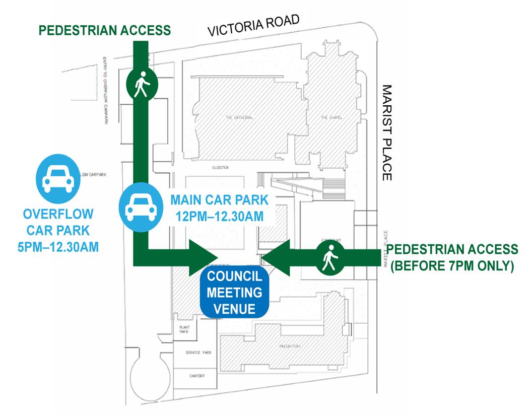
An Ordinary Meeting of City of Parramatta Council will be held in the Cloister Function Rooms, St Patrick's Cathedral, 1 Marist Place, Parramatta on Monday, 22 March 2021 at 6.30pm.
Brett Newman
CHIEF EXECUTIVE OFFICER
COUNCIL CHAMBERS
|
Governance Manager |
Lord Mayor |
Chief Executive Officer |
|
|||||||
|
|
||||||||||
|
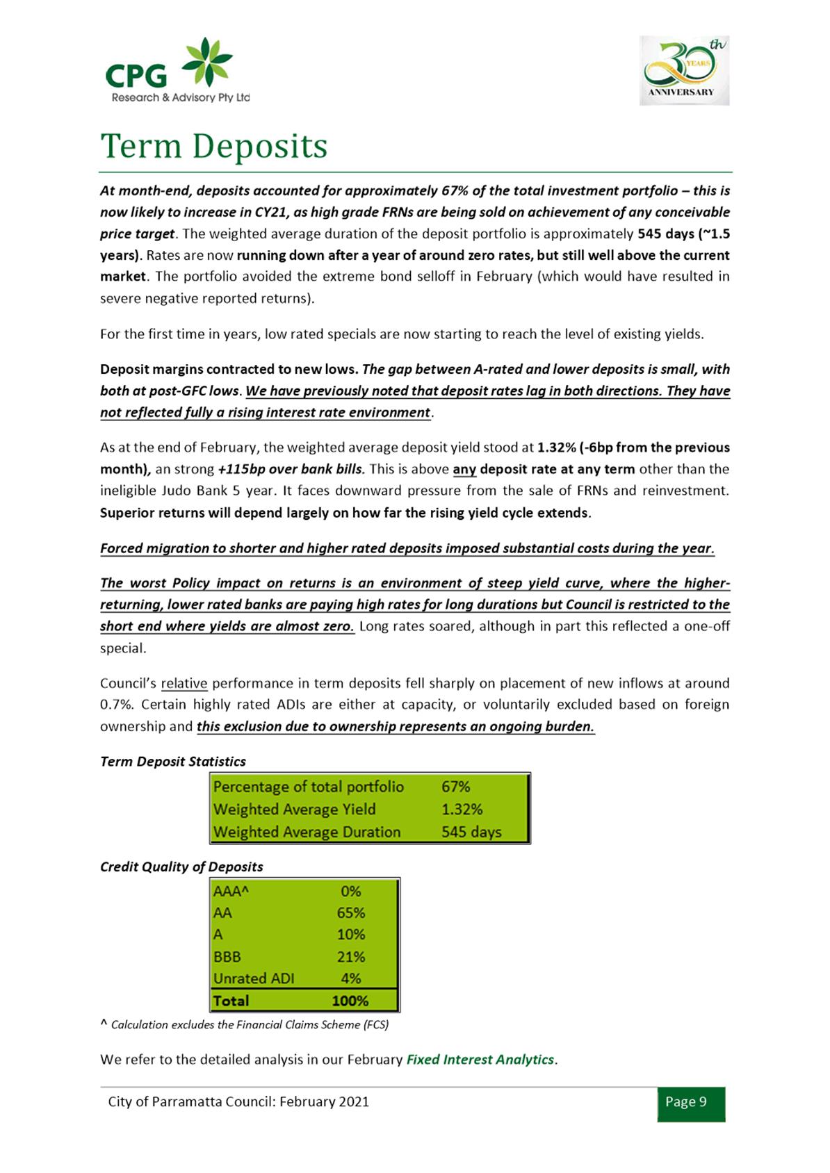
|
|
Minute Clerk |
|
|
|
|
||||
|
Clr Phil Bradley |
|
Clr Lorraine Wearne
|
|
Sound |
||||||
|
Clr Sameer Pandey |
Clr Andrew Wilson
|
|
|
|||||||
|
|
Clr Andrew Jefferies
|
|
|
|||||||
|
Clr Dr Patricia Prociv |
Clr Bill Tyrrell
|
|
IT |
|||||||
|
Clr Pierre Esber |
Clr Benjamin Barrak
|
|
|
|||||||
|
Clr Donna Davis |
Clr Martin Zaiter
|
|
|
|||||||
|
Clr Michelle Garrard, Deputy Lord Mayor |
Clr Steven Issa
|
|
|
|||||||
|
Executive Director City Engagement & Experience |
Executive Director Community Services |
Executive Director City Planning & Design |
Group Manager City Strategy |
Executive Director City Assets & Operations |
Executive Director Corporate Services |
Executive Director Property and Place |
|
|
|||||
|
|
Press |
Press |
|
|
|
|
|
|||||
|
Public Gallery |
|||||
THIS PAGE IS LEFT INTENTIONALLY BLANK
Council 22 March 2021
TABLE OF CONTENTS
ITEM SUBJECT PAGE NO
1 OPENING MEETING
2 ACKNOWLEDGMENT OF THE TRADITIONAL LAND OWNERS
3 WEBCASTING ANNOUNCEMENT
4 OTHER RECORDING OF MEETING ANOUNCEMENT
5 CONFIRMATION OF MINUTES
Council - 8 March 2021............................. 8
6 APOLOGIES AND APPLICATIONS FOR LEAVE OF ABSENCE
7 DECLARATIONS OF INTEREST
Nil
12.1 FOR NOTATION: Investment Report for February 2021....... 22
13.1 FOR APPROVAL: Response to NOM - Safety of Pedestrians and Food Delivery Bike Riders 60
14.1 FOR APPROVAL: Belmore Park Masterplan............................. 86
Nil
Nil
17.1 FOR APPROVAL: Submission to DPIE on draft Westmead Place Strategy............................... 178
17.2 FOR APPROVAL: Pre Gateway - Planning Proposal for 64 Victoria Road, North Parramatta........................... 335
17.3 FOR APPROVAL: Post Gateway - Proposed Amendment to the Wentworth Point Precinct DCP 2014 and Draft Planning Agreement for 14-16 Hill Road, Wentworth Point (Sekisui Planning Proposal) (Deferred Item).................................... 416
17.4 FOR APPROVAL: Post Gateway - Draft Development Control Plan and Letter of Offer (Planning Agreement) - 135 George St and 118 Harris St, Parramatta (Albion Hotel site)...................................... 619
17.5 FOR APPROVAL: Post Gateway - Amended Melrose Park North Planning Proposal and Draft Site-Specific Development Control Plan and Planning Agreement........................... 658
17.6 FOR APPROVAL: Post Exhibition - Planning Proposal, Development Control Plan and Planning Agreement - 197 and 207 Church St and 89 Marsden St, Parramatta...................... 872
17.7 FOR NOTATION: Minutes of the Smart City Advisory Committee Meeting held on 23 February 2021................................... 1017
18.1 NOTICE OF MOTION: $300+ Million at Risk from Council's Essential Community Infrastructure Program due to the NSW Government's New Infrastructure Contributions System............................... 1030
18.2 NOTICE OF MOTION: Interpretive Signs............... 1033
18.3 NOTICE OF MOTION: Report on Misuse of Mobility Parking Scheme.............................. 1035
Nil
20.1 FOR APPROVAL: Tender 53/2018 - Unified Booking System
This report is confidential in accordance with section 10A (2) (c) (d) of the Local Government Act 1993 as the report contains information that would, if disclosed, confer a commercial advantage on a person with whom the Council is conducting (or proposes to conduct) business; AND the report contains commercial information of a confidential nature that would, if disclosed (i) prejudice the commercial position of the person who supplied it; or (ii) confer a commercial advantage on a competitor of the Council; or (iii) reveal a trade secret.
20.2 FOR APPROVAL: Tender 04/2020 - Aquatic Leisure Centre Parramatta - Design and Construct Contract
This report is confidential in accordance with section 10A (2) (c) (d) of the Local Government Act 1993 as the report contains information that would, if disclosed, confer a commercial advantage on a person with whom the Council is conducting (or proposes to conduct) business; AND the report contains commercial information of a confidential nature that would, if disclosed (i) prejudice the commercial position of the person who supplied it; or (ii) confer a commercial advantage on a competitor of the Council; or (iii) reveal a trade secret.
20.3 QUESTION WITH NOTICE: Questions Taken on Notice from Council Meeting - 8 March 2021
This report is confidential in accordance with section 10A (2) (d) of the Local Government Act 1993 as the report contains commercial information of a confidential nature that would, if disclosed (i) prejudice the commercial position of the person who supplied it; or (ii) confer a commercial advantage on a competitor of the Council; or (iii) reveal a trade secret.
21 PUBLIC ANNOUNCEMENT OF RESOLUTIONS PASSED IN CLOSED SESSION
22 CONCLUSION OF MEETING
After the conclusion of the Council Meeting, and if time permits, Councillors will be provided an opportunity to ask questions of staff.
MINUTES OF THE Meeting of City of Parramatta Council HELD IN THE CLOISTER FUNCTION ROOMS, ST PATRICK’S CATHEDRAL 1 MARIST PLACE, PARRAMATTA ON Monday, 8 March 2021 AT 6.30pm
These are draft minutes and are subject to confirmation by Council at its next meeting. The confirmed minutes will replace this draft version on the website once confirmed.
PRESENT
The Lord Mayor, Councillor Bob Dwyer and Councillors Benjamin Barrak (6:43pm), Phil Bradley, Donna Davis, Pierre Esber, Michelle Garrard (Deputy Lord Mayor), Steven Issa, Andrew Jefferies (6:32pm), Sameer Pandey, Dr Patricia Prociv, Bill Tyrrell, Andrew Wilson, Lorraine Wearne and Martin Zaiter.
1. OPENING MEETING
The Lord Mayor, Councillor Bob Dwyer, opened the meeting at 6.30pm.
2. ACKNOWLEDGEMENT OF THE TRADITIONAL LAND OWNERS
The Lord Mayor, acknowledged the Burramattagal people of The Darug Nation as the traditional custodians of this land, and paid respect to their ancient culture and their elders past and present.
3. WEBCASTING ANNOUNCEMENT
The Lord Mayor, advised that this public meeting is being recorded and streamed live on the internet. The recording will also be archived and made available on Council’s website.
The Lord Mayor further advised that all care will be taken to maintain privacy, however as a visitor in the public gallery, the public should be aware that their presence may be recorded.
4. OTHER RECORDING OF MEETING ANOUNCEMENT
As per Council’s Code of Meeting Practice, the recording of the Council Meeting by the public using any device, audio or video, is only permitted with Council permission. Recording a Council Meeting without permission may result in the individual being expelled from the Meeting.
5. CONFIRMATION OF MINUTES
|
|
SUBJECT: Minutes of the Council Meeting held on 22 February 2021
|
|
3103 |
RESOLVED (Davis/Tyrrell)
That the minutes be taken as read and be accepted as a true record of the Meeting.
|
|
|
Note: Councillor Jefferies arrived at 6:32pm during Confirmation of Minutes. |
6. APOLOGIES/REQUESTS FOR LEAVE OF ABSENCE
There were no apologies/requests for leave of absence made at this meeting.
7. DECLARATIONS OF INTEREST
There were no Declarations of Interest made at this meeting.
8. Minutes of the Lord Mayor
|
8.1 |
SUBJECT Condolence Motion: Former Councillor Elaine Evans
REFERENCE F2019/03630 - D07938495
REPORT OF Lord Mayor, Councillor Bob Dwyer
|
|
3104 |
RESOLVED (Dwyer/Pandey)
(a) That Council acknowledge the passing of former Parramatta City Councillor Elaine Evans, offering our condolences to her family and friends.
(b) That Council write a letter of condolence to the family of Mrs Evans, acknowledging her passing and valued community services.
(c) That the Chamber hold a minute’s silence as a gesture of respect on her passing and in recognition of her dedication to the Parramatta and Western Sydney communities.
(d) Further, that Council write to the Parramatta Park Trust requesting that a tree be planted in memory of Mrs. Elaine Evans, for her contributions to the community. |
|
8.2 |
SUBJECT International Women's Day 2021
REFERENCE F2019/03630 - D07921814
REPORT OF Lord Mayor, Councillor Bob Dwyer
|
|
3105 |
RESOLVED (Dwyer/Issa)
(a) That Council note that today, 8 March, is International Women’s Day and this year’s global UN Women theme is “Women in Leadership: Achieving an equal future in a COVID-19 world”.
(b) That Council note that to celebrate International Women’s Day in 2021, City of Parramatta Council has highlighted the contributions of six women with deep connections to Parramatta in a print and social media campaign. These women are: · Aunty Julie Jones · Gillian Kayrooz · Sue Hardman · Maeve Brown · Christine Lam · Aunty Corina Wayali Norman.
(c) Further, that Council note the following Western Sydney women have been nominated in the NSW Women of the Year awards for their contributions, and wish them all the best for the awards ceremony on 10 March 2021: · Amanda Rose, Western Sydney Women – NSW Woman of Excellence nominee · Alison Covington, Good 360 Australia – NSW Woman of Excellence nominee · Chris Cleary, StreetMed Incorporated and StreetPet – Aware Super NSW Community Hero nominee.
|
|
|
Note: Councillor Barrak arrived at 6:43pm during consideration of Item 8.2. |
|
8.3 |
SUBJECT Phillip Lane Activation
REFERENCE F2019/03630 - D07921822
REPORT OF Lord Mayor, Councillor Bob Dwyer
|
|
3106 |
RESOLVED (Dwyer/Zaiter)
(a) That Council note the Phillip Lane Outdoor Dining Project, which expanded outdoor dining for adjacent restaurants in Phillip Lane in the Parramatta CBD on weekends (5pm – 10pm, Friday and Saturday nights), took place in the four weekends prior to Christmas 2020 and then again between 29 January and 20 February 2021.
(b) That Council thank businesses that participated and accommodated this project including but not limited to Lone Star Rib House and Brews, John Belvedere, Bondi Pizza, El-Phoenician and the ParkRoyal Hotel.
(c) Further, that Council staff prepare a report to Councillors that provides an evaluation of the initiative, including feedback from affected stakeholders and any proposed next steps associated with making permanent improvements to the laneway. |
9. Public Forum
There were no public forums for this meeting.
10. Petitions
There were no petitions tabled at this meeting.
11. Rescission Motions
There were no rescission motions for this meeting.
12. Fair
|
12.1 |
SUBJECT FOR APPROVAL: Rates Harmonisation Community Feedback and Recommendation (Deferred Item)
REFERENCE F2014/02600 - D07887521
REPORT OF Rates & Receivables Manager
|
|
|
MOTION (Tyrrell/Garrard)
(a) That Council approve the new proposed rates structure, which has been out for community consultation.
(b) That Council seek approval from the Minister for Local Government to increase the minimum ordinary rates for any rating category or subcategory that is above the statutory limit.
(c) That the new proposed rates structure is included as part of 2021/2022 Delivery Program and Operational Plan and Budget.
(d) That Council note that the former CBD Special Rate Levy was levied on business properties contained within the former Parramatta LGA CBD and is proposed to be incorporated across business rates in the City of Parramatta LGA CBD.
(e) Further, that Council establish from 1 July 2021 a new internally restricted reserve (the “CBD Infrastructure Internal Reserve” (“New Reserve”)) for the same purpose as the CBD Infrastructure Special Rate (“CISR”) and that: i) the New Reserve be increased each year by an amount equal to the CISR levy in 2020/21, adjusted by the IPART rate-peg for the relevant year and funded from general reserves; ii) consistent with the current CISR levy, the purpose of the New Reserve will be to provide resources for the improvements to CBD infrastructure that will attract additional business to the Parramatta CBD area, including street paving, security, street furniture, street lighting, and a CBD river foreshore enhancement; iii) all projects to be funded from the New Reserve be approved by Council as part of the annual budget process.
|
|
|
AMENDMENT (Bradley/Prociv)
(a) That Council approve the new proposed rates structure, which has been out for community consultation.
(b) That Council seek approval from the Minister for Local Government to increase the minimum ordinary rates for any rating category or subcategory that is above the statutory limit.
(c) That the new proposed rates structure is included as part of 2021/2022 Delivery Program and Operational Plan and Budget.
(d) That Council note that the former CBD Special Rate Levy was levied on business properties contained within the former Parramatta LGA CBD and is proposed to be incorporated across business rates in the City of Parramatta LGA CBD.
(e) That Council establish from 1 July 2021 a new internally restricted reserve (the “CBD Infrastructure Internal Reserve” (“New Reserve”)) for the same purpose as the CBD Infrastructure Special Rate (“CISR”) and that: i) the New Reserve be increased each year by an amount equal to the CISR levy in 2020/21, adjusted by the IPART rate-peg for the relevant year and funded from general reserves; ii) consistent with the current CISR levy, the purpose of the New Reserve will be to provide resources for the improvements to CBD infrastructure that will attract additional business to the Parramatta CBD area, including street paving, security, street furniture, street lighting, and a CBD river foreshore enhancement; iii) all projects to be funded from the New Reserve be approved by Council as part of the annual budget process.
(f) Further, that a report come back to Council on the establishment of an Open Space and Embellishment Internal Reserve.
The amendment moved by Councillor Bradley and seconded by Councillor Prociv on being put was declared LOST.
The motion moved by Councillor Tyrrell and seconded by Councillor Garrard on being put was declared CARRIED.
|
|
3107 |
RESOLVED (Tyrrell/Garrard)
(a) That Council approve the new proposed rates structure, which has been out for community consultation.
(b) That Council seek approval from the Minister for Local Government to increase the minimum ordinary rates for any rating category or subcategory that is above the statutory limit.
(c) That the new proposed rates structure is included as part of 2021/2022 Delivery Program and Operational Plan and Budget.
(d) That Council note that the former CBD Special Rate Levy was levied on business properties contained within the former Parramatta LGA CBD and is proposed to be incorporated across business rates in the City of Parramatta LGA CBD.
(e) Further, that Council establish from 1 July 2021 a new internally restricted reserve (the “CBD Infrastructure Internal Reserve” (“New Reserve”)) for the same purpose as the CBD Infrastructure Special Rate (“CISR”) and that: i) the New Reserve be increased each year by an amount equal to the CISR levy in 2020/21, adjusted by the IPART rate-peg for the relevant year and funded from general reserves; ii) consistent with the current CISR levy, the purpose of the New Reserve will be to provide resources for the improvements to CBD infrastructure that will attract additional business to the Parramatta CBD area, including street paving, security, street furniture, street lighting, and a CBD river foreshore enhancement; iii) all projects to be funded from the New Reserve be approved by Council as part of the annual budget process.
|
|
|
Note: Councillor Bradley and Councillor Wilson requested that their names be recorded as having voted against the decision taken in this matter. |
13. Accessible
|
13.1 |
SUBJECT FOR NOTATION: Variations to Standards under Clause 4.6 of Parramatta LEP 2011, Auburn LEP 2010, Holroyd LEP 2013, The Hills LEP 2012, Hornsby LEP 2013 and SEPP 1
REFERENCE F2009/00431 - D07851173
REPORT OF Group Manager - Development and Traffic Services
|
|
3108 |
RESOLVED (Esber/Garrard)
That the report be received and noted. |
14. Green
Nil
15. Welcoming
Nil
16. Thriving
Nil
17. Innovative
Nil
18. Notices of Motion
|
18.1 |
SUBJECT NOTICE OF MOTION: Waterfront Kayak Club
REFERENCE F2021/00521 - D07910793
FROM Councillor Issa
|
|
3109 |
RESOLVED (Issa/Tyrrell)
(a) That Council works to explore, and present options back to Council to support the Waterfront Kayak Club in the storage of their equipment.
(b) That the options include short term (to be defined in the report) possibilities, as well as longer term that could be incorporated into Peninsula Park.
(c) Further, that Council officers work with all relevant stakeholders in developing these options. |
19. Questions with Notice
|
19.1 |
SUBJECT QUESTION WITH NOTICE: Environmental Planning and Assessment (Local Infrastructure Contributions – Timing of Payments) Direction 2020
REFERENCE F2021/00521 - D07914648
FROM Councillor Davis
|
|
|
QUESTION
Under the Environmental Planning and Assessment (Local Infrastructure Contributions – Timing of Payments) Direction 2020 (Direction), Minister Stokes made a Direction that shifted the payment of Section 7.11 contributions at the time of issuance of a building certificate, to the time of issuance of an occupational certificate.
1. How has this impacted on City of Parramatta’s projected incoming Section7.11 revenue?
2. Which Section 7.11 / capital works projects, if any, will be impacted by this change and how?
3. Has the Council made any representations to the Minister, local State Members of Parliament or relevant departmental officers regarding this direction?
4. Is Council aware of any intention, by the Minister, to extend the period of the direction?
ANSWER
How has this impacted on City of Parramatta’s projected incoming Section7.11 revenue?
5. The Minister’s Decision will not impact on the quantum of contributions to be paid to Council. The obligation for the developer to pay Council remains as a condition on the approval. The Direction simply means that Council will receive the payment closer to the end of the construction process rather than at the commencement of the construction process which is the traditional time of payment.
6. An additional potential major impact on Council would be an increase in the risk and administrative costs if a developer goes into receivership between commencing and finalising the work. In this case Council would still be legally entitled to payment but there would increased administrative cost in obtaining the payment and increased risk that Council may not collect the full amount.
Which Section 7.11 / capital works projects, if any, will be impacted by this change and how?
7. The impact on capital works projects will be a potential delay in the delivery of Council projects. Which projects will be impacted will depend on decisions Council makes in the future on which projects to prioritise based on existing funds available. These impacts will be analysed and be considered during the ongoing review of Council’s budget.
Has the Council made any representations to the Minister, local State Members of Parliament or relevant departmental officers regarding this direction?
8. The views of Council staff have recently been sought by Department of Planning, Industry and Environment officers on this measure which Department staff advise will be considered as part of a broader review into infrastructure contributions in response to a report by the NSW Productivity Commission. Staff have advised that if the Order is continued it will have the potential to significantly impact on the staging of the receipt of revenue from contributions from major developments that would be used to help provide facilities for our existing and growing population and is therefore likely to be opposed by Council.
Is Council aware of any intention, by the Minister, to extend the period of the direction?
9. Department of Planning, Industry and Environment officers have confirmed that the changes to the regulations that enable payment to be made closer to the end of the construction phase expire at the end of March 2021. A NSW Productivity Commission report has been provided to the Government recommending that the new arrangements be made permanent and the Department and Minister are considering the Productivity Commission recommendation and expect to make an announcement in the near future on its response to the Productivity Commission recommendation.
|
|
|
Note: Councillor Garrard left the Chamber at 7:33pm and returned at 7:36pm during consideration of Item 19.1. |
20. CLOSED SESSION
Note: Prior to moving into Closed Session, the Lord Mayor invited members of the public gallery to make representations as to why any item had been included in Closed Session. No member of the gallery wished to make representations.
|
3110 |
RESOLVED (Tyrrell/Esber)
That members of the press and public be excluded from the meeting of the Closed Session and access to the correspondence and reports relating to the items considered during the course of the Closed Session be withheld. This action is taken in accordance with Section 10A(s) of the Local Government Act, 1993 as the items listed come within the following provisions:- 1 FOR NOTATION: Legal Status Report as at 27 January 2021. (D07885614) - This report is confidential in accordance with section 10A (2) (g) of the Local Government Act 1993 as the report contains advice concerning litigation, or advice that would otherwise be privileged from production in legal proceedings on the ground of legal professional privilege. 2 FOR APPROVAL: Sale of land under Section 713 of the Local Government Act. (D07766697) - This report is confidential in accordance with section 10A (2) (a) (e) of the Local Government Act 1993 as the report contains personnel matters concerning particular individuals; AND the report contains information that would, if disclosed, prejudice the maintenance of law. 3 FOR APPROVAL: Strategic Partnerships (Educate AT Parramatta and Parramatta Square). (D07894638) - This report is confidential in accordance with section 10A (2) (d) of the Local Government Act 1993 as the report contains commercial information of a confidential nature that would, if disclosed (i) prejudice the commercial position of the person who supplied it; or (ii) confer a commercial advantage on a competitor of the Council; or (iii) reveal a trade secret. 4 Parramatta Light Rail - Outdoor Dining. (D07934933) - This report is confidential in accordance with section 10A (2) (g) of the Local Government Act 1993 as the report contains advice concerning litigation, or advice that would otherwise be privileged from production in legal proceedings on the ground of legal professional privilege. |
|
20.1 |
SUBJECT FOR NOTATION: Legal Status Report as at 27 January 2021
REFERENCE F2020/03849 - D07885614
REPORT OF Group Manager Legal Services
|
|
3111 |
RESOLVED (Tyrrell/Wilson)
That Council note the Legal Status Report as at 27 January 2021. |
|
20.2 |
SUBJECT FOR APPROVAL: Sale of land under Section 713 of the Local Government Act
REFERENCE F2017/03463 - D07766697
REPORT OF Group Manager Regulatory Services
|
|
|
MOTION (Tyrrell/Garrard)
(a) That Council approve the sale of (Lot 1 DP. 8641), 105 Victoria Road, Parramatta, to recover the outstanding accrual of rates and charges.
(b) That Council notes the continued impact of this abandoned property relative to the continued overgrown and dilapidated state of the property affecting the amenity of neighbours and surrounding community.
(c) Further, that Council note the continued impact on council’s resources for over ten (10) years in attending the abandoned property to make safe.
|
|
|
AMENDMENT (Bradley/)
(a) That Council approve the forced sale of (Lot 1 DP. 8641), 105 Victoria Road, Parramatta, to recover the outstanding accrual of rates and charges.
(b) That Council notes the continued impact of this abandoned property relative to the continued overgrown and dilapidated state of the property affecting the amenity of neighbours and surrounding community.
(c) Further, that Council note the continued impact on council’s resources for over ten (10) years in attending the abandoned property to make safe.
The amendment moved by Councillor Bradley lapsed without a seconder.
|
|
|
AMENDMENT (Barrak/Esber)
That consideration of this matter be deferred for four weeks pending further attempts to locate the owners, with a view to seeking to resolve the issue amicably and without the need for a forced sale.
|
|
3112 |
RESOLVED (Issa/Tyrrell)
That the motion be put.
|
|
|
The amendment moved by Councillor Barrak and seconded by Councillor Esber on being put was declared LOST.
The motion moved by Councillor Tyrrell and seconded by Councillor Garrard on being put was declared CARRIED.
|
|
3113 |
RESOLVED (Tyrrell/Garrard)
(a) That Council approve the sale of (Lot 1 DP. 8641), 105 Victoria Road, Parramatta, to recover the outstanding accrual of rates and charges.
(b) That Council notes the continued impact of this abandoned property relative to the continued overgrown and dilapidated state of the property affecting the amenity of neighbours and surrounding community.
(c) Further, that Council note the continued impact on council’s resources for over ten (10) years in attending the abandoned property to make safe.
|
|
|
Note: 1. Councillor Davis retired from the meeting at 7:52pm during consideration of Item 20.2 and did not return. 2. Councillor Barrak requested that his name be recorded as having voted against the decision taken in this matter. |
|
20.3 |
SUBJECT FOR APPROVAL: Strategic Partnerships (Educate AT Parramatta and Parramatta Square)
REFERENCE F2021/00247 - D07894638
REPORT OF Group Manager City Strategy
|
|
3114 |
RESOLVED (Issa/Garrard)
(a) That Council note the progress on the development of the Alliance Program set out in this report and endorse the Lord Mayor signing non-binding Charters for the two Alliances in this report.
(b) Further, that Council note the proposed signing of the Charters at media events for the respective Alliances. |
|
20.4 |
SUBJECT Parramatta Light Rail - Outdoor Dining
REFERENCE F2019/03630 - D07934933
REPORT OF Lord Mayor, Councillor Bob Dwyer
|
|
3115 |
RESOLVED (Dwyer/Tyrrell)
That Council resolve in accordance with the confidential Lord Mayoral Minute tabled at the Council Meeting of 8 March 2021. |
|
|
Procedural Motion
|
|
3116 |
RESOLVED (Tyrrell/Esber)
That the meeting resume into Open Session. |
21. REPORTS OF RESOLUTIONS PASSED IN CLOSED SESSION
The Chief Executive Officer read out the resolutions for Items 20.1 to 20.4.
22. CONCLUSION OF MEETING
The meeting terminated at 8:14pm.
THIS PAGE AND THE PRECEDING 11 PAGES ARE THE MINUTES OF THE ORDINARY COUNCIL MEETING HELD ON MONDAY, 8 MARCH 2021 AND CONFIRMED ON MONDAY, 22 MARCH 2021.
Chairperson
Fair
22 March 2021
12.1 FOR NOTATION: Investment Report for February 2021.................................... 22
Council 22 March 2021 Item 12.1
ITEM NUMBER 12.1
SUBJECT FOR NOTATION: Investment Report for February 2021
REFERENCE F2009/00971 - D07936139
REPORT OF Tax and Treasury Accountant
|
PURPOSE:
The purpose of this report is to inform Council of the investment portfolio performance and compliance for the month of February 2021.
|
|
That Council receive the Investment Report for February 2021.
|
BACKGROUND
1. In accordance with clause 212 of the Local Government (General) Regulation 2005 (the Regulation), a report setting out details of all money invested must be presented to Council on a monthly basis.
2. The report must include a certificate as to whether or not the investments have been made in accordance with the Local Government Act 1993 (the Act), the Regulation and Council’s Investment Policy.
ISSUES/OPTIONS/CONSEQUENCES
Investment Portfolio Summary
3. The investment portfolio closing balance as at
28 February 2021 was $532.2m. The average portfolio holdings held throughout
the month was $526m.
4. The majority of Council’s investment
portfolio is in term deposits (67%). The portfolio also includes liquid
Floating Rate Notes (FRNs), cash, and the TCorp Long Term Growth Fund (LTGF).
5. Approximately
8% of the portfolio are less conservative long-term investments. The investment
portfolio is well diversified and weighted towards higher-rated institutions.
6. The table
below lists the diversified range of investments held by Council as at 28
February 2021:
Table 1: Summary of investment portfolio

Performance Summary
7. Investment performance for the month. The
investment portfolio reported an annualised return of 1.67% in February,
outperforming the AusBond Bank Bill Index benchmark of -0.01%. The Colonial
First State (CFS) Managed Fund (0.49% return for the month) and FRNs (0.21%
return for the month) were the main contributors towards the performance this
month.
8. Historical investment performance. The
table below provides year-to-date and historical investment performance
compared to the Ausbond Bank Bill Index.
Table 2: Historical investment portfolio performance

9. Investment income. As at 28 February 2021, year-to-date investment income was $8.3m, approximately $930k above budget. The outperformance is primarily due to the TCorp LTGF (14.09% return year-to-date), and the CFS Global Managed Fund (6.73% return year-to-date). Council’s portfolio is also weighted towards term deposits and FRNs yielding above 1.50%.
Table 3: Year-to-date cumulative interest income

Performance by Investment Type
Floating rate notes (FRNs)
10. Council’s senior FRNs made up around 15% of the total investment portfolio at month-end. The market value of Councils FRNs collectively fell by approximately -0.09%. During the month Council sold $6.5m in FRNs which resulted in a realized capital gain of $94k.
Table 4: Floating rate note investments (A- to AAA rated)

11. Council’s
A- to AAA-rated FRNs are senior (high) ranked assets in the bank capital
structure. It is expected that, if held to maturity, the FRNs will pay back
their original face value, along with its quarterly coupons, throughout the
life of the FRN.
12. Council’s
advisors do not anticipate Council to lose any capital or interest payments
from its current holding of these senior FRNs as all banks continue to maintain
high capital buffers as required by the Australian Prudential Rating Agency
(APRA).
13. They also have no concerns with Council’s investments in BBB-rated senior FRNs given all counterparties continue to maintain robust balance sheets with high levels of capital. Council sold approximately $1m in BBB FRNs during the month resulting in a realised capital gain of approximately $8k.
14. The market valuation of Council’s remaining BBB-rated FRNs decreased by $12k, or -0.03%, on a mark-to-market basis (total unrealised capital gain of $232k).
Table 5: Floating rate note investments (BBB rated)

Northern Territory Treasury Corporation Senior Bonds (NTTC bonds)
15. NTTC bonds comprise 2.0% ($11m) of Council’s investment portfolio and are yielding between 0.90% and 1.00% for two- to five-year terms. NTTC bonds are a ‘retail’ offering and not ‘wholesale’ issuances. Given the lack of liquidity and high penalty costs if they were to be sold/redeemed prior to the maturity date, they are considered to be a hold-to-maturity investment and will be marked at face value throughout the term of the investment.
Term Deposits
16. Term
Deposits account for around 67% of the total investment portfolio at month-end.
Council’s term deposit portfolio was yielding 1.32% p.a. at month-end,
with a weighted-average duration of around 545 days, or 1.5 years. The longer
average duration will provide some income protection against the low interest
rate environment for the next twelve months. However, as existing deposits
mature, they will inevitably be reinvested at much lower prevailing rates.
17. Given interest rates have fallen to all-time lows, Council is likely to see a rapid decline in interest income over the next few financial years, with reinvestment offers likely to range between 0.40% and 0.70%.
TCorp Long Term Growth Fund
18. The TCorp Long Term Growth Fund accounts for around 5% of Council’s total investment portfolio. The Fund returned 0.17% for the month, or 2.21% annualised. Both Domestic and international shares rose, offsetting losses from fixed bonds.
Table 6: TCorp Long Term Growth Fund

19. According
to Council’s advisors, it is anticipated that there will be a sustained
level of volatility in equity markets, particularly as downside risks to global
growth remain. Unemployment globally has risen considerably over recent months,
with the collective economic impact likely to be more severe than the global
financial crisis (GFC).
20. This
Fund has a long-term view (7+ years). Given the exposure to volatile equity
markets, Council should expect in some months to report negative returns, but
over the long-term, it is expected to outperform term deposits and FRNs.
CFS Global Credit Managed Fund
21. This
fund accounts for around 2.5% of Council’s total investment portfolio.
The Fund returned 0.44% (5.92% annualised) in February, as the market valuation
of the fund’s assets in global credit securities (FRNs and bonds) rose.
Table 7: CFS Global Credit Managed Fund

22. The Fund holds a diverse range of securities across the global credit market. It remains very well diversified by issuer in order to mitigate default risk. It invests in nearly 600 corporate bonds from issuers in various countries and industry sectors. This grandfathered fund has a current running yield of 1.5%.
Cash-at-call
23. Cash-at-call makes up approximately 9.5% of the investment portfolio. Council has negotiated a special rate with National Australia Bank (cash rate plus 45 basis points, currently 0.55%). This rate is higher than most market TDs of one to twelve months.
Maturities
24. Council has a
substantial investment allocation to securities and bonds, as well as the CFS Global
Credit Managed Fund. The portfolio is well spread across maturities, utilising
capacity available in short- to medium-term maturities.
25. The maturity profile as at 28 February 2021. The maturity profile table below illustrates that the maturity duration is well-spread with approximately 15% available in working capital, 25% maturing within twelve months, 16% in one to two years, 37% in two to five years, and a further 6% in greater than five years, maximising council’s returns in longer term rates.
Graph 1: Maturity profile

Compliance
26. The portfolio complies with Council’s Investment Policy rating limits, with ample investment opportunity still available in A-rated institutions, and approx. $20m capacity in BBB+/unrated institutions.
Graph 2: Investment Policy rating capacity

*BBB+/BBB limits combined under Council’s investment policy.
27. Counterparty Limits. All individual counterparty limits comply with council’s investment policy, with the following exceptions:
Table 8: Exceptions to counterparty limits
|
Institution
|
Policy Limit (‘000) |
Held |
Overweight |
Reason |
Compliance Date |
|
Bank of QLD |
53.219 |
55,151 |
1,932 |
Portfolio shrinkage has caused counterparty to exceed 5%, however majority of funds placed prior to current investment policy and are considered "Grandfathered" |
29 April 2021
|
|
AMP 31 Day Cash Notice |
26,609 |
41,097 |
14,488 |
AMP Cash 31 Day Notice account was downgraded from BBB+ to BBB late last year, changing the policy limit from 10% to 5%. The investment policy requires Council to divest when practical, taking into consideration the financial impact of breaking investments. |
31 days’ notice has been given to divest, with funds to be redeemed on 1 March 2021 |
28. Council engages CPG Research & Advisory (CPG) and Imperium Markets for assistance in all investment matters relating to advice, risk and portfolio weighting. CPG monitor the portfolio daily and conduct a monthly health check review. This confirms that Council’s portfolio is conducted in accordance with the Act, the Regulation and the Investment Policy.
Certification of Investments
29. I
hereby certify that the investments for the month of February 2021 have been
made in accordance with the Act, the Regulations and Council’s Investment
Policy:
Paul Perrett, Chief Financial Officer.
CONSULTATION & TIMING
Stakeholder Consultation
30. The following stakeholder consultation has been undertaken in relation to this matter:
|
Date |
Stakeholder |
Stakeholder Comment |
Council Officer Response |
Responsibility |
|
28 Feb 2021
|
CPG Research & Advisory
Imperium Markets |
All Investments are within Policy guidelines and supported by Councils independent advisor.
Refer CPG comprehensive Report |
Noting the counterparty overweight position listed in this report, All remaining Investments are within Policy limits and reconcile to the General Ledger as at 28 Feb 21 |
Finance Team Paul Perrett CFO
Bruce MacFarlane Treasury & Tax Accountant |
Councillor Consultation
31. The following Councillor consultation has been undertaken in relation to this matter:
|
Date |
Councillor |
Councillor Comment |
Council Officer Response |
Responsibility |
|
N/A |
N/A |
N/A |
N/A |
N/A |
FINANCIAL IMPLICATION FOR COUNCIL
32. Council’s interest income as at 28 February 2021 exceeds the year-to-date budget forecast by approximately $930k.
Bruce MacFarlane
Tax and Treasury Accountant
Paul Perrett
Chief Financial Officer
Michael Tzimoulas
Executive Director Corporate Services
Brett Newman
Chief Executive Officer
|
1⇩ |
Investment and Loans Performance Graph February 2021 |
1 Page |
|
|
2⇩ |
CPG Comprehensive Investment Report - February 2021 |
19 Pages |
|
|
3⇩ |
List of Council Investments by maturity February 2021 |
9 Pages |
|
Accessible
22 March 2021
13.1 FOR APPROVAL: Response to NOM - Safety of Pedestrians and Food Delivery Bike Riders......................................... 60
Council 22 March 2021 Item 13.1
ITEM NUMBER 13.1
SUBJECT FOR APPROVAL: Response to NOM - Safety of Pedestrians and Food Delivery Bike Riders
REFERENCE F2021/00077 - D07838433
REPORT OF Road Safety Officer
PURPOSE:
To respond to Council’s Notice of Motion on 9 November 2020 requesting a report be provided on the Safety of Pedestrians and Food Delivery Bike Riders.
That Council:
1. Note that the preliminary draft guidelines for the ‘Food Delivery Rider Safety’ report have been released from the NSW Taskforce led by SafeWork NSW and Transport for NSW.
2. Note that staff will review the NSW Taskforce ‘Food Delivery Rider Safety’ final report due in April 2021 and Centre for Work Health and Safety’s ‘Work Health and Safety of Food Delivery Workers in the Gig Economy’ final report due in October 2021 and report back to Council on potential actions that Council could take to respond to the reports via the Traffic Engineering Advisory Group.
3. Note the Council programs outlined within this report that have been implemented and trialled by Council to date.
4. Promote any future programs focussing on the safety for adult cyclists to Food Delivery Riders too.
5. Invite a Food Delivery Riders representative on to the Cycleways Advisory Committee.
6. Note that staff will continue to identify and address issues raised related to cyclist and pedestrian safety.
BACKGROUND
1. On 9 November 2020, Council considered a Notice of Motion regarding the safety of Food Delivery Riders and Pedestrians and resolved:
(a) That Council note:
(i) Community concerns related to the safety of delivery riders and pedestrians within the City of Parramatta.
(ii) Council note the risks from traffic, accidents and fatalities related to food delivery bike riders in Sydney in recent times.
(iii) Increase in food delivery bike riders due to COVID-19.
(iv) Concerns raised by residents for delivery riders use of footpaths. The riding of bicycles on the footpath poses a safety hazard to pedestrians, particularly those with limited mobility, the visually impaired and parents with prams.
(b) Further, that a report be provided on:
(i) Safety and Community awareness measures that council may implement to improve the safety of pedestrians and delivery riders.
(ii) Current relevant programs to improve awareness and safety.
(iii) Role of council in enforcing NSW Road Rule 250 in collaboration with LAC.
(iv) Educational and signage programs on safe riding to be conducted with providers of food delivery rider platforms such as Menulog, UberEats, Deliveroo, Dominos and other major providers.
(v) Means of direct engagement with riders, given the fact that food delivery platforms have not been proactive and have not shown interest in rider and community safety.
2. Four fatalities involving Food Delivery Riders (FDRs) occurred on Sydney roads in late 2020. Since the Council resolution initiating this report, the NSW Government has set up a ‘Food Delivery Rider Safety’ Taskforce to examine whether any avoidable risks may have contributed to the deaths of the food delivery riders. The investigation (led by SafeWork and Transport NSW), is expected to advise on safety improvements that could be made in this industry. The preliminary draft guidelines have been released from the NSW Taskforce (refer to reference SafeWork NSW and Transport for NSW Taskforce draft guidelines). The evaluation and findings report are scheduled to be completed in April 2021 (refer to reference SafeWork NSW and Transport for NSW Taskforce ‘Food Delivery Rider Safety’).
3. Furthermore, since February 2020, the NSW Government’s Centre for Work Health and Safety, in partnership with The Behavioural Insights Team (a policy consultant) and Macquarie University has undertaken research into food delivery in the gig economy. There are four phases to this research. Phase 1 explores the work health and safety perceptions of Food Delivery Workers (FDWs) while phase 2 researches the work health and safety perceptions of Food Delivery Platforms (FDPs). Phase 1 and 2 are now completed. It is intended that phases 3 and 4 will use the information gathered and engage key stakeholders within the industry to design and examine possible interventions to aid the work health and safety of those within the gig economy. The project is due for completion in October 2021 (refer to reference NSW Government Centre for Work Health and Safety, The Behavioural Insights Team, Macquarie University, Nov 2020).
4. Centre for Work Health and Safety’s report ‘Work Health and Safety Perceptions of Food Delivery Platforms in the Gig Economy’ notes that app-based food delivery accounts for 5.6% ($2.6b) of the restaurant trade in Australia and is growing at 86% per year without impacting income that restaurants would otherwise have made without app-based delivery (refer to reference AlphaBeta, February 2020, ‘Growing the Pie’ report).
5. The Covid-19 pandemic saw an increase in unemployment which in turn resulted in an increased supply of workers becoming FDRs. FDRs are generally paid per delivery. This may result in FDRs carrying out risky behavior (such as speeding or illegal cycling movements) in an effort to increase their volume of jobs. The Centre for WHS’s ‘Work Health and Safety Perceptions of Food Delivery Workers in the Gig Economy’ found that food delivery workers tend to be under 30 years old, male, and in Australia on student visas (the five most commonly reported countries of birth were India, Malaysia, Colombia, China and Indonesia). Furthermore, businesses which are serviced by food delivery riders are often located in high pedestrian activity areas resulting in a high interaction between food delivery riders and pedestrians.
6. It is recommended that Council note the preliminary draft guidelines released and that staff review the findings of the NSW Taskforce ‘Food Delivery Rider Safety’ report due in April 2021 and the findings of Centre for Work Health and Safety’s ‘Work health and safety of Food Delivery Workers in the Gig Economy’ report due in October 2021 and report back to Council on potential actions that Council could take to respond to the reports via the Traffic Engineering Advisory Group.
ISSUES/OPTIONS/CONSEQUENCES
7. The responses to each part of Council’s resolution from 9 November 2020 are provided below.
(i) Safety and Community awareness measures that council may implement to improve the safety of pedestrians and delivery riders.
a. Council currently undertakes safety and community awareness measures as detailed in item (ii). The discussion in item (i) relates to possible additional measures that could relate to FDRs.
b. Based on information gathered in Council programs and the findings of the Work Health and Safety draft guidelines, many FDRs are unfamiliar with NSW road rules and/or NSW bike rules and this has been identified as a hazard. The NSW Taskforce provides details of what FDPs and FDRs should be doing to improve safety. The TNSW Taskforce does not indicate that there is any role for Councils in the training of FDRs. The safety awareness and behaviour of FDRs is primarily considered as a work health safety matter.
c. However, Councils and TfNSW have a role in road safety awareness for the public which also benefits FDRs. It is recommended that future programs focussing on safety or encouragement of cycling, such as bike week activities that are promoted to adult cyclists, are also promoted to FDRs. It is also recommended that Council invite a representative of Food Delivery Riders onto the Cycleways Advisory Committee.
(ii) Current relevant programs to improve awareness and safety.
Shared Path Behaviour Education Program
a. Shared paths are designated for the use of both bicycle riders and pedestrians. They provide valuable access where it is undesirable or unsafe to ride on the road. There are several shared paths in the CBD, generally in areas with low pedestrian volumes. Since May 2020, Council has installed temporary behavioral reminder signs on shared paths. There are currently twenty corflute signs with messaging of ‘Share and Take Care’, ‘Slow Down’, and ‘Ring Your Bell’ (refer to attachment 1). The ‘Ring Your Bell’ message encourages cyclists to courteously inform pedestrians that they are approaching. Signs are relocated every three months with shared path locations chosen based on feedback received from customers, incident reports and where higher cyclist and pedestrian volumes occur. Council has received positive feedback from members of the public, noting behavioural improvements of both riders and walkers within the vicinity of the signs including requests for more signs to be installed. The ‘Share and Take Care’ messaging has also been used on City of Parramatta drink bottles which are given away at path activations, Bike Week events and Australia Day activities.
b. This program also targets users of specific paths to improve etiquette and safety in a similar manner to the Delivery Rider Engagement Program (see part (v) below) except the shared path program engages with any fast moving cyclists (including FDRs) and pedestrians displaying unsafe behavior.
Walk Your Bike Advisory Signs
c. In July 2020, Council installed aluminium ‘Walk Your Bike’ advisory signs after receiving reports of FDRs riding on the footpath on the north side of Victoria Road outside Coles Entrada, North Parramatta. Police were notified of the reports. Furthermore, in consultation with Council, the Parramatta Light Rail contractor installed ‘Walk Your Bike’ signage in July 2020 on its Church Street hoardings (refer to attachment 1). Opportunities to install TfNSW road safety messaging on hoardings are also being considered. Note that it remains legal for children aged 16 and under and their carers to ride on these footpaths, therefore the signs are only advisory.
Bike Rack Installation
d. Delivery riders often congregate whilst waiting for a job which can lead to a large number of bicycles and riders in one area. Council is investigating locations to install suitable bike racks from within existing budgets. This will support FDRs and safe pedestrian passage. Wheelchair/motorised scooter access, sightlines, and ongoing PLR works need to be considered during location selection. However to reduce delivery time, some FDRs choose not to lock up their bikes and instead take their bikes into food outlets when picking up an order.
Bicycle Servicing Assistance Program for Bicycle Delivery Riders
e. With an increased number of bicycle delivery riders servicing customers and businesses within the LGA, the ‘roadworthiness’ of bicycles being used by delivery riders was identified as a safety concern. Due to the increased demand, bicycles were covering greater distances resulting in more ‘wear and tear’ on bicycles. Furthermore, it was recognised that delivery riders can share the use of one bike whilst working in shifts. It is acknowledged that bike maintenance can be seen as a low priority to the rider as being ‘off road’ while servicing occurs, results in a loss of income. This is a safety issue and concern for all road users, including pedestrians.
f. In April 2020, as a result of this identified risk, Council initiated a trial program to raise awareness of this issue and actively encourage delivery riders to service their bicycles. After seeking expressions of interest, Council engaged the services of a local bicycle repairer (based in the Parramatta CBD) to participate in Council’s ‘Bicycle Servicing Assistance for Bicycle Delivery Riders’ program. The program provided eligible riders with a $50.00 voucher to be redeemed towards the servicing of their bicycle. As a further incentive, the rider was also offered the use of a free loan bicycle from the repairer while their bicycle was serviced. Participants in the scheme completed a Council survey which provided Council with information on FDR’s road safety awareness and knowledge.
g. Over 20 applications were received however only 9 vouchers were issued as the remaining applicants lived outside of the Parramatta LGA. No vouchers were redeemed. The service provider was contacted by 3 voucher recipients who wanted to use the voucher to replace parts on their bike, not for maintenance. Council received positive feedback on the program initiative from Uber Eats. Greater numbers would have been achieved if bicycle parts were provided, rather than servicing, and riders living outside the Parramatta area could participate (refer to attachment 2 for further program information including flyer and voucher).
(iii) Role of Council in enforcing NSW Road Rule 250 in collaboration with LAC.
a. By law, Council Rangers are unable to issue fines to riders who ride on the footpath (NSW Road Rule 250). These fines can only be issued by the Police. Any change in the law to allow Council Rangers to issue fines would result in resource ramifications and additional cost to Council. The work health and safety of Council Officers in performing this duty would also need to be considered.
b. Council’s Ranger and Parking Services Manager contacted the Crime Prevention Officer (CPO) at Parramatta Police Area Command and the CPO at Auburn Police (Homebush area) reporting the complaints received regarding FDRs. Parramatta Area Command utilized their foot and bike patrol to actively target offenders (focusing on the CBD).
c. Feedback received from the Parramatta CPO noted that while fines have been issued, they have been minimal as fines can only be issued when Police directly witness an illegal rider. Most riders appear to be overseas students/workers (non-permanent residents) and fines do not appear to be an effective deterrent. The decision to either provide a warning or a fine is made on a case by case basis at the discretion of the Police Officer. Various factors are taken into account including time of day, pedestrian traffic, speed of the rider, danger to the public, prior warnings and whether a complaint was made by a member of the public and any other factors deemed relevant by the Officer. Furthermore, Council Rangers and Parking Services collaborated with Council’s City Safe Team to conduct a week long street count using CCTV footage to establish rider behaviour (such as riding on footpaths, time, number of riders and locations). This information was then provided to the Police to assist with patrols.
d. Other regulatory measures conducted by Rangers and Parking Services have included written correspondence to the 3 major delivery services (Deliveroo, Menu Log and Uber Eats) advising of the increase in complaints and requesting that they instruct their riders to use the road and not the footpath as per Section 250 of the Road Rules 2014.
(iv) Educational and signage programs on safe riding to be conducted with providers of food delivery rider platforms such as Menulog, UberEats, Deliveroo, Dominos and other major providers.
a. Onboard training is the process a food delivery worker does when signing up to deliver for a platform. Each platform can decide what work health and safety information is provided to FDRs and in what context and delivery. Some platforms offer little on WHS policies and practices while others provide links, articles, education videos and quizzes to FDRs during their onboarding process. The Centre for Work Health Safety project stated that ‘while the majority of FDWs cared about safety, and believed that WHS was their responsibility, many demonstrated a lack of understanding and skills implementing standard safety information and practice’.
b. The NSW Taskforce advises that when onboarding FDRs, the FDP should consider their suitability, knowledge, and competence to provide safe and reliable food delivery services (note that this information from the Taskforce includes motorcycle or scooter riders). It requires that the FDP should:
· Ensure FPRs are trained and competent to do the work and can:
- demonstrate an understanding of NSW road rules
- demonstrate an understanding of NSW bike rules
· Ensure that FDRs hold the necessary credentials to undertake the work:
- visa to work
- NSW Rider Licence – if the FDR has resided in NSW for over 3 months
· Ensure that FDRs have the skills and confidence to ride safely on NSW roads
- riding skills
- knowledge of specific hazards of the job
· Ensure that FDRs retain the necessary skills and competencies to work safely.
- annual refresher training
· Amend training requirements and competencies when new hazards are notified.
c. On 28 February 2021, the Sydney Morning Herald reported that as of 2 March 2021, Uber Eats will be commencing a new object recognition feature in its app to detect whether its riders are wearing a helmet. The rider will also be required to complete a checklist of their bike’s roadworthiness. Uber Eats will also begin distributing lights, reflective vests, bells and phone holders (however not helmets) to their riders during March 2021. The new helmet detection software and checklist are being implemented in Australia before anywhere else. Some other companies, including Deliveroo, already provide their riders with some safety items such as jackets.
(v) Means of direct engagement with riders, given the fact that food delivery platforms have not been proactive and have not shown interest in rider and community safety.
Delivery Rider Engagement Program
a. In August 2020 Council engaged Addventageous (a social enterprise bike education and training organisation) to monitor and engage with riders within the Parramatta CBD. This involved talking directly to riders regarding the road rules and their responsibilities. Approximately 90 riders across 6 days were engaged during this program (refer to attachment 3 for program report).
TfNSW Promotional Material
b. TfNSW provide creative assets and resources for advertising and educational purposes on various road safety issues. This material focuses on public education, rather than being specific to a workforce. There has been no educational material made available from TfNSW targeting FDRs on their road safety responsibilities whilst performing this service. TfNSW also has promotional material for road rules awareness that Council can use in promotions.
SafeWork Inspector Interaction
c. During February 2021, SafeWork Inspectors have been targeting high risk areas in Sydney to observe FDR behaviour and overall systems of work and evaluating what they see against the draft Work Health and Safety guidance developed to date. This included SafeWork Inspectors asking FDRs questions around their knowledge and understanding of the WHS requirements, and the way they are working (refer to attachment 4 for article report). Targeted locations have been selected from data analysed by the taskforce and include Parramatta.
(vi) The feasibility of registration of cyclists in consultation with State Government.
a. In 2011, the Roads and Traffic Authority (now part of Transport for NSW) provided an internal briefing that considered registration of cyclists, which then became public. The briefing was in response to community stakeholders that, from time to time, raise the idea that bicycles used in NSW should be registered and display a number plate and/or that cyclists be licensed before being permitted to ride. The briefing stated that the ‘NSW Government’s position has been that it does not support such proposals, on the basis that safe and legal cycling should remain free of government fees and charges’ (refer to reference ‘Sustainable Transport Section briefing bicycle registration and Cyclist licensing’ 2011). The RTA advice was that it is ‘against the introduction of mandatory bicycle registration or cyclist licensing schemes’ and concluded that ‘reality-testing of suggested schemes shows the low likelihood of any resulting benefits justifying the difficulty and cost of introducing effective measures.’ Council staff are not aware of any more recent information in NSW on this subject.
CONSULTATION & TIMING
Stakeholder Consultation
8. The following stakeholder consultation has been undertaken in relation to this matter:
|
Date |
Stakeholder |
Stakeholder Comment |
Council Officer Response |
Responsibility |
|
n/a |
n/a |
n/a |
n/a |
n/a |
Councillor Consultation
9. Emails were sent to the following Councillors with a draft of this report and they were provided an opportunity to ask questions or provide comments as they were the mover and seconder of the Notice of Motion.
|
Date |
Councillor |
Councillor Comment |
Council Officer Response |
Responsibility |
|
24/02/2 |
Councillor Pandey |
No comments at time of finalising the report |
Manager Traffic and Transport |
|
|
24/02/21 |
Councillor Barrak |
None at time of finalising the report |
|
Manager Traffic and Transport
|
LEGAL IMPLICATIONS FOR COUNCIL
10. There are no legal implications for Council associated with the report.
FINANCIAL IMPLICATIONS FOR COUNCIL
11. If Council resolves to approve this report in accordance with the proposed resolution, there will not be any financial impact on the budget. The recommendations in this report will involve staff time to implement with an approximate value of $500 from within existing employee budgets.
12. The financial impacts to the budget, as set out in this section, will not require to be included in the next Quarterly Budget Review for endorsement by Council.
13. The table below summarises the financial impacts on the budget arising from approval of this report.
|
|
FY 20/21 |
FY 21/22 |
FY 22/23 |
FY 23/24 |
|
Operating Result |
|
|
|
|
|
External Costs |
|
|
|
|
|
Internal Costs |
|
|
|
|
|
Depreciation |
|
|
|
|
|
Other |
|
|
|
|
|
Total Operating Result |
Nil |
|
|
|
|
|
|
|
|
|
|
Funding Source |
NA |
|
|
|
|
|
|
|
|
|
|
CAPEX |
|
|
|
|
|
CAPEX |
|
|
|
|
|
External |
|
|
|
|
|
Internal |
|
|
|
|
|
Other |
|
|
|
|
|
Total CAPEX |
Nil |
|
|
|
|
|
|
|
|
|
|
Funding Source |
NA |
|
|
|
Tracey Holman
Road Safety Officer
Richard Searle
Traffic and Transport Manager
Mark Leotta
Group Manager - Development and Traffic Services
Paul Perrett
Chief Financial Officer
David Birds
Acting Executive Director, City Planning & Design
Brett Newman
Chief Executive Officer
|
1⇩ |
Shared Path Behavioural Education Program and Walk Your Bike signage |
2 Pages |
|
|
2⇩ |
Assisted Bicycle Servicing for Bicycle Delivery Riders Program Report |
2 Pages |
|
|
3⇩ |
Addventageous Delivery Rider Engagement report |
4 Pages |
|
|
4⇩ |
Food Delivery Compliance Begins This Weekend Bicycle NSW |
2 Pages |
|
REFERENCE MATERIAL
SafeWork NSW and Transport for NSW Taskforce ‘Food Delivery Rider Safety’
SafeWork NSW and Transport for NSW Taskforce draft guidelines
SafeWork Inspector Interaction
https://bicyclensw.org.au/food-delivery-compliance-begins-this-weekend/
NSW Government Centre for Work Health and Safety, The Behavioural Insights Team, Macquarie University (Nov 2020) ‘Work health and safety of food delivery workers in the gig economy’
Retrieved from
NSW Government Centre for Work Health and Safety, The Behavioural Insights Team, Macquarie University (Nov 2020) ‘Work health and safety perceptions of food delivery platforms in the gig economy’
Retrieved from
AlphaBeta, February 2020, ‘Growing the Pie’ Report https://alphabeta.com/wp-content/uploads/2020/06/growing-the-pie-final-report.pdf
RTA ‘Sustainable Transport Section briefing bicycle registration and Cyclist licensing’ 2011 report http://images.smh.com.au/file/2014/07/03/5566906/regofour.pdf?rand=1404379610781
Green
22 March 2021
14.1 FOR APPROVAL: Belmore Park Masterplan......................................... 86
Council 22 March 2021 Item 14.1
ITEM NUMBER 14.1
SUBJECT FOR APPROVAL: Belmore Park Masterplan
REFERENCE F2021/00521 - D07920401
REPORT OF Manager Open Space and Natural Resources
PURPOSE:
To recommend that Council adopts the Belmore Park Masterplan Report, which incorporates the feedback received during the recent public exhibition period.
(a) That Council adopts the Belmore Park Masterplan Report as amended in response to submissions received during the recent public exhibition.
(b) That copies of the adopted Belmore Park Masterplan Report be made available to the public at the City of Parramatta Library and on Council’s website.
(c) That all those who provided submissions during the public exhibition period be advised of Council’s decision and thanked for their contribution to the development of the Masterplan.
(d) Further, that detail design for the implementation of the adopted Belmore Park Masterplan Report commence in preparation for the application of funding opportunities.
BACKGROUND
1. A Masterplan Report has been prepared for Belmore Park located at North Parramatta (Attachment 1).
2. At its meeting on 9 July 2018, Council resolved to develop a Masterplan for Belmore Park including options to establish a turf cricket wicket in the following resolution:
(a) That Council commit $120,000 in the 2019/20 Operational Plan for the development of a Masterplan for Belmore Park (encompassing Richie Benaud Oval) developed in consultation with the community and user groups and including options to establish a turf cricket wicket.
(b) That Council in-principle commit to establishing a turf cricket wicket at Richie Benaud Oval and allocate a budget of up to $350,000 to enable these works subject to a park Masterplan, confirmation of construction costs and possible funding contributions from the Parramatta District Cricket Club, Cricket NSW and/or other grants of at least 25% of the total cost.
(c) That Council allocates $60,000 per annum in additional funds to the Parks Maintenance Budget in the 2019/20 Operational Plan ongoing, to cover the additional costs of either in-house or specialist contractor management of the turf cricket area.
(d) Further, that Council delegates authority to the Lord Mayor and Chief Executive Officer to negotiate a Licence Agreement with the Parramatta District Cricket Club to use Richie Benaud Oval during the cricket season, with the agreed terms and conditions to be presented to Council in a separate report by December 2018.
3. At its Meeting on 9 November 2020. Council resolved to place the draft Belmore Park Masterplan Report on public exhibition in the following resolution:
(a) That the draft Belmore Park Masterplan Report (Attachment 1) be placed on public exhibition for 28 days in the City of Parramatta Library, Council’s Customer Service Centre and on Council’s website.
(b) That temporary signage be placed at Belmore Park advising of the public exhibition period.
(c) That sporting user groups, associations, community groups, adjoining residents and members of the community who previously provided contact details for further project updates be directly notified of the exhibition period.
(d) Further, that a report be submitted to Council upon the completion of the public exhibition period for consideration and assessment of the public submissions.
4. Belmore Park comprises of 5 hectares of Crown Land and is located at 1A Pennant Hills Road North Parramatta. It is bounded by Castle Street, Bellevue Street and Pennant Hills Road.
5. Belmore Park encompasses Richie Benaud Oval, a large, flat, turfed playing field.
6. Belmore Park contains two recorded Aboriginal archaeological sites, and one locally listed heritage item (‘Horse Trough’). Parts of the park (particularly the northern border) are ‘sensitive areas’ of Aboriginal archaeology.
7. Belmore Park is an important community asset which will see greater community use as the surrounding population densities increase. This is represented in the Community Infrastructure Strategy 2020, which lists Belmore Park as a Key Project for future embellishment and upgrades to support healthy high density living. Improved sporting facilities on Richie Benaud Oval will also provide opportunities currently not provided within the Parramatta LGA, including a premier cricket facility suitable for hosting first grade matches.
ISSUES/OPTIONS/CONSEQUENCES
8. The Belmore Park Masterplan Report was informed through a process of detailed investigation of the current park’s physical condition, community consultation, and technical analysis. The Masterplan report provides strategic guidance over a 10-15 year period to facilitate the development of Belmore Park as an active and passive recreation space for the community.
9. The vision of the Masterplan report is to “establish Belmore Park as a unique and important recreation destination for Parramatta City. The park will become a premier cricket facility that celebrates local history and its unique setting. It will establish a diverse range of community and informal recreational opportunities to service the growing local population”. The Masterplan report focuses on transforming the park into a premier cricket facility while supporting general open space upgrades across the site including;
a. Enlargement and reconfiguration of Richie Benaud Oval to include:
i. A full sized cricket oval including a 6 pitch turf wicket table designed as a ‘Premier/ Regional’ ‘District Tier 3’ facility suitable for hosting Sydney 1st Grade matches.
ii. A full sized rectangular winter sports pitch suitable for football (soccer), rugby league or rugby union.
iii. A small sized rectangular sports pitch suitable for touch football or junior football codes.
iv. Sports field flood lighting.
v. Perimeter fence and circulation path.
b. A 6 pitch, fully enclosed turf cricket practice facility (nets).
c. A 4 pitch, fully enclosed synthetic turf cricket practice facility (nets) including roof structure for all weather use.
d. Relocated and enlarged sporting pavilion building including community facilities and spectator seating.
e. New curator’s facility (shed/ storage areas) suitable for maintenance of turf wickets. Proposed curator’s facility to include public amenities for the nearby playground.
f. Upgraded ‘district’ level playground.
g. Upgraded park ancillary facilities including seating, picnic facilities, BBQs, pedestrian pathways, native planting and outdoor fitness stations.
h. Interpretation of local history including indigenous heritage and sporting greats including Richie Benaud.
These improvements are identified on the Site Masterplan (page 19 of Attachment 1).
10. A Staging and Implementation Plan has been prepared as part of the Masterplan report (page 26 of Attachment 1) which categorizes the works into multiple stages based on priority. Further, pending adoption of the Masterplan report, it is proposed that works will be implemented progressively on the basis of priorities identified within the document.
CONSULTATION & TIMING
Stakeholder Consultation
11. In line with the 9 November 2020 Council resolution, the draft Masterplan report was placed on public exhibition from 16 November 2020 until Tuesday 15 December 2020. Details of the public exhibition period are provided in the Draft Belmore Park Masterplan Public Exhibition Key Findings and Evaluation Report (Attachment 2).
12. A comprehensive list of key issues and Council officer responses are provided in the Draft Belmore Park Masterplan Key Issues Summary (Attachment 3).
13. A summary of the results of the consultation are provided below:

|
Answer choices |
Percent |
Count |
|
Yes |
83.86% |
213 |
|
No |
14.17% |
36 |
|
Neutral |
1.97% |
5 |
|
Total |
100% |
254 |
Online Survey Result Summary – 254 responses
Question: Do you support the draft Masterplan that has been prepared by Council for Belmore Park?
Source: Belmore Park Masterplan Public Exhibition Key Findings and Evaluation Report
|
Comment |
Percent |
Count |
|
Support |
41.18% |
7 |
|
General/ Conditional Support |
11.76% |
2 |
|
Not Stated |
11.76% |
2 |
|
Not Supported |
35.30% |
6 |
|
Total |
100% |
17 |
Written Submission Result Summary – 17 submission
Submissions provided by user groups/ organisations (including sporting) and the wider community.
Source: Belmore Park Masterplan Public Exhibition Key Findings and Evaluation Report
|
Date |
Stakeholder |
Stakeholder Comment |
Council Officer Response |
Responsibility |
|
12/01/2021* |
Parramatta District Cricket Club (PDCC) |
General support.
PDDC stated they continue to prefer a traditional oval shaped cricket field (with 1x full sized football field only), however accept that a compromise may be necessary (i.e. the current design).
PDCC stated that a single cricket oval would provide a ‘flagship’ cricket destination for Parramatta suitable for hosting corporate, charity and professional matches.
PDCC also request the sports pavilion building include provision for a café with viewing deck over the field. |
The draft Masterplan has been developed in close consultation with PDCC and Cricket NSW.
Council's Community Infrastructure Strategy recommends an additional capacity for winter sports at the site. The current design allows for 1x full size football field which is located completely off the turf wicket and 1x mini football field for junior sports.
The Masterplan is in-line with Cricket NSW recommendations and makes provisions for a ‘Premier/ District’ ‘Tier 3’ cricket facility suitable to host Sydney 1st grade cricket matches.
The Masterplan aims to balance premier cricket with community use and access of the site for other recreation opportunities including winter sporting use.
The Masterplan has been amended to note consideration of a café. |
Open Space and Natural Resources and Recreation Facilities and Programs |
|
11/12/2020 |
Cricket NSW |
Support.
Electronic scoreboard requested. |
The draft Masterplan has been developed in close consultation with PDCC and Cricket NSW.
The Masterplan has been amended to include an electronic scoreboard. |
Open Space and Natural Resources and Recreation Facilities and Programs |
|
14/12/2020 |
Football NSW |
Support. |
Noted. |
Open Space and Natural Resources and Recreation Facilities and Programs |
|
30/11/2020 |
AFL NSW/ ACT |
Conditional support.
AFL NSW/ ACT wish to be considered seasonal hire of the facility. |
Hire arrangements of sports fields are beyond the scope of the Masterplan |
Open Space and Natural Resources and Recreation Facilities and Programs |
|
15/12/2020* |
Dharug Strategic Management Group (DSMG) |
No objections noted.
DSMG thanked Council for consideration of previous submissions.
DSMG wish to be involved with interpretive art/ story telling during future works. |
Council will continue to consult with DSMG through detail design. |
Open Space and Natural Resources |
|
Online Survey (16/11/2020 to 15/12/2020)
Written submissions various dates November – December 2020* |
Community
Methods of engagement included: · Email sent to 9,964 Participate Parramatta panel members and 103 community members who provided an email address during Stage 1 Consultation · 3,100 flyers distributed, · On-site signage, · Hard copies at CoP Customer Service and City Library · Promoted across Council’s Social Media Channels (Facebook and Twitter), · Notification to key stakeholders including sports clubs, schools, ATSI groups and various committees. · Dedicated webpage with online survey. |
Overall community support of the draft Masterplan was high.
Of the 254 online surveys analysed: 84% of respondents supported the draft Masterplan.
Written comments and submissions were received as part of the online survey and via direct correspondence. While community sentiment was generally high, the following issues were noted:
Environmental: Objection to tree removal (notably Turpentine trees for oval expansion often cited as 'Critically Endangered') and other negative environmental impacts (e.g. impact on fauna).
Richie Benaud Oval (RBO): RBO upgrade should be limited to a traditional cricket oval only (with 1x football field only centred within the oval).
Traffic and Car Parking: The proposal will have a negative impact on traffic and car parking.
Community Use: Proposed design is primarily focused on sport and sporting teams not the local community.
Scale of Development: Proposed works are an inappropriate scale for the park.
Community Garden: The community garden should be larger.
|
High levels of support from key stakeholders and the general community and is noted.
Response to key issues:
Environment: The Crown Land at Belmore Park is categorised as 'Park' under the Local Government Act in-line with the Reserve purpose. The park will not be managed as a natural area as it will not meet this criteria under the Act. All environmental impacts with be assessed under and Review of Environmental Factors (REF) process. No threatened ecological or endangered communities have been identified onsite.
Richie Benaud Oval (RBO): Council's Community Infrastructure Strategy recommends an additional capacity for winter sports at the site. The proposed design allows for 1x full size football field located completely off the turf wicket and 1x mini football field for junior sports.
Traffic and Car Parking: The Masterplan recommends a review of car parking following detailed investigations (which is beyond the scope of the Masterplan). The Masterplan recommends no net loss of car parking over the site. Traffic studies are beyond the scope of the Masterplan, however the construction of the new Parramatta Light Rail may assist in improving public transport provision to the site.
Community Use: The proposed Masterplan focuses on the delivery of a high quality recreation destination and premier cricket facility. The Masterplan not only benefits the local sporting community, but also provides a range of passive and informal recreational improvements and opportunities for the wider community.
Scale of Development: The Masterplan has been designed to maximise community use of the site while maintaining site character. Facilities have been designed in accordance with relevant industry standards and guidelines to achieve the vision to transform Belmore Park into a unique high quality recreation destination.
Community Garden: The community garden is shown indicative only and implementation will be subject to community 'buy-in'. Due to site constraints and other proposed facilities, suitable available space is limited.
|
Open Space and Natural Resources |
* Note: a number of submissions were made after the public exhibition period had closed (9am 15th December 2020), however all comments were assessed
14. The draft Masterplan report has been amended as follows to incorporate the feedback received:
a. Noted the inclusion of additional facilities including electronic scoreboard, ball screening to Richie Benuad Oval, drinking fountains and BBQs.
b. Noted the consideration for inclusion of additional facilities in the new sports pavilion building including café and scorer’s box.
c. Minor editorial amendments.
d. Minor amendments to the project costing with estimated works amended to $13.3M from $13.0M.
e. Inclusion of public exhibition summary and reports.
Councillor Consultation
15. The following Councillor consultation has been undertaken in relation to this matter:
|
Date |
Councillor |
Councillor Comment |
Council Officer Response |
Responsibility |
|
9/11/2020 |
Council Meeting |
Draft Masterplan Report approved for public exhibition. |
Public exhibition undertaken in accordance with Council Resolution. |
Open Space and Natural Resources. |
LEGAL IMPLICATIONS FOR COUNCIL
16. There are no legal implications for Council associated with this report.
FINANCIAL IMPLICATIONS FOR COUNCIL
17. If Council resolves to approve this report in accordance with the proposed resolution, the financial impact on the budget are set out in the table below.
18. The financial impacts to the budget, as set out in this section, will be included in the next Quarterly Budget Review for endorsement by Council.
19. The table below summarises the financial impacts on the budget arising from approval of this report.
20. The Masterplan works have an estimated total construction cost of $13.3m. However, it should be noted that the Masterplan report is a guiding document to be implemented progressively over a 10-15 year period as funding becomes available.
21. It is proposed implementation works will require funding from the Draft 7.11 Contribution Plans and future grant opportunities. $400,000 has been allocated under the 2020/21 Operational Plan (420014) for detailed design work on the basis of the 2018 Council resolution. To allow adequate time for the development of the detailed design it is proposed to reduce the 2020/21 budget to $100,000 and allocate $300,000 to the 2021/22 financial year. This funding will ensure that Council has a ‘shovel ready’ project when grant opportunities present. No funding has been allocated within an existing Council budget for implementation works. Any funding will need to be approved through the annual budgeting process.
|
|
FY 20/21 |
FY 21/22 |
FY 22/23 |
FY 23/24 |
|
Operating Result |
|
|
|
|
|
External Costs |
|
|
|
|
|
Internal Costs |
|
|
|
|
|
Depreciation |
|
|
|
|
|
Other |
|
|
|
|
|
Total Operating Result |
Nil |
Nil |
Nil |
Nil |
|
|
|
|
|
|
|
Funding Source |
|
|
|
|
|
|
|
|
|
|
|
CAPEX |
|
|
|
|
|
CAPEX |
-$300,000 |
$300,000 |
Nil |
Nil |
|
External |
|
|
|
|
|
Internal |
|
|
|
|
|
Other |
|
|
|
|
|
Total CAPEX |
-$300,000 |
$300,000 |
Nil |
Nil |
|
|
|
|
|
|
|
Funding Source |
Section 7.11 |
Section 7.11 |
|
|
James Smallson
Manager Open Space and Natural Resources
Jim Stefan
Group Manager City Assets& Environment
John Warburton
Executive Director, City Assets & Operations
Paul Perrett
Chief Financial Officer
Brett Newman
Chief Executive Officer
|
1⇩ |
Belmore Park Masterplan Report |
57 Pages |
|
|
2⇩ |
Draft Belmore Park Masterplan Public Exhibition Key Findings and Evaluation Report |
18 Pages |
|
|
3⇩ |
Draft Belmore Park Masterplan Key Issues Summary |
4 Pages |
|
REFERENCE MATERIAL
|
Draft Belmore Park Masterplan Public Exhibition Key Findings and Evaluation Report |


Innovative
22 March 2021
17.1 FOR APPROVAL: Submission to DPIE on draft Westmead Place Strategy... 178
17.2 FOR APPROVAL: Pre Gateway - Planning Proposal for 64 Victoria Road, North Parramatta.............................. 335
17.3 FOR APPROVAL: Post Gateway - Proposed Amendment to the Wentworth Point Precinct DCP 2014 and Draft Planning Agreement for 14-16 Hill Road, Wentworth Point (Sekisui Planning Proposal) (Deferred Item)................. 416
17.4 FOR APPROVAL: Post Gateway - Draft Development Control Plan and Letter of Offer (Planning Agreement) - 135 George St and 118 Harris St, Parramatta (Albion Hotel site)............................. 619
17.5 FOR APPROVAL: Post Gateway - Amended Melrose Park North Planning Proposal and Draft Site-Specific Development Control Plan and Planning Agreement........................................ 658
17.6 FOR APPROVAL: Post Exhibition - Planning Proposal, Development Control Plan and Planning Agreement - 197 and 207 Church St and 89 Marsden St, Parramatta....................................... 872
17.7 FOR NOTATION: Minutes of the Smart City Advisory Committee Meeting held on 23 February 2021...................... 1017
Council 22 March 2021 Item 17.1
ITEM NUMBER 17.1
SUBJECT FOR APPROVAL: Submission to DPIE on draft Westmead Place Strategy
REFERENCE F2021/00521 - D07842149
REPORT OF Project Officer Land Use; Team Leader Land Use Planning
PURPOSE:
To seek Council’s endorsement to make a formal submission on the draft Westmead Place Strategy to the Department of Planning, Industry, and Environment.
(a) That Council approve the submission on the draft Westmead Place Strategy to the Department of Planning, Industry, and Environment (DPIE) at Attachment 2.
(b) That Council note that a key element of Councils response to the draft Strategy is the need for the Department to complete the traffic and transport work proposed in the draft Strategy prior to any Strategy being endorsed by the Minister.
(c) Further, that Council endorse staff preparing a report on the risks and benefits of Council suspending consideration of Planning Proposals and assessment of Development Applications, unless the proposals or applications relate solely to increasing and/or supporting community health services, until the Minister for Planning and Public Spaces has approved the Strategy based on a comprehensive traffic and transport study, and Council has completed the analysis and consultation required to determine land use and density controls that are consistent with the Strategy.
BACKGROUND
1. The Department of Planning, Industry and Environment (DPIE) has released the draft Westmead Place Strategy (draft Strategy) for public consultation. The key objective of the draft Strategy is to guide future planning outcomes in the Precinct, with a focus on:
a. capitalising on opportunities created by new transport infrastructure, i.e. the Sydney Metro West and Parramatta Light Rail;
b. proposing future land use changes to deliver new jobs in health, education, and innovation;
c. identify opportunities for new open space; and
d. provision of a diversity of housing, including social and affordable.
2. DPIE placed the draft Strategy (at Attachment 1) on public exhibition between 14 December 2020 to 1 March 2021, and recently extended the exhibition period until 31 March 2021. The purpose of this report is to seek Council endorsement of the formal submission to the Draft Strategy at Attachment 2.
3. The draft Strategy is the latest in several precinct / master planning exercises that have occurred over the last decade, some which have not progressed to finalisation due to a number of factors.
Westmead Alliance - Westmead Innovation District Masterplan
4. The Westmead Alliance was formed in 2013 as a joint initiative of Council and key stakeholders in the Westmead Health Precinct to influence the future planning outcomes of and progress with a Masterplan for the Westmead Precinct. Membership includes the City of Parramatta and Cumberland Councils, public and private health providers, the Western Sydney Chamber of Commerce, a Catholic Diocese, universities and the Deerubbin Local Aboriginal Land Council. It is noted that the DPIE is not a member of the Westmead Alliance.
5. A key project of the Westmead Alliance has been to prepare the draft Westmead Innovation District Masterplan, which applied to that part of Westmead north of the main Western Railway Line within the City of Parramatta LGA.
6. Work has been underway since 2017 to draft a Masterplan, however it was identified by the Alliance that additional technical inputs were required in order to finalise the Masterplan, with Council pausing progress in May 2019. The technical inputs not available in 2019 were:
a. A comprehensive traffic and transport strategy that covers the broader Westmead area (this project has not yet commenced);
b. Finalisation of the agreement between the State Government and the University of Sydney in relation to the proposed new campus in North Parramatta (It is noted that Property NSW within DPIE is leading work to finalise the partnership and proposed draft structure plan);
c. Finalisation of the new Sydney Metro West station / interchange location and design at Westmead (it is noted that Sydney Metro later confirmed Westmead at a Metro station on 21 October 2019); and
d. Finalisation by DPIE and Cumberland Council of the planning process for Westmead South.
7. The DPIE, while not a member of the Westmead Alliance, have been provided with opportunities to provide formal input into the preparation of the Alliance Masterplan. The DPIE, while participating in the Westmead Alliance’s masterplan process informally, have been preparing Westmead 2036: Draft Place Strategy since mid-2020.
DPIE - Westmead South
8. In 2018, DPIE commenced work on the Westmead South Planned Precinct, located wholly within the Cumberland Council LGA. Council understand that DPIE had undertaken significant technical work in relation to this area. The Westmead South Planned Precinct has since been paused by DPIE but is now included in the Draft Westmead Place Strategy.
DRAFT WESTMEAD PLACE STRATEGY
9. The draft Westmead Place Strategy was released for public consultation on 14 December 2020 by DPIE and aims to set a vision for the Westmead Precinct to 2036. It seeks to leverage off significant State infrastructure investment including the Metro West, Parramatta Light Rail and expansion of Westmead hospital, and supporting Westmead’s role as an Innovation District as identified in the Central City District Plan.
10. The draft Strategy encompasses Westmead North (City of Parramatta) and Westmead South (Cumberland Council), the Parramatta North Urban Transformation (PNUT) site and Deerubbin Aboriginal Land Council (ALC) in and around the former Parramatta Gaol (refer Figure 1).
11. The draft Strategy is framed around five ‘Big Moves’, which inform the Structure Plan (Figure 1), implementation of the draft Strategy’s Planning Priorities and Actions. The ‘Big Moves’ are:
a. Drive change in the innovation eco-system to accelerate delivery of Australia’s premier health and innovation district
b. Cherish and protect places of significance, conserve and revitalise heritage and cultural assets to create exceptional places
c. Activate and connect our community with vibrant, diverse and well-connected public spaces and places
d. Deliver high quality and diverse housing for students, workers and professionals with optimal liveability outcomes
e. Capitalise on transport connectivity and reduce car dependency
12. The Draft Strategy aims to draw from the Greater Sydney Commission’s Central City District Plan (2018) and provides direction on the intended planning outcome for the precinct, as well as to flag additional technical studies or strategies that need to be carried out before development can commence. Specifically the draft Strategy is informed by a Planning Framework that:
a. Sets twelve (12) Directions that are categorised under the Central City’s District Plan’s themes of Connectivity, Productivity, Liveability and Sustainability; and
b. Outlines forty-seven (47) Planning Priorities and forty-five (45) Actions which provide further direction as to how the draft Strategy is proposed to be implemented.
13. The Structure Plan which identifies proposed land uses, potential new roads and pedestrian links is shown at in Figure 1 below.
Figure 1 – Draft Structure Plan (source: Draft Westmead Place Strategy 2020)

14. The draft Strategy divides Westmead into seven sub-precincts (refer Figure 2) and defines the purpose and character of these areas (Note Sub-Precinct 1 – Westmead South is entirely within the Cumberland Council local government area).
Figure 2 – Westmead Precinct sub-precincts (Source: Draft Westmead Place Strategy 2020)

15. The Draft Strategy provides an Implementation Timeframe for each of the 45 Actions as follows - short (1-3 years), medium (3 to 6 years) and long term (6 to 10 years). The responsible bodies for the implementation of these actions are either City of Parramatta Council, Cumberland Council, DPIE, Greater Sydney Commission (GSC), Transport for NSW (TfNSW) and / or other NSW Government agencies. It is noted that City of Parramatta Council is responsible solely or in part for delivery of 37 of the 45 Actions.
16. Eighteen (18) actions of the draft Strategy relate to the need for the preparation of additional technical studies, plans or strategies to inform the delivery of planning outcomes in the Precinct and listed as follows. The brackets denote who is identified as being responsible for the delivery of the studies or plans:
a) An integrated traffic and transport study (DPIE, Councils and TfNSW);
b) A multi-modal interchange access plan (DPIE and TfNSW);
c) Open space and social infrastructure needs assessment (Councils);
d) Precinct-wide open space strategy (Councils, DPIE, state agencies and stakeholders);
e) Precinct-wide public domain plan (Councils);
f) Public domain plan for Hawkesbury Road (Council);
g) Built form strategy (Councils);
h) Studies for housing intensification and diversification within 800m of Westmead Station (Councils);
i) Urban design studies to understand scale of future housing renewal (Councils);
j) Feasibility study for housing (Councils);
k) A Smart Cities strategy (Councils, DPIE and stakeholders);
l) Economic development strategy (DPIE, Industry, stakeholders, NSW Treasury & GSC);
m) Preparation of a Special Infrastructure Contribution or other funding mechanism for GPOP (DPIE);
n) A place brand strategy (Council and stakeholders);
o) Activation and events program (Council, stakeholders and community groups);
p) Precinct-wide urban tree canopy and streetscape plan (Councils and DPIE);
q) Infrastructure resilience assessment and study (Councils); and
r) Precinct-wide planning for the flood events (Councils).
It is noted that Councils are solely (or in part) responsible for delivering 15 of the key studies listed above.
17. The draft Westmead Place Strategy is proposed to be implemented through a Section 9.1 Ministerial Direction, which under section 9.1(2) of the Environmental Planning and Assessment Act 1979 that allows the Minister for Planning to require that future rezoning and development within the Precinct to be consistent with the Final Westmead Place Strategy. The draft Strategy indicates that a Ministerial Direction will be issued by the Minister in June 2021.
ASSESSMENT OF DRAFT STRATEGY
18. Council Officers have reviewed the draft Strategy and prepared a draft submission for Council’s consideration at Attachment 2. The submission covers the following issues:
a. land use planning;
b. traffic and transport;
c. open space and recreation;
d. community infrastructure;
e. economic development;
f. sustainability, green grid network and flooding;
g. heritage, including the proposed relocation of Willow Grove to Parramatta North;
h. infrastructure planning; and
i. implementation of the Strategy.
19. The following section provides a summary of the key issues identified in the draft submission.
Land Use Planning
20. An aim of the strategy is to “Drive Change in the innovation eco-system to accelerate delivery of Australia’s premier health and innovation district” and the draft Structure Plan does show some land use changes to employment and health zoned land which may help achieve this aim. However, it does not nominate projected job targets and does not identify how the Strategy fulfills the Central City District Plan goal of an addition 28,700 jobs by 2036.
21. Further, the Draft Strategy identifies areas of housing opportunity within the precinct, however it is unclear what level of intensification is proposed. Council’s Local Housing Strategy (2020) and Local Strategic Planning Statement (2020) outlines that 4,470 additional homes will be accommodated within the Westmead precinct to 2036 and will be an important factor supporting the workforce within the precinct.
22. The draft submission outlines that critical to the Strategy’s successful implementation is the undertaking of comprehensive technical studies, including a precinct wide traffic and transport study which will determine the capacity of Westmead transport system to cope with the project level of density. The Strategy should provide clearer indication that this body of work should underpin many of the other technical work, that is land use, infrastructure, residential density, which will all need to be calibrated based on the traffic study.
23. The Draft Strategy, in its current form does not recognise, or draw on the previous in-depth work undertaken by Council and the Westmead Alliance, the DPIE and Greater Sydney Commissions over the last three to four years. Rather, the draft Strategy lists action for technical studies and reports that should be pursued in order for the precinct to realise its potential. Council believes this is a backward step for planning for the precinct.
24. Figure 3 below indicates the location of key proposed land uses changes proposed by the Structure Plan in the draft Strategy and Table 1 provides the corresponding detail.
Table 1 – Proposed Westmead sub-precincts and key land use changes
|
Location (# Refer Figure 3) |
Existing land use zoning |
Proposed land use in Draft Structure Plan |
|
Sub-Precinct 2 – Health and Innovation |
||
|
#1 - Corner Bridge & Darcy Roads |
SP2 Health Service Facilities (and part B4 mixed use) |
Mixed use – health focus |
|
#2 - North of ‘Dragonfly Drive’ and southern edge of Toongabbie Creek |
SP2 Health Service Facilities |
Advanced manufacturing and complementary uses |
|
#3 - Southern edge of Toongabbie Creek to Hawkesbury Road. |
SP2 Health Service Facilities |
Open Space |
|
# 5 - Mons and Darcy Road |
B4 Mixed Use |
Part ‘mixed uses (health focus)’ and part ‘health and research’. |
|
#6 - Between Darcy Road and Railway line |
Part B4 Mixed Use and Part SP2 Health Services Facility |
Open Space |
|
#7 - Corner Bridge and Darcy Roads |
SP2 Health Services Facility |
Mixed use (health focus) |
|
Sub-Precinct 3 – Westmead East |
||
|
#8 - Existing residential between Park Parade, Hawkesbury Road and Park Ave |
R4 High Density Residential (1.7:1 FSR and 20m HoB) |
Opportunity for housing choice and supply |
|
#9 - Hainsworth Street and Hawkesbury Road |
R4 High Density Residential |
Mixed Use (health focus) |
|
Sub-Precinct 7 – Parramatta North |
||
|
#10 - Between Hainsworth Street and Parramatta River |
SP2 Health Services Facility |
Part ‘Mixed use (health focus)’ and part ‘mixed use (university and research focus) |
|
#11 - Deerubbin ALC lands (south of Darling Mills Creek and west of former Parramatta Gaol) |
B4 Mixed Use Zone |
Opportunity for housing choice and supply |
|
#12 - Land north of Bridge Road and south of Hawkesbury Road |
SP2 Health Services Facility |
Mixed Use (university and research focus) |
25. In relation to land use changes the following key issues are raised in the draft submission:
a. A potential reduction in the SP2 zone will result in a corresponding reduction in the capacity for expansion of potential for health services within the Westmead Precinct.
b. Council may support some amendments to the SP2 zoned land, but only where it accommodates appropriately planned open space, or provides commercial land uses for health and medical innovation (e.g. startups and research) uses on the periphery of the SP2 zone. The submission notes that Council would not support any residential accommodation on SP2 land, unless this was for key worker (health) housing to support the Precinct, and that this land remains in the ownership of NSW Health, and not result in strata subdivision.
c. The submission also notes the proposed location for ‘advanced manufacturing and complementary uses’ on the southern edge of Toongabbie Creek (refer Area 2 on Figure 3). This corridor provides significant opportunities to deliver open space in an otherwise highly constrained Precinct, including for the potential of playing fields, which is identified in Council’s Community Infrastructure Strategy (CIS). By way of comparison, the draft Strategy proposes three ‘fingers’ of open space from the Toongabbie Creek riparian corridor, which is considered an inferior outcome as it would not provide useable open space for the community, nor opportunities to provide required playing fields as envisaged in the CIS.
d. The draft Strategy identifies housing opportunity within Westmead East. The draft submission notes this existing residential area between Park Parade, Hawkesbury Road and Park Ave (refer ‘8’ on Figure 3) is predominately 3 and 4 storey strata title residential buildings on a fine grain irregular subdivision which means amalgamation to achieve developable parcels is a significant barrier to redevelopment.
e. The submission also makes specific reference to Sub-Precinct 7 Parramatta North, with includes both the Parramatta North Urban Activation Precinct, and Parramatta Park, which has heritage listings on the State, National, and World Heritage Registers. While the expansion of university and research uses on both sides of the Parramatta River adjacent to the Parramatta Light Rail are supported, the draft Strategy provides insufficient direction as to the quantum of development proposed, and housing types being proposed.
26. It is recognised that the Draft Strategy intends that future Planning Proposals, be consistent with the final Place Strategy. This is to be achieved via a Ministerial direction. The City of Parramatta Council currently has two site-specific planning proposals that sit within the draft Westmead Place Strategy boundary:
· 93 Bridge Road Planning Proposal is seeking to increase the floor space ratio and the height of buildings control for the purposes of residential accommodation and hotel and motel accommodation and serviced apartments.
· 12A Mons Road Planning Proposal is seeking to facilitate the Westmead Private Hospital ‘Stage 4’ redevelopment by increasing the floor space ratio control and height of buildings.
27. Council Officers are concerned that specifically in relation to residential development the Draft Strategy may set undesirable precedent for amendments to land use, density and height controls in the absence of a comprehensive traffic and transport study and urban design and feasibility studies. Then this would then be perceived by other landowners as the benchmark for density that cannot be supported based on traffic and built form grounds.
28. The Mons Road Planning Proposal seeks to facilitate the expansion of Westmead Private Hospital which aligns with the vision of creating additional jobs in the Westmead Precinct. Given the strategic alignment of the proposal, Council believes the assessment of this site-specific Planning Proposal could proceed.
29. Although the Draft Strategy sets out a structure for Westmead it has not demonstrated that it is underpinned or informed by the necessary technical background work. It will ultimately be on Council to undertake the more detailed planning work to continue to progress planning proposals.
30. This report recommends that a further report be prepared and presented to Council on the risks and benefits of Council taking a position on, in the absence of a comprehensive traffic and transport study for the precinct:-
a. deferring consideration of certain Planning Proposals and/or
b. whether certain Development Application proposals should be progressed.
Transport & Traffic
31. A key action (D2.A5) of the Draft Strategy is to “prepare a place based integrated transport and traffic study to support future re-zonings.” The traffic impacts of the precinct are critical to understand prior to any significant changes to land uses or planning controls.
32. A comprehensive traffic and transport study is required that considers the cumulative impact of growth and the broader population increases projected for the wider GPOP area. Land use planning outcomes in the Precinct should then be calibrated to the traffic and transport capacity of the network.
33. Council’s submission raises the issue that if these issues are not adequately addressed, the potential of significant congestion from lower order land uses in the Precinct will significantly impact on the operation of key health services and other support activities, which are much more important economic drivers for the precinct and the region.
34. The submission also includes the importance of planning for pedestrian movements, traffic movements associated with schools, including a request that existing issues be addressed and notes the omission of active transport projects.
Open Space
35. The Draft Strategy does not propose sufficient or well-designed open space to support workers, students and residents currently or in the future.
36. During the preparation of the draft WIDMP, Council and NSW Health researched global examples of successful innovation districts, and one of the success factors for these places was their provision of high quality public open space. While the obvious significant provision of open space in the adjacent Parramatta Park is acknowledged, it is also noted that:
a. Parramatta Park is constrained in how it can be used and activated due to the significant heritage considerations that apply there and is some distance form the key hospital facilities;
b. Westmead Precinct has particularly low provision of public open space at present; and
c. Provision of quality open space to meet the planned increases planned in residents, workers and students.
37. Councils’ Community Infrastructure Strategy 2020 (CIS) has identified a lack of active and passive open space and recreational facilities in Westmead and the surrounding area, with existing facilities experiencing increasing demand due to high levels of current and forecast population growth associated with increasing residential densities.
38. Therefore the submission identifies as a key priority the expansion of the riparian corridor along Parramatta River, Toongabbie Creek and Darling Mills of between 20 and 40 metres and to provide playing field space.
39. It is further noted that Catholic Education has a current state significant development (SSD) application under assessment with DPIE that if approved would significantly intensify the educational and other uses on this site, while at the same time significantly decreasing the amount of sporting open space that they currently provide on their site. While the sporting space is currently not available for public use outside of school hours, Council officers continue to work with the Landowner so that an agreement can be reached with Catholic Education to amend this.
Community Infrastructure
40. The Draft Strategy does not acknowledge the work that Council has already completed through the finalisation of the City’s Community Infrastructure Strategy (CIS). The CIS identified the need for additional community infrastructure, including community hubs, indoor recreation facilities, child care, affordable rental housing to support the projected population growth in Westmead.
41. As consistently mentioned in the submission, Council recommended that the Strategy should identify and cost and plan for infrastructure needs for Westmead.
Economic Development and Smart Cities
42. The Draft Strategy calls for Westmead to be an ‘economic powerhouse’ for Western Sydney and Australia. However, the information provided throughout the draft Place Strategy does not provide the relevant analysis to support its conclusions or assumptions. Council recommends including the any technical inputs and assumptions used for population growth, economic forecasting and other inputs used to prepare the draft Strategy.
43. Council recommends that a corresponding action to establish a strategic partnership and collaboration to advance the long-term strategic interests of the Westmead Precinct should be included in the Draft Strategy. A City Deal, modelled on the Western Sydney City Deal, will align Federal, State and Local government interests in this significant precinct, maximise impact of government investment in Westmead and improve the physical nature of how the Precinct operates within the medical core and outside.
44. The draft Strategy references the intention to “advance a smart city strategy for Westmead’. The submission notes that the Westmead Precinct identified in the Draft Strategy is part of Greater Parramatta, and any proposed Smart City Strategy for Westmead needs to be linked to the Greater Parramatta Smart Cities Plan, which is due to be delivered in 2020-21 as part of the NSW Smart Places Strategy.
Sustainability and Green Grid Network
45. Council’s submission notes that, while the issue of sustainability is identified in the Big Moves, Planning Priorities, and Actions of the draft Strategy, there is a significant lack of detail as to how sustainability will be embedded into to final Strategy. The submission recommends that:
a. the Strategy set performance requirements related to energy, water or waste for the Precinct, especially given the significant energy and water demands and infrastructure requirements that will be required; and
b. Including under ‘resilience’ consideration of urban heat and heatwave planning, including specific responses, e.g. built form requirements and greening and shade.
46. The submission acknowledges the Draft Strategy’s priorities and actions relating to the Sydney Green Grid corridors, as these corridors are particularly important with connections in Westmead to provide an opportunity to link Wentworthville to Parramatta CBD through a continuous open space corridor. Council is currently undertaking refined work associated with these corridors which could be of enormous benefit to the finalisation of the Strategy.
47. The submission notes that some parts of the precinct are impacted by both mainstream flooding and overland flooding, and some land use changes proposed in the Draft Strategy are located within high, medium and low hazard areas. Whilst information on mainstream flooding is publicly available, overland flooding information is currently still being prepared by Council. It is recommended by the submission that further technical investigation regarding overland flooding, risk assessment, capacity of existing stormwater drainage network and associated upgrade requirements to accommodate land use change will be required for further assessment.
Heritage
48. Planning Priority D9.P7 of the Draft Strategy calls for “the relocation of Willow Grove to the Parramatta North sub-precinct, outside the heritage core, ensuring its future uses and siting integrates with surrounds”.
49. Willow Grove is currently located on the site of the planned Powerhouse Museum (MAAS) at Phillip Street, Parramatta. The Powerhouse Parramatta State Significant Development (SSD) application was approved by the Minister for Planning and Public Spaces on 11 February 2021. It is noted that the assessment material submitted with the SSD application does not specifically identify Parramatta North as a potential relocation site.
50. Council’s consideration of its submission to the SSD in relation to Willow Grove at its meeting of 9 November 2020, supported the retention of both Willow Grove and St Georges Terraces at Phillip Street. However if the final approval for Powerhouse proposed to relocate Willow Grove, then Council conditionally supported the relocation of Willow Grove, rather than its demolition, subject to an assessment of the method of relocation, future location and the impact of the heritage significance of Willow Grove.
51. The Minister’s consent issued on 11 February 2021 for the Powerhouse Parramatta development includes the retention of St Georges Terraces and the relocation of Willow Grove. Relating to Willow Grove’s relocation, there are two conditions of the consent for the SSD (reference Conditions B1 and B2) and described briefly as follows:
a. B1 requires photographic archive recording of Willow Grove (including the Phillip St front fence) and a copy of which shall be provided to Council; and
b. B2 requires that prior to the deconstruction of Willow Grove that a Relocation Framework and Methodology Plan be prepared that outlines the site selection process, development approvals pathways and consultation that will be undertaken to determine a new site for Willow Grove. It also requires detailed engineering and heritage assessments and engagement of an expert to oversee the process.
52. As the approval has been granted for Willow Grove, and in light of Council’s position of the matter, the submission recommends that Council await further detail on the proposed method, future location and impact on the impact of the heritage significance of Willow Grove to allow for full assessment. Therefore, as outlined in the submission, Council officers consider it premature for the Draft Strategy to identify Parramatta North as the location for Willow Grove at this stage.
Infrastructure Planning and Resource Implications
53. The draft Strategy does not identify the range of social infrastructure, road and traffic improvements, public domain, stormwater and other infrastructure to support growth in the Westmead precinct. Council’s submission recommends the infrastructure needs of the Precinct need to be clearly defined, with local and state infrastructure identified, costed, and appropriate funding mechanisms put in place prior to the Strategy being finalised and implemented.
54. Council’s submission also notes that Council has recently endorsed a draft City of Parramatta (Outside CBD) Development Contributions Plan 2020, to be placed on public exhibition shortly. The draft Development Contributions Plan Council has identified local infrastructure needs for Westmead based on the growth projected by District Plan and Council’s various strategic plans. However, if the draft Strategy allows for additional residential and employment growth beyond what is forecast in Council’s strategic planning framework, there is a risk that the quantum of local infrastructure outlined in the draft Development Contributions Plan would be insufficient to meet the needs of future residents, workers, and visitors in the Precinct.
55. The draft Strategy states that a “Special Infrastructure Contribution or other regional funding mechanism for GPOP, including Westmead [be prepared] to assist in the provision of infrastructure through development contributions for a growing Precinct.” Council recommends that the state infrastructure funding mechanism be put in place upon implementation of the Strategy, or alternatively satisfactory arrangements, to ensure there is no long term funding shortfall.
56. The risk to Council is that, in the event the Strategy is finalised before infrastructure is identified and costed, and an appropriate funding mechanism is put in place, Council would be limited to utilising voluntary planning agreements (VPAs) which would normally be associated with planning proposals and should not be solely relied upon to supplement the funding shortfall. This may result in Council pursuing lengthy and costly acquisition processes to deliver critical infrastructure, including new road ways and open space.
Implementation of the Strategy
57. Of the 45 actions listed in the draft Strategy, Council is solely or in part responsibility for delivery of 37 actions. Further, of these 37 actions, 18 require the completion of further studies of varying scale to support the realisation of the final Strategy of which Council is responsible.
58. The draft submission seeks clarification from DPIE as to how the significant amount of work identified in the Draft Strategy will be resourced (financial and otherwise) by Council and requests that Council be provided with assistance.
59. The Draft Strategy also outlines the introduction of a 9.1(2) Ministerial Direction as the method for implementation. This will require planning proposals within the Precinct to be consistent with the final Strategy.
60. As Council has experienced with the Parramatta Road Urban Transformation Strategy and associated panning proposals for Granville, the implementation of a Strategy in the absence of key technical work, such as a comprehensive traffic study proves problematic for both the landowner and Council. In the case of Parramatta Road, the lack of a comprehensive traffic study, has led to delays in processing site specific planning proposals, as well as setting unrealistic expectations for landowners in terms of time to process planning proposals and increases in densities within the Granville precinct. Council requests that DPIE do not follow the experience of Parramatta Road, rather complete the required work to support growth and change within the Westmead Precinct.
61. In this context it is recommended that Council endorse staff preparing a report on the risks and benefits of Council suspending consideration of Planning Proposals and the assessment of Development Applications, unless the proposals or applications relate solely to increasing and/or supporting community health services, until the Minister for Planning and Public Spaces has approved the Strategy based on a comprehensive traffic and transport study, and Council has completed the analysis and consultation required to determine land use and density controls that are consistent with the Strategy.
CONSULTATION & TIMING
Stakeholder Consultation
62. The following stakeholder consultation has been undertaken in relation to this matter:
|
Date |
Stakeholder |
Stakeholder Comment |
Council Officer Response |
Responsibility |
|
Nil |
Nil |
Nil |
N/A |
N/A |
Councillor Consultation
63. Table 2 below outlined the Councillor consultation has been undertaken in relation to this matter:
Table 2 – Councillor Consultation undertaken since the release of the Daft Strategy
|
Date |
Councillor |
Councillor Comment |
Council Officer Response |
Responsibility |
|
December 2020 |
All |
Circulation of Briefing Note advising of public exhibition of draft Strategy and request for Councillor comment. |
City Planning |
City Planning and City Strategy Units |
|
3 February 2021 |
All |
Councillor workshop |
City Planning |
City Planning and City Strategy Units |
|
9 February 2021 |
All |
Circulation of Briefing Note and request for Councillor feedback to be provided by 16 Feb 2021 for inclusion in the report. |
City Planning |
City Planning and City Strategy Units |
64. Table 3 below outlines the matters raised by Councillors and where in the Draft Submission Attachment 2 the matters have been addressed:
Table 3 – Matters raised by Councillors and where it is addressed in the Draft Submission
|
Matter raised by Councillors |
Relevant Section of the Draft Submission |
|
Concern about some open space being shown in location where recent apartments built. |
Section 2.3 considers that the Draft Strategy does not propose well-located, sufficient or well-designed open space to support workers, students and residents currently or in the future. The submission recommends reviewing the open space design and provision. |
|
Concern about the expansion of existing and location of any new schools in the precinct – Council submission should be clear that they should not be pursued via rezoning State Significant development or any other approval process.
|
The draft Strategy does not identify locations for any new schools or expansion or intensification of existing schools therefore Section 2.4.4 ‘Schools’ recommends that “DPIE engage with the NSW Department of Education to correctly identify the sites for new and expansion of existing schools in Westmead to accommodate the increase in residential population as part of the Draft Strategy.”
|
|
Concern about lack of planning for open space near existing schools. |
Section 2.4.4 of the Submission recommends that “DET and DPIE identify additional open space needs for any new school, and ensure no net loss of open space in relation to intensification or expansion of an existing school within Westmead.” |
|
Traffic and safety management issues in and around the schools during drop offs and pickups and appropriate solutions via dedicated drop off points, or pedestrian fencing, at suitable locations, or other traffic management devices.
|
Section 2.2.1 Traffic and Transport in Westmead - Recommendation included that appropriate traffic management solutions for schools in Westmead are considered as part of the traffic and transport study.
|
|
Traffic is often blocked in the area of Darcy and Hawkesbury Roads, sometimes blocking ambulances, which is a serious issue. |
Section 2.2.1 Traffic and Transport in Westmead - Recommendation included that the traffic and transport study include consideration for access of emergency vehicles in consultation with the relevant emergency agencies.
|
|
Street parking is also very difficult and hospital parking stations expensive, especially for multiple visits. |
Section 2.2.1 Traffic and Transport in Westmead - Recommendation included that future parking requirements for the precinct be considered as part of the traffic an transport study.
|
|
Questioning what the opportunity markers mean in the diagrams of the place Strategy, particularly those on Fleet Street and Bridge Rd, North Parramatta? |
There is no content in the draft Strategy that explains exactly what the key place markers mean. They may all relate to Action D10.A1 that indicates the need to “develop a precinct-wide open space strategy and identify opportunities to improve existing parks, connect cultural spaces, historic sites and key places...”
It’s difficult to know exactly what might be implied by the markers located on Bridge Rd and Fleet St in North Parramatta. Section 2.1.2 of the draft submission asks for clarity on these markers. |
|
Concern about the “tall, slender building envelopes” descriptor and how it may relate to the heritage areas in North Parramatta, and lost opportunities to connect Parramatta Park with the female Factory site.
|
Section 2.1.2 of the draft submission addresses some specific matters in each of the sub-precincts, with significant attention devoted to sub-Precinct 7. Council officers share concerns about what and where “tall slender building envelopes” actually are and this is reflected in the draft submission. |
|
Concern about the term “Leveraging investment in existing transport” and its inappropriateness in the context of significant national and world heritage significance. |
As noted, Direction 1 of the Draft Place Strategy is to “Evolve Westmead to be a truly connected 30-minute city by leveraging new transport connections and improving existing networks within the Precinct, GPOP and neighbouring centres.” This phrase is taken to refer to the benefits provided by PLR and Sydney Metro West. |
|
The omission of reference to anything of value to First Nations peoples. |
The draft submission addresses this noted deficiency in the draft Place Strategy in section 2.7.2. |
|
Where is Willow Grove proposed to be relocated to? What relationship does it have to this place that represents 200+ Years of institutionalisation. |
Section 2.7.1 addresses this matter in the draft Westmead Place Strategy. The proposed location for Willow Grove is not specified beyond the statement that it is intended to be within “Parramatta North sub-precinct, [but] outside the heritage core.” The submission requests further detail about the approach that will be taken to determine the site that Willow Grove will be relocated to. |
|
There is a lack of additional open space to compensate for proposed housing and business densities. |
Sections 2.3.1 and 2.3.2 of the draft submission address the deficiency of open space in the draft Westmead Place Strategy. |
|
The close proximity of proposed housing to the goal, as it is planned to become an events centre. This is already a major issue with the stadium. |
This specific potential conflict was discussed in the development of the Westmead Alliance’s draft Westmead Innovation District Master Plan, but it has not been specifically addressed in the draft submission. DPIE will need to engage with the Deerubbin LALC regarding this potential conflict. |
|
There is no consideration of additional primary or secondary schools to accommodate the significant increase in housing. |
This is a significant issue with the draft Westmead Place Strategy, and has been addressed in the draft submission, specifically Section 2.4.4. |
LEGAL IMPLICATIONS FOR COUNCIL
65. There are no immediate legal implications as a direct consequence of the public exhibition of the draft Strategy.
66. Should a Section 9.1(2) Ministerial Direction be issued giving effect to the final Strategy, Council will need to ensure that current and future Planning Proposals that seek to amend planning controls are consistent with the Strategy.
FINANCIAL IMPLICATIONS FOR COUNCIL
67. The Council submission in response to the draft Westmead Place Strategy does not commit Council to expend any budget.
68. The draft Westmead Place Strategy, if endorsed by DPIE, could cost Council in the order of $10 million over the course of an intended implementation period of ten years. The bulk of this cost is for the design and construction of two bridges.
69. Any projects and work involved in implementing an endorsed Westmead Place Strategy would be reported to Council for consideration and approval of required budget.
|
|
FY 20/21 |
FY 21/22 |
FY 22/23 |
FY 23/24 |
F24/25 |
|
Operating Result |
N/A |
|
|
|
|
|
External Costs |
|
|
|
|
|
|
Internal Costs |
|
|
|
|
|
|
Depreciation |
|
|
|
|
|
|
Other |
|
|
|
|
|
|
Total Operating Result |
Nil |
|
|
|
|
|
|
|
|
|
|
|
|
Funding Source |
NA |
|
|
|
|
|
|
|
|
|
|
|
|
CAPEX |
|
|
|
|
|
|
CAPEX |
|
|
|
|
|
|
External |
|
|
|
|
|
|
Internal |
|
|
|
|
|
|
Other |
|
|
|
|
|
|
Total CAPEX |
Nil |
|
|
|
|
|
|
|
|
|
|
|
|
Funding Source |
NA |
|
|
|
|
Joshua Coy
Project Officer Land Use Planning
Mark Egan
Senior Project Officer City Strategy
Bianca Lewis
Team Leader Land Use Planning
Robert Cologna
Acting Group Manager, City Planning
Geoff King
Group Manager City Strategy
Paul Perrett
Chief Financial Officer
David Birds
Acting Executive Director, City Planning & Design
Brett Newman
Chief Executive Officer
|
1⇩ |
Draft Westmead Place Strategy |
81 Pages |
|
|
2⇩ |
Draft Submission - Westmead Place Strategy |
57 Pages |
|
REFERENCE MATERIAL
|
Draft Submission - Westmead Place Strategy |
Draft Westmead Place Strategy

Draft Submission
City of Parramatta Council
February 2021
Contents
Executive Summary
Part 1. Introduction
1.1 Draft Westmead Place Strategy (DPIE)
1.2 The Draft Westmead Innovation District Masterplan (Westmead Alliance)
Part 2 Assessment
2.1. Land Use Planning
2.2. Transport & Traffic
2.3. Open Space
2.4. Community Infrastructure
2.5. Economic Development
2.6. Sustainability, Green Grid Network & Flooding
2.7. Heritage
2.8. Infrastructure Planning
2.9. Implementation of the Strategy
Part 3 Summary of Recommendations
Appendices
Appendix A: Westmead Alliance Member organisations
Appendix B: Details of Planning Proposals within Westmead
Appendix C: Recommended Amendments for Active Transport
Appendix D: Recommendations for the Green Grid Corridor - Westmead Precinct
Appendix E: Recommendations in relation to Heritage
Appendix F: Council’s resolution in relation to Willow Grove (Powerhouse Parramatta State Significant Development SSD-10416)
Appendix G: List of supporting studies identifying Council as a responsible agency
On 10 December 2020 the Department of Planning, Industry and Environment (DPIE) released a draft Westmead Place Strategy for public exhibition. The draft Westmead Place Strategy aims to synthesise a vision for the whole Precinct, leverage off significant State Infrastructure investment, and support Westmead’s role in Greater Parramatta as identified in the Central City District Plan.
The Place Strategy itself is broad in focus, with limited detail provided when compared to the Westmead Alliance’s and Council’s previous masterplanning work on the Westmead Precinct. Its key elements are a structure plan for Westmead, a set of planning priorities and actions that are arranged under 12 Directions, and a series of maps showing the sub-precincts that make up Westmead and the outcomes sought in each location.
Of key concern to Council are the specific details contained in the structure plan, and the actions that the Place Strategy contains, particularly those actions that are allocated to Council to undertake. What is equally important to note is what this Place Strategy does not contain: supporting technical studies, the most critical ommission being the lack of any traffic and transport study to support its plans for jobs and housing growth.
Any future vision and its successful implementation at Westmead requires a coordinated and considered approach from all three levels of Government – as well as consistent engagement with private industry and investment. A ‘City Deal’ style agreement is critical to realising the true potential of the precinct, as a centre of high value jobs, world class health and true innovation. The existing Launceston and Townsville City deals suggest that a Westmead proposal clearly has adequate potential national impact to be considered for such an arrangement.
The key issues that Council believes need to be addressed in the draft Westmead Place Strategy, prior to its finalisation are as follows:
1. That in order for Westmead to succeed and reach its potential, it is imperative that Federal, State and Local government interests and commitments align in this significant precinct. Council recommends a City Deal model be considered, to help maximise impact of all government investment in Westmead and improve the physical nature of how the Precinct operates and connects to the surrounding area.
2. That the Strategy be amended to recognise and utilise to a much greater extent the previous work undertaken by DPIE, GSC and the Westmead Alliance, in order for the Strategy to be finalised and be reformulated into an achievable Action Plan.
3. That the existing technical studies already undertaken for the precinct by DPIE, GSC, Councils and the Westmead Alliance be synthesied and the infrastructure needs of the Precinct be more clearly defined and local and state infrastructure identified, costed and funding sources identified.
4. That as a critical next step, a comprehensive traffic and transport study is undertaken which considers the cumulative impact of growth and the broader population increases projected for the wider GPOP area. The study should include modelling and analysis of current and future traffic flows. Without this analysis, one of the fundamental constraints for the precinct cannot be adequately addressed
5. That a final Strategy identify land uses and include overarching job and dwelling numbers in line with current strategic plans and be informed by key studies (traffic, flooding, social infrastructure assessment).
6. The infrastructure needs of the Precinct be defined by the completion of the technical work and local and state infrastructure identified, costed and funding sources be identified.
7. The Draft Strategy identifies the completion of 18 studies, plans or strategies, of which Council is directly involved, to support the realisation of the Strategy. Council seeks clarity from DPIE as to how the significant amount of work identified in the draft Place Strategy will be resourced, and specifically, what Council will be expected to pay for, and what DPIE will contribute with respect to funding.
Part 1 of this document provides an introduction to the draft Westmead Place Srategy as well as Council’s previous masterplanning work in Westmead as part of the Westmead Alliance.
Part 2 contains a detailed assessment of the draft Westmead Place Strategy prepared by Council officers.
Part 3 of this document summarises
the list of the key recommendations made throughout the sumission.
Part 1 – Introduction
1.1 The Draft Westmead Place Strategy
On 10 December 2020 the Department of Planning, Industry and Environment (DPIE) released a draft Westmead Place Strategy for public exhibition until 31 March 2021.
The draft Place Strategy aims to synthesise a vision for the whole Precinct, leverage off significant State Infrastructure investment, and support Westmead’s role in Greater Parramatta as identified in the Central City District Plan.
The draft Westmead Place Strategy is structured as follows:
· Introduction, including context-setting information
· A proposed vision for Westmead
· Big Moves, designed to distill the Place Strategy into five broad intentions as follows:
1. Drive change in the innovation eco-system to accelerate delivery of Australia’s premier health and innovation district;
2. Cherish and protect places of significance, conserve and revitalise heritage and cultural assets to create exceptional places;
3. Activate and connect our community with vibrant, diverse and well-connected public spaces and places;
4. Deliver high quality and diverse housing for students, workers and professionals with optimal livability outcomes; and
5. Capitalise on transport connectivity and reduce car dependency.
· A structure plan in the form of a map that is largely based on Council’s and the Westmead Alliance’s previous master planning work.
· A Planning Framework that sets 12 Directions that are categorised under the Greater Sydney Commission’s priority areas, being Connectivity, Productivity, Livability and Sustainability. Each Direction includes a set of objectives, planning priorities and actions. The actions are an important part of the Place Strategy, as many are identified as the responsibility of Council to undertake.
Council has considered a range of issues included in the draft Westmead Place Strategy, including:
1. Land Use Planning
2. Transport & Traffic
3. Open Space
4. Community Infrastructure
5. Economic Development
6. Sustainability, Green Grid Network & Flooding
7. Heritage
8. Infrastructure Planning
9. Implementation of the Strategy
1.2 The Draft Westmead Innovation District Masterplan
The Westmead Alliance was formed (in the main by Parramatta Council’s Lord Mayor) in 2013 to bring all of Westmead’s stakeholders together to better plan for the future of the precinct and address some of the ongoing issues the Precinct faced (such as traffic congestion and poor amenity). In 2017, the Westmead Alliance commenced work on the draft Westmead Innovation District Master Plan. Jointly funded by Health NSW, City of Parramatta and University of Sydney, the project sought to address the problems faced by Westmead and also capitalise on the significant opportunities in Parramatta Light Rail and the Westmead Hospital redevelopment and propose other ideas to benefit the Precinct. Alliance members are listed in Appendix A.
Council, together with other members of the Westmead Alliance, prepared the Draft Westmead Innovation District Masterplan (WIDMP) to ensure that the future vision for Westmead was developed with the involvement of all relevant stakeholders. The success of this work is indicated by the members of the Westmead Alliance approving the draft WIDMP for public exhibition at their meeting on 3 December 2018.[1]
While the draft WIDMP has not yet been made public, it was successful in influencing the NSW Government on two major projects that will enable Westmead to succeed as an innovation district:
· The inclusion of a Westmead station on the proposed Sydney Metro West route; and
· The announcement that the NSW Government is entering into negotiations with University of Sydney for a full-scale university campus at the Cumberland Precinct.
In May 2019 Council paused progress of the draft WIDMP. This decision was taken because of key pieces of work that needed to be completed or resolved for the WIDMP to be finalised. They were as follows:
· Confirmation of the location of the Sydney Metro West Station at Westmead. This is a critical piece of infrastructure that will connect the precinct with the wider metropolitan area
· Completion of the traffic and transport study for the whole of Westmead (at the time of this decision, planning for Westmead South was being led by DPIE while the Northern half of the suburb was being led by the Westmead Alliance through the WIDMP process)
· Planning associated with the Westmead South Planned Precinct to be completed by DPIE so that community consultation for the whole of the suburb can be undertaken concurrently; and
· Completion of the negotiations between University of Sydney and the NSW Government to develop a full-scale university campus, including preparation of a structure plan for the campus.
Since Council paused this project, details on the Sydney Metro West Station at Westmead have been released, but more detail is still to be confirmed regarding the public domain surrounding the proposed station. However:
· No traffic and transport study has been completed;
· No formal release of information on the planning for Westmead South Planned Precinct has been released; and
· No structure plan for the University of Sydney Campus at Cumberland East and Cumberland West has been released (although an agreement between the State and The University of Sydney was been announced earlier in 2018).
· Further clarity is required regarding the implications of the announcement by the NSW Government of the Global NSW scheme and Westmead as a “Lighthouse Precinct” in 2019.
In short, there are still several outstanding matters that should be resolved before finalising any kind of plan for Westmead and releasing it for public comment.
Part 2 – Assessment
This part of the submission provides a detailed assessment of the proposal. Council requests the following matters be addressed prior to finalisation of the Draft Place Strategy. Council would be pleased to meet with DPIE to discuss these matters in more detail.
2.1 Land Use Planning
2.1.1 Summary of key land use planning issues
As outlined in the Central City District Plan, Westmead is one of the largest integrated health, education and training precincts in Australia, providing health services to an estimated 10% of the Australian population. It represents around 1.6% of Western Sydney’s total economic output (Employment Lands Strategy, CoP 2016), and is set to grow and diversify into a significant world-class health and education hub. A key action of the District Plan is to strengthen the precinct’s economic competitiveness by “enabling the development of an internationally competitive health and education precinct at Westmead” and has identified it to have the potential to provide 50,000 jobs and support over 9,000 students by 2036.
Furthermore, the Draft Strategy identifies housing opportunity within the precinct, however it is unclear what level of intensification is proposed. Council’s Local Housing Strategy (2020) and Local Strategic Planning Statement (2020) outlines that 4,470 additional homes will be accommodated within the City of Parramatta’s part of the Westmead precinct to 2036 and will be an important factor supporting the workforce within the precinct.
Council believes that the Draft Place Strategy does not sufficiently demonstrate how it will meet the District Plan’s vision for Westmead of realising its health and education precinct potential, nor adequately plan for an increase in resident population. The Draft Strategy proposes key land use changes, however it does not nominate projected job targets and does not identify how the Strategy fulfills the Central City District Plan goal of an additional 28,700 jobs by 2036. Furthermore, it does not identify key infrastructure (or associated land) required to support the growth.
Critical to the Strategy’s successful implementation is the undertaking of a comprehensive traffic and transport study, which will determine the capacity of Westmead to accommodate the proposed uses and the density of activity that can be sustained. The Strategy should provide clearer indication that this body of work should underpin many of the other technical work, that is land use, infrastructure, residential density, which will all need to be calibrated based on the traffic study.
The Draft Strategy, in its current form does not effectively recognise, or reflect the previous in-depth work undertaken by Council and the Westmead Alliance, the DPIE and Greater Sydney Commission over the last three to four years. Rather, the draft Strategy lists action for technical studies and reports that should be pursued in order for the precinct to realise its potential. Council believes this is a backward step for planning for the precinct, and recommends the following key actions be undertaken:
· That the Strategy should be reformulated into an Action Plan that sets out the key steps to continue and finalise the previous planning processes that were underway, i.e. that DPIE and Cumberland Council lead planning work in Westmead South, and that City of Parramatta and the Westmead Alliance lead planning for Westmead North.
· That the critical transport and traffic study be commissioned and finalised, together with any remaining technical work.
· The infrastructure needs of the Precinct be defined and local and state infrastructure identified and costed.
· Prior to implementation that the Strategy identify land uses (aligned with the Standard Instrument definitions) and include overarching job and dwelling numbers in line with current strategic plans and informed by key studies (traffic, flooding, social infrastructure assessment).
Therefore, following the lodgment of this submission Council will consider a more detailed report on how future Planning Proposals might be managed between now and implementation of the Strategy and what position Council should take on whether Development Applications, including significant State Significant Development Applications, should progress ahead of the implementation of any Strategy.
2.1.2 Proposed Land Use Changed
Figure 1 below indicates the key land uses changes, Council understands are proposed under the Draft Westmead Place Strategy. An analysis of each of the proposed changes are discussed by sub-precinct in the text below.

Figure 1: Key changes proposed (Structure Plan, Draft Westmead Place Strategy)
Sub-Precinct 2 – Health and Innovation
Table 1 summarises the key land use planning amendments proposed under the Draft Strategy for Sub-Precinct 2 Health and Innovation.
|
# (refer Figure 1) |
Location |
Existing land use zoning (PLEP 2011) |
Proposed land use in Draft Structure Plan |
|
1 |
Corner Bridge & Darcy Roads |
SP2 Health Service Facilities (and part B4 mixed use) |
Mixed use – health focus |
|
2 |
North of ‘Dragonfly Drive’ and southern edge of Toongabbie Creek |
SP2 Health Service Facilities |
Advanced manufacturing and complementary uses |
|
3 |
Southern edge of Toongabbie Creek to Hawkesbury Road. |
SP2 Health Service Facilities |
Open Space |
|
5 |
Mons and Darcy Road |
B4 Mixed Use |
Part ‘mixed uses (health focus)’ and part ‘health and research’. |
|
6 |
Between Darcy Road and Railway line |
Part B4 Mixed Use and Part SP2 Health Services Facility |
Open Space |
|
7 |
Corner Bridge and Darcy Roads |
SP2 Health Services Facility |
Mixed use (health focus) |
The proposed land use changes identified on the Structure Plan (refer Areas marked 1, 2, 3, 6 & 7 on Figure 1 and Table 1) within this sub-Precinct suggest an erosion of the SP2 Health Service Facility zoning under the Parramatta LEP 2011. Council is concerned that by reducing the SP2 zone, this will reduce the expansion potential for health services within Westmead. Although it is noted that the proposed land use zones are not specified (consistent with Standard LEP Instrument). Therefore it is not clear what uses are proposed to be permitted within these areas.
Council would support some amendments to the SP2 zoned land in the following circumstances:
· Where it accommodates appropriately planned open space; or
· Where on the periphery of the SP2 zoning supports potential commercial land uses where they support medical and health innovation (e.g. start-ups and research entities) uses.
Council does not support any residential accommodation on SP2 land, with the exception of subsided key worker housing to support the health precinct, retained in ownership by NSW Health, not strata subdivided and retention of the SP2 zoning on these sites so that if these sites are needed to transition to a different health use they would remain in Government ownership.
The proposed location for ‘advanced manufacturing and complementary uses’ along the southern side of Toongabbie Creek does not align with the concept of an integrated new urban centre with diverse medical and education uses, active streets, a walkway along Toongabbie Creek and high-density housing. Rather, it could create a ‘dead edge’ to the creek and open space both day and night. Any manufacturing associated with medical and health uses should be located within the medical precinct, Northmead Enterprise or employment land on the north side of the creek where there is substantial land and far better access. This desirable area adjacent to the creek and open space should interface with mixed use or high-density employment areas.
The proposed three ‘fingers’ of open space from the Toongabbie Creek riparian corridor are a poor open space outcome for Westmead and are not supported. Council believes a better outcome is a wider riparian corridor between 20 metre and 40 metres and additional useable open space which can be configured to accommodate a sports field.
In relation to the open space between Darcy Road and the Railway line, it is acknowledged that this follows the creek line. It should be better understood how this may support education and health uses into the future.
Recommendations:
· That further clarification is required as to the proposed ‘mixed use’ land uses proposed under the Draft Strategy.
· That residential accommodation and tourist and visitor accommodation are not permitted under the final Strategy on existing SP2 zoned land, unless assured that it is for key worker housing which is associated with the health facilities and not strata subdivided and retained in ownership by Health NSW.
· The proposed manufacturing and complementary uses not be located in this area.
· That appropriate quantum and configuration of open space is provided (as detailed in the Section 2.3 below).
Sub-Precinct 3 – Westmead East
Table 2 summarises the key land use planning amendments proposed under the Draft Strategy for Sub-Precinct 3 Westmead East.
|
# (refer Figure 1) |
Location |
Existing land use zoning (PLEP 2011) |
Proposed land use in Draft Structure Plan |
|
8 |
Existing residential between Park Parade, Hawkesbury Road and Park Ave |
R4 High Density Residential (1.7:1 FSR and 20m HoB) |
Opportunity for housing choice and supply |
|
9 |
Hainsworth Street and Hawkesbury Road |
R4 High Density Residential |
Mixed Use (health focus) |
Table 2: Summary of the key land use change proposed for Sub-Precinct 3
The Westmead East sub-precinct is on the northern slope facing Parramatta Park. The existing residential between Park Parade, Hawkesbury Road and Park Ave (refer ‘8’ on Figure 1) is predominately 3 and 4 storey strata title residential buildings on a fine grain irregular subdivision. The lot depths are about 50 metres and the frontages vary upward from as little as 14 metres. As the subdivision is irregular with many lots small, amalgamation to achieve developable parcels is a significant barrier to redevelopment. Testing undertaken in 2017 indicates that the feasibility of high density residential for Westmead East given the current density, subdivision pattern, location north of Parramatta Park and strata ownership would prove difficult.
It is not clear to what extent there will be an intensification of housing at this location (e.g. density and building height). It is recommended that physical constraints analysis, built form testing and economic feasibility modelling be undertaken to understand the appropriate planning controls (minimum lot sizes, base and incentive FSRs, mixed use areas etc.) that would incentivise opportunities for renewal as well as deliver good urban design outcomes and affordable housing for key workers. Furthermore, Council would want to see a transitioned approach to density in this area, good solar access and a stepping down of height from the transport interchange and Hawkesbury Road to the Parramatta Park edge and consideration of the World Heritage implications on Parramatta Park which is not noted as a consideration.
The current R4 High Density zoned area along Hainsworth Street and Hawkesbury Road (refer ‘9’ on Figure 1) is earmarked in the Draft Structure Plan for ‘mixed use (health focus). Council supports the interface of this area for health uses, however as the proposed land use zone is not specified (consistent with Standard LEP Instrument), it is not clear what uses are proposed to be permitted and what intensification of density and height will occur. As stated above, further built form testing and economic feasibility would be required at this location to develop appropriate planning controls.
Recommendations:
· That built form and urban design and economic feasibility testing be undertaken to set the appropriate planning controls that would incentivise opportunities for renewal as well as deliver good urban design outcomes.
· The Draft Strategy should explicitly note and consider that any development in sub-Precinct 3 should be in accordance with the Conservation Agreement of the World Heritage Values and National Heritage Values of the Australian Convict Sites, Old Government House and Domain.
Sub-Precinct 5 – Northmead Residential
The proposed land use amendment in this sub-precinct is the existing residential (zoned R2 Low Density Residential) south of Burlington and Barden Street and north of Toongabbie Creek to be earmarked for ‘opportunity for housing choice and supply’.
In principle, Council recognises this area could accommodate some uplift in residential. However it is not clear to what extent there will be an intensification of housing at this location (e.g. density and building height). As recommended above, built form testing and economic feasibility is required to understand the appropriate planning controls (minimum lot sizes, base and incentive FSRs, mixed use areas etc.) that would incentivise opportunities for renewal. Furthermore Council would want to see opportunities for additional widening of the riparian corridor and consideration of the flooding risk, improved active transport links and associated infrastructure will be required.
Sub-Precinct 7 – Parramatta North
Council broadly supports the development of a Draft Strategy to coordinate future vision and land use changes in Parramatta North, however the recognition of its heritage and cultural significance will need to be carefully considered by any final Strategy. Further coordination across key landowners and stakeholders within the sub-Precinct is critical to its successful implementation.
Table 3 summarises the key land use planning amendments proposed under the Draft Strategy for Sub-Precinct 7 Parramatta North.
|
# (refer Figure 1) |
Location |
Existing land use zoning (PLEP 2011) |
Proposed land use in Draft Structure Plan |
|
10 |
Between Hainsworth Street and Parramatta River |
SP2 Health Services Facility |
Part ‘Mixed use (health focus)’ and part ‘mixed use (university and research focus) |
|
11 |
Deerubbin ALC lands (south of Darling Mills Creek and west of former Parramatta Gaol) |
B4 Mixed Use Zone |
Opportunity for housing choice and supply |
|
12 |
Land north of Bridge Road and south of Hawkesbury Road |
SP2 Health Services Facility |
Mixed Use (university and research focus) |
Table 3: Summary of the key land use change proposed for Sub-Precinct 7
State, National and World Heritage Considerations
Both Parramatta North and Parramatta Park are sensitive natural, built and cultural environments compared to other precincts given their heritage listings on State, National and World registers and their significance to the local community and First Nations people.
The Australian Government, New South Wales Government and then-Parramatta City Council signed a Conservation Agreement under the Environment Protection and Biodiversity Conservation Act 1999 (EPBC Act) to protect World and National Heritage values of Old Government House and Domain in relation to its significant views and settings in December 2015. The agreement helps inform planning and decision making, and provides guidance for developers about where new building activity is likely to impact World and National heritage values and how this may be appropriately managed. These views and settings are important in demonstrating the place’s role as a centre of colonial administration and contribute to maintaining the integrity of the convict landscape. The Conservation Agreement recognises that development that complies with certain planning controls in Parramatta’s identified ‘Highly Sensitive Area’ will not have a significant impact on the place’s listed values. As such, any development that meets these controls, including in relation to height limits, floor space ratios, setbacks, materials and siting, do not need approval under national environment law.
Council believes that ‘Parramatta Park’ should be included within Sub-Precinct 7 given it is a key asset, a connector between the Parramatta CBD and Westmead and its potential close relationship with this land and the surrounding Westmead precinct. It should be prepared in coordination with the Parramatta Park Trust and incorporate elements of the Trust’s’ Your Parra Park 2030 and be consistent with the Conservation Agreement relating to its World Heritage status.
Furthermore, built heritage identified in Part 4.3.6 and Figure 4.3.6.16 on Built Heritage Significance of the Parramatta Development Control Plan (DCP) 2011 should be retained. The DCP was informed by the Parramatta North Historic Sites Conservation Management Plan (CMP) prepared by Tanner Kibble Denton Architects for Parramatta North. It is recommended that, consistent with Big Move 2 and Direction 9 of the Draft Strategy, that the role of Conservation Agreements and Conservation Management Plans be elevated and considered by any final Strategy.
Land Use Considerations
The expansion of university and research uses on both sides of Parramatta River adjacent to Parramatta Light Rail is supported and is considered a better use of this site than the residential proposals previously being pursued by the State Government. Council believes the location of a full-scale university campus at Westmead will support the development of it as a true Innovation District.
It is noted those areas earmarked for opportunity for additional housing are on Deerubbin Aboriginal Land Council (ALC) owned land (adjacent to the former Parramatta Goal) and south of the Parramatta Light Rail line on the western side of the river. However, Council would like a better understanding of the quantum and type of housing proposed. Council would be supportive of any opportunity to provide diversity in dwelling types, such as villas, townhouses, terrace housing and walk-up residential flat buildings in this location.
Although the Draft Strategy does not explicitly indicate height and FSR, Council does not support intensification of land use controls (height and FSR) within Sub-Precinct 7, without further in-depth analysis and consultation with landowners and key stakeholders. Any additional housing or non-residential uses should be considered sensitively to the surrounding context. Any concentration of densities which interface to heritage in Parramatta North and Parramatta Park should involve in-depth analysis of built form options based on character, built form and scale, heritage relationships, transport integration and economic feasibility to guide future planning for the area. These factors should be considered to inform the appropriate interface of density to significant heritage areas. It is recommended that the future vision and development for land uses is shown in both plan and elevation view for the whole sub-precinct. Visualisation should be developed to show potential building envelopes, topography, interface of buildings to demonstrate the sensitive nature of the precinct and the significance of its heritage, landscape, topography and setting, particularly for Parramatta North and Parramatta Park.
It should be acknowledged that the Property Section of DPIE is undertaking separate planning work for Parramatta North and that it is recommended that their work is aligned with the finalisation of this Strategy. Further, it is recognised that Parramatta North has a multiple landowners and stakeholders with interests in its future. It is recommended that in line Direction 4 of the Draft Strategy, DPIE Place should collaborate with NSW Treasury, Property NSW, NSW Health, Transport for NSW, University of Sydney, Greater Sydney Commission, City of Parramatta Council, Deerubbin LALC and Dharug to ensure any future planning, prospective development yields or business case by these stakeholders is aligned for sustainable growth and achievable renewal. A governance structure that brings together all levels of government as well as key stakeholders will be critical to maximising the benefits arising from the proposed University campus in this precinct.
Additional comments in relation to Parramatta North include:
|
Reference in Strategy |
Comment |
|
Permeability and Wayfinding & Green Grid |
· More roads and shared pedestrian/cycleways must be provided by breaking up the block sizes in a way that responds to the site’s topography (particularly Cumberland west) and supports low car-dependency (as informed by a future traffic study and public domain plan). · Accessibility improvement for this space is supported. However, there are historic ‘ha-has’ (i.e. a recessed landscape feature) and a native flying fox colony along the eastern embankment. Celebrating these features along the river should be sensitively addressed. · Green grid corridors between PNUT and Parramatta Park must be strengthened to activate the site and support potential additional densities through additional bridges across the Parramatta River and Darling Mills Creek to Northmead. The confluence of these waterways is a significant natural characteristic of the site. |
|
Figure 18 Plan of Sub-precinct 7 |
· Asterisks for Key Place Opportunity and Heritage Destinations (refer Figure 2 below) - Further clarification on these markings is required. Do these asterisks represent new ‘tall and slender buildings’? Important uses? The interface of old and new buildings/uses should be carefully considered so they do not detract from the existing heritage and unique precinct character that should be celebrated throughout sub-precinct 7. · Green and blue arrows labelled as ‘potential; river crossings’ (refer Figure 2 below) – more certainty on the delivery of crossings for pedestrians/cycleways and vehicles must be provided, and be inclusive to cyclists and universal access – particularly given the strong relationship with health and the hospital uses (as well as future university). · The current B4 zoning under PLEP 2011 applies south of the light rail stop and along the extension of Factory Street (west of Fleet Street) is not reflected in Figure 18 (refer Figure 2 below) as blue mixed use (retail, commercial and residential).
|
Figure 2 Plan of Sub-Precinct 7

Sub-Precinct 7 Recommendations:
· The Draft Strategy should explicitly note and consider that any development in sub-Precinct 7 should be in accordance with the Conservation Agreement of the World Heritage Values and National Heritage Values of the Australian Convict Sites, Old Government House and Domain and Parramatta North Historic Sites Conservation Management Plans.
· In relation to Parramatta North, the Strategy should recognise that DPIE Place should collaborate with NSW Treasury, Property & Development NSW, NSW Health, Transport for NSW, University of Sydney, Greater Sydney Commission, City of Parramatta Council, Deerubbin LALC and Dharug to ensure any future planning, prospective development yields or business case by these stakeholders is aligned for sustainable growth and achievable renewal. The “City Deal”, which is also discussed and supported later in this submission, is a key part of this process.
· The planning for Sub-Precinct 7 in the final Strategy, should demonstrate in-depth analysis of built form options based on character, built form and scale, heritage relationships, transport integration and economic feasibility to guide future planning for the area.
2.1.5 Outstanding Technical Work Required
Council is concerned that the Department, Greater Sydney Commission, Westmead Alliance, Council and other stakeholders have undertaken over the last 5 years significant level of technical analysis within the Precinct that is not acknowledged by the Draft Strategy.
Council is aware that the following technical studies DPIE were undertaken for Westmead South and Wentworthville:
· contamination,
· flooding and stormwater,
· utilities and servicing,
· market feasibility,
· sustainability analysis,
· Aboriginal archaeological assessment,
· community needs assessment,
· ecological assessment;
· urban design framework study; and
· a scoping report for a comprehensive traffic and transport study.
Furthermore, Council as part of the Alliance’s Westmead Masterplan work have undertaken the following:
· community infrastructure strategy;
· infrastructure assessment;
· economic analysis; and
· sustainability assessment.
Therefore, it is recommended that DPIE acknowledge the technical work undertaken to date and undertaken a gap analysis to understand where further analysis work is required. It is recommended that a comprehensive traffic and transport study is essential for understanding and effectively planning the Westmead precinct as detailed Section 3 below.
The technical work is required to understand the carrying capacity of the precinct, realise high quality urban design and place-based outcomes and to undertake the appropriate infrastructure planning. Unintended adverse consequences may result from identifying planning controls prior to comprehensive studies being completed, include setting unrealistically landowner expectations (speculation), losing the potential for early land acquisitions and / or reservations required for infrastructure delivery and appropriately costing and planning infrastructure with stakeholders.
Furthermore the land uses and built form within a final Strategy should be informed by this detailed work and be aligned to the current planning framework in order to be legible and inform future Planning Proposals.
Recommendations:
· That the Strategy be amended to recognise and utilise the previous work undertaken by DPIE, GSC and the Westmead Alliance, in order for the Strategy to be finalised and be reformulated into an Action Plan.
· That the existing technical studies already undertaken for the precinct be synthesized and the infrastructure needs of the Precinct be defined and local and state infrastructure identified and costed and funding sources be identified. That the key next step should be the transport capacity analysis to validate the built form and urban design analysis and economic feasibility work already undertaken.
· Prior to implementation that the draft Strategy identify land uses (aligned with the Standard Instrument definitions) and include overarching job and dwelling numbers in line with current strategic plans and informed by key studies (traffic, flooding, social infrastructure assessment).
2.1.6 Planning Proposals and State Significant Development
It is recognised that the Draft Strategy intends that future Planning Proposals, via a Ministerial Direction to be consistent with the final Place Strategy, including proposed change of land uses and planning controls (density and height). City of Parramatta Council currently has two site-specific planning proposals that sit within the draft Westmead Place Strategy boundary:
· 93 Bridge Road Planning Proposal is seeking to increase the floor space ratio and the height of buildings control for the purposes of residential accommodation and hotel and motel accommodation and serviced apartments.
· 12A Mons Road Planning Proposal is seeking to facilitate the Westmead Private Hospital ‘Stage 4’ redevelopment by increasing the floor space ratio control and height of buildings.
The full details of these Planning Proposals are found at Appendix B.
In relation to the Bridge Road Planning Proposal, Council is concerned that specifically in relation to residential development Council may set undesirable precedent for amendments to land use and density and height controls that would then be perceived by other landowners as the benchmark for density that cannot be supported on built form and traffic grounds.
Although the Draft Strategy sets out a structure for Westmead, it will ultimately be for Council to undertake the more detailed planning work to continue to progress this planning proposal and amend the Parramatta LEP 2011.
In relation to the Westmead Private Hospital Planning Proposal, both the Metropolitan Plan and Central City District Plan, and the Draft Strategy envisages Westmead as a thriving precinct centred on innovation, health and education. This Planning Proposal seeks to facilitate the expansion of Westmead Private Hospital which aligns with the vision of creating additional jobs in the Westmead Precinct. Given the strategic alignment of the proposal, the assessment of this site-specific Planning Proposal should proceed, subject to additional urban design (which will inform a site specific DCP), flooding (to satisfy Ministerial Direction) and on site traffic analysis and the inclusion of a provision that does not allow for any additional residential density on the site.
Furthermore that State Significant Development (SSD) application process, which is overseen by the Department, will also be another mechanism to approve development that delivers additional housing and employment. As outlined above, without the appropriate technical work and infrastructure planning in place, Council believes it is premature for any Planning Proposal or SSD applications to be lodged and progressed for any use other than health facilities that provide a direct service to the community which should be the highest priority for this precinct.
Recommendation:
· Following the lodgment of this submission Council will consider a more detailed report on how future Planning Proposals might be managed between now and implementation of the Strategy and what position Council should take on whether Development Applications, including significant State Significant Development Applications, should progress ahead of the implementation of any Strategy.
2.2 Traffic and Transport
2.2.1 Traffic and Transport in Westmead
A key action (D2.A5) of the Draft Strategy is to “prepare a place based integrated transport and traffic study to support future rezonings.” The traffic impacts of the precinct are critical to understand. A comprehensive traffic and transport study is required that considers the cumulative impact of growth and the broader population increases projected for the wider GPOP area. Council strongly recommends that these investigations, including modelling and analysis of current and future traffic flows, should be developed prior to the finalisation of the Strategy rather than after the fact.
Council appreciates that public transport, walking and cycling will play increasingly important roles in the Precinct. However, Council is also very mindful of the pressing traffic problems which are happening today in Westmead, including the large traffic queues forming daily in the Precinct and issues with pedestrian safety especially those associated with the existing Catholic school. The private car is the dominant mode of travel to work in the Northmead portion of the study area. Census 2016 Journey to Work data for Northmead indicates 69% travel to work by car vs 14% using public transport. Council acknowledges that public and active transport usage will have to grow over time to support growth in Westmead, however this will not change overnight, and private cars are likely to carry a significant portion of travel to Westmead for at least the next 5 to 15 years. It should be noted that shifting travel patterns and increasing public transport mode share will always be challenging due to high numbers of shift workers and the catchment of health workers, researchers and patients.
Council welcomes the inclusion of Objective 3 to “Improve (the) road network to increase connectivity and effective movement of vehicles” in Direction 1 “Evolve Westmead to be a truly connected 30-minute city by leveraging new transport connections and improving existing networks within the Precinct, GPOP and neighbouring centres”. However, it is unclear from the current draft Strategy where these improvements will be located and associated land acquisition to realise these improvements.
Additionally, planning for Westmead should include a view of the important health services delivered in the Precinct and the need for accessibility by all modes including cars for emergencies, visitation and attendance of appointments. With this in mind, Big Move #5, to “Capitalise on transport connectivity and reduce car dependency” should be amended to include an acknowledgment that motor vehicles provide important access to the Precinct and opportunities to reduce congestion and increase the efficient movement of all users should include targeted improvements to the road network.
It is important that land use be calibrated to the transport capacity of the precinct. As transport improvements come on board (notable to commencement of operations of the Parramatta Light Rail and West Metro services), the intensification of land uses, in particular residential uses, should be timed so there is available transport capacity. Otherwise there is a real risk that congestion from these less critical uses in the precinct will impact on the operation of key health services and other support activities that are much more important economic drivers for the precinct and the region.
Further, it is recognised that in and around the many educational facilities and schools in Westmead cause traffic management challenges at drop off and pick up times traffic. It is recommended that appropriate management solutions, for example drop off points, are considered as part of the traffic and transport work.
Recommendation:
· That prior to implementation of a Strategy for Westmead that a comprehensive traffic and transport study is undertaken which considers the cumulative impact of growth and the broader population increases projected for the wider GPOP area. The study should include modelling and analysis of current and future traffic flows.
· That appropriate traffic management solutions for schools in Westmead are considered as part of the traffic and transport work.
2.2.2 Active Transport
Council have reviewed the Structure Plan and associated Sub-Precinct Plans and request that any final Westmead Place Strategy update these Plans to reflect Parramatta Bike Plan (CoP, 2017), Parramatta Ways Walking Strategy (CoP, 2017) and Mays Hill Masterplan (Parramatta Park Trust 2017) relating to active transport and as outlined in detail in Appendix C.
Recommendations
· That the Westmead Place Strategy maps be updated to include missing information relating to active transport as detailed in Appendix C of this submission.
2.2.3 Street Patterns and Movement
Success of Westmead as an Innovation District with a strong economy and reduced car dependency will depend on the Precinct being integrated into the overall urban fabric, not only by being a destination. Such integration requires the extension of streets into and through the Precinct. The ability of the Precinct to deliver the vision and optimise the opportunities of the infrastructure (public transport) will depend on maximising external connections and delivering fine grain internal streets and blocks.
To achieve this connectivity and integration the following key considerations will be:
· New external connections are essential for both vehicles and pedestrians across Toongabbie Creek to the north and west, under the rail to the south, and for pedestrians (and cyclists) through Parramatta Park to Parramatta.
· Hawkesbury Road should be extended to the north and be integrated with the existing and proposed street network as a key connecting spine between North and South Westmead. Consideration should also be given to the possibility of a light rail extension south of the railway.
· Pedestrian access across Darcy Road should be considered which would enable people to more easily come to and from the transport hub to the hospital.
· Access or new streets to the open space and riparian corridor along Toongabbie Creek.
· New streets within proposed university use land should relate to the adjacent street network and provide opportunities for views and links to Parramatta North.
· Universal access across the precinct is a key issue and particularly for a health precinct.
It is critical that these connections and links be considered in the early stages of precinct planning, as they may require land reservations (due to land ownership) and additional costs (due to topography, creeks and rivers etc) and to be delivered in line with development. Therefore it is recommended that the traffic and transport study identify these critical connections within the Precinct.
Recommendation:
· That the traffic and transport study identify critical new connections for within the precinct.
· That a pedestrian movement analysis be undertaken to understand the best location for different activities to make them successful (including their economic success) and highlight issues and propose solutions in relation to connectivity and capacity of the streets.
2.3 Open Space
2.3.1 Overall Provision of Open Space
The Draft Strategy does not propose sufficient or well-designed open space to support workers, students and residents currently or in the future.
One of the most significant differences between the previous work undertaken by the Westmead Alliance’s draft Westmead Innovation District Masterplan (WIDMP) and the draft Strategy is in the proposed network of open space. During the preparation of the draft WIDMP, Council and NSW Health researched global examples of successful innovation districts, and one of the success factors for these places was their provision of high quality public open space and amenity. The significant lack of high quality open space provision within the precinct was noted. While the obvious significant provision of open space in the adjacent Parramatta Park needs to be acknowledged, there are a couple of key reasons why this does not negate the need to address this issue in the master planning for Westmead:
1. Parramatta Park is constrained in how it can be used and activated due to the significant heritage considerations that apply there and sits on the edge of the precinct some distance from the hospitals. Appropriate space in and around these key health facilities easily accessed by patients, workers and visitors is critical;
2. Westmead Precinct has particularly low provision of public open space at present; and
3. The significantly increased intensity of use planned for Westmead due to an increase in residents, workers and students highlights the need to make the place itself inviting and enjoyable to be in, and one of the key ways to achieve this is through provision of high quality amenity and open space.
The draft Strategy’s Big Moves include the intention to provide “exceptional places” (Big Move #2) as well as ensuring there are “vibrant, diverse and well-connected public spaces and places.”
Under Direction 7 (D7.P2) of the Draft Strategy there is a planning priority that includes delivery of more parks. Associated Actions D10.A1 and D10.A2 also propose to plan and improve existing parks and potentially create new “open spaces, parks [and] playgrounds.” These actions are supported, noting their responsibility sits with councils, DPIE, other state agencies and stakeholders.
Council is concerned that the resultant actions are to undertaken further studies that fall to the responsibility of Council. City of Parramatta has already completed such studies and it is recommended that DPIE draw on this technical work to inform future open space provision. Council has an adopted Community Infrastructure Strategy (CoP 2020) that identifies the need for open space across City of Parramatta, and the draft WIDMP sets out a network of open space designed to address existing and future open space shortfalls. Further Council is aware of similar work commissioned by DPIE from Cred Consulting who produced a report addressing social infrastructure needs in the Cumberland LGA part of Westmead.
Councils’ Community Infrastructure Strategy 2020 (CIS) has identified a lack of active and passive open space and recreational facilities in Westmead and the surrounding area, with existing facilities experiencing increasing demand due to high levels of current and forecast population growth associated with increasing residential densities. Existing Council facilities are unlikely to be able to accommodate any additional demand created by an increased population or increased visitation by primary, secondary and tertiary students and workers.
2.3.2 Open Space priorities for Westmead
Council’s Community Infrastructure Strategy identifies the key priorities for Westmead in terms of open space:
· One new district play space. There are currently no pocket, local or district play spaces in the suburb.
· One new sports field. Westmead currently contains no sports fields, although some exist in the neighbouring suburbs of Northmead and Toongabbie.
· One new district park. Westmead has no district parks. This park could be developed close to the required sports field, to the benefit of workers, residents and visitors
The draft Westmead Innovation District Masterplan, produced by the Westmead Alliance in April 2019, identifies a far more generous network of open space to address the need. Figure 3 indicates Council’s preferred open space network).

Figure 3: Councils recommended open space location along the riparian corridor.
Finally, Catholic Education has a current state significant development application in with DPIE (reference SSD 10383) that would significantly intensify the educational and other uses on this site, while at the same time significantly decreasing the amount of sporting open space that they currently provide on their site. While the sporting space is currently not available for public use outside of school hours, Council is hopeful that agreement can be reached with Catholic Education to amend this.
Recommendations:
· That the technical assessment in relation to open space and recreation undertaken to date by both the Westmead Alliance, City of Parramatta and DPIE be drawn on to better inform the final Strategy.
· That prior to finalisation the Strategy identify associated land for dedicated open space, in accordance with Figure 3 which includes:
o The NSW Government-owned land be increased to the size to accommodate a sports field; and
o The riparian zone identified in Figure 3 be increased to have a minimum set-back of 20 metres to 40 metres along all banks of Toongabbie Creek, Parramatta River and Duck Creek.
· That the Strategy provides associated funding to ensure that adequate open space is delivered.
2.4 Community Infrastructure
2.4.1 The need for Community Infrastructure
The need to support growth of residents workers and visitors to the precinct is discussed in detail previously in this submission. Council’s Community Infrastructure Strategy 2020 identifies the following key recommendations for community infrastructure to support the projected population growth in Westmead:
· Deliver a community hub of a minimum of 3,000m2 as part of the Westmead Master Plan.
· Deliver between approximately 500m2 and 1,000m2 of subsidised space in Westmead, ideally located with a new community hub.
· Deliver a new indoor recreation facility of at least four multipurpose court capacity, close to areas of high-density dwelling growth and public transport.
· Advocate for long day care centres to provide at least 691 additional places (with additional places for workers) by 2041 within the Westmead Innovation District, with a mix of private and not-for-profit owned and operated centres.
· Advocate and plan for the provision of affordable rental housing for key workers, students and those requiring short-term stays.
The draft Westmead Place Strategy includes Direction 7 which encompasses actions in relation to community facilities and social infrastructure. The actions included in the draft Place Strategy do not acknowledge the work that Council has already completed. Action D7.A1 (preparation of an open space and social infrastructure needs assessment), for example, has been completed by Council. It is also Council’s understanding that similar work was commissioned by DPIE for the Cumberland Council portion of the suburb during its planning for the Westmead South Precinct. These recommendations are based on the nature of change envisaged in Westmead through the work completed to prepare the draft WIDMP, as well as dwelling and population growth forecasts as identified by Council’s endorsed Local Housing Strategy and Local Strategic Planning Statement (2020).
Recommendation:
- That Action D7.A1 be removed with the acknowledgement that this work has already been completed by City of Parramatta Council. It should be replaced with the following action, with “Councils” remaining the responsible authorities:
o “Implement the Westmead recommendations in City of Parramatta’s Community Infrastructure Strategy 2020 and the Department-commissioned community infrastructure needs assessment for Westmead South.”
- That the preferred location for key community infrastructure be identified in the final Westmead Place Strategy, noting the priorities for placement of community infrastructure in City of Parramatta’s Community Infrastructure Strategy.
2.4.2 Provision of Child Care
Based on a study[2] commissioned by Council there is likely to be undersupply of 105 long day care places for residents in Westmead by 2036. It is worth noting that this study did not anticipate the potential population growth from the development of the southern half of Westmead in the Cumberland local government area.
Council does not currently own or operate any childcare centres in Westmead. The closest Council-operated centre to Westmead is located on Redbank Road in the neighbouring suburb of Northmead.
The draft Place Strategy does not specifically mention or consider childcare needs, but it is assumed that Actions D7.A1, D7.A3 and D7.A4 would include consideration of childcare facilities in their broader consideration of planning for social infrastructure. Council recommends naming childcare in these actions, as it is a critical component of community infrastructure that also supports not only the resident population, but jobs growth and productivity.
Recommendations:
- That Direction 7 and associated actions of the draft Strategy be updated to include the need for childcare services.
2.4.3 Affordable Housing
Although affordable housing does feature in ‘Direction 8 – Housing Our City’ in the Draft Strategy, the actions make it clear that no further work has been done to realise this. Instead, the actions under this Direction task Councils with undertaking studies to assess the possibility of delivering “key worker, social and affordable housing.”[3]
Council supports the action to investigate further delivery mechanisms for affordable/key worker housing (as it is consistent with City of Parramatta’s Affordable Rental Housing Policy 2019)[4], however, planning and delivery of additional social housing is the responsibility of the NSW Government and as such, this work should be allocated to the Land and Housing Corporation (LAHC).
The draft WIDMP Identifies specific locations where potential affordable/key worker housing could be located in Westmead North, including a site on NSW Health-owned land. This matter was discussed with NSW Health at length in preparation of the draft WIDMP and was agreed with Council for two reasons:
1. In the short to medium term, developing State-owned affordable housing at the current Nurse’s Quarters site would allow an increase in housing for key workers to support the operation of the Westmead Health precinct; and
2. In the longer term, developing this land while ensuring NSW Health retained ownership (rather than simply developing it as strata housing and selling part of it) ensures that the land could be used for other purposes as the needs of the Precinct change in future.
The draft WIDMP also identified targets of 10% of housing as affordable housing, and 30% of housing developed on publicly owned land as affordable.[5]
Recommendations:
- That Direction 8 of the draft WPS be revised to allocate responsibility for the investigation and development of social housing to the Land and Housing Corporation (LAHC).
- That the WPS sets affordable housing targets associated with provision of a percentage of the uplift value within new developments in Westmead, being 10%, to align with actions in the Plan for Growing Sydney.
2.4.4 Schools
Council’s current engagement with Department of Education indicates that the current Westmead South Primary School is operating above capacity and that there may be new schools being planned for Westmead. Council is concerned that this amounts to a lack of integrated planning for Westmead and urges DPIE to correct this.
The Structure Plan on page 15 of the draft Strategy indicates where existing schools are in the Westmead precinct, which does not align with a more detailed plan for social infrastructure that appears on page 36. Therefore the draft Strategy does not demonstrate the need for new schools or expansion of existing schools and no new or expanded school sites.
The draft Strategy does not distinguish between separate primary and secondary schools. This is important as primary and secondary schools create very different potential impacts for the road and pedestrian and cycling networks. The existing school network is already a significant contributor to peak morning and afternoon traffic congestion.
Given that the bulk of population increase appears to be planned for the southern half of Westmead, it would follow that this is the ideal location for new primary and secondary schools to be located to address this increased demand for such facilities.
Recommendation:
- That DPIE engage with the NSW Department of Education to correctly identify the sites for new and expansion of existing schools in Westmead to accommodate the increase in residential population as part of the Draft Strategy.
- That new Primary and Secondary schools be located in Westmead South (Cumberland Council), rather than Westmead North (City of Parramatta) due to the location of planned residential development as well as the existing transport network constraints experienced in this part of Westmead.
2.5 Economic Development and Smart Cities
2.5.1 Economic Development
Council supports the recognition of the draft Strategy of the potential for Westmead to deliver an ‘economic powerhouse’ for Western Sydney and Australia.
Preparation of an economic development strategy is strongly supported, and should involve active collaboration with Council, as it should form the basis of the commercial, industrial and mixed-use land uses within the structure plan, and inform successful prospecting activity by all forms of government.
Council requests that any technical inputs and assumptions used to underpin the draft Strategy including population growth, economic forecasting, any future floor space requirements for anticipated sector growth and development, economic modelling, ownership and urban design analysis should be shared with Council.
Further detail is required on how the Strategy intends to “target night-time activities” and “support day and night activities” and how this could be achieved. Council would welcome the opportunity to work with stakeholders on the night-time economy vision and strategy for Westmead.
There does not appear to be any areas planned for “arts, civic or cultural facilities” in the entire north section of Westmead, and only one in the southern precinct. This would likely be underservicing the needs of the population and under delivering on many of the outcomes identified in the draft Strategy.
Direction 4 of the Draft Strategy states “Foster a strong collaborative relationship and pride between government, local community, industry and investors to collectively deliver the Westmead Vision”. Council recommends that a corresponding action should be included to establish a strategic partnership, collaboration and commitment to advance the long-term strategic and economic impacts of the Westmead Precinct. Council considers that in order for Westmead to succeed, it is imperative that we align Federal, State and Local government interests and commitments in this significant precinct. These three levels of government should agree on their respective roles and responsibilities and work together to identify shared delivery of elements like transport, access, industry support and amenity improvements. A ‘City Deal’ style agreement, would help maximise impact of government investment in Westmead, attract private investment and improve the physical nature of how the Precinct operates within the medical core, the City of Parramatta and the region.
Recommendations:
· That the Westmead Place Strategy be the basis upon which a ‘City Deal’ for Westmead is negotiated to deliver the critical supporting infrastructure required to realise the vision for Westmead as an Innovation District.
· That the draft Strategy proposed land uses changes that realise the future economic activity within the Precinct are underpinned by the appropriate technical analyses.
2.5.2 Smart City Initiatives
The draft Strategy includes the intention to “advance a smart city strategy for Westmead’ (Point 6 under Big Move #1). Westmead is part of Greater Parramatta, and any proposed smart city strategy for Westmead must be linked to the Greater Parramatta Smart Cities Plan, which is due to be delivered in 2020-21 as part of the NSW Smart Places Strategy.
Recommendations:
· That Objective 1, Actions D3.A1, D3.A2 be amended to link to the Greater Parramatta Smart Cities Plan, which is due to be delivered in 2020-21 as part of the NSW Smart Places Strategy.
· Amend planning priority D3.P1 be amended to reflect “other smart infrastructure and technology” (not just transport communication and energy efficiency) that have the capacity to improve the performance, productivity and experience of Westmead.
· Amend Action D7.A5 –smart city infrastructure should be planned and integrated in any public domain plan for Hawkesbury Road.
· Propose a new Action which requires standards that the smart city infrastructure would either integrate seamlessly with current systems operating within the Greater Parramatta to Olympic Peninsula area, or be viable to be rolled out across the Greater Parramatta to Olympic Peninsula area.
· Proposed new Action to implement the monitoring of waste production, water and energy use through smart infrastructure in real time, over time, which will inform the effectiveness of the initiatives delivered under D11.A2.
2.6 Sustainability, Green Grid Network, & Flooding
2.6.1 Sustainability
Sustainability is identified in Draft Place Strategy, however is not sufficiently reflected in the Strategy’s big moves, planning priorities and actions and as such the following comments made in respect of Directions 10 to 12.
Direction 10 “A City in its Landscape” of the Draft Strategy includes an associated planning Priority (D10.P5) to address water quality improvements to make Parramatta swimmable by 2025. Council recommends this include an associated action to ensuring treatment of stormwater runoff from the precinct and reducing sewer overflows.
Direction 10 should include a priority and action to recognise and address local biodiversity protection and enhancements, especially along the River and surrounding corridor links to core flora and fauna habitat.
Direction 11: “An Efficient City” does not set performance requirements related to energy, water or waste for the Precinct, especially given the significant energy and water demands and infrastructure requirements that will be required. It is recommended that:
· Targets to be set to align with relevant NSW Government agencies and Council strategies and targets, e.g. net zero energy by 2050, recycled water provision (Sydney Water) etc.
· Maximising onsite renewable energy generation and storage, and energy efficient design and are key priorities to reduce emissions and operating costs for the Precinct.
· Efficiency City initiatives should be specified to ensure that they are able to be incorporated early in planning and development requirements across the Precinct, e.g. centralised energy, water and waste facilities, recycled water, electric vehicles.
Direction 12: “A resilient city” should address urban heat and heatwave planning and design. A range of specific responses would include; built form requirements, reducing anthropogenic heat sources, cooling through irrigation, materials, greening and shade.
Recommendations:
· That Direction 10 “A city in landscape” shall contain additional actions that directly improve Parramatta River water quality and recognise and address local biodiversity protection and enhancements.
· That Direction 11 “An efficient city” include and align energy and water targets with NSW Government strategies and associated targets and opportunities are identified in early planning for supporting energy and water infrastructure.
· That Direction 12: “A resilient city” include planning priorities and actions relating to urban heat.
2.6.2 Green Grid - The Parramatta River and Toongabbie Creek Corridors
Council welcomes the integration of the Central West District Plan priority Sydney Green Grid corridors as a key component of the Draft Strategy. Council has also identified the development of these corridors as a priority policy direction under Council’s LSPS (Policy Direction 36). Council is currently undertaking work on identifying the needs and opportunities associated with these corridors and this work could greatly benefit from the refinement of the vision set out by the Draft Strategy.
The current state of the corridors and the interface of development with the river and other waterways within Westmead is currently quite poor. To re-establish the priority of the corridors is a challenge that will require strong leadership and direction from all stakeholders.
It is noted that the extent of Green Grid corridors affected by the Draft Strategy are particularly important within the context of the broader regional network and the development of ‘Greater Parramatta.’ Connections in Westmead provide an opportunity to link Wentworthville to Parramatta CBD through a continuous open space corridor, adding over 5km to the existing Parramatta River Valley network.
A stronger spatial arrangement for the Toongabbie Creek, Darling Mills Creek and Parramatta River corridors needs to be illustrated and communicated in the strategy’s structure plan, currently Council’s is concerned that the Structure Plan:
· does not have the same level of design resolution as development and the street network;
· de-prioritise the public relationship with the waterways;
· illustrate encroachment of development onto riparian, flooding and wetland zones;
· have limited potential as functional open space due to the size, shape and topographic constraints; and
· will limit the opportunity for these green grid corridors to deliver on many of the principles identified within the Westmead Place Strategy.
It is critical that a stronger representation of what is needed to establish a regional open space corridor is identified at a visioning stage. In particular, the design and arrangement of the corridor’s open space should have a greater influence on the arrangement of development and street alignments within the structure plan.
Recommendations
· That Council and DPIE work closely together to establish and refine the Green Grid Network for the Westmead Precinct, and this work aligns with the recommended principles and further consideration contained in Appendix D of this submission.
2.6.3 Flooding
Based on available information, the proposed planning precinct is impacted by both mainstream flooding and overland flooding. Some land use changes are proposed within high, medium and low hazard areas. Whilst detailed information on mainstream flooding is available, there is very limited overland flooding information available. The proposed precinct area will be impacted by overland flooding and hence integrated flood investigation (mainstream and urban flooding) should be undertaken to better inform and progress the Draft Strategy.
Council is aware that a Flooding and Stormwater Study for Wentworthville was prepared by AECOM on behalf of DPIE, Stage 1 (August 2018) which is based on available flood studies and information. It also recommends further investigation on overland flood studies to fill gap in flood information and mentions that will be undertaken as part of stage 2.
As detailed in Flooding and Stormwater Study, Stage 1 prepared by AECOM, opportunity to naturalise Coopers Creek and Finlaysons Creek, maintaining overland flow paths, alleviation of existing flooding issues and improving stormwater quality with integration of water sensitive urban design (WSUD) elements should be utilised.
The further investigation regarding overland flooding, risk assessment, capacity of existing stormwater drainage network, upgrade requirements to existing stormwater drainage system should include:
· For detail land use zoning, impact analysis (pre-development and post development) risk assessment should be undertaken including sensitivity analysis with climate change as per Australian Rainfall and Runoff Guideline 2019 (ARR2019).
· Existing stormwater drainage capacity should be investigated and upgrade requirements for proposed zoning should be identified.
· Opportunities to naturalise Coopers Creek and Finlaysons Creek, maintaining overland flow paths, alleviation of existing flooding issues and improving stormwater quality with integration of WSUD elements should be utilised.

Figure 4: Structure Plan overlayed with Flood Hazard Map (Source: Upper Parramatta River Flood Study, Upper Parramatta River Catchment Trust)
The Precinct contains high, medium and low risk flood areas (as show in Figure 4 above). The area circled in blue denotes an example of where land use change is proposed to occur under the Draft Strategy and the need to properly assess the flooding impact. It is noted that the Figure 4 above only shows mainstream flooding due to limited availability of overland flooding information.
Council is currently undertaking a Parramatta River Flood Study including tributaries and overland flooding. Flood modelling work is in nearly completion stage and is expected to go on public exhibition by the end of 2021. This may assist in understanding existing flooding issues when available. However, as part of this precinct planning work a detail impact analysis including sensitivity of climate change needs to be undertaken.
Recommendation:
· Further technical investigation regarding overland flooding, risk assessment, capacity of existing stormwater drainage network, upgrade requirements to existing stormwater drainage system to accommodate the proposed Westmead Place Strategy including details of planning elements will be required for further assessment.
2.7 Heritage
2.7.1 Relocation of Willow Grove to Sub-Precinct 7
The Draft Strategy supports “the relocation of Willow Grove to the Parramatta North sub-precinct, outside the heritage core, ensuring its future uses and siting integrates with surrounds. Willow Grove reconstruction will be subject to planning approvals.” (refer Planning Property D9.P7, pg41).
Council notes that on the 11 February 2021, the Minister for Planning and Public Spaces granted consent for the Powerhouse Parramatta development including the retention of St Georges Terraces and the relocation of Willow Grove. Relating to Willow Grove’s relocation, there are two conditions of the consent (reference Conditions B1 and B2) and described briefly as follows:
· B1 requires photographic archive recording of Willow Grove (including the Phillip St front fence) and a copy of which shall be provided to Council; and
· B2 requires that prior to the deconstruction of Willow Grove that a Relocation Framework and Methodology Plan be prepared that outlines the site selection process, development approvals pathways and consultation that will be undertaken to determine a new site for Willow Grove. It also requires detailed engineering and heritage assessments and engagement of an expert to oversee the process.
As the approval has been granted for the relocation of Willow Grove, and in accordance with Council’s position on the matter (as detailed in Appendix F) , Council awaits further detail on the proposed method, future location and impact on the impact of the heritage significance of Willow Grove to allow for full assessment. Therefore it is considered premature for the Draft Strategy to identify Parramatta North as the location for Willow Grove at this stage.
Recommendations:
· Council seeks further detail on the proposed method of relocation, future location and impact of the heritage significance of Willow Grove to allow for an assessment of the proposed relocation.
· Further that the Draft Strategy awaits the proper site selection assessment process to be carried out as part of the Powerhouse approval, prior to identifying Parramatta North as the final location for Willow Grove.
2.7.2 Aboriginal and Cultural Heritage
Parramatta LGA is significantly under-served by the available cultural facilities compared to cities of similar demographic and size. Many types of cultural infrastructure are already recognised in policies and plans led by Council and State Government as arts and culture are central to what makes a city appealing to talented workforces and engaged communities
Council’s Cultural Infrastructure Strategy identifies Parramatta North as the favourable site for cultural facilities in LGA. These uses could be prioritised for the ‘Heritage Core’ and ‘Gaol’ to renew their role with the community by 2026 (refer D9.P1). In line with Big Move 3 “Activate and connect our community with vibrant, diverse and well connected public spaces and places”, Council supports the Strategy pursuing opportunities for temporary activation of the Heritage Core and former Parramatta Gaol in consultation with landowners, which focus on community and cultural uses and consider potential funding arrangements.
The draft Strategy acknowledges the First Nations connection to the Country, however, there is opportunity to use this rich source of inspiration to inform and shape of the Strategy. ‘Big Move 2’ recommends a study to look at the pre-1788 landscape. Recognition of indigenous interpretation of the landscape is not currently evident in the draft Strategy and could be strengthened. Consideration should also be given to an oral history project in recognition of the fact that First Nations culture is a living culture and it is important to understand both contemporary cultural values as well as historic landforms.
Furthermore, Council delivers many cultural programs across the City as well as the new 5PS Discovery Centre which will share local stories of the City of Parramatta’s cultural heritage through programming and heritage interpretation.
Recommendation:
· That the Draft Strategy be updated to reflect Council’s contribution and expertise in relation to Aboriginal and Cultural Heritage as per the recommendations in Appendix E.
2.8 Infrastructure Funding
The Draft Strategy does not identify the range of social infrastructure, road and traffic improvements, public domain, stormwater and other infrastructure to support growth in the Westmead precinct. As detailed in above, Council recommends as a first step, DPIE, in consultation with Council, undertaking a comprehensive technical analysis to develop a local and state infrastructure list based on the precincts tested job and housing targets to 2036. The infrastructure should be costed and funding sources be identified to deliver the infrastructure in line with growth in the short, medium and long term.
Council has recently endorsed a draft City of Parramatta (Outside CBD) Development Contributions Plan 2020 to be placed on public exhibition shortly. The draft Plan is a Section 7.11 Contributions Plan, which, based on forecast population projections, identifies local infrastructure that will be needed to support the growth in the LGA. Council has identified local infrastructure needs for Westmead based on the growth projected by District Plan and Council’s various strategic plans. However, if the draft Strategy enables additional residential and employment growth beyond what is forecast in Council’s strategic planning framework, there is a risk that the quantum of local infrastructure outlined in the draft Development Contributions Plan would be insufficient to meet the needs of future residents, workers, and visitors in the Precinct.
Action D7.A3 states that a “Special Infrastructure Contribution or other regional funding mechanism for GPOP, including Westmead, to assist in the provision of infrastructure through development contributions for a growing Precinct.” Council recommends that the state infrastructure funding mechanism be put in place upon implementation of the Strategy, or alternatively satisfactory arrangements, to ensure there is no long term funding shortfall.
In the event that DPIE put in place the Strategy, without the appropriate infrastructure identified and costed, Council would be limited to utilising voluntary planning agreements (VPAs) which would normally be associated with planning proposals and should not be solely relied upon to supplement the funding shortfall. This may result in Council pursuing lengthy and costly acquisition processes to deliver critical infrastructure, including new road ways and open space.
Recommendations
- As part of the Strategy’s finalisation, that the infrastructure needs for the precinct are identified (based on comprehensive technical work), costed with funding sources identified, and identified as either state or local infrastructure and delivered in line with growth (i.e. short, medium or long term).
- The NSW Government should put in place the Special Infrastructure Contribution or satisfactory arrangements to fund state infrastructure and services needed due greater density.
2.9 Implementation of the Strategy
2.9.1 Implementation of the Strategy’s Actions
The Implementation section of the draft Place Strategy collects all the actions outlined in previous sections and assigns responsibility for delivery as well as a three-tiered timeframe (short, medium, long). There are 45 actions in total.
Of these 45 actions, 35 are allocated to Councils, that is Cumberland and City of Parramatta Councils. Noting in some cases, Councils are not the sole agency tasked with responsibility for implementation. It is also worth noting that of these 35 actions, some 22 involve the completion of studies of varying scales to support the realisation of the Westmead Place Strategy (these are listed at Appendix G). It is the view of City of Parramatta that many of these studies should inform the development of a Place Strategy rather than be developed after its adoption.
A key issue for Council, is the associated resourcing of the actions relating to studies and plans to be completed. According to a broad assessment by Council officers, if endorsed, the draft Westmead Place Strategy could cost as much as $10 million to City of Parramatta Council to implement, over a period of ten years. Council seeks clarity from DPIE as to how the significant amount of work identified in the draft Place Strategy will be resourced, and specifically, what Council will be expected to pay for, and what DPIE will contribute with respect to funding.
Recommendations:
· That DPIE provide clarity on what funding it will provide to specific actions identified in the Place Strategy, as well as what Council will be expected to fund.
· That DPIE provide a commitment to assist with funding Strategies that have not already been completed by Council and the Westmead Alliance and further work to recalibrate these strategies once the traffic and transport work is completed.
2.9.2 Proposed Planning and Decision Makings Mechanism for Implementation
The Draft Strategy outlines the statutory planning mechanisms for the final Strategy to be implemented, which is the introduction of a 9.1(2) Ministerial Direction requiring planning proposals for new land uses or transport infrastructure within the Precinct to be consistent with the final Strategy. In other words, in order to enact the Strategy, Council’s (Cumberland and City of Parramatta) must amend their LEPs through a planning proposal process.
Council believes that an introduction of a Ministerial Direction premature, until such time that the appropriate technical work, including a comprehensive traffic and transport study and the identification, costs and funding for infrastructure in the Westmead precinct is completed.
The (then) Urban Growth NSW’s Parramatta Road Urban Transformation Strategy (PRUTS, 2015) similarly has a Ministerial Direction as its implementation mechanisms. In Council’s experience, this has led to many issues when dealing with site specific planning proposal in the Granville precinct, of which the PRUTS applies. Although the PRUTS establishes a land use, built form framework and infrastructure schedule, it did not complete a precinct wide traffic and transport study to support the growth within precincts along the corridor. Each Council along the corridor, including Parramatta, have now been required to partner with Transport for NSW to complete this work. This has led to delays in processing site specific planning proposals, as well as setting unrealistic expectations for landowners in terms of time to process planning proposals and increases in densities within the Granville precinct. Council requests that DPIE do not follow the experience of PRUTS, rather complete the required work to support growth and change within the Westmead Precinct prior to setting expectations about potential growth.
Therefore as detailed in this submission, Council will support the implementation of the Strategy upon completion of the following work:
· That the Strategy should be reformulated into an Action Plan and sets out the key steps to continue and finalise the previous planning processes that was underway.
· That the critical transport and traffic study be commissioned and finalised, together with any remaining technical work.
· The infrastructure needs of the Precinct be defined and local and state infrastructure identified and costed.
· That land uses are identified (aligned with the Standard Instrument definitions) and include overarching job and dwelling numbers in line with current strategic plans and informed by key technical studies.
Reference is also made to previous discussion of the “City Deals” Framework previously in the Economic Development Section of this report. All three levels of government should agree on their respective roles and responsibilities and work together to identify shared delivery of elements like transport, access, industry support and amenity improvements. A City Deal, modelled on the Western Sydney City Deal, can help maximise impact of government investment in Westmead.
Part 3 –Summary of Recommendations
Council summarises below the actions identified in Part 2 of the submission. We trust that DPIE will consider and respond to these recommendations in finalising the Westmead Place Strategy.
|
Council Recommendations |
|
Section 2.1 Land Use Planning |
|
· That further clarification is required as to the proposed ‘mixed use’ land uses proposed under the Draft Strategy · That residential accommodation and tourist and visitor accommodation are not permitted under the final Strategy on existing SP2 zoned land, unless assured that it is for key worker housing which is associated with the health facilities and not strata subdivided and retained in ownership by Health NSW. · The proposed manufacturing and complementary uses not be located in this area. · That appropriate quantum and configuration of open space is provided (as detailed in the Section Open Space below) · That built form and urban design and economic feasibility testing be undertaken to set the appropriate planning controls that would incentivise opportunities for renewal as well as deliver good urban design outcomes. · The Draft Strategy should explicitly note and consider that any development in sub-Precinct 3 should be in accordance with the Conservation Agreement of the World Heritage Values and National Heritage Values of the Australian Convict Sites, Old Government House and Domain. · The Draft Strategy should explicitly note and consider that any development in sub-Precinct 7 should be in accordance with the Conservation Agreement of the World Heritage Values and National Heritage Values of the Australian Convict Sites, Old Government House and Domain and Parramatta North Historic Sites Conservation Management Plans. · In relation to Parramatta North, the Strategy should recognise that DPIE Place should collaborate with NSW Treasury, Property & Development NSW, NSW Health, Transport for NSW University of Sydney, Greater Sydney Commission, City of Parramatta Council, Deerubbin LALC and Dharug to ensure any future planning, prospective development yields or business case by these stakeholders is aligned for sustainable growth and achievable renewal. The “City Deal” which is also discussed and supported later in this submission is a key part of this process. · The planning for Sub-Precinct 7 in the final Strategy, should demonstrate in-depth analysis of built form options based on character, built form and scale, heritage relationships, transport integration and economic feasibility to guide future planning for the area. · That the Strategy be amended to recognise and utilise the previous work undertaken by DPIE, GSC and the Westmead Alliance, in order for the Strategy to be finalised, be reformulated into an Action Plan. · That the existing technical studies already undertaken for the precinct be synthesized and the infrastructure needs of the Precinct be defined and local and state infrastructure identified and costed. That the key next step should be the transport capacity analysis to validate the built form and urban design analysis and economic feasibility work already undertaken. · Prior to implementation that the draft Strategy identify land uses (aligned with the Standard Instrument definitions) and include overarching job and dwelling numbers in line with current strategic plans and informed by key studies (traffic, flooding, social infrastructure assessment). · Following the lodgment of this submission Council will consider a more detailed report on how future Planning Proposals might be managed between now and implementation of the Strategy and what position Council should take on whether Development Applications, including State Significant Development Applications, should progress ahead of the implementation of any Strategy.
|
|
Section 2.2 Traffic and Transport |
|
· That prior to implementation of a Strategy for Westmead that a comprehensive traffic and transport study is undertaken which considers the cumulative impact of growth and the broader population increases projected for the wider GPOP area. The study should include modelling and analysis of current and future traffic flows. · Recommended that appropriate traffic management solutions for schools in Westmead are considered as part of the traffic and transport work. · That the Westmead Place Strategy maps be updated to include missing information relating to active transport as detailed in Appendix C of this submission. · That the traffic and transport study identify critical new connections for within the precinct. · That a pedestrian movement analysis be undertaken to understand the best location for different activities to make them successful (including their economic success) and highlight issues and propose solutions in relation to connectivity and capacity of the streets.
|
|
Section 2.3 Open Space |
|
· That the technical assessment in relation to open space and recreation undertaken to date by both the Westmead Alliance, City of Parramatta and DPIE be drawn on to inform the final Strategy. · That prior to finalisation the Strategy identify associated land for dedicated open space, in accordance with Figure 3 which includes: o The NSW Government-owned land be increased to the size to accommodate a sports field; and o The riparian zone identified in Figure 3 be increased to have a minimum set-back of 20 metres to 40 metres along all banks of Toongabbie Creek, Parramatta River and Duck Creek. · That the Strategy provides associated funding to ensure that adequate open space is delivered. |
|
Section 2.4 Community Infrastructure |
|
· That Action D7.A1 be removed with the acknowledgement that this work has already been completed by City of Parramatta Council. It should be replaced with the following action, with “Councils” remaining the responsible authorities: o “Implement the Westmead recommendations in City of Parramatta’s Community Infrastructure Strategy 2020 and the Department-commissioned community infrastructure needs assessment for Westmead South.” · That the preferred location for key community infrastructure be identified in the final Westmead Place Strategy, noting the priorities for placement of community infrastructure in City of Parramatta’s Community Infrastructure Strategy. · That Direction 7 and associated actions of the draft Strategy be updated to include the need for childcare services. · That Direction 8 of the draft WPS be revised to allocate responsibility for the investigation and development of social housing to the Land and Housing Corporation (LAHC). · That the WPS sets affordable housing targets associated with provision of a percentage of the uplift value within new developments in Westmead, being 10%, to align with actions in the Plan for Growing Sydney. · That DPIE engage with the NSW Department of Education to correctly identify the sites for new and expansion of existing schools in Westmead to accommodate the increase in residential population as part of the Draft Strategy. · That new Primary and Secondary schools be located in Westmead South (Cumberland Council), rather than Westmead North (City of Parramatta) due to the location of planned residential development as well as the existing transport network constraints experienced in this part of Westmead. |
|
Section 2.5 Economic Development and Smart Cities |
|
· That the Westmead Place Strategy be the basis upon which a ‘City Deal’ for Westmead is negotiated to deliver the critical supporting infrastructure required to realise the vision for Westmead as an Innovation District. · That the draft Strategy proposed land uses changes that realise the future economic activity within the Precinct are underpinned by the appropriate technical analyses. · That Objective 1, Actions D3.A1, D3.A2 be amended to link to the Greater Parramatta Smart Cities Plan, which is due to be delivered in 2020-21 as part of the NSW Smart Places Strategy. · Amend planning priority D3.P1 be amended to reflect “other smart infrastructure and technology” (not just transport communication and energy efficiency) that have the capacity to improve the performance, productivity and experience of Westmead. · Amend Action D7.A5 –smart city infrastructure should be planned and integrated in any public domain plan for Hawkesbury Road. · Propose a new Action which requires standards that the smart city infrastructure would either integrate seamlessly with current systems operating within the Greater Parramatta to Olympic Peninsula area, or be viable to be rolled out across the Greater Parramatta to Olympic Peninsula area. · Proposed new Action to implement the monitoring of waste production, water and energy use through smart infrastructure in real time, over time, which will inform the effectiveness of the initiatives delivered under D11.A2. |
|
Section 2.6 Sustainability, Green Grid Network and Flooding |
|
· That Direction 10 “A city in Landscape” shall contain additional actions that directly improve Parramatta River water quality and recognising and address local biodiversity protection and enhancements. · That Direction 11 “An efficient city” include and align energy and water targets with NSW Government strategies and associated targets and opportunities are identified in early planning for supporting energy and water infrastructure. · That Direction 12: “A resilient city” include planning priorities and actions relating to urban heat. · That Council and DIE work closely together to establish and refine the Green Grid Network for the Westmead Precinct, and this work aligns with the recommended principles and further consideration contained in Appendix D of this submission. · Further technical investigation regarding overland flooding, risk assessment, capacity of existing stormwater drainage network, upgrade requirements to existing stormwater drainage system to accommodate the proposed Westmead Place Strategy including details of planning elements will be required for further assessment. |
|
Section 2.7 Heritage |
|
· Council seeks further detail on the proposed method of relocation, future location and impact of the heritage significance of Willow Grove to allow for an assessment of the proposed relocation. · Further that the Draft Strategy awaits the proper site selection assessment process to be carried out as part of the Powerhouse approval, prior to identifying Parramatta North as the final location for Willow Grove. · That the Draft Strategy be updated to reflect Council’s contribution and expertise in relation to Aboriginal and Cultural Heritage as per the recommendations in Appendix E. |
|
Section 2.8 Infrastructure Funding |
|
- As part of the Strategy’s finalisation, that the infrastructure needs for the precinct are identified (based on comprehensive technical work), costed, and identified as either state or local infrastructure and delivered in line with growth (i.e. short, medium or long term). - The NSW Government should put in place the Special Infrastructure Contribution or satisfactory arrangements to fund state infrastructure and services needed due greater density. |
|
Section 2.9 Implementation |
|
· That DPIE provide clarity on what funding it will provide to specific actions identified in the Place Strategy, as well as what Council will be expected to fund. · That DPIE provide a commitment to assist with funding Strategies that have not already been completed by Council and the Westmead Alliance and further work to recalibrate these strategies once the traffic and transport work is completed. |
Appendix A: Westmead Alliance member organisations
The Westmead Alliance was formed in 2013 and arose from a shared commitment among its members to better plan for the future of Westmead. The below includes the member organisations of the Westmead Alliance as at April 2019. Member organisations include local government authorities, public and private health providers, chambers of commerce, a Catholic Diocese, universities and a Local Aboriginal Land Council.
Figure A: Member Organisations of the Westmead Alliance

Appendix B: Current Planning Proposals in Westmead
City of Parramatta Council currently has two planning proposals that sit within the draft Westmead Place Strategy boundary 93 Bridge Road which and 12A Mons Road (Refer location map Figure B1 below).
Figure B1: Location of the current Planning Proposals in Westmead

93 Bridge Road Westmead
On 26 March 2019, a site-specific Planning Proposal was lodged for the site at 93 Bridge Road, Westmead. The Planning Proposal seeks to increase the floor space ratio control from 1.7:1 to 6:1 and increase the height of buildings control from 20 metres to 132 metres. The R4 High Density Residential zoning was to be retained, however the applicant is seeking to introduce hotel and motel accommodation and serviced apartments as additional permitted uses on the site.
Council Officers advised the applicant that the Planning Proposal could not be supported as it was premature to consider a Planning Proposal of this scale prior to the finalisation of the Westmead Master Plan, and the proposed planning controls were an over-development of the site that would result in unfavourable built form outcome. As demonstrated in Figure 4 the proposed tower at 132 metres is out of context with the existing surrounding 20 metre residential flat buildings. Traffic outcomes would set an undesirable precedent for excessive number of additional dwellings adding to the road network without a comprehensive precinct-wide traffic analysis being undertaken. Following detailed testing by Council Officers, the applicant was advised that a Planning Proposal seeking a FSR in the order of 2-2.5:1 may be supported, subject to additional urban design analysis being completed that demonstrates an appropriate built form can be achieved.

Figure B2: A cross section demonstrating the contextual differences between the proposed building envelope (in pink) and surrounding residential buildings.
On 24 April 2020, an amended Planning Proposal was submitted to Council which sought the same FSR and height controls, but proposed to increase the proposed number of build-to-rent apartments. The applicant did not specify which planning mechanism would be used to ensure the delivery of the build-to-rent apartments. Council Officers reiterated their previous advice that a Planning Proposal of this scale cannot be supported, particularly as the outcomes of any Westmead Master Plan were not publicly released, and that the increase of the build-to-rent component did not mitigate the adverse urban design and traffic impacts.
Following the release of the Draft Westmead Place Strategy, the applicant submitted a further amended scheme on 23 December 2020 which sought ‘base case’ FSR and height controls of 4.5:1 and 78 metres respectively, and an ‘added value’ scheme of 6:1 and 132 metres respectively. The applicant has not specified what mechanism will be used to distinguish between the ‘base case’ and ‘added value’ schemes, but it is noted that both of the FSR and height controls under these schemes were previously proposed and Council Officers do not support either schemes.
12A Mons Road, Westmead
On 1 November 2019, a site-specific Planning Proposal was lodged with Council for the site at 12A Mons Road, Westmead (Westmead Private Hospital). The Planning Proposal seeks to facilitate the Hospital’s ‘Stage 4’ redevelopment by increasing the floor space ratio control from 1.5:1 to 2:1 and increasing the height of buildings control from 12 metres to part 18 metres and part 68 metres (on the south-east portion of the site).
The subject site is identified a being flood affected and Council Officers have requested that the proposal demonstrate how the intensification of uses on the site can mitigate flood impacts and the development does not present any additional hazards to people in and around the building.
The applicant has agreed to complete additional flood studies in order to address Section 9.1 Direction – Direction 4.3 Flood Prone Land. The outcome of this study will inform whether the Planning Proposal can be supported by Council Officers or not, noting that the assessment of the design component of the Planning Proposal has not concluded and requires additional interrogation.
Appendix C: Proposed Amendments to the Draft Strategy – Active Transport
Table C1 - Proposed Amendments Draft Strategy
|
Section / Heading |
Comment |
|
|
6 |
Strategically Aligned |
Reference should be added to the Principal Bicycle Network being developed by TfNSW
|
|
21 |
A well-connected city |
Add action under planning priority D1.P1 as follows: “Revise and improve bus interchange facilities with development of new Westmead Metro Station”
|
|
21 |
A well-connected city |
Under Planning priority D1.P3, add action to review how streets can be optimised for improved pedestrian, vehicular and public transport flow. (Darcy Road, for example, could benefits from such a review)
|
|
22 |
A well-connected city |
Amend Plan of Active Transport Network Figure 4 ( as per Figure C1 below) to include the following existing and proposed shared paths / cycleways:
|
|
23 |
A well-connected city |
Amend so that all references to pedestrians also include cyclists
|
|
23 |
Planning Priority D2.P4 |
Add “improve active transport links by provision of new regional connections to the M4 Cycleway”
|
|
23 |
Objective 1 |
Add Planning priority for a Cycling and pedestrian link across the railway to connect the Mays Hill Precinct of Parramatta Park via the Governor’s Avenue Landbridge into Parramatta Park
|
|
54 |
Health and Innovation - Point 6 Rail Crossings |
Add Governor’s Avenue Landbridge connecting the Mays Hill Precinct to the main Parramatta Park over the Western Rail Line
|
|
54 |
Health and Innovation - point 2 Permeability and Wayfinding |
Add in extension of Hawkesbury Road towards the confluence of Toongabbie Creek, Darling Mills Creek and the Parramatta River then through to O’Connell Church should be considered in light of future traffic modelling
|
|
54 |
Health and Innovation, point 6, Rail Crossings |
Strengthen word “Consider” to “Investigate” in “Enhance pedestrian amenity on Hawkesbury Road and Bridge Road between North and South Westmead. Consider a new underpass between these roads.”
|
|
55 |
Plan of Sub-precinct 2 |
Amendment Figure 13 Plan of Sub-Precinct 2 - Add missing existing cycleway network sections shown in green as per Figure C2 below.
|
|
56 |
Westmead East, point 5 Green Grid Connections |
Include an outcome where the confluence of Darling Mills and Toongabbie Creeks are made a Place
|
|
57 |
Plan of Sub-precinct 3 (Figure 14) |
Amendments to Figure 14 - Add Parramatta Park proposal for lit 2 Way People’s Loop Cycleway in green (refer Figure C3 below): |
|
59 |
Plan of Sub-precinct 4 |
Amendments to Figure 15 - Add proposed shared path on south bank of Toongabbie Creek between Mons Rd and Redbank Rd in orange (refer Figure C4 below):
|
|
60 |
Northmead Residential, point 1 Amenity-Led Development |
Should include further foreshore setbacks in a foreshore building line as part of any increase in housing supply as current interface with Toongabbie Creek is very narrow.
|
|
61 |
Plan of Sub-precinct 5 (Figure 16) |
Amendment to Figure 16 - Add proposed shared path / cycleway along Bevan Street on proposed bridge crossing Toongabbie Creek in orange refer Figure C5 below.
|
|
62 |
Northmead Enterprise, point 2 |
Permeability and Wayfinding, add a connection between Kleins Road and Howard Ave would be beneficial in addition to the proposed shared path along Darling Mills Creek
|
|
|
Northmead Enterprise, point 3 |
Creek Corridor, add key pedestrian and cycle links along Hunts Creek to Lake Parramatta and up Darling Mills Creek north of Church St towards Northmead High School
|
|
64 |
Plan of Sub-precinct 6 (Figure 17) |
Amendment to Figure 17 - Add proposed shared path / cycleway along north bank of Darling Mills Creek passing under Church St towards Northmead High School, in orange refer Figure C6 below.
|
|
64 |
Parramatta North, under point 4 Permeability and Wayfinding |
Add that PNUT has more ready interface with the Windsor Road / Church St buses. Currently the Cumberland Hospital precinct of Westmead is hard to access by public transport. Please add an interchange on the busy Church St bus corridor will be valuable, particularly when you also include interchange with Pennant Hills Road buses. |
|
65 |
Plan of Sub-precinct 7 (Figure 18) |
Amendment to Figure 18 - Add proposed shared path / cycleway along south / west bank of Parramatta River under Bridge Rd from Wisteria Gardens to Toongabbie Creek confluence, in orange (Refer Figure C7 below).
Clarification of proposed ‘potential new pedestrian creek crossing’ between Parramatta Park and Parramatta North. Accessibility improvement for this space is supported, however there are historic ‘ha-ha’s’ (i.e. a recessed landscape feature), an historic wall and a native flying fox colony along the eastern embankment. Careful consideration of these constraints is needed.
|
|
67 |
Action D1.A2 |
should be set to a Short Timeframe as walking initiatives should encourage people to be the first trip of choice and accordingly made most attractive.
|
|
67 |
Action D2.A4 |
should be set to a Short Timeframe as walking initiatives should encourage people to be the first trip of choice and accordingly made most attractive.
|
|
74 |
Action D10.A3 |
Add note all bridges should cross waterways perpendicular to the banks and flow to minimise impacts and maximise quality of views and amenity for users
|
Figure C1 – Amendments to Figure 4 of the Draft Strategy

Figure C2 - Recommended amendments to Figure 13 of the Draft Strategy

Figure C3: Recommended amendments to Figure 14 of the Draft Strategy
![]()
![]()
Figure C4: Recommended amendments to Figure 15 of the Draft Strategy
![]()
![]()
![]()
![]()
Figure C5: Recommended amendments to Figure 16 of the Draft Strategy
![]()
![]()
![]()
Figure C6: Recommended amendments to Figure 17 of the Draft Strategy
![]()
![]()
Figure C7: Recommended amendments to Figure 18 of the Draft Strategy
![]()
![]()
![]()
Appendix D: Recommendations the Green Grid Network
D1 Key Principles for Green Grid planning within Structure Plan for Westmead
Several principles that should be considered as part of the structure plan to illustrate a stronger vision and a better spatial arrangement for the corridors including:
a) Setbacks: Generous development setbacks and alignments from the creek and river embankments - These will define the value of the corridor within the precinct, the open space available, the environmental functions, the recreation opportunities that can be provided as well as access options along with the character and amenity. The current structure plan appears to encroach on the riparian zone and limits the potential for any significant recreation or environmental opportunities.
b) Topography: Consideration of the impacts of topography when locating development. Toongabbie Creek, Darling Mills Creek and Parramatta River have significant embankments at this point in the catchment the proximity and level of development to the waterway can have significant impacts on the character, access and useability of the space in between.
c) Waterway flow: Consideration of waterway flow, function and quality when locating development, flooding, wetlands and riparian zones. The structure plan appears to identify development in zones that currently perform water storage and treatment functions. Flooding and water quality appear only to be mentioned as actions for further investigation and there is limited consideration on the space required within the green grid corridors needed to facilitate these outcomes.
d) Community infrastructure: Consideration of City of Parramatta’s Community Infrastructure Strategy and the functions and recreational activities that will need to occur within the corridor. Large recreational facilities need to be identified early to ensure that designated open space envelopes can accommodate what is required. The 3 ‘open space’ corridors identified south of Toongabbie Creek are fragmented from the river corridor, have poor aspect and do not have the scale to provide significant recreational activity.
e) Corridors: Corridors need to be considered as a sequence of places. Moments of recreational activity and engagement need be established throughout the length to generate a mix of use and activation and the benefits of co-location. ‘Recreational opportunities’ are currently only identified in the structure plan at the confluence of Parramatta River.
f) River crossings: Crossing design needs to respond to the river topography and alignment. Current plan shows bridges and street alignments crossing in a non-perpendicular alignment to the river. This will greatly increase the impact these structures will have on the spatial character of the river.
g) Walking and cycling: A clearly co-ordinated and prioritised walking and cycling network that supports the delivery of integrated open space and community facilities is required. The current plans have often confusing hierarchies and keys. Cycling is also generally omitted from the plans but will be a critical component of any green grid corridor development.
h) Open space interface: Public frontages to the green grid corridors and open space need to be prioritised along their length. The current plans have limited street frontage and lack a clear direction on development interface.
D2 – Additional Recommendations
a) Delivery - A clear process and mechanism for delivering the green grid and associated open space. The current actions identify new open space (which we assume would include green grid corridors) to be delivered through ‘localised place-based planning’. Further detail is required on how this will fit within a larger framework and enable the delivery of cross-stakeholder regional scaled green grid corridor and other infrastructure outcomes.
That a stronger delivery framework be identified for facilitating planning of the Green Grid Corridors. At the minimum it should be made clear that the precinct wide open space and public domain strategies will lead the “localised place-based planning” identified in D10.A2. Preferably it would involve the development of a Green Grid Corridor Spatial Framework in partnership with Council.
b) Site Conditions - Greater legibility, consistency and identification of local context and site conditions are required. Further discussion with Council is recommended to help refine maps.
c) Cultural Importance - A clearer identification of the cultural importance of the river and creek corridors needs to be communicated. Under direction 9 there needs to be greater emphasis on the importance of the river from an indigenous heritage perspective as well as it as a future cultural destination and component that ties together the various heritage items within the precinct.
d) Prioritisation and Representation - The structure plan be refined to improve the representation and prioritisation of the Parramatta River, Darling Mills Creek and Toongabbie Creek corridors. That the Parramatta River, Toongabbie Creek and Darling Mills Creek corridors are included in the ‘sub-precincts’ to give greater priority to the co-ordination and delivery of these green grid corridors. This approach would also align with the approach taken by Parramatta Park in their recent CMP and POM document ‘Your Parramatta Park 2030’.
e) Synthesis of Plans- A further action be identified to develop and walking and cycling network plan that complements both the public domain strategy and the open space strategy.
f) Finlayson Creek – should be identified as an important green grid connection to Wentworthville and the role of Toongabbie Creek and Parramatta River as regional corridors be emphasised and clearly identified in priorities in sections such as direction 2 and 10.
g) The connection of Darling Mills Creek to Lake Parramatta – should be identified in all walking and cycling network maps
h) Action D2.A3 (new development on waterways to encourage wayfinding, amenity, passive surveillance and access) - Add NSW Government to the responsibility column, this action cannot be completed without partnership. The majority of new development fronting the river in the place strategy is on state owned land which will have the greatest impact on the quality and delivery of the Green Grid corridors.
i) Action D10.A2 (Delivery of new open space), remove “and/or” pre-qualification from action. New open space is required to meet any proposed growth or delivery of green grid corridors, this should not be ambiguous. Delivery needs to be co-ordinated through over-arching strategies and the potential to deliver should not be blocked through the fragmentation of the planning process.
j) Action D10.A3 (delivery of new pedestrian bridges across Toongabbie Creek and Parramatta River) - Change to a shared State Government, Stakeholder and Council responsibility. State Government is the primary landowner of the creek and river corridor foreshores and waterways, new crossings can only be delivered in partnership.
Appendix E: Recommended amendments relating to Heritage
In relevant sections of the Draft Strategy, Council’s contribution and expertise should be acknowledged as follows:
|
Page No. |
Section / Heading |
Council officer comment |
|
11 |
Big Move #2 |
Amend fourth point as follows:
Operate and curate museum, cultural and event programming, aligned with City of Parramatta Council, Parramatta Aquatic and Leisure Centre, Bankwest Stadium, Parramatta Gaol, Riverside Theatre, Powerhouse Parramatta and other Parramatta and GPOP cultural and community planning initiatives.
|
|
56
|
Wayfinding and Placemaking |
Amend as follows:
Protect sightlines along Hawkesbury Road and the views from Parramatta Park towards the sub-precinct. Improve the pedestrian experience through new placemaking interventions such as public art, heritage interpretation, signage, seating, new public spaces for gathering.
|
|
64
|
Respecting the World Heritage of Parramatta Park |
Amend as follows:
Ensure built form planning controls are designed to promote renewal in balance with respecting the heritage significance of Parramatta Park, including intangible heritage and built heritage such as Old Government House and Domain.
|
|
73
|
D9.A2 |
Amend as follows:
Ensure development and planning proposals identified within activation areas and nodes create a unique sense of place and contribute to a high-quality public domain, with consideration to Government Architect’s ‘Designing with Country’ and Council’s Heritage Interpretation Guidelines.
|
Appendix F: Council’s resolution in relation to Willow Grove (Powerhouse Parramatta State Significant Development SSD-10416)
Council resolved the following at its Ordinary Meeting on 9 November 2020 the following in relation to Willow Grove. (It is noted that a rescission motion was lodged following this meeting, however it was put and lost on 30 November 2020, so the resolution herein was upheld).
(a) That Council reaffirm its support for the Powerhouse Parramatta noting the significant investment in new cultural infrastructure, jobs and the economy of Sydney’s Central River City.
(b) That Council note the Proponent’s Response seeks to retain St George’s Terraces and relocate Willow Grove, as an alternative to its demolition.
(c) That Council note the Response does not include sufficient information on the method of relocation, future location or the impact of the heritage significance of Willow Grove to allow for an assessment of the
proposed relocation.
(d) That, if the Proponent’s final submission proposes to relocate Willow Grove, then Council conditionally
support the relocation of Willow Grove, rather than its demolition, subject to an assessment of the method of relocation, future location and the impact of the heritage significance of Willow Grove.
(e) That Council approve the letter (at Attachment 1) to the DPIE replying to the Response and note the letter includes:
a. the conditional support set out above in paragraph (d);
b. several design concerns including flooding impacts, the undercroft, the podium landscape
and the public domain;
c. other matters including Civic Link and the interface with Council land.
(f) That Council acknowledges City of Parramatta long connection with heritage and our desire to retain those connections where possible.
(g) That Council acknowledges and gives unconditional support in that the only current suitable location for the Powerhouse Museum is its current proposed location and no other location within the City of Parramatta has immediate connections for transport, schools, workers, businesses and the community. Any other proposed location would ensure that the Museum would be a white elephant and not reach its full potential.
(h) That if we are faced with no other choice than the complete demolition and loss of Willow Grove or relocation as proposed by the NSW State Government, Council gives unconditional support to the said relocation.
(i) That while Council acknowledges a number of submissions in response to the EIS against the proposed Powerhouse Museum, it should be acknowledged that the vast majority of these submissions were from outside of Parramatta LGA and while important should carry minimal weight than the submissions received from within the Parramatta LGA. It must be acknowledged that the current population of the Parramatta LGA is approximately 234,000 and that the vast majority did not provide submissions.
(j) That Council congratulate and acknowledge the dedication and hard work of the NSW State Government
and in particular Minister Harwin for seeing this project through to completion.
(k) That Council encourages the NSW State Government works to resolve the outstanding issues raised by Council and proceed with the project as a matter of urgency to not only bring jobs to Parramatta but to deliver this world class institution to the people of Western Sydney.
(l) Further that, without further delay, the proposed letter attached to the motion be amended to reflect Council’s position and that this letter be signed by the Lord Mayor and CEO and the Lord Mayor also write to the parties mentioned above advising them of Council’s position.
Appendix G: List of supporting studies identifying Council as a responsible agency
|
Action # |
Additional Studies / Actions |
Responsibility |
Timeframe |
|
D2.A1 |
Precinct wide Public Domain Plan with a focus on – corridor widths; active frontages, wayfinding, high quality public domain; pedestrian safety and amenity; durability; passive surveillance; and place identity. |
Councils |
Short / Medium |
|
D2.A5 |
Prepare a place based integrated transport and traffic study to support future rezonings |
DPIE, Councils and TfNSW
|
Short / Medium |
|
D3.A1 |
Prepare a smart cities strategy for the Precinct which identifies opportunities for the provision of infrastructure including but not limited to: driverless and airborne vehicles; automated wayfinding; pedestrian movement; lighting; CCTV; solar energy; and 5G wireless public connections. |
Councils, DPIE and stakeholders
|
Short |
|
D7.A1 |
Prepare an open space and social infrastructure needs assessment based on projected population growth and identify mechanisms for future funding. |
Councils |
Short |
|
D7.A5 |
Develop a public domain plan for Hawksbury Road with a focus on street trees; lighting; furniture; materials palette. |
Councils |
Short |
|
D8.A2 |
Undertake further studies for housing intensification and diversification within 800m of Westmead Station and in proximity to open space amenity to provide options for student accommodation, key worker, social and affordable housing. |
Councils |
Short |
|
D8.A3 |
Undertake an urban design and supporting studies to understand the scale of future housing renewal, ensuring it respects solar access, views and vistas to open spaces and places of significance. Urban Renewal must consider potential for heritage significance and character. |
Councils |
Short |
|
D8.A5 |
Undertake a study to determine feasibility and incentive mechanisms study for key worker, social and/or affordable housing |
Councils |
Short |
|
D9.A1 |
Prepare a place brand strategy to communicate Westmead’s competitive identity.
|
Councils and Stakeholders |
Short |
|
D9.A3 |
Prepare an activation and events program that brings together Council’s key stakeholders, industry’s partners and community groups to raise the profile of Westmead. |
Councils, Stakeholders, Community Groups |
Short / Medium |
|
D9.A4 |
Prepare a built form strategy that considers visual impact to heritage view corridors. |
Councils |
Short / Medium |
|
D10.A1 |
Develop a precinct-wide open space strategy and identify opportunities to improve existing parks, connect cultural spaces, historic sites and key places with consideration to Government Architect NSW ‘Draft Greener Places Design Guide’. |
Councils, DPIE, state agencies and stakeholders |
Short |
|
D10.A3 |
Provide new pedestrian crossings across Toongabbie Creek and Parramatta River to create enhanced connectivity throughout the precinct. |
Councils |
Short / Medium |
|
D10.A4 |
Prepare a precinct-wide urban tree canopy and streetscape plan which increases tree canopy cover, and improves the amenity of streets and open space, with consideration to Government Architect NSW ‘Draft Greener Places Design Guide.’ |
Councils and DPIE
|
Short / Medium |
|
D11.A2 |
Develop initiatives for water, waste and energy efficiencies that consider the reduction of carbon emissions. |
Councils and Stakeholders |
Short / Medium |
|
D12.A1 |
Prepare an infrastructure resilience assessment and study that provides recommendations to implement the Resilient Sydney Strategy in Westmead. |
Councils |
Short |
|
D12.A2 |
Undertake precinct-wide emergency planning and prepare recovery interventions. |
Various levels of government and stakeholders |
Short / Medium |
|
D12.A3 |
Undertake Precinct-wide planning for the various flood events and address through local planning.
|
Councils |
Short / Medium |
ITEM NUMBER 17.2
SUBJECT FOR APPROVAL: Pre Gateway - Planning Proposal for 64 Victoria Road, North Parramatta
REFERENCE RZ/2/2020 - D07902200
REPORT OF Project Officer Land Use
LANDOWNER DDC Planning
APPLICANT Thi Thu Thuy Nguyen
DEVELOPMENT APPLICATIONS CONSIDERED BY SYDNEY CENTRAL CITY PLANNING PANEL - Nil
PURPOSE
The purpose of this report is to seek Council’s endorsement of a Planning Proposal for land at 64 Victoria Road, North Parramatta to be forwarded to the Department of Planning, Industry & Environment for a Gateway Determination, in accordance with the recommendations of the Local Planning Panel (LPP) at the 16 February 2021 meeting.
(a) That Council endorse for the purposes of seeking a Gateway Determination from the Department of Planning, Industry and Environment (DPIE), the Planning Proposal (at Attachment 1) for land at 64 Victoria Road, North Parramatta which seeks to amend Schedule 1 of the Parramatta Local Environmental Plan 2011 (PLEP 2011) to allow ‘take away food and drink premises’ as an additional permitted use (limited to a maximum gross floor area of 100m2).
(b) That the Planning Proposal be forwarded to the Department of Planning, Industry and Environment (DPIE) for Gateway Determination.
(c) That Council advises the DPIE that the CEO will be seeking to exercise its plan-making delegations for this Planning Proposal, as authorised by Council on 26 November 2012.
(d) Further, that Council delegates authority to the CEO to correct any minor anomalies of a non-policy and administrative nature that arise during the plan-making process.
 BACKGROUND
1. On 26 August 2020, Council received a Planning Proposal application relating to land at 64 Victoria Road, North Parramatta, known as Lot 1 DP662142. The planning proposal seeks to amend Schedule 1 Additional Permitted Uses of the Parramatta LEP 2011 by formalising the use of part of the site as a ‘take away food and drink premises’ (limited to a maximum gross floor area of 95.45m2). A copy of the Planning Proposal is included at Attachment 1. This planning proposal seeks to exceed the existing shop component of the building which is currently only 60m2 but will still be entirely located within the existing building.
2. While the Planning Proposal seeks to limit the floor area of any ‘take away food and drink premises’ specifically to 95.45m2, it is considered reasonable for the purposes of inclusion in the LEP clause for this amount to be rounded up to 100m2.
3. The subject site has a site area of 495m2, and is located on the northern side of Victoria Road, a busy road with a range of residential dwellings surrounding it. The site currently comprises a 60m2 food and drink premises and a dwelling house with parking at the rear which has been on the site since the early 1900’s. See Figure 1, Figure 2 and Figure 3 below.

Figure 1 – Site at 64 Victoria Road, North Parramatta subject to the Planning Proposal

Figure 2 – Aerial view

Figure 3 – Street view of the premises
4. The need for this Planning Proposal is a result of a Land and Environment Court Order from July 2020 relating to ‘existing use rights’ provisions under the Environmental Planning and Assessment Act 1979 (EP&A Act). It has been determined that the food and drink premises on the site no longer benefits from ‘existing use rights’ despite previous approvals for the use. The Order requires a Planning Proposal to be lodged to legitimise the use under the existing zoning regime and for a development application to be lodged to enable the use to be formally approved.
5. This would enable the current use of the site and minor changes of use that fit within the food and drink premises definition. Other retail uses ie other types of shops etc would not be permitted in this case. This will allow continuation of the previously approved use of this site without opening it to a broader range of uses that are not consistent with the sites underlying zoning.
6. The Council officer’s assessment of the applicant’s Planning Proposal is contained in the Assessment Report to the Panel in Attachment 2 and includes the Council Officer’s recommendations.
ISSUES
7. Council’s Compliance Team served an infringement notice on the property in January 2021 regarding the continued use of the premises as a ‘takeaway food and drink premises’. The notice is currently on hold pending the outcome of the Planning Proposal process and subsequent development approval (via a future development application). Should any issues arise in the interim in relation to the operation of the ‘takeaway food and drink premises’ that results in adverse impacts on adjoining neighbours, compliance action can be undertaken by Council against the property owner to manage any impacts until a Development application is determined and appropriate conditions to protect the amenity of adjoining lands are put in place.
PARRAMATTA LOCAL PLANNING PANEL RECOMMENDATION
8. The LPP considered the Applicant’s Planning Proposal and Council officer’s assessment report at their meeting on the 16 February 2021 and resolved to adopt Council officer’s recommendation to forward the Planning Proposal to the DPIE for a Gateway Determination.
PLAN-MAKING DELEGATIONS
9. Revised delegations were announced by the then Minister for Planning and Infrastructure in October 2012, allowing councils to make LEPs of local significance. On 26 November 2012, Council resolved to accept the delegation for plan-making functions. Council has resolved that these functions be delegated to the CEO.
10. Should Council resolve to endorse the Planning Proposal to proceed, it is recommended that Council request that it exercise its plan-making delegations. This means that once the Planning Proposal has been to Gateway, undergone public exhibition and been adopted by Council, Council officers will deal directly with the Parliamentary Counsel Office on the legal drafting and mapping of the amendment. The LEP amendment is then signed by the CEO before being notified on the NSW Legislation website.
11. It is therefore recommended that Council request the DPIE that Council be granted plan-making delegation for this Planning Proposal.
PLANNING AGREEMENT
12. The proponent has not provided a letter of offer to enter into a planning agreement associated with the Planning Proposal. Given the Planning Proposal is not seeking changes to planning provisions that would significantly alter a use that had previously been approved on the site (despite the fact that existing use rights have been extinguished), it is considered that a planning agreement is not necessary in this instance due to the minor nature of the proposal.
LEGAL IMPLICATIONS FOR COUNCIL
13. There are no legal implications for Council in endorsing the Planning Proposal to proceed to Gateway Determination. However, should the proposal not be supported, Council’s Compliance Team would be required to commence legal action against the existing business regarding the current unauthorised use or any attempt in the future to continue this use.
CONSULTATION & TIMING
Stakeholder Consultation
14. The following internal stakeholder consultation has been
undertaken in relation to this matter:
|
Date |
Stakeholder |
Stakeholder Comment |
Council Officer Response |
Responsibility |
|
2 November 2020 |
Traffic and Transport Team |
Car parking provision exceeds DCP requirements and vehicles can access the site in a forward direction. Planning Proposal is supported. |
Comments discussed under Assessment of Key Issues section of LPP report shown in Attachment 2. |
City Planning |
|
5 November 2020 |
Economic Development Team |
Use of the site as a ‘take away food and drink premises’ means there are established supply chains that support the ongoing operation of the business. Further the minor nature of the proposal is unlikely to have adverse impacts on nearby centres. Planning Proposal is supported. |
Comments discussed under Assessment of Key Issues section of LPP report shown in Attachment 2. |
City Planning |
Councillor Consultation
15. Consultation is yet to be carried out in relation to the Proposal at the time of writing this report. However, this matter will be covered as part a scheduled Councillor briefing on the subject Business Paper one week prior to the 22 March 2021 Council Meeting.
16. Pending Council’s resolution on this matter, the draft Planning Proposal will be forwarded to DPIE for the purpose of seeking a Gateway Determination.
FINANCIAL IMPLICATIONS FOR COUNCIL
17. The financial implications for Council associated with this report include costs related to the public exhibition process, should Council endorse the Planning Proposal to proceed and a Gateway Determination be issued. This includes advertising and landowner notification by a mail out. These costs can be funded from the City Planning budget.
18. As discussed above, a VPA is not considered necessary in this instance due the proposal’s minor nature. Accordingly there are no ongoing maintenance obligations or capital works required from Council associated with the progress of this planning proposal. There will be no direct impact on Council’s budget and the table below is blank to reflect there is no impact.
|
|
FY 20/21 |
FY 21/22 |
FY 22/23 |
FY 23/24 |
F24/25 |
|
Operating Result |
N/A |
|
|
|
|
|
External Costs |
|
$ |
$ |
$ |
|
|
Internal Costs |
|
|
|
|
|
|
Depreciation |
|
|
|
|
|
|
Other |
|
|
|
|
|
|
Total Operating Result |
|
|
|
|
|
|
|
|
|
|
|
|
|
Funding Source |
N/A |
General Revenue |
General Revenue |
General Revenue |
General Revenue |
|
|
|
|
|
|
|
|
CAPEX |
|
|
|
|
|
|
CAPEX |
|
|
|
|
|
|
External |
|
|
|
|
|
|
Internal |
|
|
|
|
|
|
Other |
|
|
|
|
|
|
Total CAPEX |
|
|
|
|
|
|
|
|
|
|
|
|
|
Funding Source |
|
|
|
|
|
CONCLUSION AND NEXT STEPS
19. Should Council resolve to proceed with the Planning Proposal for the site, it will be forwarded to the Department of Planning, Industry & Environment requesting a Gateway Determination.
20. Should a Gateway Determination be issued, the Planning Proposal will be placed on public exhibition and the outcomes will be reported to the Local Planning Panel if any objections are received. If no objections are received, the matter will be reported directly to Council post-exhibition.
Jane Liang
Project Officer Land Use
Michael Rogers
Land Use Planning Manager
Paul Perrett
Chief Financial Officer
David Birds
Acting Executive Director, City Planning & Design
Brett Newman
Chief Executive Officer
|
1⇩ |
Planning Proposal |
60 Pages |
|
|
2⇩ |
Local Planning Panel Minutes and Report |
13 Pages |
|
ITEM NUMBER 17.3
SUBJECT FOR APPROVAL: Post Gateway - Proposed Amendment to the Wentworth Point Precinct DCP 2014 and Draft Planning Agreement for 14-16 Hill Road, Wentworth Point (Sekisui Planning Proposal) (Deferred Item)
REFERENCE F2021/00521 - D07940398
APPLICANT/S SEKISUI HOUSE AUSTRALIA PTY LTD
OWNERS SH HOMEBUSH PENINSULA PTY LTD
REPORT OF Land Use Planning Manager
This matter was deferred from the Council Meeting of 22 February 2021 for a Councillor Workshop.
Development applications considered by Sydney central city planning panel
(1) 2017SWC107 (DA/763/2017) Phase 1 Construction of three residential flat buildings above a residential podium sleeved with internal parking – approved 6 June 2018.
PURPOSE
The purpose of this report is:
· To re-consider the matters from Item 17.1, 22 February 2021 Council Meeting which were deferred to a Councillor Workshop held on 3 March 2021 for further information.
· To provide Council with an overview of proposed changes to the Wentworth Point Development Control Plan 2014 and to advise on the outcome of the Planning Agreement negotiations for land at 14-16 Hill Road, Wentworth Point.
· To seek Council’s endorsement of the proposed Development Control Plan amendments and draft Planning Agreement for the purposes of concurrent exhibition with the related Planning Proposal and to include the currently approved concept plan as supporting documentation.
(a) That Council note the issues addressed in the 22 February 2021 Council Report in Attachment 1 and those raised at the 3 March 2021 Councillor Workshop.
(b) That Council endorse the draft amendments to the Wentworth Point Development Control Plan (DCP) 2014 at Attachment 2 that have been prepared in response to Council’s resolution on 26 August 2019 for the purposes of public exhibition.
(c) That Council endorse the drafting of a Planning Agreement to reflect the following items included in the letter of offer at Attachment 3:
i) Dedication and embellishment of foreshore reserve;
ii) Dedication of future public transit corridor;
iii) Burroway Road/Hill Road intersection upgrade works;
iv) Community Infrastructure Maintenance agreement (5 years).
(d) That Council delegate authority to the Chief Executive Officer to negotiate and determine the specific terms around the delivery of the proposed Planning Agreement items in accordance with Council’s Planning Agreements Policy (2018) including, but not limited to, staging, delivery, registration, defect rectification, security and the maintenance schedule prior to the Planning Agreement being placed on public exhibition. In addition, the Applicant be requested to include facilities for a broad age range of children within the proposed foreshore park.
(e) That the draft DCP and draft Planning Agreement be publicly exhibited concurrently with the Planning Proposal (including the currently approved concept plan for the site as supporting information and specific consultation with the community on the concept plan and facilities to be provided in the foreshore park) for a period of 28 days and that a report be provided to Council on the outcomes of the public exhibition.
(f) That Council write to the Department of Planning, Industry and Environment seeking to remain the Planning Proposal Authority for the application, in accordance with Resolution 2346 of the 26 August 2019 Council Meeting which endorsed the Planning Proposal for Gateway.
(g) Further, that Council delegate authority to the Chief Executive Officer to correct any anomalies of an administrative nature relating to the draft DCP and draft Planning Agreement documentation that may arise during the drafting and exhibition processes.
PLANNING PROPOSAL TIMELINE

1. A report was made to the Ordinary Council meeting on 22 February 2021 providing an overview of proposed changes to the Wentworth Point Development Control Plan 2014 and advising on the outcome of the Planning Agreement negotiations for land at 14-16 Hill Road, Wentworth Point. The report is included at Attachment 1.
2. At the Council meeting on 22 February 2021, the following was resolved in relation to this matter:
RESOLVED (Prociv/Issa)
That Council defer this matter to a Councillor Workshop for further information.
3. In accordance with the above resolution, a Councillor Workshop was held on 3 March 2021. The key issues raised in this workshop are outlined below.
4. Concern was raised that should the proposal proceed to public exhibition, the community will not be aware of what could be built on the site under the existing planning controls. In order to address this issue, it is recommended that information regarding the currently approved concept for the site be included as supporting information as part of the public exhibition.
5. The function of the foreshore park was also raised as an issue, and it was suggested that the community provide input into the key elements to be included in the park, including the potential for a children’s play area that is attractive to children of a broad range of ages rather than just younger children. It is recommended that the exhibition of the draft Planning Agreement involve public consultation with the broader community on what should be included in the park before the Planning Agreement concept plan is finalised.
6. As noted earlier, the report made to the Council meeting on 22 February 2021 included at Attachment 1 provides a detailed analysis of the draft DCP and Planning Agreement. It is recommended that Council endorse the draft DCP and draft Planning Agreement for the site with the addition of the matters identified above to enable a concurrent public exhibition with the planning proposal endorsed by Council on 26 August 2019.
Correspondence from Department of Planning, Industry and Environment
7. Following Council’s deferral of this matter at the Ordinary meeting of 22 February 2021, the applicant made representations to the Department of Planning, Industry and Environment (DPIE) seeking that it appoints an alternative planning proposal authority for this matter. This representation was made on the basis that Council has not progressed the planning proposal in a timely manner, and therefore has not complied with its obligations with respect to the making of the proposed instrument under the Environmental Planning and Assessment Act 1979 (EP&A Act).
8. It is important that Council remain the planning proposal authority for this matter as it will allow both the draft DCP and draft Planning Agreement to be resolved by Council in conjunction with the planning proposal.
9. As noted in the Council report of 22 February 2021, the Planning Proposal to which this draft DCP and Planning Agreement relate is a priority project under Council’s Prioritisation Assessment Program. Council staff and the Applicant have been working together closely to ensure the Planning Proposal is finalised as promptly as possible.
10. Should Council endorse the draft DCP and draft Planning Agreement for the purposes of public exhibition, Council officers will commence the public exhibition of these documents along with the planning proposal endorsed by Council on 26 August 2019 as soon as practicable.
CONSULTATION & TIMING
Stakeholder Consultation
11. The following stakeholder consultation has
been undertaken in relation to this matter:
|
Date |
Stakeholder |
Stakeholder Comment |
Council Officer Response |
Responsibility |
|
7 August 2020 |
Executive Director City Assets |
Concerns raised for taking public dedication of foreshore reserve. |
Additional justification to confirm that the strategic benefits of public ownership outweighed future costs. |
City Planning |
|
20 May 2020 / 14 August 2020 |
Design Workshop – Open Space & Natural Resources, Urban Design & Transport Planning |
No objections raised on park or transport corridor design. DCP endorsed by relevant teams. |
Minor design amendments requested, which will be included in the final concept plan and the future detailed DA design. |
City Planning |
|
15 October 2020 / 18 January 2021 / 1 February 2021 |
Property Development Group |
No objections raised to VPA offer or value capture amount. |
No further action required. |
City Planning |
|
25 November 2020 / 1 February 2021 |
Executive Team – briefings for CEO and key directorate staff |
Proposal endorsed for the purposes of reporting to Council. |
No further action required. |
City Planning / Property Development Group |
Councillor Consultation
12. The
following Councillor consultation has been undertaken in relation to this
matter:
|
Date |
Councillor Comment |
Council Officer Response |
Responsibility |
|
19 August 2019 |
Endorsed the continuation of VPA negotiations and DCP updates to reflect the endorsed masterplan at meeting held in August 2019. |
The content of the masterplan and VPA offer endorsed by Councillors at the Gateway determination has not altered. The VPA has been negotiated in accordance with Council’s recommendation. |
City Planning |
|
3 March 2021 |
Councillor Workshop held, refer to details in this report. |
Responses are detailed earlier in this report. |
City Planning |
FINANCIAL IMPLICATION FOR COUNCIL
13. The Planning Agreement currently being negotiated will involve the applicant delivering an embellished foreshore park and transport corridor in addition to the Section 7.11 and 7.12 contributions payable at the time the development proceeds. The transfer of these items in the planning agreement will remove Council’s obligation under the existing zoning regime to acquire the foreshore reserve and also removes the obligation to maintain the foreshore park for a period of 5 years.
14. The proposed Planning Agreement will result in ongoing costs related to the maintenance of the foreshore reserve and the transport corridor. TfNSW will not be identified as the acquisition authority prior to the State government making a more formal commitment to either a light rail and bus or dedicated bus from Melrose Park to this site.
15. If Council does not step in as a mediatory landowner between the developer and TfNSW the land will be transferred into private community title ownership, where it would be less feasible and cost prohibitive to reclaim ownership for any potential transport infrastructure in the future. It is considered that the strategic benefits of taking public dedication of both assets will outweigh the associated costs, depreciation and liabilities. The opportunity to future proof the potential transport corridor link to Melrose Park and the establishment of a key public cycling link from Sydney Olympic Park to the Parramatta CBD should be pursued by Council from a strategic viewpoint. It is acknowledged that this does involve some financial impact on council which is addressed below.
16. As a result of the timeframes associated with DA assessment, state agency consultation, the 5 year developer maintenance commitment and construction programming it is anticipated that both the transport corridor and foreshore park will not become assets requiring maintenance for approximately 7-10 years (2027-2030) so the short term impact to Council is negligible.
17. Rates and Parks teams officers have forecasted in 7-10 years when these assets become maintenance liabilities that the additional rates revenue generated within the precinct from the proposed 2,300 dwellings will be able to cover future operational/ maintenance costs. The relevant asset teams have been consulted and are aware of the financial implications associated with the new open space.
18. The maintenance of the park and transport corridor will not result in any additional operational costs for Council over the course of the current operational budget until 2027/28 financial year. Council will include the asset in their balance sheet in the 2021/22 financial year.
19. The costs associated with the preparation, exhibition and finalisation of the draft DCP and draft Planning Agreement are internal resources and consultancy costs. The developer will reimburse any consultancy costs relating to the VPA, which will then result in nil operational costs for Council.
|
|
FY 20/21 |
FY 21/22 |
FY 22/23 |
FY 23/24 |
|
Operating Result |
|
|
|
|
|
External Costs |
|
|
$0 |
$0 |
|
Internal Costs |
|
|
$0 |
$0 |
|
Depreciation |
|
|
$280,000 |
$280,000 |
|
Other |
|
|
$0 |
$0 |
|
Total Operating Result |
Nil |
Nil |
$280,000 |
$280,000 |
|
|
|
|
|
|
|
Funding Source |
|
|
VPA works- in-kind (cost borne to developer) |
VPA works- in-kind (cost borne to developer) |
|
|
|
|
|
|
|
Income from redevelopment |
|
|
|
|
|
Rates Income (General Revenue) |
$257,781 |
$437,921* |
$618,661* |
$800,000* |
|
Development Contributions (S. 7.11) |
$1,502,389 |
$1,424,963* |
$1,424,963* |
$1,424,963* |
|
|
|
|
|
|
|
CAPEX |
|
|
|
|
|
CAPEX |
|
|
|
|
|
External |
|
$12,400,000 |
|
|
|
Internal |
|
|
|
|
|
Other |
|
|
|
|
|
Total CAPEX |
Nil |
$12,400,000 |
Nil |
Nil |
|
|
|
|
|
|
|
Funding Source |
Nil |
VPA works- in-kind (cost borne to developer) |
|
|
Note: The figures shown in this table are estimates that are subject to further review at the detailed design stage.
Projections based on 10 year development program and the assumption half of the dwelling yield will come online by 2024. The overall projected rates income will be $1.6 Million after 10 years and the development contributions yield of $11,554,556.
Michael Rogers
Land Use Planning Manager
David Birds
Acting Executive Director, City Planning & Design
Paul Perrett
Chief Financial Officer
Brett Newman
Chief Executive Officer
|
1⇩ |
Council Minute and Report - 22 February 2021 |
14 Pages |
|
|
2⇩ |
Amended Wentworth Point DCP 2014 |
44 Pages |
|
|
3⇩ |
VPA Letter of Offer |
1 Page |
|
|
4⇩ |
Planning Proposal Document |
44 Pages |
|
|
5⇩ |
Revised Ecological Report |
82 Pages |
|
|
6⇩ |
Detailed Assessment of DCP and VPA |
9 Pages |
|
|
7⇩ |
Gateway Determination |
2 Pages |
|
REFERENCE MATERIAL
ITEM NUMBER 17.4
SUBJECT FOR APPROVAL: Post Gateway - Draft Development Control Plan and Letter of Offer (Planning Agreement) - 135 George St and 118 Harris St, Parramatta (Albion Hotel site)
REFERENCE RZ/3/2017 - D07788396
REPORT OF Project Officer-Land Use Planning
APPLICANT/S Think Planners
OWNERS PIC Royal Investments Pty Ltd
DEVELOPMENT APPLICATIONS CONSIDERED BY SYDNEY CENTRAL CITY PLANNING PANEL: Nil
PURPOSE:
To seek Council’s endorsement of a draft site-specific Development Control Plan and Letter of Offer (draft Planning Agreement) for the purpose of public exhibition concurrently with a previously endorsed Planning Proposal for the site at 135 George Street and 118 Harris Street, Parramatta.
(a) That Council endorse the site-specific draft Development Control Plan (DCP) at Attachment 1 for public exhibition.
(b) That a draft Planning Agreement document be prepared to reflect the terms outlined at Attachment 2 and that the Chief Executive Officer be delegated authority to negotiate and finalise the legal drafting of the Planning Agreement on behalf of Council for the purposes of public exhibition.
(c) That the draft DCP and draft Planning Agreement be publicly exhibited concurrently with the Planning Proposal for 135 George Street and 118 Harris Street previously endorsed by Council on 23 March 2020.
(d) That the applicant update the reference design for the purpose of public exhibition so as to reflect the controls in the endorsed Planning Proposal and the draft DCP.
(e) That Council requests the Department of Planning, Industry and Environment amend the Gateway determination for the related Planning Proposal to remove the requirement to include a satisfactory arrangements clause.
(f) Further that Council authorises the Chief Executive Officer to correct any minor inconsistencies or anomalies of an administrative nature relating to the draft DCP and draft Planning Agreement documentation that may arise during the drafting and exhibition processes.
PLANNING PROPOSAL TIMELINE

THE SITE
1. The subject site is located at 135 George Street and 118 Harris Street, Parramatta and has a legal description of Lot 135 DP 748984 and Lot 4 DP 388895 (Refer to Figure 1). The site has an area of 3,135 square metres. The site contains the Albion Hotel.
2. The site adjoins another development site to the west and south known as the Former Cumberland Media site. To the north is the Parramatta River foreshore, to the east is the Robin Thomas Reserve.

Figure 1: Site Location (site shown outlined in blue)
PLANNING PROPOSAL
3. At its Meeting on 23 March 2020, Council considered a report on a Planning Proposal for the subject site. Council resolved to endorse the Planning Proposal which seeks to increase the density of permissible development consistent with the provisions of the CBD Planning Proposal. A comparison table identifying the endorsed Planning Proposal in context of the existing Parramatta LEP 2011 and the Parramatta CBD Planning Proposal is provided below in Table 1.
|
Control |
Existing (Parramatta LEP 2011) |
Parramatta CBD Planning Proposal (as endorsed by Council on 25 November 2019) |
Previous lapsed Planning Proposal |
Endorsed Planning Proposal |
|
Zoning |
B4 Mixed Use |
No change |
No change |
No change |
|
FSR |
4:1 |
10:1 Incentive FSR (excluding Design Excellence) (noting that bonuses and the unlimited commercial floor space site specific provision discussed below allows for an FSR of 12:1 or greater) |
8.47:1 (including Design Excellence) |
10:1 Incentive FSR (excluding Design Excellence) (noting that bonuses and the unlimited commercial floor space site specific provision discussed below allows for an FSR of 12:1 or greater) |
|
Height (Refer to paragraph 4 below) |
54m (approx 14 storeys) |
EXHIBITED 130m – approx 40 storeys Incentive Height (149.5 – approx 46 storeys including Design Excellence bonus). RESOLVED (on 23 March 2020) 144m – approx 44 storeys - Incentive Height (165.6m -approx 51 storeys including Design Excellence bonus). |
102 m (35 storeys) |
144m – approx 44 storeys - Incentive Height (165.6m -approx 51 storeys including Design Excellence bonus). |
|
Site-specific provision |
|
An additional FSR of 0.5:1 is achievable, provided that high-performing buildings standards are met. Includes maximum car parking rates previously endorsed by Council; and
Minimum commercial floor space area of 1:1
Unlimited commercial floor space (within the height limit). |
Total FSR can only be reached if that development includes a standalone pub |
An additional FSR of 0.5:1 is achievable, provided that high-performing buildings standards are met. Includes maximum car parking rates previously endorsed by Council; and
Minimum commercial floor space area of 1:1
Unlimited commercial floor space (within the height limit). |
|
Land reservation Map |
|
Proposes a 7m wide reservation on the Harris Street frontage for the purpose of local road widening. |
No change |
7m wide reservation on Harris St frontage for the purpose of local road widening. |
|
Heritage provisions |
See below |
Includes amendment to Clause 7.4 Sun Access Protection to ensure that any part of the proposed building does not cause additional overshadowing to the Experiment Farm heritage item between the hours of 10.00am and 2.00pm on 21 June.
|
No change |
Includes amendment to Clause 7.4 Sun Access Protection to ensure that any part of the proposed building does not cause additional overshadowing to the Experiment Farm heritage item between the hours of 10.00am and 2.00pm on 21 June.
|
|
Number of dwellings1 |
147 |
405 |
291 |
405 |
|
Commercial Gross Floor Area |
|
4,360 sqm |
825 sqm |
4,360 sqm |
Table 1: Summary of endorsed Planning Proposal.
1 The number of dwellings has been estimated based on the maximum achievable residential gross- floor area (including bonuses) divided by an average apartment size of 85m2. The number of dwellings for the applicant’s Planning Proposal reflects the Reference Design.
4. It should be noted that the height control for the subject site exhibited in 2020 with the CBD Planning Proposal (130 metres mapped) reflected an earlier resolution of Council made on 25 November 2019. However, Council’s more recent resolution for this site made on 23 March 2020 was to apply the same height under the Parramatta CBD Planning Proposal as that adopted for the site-specific Planning Proposal (144 metres mapped). This drafting error was identified recently by Council Officers and will be rectified through the public exhibition of the site-specific Planning Proposal for the subject site. This matter will be further discussed in the report to Council regarding the results of public exhibition of the CBD Planning Proposal which is anticipated to be reported to Council later in 2021.
5. The existing heritage provisions applicable to the subject site include:
a. The site is not listed as an item of heritage significance and is not within a Heritage Conservation Area.
b. The site is across the road from Robin Thomas Reserve which is listed on the State Heritage Register as an “Ancient Aboriginal and Early Colonial Landscape” and is listed under Schedule 5 of Parramatta LEP 2011 as being of local heritage significance as an archaeological site.
c. To the north there are several heritage items of local significance within the Parramatta River foreshore area:
i. the Gasworks bridge;
ii. the Queens Wharf Reserve and stonewall and potential archaeological site; and
iii. an item of state heritage significance being the HMAS Parramatta Shipwreck and memorial.
6. Council also resolved to prepare a draft DCP and enter negotiations on a Planning Agreement and report both to Council for endorsement prior to their concurrent exhibition with the Planning Proposal. The draft DCP and Letter of Offer (Draft Planning Agreement) are the subject of this report.
Gateway Determination
7. The Department of Planning, Industry and Environment (DPIE) issued a Gateway determination on 31 July 2020 (refer to Attachment 3). The main requirements were as follows:
a. Update the proposed mapping to reflect the current controls on the adjoining Cumberland Media site at the time of exhibition;
b. Introduce a satisfactory arrangements clause for funding of state and regional infrastructure;
c. Include the Overshadowing Technical Paper submitted with the Parramatta CBD Planning Proposal with the exhibition material;
d. Prior to finalising the plan, Council is to ensure there is consistency between the Planning Proposal and the Parramatta CBD Planning Proposal;
e. Council is to consult with the following State and Federal Agencies during the public exhibition:
i. Commonwealth Department of Infrastructure, Transport, Regional Development and Communities;
ii. Civil Aviation Safety Authority;
iii. Department of Premier and Cabinet – Heritage NSW;
iv. NSW State Emergency Services; and
v. Transport for NSW.
8. With regard to subpoint (a) above, since the Gateway determination was issued, the site-specific Planning Proposal for the Cumberland Industries site has been finalised and notified under Parramatta LEP 2011 (Amendment No. 48) on 27 November 2020. As such, the proposed mapping within the Planning Proposal for the subject site will be updated to reflect the current zoning for the Cumberland Industries site.
9. With regard to subpoint (b) above, the State Government has yet to implement the State Infrastructure Contribution (SIC) requirement that it has been suggesting it will implement during the course of the last 5 years. State Government agencies have been inconsistently requesting Council apply a satisfactory arrangements clause which would require the applicant to make a contribution towards State Government infrastructure even if the SIC is never implemented. Where State Agencies have requested during the exhibition process that this clause be applied to Council Planning Proposals, Officers have raised concern that the application of these clauses is inconsistent and does not treat all developers in the Parramatta CBD equitably. For the same reasons it is recommended Council requests the Department amend the Gateway determination to remove the requirement to include a satisfactory arrangements clause.
10. Council made a similar request recently in relation to the Gateway determination for the site-specific Planning Proposal at 197 Church Street, Parramatta. In this instance, the DPIE agreed to this request when they issued a new Gateway determination for the site in October 2020.
11. It is noted that the Gateway determination will lapse on 31 April 2021. An extension has been requested from the DPIE and at the time of the preparation of this report, Council Officers were waiting on a response.
ISSUES/OPTIONS/CONSEQUENCES
Relationship with adjoining site – Cumberland Industries
12. Crucial to Council’s consideration of the DCP is its relationship with the DCP for the adjoining site at 142- 154 Macquarie Street, Parramatta known as the Cumberland Industries site. The site-specific DCP for the Cumberland Industries site came into effect on 27 November 2020 with the notification of Parramatta LEP 2011 Amendment 48.
13. The Cumberland Industries DCP was prepared having regard to the likely development of the Albion Hotel site and reflects a block-wide masterplanning approach for both sites. As such, the subject DCP is presented as an addition to the existing site-specific DCP to include the Albion Hotel site within the affected site area. It is noted that the additions to the DCP do not alter any of the existing controls relating to the Cumberland Industries site.
14. An extract from the applicant’s reference design is shown in Figure 2 below in context of the Planning Proposal for the adjoining Cumberland Industries site. The reference design for the Albion Hotel site reflects the controls endorsed by Council in the Planning Proposal. However, since the preparation of the design, Council has negotiated draft DCP controls with the applicant which are not entirely reflected in the reference design. As such, it is recommended that the applicant amend the reference design prior to public exhibition to reflect the draft DCP controls.

Figure 2: Extract from applicant’s reference design indicating relationship with Planning Proposal on the Cumberland Industries site (Note: the building footprints shown here for the Albion Hotel site were indicative at the time and do not reflect the setbacks in the draft DCP. This diagram is included merely to demonstrate the Planning Proposal for the adjoining Cumberland Industries site.)
Draft Site-Specific DCP
15. The draft site-specific DCP (refer to Attachment 1) has been prepared to provide more detailed built form guidelines to supplement the LEP controls. Pursuant to Council’s resolution on 23 March 2020, the draft DCP is to be publicly exhibited concurrently with the Planning Proposal and draft Planning Agreement.
16. In summary, the DCP seeks to provide principles, objectives and controls in relation to the following:
a. Public domain;
b. Building Form;
c. Access, parking and servicing; and
d. Sustainability, microclimate and water.
17. The main controls include:
a. New plazas and walkways are to be provided in accordance with Figure 3 below (extracted from Figure 4.3.3.7.23 on page 4 of the draft DCP in Attachment 1). This includes a shared zone right of way through the site in an east-west direction shown as number 8 in the figure below. It also includes a pedestrian laneway running along the western edge of the site in a north-south direction shown as number 7 in the figure below. Both of these extend through the whole street block including the Cumberland Industries site and will ensure a high level of connectivity and pedestrian amenity within the site.
![]()
Figure 3: Location of pedestrian walkways and plazas (extracted from DCP in Attachment 1).
b. A two-storey undercroft is to be provided along the pedestrian laneway shown as number 7 in the figure above. This will affect the building in the north of the subject site and will line up with the undercroft provided in the building in the south of the Cumberland Industries site. This will ensure a clear line-of-sight through this part of the block.
c. The building form will be consistent with the street setbacks and tower setbacks shown in Figures 4 and 5 below (extracted from Figures 4.3.3.7.27 and 4.3.3.7.29 on pages 10 and 11 of the draft DCP in Attachment 1)
![]()
Figure 4: Setbacks and building separations at street level (extracted from draft DCP in Attachment 1).

Figure 5: Setbacks and building separation at tower level (extracted from draft DCP in Attachment 1).
a. Vehicular access is to be provided to the site at the southern end of the site in a left-in-left-out arrangement.
Letter of Offer (Draft Planning Agreement)
18. The Letter of Offer has been submitted by the applicant to establish the terms under which a draft Planning Agreement will be prepared (refer to Attachment 2). The draft Planning Agreement will ultimately require the developer to contribute towards the provision of community infrastructure in the Parramatta CBD.
19. The commercial terms within the Letter of Offer provide for the following contributions towards community infrastructure:
a. A monetary contribution of $2,821,500;
b. Dedication of land for road widening along Harris Street to Council, up to a width of 7 metres, the width to be agreed with the Council and Transport for NSW;
c. Dedication of land for the purpose of a splay corner on the corner of George Street and Harris Street, the dimensions to be agreed with the Council and Transport for NSW;
d. Granting of public easement rights over the 12 metre wide east-west link;
e. Granting of public easement rights under the proposed 6 metres wide public pedestrian access at the western edge of the site;
f. Public domain embellishment works of land that will be subject to public easements.
20. The monetary contribution is consistent with Council’s Planning Agreements Policy which references the Parramatta CBD Planning Proposal which contains provisions regarding community infrastructure needs. The Parramatta CBD Planning framework includes a resolution of Council dated 10 April 2017 which applies a ‘Phase 1’ value sharing amount of $150 per square metre.
21. Council’s Planning Agreements Policy was adopted by Council at its Meeting on 26 November 2018. The method of calculating the amount of value sharing relative to the increase in FSR is demonstrated in Figure 6 below.

Figure 6: FSR controls relative to the Phase 1 Value Sharing under Parramatta CBD Planning Proposal
22. Phase 1 Value Sharing represents the increase in FSR between the “base” FSR control and the “incentive” FSR control. The applicable value sharing rate for Phase 1 is 20 percent of this land value uplift.
23. Using the methodology above, the draft Planning Agreement for the Albion Hotel site is based on the following calculations:
|
Development parameters |
|
|
Site Area |
3,135 m2 |
|
Base FSR |
4:1 |
|
Incentive FSR (Phase 1) |
10:1 |
|
Phase 1 calculation |
|
|
Incentive FSR minus base FSR |
10:1 - 4:1 = 6:1 |
|
Increase in FSR multiplied by site area |
6 x 3,135 = 18,810 m2 |
|
Increase in floor area multiplied by $150 |
18,810 x $150 = $2,821,500 |
|
Value of Monetary Contribution |
$2,821,500 |
Table 2: Calculation of monetary contribution applicable to draft Planning Agreement Letter of Offer.
24. In February 2021, the DPIE released a new “Planning Agreements Practice Note” (the Practice Note). Under Clause 25B(2) of the Environmental Planning and Assessment Regulations 2000, councils are required to have regard to the Practice Note when preparing planning agreements. The Practice Note states that:
“…the use of planning agreements for the primary purpose of value capture is not supported as it leads to the perception that planning decisions can be bought and sold and that planning authorities may leverage their bargaining position based on their statutory powers…”
25. However, the Transitional Provisions of the Practice Note state that:
“This practice note does not apply to a new or amended planning agreement if it:
(a) has been substantially negotiated when this practice note is published, and
(b) public notice of the agreement or amendment is given before 1 July 2021.”
26. The subject Letter of Offer (Planning Agreement) has been substantially negotiated and is likely to be exhibited before 1 July 2021 and is therefore consistent with the Transitional Provisions of the Practice Note. Further, while the new direction has been issued, the applicant has submitted this offer after the release of the new Ministerial Direction and has agreed to proceed on this basis. Initial legal advice suggests there is no legal impediment to Council proceeding with a draft Planning Agreement based on the applicants offer.
27. It is recommended that the draft Voluntary Planning Agreement (VPA) document be prepared to reflect the terms outlined in the Letter of Offer at Attachment 2 and that the Chief Executive Officer be delegated authority to negotiate and finalise the legal drafting of the VPA on behalf of Council for the purposes of public exhibition. Pursuant to Council’s resolution on 23 March 2020, the draft Planning Agreement is to be publicly exhibited concurrently with the Planning Proposal and draft DCP.
LEGAL IMPLICATIONS FOR COUNCIL
28. There are no direct legal impacts on council as a result of any decision to exhibit the Draft DCP and Planning Agreement recommended by this report.
CONSULTATION & TIMING
29. Stakeholder Consultation
30. The following internal stakeholder consultation has been undertaken in relation to this matter:
|
Date |
Stakeholder |
Stakeholder Comment |
Council Officer Response |
Responsibility |
|
26 September 2020 |
City Significant Development |
DCP - Identified several minor corrections that were needed to terminology, numbering and clarification of the controls. |
Comments reflected in the draft DCP provided as Attachment 1. |
City Planning |
|
26 September 2020 and 25 February 2021 |
Traffic and Transport |
DCP - Advised that the vehicular access from Harris Street should be left-in, left-out only with no right turn from Harris Street into the site. VPA - Advised that Council should be seeking to secure dedication of land relating to the 7m wide road widening along Harris St.
|
DCP - figure 4.3.3.7.30 was amended to prescribe a left-in-left-out turn only.
VPA – Applicant agreed to amend the Letter of Offer to include dedication of the land. |
City Planning |
|
26 September 2020 |
Catchment and Development Engineer |
Advised that the draft DCP is sufficient with regard to flood risk management. |
Noted. |
City Planning |
|
26 September 2020 and 16 December 2020 |
City Design |
DCP – Advised that first version of draft DCP provided inadequate setbacks and resulted in undesirable built form outcomes. Also provided further drawings to clarify the built form controls. |
DCP – Applicant amended setbacks in conjunction with discussions with City Planning and City Design. Further drawings included to clarify the built form controls. |
City Planning |
Councillor Consultation
31. Councillors have not been consulted on the detail of the Draft DCP or Planning Agreement Offer but have previously endorsed the draft Planning Proposal and resolved that a Gateway Determination be requested at its Meeting on 23 March 2020. At that time Council also resolved that a Draft DCP and draft Planning Agreement be progressed which resulted in this report being prepared. In addition Councillors will be briefed as part of a scheduled Councillor briefing on the subject Business Paper one week prior to the 22 March 2021 Council Meeting.
FINANCIAL IMPLICATIONS FOR COUNCIL
32. The costs associated with the preparation, exhibition and finalisation of the draft DCP and draft Planning Agreement are funded within the City Planning budget.
33. If Council resolves to approve this report in accordance with the recommendation, Council will be in a position to receive a monetary contribution of $2,821,500 should the development proceed. This contribution is not included in the current adopted four-year budget and if resolved, will be included within the budget process or as part of quarterly reviews. The Planning Agreement monetary contribution would be delivered in addition to Section 7.12 contributions payable with respect to any redevelopment of the site.
34. If Council resolves to approve this report, staff will recommend the use of the funds to deliver a capital project in line with the infrastructure work being undertaken in relation to the CBD Planning Proposal at a later date. The capital works will incur future maintenance and depreciation expenditure that will be determined as part of the project planning process.
35. The table below represents an estimate of the potential timing of the additional contribution to be received if Council resolves to approve this report, noting the actual availability of the funding will be dependent on the program for the delivery of the project which is yet to be determined.
|
|
FY 20/21 |
FY 21/22 |
FY 22/23 |
FY 23/24 |
F24/25 |
|
Revenue Contribution |
|
|
$2,821,500 |
|
|
|
|
|
|
|
|
|
|
Operating Result |
|
|
|
|
|
|
External Costs |
|
|
|
|
|
|
Internal Costs |
|
|
|
|
|
|
Depreciation |
|
|
|
|
|
|
Other |
|
|
|
|
|
|
Total Operating Result |
|
|
|
|
|
|
Funding Source |
|
|
VPA Contribution |
|
|
|
|
|
|
|
|
|
|
CAPEX |
|
|
|
|
|
|
CAPEX |
|
|
|
|
|
|
External |
|
|
|
|
|
|
Internal |
|
|
|
|
|
|
Other |
|
|
|
|
|
|
Total CAPEX |
|
|
|
|
|
|
|
|
|
|
|
|
NEXT STEPS
36. Should Council resolve to endorse the draft DCP and draft Letter of Offer, the draft Planning Agreement will be legally drafted in conjunction with the applicant and under the guidance of Council’s solicitor. The draft DCP and draft Planning Agreement will be publicly exhibited alongside the relevant site-specific Planning Proposal. The exhibition will be conducted in accordance with the Gateway determination, the requirements of the Environmental Planning and Assessment Act 1979 and the Parramatta DCP 2011.
37. The results of public exhibition will be reported to the Local Planning Panel (in the case that there is an objection/s requesting a change to the Planning Proposal) and subsequently reported to Council.
Felicity Roberts
Project Officer-Land Use Planning
Robert Cologna
Acting Group Manager, City Planning
Paul Perrett
Chief Financial Officer
David Birds
Acting Executive Director, City Planning & Design
Brett Newman
Chief Executive Officer
|
1⇩ |
Draft Development Control Plan |
18 Pages |
|
|
2⇩ |
Letter of Offer (draft PLanning Agreement) |
2 Pages |
|
|
3⇩ |
Gateway determination issued 31 July 2020 |
2 Pages |
|
REFERENCE MATERIAL
ITEM NUMBER 17.5
SUBJECT FOR APPROVAL: Post Gateway - Amended Melrose Park North Planning Proposal and Draft Site-Specific Development Control Plan and Planning Agreement
REFERENCE F2021/00521 - D07906858
REPORT OF Senior Project Officer Land Use Planning
PREVIOUS ITEMS 13.3 - Revised Melrose Park North Planning Proposal - Council - 12 Aug 2019 6.30pm
applicant: Payce MP DM Pty Ltd (38-42, 44 & 44a Wharf Road, Melrose Park and 27-29 Hughes Avenue, Ermington)
Ermington Gospel Trust (15-19 Hughes Avenue & 655 Victoria Road, Ermington)
Jae My Holdings Pty Ltd (8 Wharf Road, Melrose Park)
LANDOWNER: Payce MP DM Pty Ltd
Ermington Gospel Trust
Jae My Holdings Pty Ltd
DEVELOPMENT APPLICATIONS CONSIDERED BY CENTRAL CITY DISTRICT PANEL: NIL
PURPOSE:
To seek Council’s endorsement to forward the amended Melrose Park North Planning Proposal to the Department of Planning, Industry and Environment (DPIE) for endorsement to place on public exhibition and to seek Council endorsement to publicly exhibit the draft Site-Specific Development Control Plan (DCP) and associated draft planning agreement relating to 38-42, 44 and 44A Wharf Road and 27-29 Hughes Avenue, Ermington in relation to the Melrose Park North Planning Proposal.
(a) That Council endorse the following amendments to the Melrose Park North Planning Proposal:
1) Amend the site area to include 27 Hughes Avenue, Ermington
2) Rezone 27 Hughes Avenue from R2 Low Density Residential to R4 High Density Residential
3) Amend the applicable floor space ratio on 27 Hughes Avenue from 0.5:1 to 1.85:1
4) Amend the maximum building height from 9m to 0m on 27 Hughes Avenue
5) Include ‘Residential Flat Buildings’ as an additional permitted use within the B2 Local Centre zone
6) Amend the existing Design Excellence provision to apply to Lots E, EA and G as identified by a blue outline in Figure 4 without the provision of floor space and height bonuses
7) Appoint a Design Excellence Panel to provide design advice for all development applications within the northern precinct. Floor space and height bonuses are not to be awarded on any development lot
8) Add an additional 1,523m2 of residential floor space be permitted within the land area under Payce ownership and that the residential floor space across the entire planning proposal site area not exceed 508,768m2.
(b) That Council endorse the draft Melrose Park North Site-Specific Development Control Plan (DCP) provided in Attachment 1 for the purposes of public exhibition.
(c) That Council endorse the draft Planning Agreement based on the Letter of Offer provided in Attachment 2 for the purposes of public exhibition
(d) That Council grant the CEO delegation to negotiate the terms of planning agreements with the landowners of 8 Wharf Road and 15-19 Hughes Avenue & 655 Victoria Road to an equivalent per unit contribution rate to that proposed for the Payce development and that these planning agreements be publicly exhibited and reported back to Council post-exhibition along with the planning proposal, draft DCP and Payce planning agreement.
(e) That Council endorse the updated Melrose Park North Planning Proposal provided at Attachment 3 as detailed in the report for forwarding to the Department of Planning, industry and Environment for approval to be placed on public exhibition.
(f) That the draft DCP and Planning Agreement be placed on public exhibition concurrently for a period of 28 days and that a report be provided to Council on the outcomes of the public exhibition.
(g) Further, that Council delegate authority to the Chief Executive Officer to correct any anomalies of a minor non-policy nature that may arise during the review and public exhibition processes.

BACKGROUND
1. At its meeting of 12 August 2019, Council resolved to proceed with a revised Planning Proposal, known as the Melrose Park North Planning Proposal, that applies to land at 8, 38-42, 44 and 44A Wharf Road, Melrose Park and 15-19 Hughes Avenue & 655 Victoria Road, Ermington and to forward the Planning Proposal to the Department of Planning, Industry and Environment (DPIE) for approval to place on public exhibition. The revised Planning Proposal was forwarded to DPIE in September 2019.
2. During the course of the remaining year and throughout 2020, Council and the applicants progressed with the drafting of the site-specific DCP for the northern precinct to deliver the envisaged density and ensure appropriate built form outcomes would be achieved. Refer to Attachment 1 for the draft site-specific DCP.
3. In 2020, a Project Control Group (PCG) was formed by DPIE which included Council officers and representatives from multiple DPIE teams, Transport for NSW (TfNSW) and School Infrastructure NSW. The purpose of the PCG was to ensure that matters requiring State agency input such as infrastructure provision and the proposed new school could be addressed in an efficient manner.
4. During this time, an infrastructure needs list (INL) was prepared and identified the infrastructure requirements to support the proposed density of development within Melrose Park. This was used as a basis for the planning agreement negotiations between Council officers and the applicants. Refer to Attachment 4 for the INL.
5. The refinement of the built form controls as part of the development of the draft DCP has led to the applicant requesting an amendment to the Design Excellence provisions contained in the Planning Proposal previously endorsed by Council for the purposes of public exhibition. In addition, the applicant has requested the area subject to the Planning Proposal be amended to include an additional property on Hughes Avenue needed to facilitate a new road connection through the site, and has also requested that residential flat buildings be included as an additional permitted use within the B2 Local Centre zone. As a result, it is recommended that the Planning Proposal be amended to reflect these proposed changes. The updated Planning Proposal document is contained at Attachment 3.
6. At the end of 2020, Council introduced a Priority Assessment Program which prioritises the assessment and progression of development projects that will contribute significantly to the recovery of the City of Parramatta economy from the effects of the COVID-19 pandemic. Placement on the program is by application and Payce successfully applied for the Melrose Park North Planning Proposal to be included.
SITE CONTEXT
7. The Melrose Park North precinct identified by the yellow outline in Figure 1 is loosely bound by Wharf Road, Hope Street, Hughes Avenue and Victoria Road and surrounded by low density residential development to the east and west with industrial development to the south and the Victoria Road Site to the north, which is in the final stages of redevelopment for high density residential and mixed use development.

Figure 1. Melrose Park North precinct
8. The land subject to the Melrose Park North Planning Proposal and draft site-specific DCP is outlined in Figure 2 and is approximately 28ha in size. It comprises three separately owned sites with Payce owning approximately 90% of the overall area covered by the draft DCP. The area is consistent with the land included in the Melrose Park North Planning Proposal with the addition of 27 Hughes Avenue, Ermington.
9. The site is adjacent to the City of Ryde Local Government Area (LGA), with Wharf Road on the eastern edge of the precinct being the boundary between the City of Parramatta and the City of Ryde LGAs.

Figure 2. Land covered by the draft site-specific DCP shaded red
MELROSE PARK TO WENTWORTH POINT BRIDGE
10. As previously reported in August 2019, the density that can be achieved within the precinct is contingent on the provision of a bridge from Melrose Park to Wentworth Point. The Transport Management and Accessibility Plan (TMAP) prepared for the precinct in 2018 identifies two key development scenarios depending on whether the bridge is constructed. With the bridge (and other transport improvements), the precinct has the capacity to accommodate up to 11,000 dwellings (north and south). Without the bridge, the dwelling yield is capped at 6,700 units (north and south) and a reduction in the overall FSRs applied to the north and south. In order to redevelop at the higher dwelling yield, then commitment to a funding and delivery mechanism for the bridge is required to be in place at the time the first development application is lodged with Council.
11. The bridge is considered State infrastructure and therefore its funding and delivery mechanism is subject to separate planning agreements to be negotiated between the State government and individual landowners within the precinct. The State government is currently in the process of determining an appropriate contribution amount to be paid by landowners towards the delivery of the bridge and other State infrastructure required to service the precinct. The State planning agreements will be subject to a separate exhibition process managed by the State government.
PLANNING PROPOSAL CHANGES
12. The Melrose Park North Planning Proposal is subject to two (2) changes from the version previously endorsed by Council on 12 August 2019. These relate to a slight expansion of the site area and subsequent increase in residential gross floor area (GFA) covered by the Planning Proposal, draft DCP and Planning Agreement, and the proposed Design Excellence provisions.
Revised Subject Site
Site and Gross Floor Areas
13. In late 2020, Payce advised Council officers that an additional property at 27 Hughes Avenue, Ermington (identified in Figure 3) had been purchased to facilitate the proposed new east-west road, referred to as EWR-4. The adjacent property at 29 Hughes Avenue was already in Payce’s ownership for the purposes of facilitating EWR-4 and included in the site area shown in the original and revised planning proposals. The additional property is currently zoned R2 Low Density Residential and is approximately 841m2 in size. As a result of the additional property being included, the total site area under Payce’s ownership has increased from 249,982m2 to 250,823m2. The addition of this property will enable EWR-4 to be delivered at the required road width of 20m and ensures alignment with the street on the opposite side of Hughes Avenue (Linden Grove) can be achieved.
14. Council previously resolved that a maximum residential GFA for the entire planning proposal area could not exceed 507,245m2. This was to ensure that the overall density within the precinct can be managed, and the GFA contained in the precinct at full development does not exceed the amount supportable from a traffic and transport and urban design perspective. The inclusion of the additional property at 27 Hughes Avenue does have an impact on the overall GFA, adding a further 1,523m2 to make a total of 508,768m2. This additional GFA can only be utilised on the portion of the site under Payce ownership given that it is Payce-owned land that will be utilised for EWR-4. As a result, the total residential GFA that can potentially be achieved on the Payce-owned portion of the site has increased from 462,599m2 to a total of 464,023m2. This equates to approximately a 0.3% increase in the GFA within the planning proposal area and is therefore not considered to have a significant effect on the impacts of the overall development of the precinct.
15. From a built form perspective, the GFA increase results in one additional floor being added to certain buildings on the Payce-owned portion of the site. This is required in order for Payce to achieve the density that has been approved, however it does not change the overall maximum height limit that is proposed on the site. This is due to the original maximum height limit being generous and already factoring in potential height variations that may occur during the design stage, such as architectural detailing, so the additional storey is still within the overall height limit. It is therefore considered acceptable by Council officers to recommend that an additional 1,523m2 of residential GFA be permitted within the land area under Payce ownership and that the residential floor space across the entire planning proposal site area not exceed 508,768m2.
16. With the addition of 27 Hughes Avenue to the subject area, amendments to applicable planning controls are also required. The property is currently zoned R2 Low Density Residential with an FSR of 0.5:1 and maximum height limit of 9m. As an amendment to the planning proposal, it is proposed to rezone this property to R4 High Density Residential, amend the FSR to 1.85:1 and apply a 0m height limit (given its intended use as a road). The zero height limit will also ensure that the site cannot be redeveloped for the purposes of containing a built structure in future. It is not anticipated that these proposed changes will introduce any negative amenity impacts as the proposed controls are consistent with the adjoining site at 29 Hughes Avenue, which is also to be used for the purposes of facilitating EWR-4, and the remainder of the precinct.
The GFA allocations on a per lot basis are included in the draft DCP, with the overall gross FSR on the northern precinct capped at 1.85:1.

Figure 3. Additional property included in the planning proposal outlined in red
Design Excellence
17. The revised Planning Proposal endorsed by Council on 19 August 2019 included the provision of a Design Excellence clause in the Parramatta Local Environmental Plan (PLEP) 2011 which would apply across the site. The clause, as endorsed by Council, is as follows:
5) Amend the Additional Local Provisions map to include the site and insert a site specific provision in Part 6 Additional local provisions – generally of PLEP 2011 to ensure:
5.1) That design excellence provisions be inserted into PLEP 2011 for the site applicable to buildings 55m and above in height without the provision of bonuses
18. This design excellence provision was based on the current master plan at the time of reporting to Council and is consistent to that which is applied within the Parramatta CBD. It was therefore considered to be a reasonable and justifiable approach given the proposed built form and density within the precinct and to ensure a high quality in architectural, urban and landscape design was achieved. The number of lots under the current master plan (refer to Attachment 1) in which the design excellence provision would apply is ten (10) of the fourteen (14) lots within the Payce site.
19. However, as a result of further refinement to the master plan since this time and the introduction of more tower forms to accommodate wider streets, improved building separation and the like while maintaining the overall GFA, concern was raised by Payce that the endorsed design excellence provision was no longer appropriate or practicable. This was due to the high cost of running design excellence competitions for each of the required lots (10) and the impact this would have on timing and delivery of the project. Payce also raised objection to the non-awarding of floor space ratio (FSR) and height bonuses.
20. This was expressed in a letter to Council on 2 February 2021 (refer Attachment 5), which requested that the design excellence provision clause be removed and that an alternative design excellence pathway be established. The recommended alternative by Payce is for Council to appoint a Design Integrity Panel for all lots with buildings above 55m which would operate as recommended by the Government Architect Guidelines.
21. Council officers acknowledge that due to the refinements made to the master plan and the issues identified by Payce, that the original Design Excellence provision is no longer optimal for Melrose Park and that an alternative design excellence process should be implemented. However, Council officers retain the original position that no FSR and height bonuses be awarded regardless of the adopted process. This is due to the density in the precinct already being at the maximum level considered supportable based upon the existing traffic and transport modelling and urban design testing. Awarding FSR and height bonuses on the majority of the lots in the precinct would compromise the intention of the master plan which has been prepared to a high degree of detail and is reflected in the draft DCP. Height and density distribution is currently applied across the precinct in a manner that allows proposed density to be achieved while ensuring the best possible amenity outcomes for both incoming residents and the adjoining low density residential areas.
22. In response to Payce’s proposed approach to this matter, discussions between Council’s Urban Design, Development Assessment, City Architect and Land Use Planning sections occurred where it was agreed that a hybrid approach to achieving design excellence should be taken within the precinct to accommodate the unique and tailored built form approach in the master plan. As such, it is recommended that the following mechanisms be applied:
· Endorse the design objectives and principles for the built form and public domain included within the draft site-specific DCP;
· Appoint a Design Excellence Panel specifically for the Melrose Park North precinct. This Panel aligns with the approach recommended by Payce to appoint a Design Integrity Panel and will provide design advice in a professional and timely manner for development applications relating to all 14 lots, the Public Domain Plan and the outcomes for open space;
· Retain the Design Excellence clause for the Design Excellence Competition process (including the prohibition of FSR and height bonuses) for Lots E, EA and G identified by a blue outline in Figure 4 as agreed by Council officers and the proponent.
23. The rationale for removing the application of the Design Excellence clause in PLEP 2011 from all but three development lots within the precinct is that the design of the buildings on each development lot within the precinct is different to those located within the Parramatta CBD, where the design excellence clause was originally intended to be utilised. Developments within the CBD are located on relatively small individual sites with their own basement car parks, podiums that link the adjacent buildings and a single tower that sits above the podium.
24. In contrast, Melrose Park is divided into larger development lots, each of which contain one basement car park that is shared across multiple towers of varying heights, some of which may not be above 55m. As the design excellence competition would need to address all components of the development on the respective lot despite some elements not meeting the requirements, this would result in approximately 70% of the precinct being subject to a design excellence competition which is not considered to be reasonable or practicable for the proponent to implement.
25. The three lots subject to the design excellence clause are Lots E, EA and G identified by a blue outline in Figure 4. These lots have the agreement of Payce and have been chosen based on multiple factors with height being only one consideration. Staging, visibility and the ability of the lot to positively impact on the overall quality of the precinct have also been used to determine the final recommendation. The three lots will not require any further built form controls other than those included in the adopted planning proposal and draft DCP.
26. The Design Excellence Panel will be organised and will operate in a similar manner to the current Design Excellence Advisory Panel (DEAP). Membership on the Panel will be consistent and comprise a Chair and appropriate independent design professionals and one Council member. A selection of Panel members will include the panelist’s skills and experience with projects of similar density and scale and be signed off by the Executive Director City Planning and Design. The Design Excellence Panel will provide advice on all development applications within the precinct, not just those with buildings 55m and above.

Figure 4. Lots subject to the Design Excellence competition provisions outlined in blue
DRAFT DEVELOPMENT CONTROL PLAN
27. The draft Melrose Park North Site-Specific DCP (refer Attachment 1) has been developed using a collaborative approach between various Council sections and the applicants and has been subject to numerous revisions in order to reach the current version.
28. The draft DCP is reflective of the key development standards within the planning proposal adopted by Council for the purposes of public exhibition on 29 August 2019.
Primary DCP Objectives
29. Achieving the best possible amenity in Melrose Park for its future residents and existing neighbours is a key underlying consideration for all the objectives and controls within the draft DCP. The draft DCP underpins and relates to the Master Plan (Figure 5) that has also been prepared to achieve the FSR and heights adopted by Council for the precinct.
30. The aim is to create a coherent and attractive suburb characterised by generous and diverse streets and public spaces which is reinforced by the built form and vegetation.
31. The draft DCP seeks to organise buildings and density to address and define the streets, pedestrian connections, courtyards and public spaces.
32. It will also facilitate sustainable and resilient buildings that address climate, topography, energy consumption, urban heat, pedestrian scale and internal amenity.
33. In addition, the draft DCP will protect the natural environment and safely manage overland flow and storm water through the site and broader precinct.
Master Plan
34. The Master Plan is incorporated into the draft DCP (included at Attachment 1) and responds to the site’s topography and allocates GFA on a per lot basis to ensure density is appropriately distributed across the subject site. It is the key to ensuring a quality urban environment and addresses the following elements:
· Street and block layout
· Public open space
· Building setbacks
· Building separation
· Overshadowing
· Building massing and form
35. It also has a clear street hierarchy, ensures views to the sky and / or the river are provided from all streets and ensures that the street blocks relate to the proposed building forms/types.

Figure 5. Melrose Park North Master Plan
Key Elements
36. The streets are organised to optimise connectivity for both pedestrians and vehicles, minimise the perception of density, address water management, enable the planting of trees with large canopies and to support the built form.
37. The street widths have been carefully considered and the hierarchy consists of four (4) types which range from 20m to 25m in width throughout the precinct depending on their intended purpose. The streets are wider than would typically be required by Council and this is to ensure that each street can accommodate the required parking, tree planting, cycleways and provide a pleasant pedestrian experience. Wider streets also help to reduce the perception of density which is critical in Melrose Park given the proposed building heights.
38. Buildings are organised to define the streets and open spaces, provide deep soil zones for large trees and create a legible public domain with high amenity. The building envelopes provide the opportunity for high quality architectural design and interest.
39. The public spaces - streets and parks- form the structure of the precinct and the interaction of buildings and public spaces is critical in shaping the way in which the precinct is experienced, especially at the lower levels where detailed design has in important role in the creation of a pleasant and inviting pedestrian environment.
40. Controls relating to wintergardens are included within section 1.17 of the attached draft DCP, which propose to permit them only above the eighth storey of buildings with requirements relating to their design and functionality in an effort to reduce the chance of conversion to fully enclosed and habitable rooms. This will also reduce the risk of residential buildings having a commercial appearance.
41. All elements of the design of the precinct are included in the attached draft DCP, and these controls will form the basis of the development of detailed design controls for the remainder of the Melrose Park precinct as it progresses.
42. The maximum building heights within the precinct are proposed to range from 34m (approximately 6 storeys) to 90m (approximately 26 storeys). Buildings around the perimeter of the site are lower in height in order to provide an appropriate transition to the surrounding low density residential areas and the higher towers are located towards the middle of the site. Refer to Figure 6 for the distribution of building heights within the northern precinct.

Figure 6. Height distribution within the northern precinct.
OUTCOMES OF PLANNING AGREEMENT NEGOTIATIONS
Approach
43. At its meeting of 10 July 2017, Council resolved to proceed with planning agreement negotiations with the proponents in relation to the Melrose Park North Planning Proposal and that an Infrastructure Needs List (INL) be prepared for the precinct. This was further reinforced by Council at its meeting of 12 August 2019, where it was resolved to:
“Continue Voluntary Planning Agreement (VPA) negotiations based on the floor space ratio of 1.85:1 and the draft VPA be reported back to Council prior to the commencement of any public exhibition.”
44. Since this time, Council officers have developed the INL that will be used to inform all future planning proposals within the Melrose Park precinct. The INL comprises local infrastructure items including the items proposed to be offered by Payce, those identified in Council’s Community Infrastructure Strategy (CIS) (July 2020) and Council’s Section 94 Development Contributions works schedule. The INL captures infrastructure needs both within the Melrose Park precinct and broader Rydalmere, Ermington and Melrose Park catchment area. A copy of the INL is included at Attachment 4.
45. A delivery cost is attributed to each item which takes its value from costings provided by Council staff or those provided by Payce, which have been independently peer reviewed by a quantity surveyor to substantiate the costs. The INL includes only local infrastructure items. State infrastructure items (including the bridge to Wentworth Point and proposed school) are subject to a separate valuation and planning agreement process that is managed by DPIE with input from other State agencies and Council officers as required.
46. Given three separate sites comprise the Melrose Park North Planning Proposal area, it was anticipated that three separate planning agreements would be considered as part of this report and all would be endorsed concurrently. However, due to the complexity involved in resolving the specific items in the planning agreement with Payce, time constraints have resulted in the planning agreement negotiations for the remaining sites at 8 Wharf Road and 15-19 Hughes Avenue and 655 Victoria Road not being finalised in time for this report. As a result, the planning agreement subject to this report relates to the Payce-owned land only.
47. The landowners of 8 Wharf Road and 15-19 Hughes Avenue & 655 Victoria Road have submitted Letters of Offer for their respective sites indicating they are willing to make contributions towards the required infrastructure within the precinct, however the specifics of their respective offers have yet to be determined. It is recommended that all landowners in the precinct contribute a proportionate amount towards the delivery of infrastructure to support any future development on their properties via a planning agreement. However, given that these landholdings are significantly smaller than the Payce landholding, it is anticipated that any such planning agreements will not be as complex as the proposed agreement with Payce due to the lower dwelling yield proposed on these sites and the inability of these sites to provide any significant community infrastructure on-site. It is therefore anticipated that these planning agreements will consist primarily of a monetary contribution rather than any specific works as proposed by Payce.
48. To this end, it is recommended that Council grant the CEO delegation to negotiate the terms of a planning agreement with the landowners of 8 Wharf Road and 15-19 Hughes Avenue & 655 Victoria Road to an equivalent per unit contribution rate that is proposed for the Payce development detailed below. This will ensure that there is a proportionate and equitable contribution to the provision of infrastructure within the precinct from all landowners. Based on this, it is estimated that the planning agreements for these sites could have a value of approximately $3.2m and 7.34m respectively, however this is yet to be finalised.
49. Should Council resolve to proceed along these lines, it is also recommended that these planning agreements be publicly exhibited together with the planning proposal, draft DCP and Payce planning agreement and reported back to Council post-exhibition with the Payce planning agreement, the planning proposal and draft DCP. Should the timing of these two planning agreements not align with the exhibition period then a separate public exhibition will be required, however this is not the preferred approach of Council officers.
50. Planning Agreements relating to the Melrose Park North Planning Proposal are not subject to the 50% value uplift requirement included in Council’s adopted Planning Agreements Policy (2018). This is due to a Gateway determination for the planning proposal being issued prior to the adoption of the Policy and therefore negotiations are undertaken on a merit-based approach. Any planning proposal lodged in the precinct after the adoption of the Policy is currently subject to the 50% value uplift requirement.
Payce Planning Agreement
51. Payce has submitted multiple Letters of Offer to Council over the course of the project, with the current offer received on 5 March 2021 stating a total value of $96,745,226. This offer is the result of extensive negotiations between Payce and Council officers over the past eighteen months and is considered to be an appropriate contribution towards the provision of local infrastructure within and outside the precinct and is consistent with the INL. A summary of the current offer from Payce is detailed below.

Table 1. Local infrastructure items proposed to be offered by Payce
52. Due to Council’s Planning Agreements Policy in relation to land value uplift not applying in this instance and the subsequent lack of a benchmark to determine an appropriate offer, Council officers and Payce agreed to jointly appoint an external valuer to determine the value uplift associated with the planning proposal. The independent valuation determined that the land value uplift for the Payce landholding equates to $134.2 million. Were the Planning Agreements Policy to apply, then a planning agreement of $67.1 million would be required to meeting the Policy requirement (50% land value uplift). The total value of the planning agreement provided by Payce in this instance is $96,745,226. This equates to approximately 72% of the land value uplift and therefore exceeds the policy requirement were it applicable. The independent valuation has demonstrated that the proposed offer considerably exceeds this amount and therefore Council officers consider Payce’s offer to be acceptable.
53. The local infrastructure contribution as part of the planning agreement is in addition to any section 7.11 or 7.12 development contributions that are also required to be paid by all landowners who lodge a planning proposal in the precinct.
State Infrastructure
54. Council officers have been working closely with various State agencies including DPIE, TfNSW and SINSW to determine an appropriate contribution amount that all landowners in the precinct will be required to pay towards the provision of State infrastructure required to support the precinct. The State infrastructure identified includes items such as road upgrades as identified in the Transport Management and Accessibility Plan (TMAP) prepared for the precinct and the proposed new school in the northern precinct. The provision of and funding mechanism for the potential bridge over Parramatta River to Wentworth Point is still subject to ongoing investigation at the state level. As noted earlier in this report, the provision of the bridge is linked to the ability of the precinct to realise its full density potential. Should the bridge not be provided then the maximum yield that the whole of Melrose Park can achieve will reduce by approximately 40%.
55. Similar to the approach outlined above in relation to the proposed planning agreements with 8 Wharf Road and 15-19 Hughes Avenue & 655 Victoria Road, all landowners will be required to pay a per-dwelling amount proportionate to the dwelling yield being sought on their respective sites and will be delivered as part of separate planning agreements with the State government. The applicable per-dwelling amount is in the process of being finalised and is not a matter within Council’s control.
CONSULTATION & TIMING
56. The following stakeholder consultation has been undertaken in relation to this matter:
|
Date |
Stakeholder |
Stakeholder Comment |
Council Officer Response |
Responsibility |
|
End 2019 to present. |
Multiple |
Various comments in relation to finalising the draft DCP and VPA. |
Extensive consultation has been undertaken to date with internal sections of Council, the applicants and relevant State agencies, including the DPIE, TfNSW and SINSW in order to progress the planning proposal, draft DCP and planning agreement to this point.
This includes numerous meetings and detailed correspondence between all parties. The draft DCP, VPA and amended planning proposal represent the agreed position between Council officers and proponent for the purposes of seeking Council endorsement to exhibit the full suite of controls for Melrose Park North. |
City Planning / Property Development Group |
57. In addition to the requirements of the Environmental Planning and Assessment Act 1979 and the conditions of the Gateway determination, consultation is anticipated to be undertaken as follows:
· Notification of the exhibition on Council’s website and social media platforms
· Mail out to landowners within both City of Parramatta and City of Ryde LGAs within a radius of approximately 1km of the site, which is consistent with previous public exhibitions for the Melrose Park North Structure Plan (2018) and Melrose Park South Structure Plan (2019).
· Direct notification to City of Ryde Council
· Direct consultation with City of Ryde staff
· Hard copy exhibition material will be available at Council’s Customer Contact Centre, City of Parramatta Library and Ermington Branch Library
58. Following the conclusion of the exhibition period, a report will be prepared for the LPP’s and Council’s consideration detailing the submissions received and recommended actions. Should Council resolve to endorse the planning proposal, it will be forwarded to DPIE for finalisation, subject to any required changes being made a as a result of the exhibition process.
59. Pending Council’s resolution on this matter, the draft Planning Agreement between Payce and Council, the draft site-specific DCP will be publicly exhibited with the Planning Proposal. The exhibition will be conducted in accordance with the Gateway determination and the requirements of the Environmental Planning and Assessment Act 1979. The outcomes of the public exhibition will be reported to Council along with the outcomes of the public exhibition of the planning agreements with the landowners of 8 Wharf Road and 15-19 Hughes Avenue & 655 Victoria Road should Council resolve to proceed down this path.
Councillor Consultation
60. A significant amount of Councillor consultation has been undertaken in relation to this matter since the original planning proposal was lodged in February 2016. The planning proposal has previously been endorsed by Council at its meeting of 12 August 2019 and the most recent opportunity to review the proposed changes was provided at a Councillor briefing on 24 February 2021 where the draft DCP and VPA were also discussed.
LEGAL IMPLICATIONS FOR COUNCIL
61. The legal implications associated with this report relate to the Planning Agreement that is proposed to be entered into between Council and developer, Payce. Details of the Planning Agreement are provided earlier in this report. The Planning Agreement will be subject to legal drafting prior to finalisation. Separate planning agreements are proposed to be negotiated with the landowners of 8 Wharf Road and 15-19 Hughes Avenue & 655 Victoria Road that will result in an equal per dwelling contribution rate compared to the Payce planning agreement.
FINANCIAL IMPLICATIONS FOR COUNCIL
62. The decision being made by Council to endorse the draft Planning Agreement for exhibition will have no direct impact on the budget which is the reason the table below is empty. At the time the Planning Agreement is executed (post exhibition) Council can then plan to incorporate the infrastructure and other Planning Agreement deliverables into Council budget and asset management strategies.
|
|
FY 20/21 |
FY 21/22 |
FY 22/23 |
FY 23/24 |
|
Operating Result |
NIL |
NIL |
NIL |
NIL |
|
External Costs |
NIL |
NIL |
NIL |
NIL |
|
Internal Costs |
NIL |
NIL |
NIL |
NIL |
|
Depreciation |
NIL |
NIL |
NIL |
NIL |
|
Other |
NIL |
NIL |
NIL |
NIL |
|
Total Operating Result |
NIL |
NIL |
NIL |
NIL |
|
|
|
|
|
|
|
Funding Source |
NIL |
NIL |
NIL |
NIL |
|
|
|
|
|
|
|
CAPEX |
NIL |
NIL |
NIL |
NIL |
|
CAPEX |
NIL |
NIL |
NIL |
NIL |
|
External |
NIL |
NIL |
NIL |
NIL |
|
Internal |
NIL |
NIL |
NIL |
NIL |
|
Other |
NIL |
NIL |
NIL |
NIL |
|
Total CAPEX |
NIL |
NIL |
NIL |
NIL |
|
|
|
|
|
|
|
Funding Source |
NIL |
NIL |
NIL |
NIL |
CONCLUSION
63. The amended planning proposal seeks to make minor changes to the version endorsed by Council in August 2019 and are considered to be necessary based on the evolving nature of this project and refinement of the master plan for the Payce site. The draft DCP reflects the intended outcomes of the precinct from a built form and reflects the key development standards within the planning proposal. The draft planning agreement with Payce with a value of $96,745,226 will help deliver essential community infrastructure to the precinct and beyond and is considered to be an appropriate contribution. It is recommended that the report be endorsed as recommended.
Amberley Moore
Senior Project Officer Land Use Planning
Michael Rogers
Land Use Planning Manager
Paul Perrett
Chief Financial Officer
David Birds
Acting Executive Director, City Planning & Design
Brett Newman
Chief Executive Officer
|
1⇩ |
Draft Melrose Park North Site-Specific Development Control Plan |
106 Pages |
|
|
2⇩ |
Payce Letter of Offer |
2 Pages |
|
|
3⇩ |
Amended Melrose Park North Planning Proposal |
79 Pages |
|
|
4⇩ |
Melrose Park Infrastructure Needs List |
1 Page |
|
|
5⇩ |
Design Excellence Proposal Letter from Payce |
5 Pages |
|
REFERENCE MATERIAL
ITEM NUMBER 17.6
SUBJECT FOR APPROVAL: Post Exhibition - Planning Proposal, Development Control Plan and Planning Agreement - 197 and 207 Church St and 89 Marsden St, Parramatta
REFERENCE RZ/4/2015 - D07788529
APPLICANT/S Think Planners Pty Ltd
OWNERS Holdmark Properties Pty Ltd
REPORT OF Project Officer Land Use
Development applications considered by Sydney central city planning panel
Nil
PURPOSE
To enable Council to consider the outcomes of the public exhibition of the Planning Proposal, draft site-specific Development Control Plan and draft Planning Agreement for land at 197 and 207 Church Street and 89 Marsden Street, Parramatta, and to seek Council’s endorsement to:
· forward the Planning Proposal to the Department of Planning, Industry and Environment for finalisation, once the Development Control Plan (DCP) has been endorsed and the Planning Agreement has been executed by Council;
· finalise the site-specific DCP (with some amendments); and
· enter into the Planning Agreement.
(a) That Council receives and notes the submissions made during the public exhibition of the Planning Proposal, draft Development Control Plan (DCP) and draft Planning Agreement at 197 and 207 Church Street and 89 Marsden Street, Parramatta (a summary of submissions is provided at Attachment 1).
(b) That (subject to the clarification outlined in this report relating to removing any references to existing PLEP 2011 Clause 7.14) Council endorse for finalisation the Planning Proposal for land at 197 and 207 Church Street and 89 Marsden Street, Parramatta (provided at Attachment 2) which seeks to amend Parramatta Local Environmental Plan 2011 as follows:
· Apply an FSR of 10:1;
· Apply a height of part 105m part 12m;
· Include provisions that require a minimum 1:1 commercial floor space be provided in any redevelopment and allow for unlimited commercial floor space to be provided;
· Apply the full range of car parking rates specified in the current draft Parramatta CBD Planning Proposal.
(c) That Council submit the Planning Proposal to the Department of Planning, Industry and Environment (DPIE) for finalisation once the Planning Agreement has been executed by the Applicant and Council.
(d) That Council finalise the DCP (Attachment 3) with the following amendments:
(i) removal of controls relating to vehicular access (refer to part (e) of this resolution below for further detail);
(ii) ensuring servicing, loading and set down/pick up activities take place
on site;
(iii) strengthening archaeology controls;
(iv) resolving inconsistencies in the exhibited DCP relating to basement retail use and parking due to flood considerations;
(v) protection of awning on Murray Bros building.
(e) That, with regards to d(i) above, Council’s current policy position on this matter
is to support vehicle access arrangements whereby vehicles enter from Macquarie St and exit onto Marsden St, noting the following:
(i) This position should form the basis of assessment of this matter for
any Design Competition or Development Application at this site.
(ii) The matter of vehicle access at this site will be re-exhibited as part of
the draft Parramatta CBD DCP, or a Development Application at this site, whichever comes first.
(f) That Council delegate authority to the Chief Executive Officer to finalise the draft Planning Agreement at Attachment 4, and to sign the Planning Agreement on Council’s behalf.
(g) That Council officers write to DPIE to advise them of Council’s resolution on this matter and to request that DPIE considers commencing finalisation processes (such as legal drafting and map-making) prior to the formal submission of the Planning Proposal referred to in (c) above. (Note: The reason for making this request is to expedite plan-making processes.)
(h) That Council note the Local Planning Panel’s advice (refer to Attachment 5) is consistent with the Council Officer’s recommendation in the report.
(i) Further, that Council delegate authority to the Chief Executive Officer to make any minor amendments and corrections of a non-policy and administrative nature that may arise during the plan finalisation process, relating to the Planning Proposal, site-specific Development Control Plan and Planning Agreement.
PLANNING PROPOSAL TIMELINE

SITE DESCRIPTION
1. The site is on the north-western corner of Church and Macquarie Streets, Parramatta. The subject site consists of two lots (Lot 1 DP 710335 and Lot 1 DP 233150) with a total site area of 4,307.4m2. It is an irregular “L” shape, with frontages to Church Street to the east, Macquarie Street to the south, and Marsden Street to the west. (see Figure 1).

Figure 1: Site Location
COMPARISON OF PLANNING CONTROLS: EXISTING, PARRAMATTA CBD PLANNING PROPOSAL AND SITE-SPECIFIC PLANNING PROPOSAL
2. Table 1 outlines the planning controls for the site under (1) existing Parramatta LEP 2011, (2) the Parramatta CBD Planning Proposal and (3) the site-specific Planning Proposal, and demonstrates that this site-specific Planning Proposal is generally compliant with the Parramatta CBD Planning Proposal.
Table 1: Planning Proposal comparison to Parramatta CBD Planning Proposal
|
Scenario |
Current Controls |
Parramatta CBD Planning Proposal Controls |
Recommended Site-specific Planning Proposal controls |
|
Land-Use |
B4 Mixed Use |
B4 Mixed Use |
B4 Mixed Use |
|
FSR |
Part 3:1 Part 4:1 |
Base: Part 3:1 and Part 4:1 Incentive: 10:1 (11.5 with bonus) |
10:1 (11.5:1 with design excellence bonus). (Plus additional commercial floor space – see below) |
|
HOB
|
18m (6 storeys) |
Base: Part 36m (12 storeys) and part 12m (4 storeys) Requirement to comply with Sun Access Protection provision and 12m for Church Street frontage. |
Part 105m (32 storeys) and part 12m (4 storeys) on Church Street frontage [105 m being compliant with sun access requirements] Compliance with Sun Access Protection provision in the CBD PP. |
|
Land Acquisition |
Nil |
In the land reservation acquisition map the Marsden Street frontage of the site is subject to the requirement for provision of a regional cycleway. |
A draft Planning Agreement has been negotiated to secure a 2m right of public access over the 2m ground floor setback area in order to ensure a satisfactory publically available footpath along Marsden Street.
|
|
Minimum Commercial Floor Space |
Nil |
Minimum 1:1 commercial floor space required in mixed use development Unlimited commercial floor space permitted as long as site area of 1,800 m2 achieved |
Insert clause that will require minimum commercial floor space 1:1 and unlimited commercial floor space on this site (given the site area is greater than 1,800m2) consistent with CBD PP This will give the applicant the opportunity to apply for a total FSR of 11.8:1 (in the case that a non-residential option utilises the unlimited commercial floorspace provision) subject to meeting other Council requirements. |
|
Active Street Frontages |
N/A |
Site identified on Active Frontage Map proposed for CBD PP |
The site-specific DCP requires active frontages on Church, Macquarie and Marsden Streets |
|
High performing buildings (residential) |
N/A |
5% high performing building bonus, potentially allowing up to 12:1 FSR total. |
This Planning Proposal does not pursue the high performing building bonus provisions of the Parramatta CBD Planning Proposal. Solar access and Apartment Design Guide requirements mean this site would be unlikely to achieve an FSR beyond 11.5:1 if it elected to use a residential development option. |
|
High Performing buildings (commercial) |
|
Office premises with a gross floor area (GFA) greater than 10,000m² are required to meet certain standards regarding energy and water targets. Dual piping to allow capacity for future use of recycled water.
|
This requirement of the CBD PP can be progressed through a design competition brief to achieve Design Excellence and will be further considered at DA stage. The reason why the requirement has not been included in the subject Planning Proposal is due to the age of the Planning Proposal and transitional issues associated with the evolving policy of the Parramatta CBD Planning Proposal progressing alongside numerous site-specific Planning Proposals. |
|
Parking |
Parking Rates |
Endorsed Parking Rates consistent with City of Sydney CBD Parking rates - Category A. These are subject to future review when more detailed parking and traffic studies can determine if these rates should be amended. |
Insert clause setting site specific parking rates as per Council’s resolution on CBD Planning Proposal and Gateway Determination condition. Refer to further commentary in this report on clarifying the rates that will apply. |
|
Solar Access |
Clause 7.4 seeks to protect Parramatta Square from overshadowing |
Clauses proposed to retain protection to portion of Parramatta Square between 12 noon and 2pm measured on 21 June. |
The nominated height (part 105m and part 12m) for this site has been demonstrated through urban design analysis to be compliant with the outcomes sought in the Parramatta CBD. However, clause 7.4 in the existing LEP and the clause proposed in the CBD PP will continue to apply to this site to ensure development of this site cannot overshadow Parramatta Square at the designated time of the year. |
DEVELOPMENT CONTROL PLAN AND PLANNING AGREEMENT
3. Council endorsed the draft Development Control Plan (DCP) and draft Planning Agreement for exhibition on 11 May 2020. The exhibited draft DCP (Attachment 3) covers matters including building form, public domain, traffic and transport, heritage and flood management.
4. On 11 May 2020 Council also resolved to give delegated authority to the CEO to negotiate and endorse for exhibition a draft planning agreement that takes into consideration the applicant's letter of offer and a particular negotiating position. The exhibited draft Planning Agreement (Attachment 4) makes provision:
· to secure a 2-metre right of public access over the ground floor setback along Marsden Street.
· for a monetary contribution to be used towards public domain improvement works within the Parramatta Central Business District, in the event that the land is developed for residential purposes (in line with Council’s policy framework on Community Infrastructure in the Parramatta CBD).
5. Table 2 provides Council officers’ best estimate of a contribution that could be achieved under the current proposed controls if residential development was to occur on the site.
Table 2: Calculation of Planning Agreement contribution
|
Development parameters |
|
|
Site Area |
4:1 part of site = 3,331.8 m2 3:1 Part of Site = 975.6 m2 Total = 4,307.4 m2 |
|
Base FSR |
Part 4:1 and Part 3:1 |
|
Base Gross Floor Area |
4:1 Part of the site = 4 x 3,331.8 = 13,327 m2 3:1 Part of the site = 3 x 975.6 m2 = 2,926.8 m2 |
|
Estimate FSR Achievable under Residential Scheme |
8.2:1 across whole site(1) 4:1 Part of the site = 3,331.8*8.2 = 27,320.8m2 3:1 Part of the site = 975.6*8.2 = 7,999.9m2 |
|
Phase 1 calculation |
|
|
Uplift in gross floor area |
4:1 Part of Site - (27,320.8m2 – 13,327m2)= 13,993.8m2 3:1 Part of Site - (7,999.9m2 – 2,926.8m2)= 5,073.1m2 Total Uplift = 13,993.8m2 + 5,073.1m2 = 19,066.9m2 |
|
Community infrastructure payment required at $150 /m2 |
(19,066.9m2 x $150) = $2,860,035 |
(1) Estimate of Council Officers of Maximum FSR achievable to comply with SEPP 65 Design Guidelines and Solar Access Controls
PUBLIC EXHIBITION
6. The Planning Proposal, draft DCP and draft Planning Agreement relating to 197 and 207 Church Street and 89 Marsden Street, Parramatta were publicly exhibited from 16 November 2020 to 16 December 2020 in accordance with relevant provisions of the Gateway Determination and Environmental Planning and Assessment Regulations 2000.
7. Five submissions were received during the public exhibition period, comprising four from State agencies and one from Council's Heritage Advisory Committee. A summary of submissions and Council officers’ responses are provided in the submissions table at Attachment 1.
Table 3: Key Agency Issues and Council officer response
|
Key Issues |
Council officer response |
|
Heritage NSW |
|
|
Requests consultation with the Heritage Division of the Federal Department of Agriculture, Water and the Environment (DAWE) because of because of potential visual impacts on Old Government House and Domain (OGHD), |
DAWE has responded that any development impacts are not likely to be significant, but a self-assessment should be undertaken to confirm this position with referrals to DAWE if needed. Council officers consider that these matters can be addressed at DA stage with any referral to DAWE being unlikely. |
|
Request that the archaeological controls of the draft DCP should be revised to reflect the potential state significance of the archaeology on the site. Suggests the insertion of a new objective and associated control. |
It is considered that the proposed revisions to the DCP will strengthen protection of archaeology of potential State significance and are supported. Nevertheless, revisions should also still recognise the importance of protection of archaeology of local significance. It is therefore recommended that the following amendments be made to the DCP:
1. That the current objective under bullet point 5 that states:
Opportunities to salvage archaeological items unearthed during demolition works are to be considered.
be replaced with:
Opportunities to conserve local and State significant archaeological items to be considered.
2. That control C2 that states:
If archaeological items are found during demolition and excavation, in the first instance, opportunities to salvage and reuse the items are to be incorporated. Where this is not practical or possible, an interpretation strategy is to be prepared.
be replaced with:
An archaeological assessment will be prepared for the site and the recommendations of the assessment incorporated into the detailed design. This includes the conservation of local and State significant archaeology. Where this is not possible or practical, excavation, salvage, reuse and/or interpretation of the archaeology in accordance with an approved archaeological research design and excavation methodology is to occur. |
|
Transport for NSW |
|
|
Advises that the proposed basement parking access on Macquarie Street as identified in the draft DCP is not supported. A vehicle egress at this location would direct vehicles into the light rail corridor and Sydney Metro Precinct and would impact pedestrian safety.
Requests that the DCP be amended to require basement parking egress to be provided on Marsden Street, with the option of providing the corresponding ingress separately on Macquarie Street or alternatively combined on Marsden Street. |
Council officers consider that the option of entry from Macquarie Street and exit onto Marsden Street is acceptable. Consequently, it is recommended that the following amendments be made to the DCP.
Control C1 regarding vehicle access be amended to state: Ingress to the basement parking to be provided from Macquarie Street, immediately adjacent to the western boundary of the site and egress to be provided onto Marsden Street adjacent to the southern boundary of the site.
Figure 4: site Reference Development Footprint Site Plan in the DCP should also be amended to reflect these access changes.
|
|
Requests that the proposed development should provide all loading and servicing parking, vehicle set down/pickup for within the subject site. Suggests the insertion of an appropriate control in the DCP. |
Council officers consider the suggested amendment to the draft DCP acceptable. Therefore, it is recommended that the control sought by Transport for NSW should be included as C4 under the heading Traffic and Transport Objectives and Controls.
“All loading and servicing parking, vehicle set down/pick up for point to point transport and bus/coach and bus/coach layover parking of adequate capacity to accommodate the demand of the development, is to be located within the site and in accordance with the RTA Guide to Traffic Generating Developments.” |
|
Council should consider whether there is a need for a left-turn slip lane from Marsden St into Macquarie St. |
This issue has been referred to Council’s traffic section for consideration. Council is currently planning for various road widenings and improvements as part of the infrastructure planning for the Parramatta CBD PP. The draft Land Reservation Acquisition map which is part of the Parramatta CBD PP does not identify this as a need at this point in time. |
|
Some concern is raised about a future development at this site in proximity to Sydney Metro West running tunnels. The Applicant is requested to engage as soon as possible (and prior to lodgement of a DA) with TfNSW’s Sydney Metro West team about potential impacts of the basement on the Metro project at this location. |
TfNSW is requesting a conversation with the Applicant as soon as possible, and prior to DA stage. Council officers note that a development on this site excavating at least 2m would also trigger a DA referral to Sydney Metro under the terms of the relevant Infrastructure SEPP.
TfNSW’s submission has been sent to the Applicant for their action. Council Design Excellence and Development Assessment teams have also been alerted to this issue with regards to future applications.
|
|
Endeavour Energy |
|
|
Raised the issue that a replacement/upgraded indoor substation as well as possibly an additional switching room to house a switching hub might be required onsite. |
The Applicant has been notified of this issue, and this issue will be further examined through the Design Competition and Development Assessment stages. |
|
Sydney Water |
|
|
Sydney Water provided comments to assist in planning for the servicing needs of the proposal. |
These comments are noted, and the Applicant has been forwarded a copy of the submission. |
|
Sydney Water raised issue of investigating dual-piping controls |
Dual piping controls were not included with this Planning Proposal; this is due to its age and transitional issues associated with the evolving Parramatta CBD Planning Proposal progressing alongside numerous site-specific Planning Proposal processes. The issue of dual piping could potentially be progressed through the design competition and DA stages. |
|
Council’s Heritage Advisory Committee |
|
|
Recommends a 15m tower setback from Church Street to open up the vista to and from Centenary Square and St John’s Cathedral and the Church Street heritage streetscape. |
Council officers note the Committee's recommendation, but do not support any amendments to the exhibited documents as it is considered that a 12 m setback along Church Street represents the conclusion of extensive policy work. Urban design and commercial feasibility and heritage studies undertaken concluded that a 12 m tower setback to Church Street was justified. The Heritage consultants support for a 12 m setback was conditional on the implementation of a number of recommendations that will be drawn on in the preparation of a draft DCP for the Parramatta CBD |
8. Aside from the DCP changes outlined above relating to archaeology and traffic, no other changes are recommended to the Planning Proposal, DCP or Planning Agreement as a result of the submissions received.
OTHER POLICY MATTERS FOR RESOLUTION
9. As well as the submissions received and discussed above, Council officers consider it prudent to address in this report a number of other matters relating to this Planning Proposal and associated documents. These are dealt with below, followed by a conclusion summarising recommended amendments.
Clarification of parking policy intent
10. Council’s resolution of 11 May 2020 on the subject Planning Proposal was very clear that it should “apply the full range of car parking rates specified in the current draft Parramatta CBD Planning Proposal”. However, the explanation of provisions in the exhibited Planning Proposal makes reference to adding this site to existing Clause 7.14, which deals with maximum parking rates and only includes the residential and commercial parking rates. Council officers consider that any references in the Planning Proposal to existing Clause 7.14 should be removed, which will clarify Council's policy intent.
DCP issues identified by Council officers relating to basement
11. Council officers noted inconsistencies in the DCP prior to exhibition that relate to general wording in the Built Form section and some specific controls located in the Flood Management section. Provisions in the built form section provide for the location of retail floorspace and car parking at basement levels whereas the Flood Management section either limits or discourages this provision.
12. Council officers consider that it is not appropriate to provide retail basement space at this site due to flood management issues, but basement car parking may be allowed subject to satisfying certain flood management requirements provided in the DCP.
13. Consequently, in order to resolve the identified inconsistencies it is recommended that the above Built Form Objectives and Controls be amended as follows:
a. “Retail floorspace will be provided on the ground floor of the podium. Site servicing (loading/unloading, waste collection) will occur on basement level 1.”
b. “Car parking, subject to satisfying requirements for flood management, will be located within basement levels accessed from Macquarie Street with egress onto Marsden Street.”
14. The applicant made a submission on this matter at the Local Planning Panel meeting and has requested that the issue be addressed in the Council report. In summary the applicant submits as follows:
· The restriction could prevent its client from establishing a Woolworths Metro Store and hotel wellness centre at basement level.
· To prohibit below ground floor retail uses in a DCP is not appropriate.
· The DCP should be amended to require all below grade uses and activities to satisfy flood management requirements.
15. Council staff do not support the submission of the applicant and consider that the provision for retail activity below ground level is not appropriate because of flood management issues. It is therefore reasonable to include a provision in a DCP that restricts the provision of retail activity in a particular part of the building. The provision is not considered a prohibition because DCP provisions act as guidelines and while they must be taken into account a consent authority has discretion in determining a Development Application having regard to all relevant provisions of Clause 4.15 of the Environmental Planning and Assessment Act 1979.
16. It should also be noted that this requested amendment was also presented to the Local Planning Panel who were not supportive of the applicant’s amendment.
Setback issues in comparison to adjacent site at 20 Macquarie St
17. The applicant for 197 Church Street lodged a submission to the exhibition at the adjacent site of 20 Macquarie Street (subject to an exhibition of DCP and Planning Agreement at roughly the same time as the exhibition for 197 Church Street), requesting:
a. Assurances that development potential at 197 Church St would not be affected by potential changes in development options at 20 Macquarie St., and
b. An amendment to the Macquarie St tower setback in the 197 Church St DCP (i.e. to change this setback from 6m to 3m, which would make it the same as the Macquarie St tower setback at 20 Macquarie St).
18. Issue “a” was addressed in the Council report about 20 Macquarie Street (Item number 17.2, 22 February 2021), whilst issue “b” is dealt within this report.
19. Council officers acknowledge that the draft DCPs for these two sites nominate different tower setbacks to Macquarie St. 20 Macquarie St has a setback of 3m and 197 Church St has a setback of 6m. This is illustrated in Figure 2 below.

Figure 2: Illustration of setback controls (Note particularly the tower setbacks along Macquarie St, which are 6m at subject site and 3m at neighbouring site of 20 Macquarie St)
20. Council officers generally support 6 m tower setbacks in most CBD contexts but a 3 m setback concession at 20 Macquarie Street was considered appropriate, particularly:
a. Council’s policy position for the 20 Macquarie St site, which is to waive the FSR sliding-scale in the event that a hotel is developed on this site; this was to support a viable hotel floorplate of 750 sqm.
b. A limit on the building height to protect solar access to Parramatta Square.
c. A proposed 2 metre road widening reservation on Marsden Street.
d. Relatively small site size (approximately 1,286 sqm).
21. Council officers acknowledge that the solar access/height and road widening constraints are also present at the 197 Church Street site, but do not recommend any amendments to the DCP controls for this site insofar as they pertain to the Macquarie St tower setback:
a. 197 Church Street is more than three times larger than the Macquarie Street site and Council officers consider that there is adequate space within the exhibited DCP controls for the 197 Church Street site to accommodate a viable development option without requiring a setback concession.
b. Council officers note that the DCP controls position at 197 Church Street Macquarie Street podium will consist of a heritage façade. Providing a setback concession would bring the tower closer to the podium/façade, introducing increased impacts on its legibility.
Murray Bros Building Awning
22. The addendum heritage report exhibited with the updated Planning Proposal recommends retention of the awning above the ground level of the Macquarie and Church Street façades as it is of high significance. Council officers agree that the awning is an integral part of the heritage façade of the building and should be retained.
23. Therefore, it is recommended that the objective under the first bullet point of Heritage Objectives and Controls of the DCP be amended to read:
“The façade, including the awning, of the Murray Bros building along Church Street and Macquarie Street is to be retained.”
RE-EXHIBITION OF THE DRAFT DCP
24. This report recommends amendments to the DCP relating to the following issues:
a. Vehicle access arrangements
b. Ensuring servicing, loading and set down/pick up activities take place on site
c. Strengthening archaeology controls
d. Basement retail use/parking due to flood considerations
e. Protection of awning on Murray Bros building.
25. Council officers have analysed these amendments with regards to the need to re-exhibit the DCP.
26. The conclusion of this analysis is that the first of these issues – changing the vehicle access arrangements – should require re-exhibition. This amendment may impact on adjoining and opposite owners in terms of traffic and pedestrian safety. Other matters would not require exhibition because generally they are in response to State agencies submissions and would not generate additional impacts on public infrastructure or amenity.
27. Council officers have identified two options for re-exhibition of this issue:
a. Re-exhibit the entire site-specific DCP for 197 Church St
b. Remove controls relating to vehicle access arrangements from the site, and finalise the remainder of the site-specific DCP for 197 Church St. A note would be included in the DCP to say that the access arrangements are still to be determined and that Council’s preferred option (ie one way entry from Macquarie Street and one way exit from Marsden Street) will be exhibited as part of the forthcoming Parramatta CBD DCP.
28. Council officers consider option “b” preferable as it allows the remainder of the DCP to be finalised, and for the project to proceed towards Development Application stage. The community and relevant agencies would have the opportunity to comment on the vehicle access arrangements again either at DA stage, or as part of the broader Parramatta CBD DCP (if that DCP is exhibited earlier than a DA for the site).
PARRAMATTA LOCAL PLANNING PANEL
29. Council resolved on 14 May 2018 to refer Planning Proposals to the Local Planning Panel where a submission has been received during the public exhibition process, which requests that the Planning Proposal be amended. The Panel provides advice to Council on whether the Planning Proposal should be amended and whether or not to forward it to the Department of Planning, Industry and Environment for finalisation.
30. The Local Planning Panel considered this matter at its meeting on 16 February 2021. In issuing its advice to Council, the Panel supported the findings found in the assessment report and endorsed the reasons for recommendation contained in that report so that the Planning Proposal can be finalised (refer to Local Planning Panel Report and minute at Attachment 5).
CONSULTATION & TIMING
Stakeholder Consultation
31. The following stakeholder consultation has been undertaken in relation to this matter:
|
Date |
Stakeholder |
Stakeholder Comment |
Council Officer Response |
Responsibility |
|
During the Exhibition from 16 November 2020 to 16 December 2020 |
Heritage NSW |
See comments previously provided in the report |
See comments previously provided in report |
City Planning |
|
During the Exhibition from 16 November 2020 to 16 December 2020 |
Transport for NSW |
See comments previously provided in the report |
See comments previously provided in report |
City Planning |
|
During the Exhibition from 16 November 2020 to 16 December 2020 |
Endeavour Energy |
See comments previously provided in the report |
See comments previously provided in the report |
City Planning |
|
During the Exhibition from 16 November 2020 to 16 December 2020 |
Sydney Water |
See comments previously provided in the report |
See comments previously provided in the report |
City Planning |
|
During the Exhibition from 16 November 2020 to 16 December 2020 |
Council's Heritage Advisory Committee |
See comments previously provided in the report |
See comments previously provided in the report |
City Planning |
|
During the Exhibition from 16 November 2020 to 16 December 2020 |
Adjoining landowners/ occupiers written to as part of exhibition process |
No submissions received |
N/A |
City Planning |
Councillor Consultation
32. As detailed previously in the report Council has previously endorsed the Planning Proposal, Draft DCP and draft Planning Agreement for exhibition and have been advised and consulted on the content. However, post exhibition outcomes will be covered as part a scheduled Councillor briefing on the subject Business Paper one week prior to the 22 March 2021 Council Meeting.
FINANCIAL IMPLICATIONS FOR COUNCIL
33. The financial implications for Council associated with this report include the costs of reviewing the submissions and finalising the report. These costs can be funded from the City Planning budget.
34. If Council resolves to approve this report in accordance with the recommendation, Council will be in a position to receive a monetary contribution of $2,860,035 should a residential development proceed. This contribution is not included in the current adopted four-year budget and if resolved, will be include with the budget process or as part of quarterly review. The Planning Agreement monetary contribution would be delivered in addition to Section 7.12 contributions payable with respect to any redevelopment of the site.
35. If Council resolves to approve this report, staff will recommend the appropriate use of funds to deliver a capital project in line with the section 7.12 plans to Council at a later date. The capital works will incur future maintenance and depreciation expenditure that will be determined as part of the project planning process.
36. The table below represents the potential timing of the additional contribution to be received if Council resolves to approve this report, noting that the actual timing of receipt of funds will depend on the program for the development of the site which is yet to be determined.
|
|
FY 20/21 |
FY 21/22 |
FY 22/23 |
FY 23/24 |
F24/25 |
|
Revenue Contribution |
|
|
$2,860,035 |
|
|
|
|
|
|
|
|
|
|
Operating Result |
|
|
|
|
|
|
External Costs |
|
|
|
|
|
|
Internal Costs |
|
|
|
|
|
|
Depreciation |
|
|
|
|
|
|
Other |
|
|
|
|
|
|
Total Operating Result |
|
|
|
|
|
|
Funding Source |
|
|
VPA Contribution |
|
|
|
|
|
|
|
|
|
|
CAPEX |
|
|
|
|
|
|
CAPEX |
|
|
|
|
|
|
External |
|
|
|
|
|
|
Internal |
|
|
|
|
|
|
Other |
|
|
|
|
|
|
Total CAPEX |
|
|
|
|
|
|
|
|
|
|
|
|
CONCLUSION AND NEXT STEPS
37. It is recommended Council endorse the Planning Proposal for finalisation. It is also recommended that Council endorse the draft site-specific DCP, subject to amendments. It is recommended that the CEO sign the Planning Agreement on Council’s behalf, which would legally bring into force the agreement.
38. Subject to Council’s resolution, Council officers will forward the Planning Proposal to the Department of Planning, Industry and Environment for finalisation once Council has endorsed the DCP for finalisation and the Planning Agreement has been executed. It is also recommended that officers write to DPIE advising them of Council's resolution on this matter and to request that DPIE consider commencing finalisation processes prior to the formal submission of the planning proposal (to expedite plan-making).
39. The DCP will come into effect when the LEP amendment comes into effect.
Paul Kennedy
Project Officer Land Use
Robert Cologna
Acting Group Manager, City Planning
Paul Perrett
Chief Financial Officer
David Birds
Acting Executive Director, City Planning & Design
Brett Newman
Chief Executive Officer
|
1⇩ |
Summary of Submissions |
10 Pages |
|
|
2⇩ |
Exhibited draft Planning Proposal |
49 Pages |
|
|
3⇩ |
Exhibited draft DCP |
17 Pages |
|
|
4⇩ |
Exhibited draft Planning Agreement |
30 Pages |
|
|
5⇩ |
Minute and report for LPP meeting |
21 Pages |
|
REFERENCE MATERIAL
ITEM NUMBER 17.7
SUBJECT FOR NOTATION: Minutes of the Smart City Advisory Committee Meeting held on 23 February 2021
REFERENCE F2017/00685 - D07932396
REPORT OF Project Officer
PURPOSE:
To provide Council with the minutes of the Smart City Advisory Committee meeting held on Tuesday 23 February 2021 and highlight any recommendations made by the Committee to Council.
(a) That Council note the minutes of the Smart City Advisory Committee meeting held on 23 February 2021 (provided at Attachment 1).
(b) Further, that Council note the discussion regarding potential initiatives for the State Government Smart Places Acceleration Program, and the opportunity to submit these following review by Council’s Executive.
BACKGROUND
1. The Smart City Advisory Committee meeting took place on 23
February 2021. Under the terms of reference of the Smart City Advisory
Committee, it is a requirement that the meeting minutes are reported to
Council.
2. This report summarises the agenda and includes the minutes of the meeting (Attachment 1).
ISSUES/OPTIONS/CONSEQUENCES
3. A letter from the Lord Mayor (Attachment 2) was tabled at the meeting, thanking the Smart City Advisory Committee for its contribution and commitment towards the development of Parramatta as a Smart City. Council’s receipt of the Leadership City honour at the 2020 Smart Cities Awards presented by the Smart Cities Council Australia & New Zealand Awards was recognised during a Lord Mayoral Minute at the 7 December 2020 Council meeting.
4. The Committee was provided with an update on the Remote Environmental Monitoring Program which includes the monitoring of flood risk, dam safety, water quality, air quality and parks asset management.
5. An update was provided by Place Services and the Capital Projects Team on the Smart Good Street project in Granville. The project is funded by a State Government Grant from the Parramatta Road Urban Amenity Improvement Program (PRUAIP). The Committee noted the concept design and proposed smart elements and provided some comments and suggestions.
6. The Committee was provided with an overview of the NSW Smart Places Strategy and provided with information on the Smart Places Acceleration Program, launched on 21 December 2020. The Smart Places Acceleration Program allows the NSW Government to partner with Councils, property owners, and regional organisations to accelerate the development of Smart Places. The Program is facilitated by $45 million of funding under the Digital Restart Fund over three years.
7. At this stage there are no formal application rounds, with EOIs being assessed on a rolling basis. It was emphasised that submitting an EOI does not commit Council to any projects or expenditure, or necessarily proceeding with a proposal. Formal approval will be sought prior to submission should any of the initiatives progress through the EOI stage into a business case stage requiring more detailed benefit assessment, costings and resource commitments.
8. The Program follows a co-investment model and a NSW State Government agency must always be included in an business case proposal. In addition, projects based primarily around physical infrastructure (rather than digital) will not be considered for funding in this program.
9. Five proposed initiatives were discussed at the 20 October 2020 Smart City Advisory Committee meeting (these have been further developed since they were previously reported to Council on 30 November 2020):
a. Smart Data Management and Spatial Visualisation (of sensors and other data)
b. Smart Waste Management
c. Integrated Smart Parking
d. Smart Development and Planning Approvals
e. Smart Open Space
10. A further 5 initiatives have been suggested. Some of these do not align as well to the selection criteria for the Smart Places Acceleration Program and further work is needed to further scope out others. These initiatives are referenced in the minutes (Attachment 1)
11. The Committee supported the approach to focus initially on lodging Expressions of Interest (EOI) for those initiatives that meet the selection criteria and where the initiatives are adequately scoped.
12. The Committee received an update on the ICT Program. The Committee requested a briefing on ICT projects at Parramatta Square for an upcoming Smart City Advisory Committee meeting.
CONSULTATION & TIMING
Stakeholder Consultation
13. The Smart City Advisory Committee met on 23 February 2021.
|
Date |
Stakeholder |
Stakeholder Comment |
Council Officer Response |
Responsibility |
|
N/A |
N/A |
N/A |
N/A |
N/A |
Councillor Consultation
14. Councillor Issa (Chair) and Councillor Pandey are members of the Smart City Advisory Committee.
|
Date |
Councillor |
Councillor Comment |
Council Officer Response |
Responsibility |
|
N/A |
N/A |
N/A |
N/A |
N/A |
LEGAL IMPLICATIONS FOR COUNCIL
15. There are no legal implications for Council associated with this report.
FINANCIAL IMPLICATIONS FOR COUNCIL
16. The Remote Environmental Monitoring Program is funded through Tender 13/2020 – Telemetry Management that was approved at the 14 September 2020 Council meeting.
17. The Smart Good Street project is grant funded by the Department of Planning, Industry and Environment from the Parramatta Road Urban Amenity Improvement Program (PRUAIP).
18. There are currently no budgetary implications for Council for the Smart Places Acceleration Program as part of the expression of interest process. If any of the proposed initiatives progress to the next stage of business case development then resourcing and any budgetary implications would then need to be considered through the Project Review Committee, Council’s budget or quarterly review process prior to the submission of any business case.
19. The table below summarises the financial impacts on the budget arising from approval of this report.
|
|
FY 20/21 |
FY 21/22 |
FY 22/23 |
FY 23/24 |
|
Operating Result |
|
|
|
|
|
External Costs |
|
|
|
|
|
Internal Costs |
|
|
|
|
|
Depreciation |
|
|
|
|
|
Other |
|
|
|
|
|
Total Operating Result |
NIL |
NIL |
NIL |
NIL |
|
|
|
|
|
|
|
Funding Source |
NIL |
NIL |
NIL |
NIL |
|
|
|
|
|
|
|
CAPEX |
|
|
|
|
|
CAPEX |
|
|
|
|
|
External |
|
|
|
|
|
Internal |
|
|
|
|
|
Other |
|
|
|
|
|
Total CAPEX |
NIL |
NIL |
NIL |
NIL |
|
|
|
|
|
|
|
Funding Source |
NIL |
NIL |
NIL |
NIL |
Ashlyn Kishore
Project Officer
Su Cram
Future City Manager
Geoff King
Group Manager City Strategy
Paul Perrett
Chief Financial Officer
Brett Newman
Chief Executive Officer
|
1⇩ |
Smart City Advisory Committee Meeting Minutes - 23 February 2021 |
5 Pages |
|
|
2⇩ |
Outgoing LM correspondence (FINAL) to Smart City Advisory Committee - Australia's Leading Smart City |
|
|
REFERENCE MATERIAL
|
Outgoing LM correspondence (FINAL) to Smart City Advisory Committee - Australia's Leading Smart City |

Notices of Motion
22 March 2021
18.1 NOTICE OF MOTION: $300+ Million at Risk from Council's Essential Community Infrastructure Program due to the NSW Government's New Infrastructure Contributions System 1030
18.2 NOTICE OF MOTION: Interpretive Signs.............................................. 1033
18.3 NOTICE OF MOTION: Report on Misuse of Mobility Parking Scheme............ 1035
Council 22 March 2021 Item 18.1
ITEM NUMBER 18.1
SUBJECT NOTICE OF MOTION: $300+ Million at Risk from Council's Essential Community Infrastructure Program due to the NSW Government's New Infrastructure Contributions System
REFERENCE F2021/00521 - D07944057
FROM Councillor Bradley
(a) That Council notes that:
(i) Council decided at its meeting of 9 June 2020 at Item 18.1 in regard to the NSW Government’s Infrastructure Contributions Review inter alia that, “The proposals on value sharing are strongly opposed as they threatened to undermine Council’s current policy framework for Planning Agreements, which adopt value sharing as an equitable, transparent and evidence based policy approach”.
(ii) At this same meeting Council supported its submission which expressed concern about the threat to its 50% share of value uplift outside the CBD and included this reference, “Council staff estimate that the proposed draft Community Infrastructure provisions in the Parramatta CBD Planning Proposal could potentially facilitate approximately $300 million worth of community infrastructure in the CBD. This would make a significant contribution to Council’s approximate $1.5 billion works program for new community infrastructure in the Parramatta CBD and would be at risk if the proposed system is brought into effect.”
(iii) Despite the Department of Planning noting that “The clarification and position on value capture drew out the strongest comments and opposing positions from stakeholders. Many councils, peak bodies and community representatives objected to the changes” (Ref.1), it has recently announced that “the exhibited position on value capture is maintained, as it is the Government’s policy position that planning agreements (Ref.1) cannot be used for the primary purpose of value capture” and that “they should not be used to capture land value uplift resulting from rezoning or variations to planning controls.” (Ref.2)
(b) That Council prepare a report as soon as possible:
1. To estimate the public value share funds at risk from planning proposal agreements outside the CBD (in addition to the $300 million at risk inside the CBD);
2. To urgently prioritise a review of Council’s entire development contributions / planning agreements policy framework to account for the loss of value sharing as a policy approach; and
3. To identify funding sources to provide community infrastructure for the planned residential growth from other sources, as recommended in the Council officers’ 9 June 2020 report.
(c) Further, that Council contact the NSW Member for Parramatta The Hon Dr Geoff Lee and the Minister for Planning and Public Spaces The Hon Rob Stokes urging them to work with Council to find a mechanism to address this $300+ million cut in community infrastructure funding necessary for the rapid inflow of additional residents to Parramatta.
BACKGROUND
1. At the Council meeting of 9 June 2020, Council officers reported at Item 18.1 as follows:
9. The position on value sharing outlined in the Practice Note [now approved] threatens to undermine Council’s current policy framework for planning agreements, which applies value sharing based on a percentage of a pre-determined rate of value uplift per square metre (in the CBD), or on 50% of value uplift on a site-specific basis (outside the CBD). This has significant risks for Council and the community, including:
(a) Significant impacts for Council’s financial position: With the loss of its value sharing policy as a basis for voluntary planning agreements (VPAs), Council would be at a severe disadvantage in current and immediate future VPA negotiations. This would give rise to an immediate need to identify funds to provide infrastructure for the community from other sources. Council staff estimate that the proposed draft Community Infrastructure provisions in the Parramatta CBD Planning Proposal could potentially facilitate approximately $300 million worth of community infrastructure in the CBD. This would make a significant contribution to Council’s approximate $1.5 billion works program for new community infrastructure in the Parramatta CBD and would be at risk if the proposed system is brought into effect.
(b) Urgent policy review required: There would be an urgent need to prioritise a review of Council’s entire development contributions / planning agreements policy framework to account for the loss of value sharing as a policy approach. This would require immediate re-prioritisation of other strategic planning matters, as well as giving rise to significant delay to the Parramatta CBD Planning Proposal.
(c) Less community infrastructure being delivered: During the time that would elapse while Council undertakes a policy review and associated fund- sourcing investigations, planning for the continuing growth of the LGA would need to be addressed. The likely outcome would be that development would outstrip the delivery of supporting infrastructure - particularly in high growth precincts – leading to poorly planned outcomes to the detriment of the local community.
10. On this basis, Council officers recommend that Council strongly objects to the proposals on the basis that they would undermine Council’s current approach to planning agreements. Council officers are currently holding discussions with DPIE with the aim of ensuring Council’s proposed measures in the Parramatta CBD Planning Proposal, that were developed in collaboration with DPIE, can continue to be used to ensure delivery of the infrastructure needed as the City continues to rapidly grow.
REFERENCES
2. Infrastructure contributions system improvements – Submissions report
- Especially 3.2 Issues raised in submissions and 3.3 Response
3. Planning Agreements Practice Note – February 2021
- Especially 2.3 Value capture
Phil Bradley
Councillor Bradley
STAFF RESPONSE
3. A written staff response will be circulated to Councillors prior to the Council Meeting.
FINANCIAL AND RESOURCE IMPLICATIONS
4. A written staff response will be circulated to Councillors prior to the Council Meeting.
Phil Bradley
Councillor Bradley
Paul Perrett
Chief Financial Officer
Michael Tzimoulas
Executive Director Corporate Services
Brett Newman
Chief Executive Officer
There are no attachments for this report.
Council 22 March 2021 Item 18.2
ITEM NUMBER 18.2
SUBJECT NOTICE OF MOTION: Interpretive Signs
REFERENCE F2021/00521 - D07944187
FROM Councillor Pandey
That:
(a) A report be brought back to Council on significant sites around Parramatta where interpretive signs could be erected.
(b) The report also to include the possibility of creating a registry of all interpretive signs.
(c) The report should consider, setting up detailed historical/cultural/natural information about the sites identified to be stored on our website with a QR Code link from the Interpretive signs.
(d) The report should also include recommendation on how we can encourage owners/operators of sites of heritage significance to adopt interpretive signs.
BACKGROUND
1. Examples of interpretive signs are below:


Sameer Pandey
Councillor Pandey
STAFF RESPONSE
2. A written staff response will be circulated to Councillors prior to the Council Meeting.
FINANCIAL AND RESOURCE IMPLICATIONS
3. A written staff response will be circulated to Councillors prior to the Council Meeting.
Sameer Pandey
Councillor Pandey
Tamara Hitchcock
Acting Executive Director
Paul Perrett
Chief Financial Officer
Brett Newman
Chief Executive Officer
There are no attachments for this report.
Council 22 March 2021 Item 18.3
ITEM NUMBER 18.3
SUBJECT NOTICE OF MOTION: Report on Misuse of Mobility Parking Scheme
REFERENCE F2021/00521 - D07944293
FROM Councillor Pandey
(a) That Council note that there is ongoing misuse of Mobility Parking Scheme (MPS) within the Parramatta CBD creating a barrier for vulnerable members of our community to visit the CBD.
(b) Further, that a report be brought back to Council within eight (8) weeks on the current misuse of the Mobility Parking Scheme within Parramatta CBD and the report should outline measures available to streamline usage of disability parking within the Parramatta CBD.
BACKGROUND
1. No background information was provided.
Sameer Pandey
Councillor Pandey
STAFF RESPONSE
2. A written staff response will be circulated to Councillors prior to the Council Meeting.
FINANCIAL AND RESOURCE IMPLICATIONS
3. A written staff response will be circulated to Councillors prior to the Council Meeting.
Sameer Pandey
Councillor Pandey
John Warburton
Executive Director, City Assets & Operations
Paul Perrett
Chief Financial Officer
Brett Newman
Chief Executive Officer
[1] Meeting held on 3 December 2018. The draft WIDMP was further updated based on feedback with the final draft version dated 12.04.19.
[2] Early Education and Care Services Needs Analysis completed by Families at Work (2015)
[3] Pages 39 and 72 of the draft Westmead Place Strategy outline actions in relation to affordable and other subsidies housing, allocating responsibility solely with councils.
[4] https://www.cityofparramatta.nsw.gov.au/sites/council/files/inline-files/Affordable%20Rental%20%20Housing%20Policy.pdf
[5] Page 72 pf the draft WIDMP identifies these affordable housing targets, which at the time of writing, were consistent with the draft Affordable Housing Policy that was publicly exhibited by City of Parramatta Council.