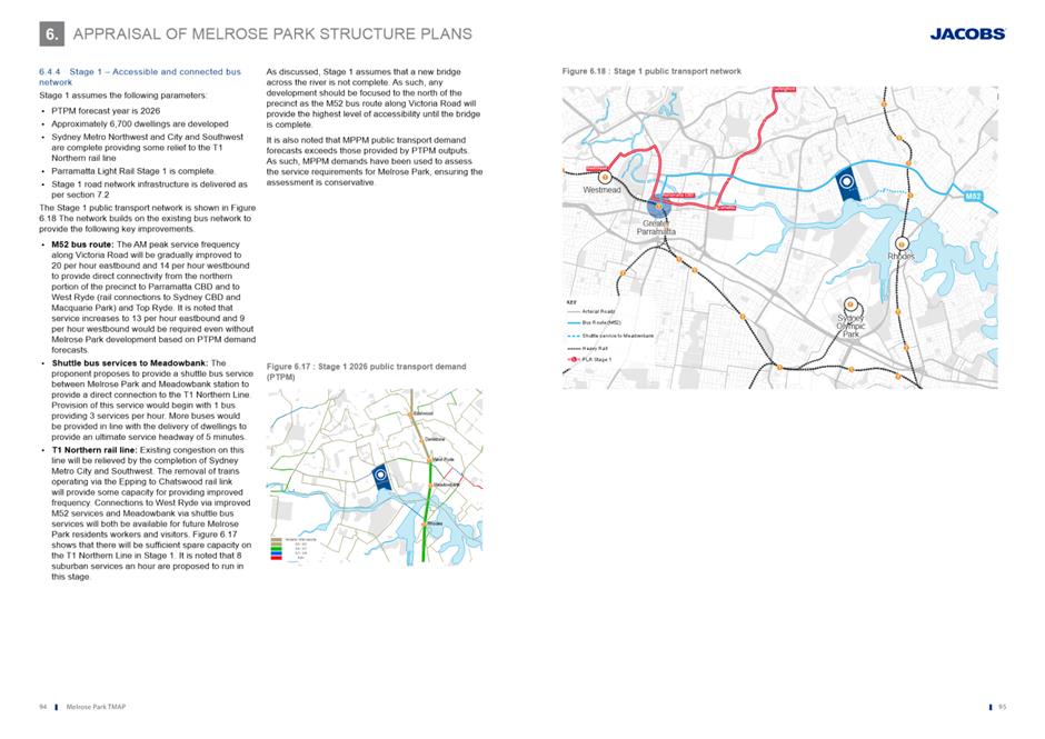
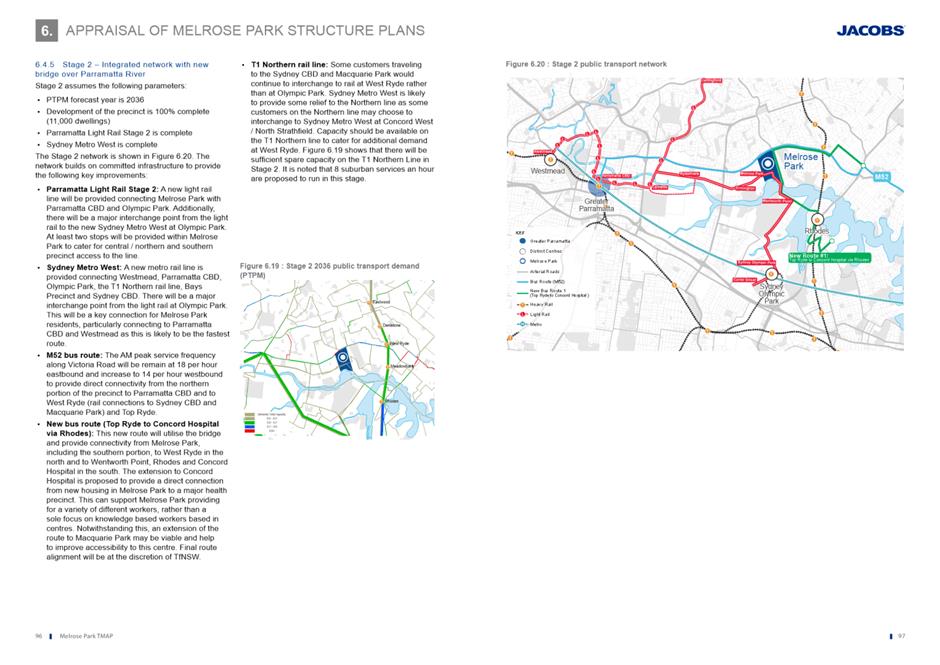
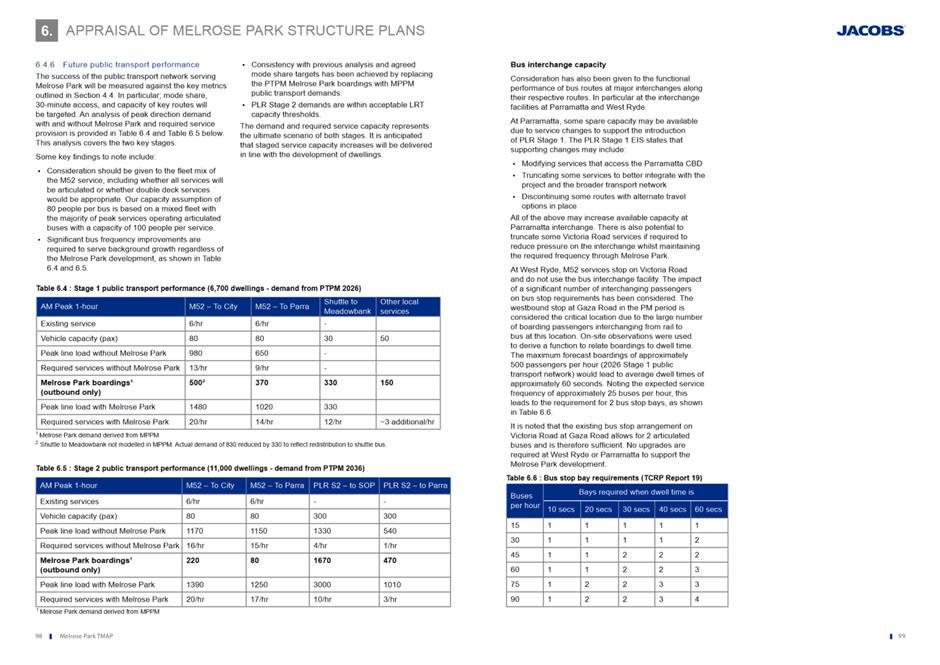
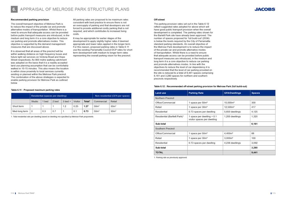
Local Planning Panel 29 September 2020 Item 5.1
ITEM NUMBER 5.1
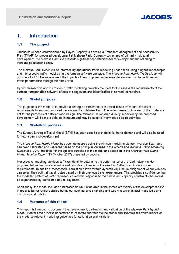
SUBJECT PUBLIC MEETING: Gateway Request: Planning Proposal for land at 112 Wharf Road, 30 & 32 Waratah Street, Melrose Park and 82 Hughes Avenue, Ermington
REFERENCE RZ/1/2020 -
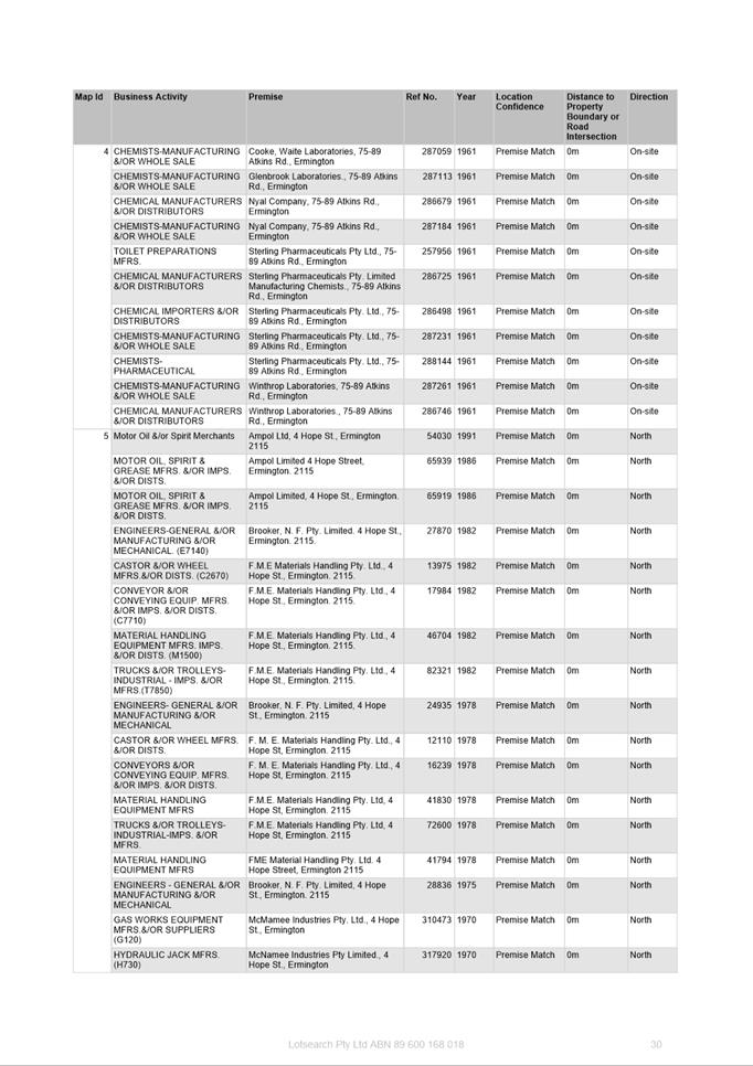
APPLICANT/S Holdmark Property Group
OWNERS Holdmark Property Group
REPORT OF Senior Project Officer Land Use Planning
Development applications considered by Sydney central city planning panel Nil
PURPOSE
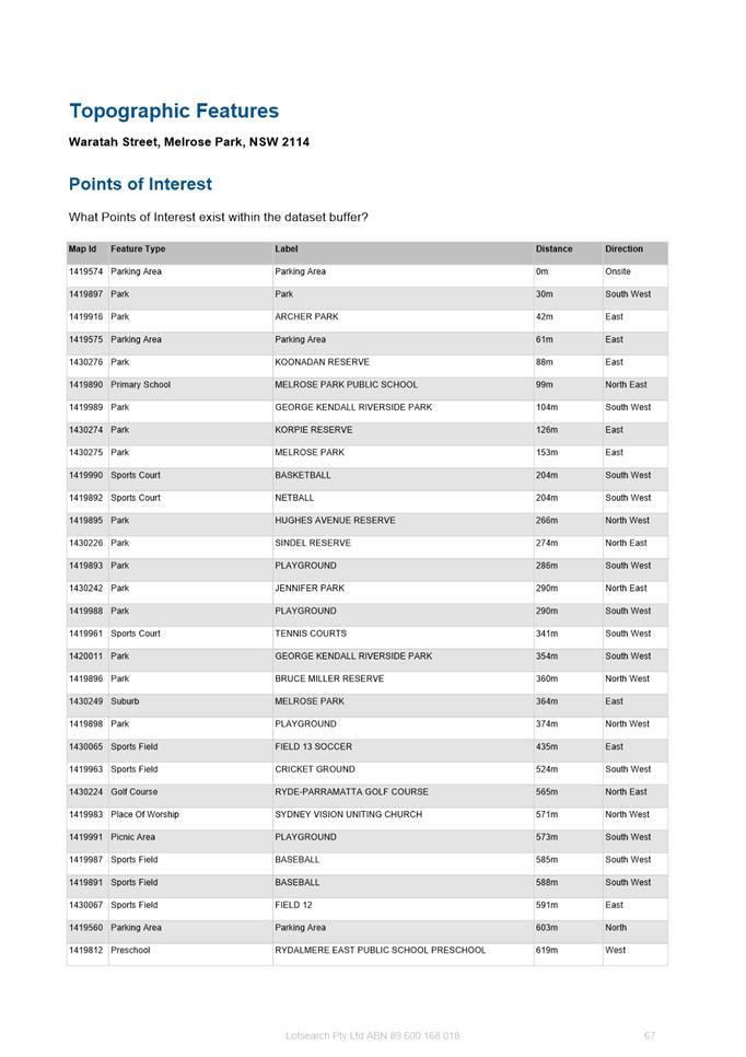
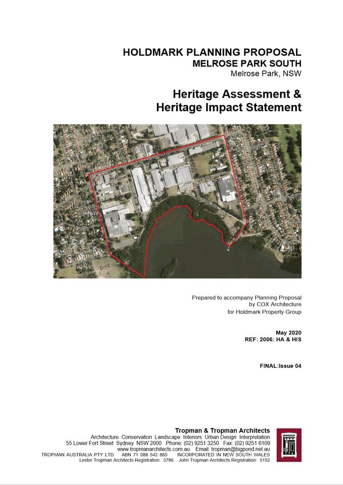
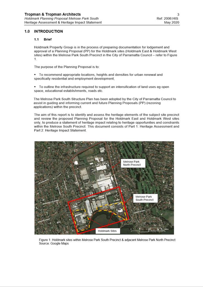
The purpose of this report is to seek the Local Planning Panel’s advice to Council on a request to the Department of Planning, Industry and Environment for a Gateway Determination for a Planning Proposal for land at 112 Wharf Road, 30 Waratah Street and 32 Waratah Street (also known as 1 Mary Street), Melrose Park and 82 Hughes Avenue, Ermington.
That the Local Planning Panel consider the following Council officer recommendation in its advice to Council:
(a) That Council endorse for the purposes of seeking a Gateway Determination from the Department of Planning, Industry and Environment (DPIE), the Planning Proposal for land at 112 Wharf Road, 30 Waratah Street and 32 Waratah Street, Melrose Park and 82 Hughes Avenue, Ermington which seeks to amend Parramatta Local Environmental Plan 2011 (PLEP 2011) by:
1. Rezoning 112 Wharf Road, 32 Waratah Street and 82 Hughes Avenue from IN1 General Industrial to part R4 High Density Residential and part RE1 Public Recreation.
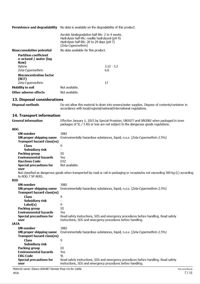
2. Rezoning 30 Waratah Street from IN1 General Industrial to RE1 Public Recreation.
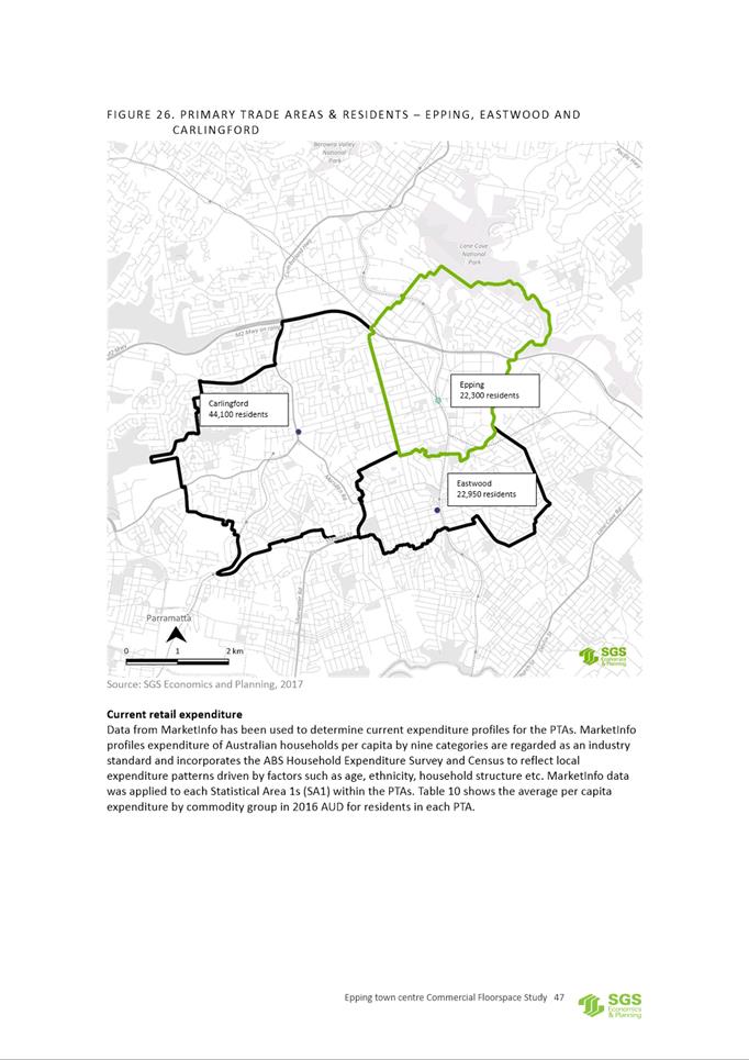
3. Amending the maximum building height from 12m to a combination of 34m, 45m and 77m (approximately 8, 12 and 22 storeys respectively).
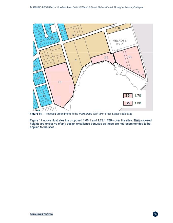
4. Amending the Floor Space Ratio (FSR) on the East site from 1:1 to 1.66:1.
5. Amending the FSR on the West site from 1:1 to 1.79:1.
6. Inserting a site-specific provision in Part 6 Additional local provisions – generally of PLEP 2011 and amending the Additional Local Provisions map to include the land to ensure:
6. 1 That design excellence provisions be applicable to buildings of 55m and above in height without the provision of bonuses.
6.2 A minimum of 1,000m2 of non-residential floor space is to be provided within the site to serve the local retail and commercial needs of the incoming population.
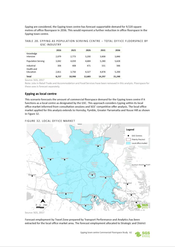
7. Amending the Land Reservation Acquisition map to reflect areas of open space to be dedicated to Council.
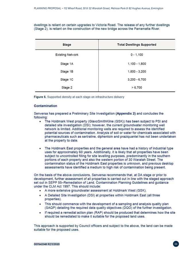
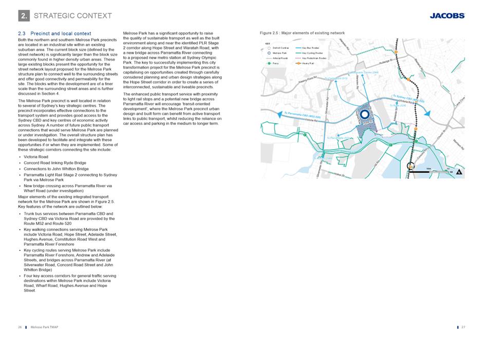
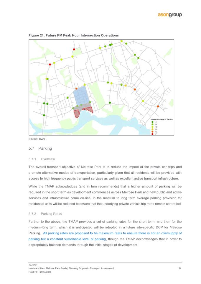
8. Inserting provisions into PLEP 2011 to ensure that the number of dwellings approved at the development application stage aligns with the delivery of the required infrastructure as identified by Council and in the TMAP as per the implementation plans endorsed by Council on 12 August 2019.
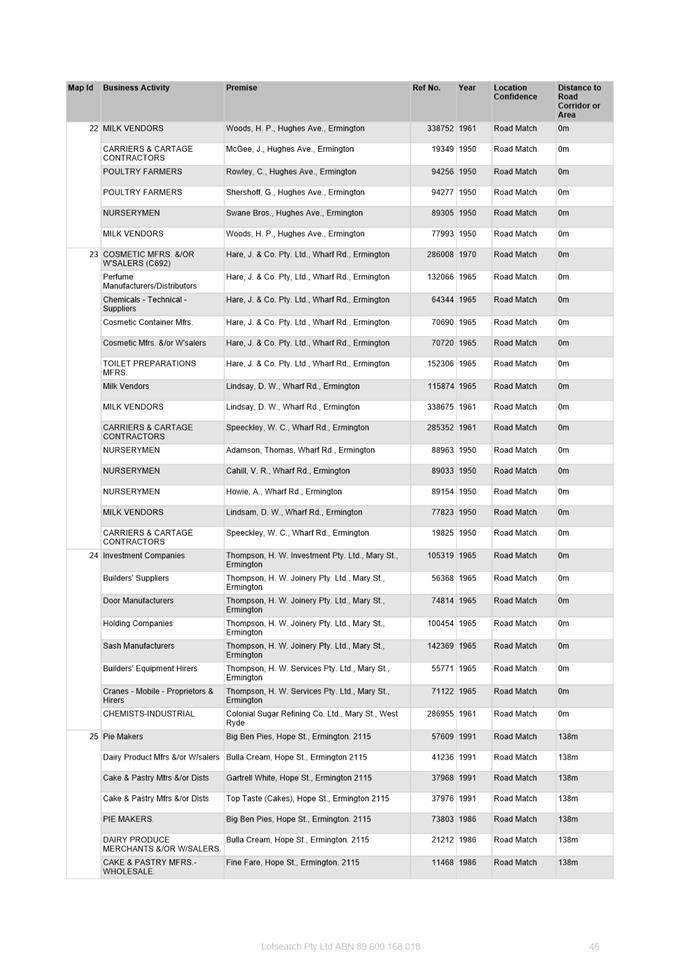
9. Amending Schedule 1 Additional Permitted Uses to permit ‘food and drink premises’ in the R4 High Density Residential zone.
(b) That the Planning Proposal be forwarded to the Department of Planning, Industry and Environment (DPIE) for Gateway determination.
(c) That a site-specific Development Control Plan (DCP) be prepared and reported to Council prior to formal exhibition of the Planning Proposal.
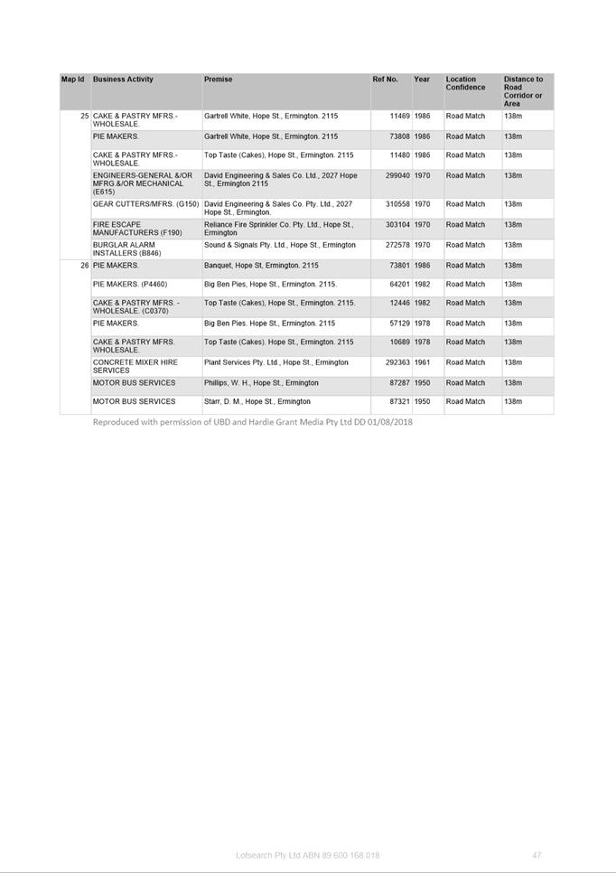
(d) That Council delegates authority to the CEO to commence negotiations to enter into a planning agreement with the applicant in relation to infrastructure provision required to support the proposal and that any planning agreement entered into is:
1. in addition to developer contributions payable; and
2. reported to Council prior to public exhibition.
(e) That the site-specific DCP and Planning Agreement be publicly exhibited concurrently with the Planning Proposal should Gateway determination be issued.
(f) That Council advises the DPIE that the CEO will be not be seeking to exercise its plan-making delegations for this Planning Proposal, as authorised by Council on 26 November 2012.
(g) Further, that Council delegates authority to the CEO to correct any minor anomalies of a non-policy and administrative nature that arise during the plan-making process.
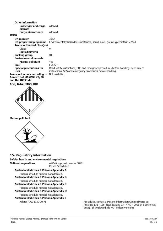
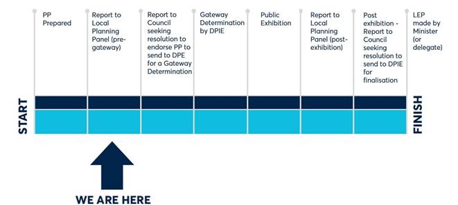
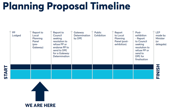
PLANNING PROPOSAL TIMELINE
SUMMARY
1. This report seeks the Local Planning Panel’s (LPP) endorsement to forward a Planning Proposal for land at 112 Wharf Road, 30 Waratah Street and 32 Waratah Street, Melrose Park and 82 Hughes Avenue, Ermington in accordance with the recommendations outlined in this report to the Department of Planning, Industry and Environment (DPIE) for Gateway determination.
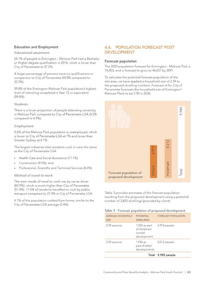
2. The Planning Proposal seeks to amend Parramatta Local Environmental Plan (PLEP) 2011 to enable non-industrial development on these sites in the form of high density residential and public open space uses generally in accordance with the adopted Melrose Park Southern Structure Plan (Southern Structure Plan) adopted by Council on 16 December 2019. Should the Planning Proposal proceed then approximately 1,925 units could potentially be delivered on the site with building heights ranging from 8 storeys to 22 storeys.
3. The Planning Proposal has been assessed against the adopted structure plan and is considered acceptable by Council officers to proceed to Gateway determination. It is recommended that a site-specific DCP be prepared to address the specific built form requirements and that a planning agreement be entered into between the developer and Council to ensure the infrastructure needs of the precinct are addressed.
BACKGROUND
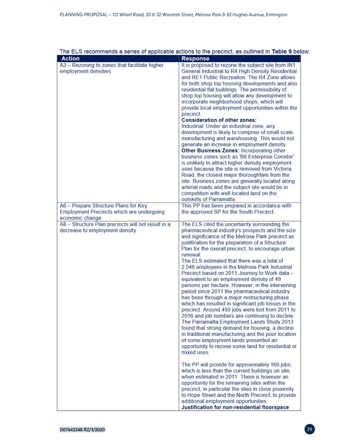
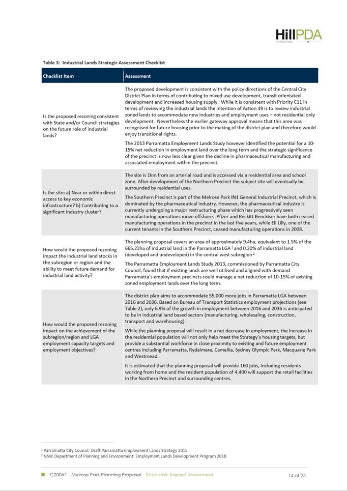
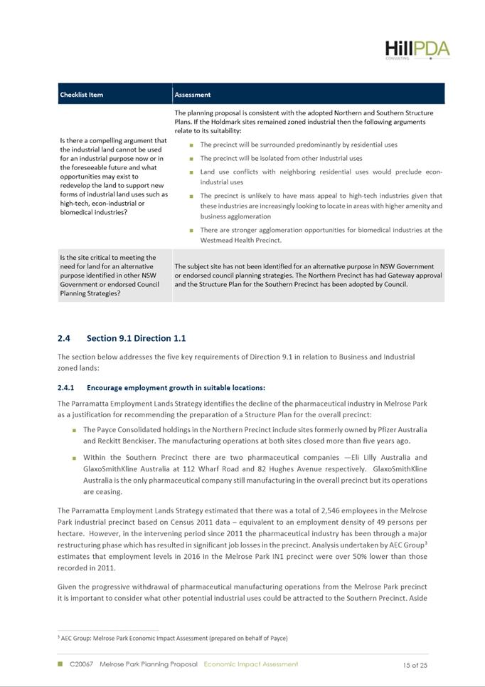
4. Council adopted the Parramatta Employment Lands Strategy (ELS) at its meeting of 11 July 2016, which identified the Melrose Park industrial area precinct as being a Structure Plan precinct and suitable for redevelopment for non-industrial uses. This was primarily due to a decline in the pharmaceutical manufacturing industry, which had a significant presence within the precinct.
5. In May 2016, a Planning Proposal was lodged by the applicant relating to 112 Wharf Road, 30 Waratah Street and 32 Waratah Street, Melrose Park, however this was not progressed due to the requirement within the adopted ELS to first prepare a structure plan for the precinct before any planning proposals could be progressed.
6. It was initially intended that one structure plan would be prepared for the whole Melrose Park precinct. However, in July 2016, Council resolved to consider the structure planning of Melrose Park precinct in two parts (a Northern Structure Plan and Southern Structure Plan) to enable redevelopment of the precinct to be progressed in a timeframe that suited the landowners in both the northern and southern precincts.
7. In August 2016, Council resolved to exhibit the draft Northern Structure Plan and supporting documents, and it was adopted by Council on 12 December 2016. Since this time, the Melrose Park North Planning Proposal has received Gateway determination and the draft site-specific DCP and Planning Agreement preparations are now taking place to enable the public exhibition of the proposed planning provisions in the northern precinct to occur.
8. In late 2016, two major landowners within the southern precinct, Holdmark and Goodman, collaborated to prepare a draft Structure Plan on behalf of all landowners in the southern precinct.
9. Over the course of 2017 and 2018, multiple versions of the draft Structure Plan were prepared and considered by Council officers with the final draft version adopted by Council for the purposes of public exhibition on 24 June 2019. The draft Southern Structure Plan was subsequently placed on public exhibition from 14 August to 10 September 2019.
10. As a result of feedback received during the public exhibition, a number of amendments were made to the draft Structure Plan and a revised version was reported to and endorsed by Council on 16 December 2019.
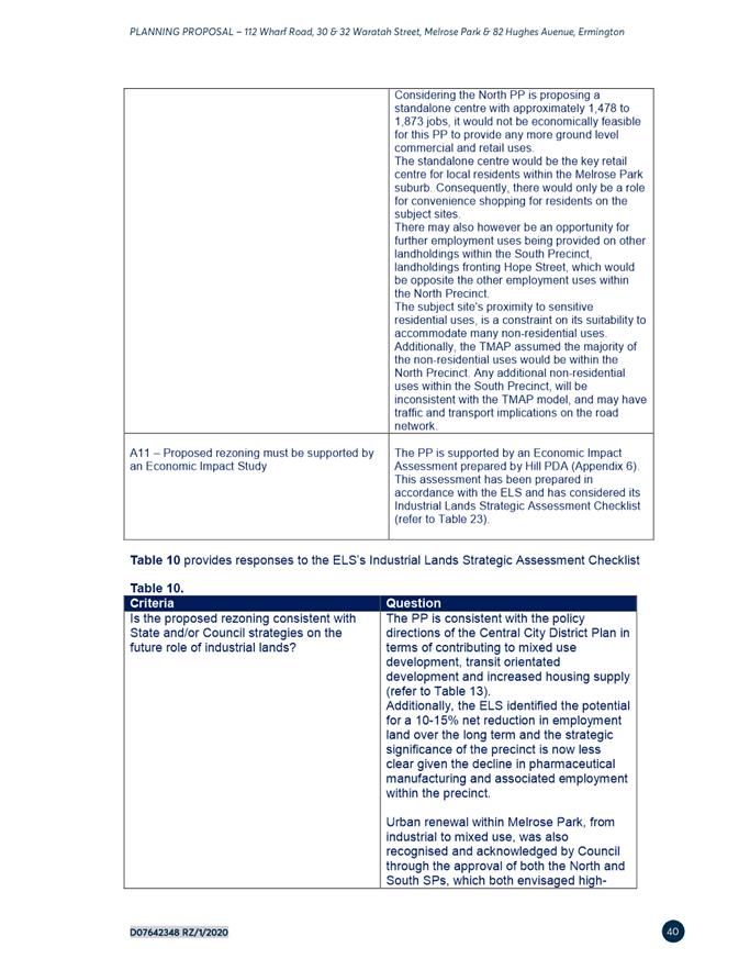
11. Upon finalisation of the Southern Structure Plan it is now possible to proceed with planning proposals for land in the southern precinct in accordance with the framework endorsed by Council for both the northern and southern precincts.
12. As a result, the applicant has subsequently revised their original Planning Proposal to reflect the requirements of the Southern Structure Plan and also incorporate the additional property at 82 Hughes Avenue which was purchased during the preparation of the structure plan. This report considers the revised planning proposal that was lodged with Council on 11 May 2020.
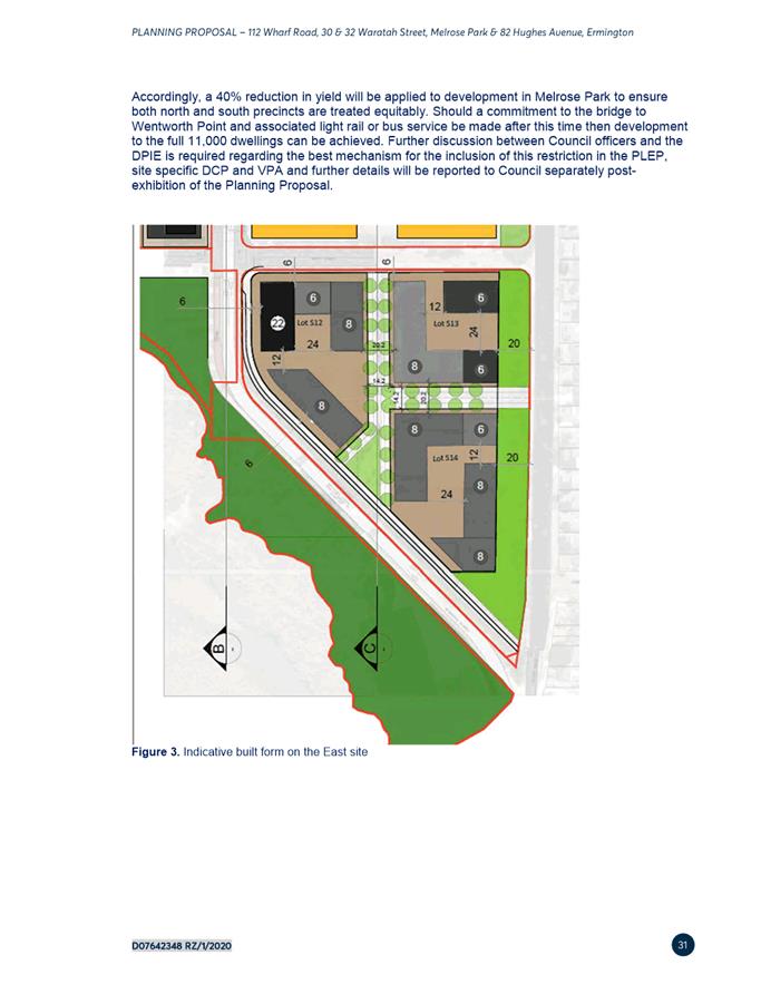
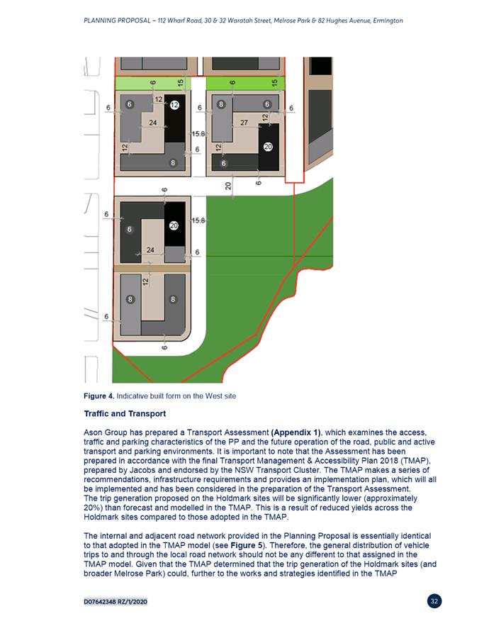
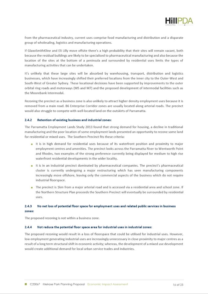
SOUTHERN STRUCTURE PLAN
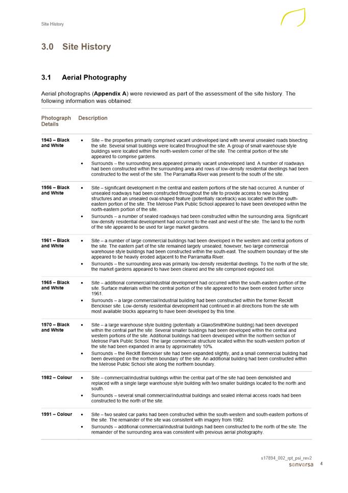
13. A structure plan is intended to act as a guiding document for future redevelopment of an area and provide high-level strategic principles for development, which is evident in the Northern Structure Plan. However, due to the large number of landowners and likelihood that the southern precinct will redevelop at various stages, the Southern Structure Plan was required to adopt a more detailed approach to ensure the vision and desired character would be achieved.
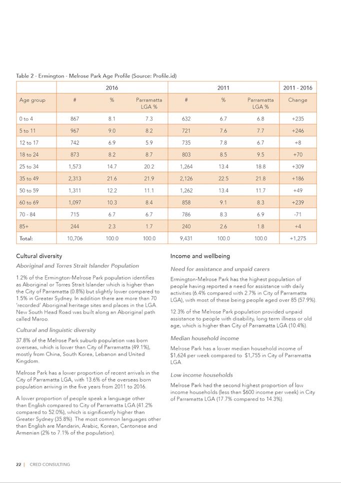
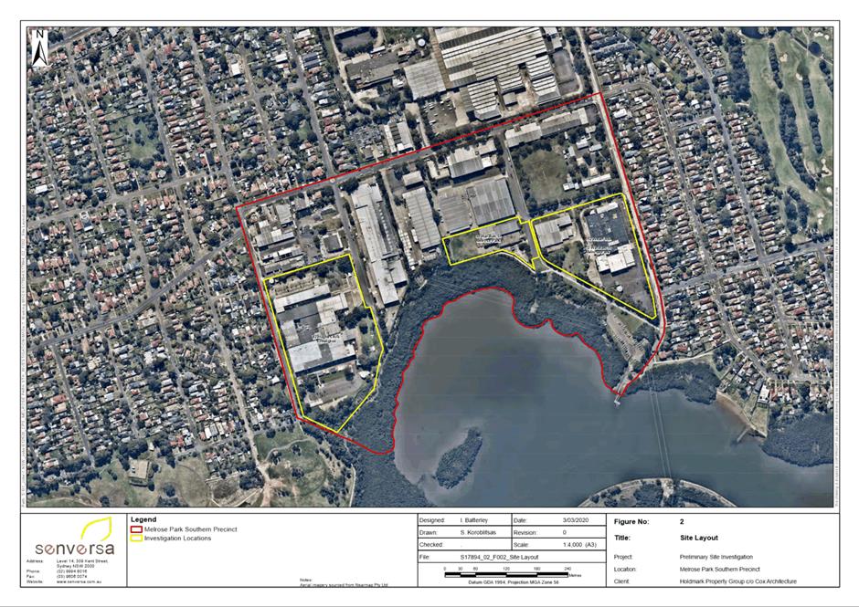
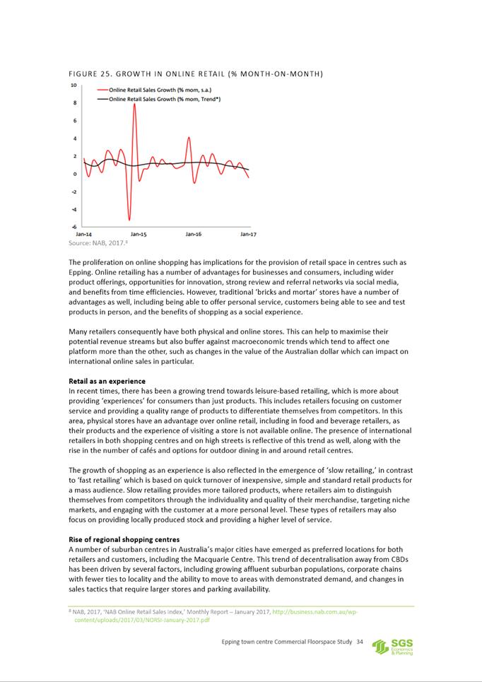
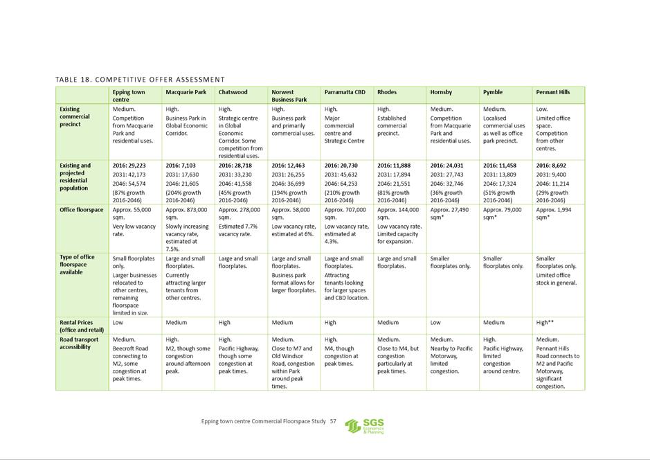
14. As a result, the Southern Structure Plan was subject to a greater level of urban design testing and provides an indicative development scheme (refer to Figure 1) for the precinct that achieves the Council-endorsed maximum FSR of 1.7:1 across the southern precinct. The structure plan also seeks to identify indicative densities by applying FSRs and maximum buildings heights to individual development lots and provides indicative locations of open space and new roads (refer to Figure 2).
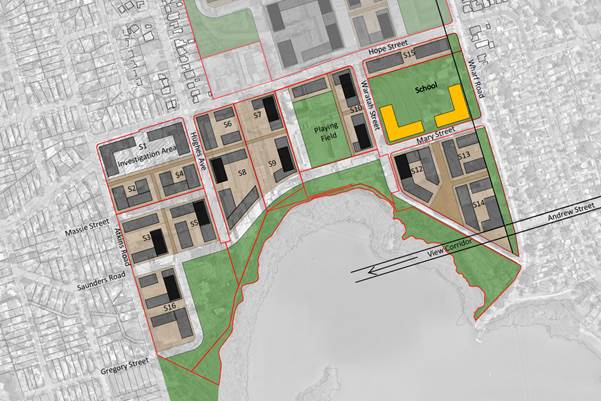
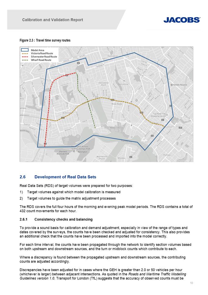
Figure 1. Adopted indicative development scheme for the southern precinct
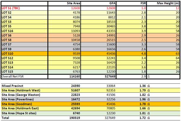
Figure 2. Adopted density table for the southern precinct
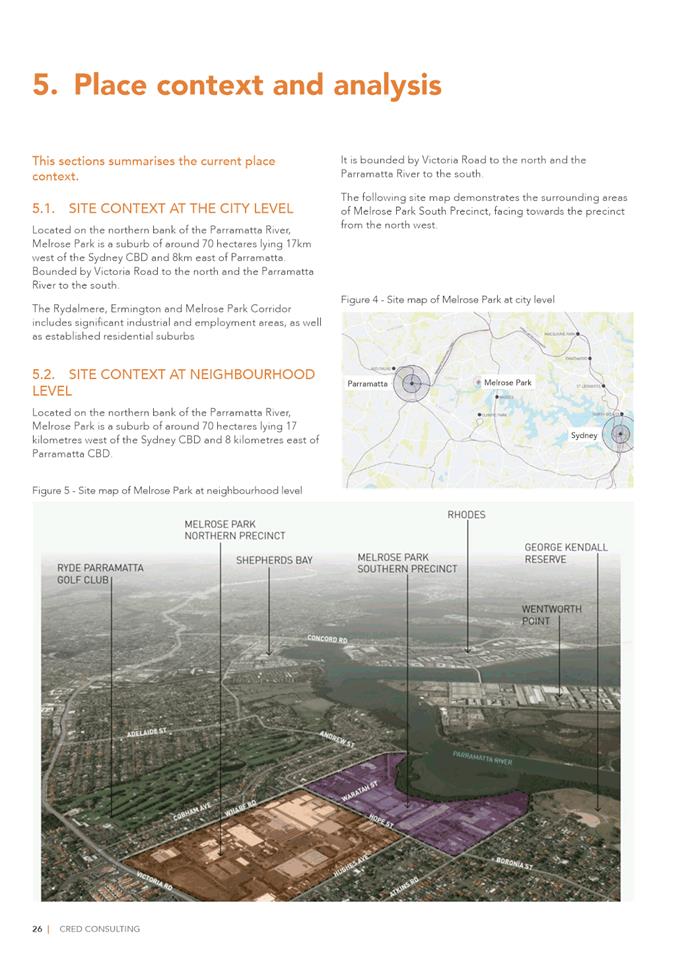
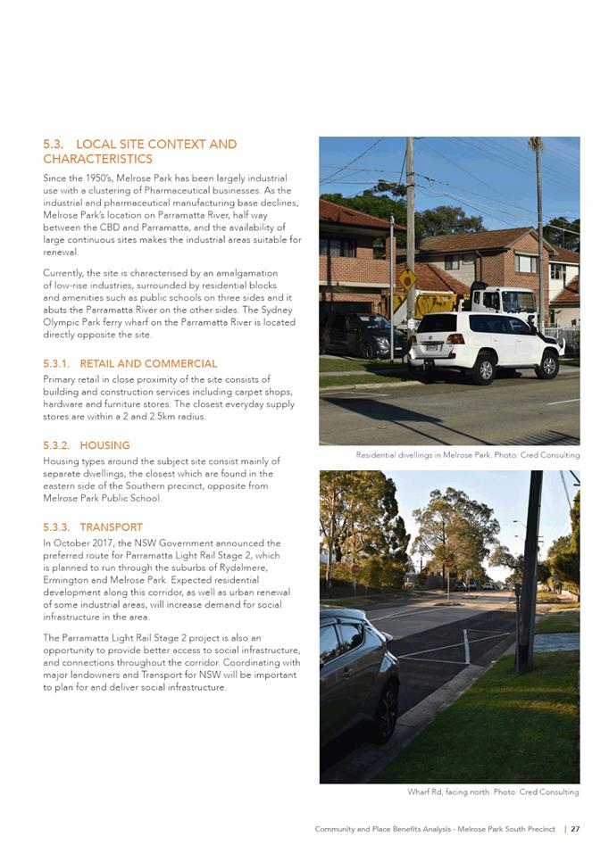
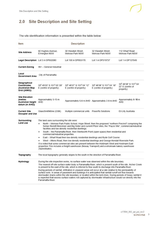
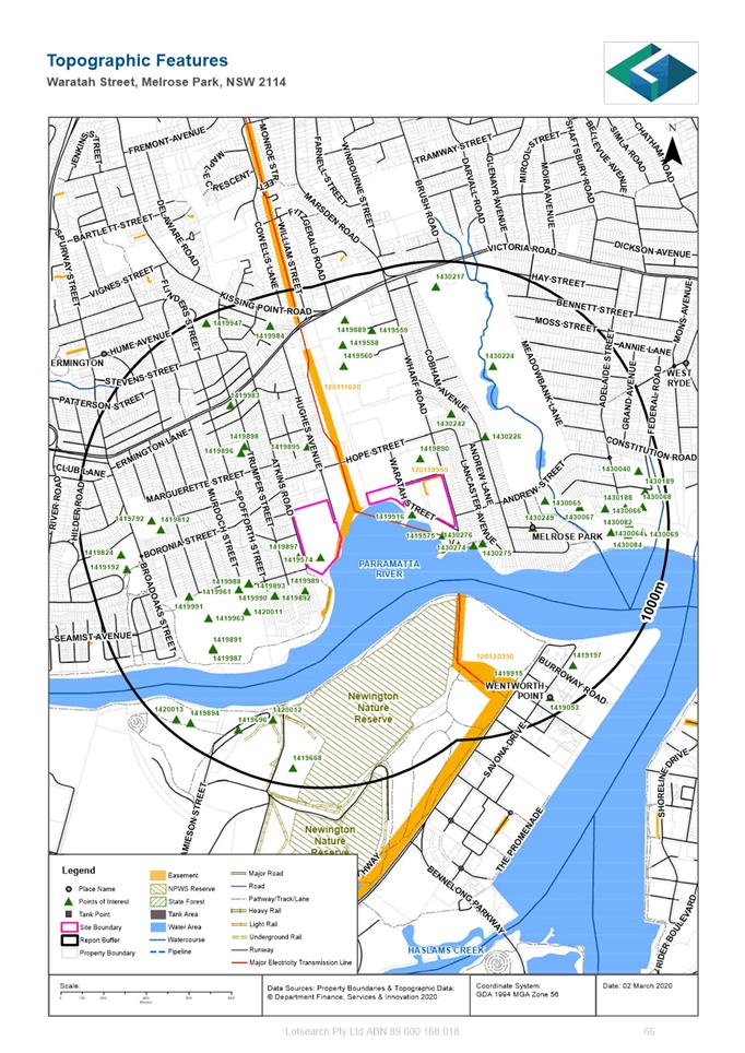
SITE CONTEXT AND DESCRIPTION
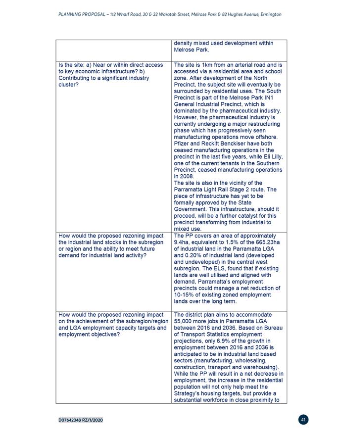
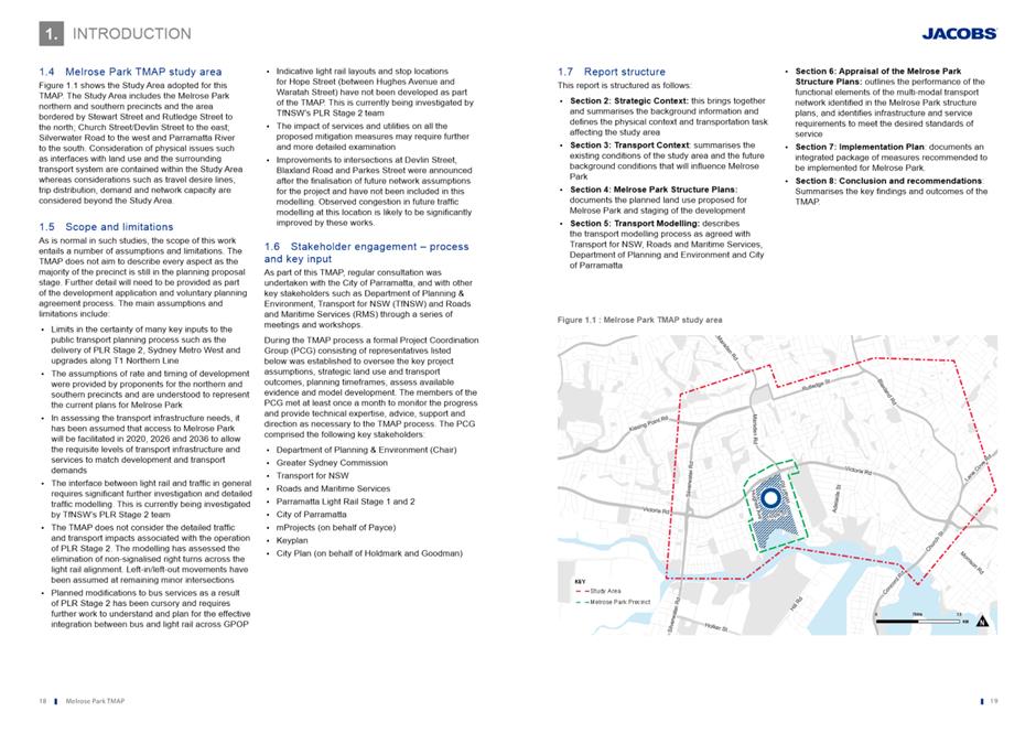
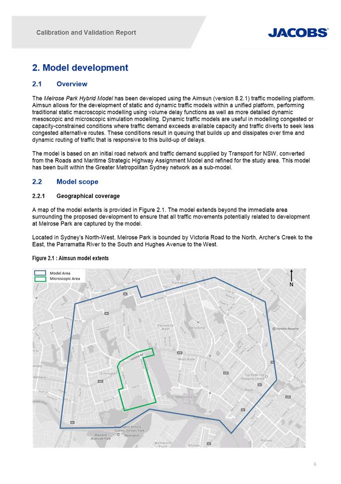
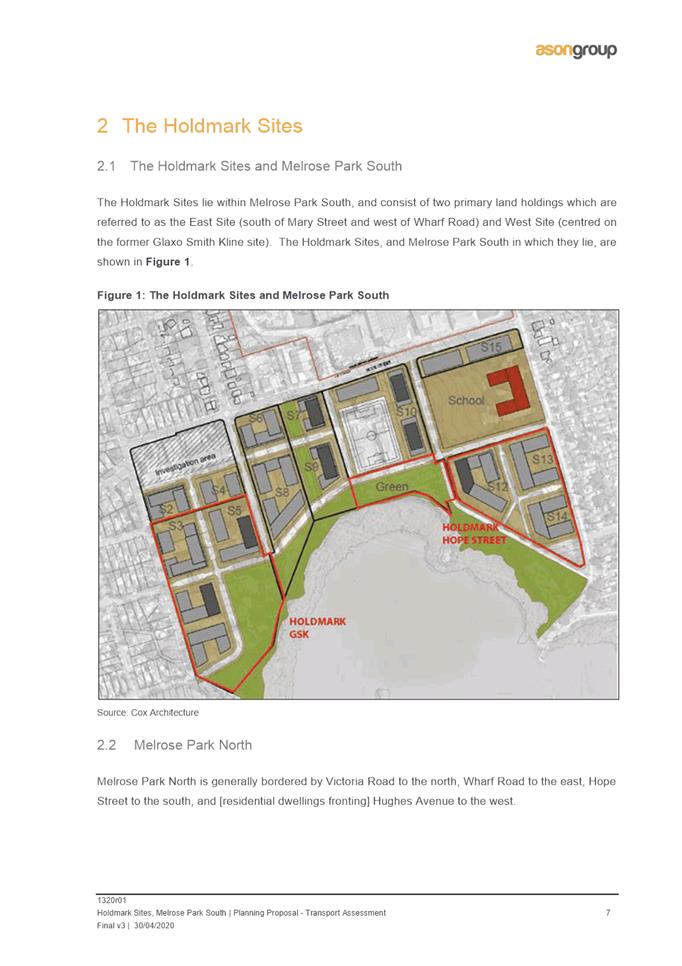
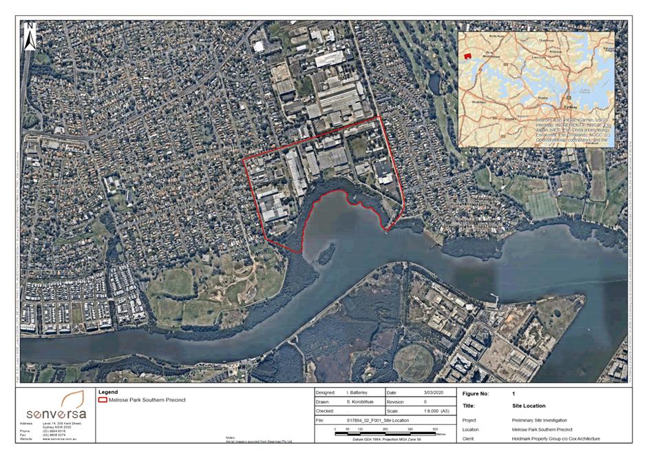
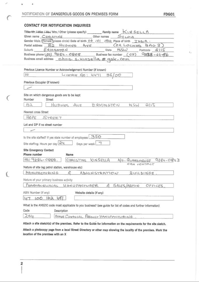
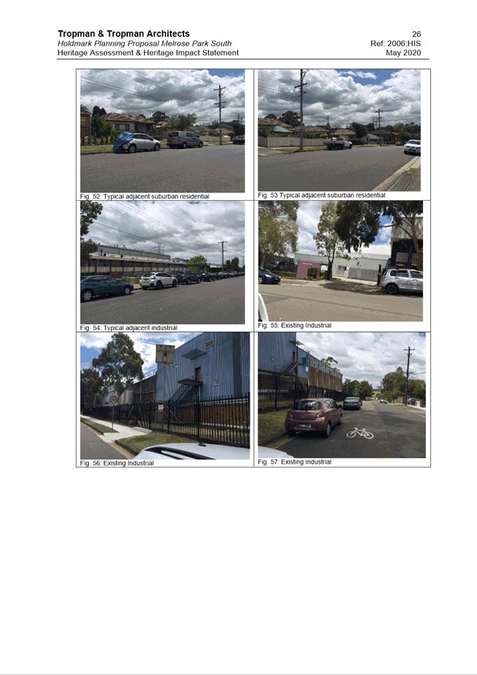
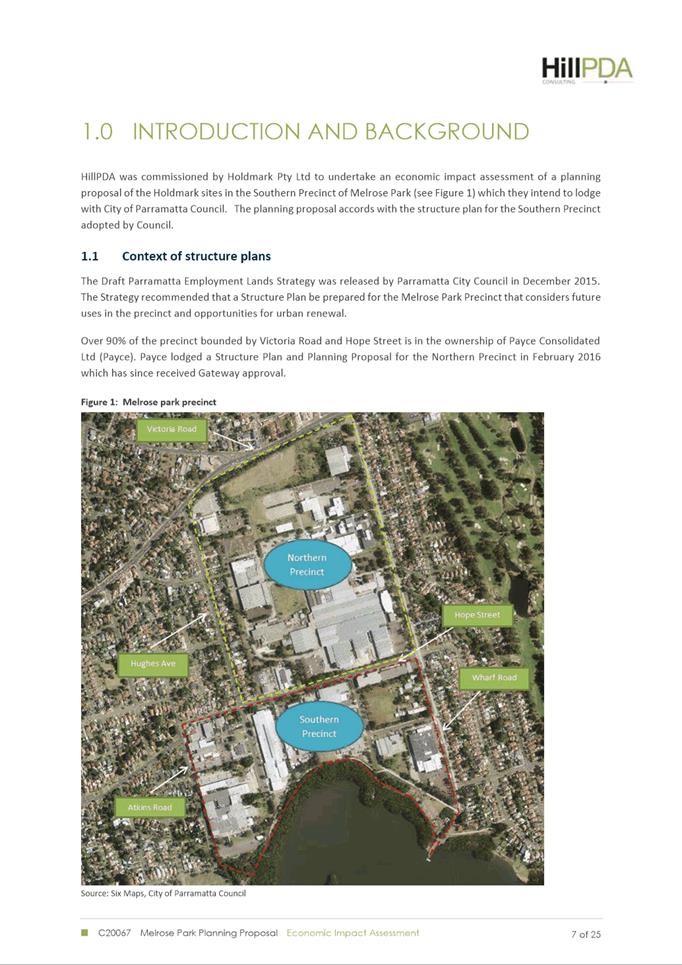
15. The southern precinct is bound by Hope Street to the north, Wharf Road to the east, Parramatta River to the south and Atkins Road to the west. It is located approximately 6km east of the Parramatta CBD and adjoins the Ryde Local Government Area (LGA). The structure plan area is approximately 19ha in size and consists of 22 land parcels and 20 separate ownerships in addition to multiple strata-owned properties.
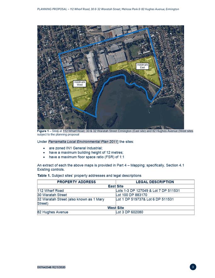
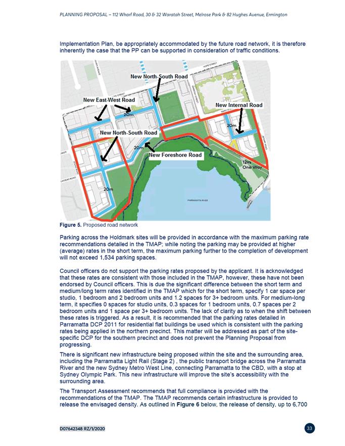
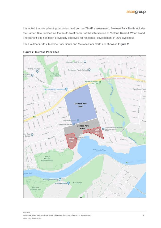
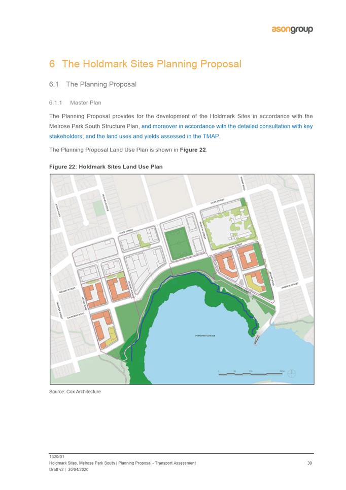
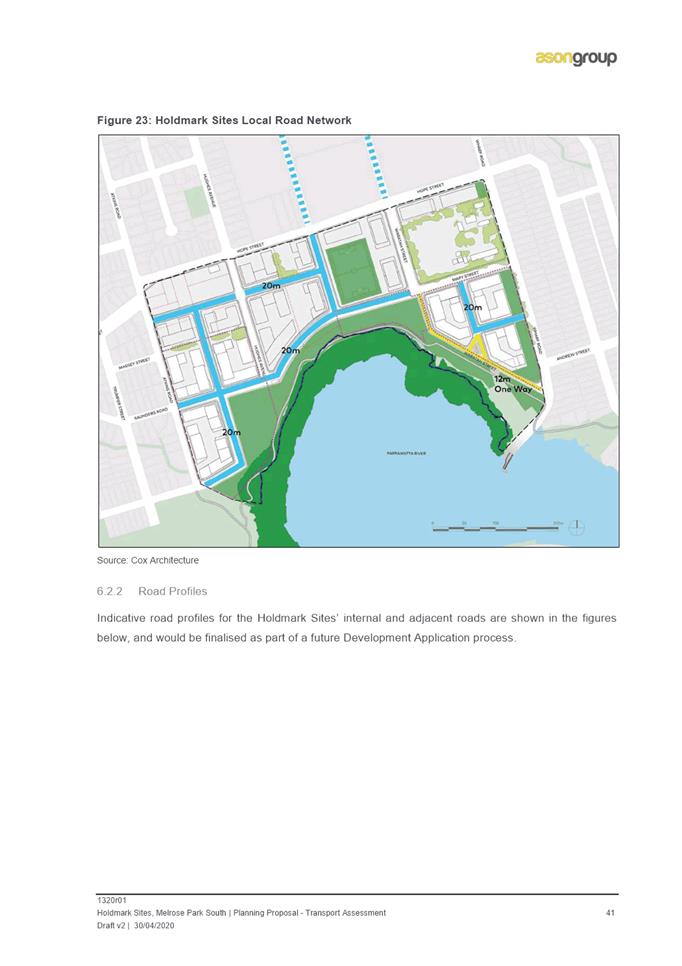
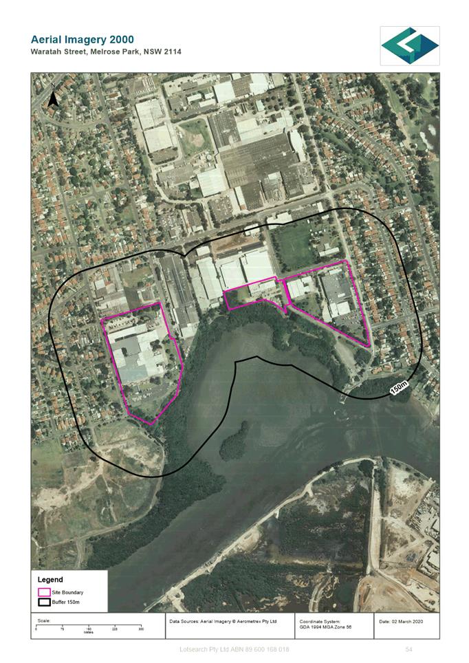
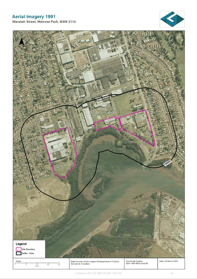
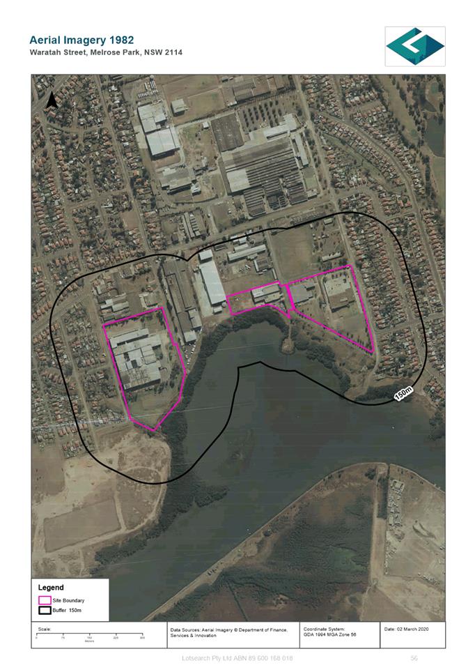
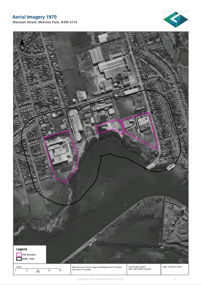
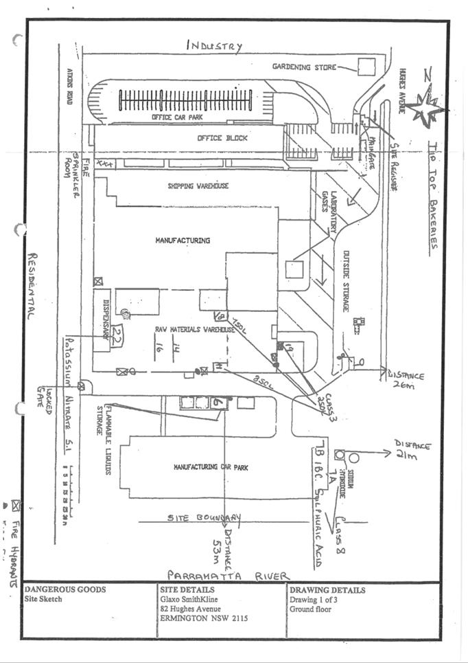
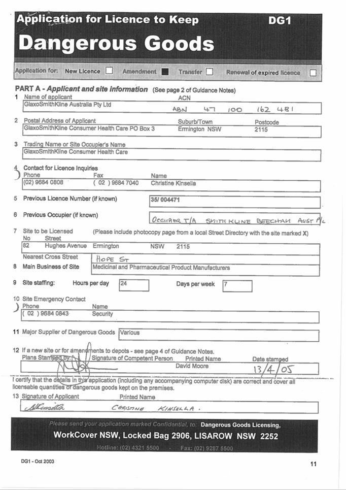
16. The sites subject to this Planning Proposal are located in the eastern and western sides of the southern precinct. The eastern site, which relates to the 112 Wharf Road, 30 and 32 Waratah Street is approximately 42,692m2 (4.2ha) in area located to the south of Melrose Park Public School. The western site was formerly owned by Glaxo Smith Kline and is approximately 51,607m2 (5.1ha) and bound by Hughes Avenue to the east, Parramatta River to the south, Atkins Road to the west and 71 Atkins Road and 80 Hughes Avenue along the northern boundary. For the purposes of clarity, these sites will be referred to as “East” and “West” respectively in this report. Refer to Figure 3 for the locations of the East and West sites that are subject to the Planning Proposal.
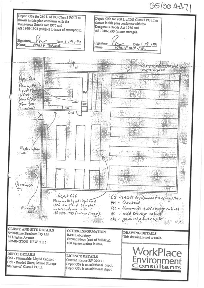
17. The sites are currently largely heavily developed and occupied by a variety of industrial premises. The East site includes pharmaceutical, engineering and plastics manufacturing. The West site includes purpose-built pharmaceutical manufacturing buildings.
18. Surrounding land uses include low density residential in both the Parramatta and Ryde LGAs to the east and west, Parramatta River to the south and industrial land between both sites.
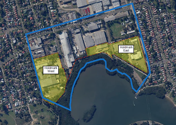
Figure 3. Sites subject to this Planning Proposal
19. Access to the sites is primarily provided from Wharf Road and Atkins Road. These roads service residential and commercial traffic and have carrying capacity for large trucks.
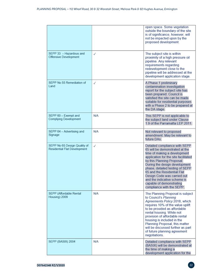
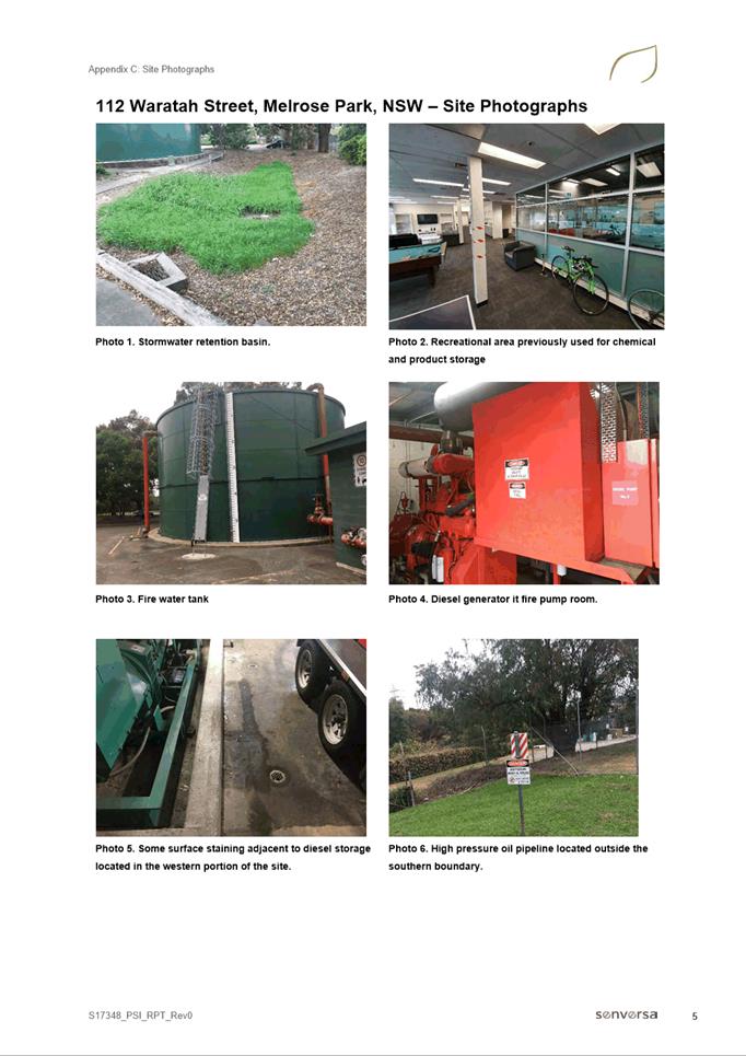
20. The sites are developed and therefore have existing water, sewer, telecommunications and gas trunk services. These services will need to be augmented to service the proposed higher intensity development. A high pressure oil pipeline is also located adjacent to the East site along Waratah Street.
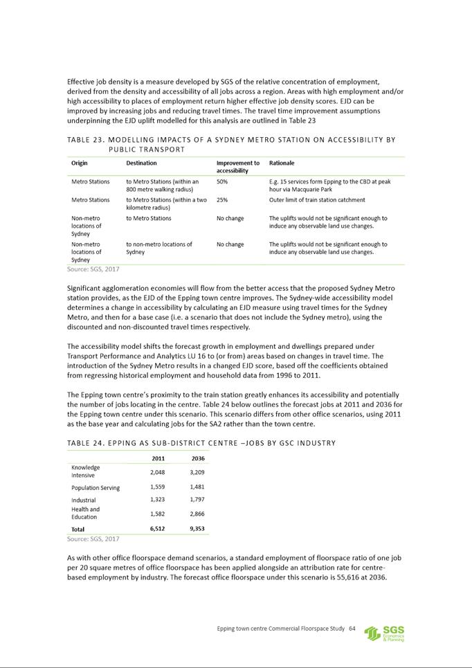
CURRENT PLANNING CONTROLS
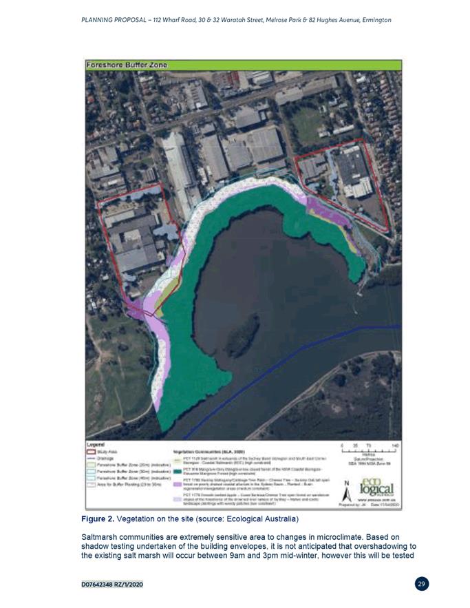
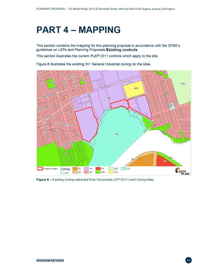
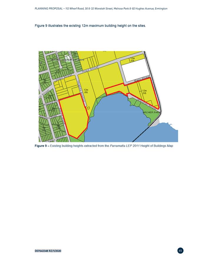
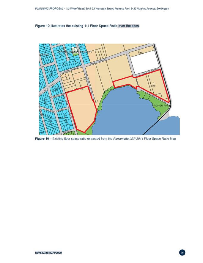
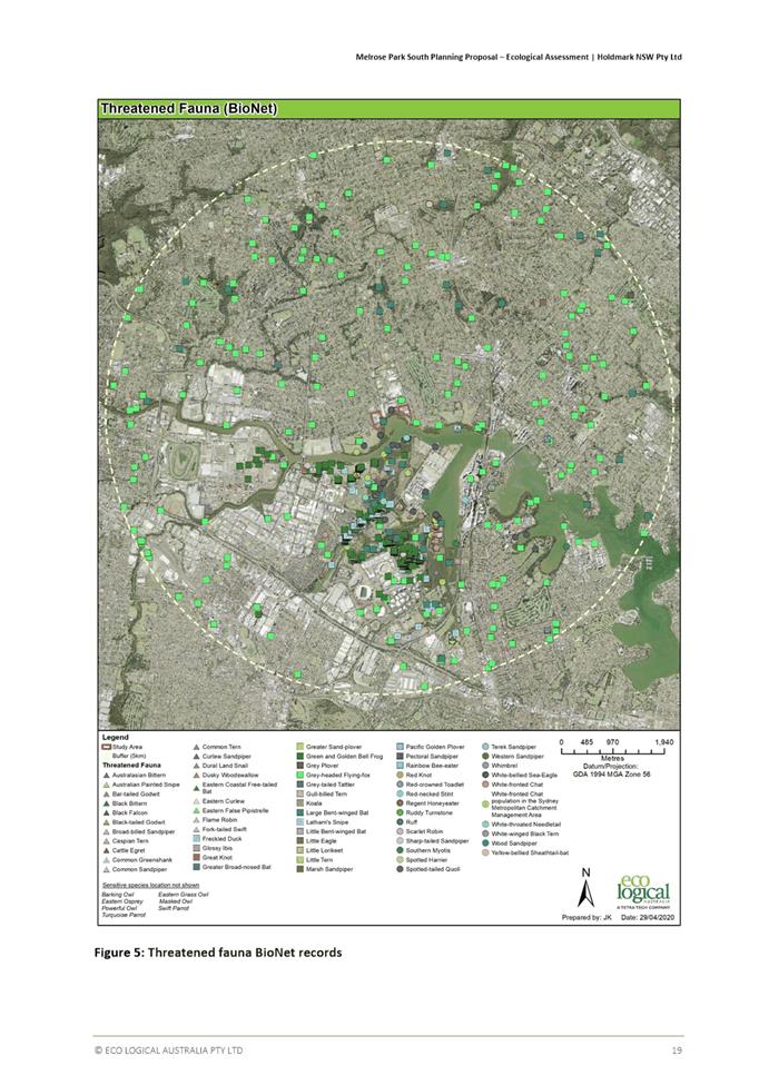
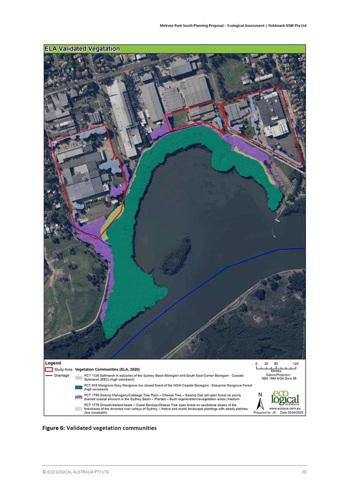
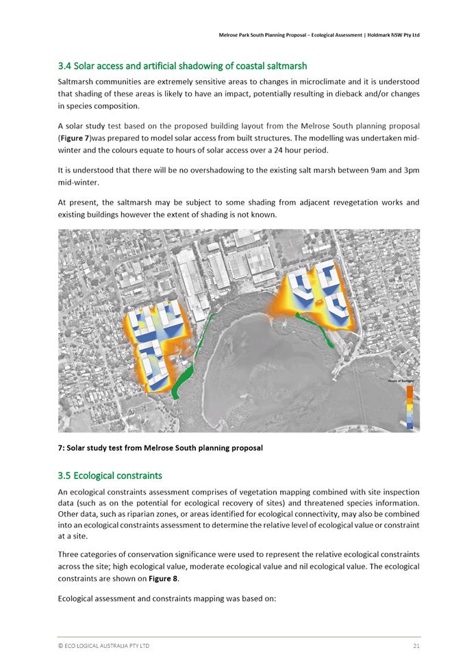
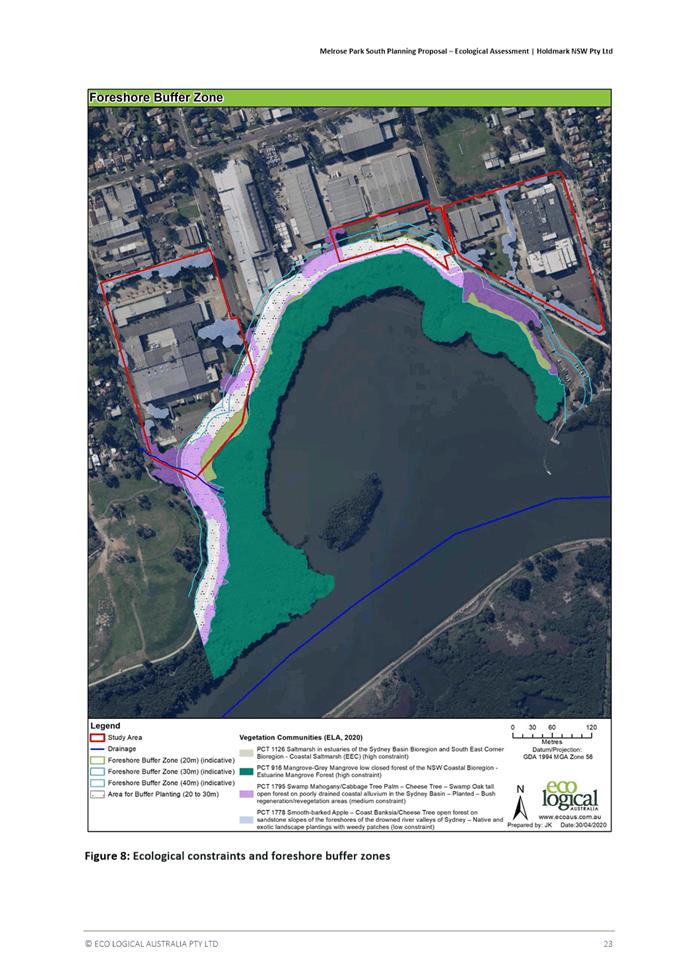
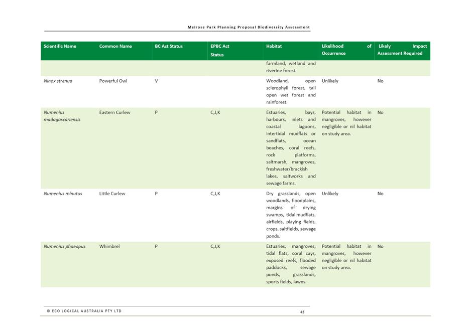
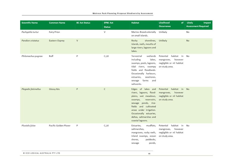
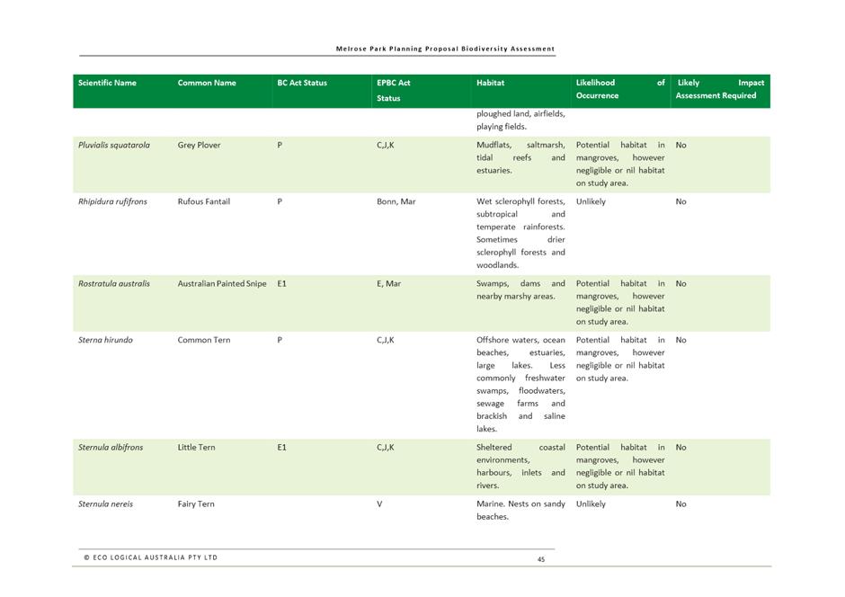
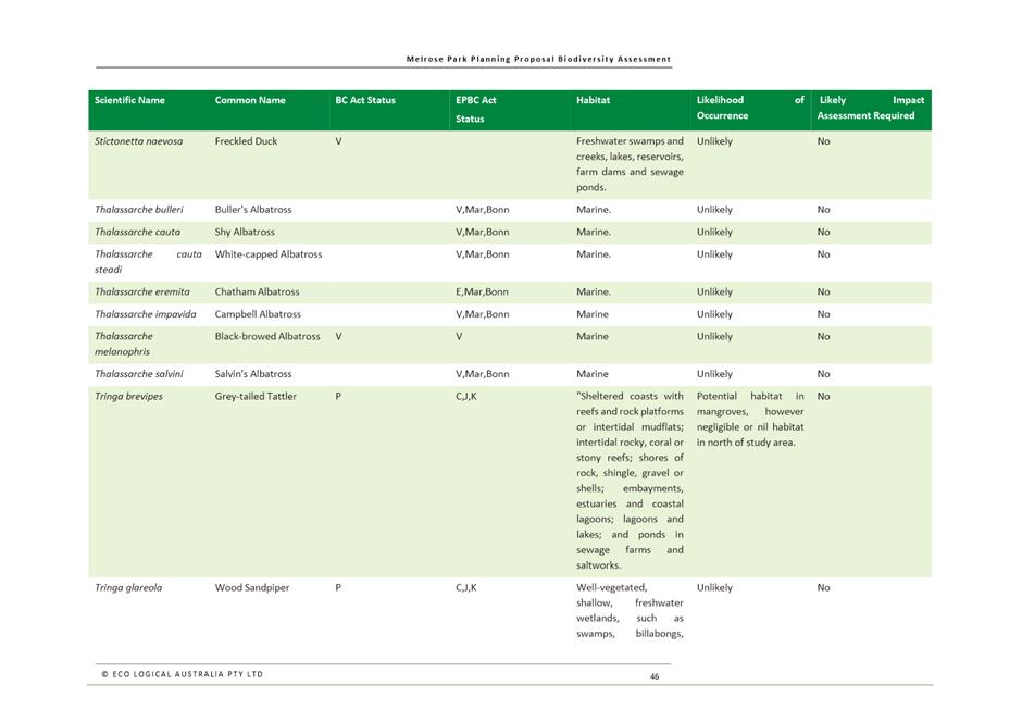
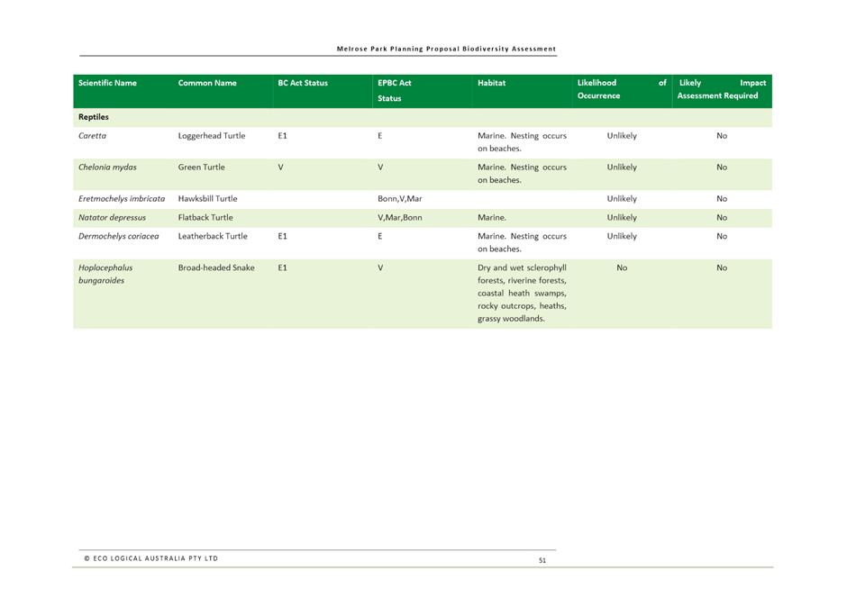
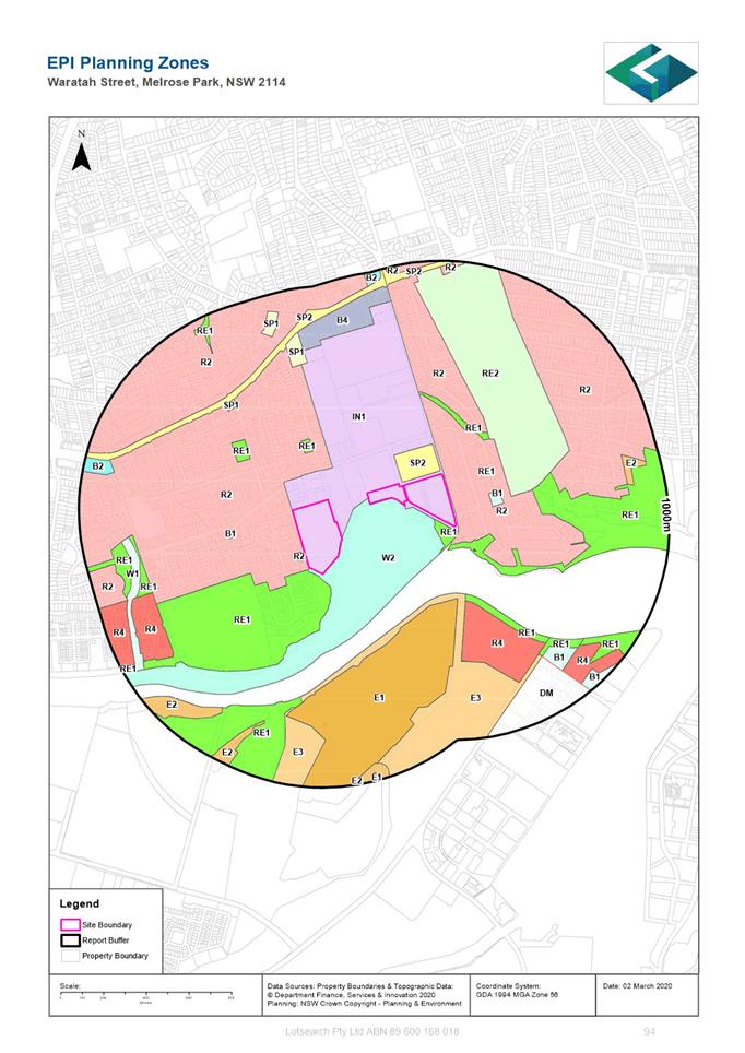
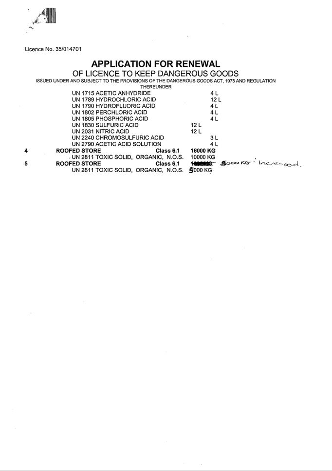
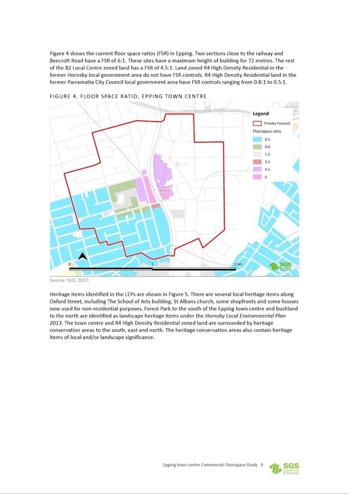
21. Both the East and West sites are currently zoned IN1 General Industrial with an FSR of 1:1 and maximum building height of 12m. Refer to Figures 4, 5 and 6.
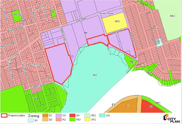
Figure 4. Current land use zone applicable to the sites
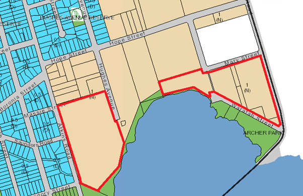
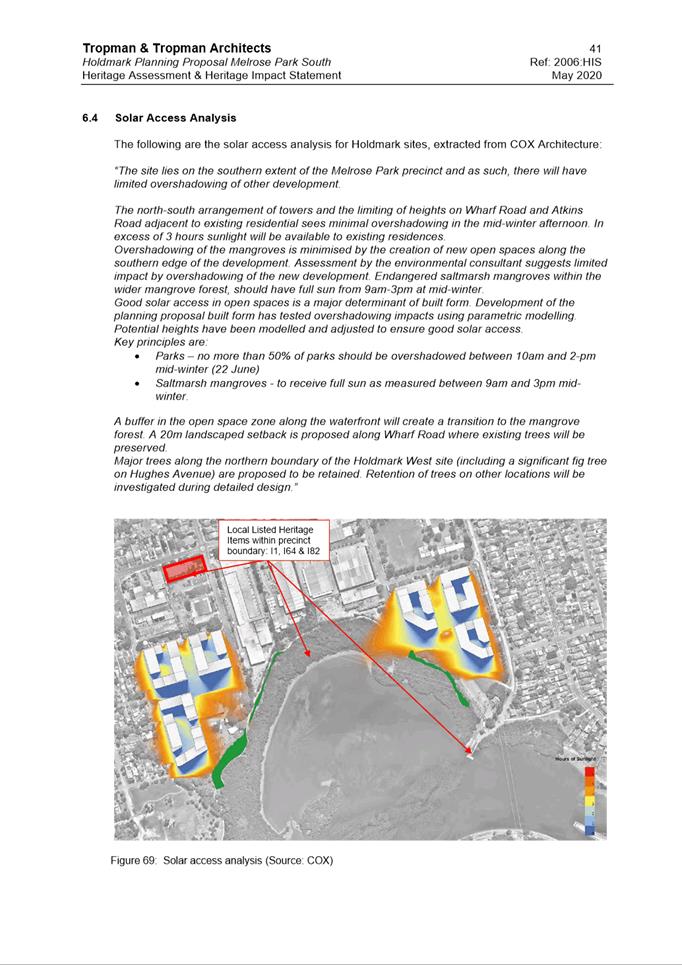
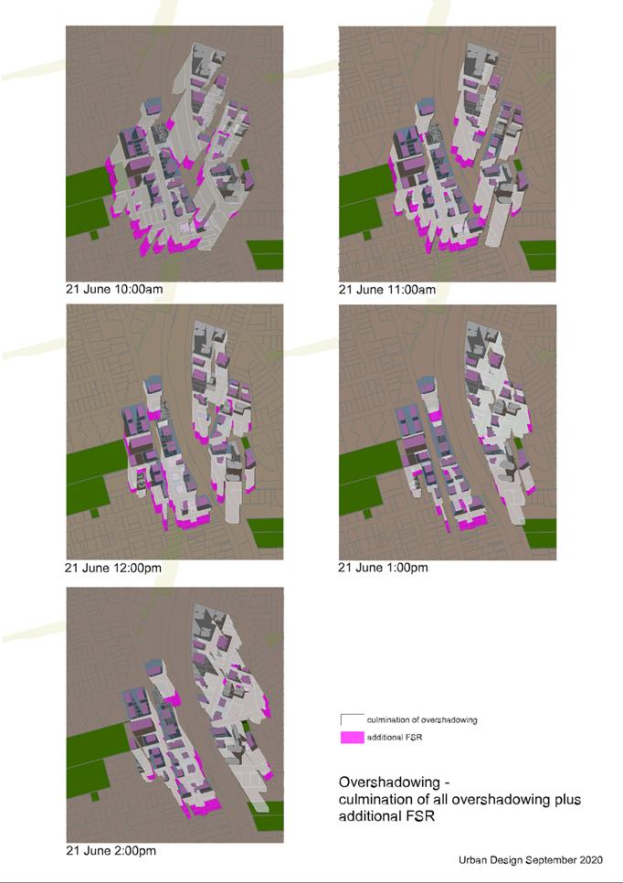
Figure 5. Current FSR applicable to the sites
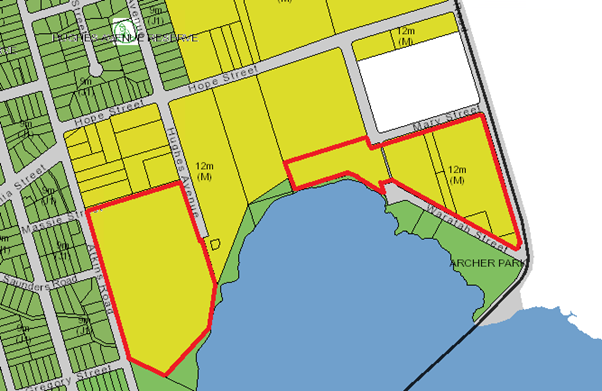
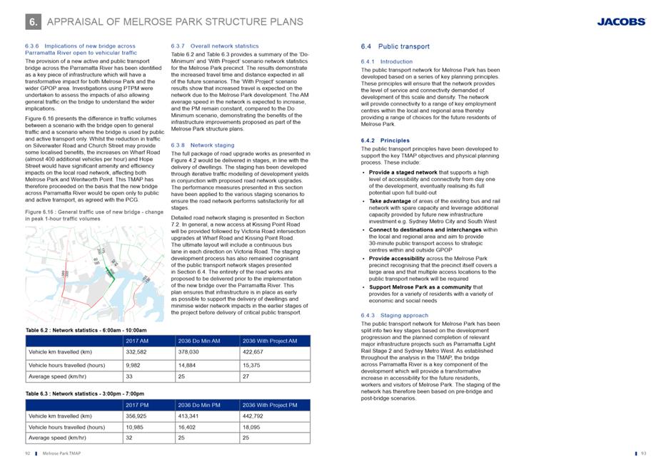
Figure 6. Current applicable building height applicable to the site
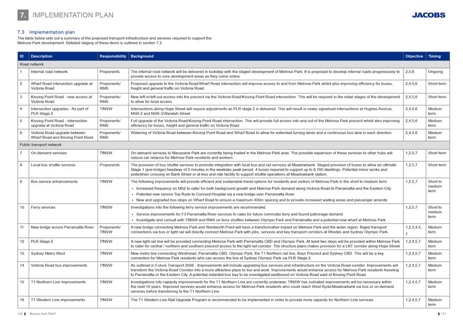
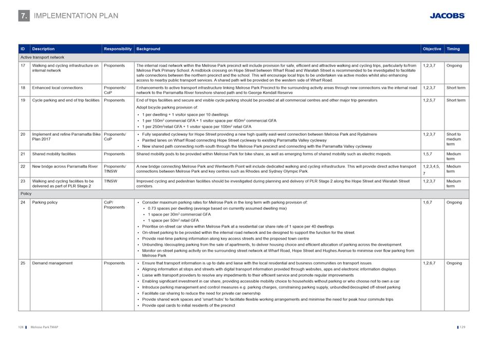
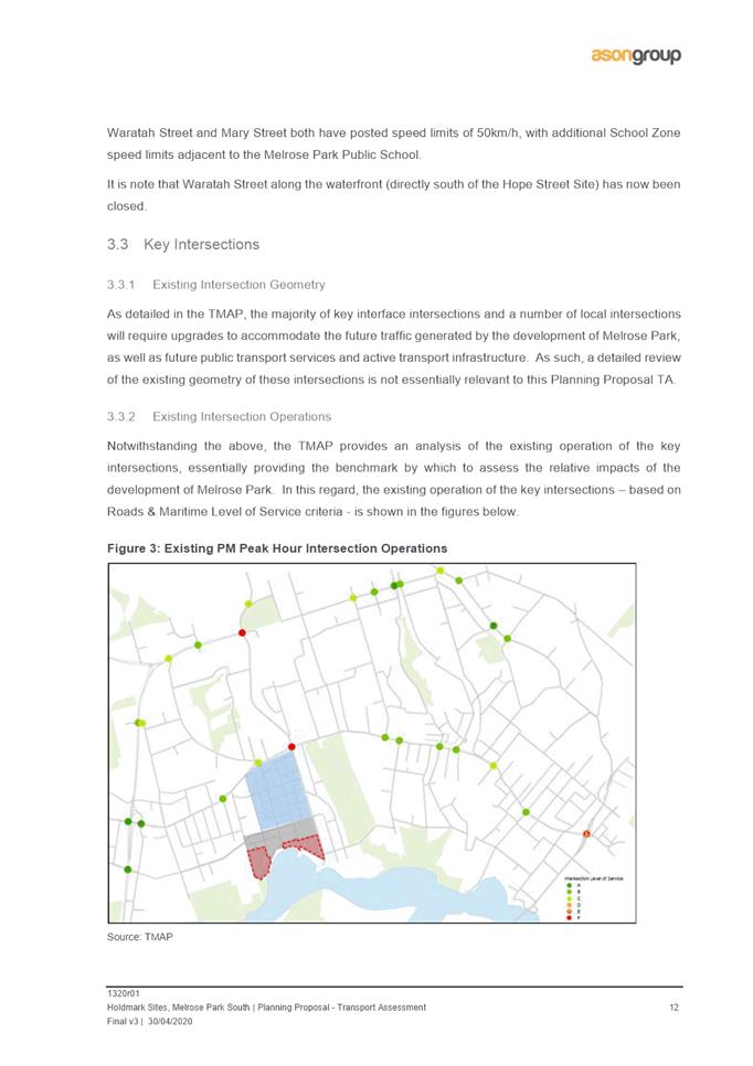
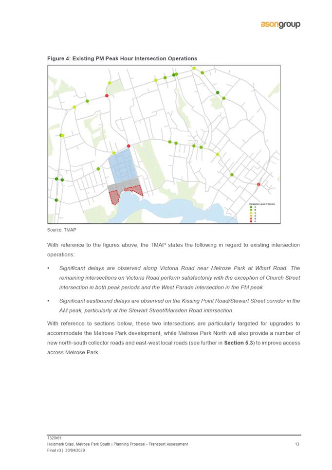
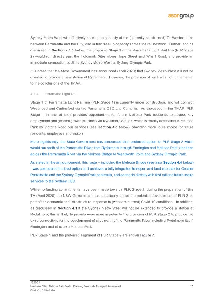
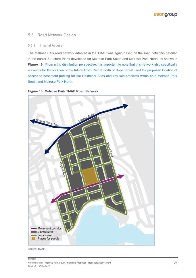
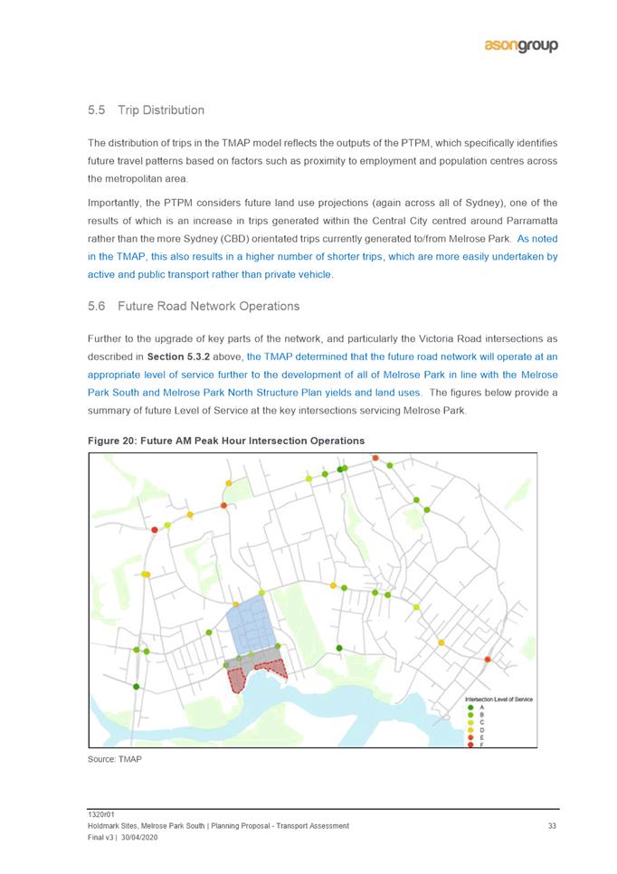
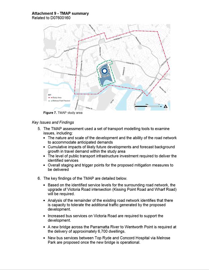
TRANSPORT MANAGEMENT AND ACCESSIBILITY PLAN (TMAP)
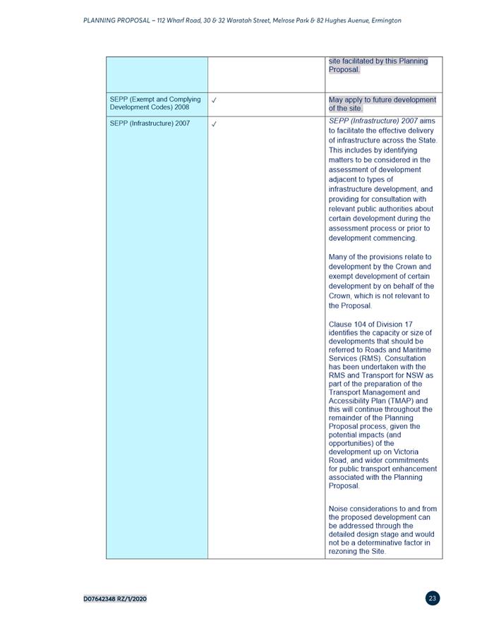
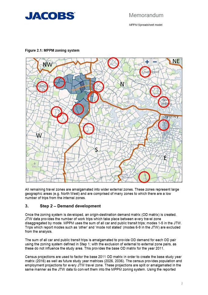
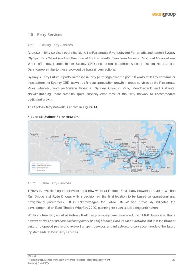
22. Traffic and transport issues were identified as a key consideration early in the planning process for the entire precinct (both north and south) and as a result, a Transport Management and Accessibility Plan (TMAP) was commissioned by key northern precinct landowners, Payce, and a reference group including stakeholders from Council State agencies (RMS, TfNSW and DPIE) and applicants from the northern (Payce) and southern (Holdmark and Goodman) precincts to monitor and provide input into the TMAP process. The preparation of the TMAP was also a condition of the Gateway determination associated with the Melrose Park North Planning Proposal and will used as a supporting technical document for all Planning Proposals within the precinct.
23. The TMAP tested an agreed FSR range from 1.6:1 and 1.85:1 across the whole Melrose Park precinct to help determine the capacity of the precinct from a traffic and transport perspective and to be used to inform the appropriate density within the Melrose Park precinct along with further urban design testing.
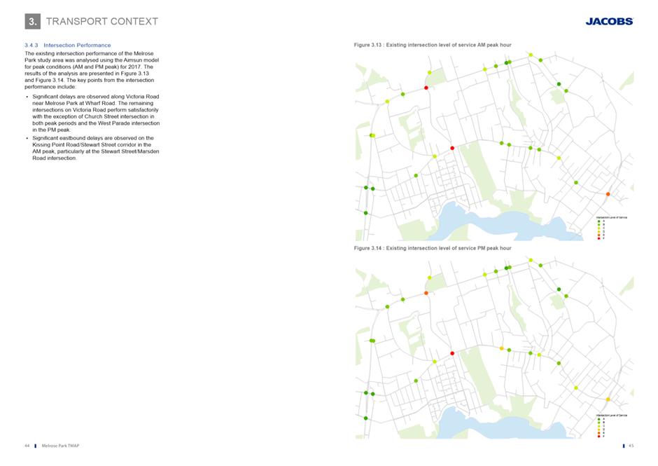
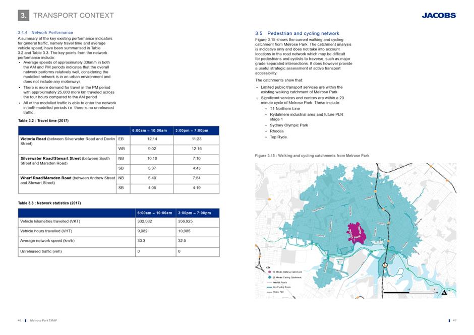
24. The TMAP was completed in late 2018 and concluded that the precinct has the capacity to accommodate up to 11,000 dwellings from a traffic and transport perspective subject to the identified road and public transport improvements and new infrastructure being delivered at the appropriate stages. The TMAP has been endorsed by TfNSW, RMS and Council for exhibition purposes and will be exhibited with the Revised Melrose Park North Planning Proposal. Prior to final endorsement, however, further investigation is required to be undertaken following the exhibition period. A summary of the TMAP’s aims, objectives and findings is provided at Attachment 9.
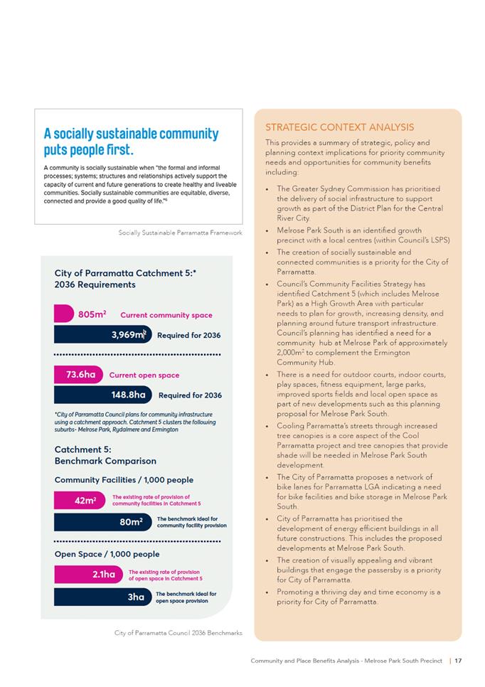
Implementation Plan A
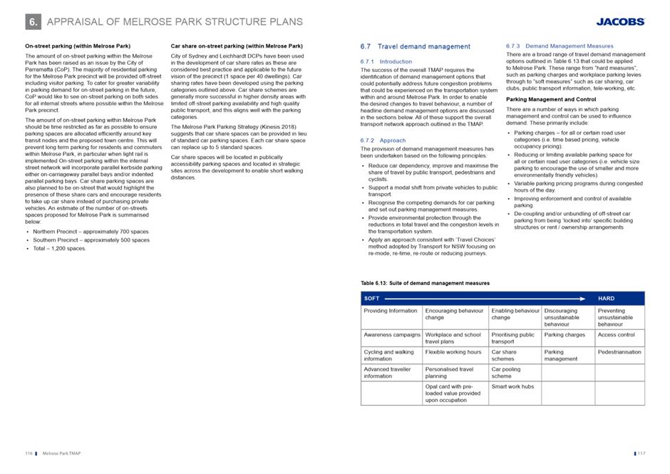
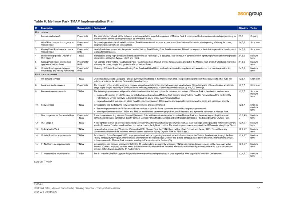
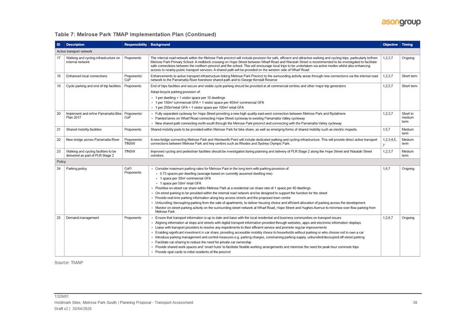
25. Based on consultation between State agencies and as noted above, Council and other key stakeholders, an Implementation Plan has been developed and included in the TMAP (refer to Table 1 )to ensure required infrastructure is delivered within and outside the precinct at the appropriate stages of development to cater for the increase in demand. The Implementation Plan included in the TMAP (Implementation Plan A) provides a framework to ensure an integrated and coordinated approach in the delivery of this infrastructure, and implementation of the measures identified in the TMAP will be undertaken by Council, State agencies and developers within the precinct at the appropriate stages.
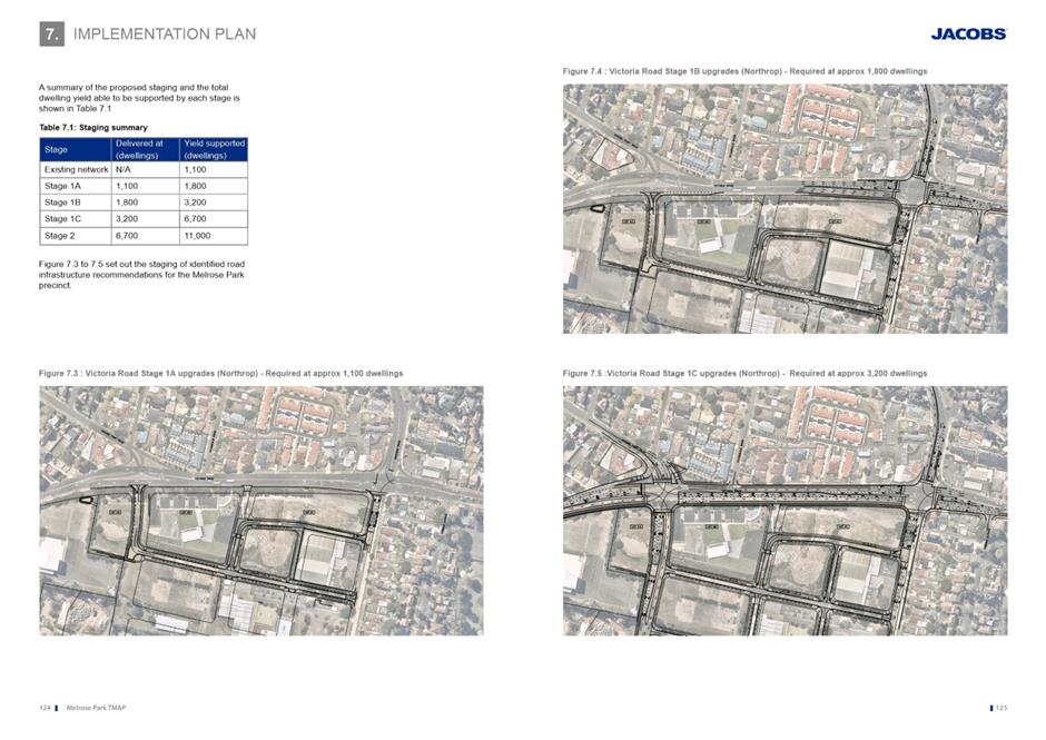
26. The redevelopment of Melrose Park is a long term undertaking and will be developed in stages. The initial stages will be based on land ownership, market demand, funding, community needs and design and requires a level of flexibility to be able to adapt to changing needs over time. A summary of the proposed staging and the total dwelling yield apportioned between the north and south precincts that is able to be supported by each stage is shown below. The detailed staging and sequencing will be further refined to ensure an appropriate apportionment is achieved between the northern and southern precincts, however Table 1 below shows the indicative overall staging with further detail on each stage included in the TMAP contained at Attachment 2.
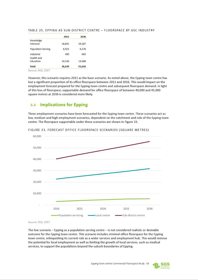
TMAP Implementation Plan A
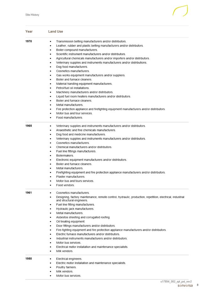
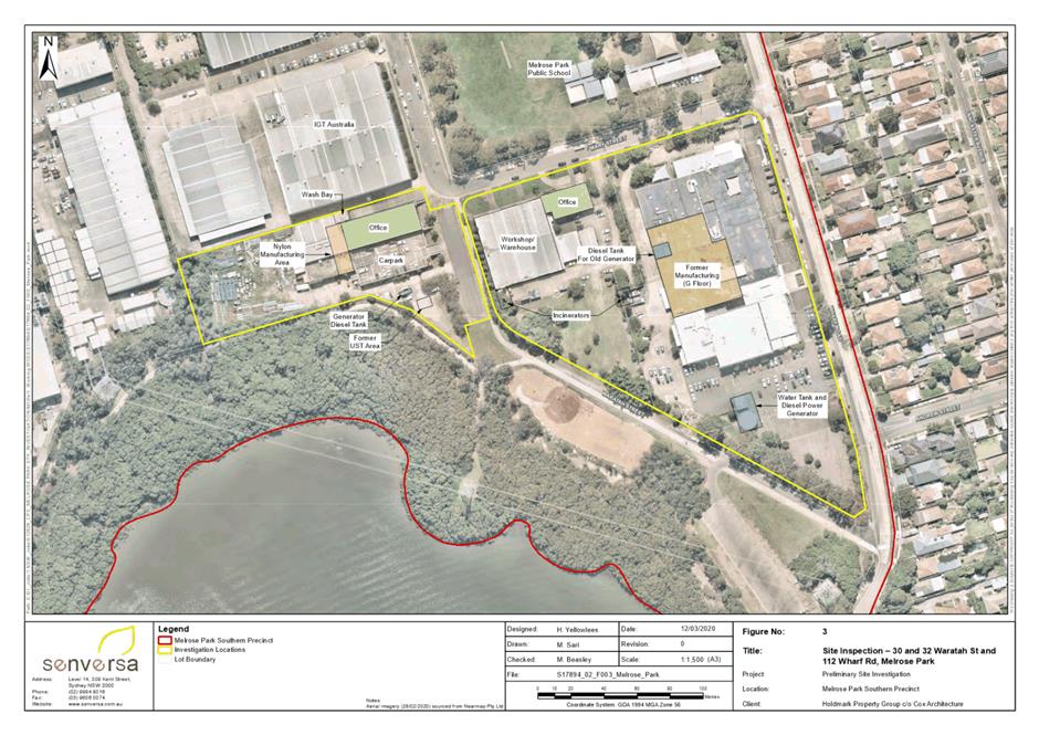
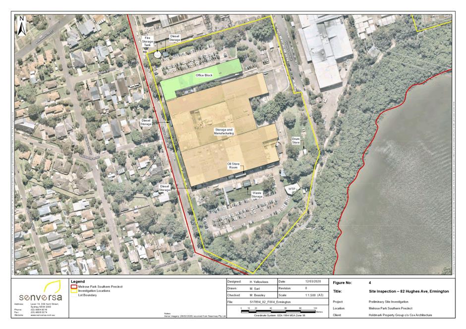
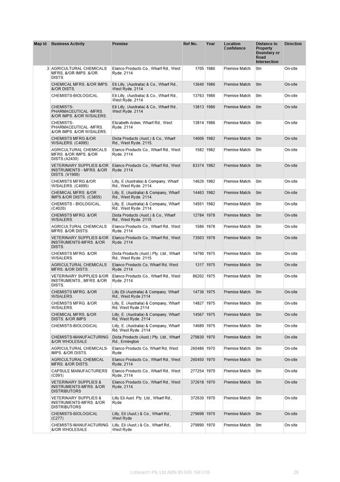
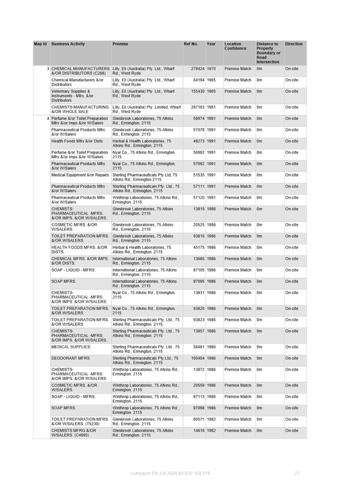
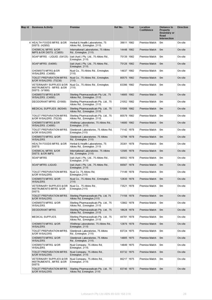
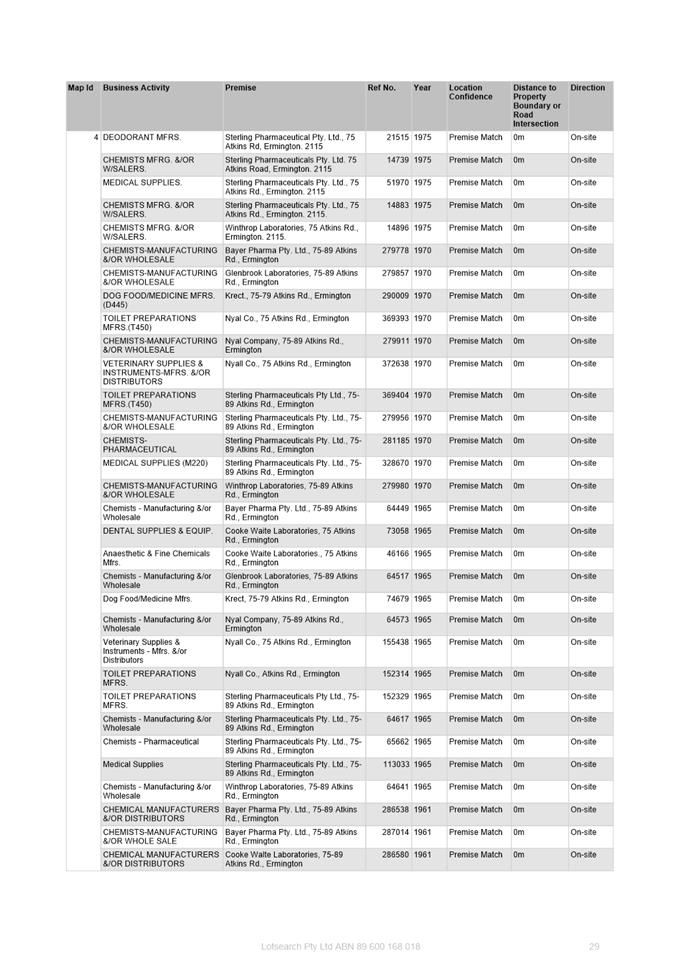
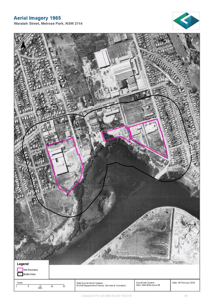
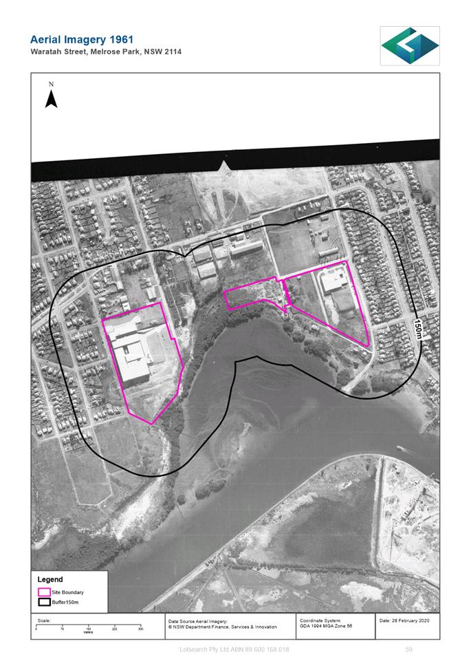
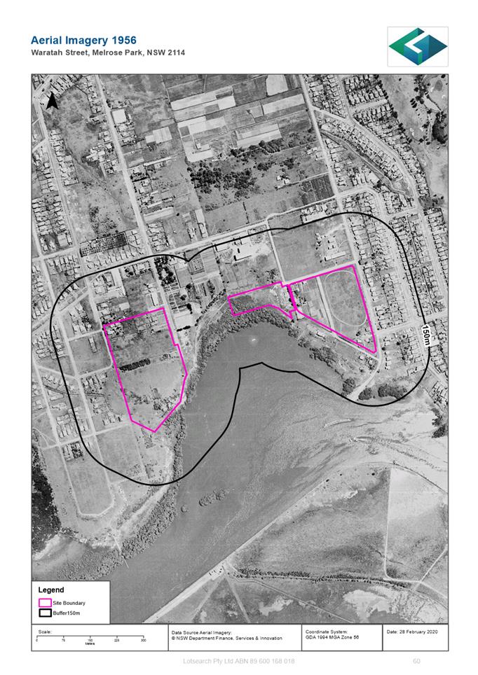
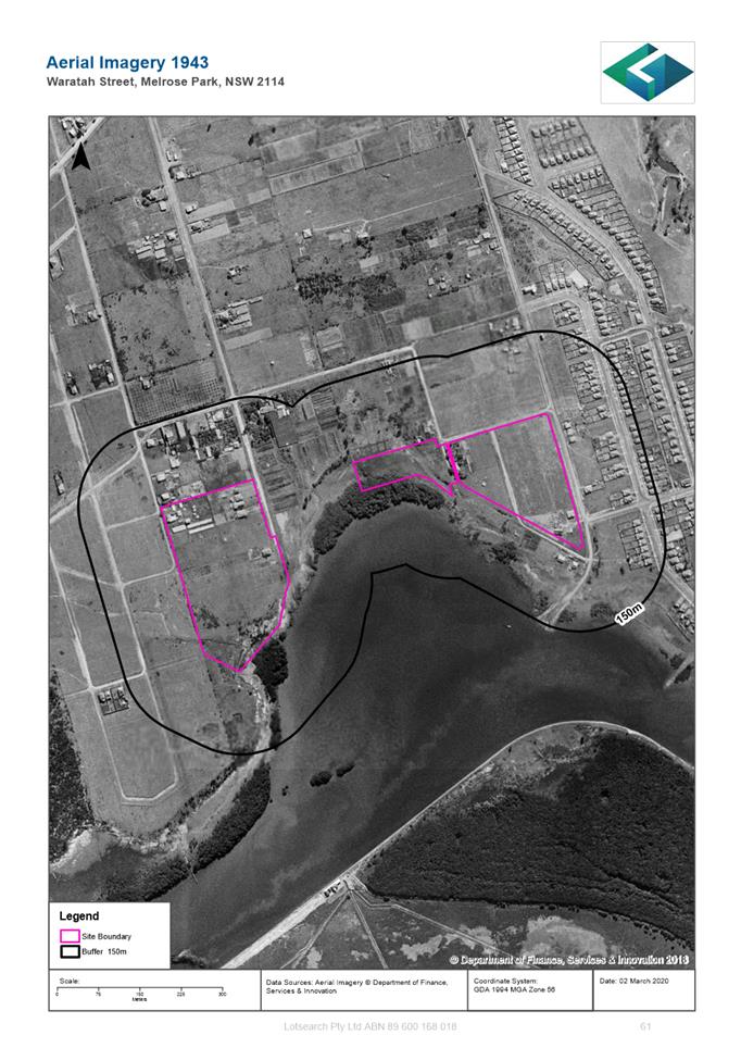
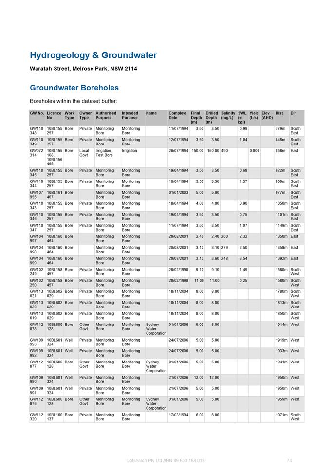
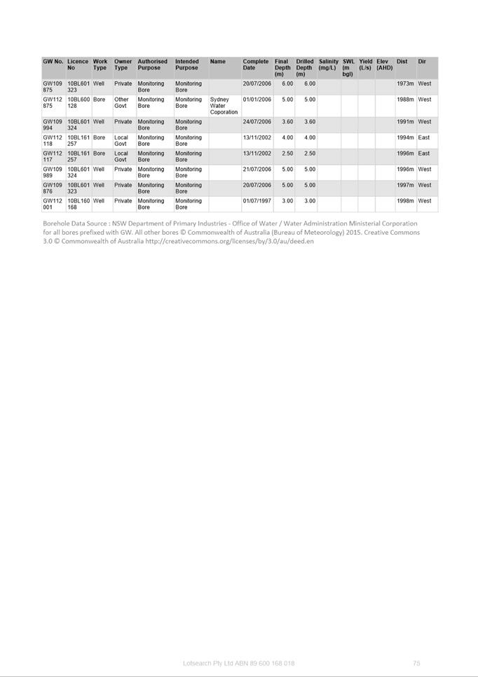
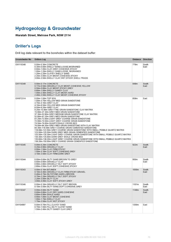
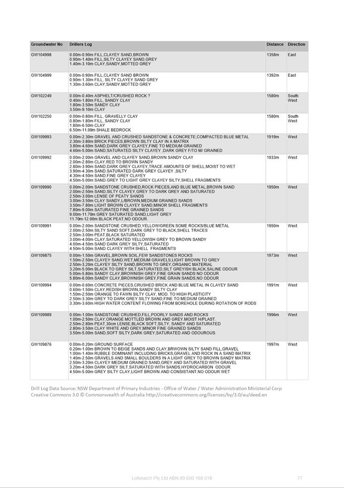
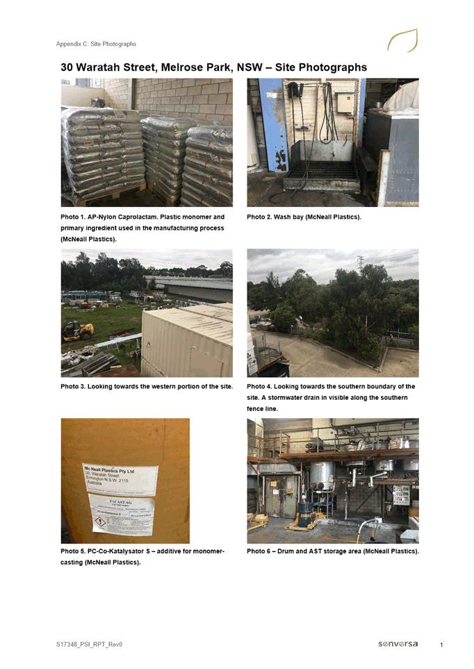
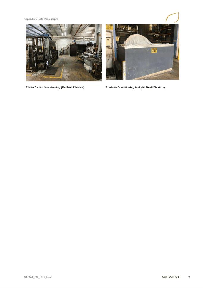
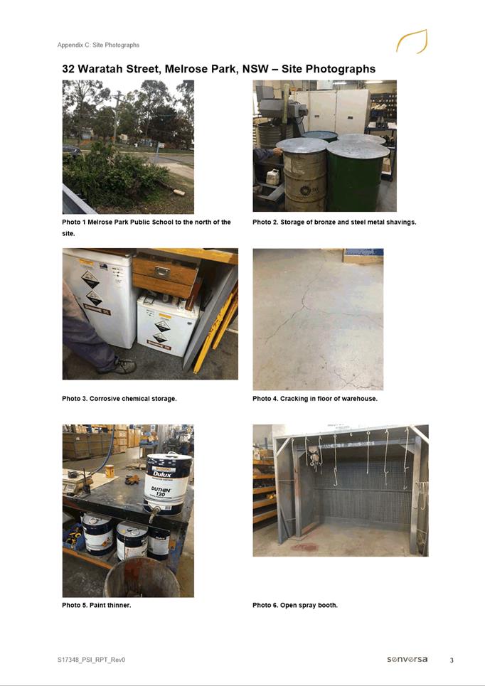
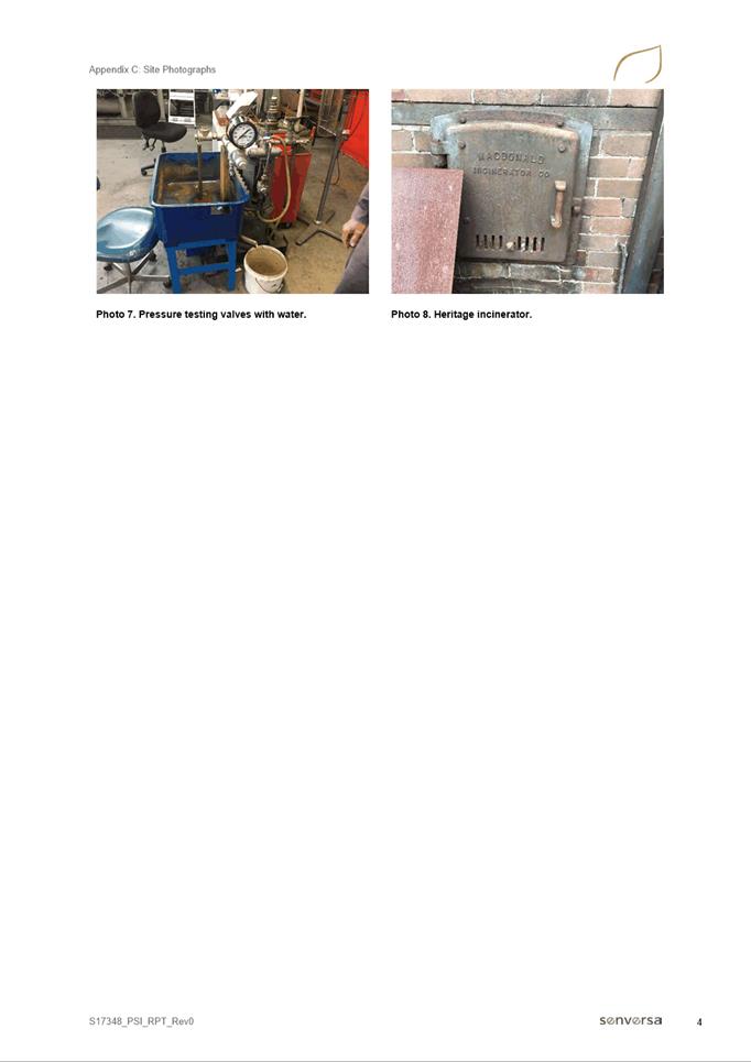
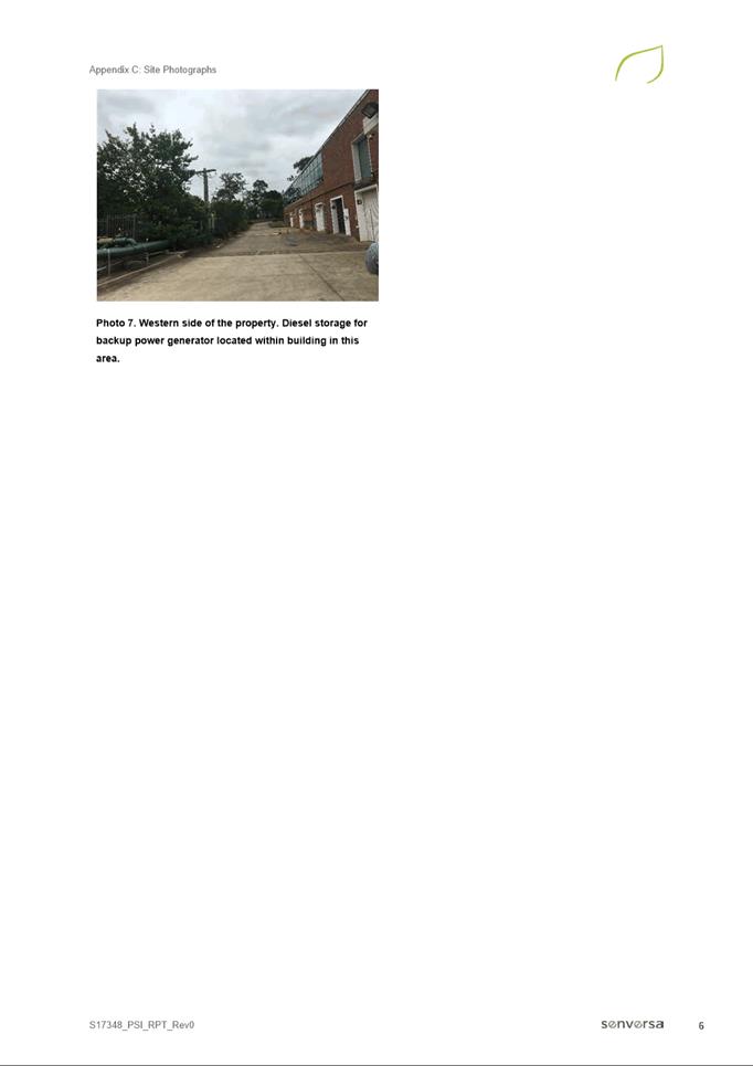
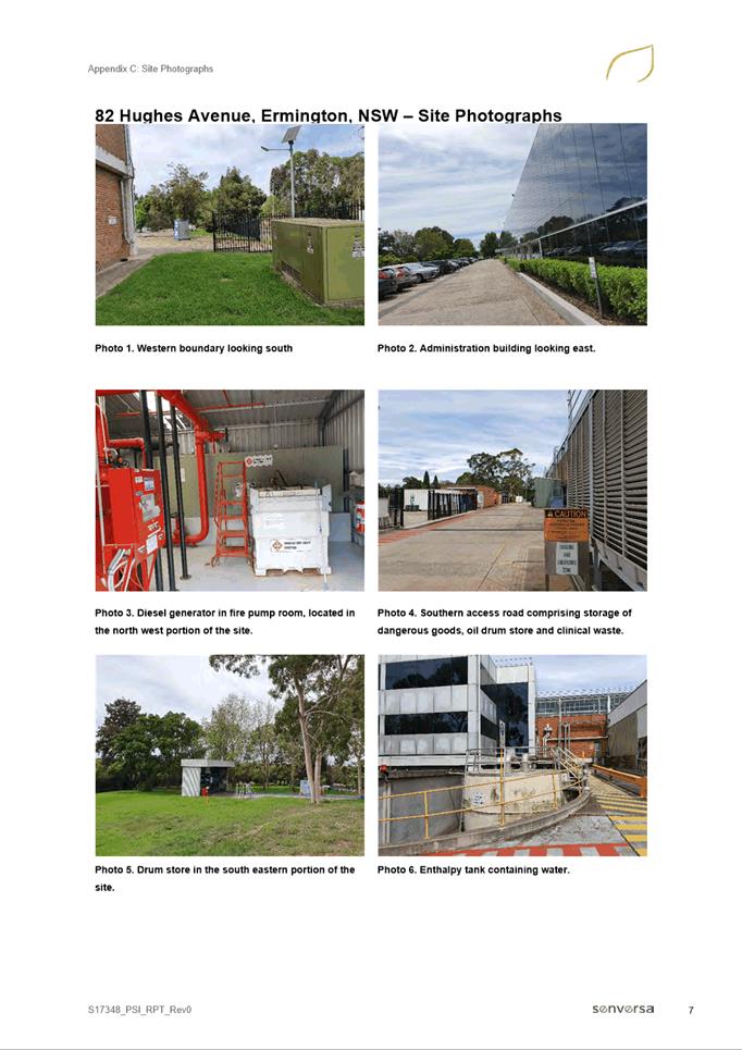
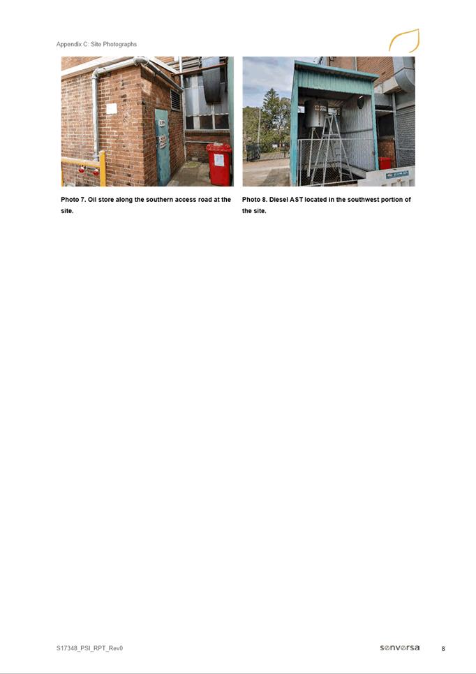
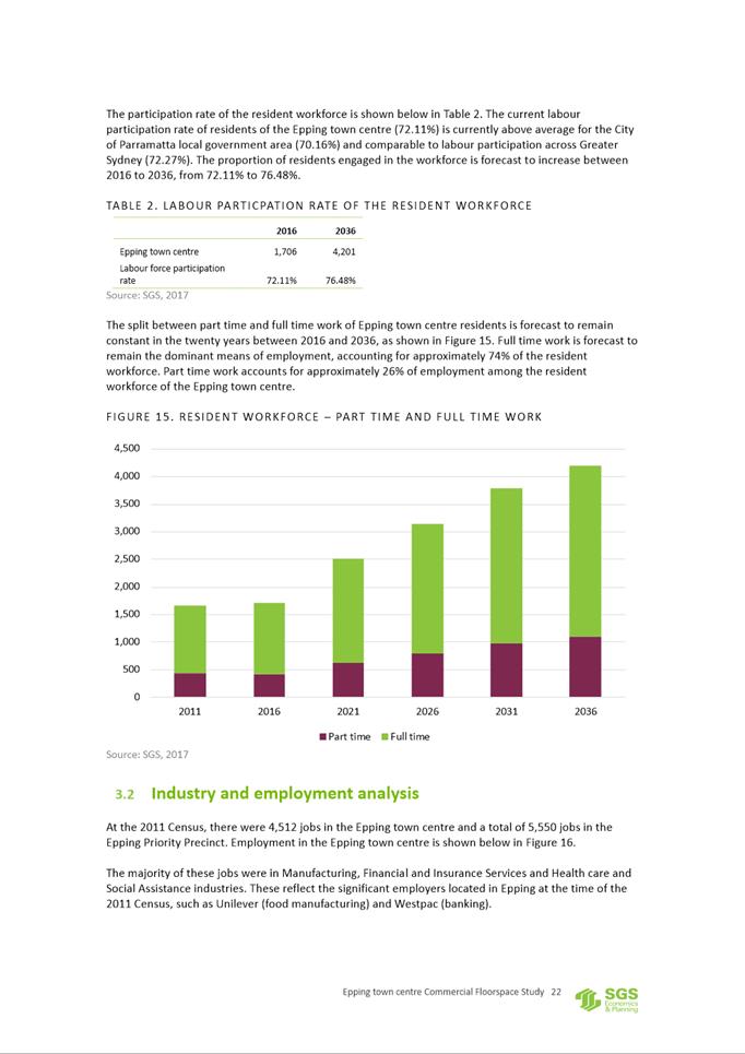
|
STAGE |
DELIVERED AT (DWELLINGS) |
YIELD SUPPORTED (DWELLINGS) |
|
Existing network |
N/A |
1,100 |
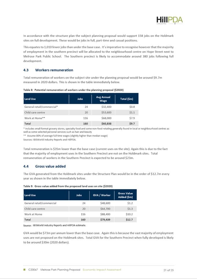
|
Stage 1A |
1,100 |
1,800 |
|
Stage 1B |
1,800 |
3,200 |
|
Stage 1C |
3,200 |
6,700 |
|
Stage 2 |
6,700 |
11,000 |
|
STAGE |
DELIVERABLE |
|
|
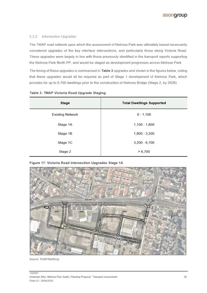
1A |
Widening of Wharf Road south of Victoria Road Left in/left out access from Victoria Road to Kissing Point Road extension |
|
|
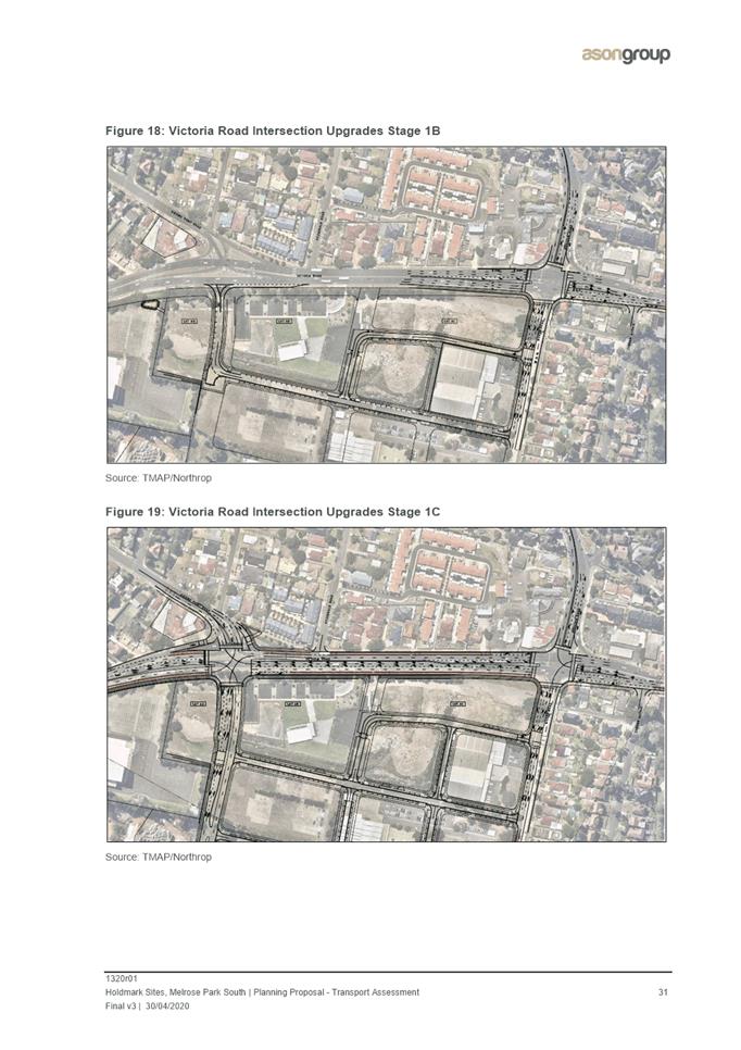
1B |
Upgrade of Victoria Road intersection to provide: Additional dedicated left turn lane on eastern Victoria Road approach 4 lanes at the stopline on Wharf Road approach (1 left, 1 through and 2 right) Removal of slip lane on western Victoria Road approach and realignment of stopline to allow a more efficient signal phasing Additional through-lane on Marsden road approach |
|
|
1C |
Upgrade of Victoria Road/Kissing Point road intersection to provide: Fully signalised intersection allowing all turning movements Dual right turn lanes on the eastern and western Victoria Road approach Dual right turn lanes and a shared left/through lane on the southern Kissing Point Road approach 4 lanes at the stopline on the northern Kissing Point Road approach (1 right, 2 through and 1 left) New signalised pedestrian crossings on the northern, southern and western intersection legs There is the potential to provide an indented bus bay for eastbound services on Victoria Road directly east of the upgraded Kissing Point Road intersection. Further investigation is required. |
|
|
Throughout Stage 1 |
Commencing with one bus, provide shuttle buses between Melrose Park and Meadowbank Station. Increase as additional dwellings are delivered with a total of 4 buses at 12 shuttles per hour in peak periods. Staged increases in the frequency of the M52 service on Victoria Road. Staged delivery of the internal road network and associated pedestrian and cycling infrastructure within the precinct. |
|
|
Stage 2 |
New public and active transport bridge over the Parramatta River to Wentworth Point. The bridge will be able to cater for both bus and light rail to connect with Sydney Metro West. Maintaining improved M52 bus service along Victoria Road and providing services over the new bridge either via bus or light rail. Continued staged delivery of the internal road network and associated pedestrian and cycling infrastructure. |
|
Table 1. TMAP Indicative Implementation Plan A for the delivery of transport/traffic infrastructure
27. Implementation Plan A which addresses the delivery of infrastructure to support up to 11,000 dwellings across the precinct and notes the required transport infrastructure referred to above. It will facilitate a maximum overall FSR of 1.85:1 for the northern part of the precinct and a similar appropriate development potential in the southern precinct of a maximum overall FSR of 1.7:1. However, it is considered necessary to include an alternative Implementation Plan B which will apply to the north and south precincts should no commitment to the bridge to Wentworth Point and light rail or equivalent bus service be made, noting that commitment has been made to the delivery of Sydney Metro West. The development scenario under Implementation Plan B will restrict the total yield to 6,700 dwellings across the precinct and result in a 40% reduction in overall density being applied to both the north and south precincts until such time that the required transport infrastructure is committed. It is proposed that Implementation Plan B will be included in the PLEP 2011 and reinforced by the site-specific DCP and VPA in addition to the TMAP’s Implementation Plan A. The TMAP is contained in Attachment 2 and contains further detail on the methodology, assessment and recommendations. This Planning Proposal has been informed by the outcomes of the TMAP and is consistent with the maximum development scenario of up to 11,000 dwellings being provided within the precinct.
PLANNING PROPOSAL ASSESSMENT
28. The Planning Proposal seeks to amend PLEP 2011 to enable redevelopment for high density residential, public open space and some retail/commercial uses on the sites. The Planning Proposal applies to two separate sites (refer to Figure 3) within the southern precinct of Melrose Park, with the applicable current and proposed planning controls for each site identified in Table 1 below.
Table 1. Summary of current and proposed planning controls
|
|
EAST SITE |
WEST SITE |
||
|
|
112 Wharf Road |
30 Waratah Street |
32 Waratah Street |
82 Hughes Avenue |
|
Current Zone |
IN1 General Industrial |
|||
|
Proposed Zone |
Part R4 High Density Residential, part RE1 Public Recreation |
RE1 Public Recreation |
Part R4 High Density Residential, part RE1 Public Recreation |
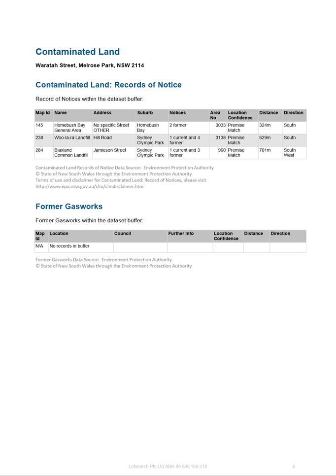
Part R4 High Density Residential, part RE1 Public Recreation |
|
Current FSR |
1:1 |
1:1 |
||
|
Proposed FSR |
1.66:1 |
1.78:1 |
||
|
Current height limit |
12m |
12m |
||
|
Proposed Height limit |
Ranging from 8 storeys (34m), 12 storeys (45m) and 22 storeys (77m) |
|||
|
Potential dwelling yield per site |
835 units |
1,090 units |
||
|
Total potential dwelling yield |
1,925 |
|||
|
Non-residential floor space component |
500m2 |
500m2 |
||
29. These two sites comprise of approximately 9.4ha of the 19ha southern precinct, which equates to approximately 49% of the land area under Holdmark’s ownership.
Strategic Planning Context
30. The Planning Proposal has been prepared in accordance with the Environmental Planning and Assessment Act 1979 (EP&A Act) and the NSW DPIE’s A Guide to Preparing Planning Proposals and considers the State and local planning strategies and is consistent with Council’s adopted Local Strategic Planning Statement, Employment Lands Strategy and Local Housing Strategy.
Local Strategic Planning Statement
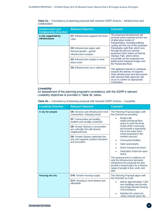
31. Council’s adopted Local Strategic Planning Statement (LSPS) provides strategic direction on how the City of Parramatta is planning for the next 20 years and draws together the needs and aspirations of the community and identifies priorities for jobs, home and infrastructure. The LSPS contains actions and priorities to help Parramatta achieve the vision of the State Government’s Greater Sydney Region Plan and Central City District Plan and highlights its important role as the Central River City. In addition to being identified as a Growth Precinct in the LHS, the LSPS identifies it as a proposed Local Centre and one which could provide for over 2,000 jobs once fully redeveloped. The LSPS also identifies the need for improved public transport and demonstrates its important through Planning Priority 3 which relates Council’s policy directions on improving connectivity to the Parramatta CBD and surrounding district through staging of development in alignment with delivery of PLR Stage 2 (or equivalent) and Sydney Metro West. As Melrose Park is identified as a Growth Precinct and the Proposal will help delivery the housing and infrastructure needed, it aligns with the vision of the LSPS.
Employment Lands Strategy
32. The Planning Proposal is consistent with both the adopted Employment Lands Strategy (2016) and Employment Lands Strategy – Review and Update (2020) which identifies the industrial lands within Melrose Park as a Structure Plan area and being suitable for redevelopment for non-industrial uses. This is due to the restructuring of the pharmaceutical manufacturing industry, which has a strong presence in the precinct, and has resulted in a number of companies relocating to other larger and more accessible industrial precinct in Sydney or offshore. This has left behind large, purpose built buildings that aren’t able to be easily converted to other uses. In addition, the precinct is no longer considered suitable as an industrial precinct as it is not located close to any major transport corridors and is surrounded by residential development.
Local Housing Strategy
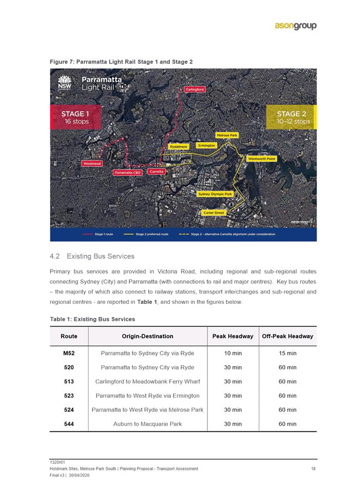
33. The Planning Proposal is consistent with the City of Parramatta Local Housing Strategy (LHS), which provides direction at the local level about when are where future housing growth will occur and how it aligns with the broader NSW-government strategic planning framework. The LHS identifies Melrose Park as a Growth Precinct and forecasts that approximately 6,330 new dwellings will occupy the precinct by 2036. The LHS also highlights the importance of ensuring that infrastructure delivery is aligned with housing growth and that growth precincts need to be aligned and effectively sequenced with State-driven transport delivery and to ensure targeted local infrastructure programs. The Proposal is consistent with this approach in that it is located within the announced Parramatta Light Rail (PLR) Stage 2 corridor and the TMAP for the precinct includes a staging plan for the delivery of the necessary road upgrades and public transport to support the future population of the precinct.
34. Full details of this assessment are contained within Part 3 of the Planning Proposal at Attachment 1.
35. While the Melrose Park precinct is centrally located, it does not benefit from factors that allow it to continue to operate successfully as an industrial precinct in the long term. These factors include having direct access to major arterial corridors, the ability to operate in a conflict-free environment with a sufficient buffer from residential uses, critical mass of land to enable large scale clustering of business activities, tenant diversity to minimise vacancy risk and generic buildings that can be easily re-purposed for other uses. Following the relatively recent departure of a number of large pharmaceutical businesses from the precinct, the potential benefits of redevelopment within the precinct in accordance with the ELS are more apparent.
Land Use Planning Assessment
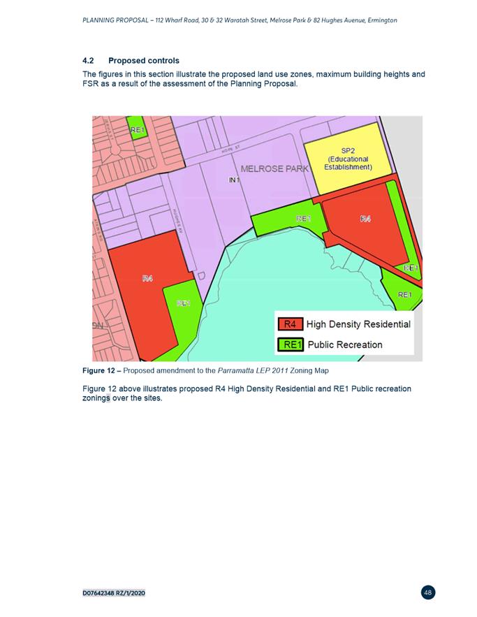
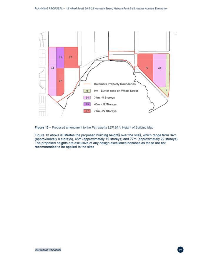
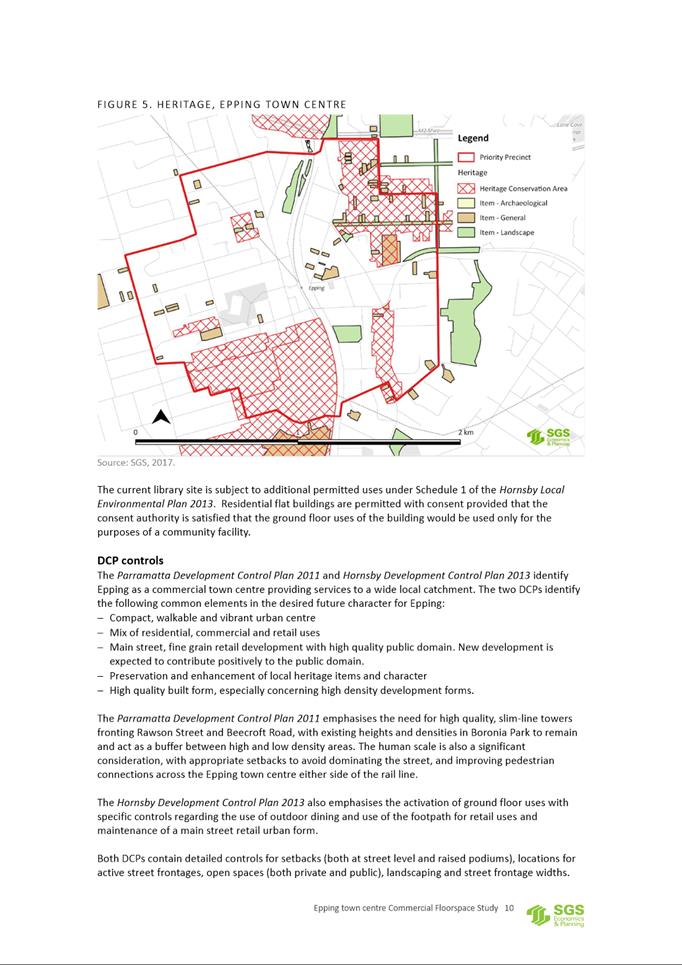
36. This Planning Proposal has been prepared using the adopted Southern Structure Plan to inform the proposed built form and densities on the sites. The proposed land uses zones and land uses on the site are considered appropriate and consistent with the recommendation of the ELS in that the sites have been identified as being suitable for redevelopment for non-industrial uses. Refer to Figures 8, 9 and 10 for the proposed zones, FSRs and building heights on the sites.
Figure 8. Proposed land use zones on the sites
Figure 9. Proposed FSRs on the sites
 Figure 10. Proposed maximum height of
buildings on the sites
Figure 10. Proposed maximum height of
buildings on the sites
37. In order to ensure that the overall density in the southern precinct is contained and that the overall gross FSR does not exceed 1.7:1, the Southern Structure Plan identifies specific FSRs and maximum building heights for each developable lot (refer to Table 1 above). The lots that are subject to this Planning Proposal and their allocated FSR and maximum building heights as identified in the Southern Structure Plan are identified in Table 2 below.
Table 2. Southern Structure Plan allocated building heights and net FSR for lots subject to the Planning Proposal.
|
|
|
FSR (gross) |
FSR (net) |
Maximum Height |
|
East Site |
Lot 12 |
1.66:1 |
3.4:1 |
64m (approx. 20 storeys |
| Lot 13 | 2.2:1 |
26m (approx. 8 storeys) |
||
| Lot 14 | 3.6:1 |
26m |
||
|
West Site |
Lot 3 |
1.79:1 |
2.3:1 |
20m (approx. 6 storeys) |
| Lot 5 | 3.8:1 |
58m (approx. 18 storeys) |
||
| Lot 16 | 3.9:1 |
58m |
38. The Planning Proposal seeks to amend Schedule 1 Additional Permitted Uses of PLEP 2011 to permit ‘food and drink premises’ in the R4 High Density Residential zone. The intention of this amendment is to enable street-level activation by allowing restaurants and cafes to operate on the ground floor of buildings located on the East and West sites along the waterfront of Parramatta River. Council officers raise no objection to this and relevant controls will be included in the site-specific DCP to address amenity.
39. The Planning Proposal was referred to a number of sections within Council for assessment against the requirements of the adopted structure plan, with the key matters for consideration detailed below.
Urban Design
40. It is considered that the proposal is consistent with the structure plan requirements for these sites with the exception of the proposed building heights, where some variation is proposed. The Planning Proposal is seeking a significant increase in density on the sites compared to the current uses and therefore ensuring an appropriate design outcome is achieved is imperative.
41. Although the structure plan identifies an indicative built form for each development lot that demonstrates that the proposed densities can be achieved, there is an element of flexibility incorporated into a structure plan by nature to enable the best outcome can be delivered as a result of more detailed design work.
42. The key issue of the proposal relates to the proposed building heights of the of the towers located within the East and West sites as these are proposed to increase from the maximum 20 storeys identified in Southern Structure Plan to 22 storeys on the East site and 18 storeys to 22 storeys on the West site. However, the tower locations remain on the inner part of the site to maximise the distance between existing low density residential development on the eastern side of Wharf Road and western side of Atkins Road and achieves a better outcome in relation to building amenity and design on the remainder of the sites. As a result, it is considered an acceptable variation by Council officers.
43. A comparison of the building heights identified in the structure plan and the proposed revised heights is provided in Table 3 below.
Table 3. Comparison of structure plan and proposed revised building heights
|
|
|
FSR (gross) |
Maximum Height (Structure Plan) |
Revised Height |
|
East Site |
Lot 12 |
1.66:1 |
64m (approx. 20 storeys |
77m (approx. 22 storeys |
| Lot 13 | 26m (approx. 8 storeys) |
28m (approx. 8 storeys. Allows for higher floor to ceiling heights on the first two levels, site topography and lift overrun) |
||
| Lot 14 | 26m | |||
| West Site |
Lot 3 |
1.79:1 |
20m (approx. 6 storeys) |
Part 28m (approx. 8 storeys & part 77m (approx. 22 storeys |
| Lot 5 | 58m (approx. 18 storeys) |
77m (approx. 22 storeys |
||
| Lot 16 | 58m |
Part 28m (approx. 8 storeys. Allows for higher floor to ceiling heights on the first two levels, site topography and lift overrun) and part 77m (approx. 22 storeys) |
44. These increases in heights are considered to be acceptable as it will:
· allow greater internal building separation on each lot and therefore provide a more usable and livable courtyard to be accommodated on each lot
· enable an appropriate building depth to be achieved
· enable appropriate deep soil areas on the sites for the planting of large canopy trees
· enable the provision of through-site pedestrian links
· provide the required view corridors from existing streets.
45. The tower elements will be limited to being located on the inner lots of each site and the perimeter lots will maintain the 6-8 storey limit as identified in the structure plan. This will to ensure that an appropriate transition is provided between the new development and existing low density development on the opposite side of both Wharf Road and Atkins Road.
46. The revised heights will also produce a better design outcome for each building on the lots and ensure that the required sight lines from Andrew Street through the East site can be maintained and that views to the river are maximised from each building. Refer to Figures 11 and 12 for the revised indicative schemes for the East and West sites showing the proposed building heights and locations of towers and heights.
Figure 11. Revised East site scheme
Figure 12. Revised West site scheme
Design Excellence
47. The applicant has indicated a willingness to incorporate design excellence provisions into the planning controls for the proposal, which is supported by Council officers due to the scale of the proposed development within the precinct. It is therefore recommended that a design excellence clause be introduced into PLEP 2011 requiring a design competition process to be undertaken on development lots where buildings exceeding 55m are proposed. This approach will ensure a high standard in architectural, urban and landscape design is achieved. As this proposal is not related to a single site and the proposed density is considered sufficient, it is recommended that no height and FSR bonuses be awarded on these sites due to concerns relating to the cumulative impacts on the overall density of the precinct.
48. This approach is consistent with the already adopted draft design excellence provisions within the Melrose Park North precinct as endorsed by Council on 12 August 2019. It should however be noted that the design excellence provisions within the Melrose Park North precinct are still draft provisions and are yet to be publicly exhibited or formally incorporated into any planning controls. However, it is intended that the same approach be applied to both North and South precincts to ensure consistency and equity between precincts. Any design competition would be undertaken in accordance with the City of Parramatta’s Design Excellence Competition Guidelines.
Density Control
Implementation Plan B
49. The TMAP includes an Implementation Plan A which provides up to 11,000 dwellings over the north and south precincts subject to identified road and traffic works, the bridge to Wentworth Point with light rail or equivalent bus service and Sydney West Metro being delivered. Implementation Plan A will facilitate an FSR 1.85:1 for the northern part of the precinct and 1.7:1 in the southern precinct. However, an Implementation Plan B is proposed to be included in the LEP to address the capacity of the precinct in the event that no commitment has been made by the State Government towards the bridge to Wentworth Point and associated light rail or bus service at the time of development applications being lodged in the precinct (noting that commitment has been made to the delivery of Sydney Metro West).
50. As a result, the dwelling number will be restricted to 6,700 as this is the upper limit that can be accommodated across the entire precinct without Sydney West Metro, the bridge to Wentworth Point and associated light rail or bus service being provided as identified in the TMAP. Accordingly, a 40% reduction in yield will be applied to development in Melrose Park to ensure both north and south precincts are treated equitably. Should a commitment to the bridge to Wentworth Point and associated light rail or bus service be made after this time then development to the full 11,000 dwellings can be achieved. Further discussion between Council officers and the DPIE is required regarding the best mechanism for the inclusion of this restriction in the PLEP, site specific DCP and VPA and further details will be reported to Council separately post-exhibition of the Planning Proposal.
Traffic and Transport
51. The applicant has undertaken a Traffic and Transport Assessment prepared by Ason Group (refer to Attachment 3). This assessment complements the TMAP by analysing the potential site-specific traffic implications should the redevelopment proceed and providing recommendations to resolve any identified issues, whereas the TMAP has a broader study area that assesses the potential implications at a catchment level.
52. The Planning Proposal was referred to Council’s Development and Traffic Services section for comment and raises no concerns were raised regarding the proposed densities on the sites from a traffic generation perspective given the proposed FSRs are consistent with the adopted Southern Structure Plan and the densities tested by the TMAP.
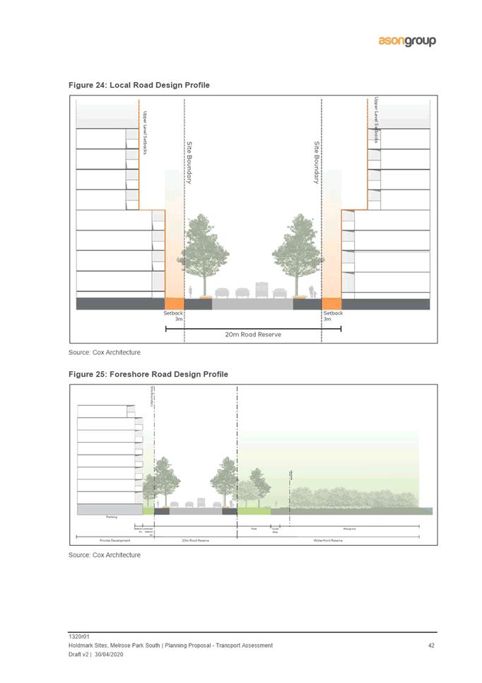
53. As part of the redevelopment, alterations to the access roads are proposed that are generally consistent with the adopted Southern Structure Plan. The proposed new roads are labelled and identified in blue in Figure 13 below. This includes facilitating the extension of Mary Street through to Atkins Road to create a foreshore connection, the reopening of Waratah Street to link to Wharf Road (subject to Parramatta Light Rail Stage 2 requirements), a new north-south park side road on the West site and new local streets on both the East and West sites to provide development frontages (see Figure 1). Council officers raise no concerns relating to the proposed access roads, however it is recommended that the intersection of Hughes Avenue and the new foreshore road be designed to enable adequate sight lines for vehicles exiting Hughes Avenue onto the foreshore road. It is considered that this can be addressed as part of the site-specific DCP and future development assessment process and does not prevent the Planning Proposal from progressing.
54. However, Council officers do not support the parking rates proposed in the Planning Proposal. It is acknowledged that these rates are consistent with those included in the TMAP, however, these have not been endorsed by Council officers. This is due the significant difference between the short term and medium/long term rates identified in the TMAP which for the short term, specify 1 car space per studio, 1 bedroom and 2 bedroom units and 1.2 spaces for 3+ bedroom units. For medium-long term, it specifies 0 spaces for studio units, 0.3 spaces for 1 bedroom units, 0.7 spaces per 2 bedroom units and 1 space per 3+ bedroom units. The lack of clarity as to when the shift between these rates is triggered. As a result, it is recommended that the parking rates detailed in Parramatta DCP 2011 for residential flat buildings be used which is consistent with the parking rates being applied in the northern precinct. This matter will be addressed as part of the site-specific DCP for the southern precinct and does not prevent the Planning Proposal from progressing.
55. The Planning Proposal was referred to Council’s Transport Planning section who raise no significant concerns upon review of the proposal and supporting Transport Assessment prepared by ASON. The applicant has provided a Green Travel Plan which is supported by Council officers, however requires the incorporation of accountability measures that the applicant will need to comply with and demonstrate how they are being addressed at the development assessment stage. This matter will be further addressed as part of the drafting of the site-specific DCP.
56. It has been noted that the proposal will be required to provide bicycle parking rates and cycling infrastructure consistent with those detailed in Council’s adopted Bike Plan. It is considered that these matters can be addressed as part of the site-specific DCP.
Figure 13. Proposed new roads in the southern precinct.
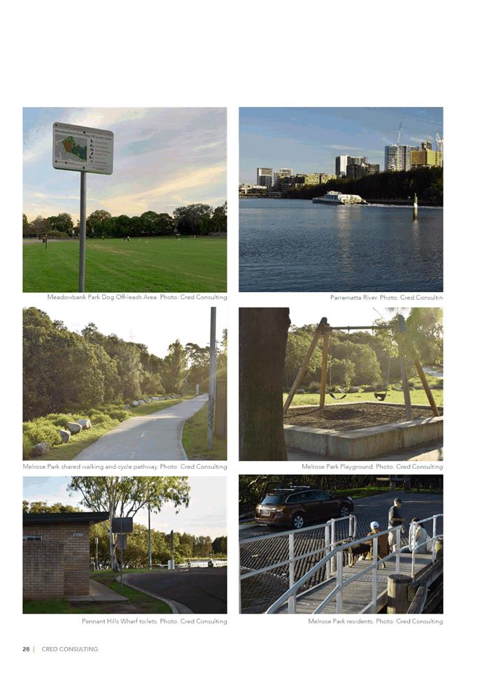
Open Space
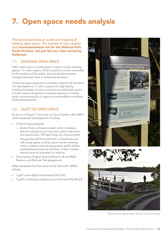
57. The applicant has provided an Ecological Assessment prepared by Eco Logical and Landscape Study prepared by Site Image (Attachment 4) to support the Planning Proposal. The proposal includes the provision of approximately 11,517m2 of new public open space within the East site and approximately 14,187m2 within the West site. This makes for a total of 25,704m2 (approximately 27% of the site) of new public open space.
58. The new public open space is proposed to be located in three key areas within the sites. Two of the key areas are proposed to be formal landscaped areas located adjacent to the foreshore area in each of the East and West sites which will provide for predominantly passive recreation uses and an appropriate buffer to the sensitive Ermington Bay wetland. The third key areas is located along Wharf Road and comprises a landscape strip up to 20m in width which will ensure that existing trees can be retained and also provide separation between the high density development on the Holdmark site and the existing low density development on the eastern side of Wharf Road within the Ryde LGA (refer to Figure 14).
Figure 14. Proposed new open space
59. The Planning Proposal has been assessed by Council’s Open Space and Recreation section against the requirements of the Southern Structure Plan regarding the provision and quality of public open space proposed to be provided on the sites. Council officers support the proposed areas of new open space, however it will need to incorporate a playground in the West and West sites, outdoor fitness equipment and a multipurpose court.
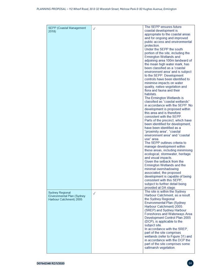
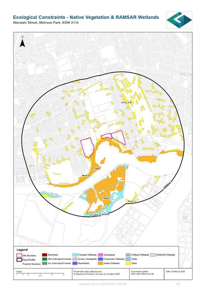
60. It is noted that the Ecological Assessment recognises the Ermington Bay wetland as having high ecological significance and requires appropriate protection to ensure it is not affected by the proposed redevelopment. This includes providing a vegetative and open space buffer of 20-30m from the edge of the wetlands to protect ecological processes and functions essential to ongoing health of the ecosystem. This buffer also ensures that the wetland will receive full solar access post-development as it is extremely sensitive to changes in microclimate .Controls to ensure the wetlands are appropriately protected will be included in the site-specific DCP that will support the Planning Proposal should it proceed.
61. Council officers raised concern that the proposed 20m wide foreshore road will encroach on the vegetated buffer and compromise its functionality. In accordance with the NSW Office of Water Guidelines for Riparian Corridors on Waterfront Land, roads are to be excluded from the open space buffer. After receiving more detailed information from the applicant regarding the road and site boundaries and mean high water mark, it is considered that the location of the road will comply with the Guidelines, however this is to be further reviewed as part of the site-specific DCP and development assessment process to ensure compliance is maintained.
62. Further detail is also required regarding the potential overshadowing of new public open space areas once the tower locations are refined. This is to be addressed as part of the site-specific DCP and as part of the development assessment process to ensure adequate sunlight is provided to public open space.
63. Concern was raised regarding the potential for bird-strikes on tower buildings. The Ermington Bat wetland provides important migratory bird habitat and there is evidence suggesting that tall buildings pose a significant danger to birds due to their reflectivity and transparency and light emissions at night. Birds perceive mirroring of the sky, trees and other features as a continuation of the habitat and can result in collisions. While important, it is considered that this matter can be addressed as part of the site-specific DCP in relation to building materials used on taller buildings especially along the foreshore. This issue is also being addressed in the formulation of planning controls for development sites within Wentworth Point.
64. In relation to the provision of open space for active recreation, this is not proposed to be provided as part of this Planning Proposal. A playing field is identified in the adopted structure plan and is proposed to be located on the site at 6 Hope Street (refer to Figure 1) and will be delivered as part of a future Planning Proposal for this site. The playing field is proposed for this location and considered suitable for the following reasons:
· It is situated wholly within one site under single ownership which enables easier delivery and the FSR to be easily redistributed across the remainder of the site;
· Its central location is easily accessible to the future residents of the precinct;
· It aligns with the core open space areas proposed in the northern precinct; and
· It is considered to enable the best urban design outcome and to be achieved from an overshadowing, passive surveillance and built form perspective.
Flooding
65. The Planning Proposal was referred to Council’s Catchment Engineer for comment, who raised no significant concerns in relation to the applicant’s proposed approach to the management of flooding and overland flow on the site. However, it is noted that management of this issue needs to be considered in conjunction with the northern precinct to ensure that both approaches are integrated and don’t result in any negative impacts on either part of the precinct. Should the overland flow from the northern precinct result in a ‘floodway’ across the southern precinct, it will need to be accommodated and not obstructed by buildings. The overland flow modelling for the northern precinct is currently being undertaken and therefore the full extent to which this may affect the southern precinct is not yet known. This will continue to be monitored and considered as this work progresses. The distribution of density within the Planning Proposal will allow refinements to the built form that will be able to accommodate changes to the future flow of water through the site. This will be re-enforced by controls within the site-specific DCP.
66. There are existing outlets along the river foreshore where storm water is currently discharged into the river, which is proposed to continue occurring once the site has been redeveloped. The management of this storm water will need to be addressed in further detailed in relation to potential environmental impacts and the mitigation of these impacts (if needed), however for the purposes of progressing the Planning Proposal it is considered that this matter can be addressed as part of the development approval process.
67. The matter of on-site detention (OSD) and incorporation of Water Sensitive Urban Design (WSUD) into both the public and private domains on the site was also raised as matters that need to be addressed in further detail to properly inform the development of the sites subject to the Planning Proposal and the Melrose Park precinct as a whole. Detailed controls to address these matters are not required to be included in an LEP amendment associated with a Planning Proposal, however these matters will be addressed in much greater detail as part of the development of the supporting DCP should the Planning Proposal progress to gateway. This is similar to the approach taken to the Melrose Park North precinct Planning Proposal that has already received gateway and is currently subject to a comprehensive DCP preparation process.
Social Outcomes
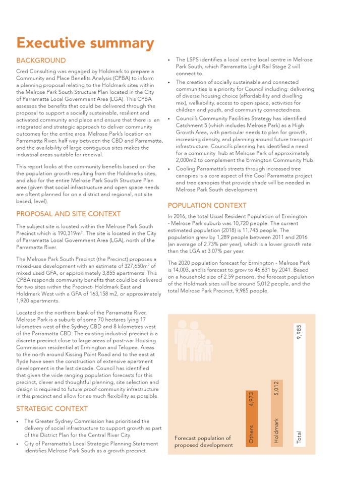
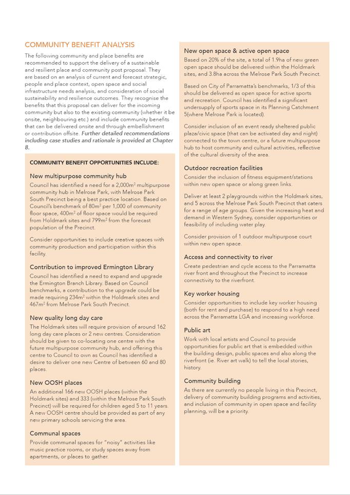
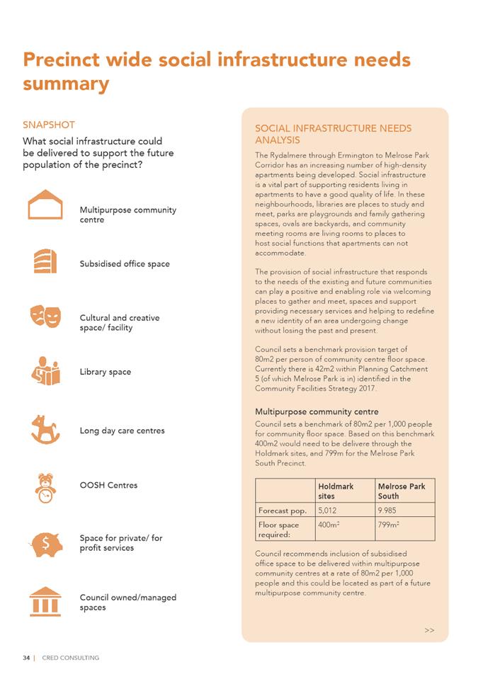
68. A Community and Place Benefits Analysis has been prepared by Cred Consulting (Attachment 5) on behalf of the applicant and provided as a supporting document to the Planning Proposal. The analysis identifies that the forecast population resulting from the redevelopment of the Holdmark sites will bring an additional 5,012 people to the southern precinct. As a result, Cred recommends the following community and place benefits be provided:
· New on-site multipurpose community hub
· Contribution towards the Ermington Community Hub
· New long day care centre- the redevelopment of the Holdmark sites will generate the need for 162 places or two new centres. One of the centres could be co-located with the multipurpose community hub and dedicated to Council.
· New Out of School Hours (OOSH) facility. The redevelopment will generate the need for 166 additional places for children ages 5 to 11 years. His facility could be incorporated into the existing or proposed education facilities in the precinct and would require discussion with School Infrastructure NSW.
· Communal spaces for activities such as music practice rooms or study areas away from apartments.
· New public open space. Approximately 20% of the developable site area is proposed to be provided as public open space.
· Outdoor recreation facilities including outdoor fitness stations, playgrounds and an outdoor multipurpose court.
· Connectivity to Parramatta River. Create pedestrian and cycle access to the Parramatta Valley Cycleway and riverfront.
· Key worker housing.
· Public Art. Explore opportunities for public art that is embedded into building design and the public domain that depicts local history.
· Community building. The delivery of community spaces in the precinct is considered a priority given no such facilities currently exist as a result of the former industrial uses on the site.
69. The applicant has expressed a willingness to discuss these items further to determine suitable locations for this infrastructure or alternatively suitable contributions for their delivery.
70. Council’s Social Outcomes section has reviewed the Planning Proposal and the Analysis and agree with the infrastructure items/public benefits identified by Cred. However, it is noted that the following matters, as identified by Cred, should be taken into consideration and given high priority for delivery to be consistent with the requirements of Council’s Community Infrastructure Strategy (CIS):
· Provision on fitness/equipment stations in the open space areas, two playgrounds and one outdoor multipurpose court.
· Confirmation of the location and proposed uses of the 400m2 of community floor space
· Further detail about the provision of a new long day care and Out of School Hours (OOSH) centre
· Further detail on the intention to provide affordable rental housing within the development
· Demonstrate opportunities for public art and delivery of community building programs and activities.
71. It is considered that the majority of these matters can be facilitated through either the site-specific DCP and/or during the development assessment process and can be agreed with the developer via a planning agreement. In relation to the provision of affordable rental housing within the development, Council officers will seek to ensure it is delivered in accordance with the requirements of Council’s Affordable Rental Housing Policy. Council officers therefore raise no significant concerns that would prevent the proposal from progressing. It is intended that a planning agreement be negotiated with the developer and exhibited concurrently with the Planning Proposal and site-specific DCP should this matter proceed.
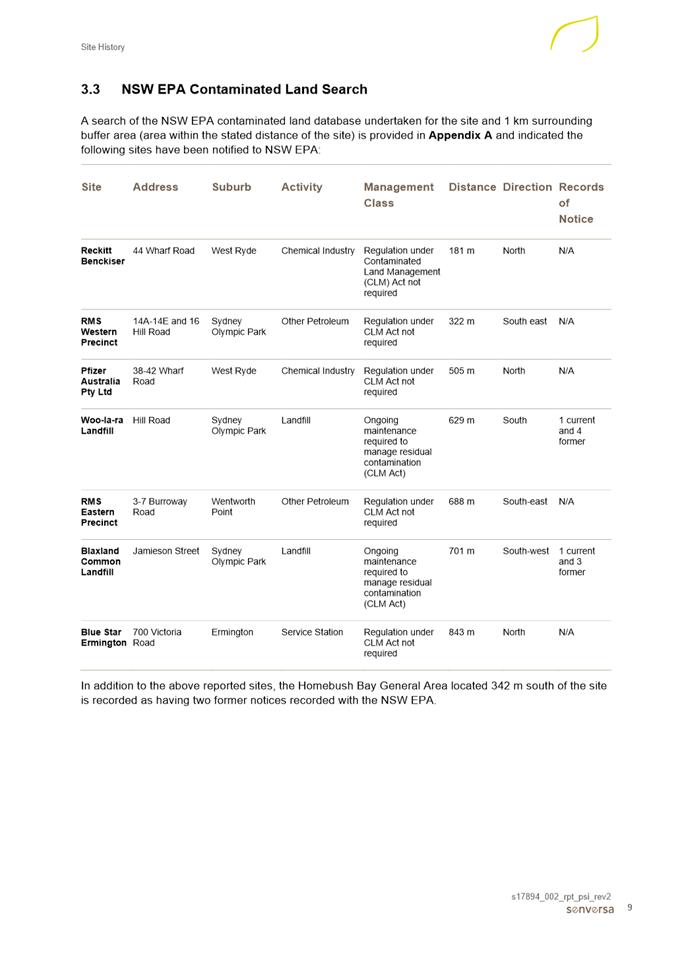
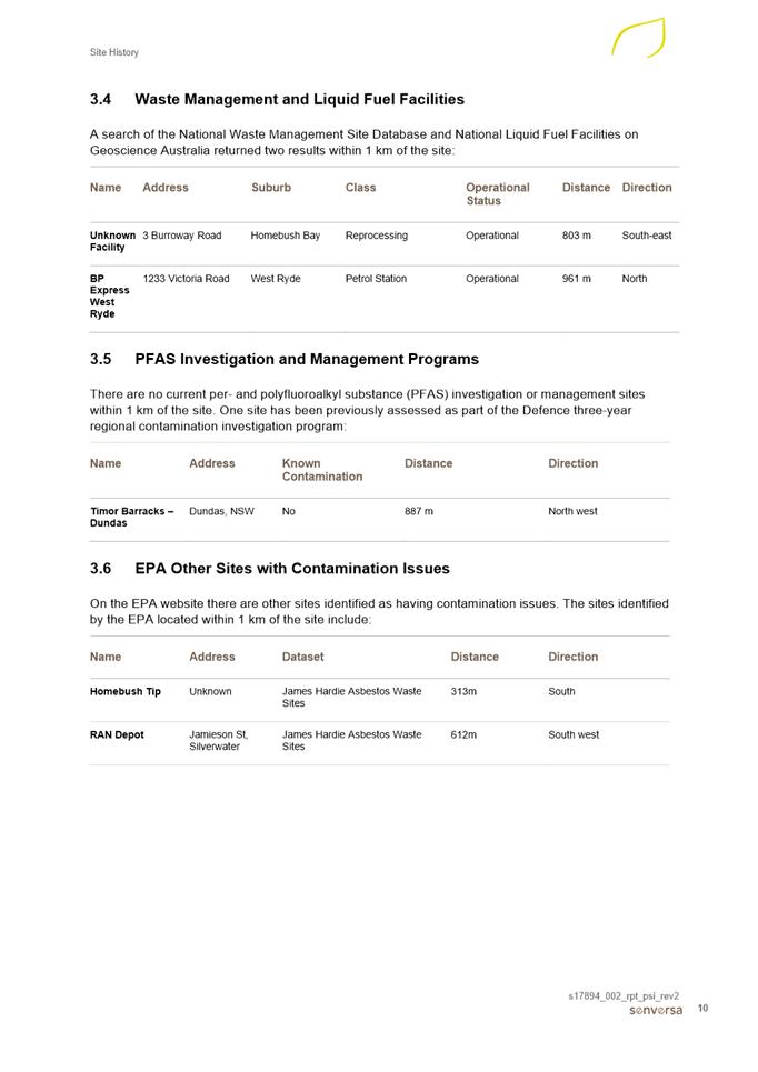
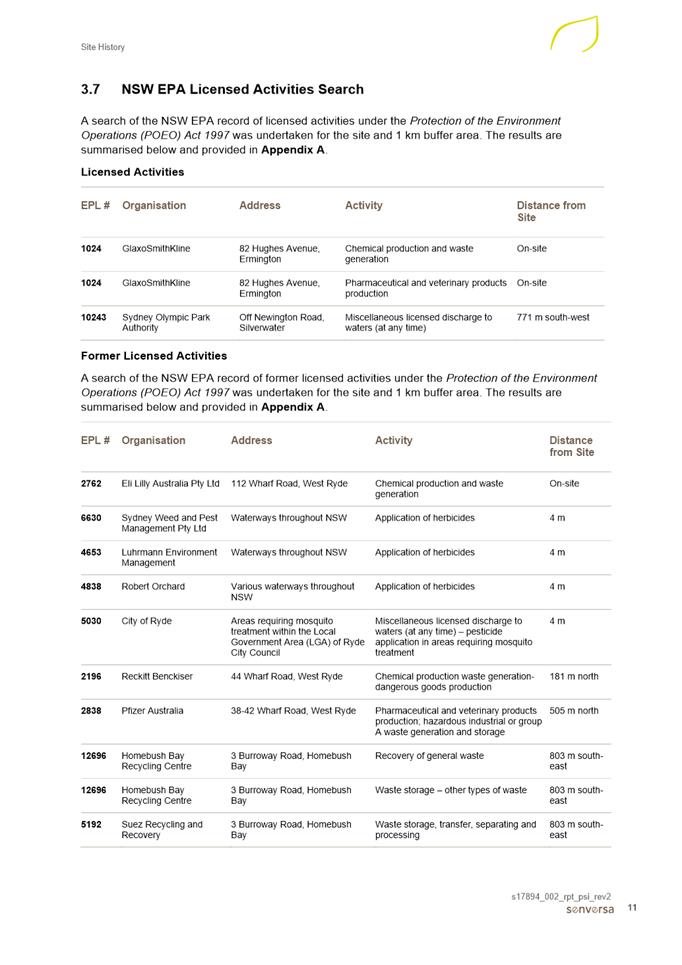
Contamination
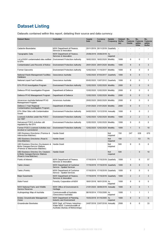
72. The land subject to this Planning Proposal is industrial land which has been occupied by a variety of uses since the 1950s, in particular those relating to pharmaceutical manufacturing. As a result, the applicant has undertaken a Preliminary Site Investigation Study (SIS) prepared by Senversa (Attachment 6) to support the Planning Proposal. The SIS identifies a number of potential contamination sources as a result of the past uses on the site, and recommends that further assessment of both sites be undertaken at the development application stage in accordance with the requirements of State Environmental Planning Policy (SEPP) 55 – Remediation of Land, Contamination Planning Guidelines. This should include:
· Extensive groundwater assessment of the West site
· A Detailed Site Investigation of the East site
· Undertake any necessary remediation of the land to ensure it is suitable for redevelopment.
73. As a result of these recommendations, the proposal was referred to Council’s Regulatory Services section for comment. It is considered that for the purposes of the Planning Proposal, no concerns are raised but that further detailed review and investigations are to undertaken during the development assessment stage in accordance with the relevant legislative requirements.
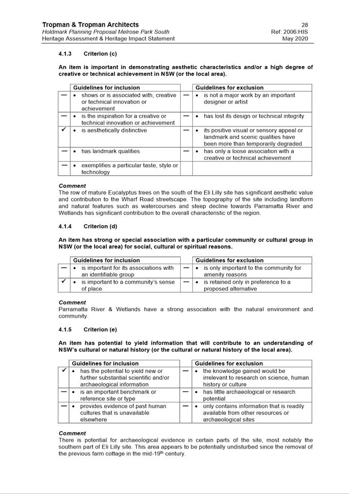
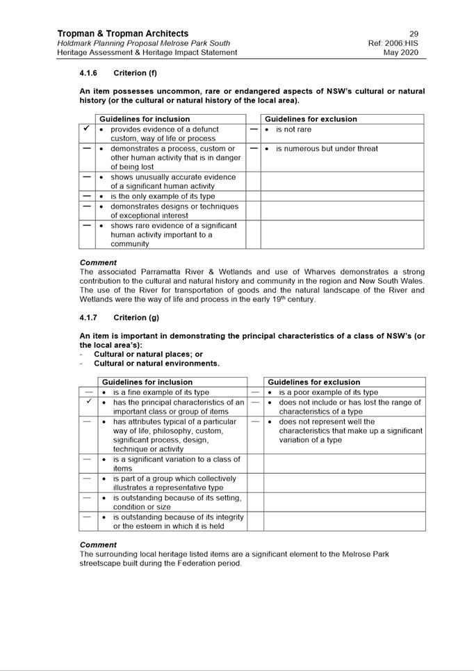
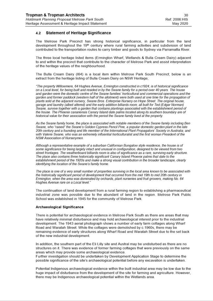
Heritage
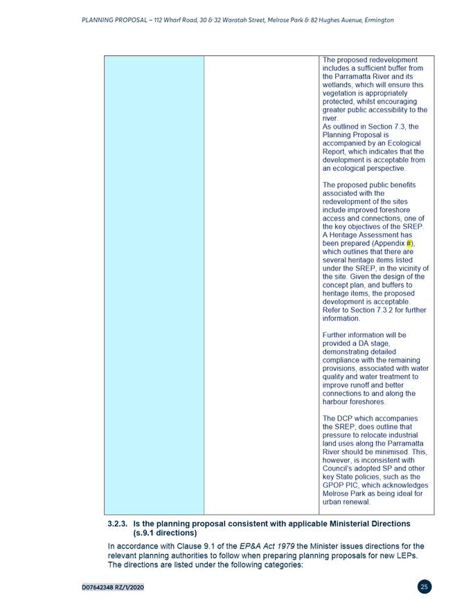
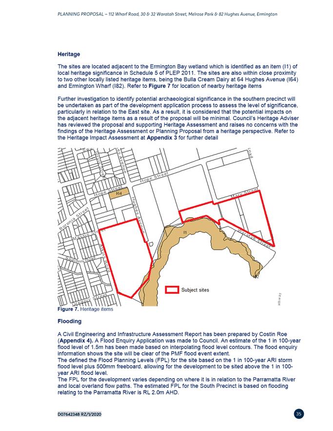
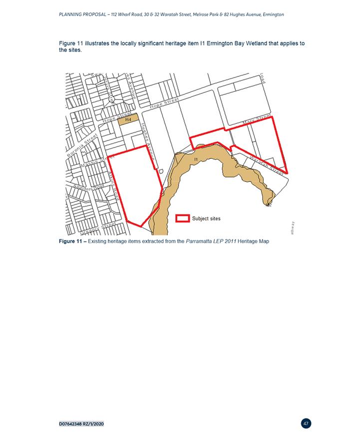
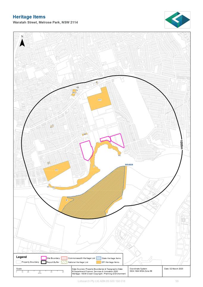
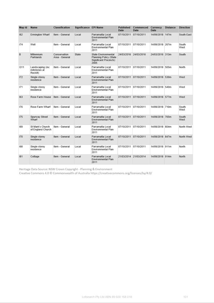
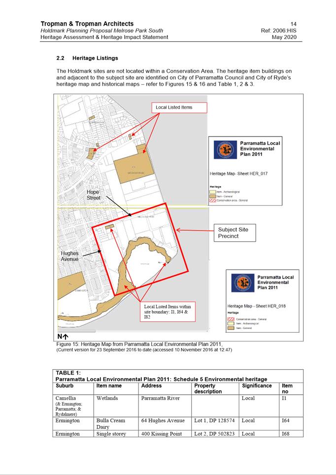
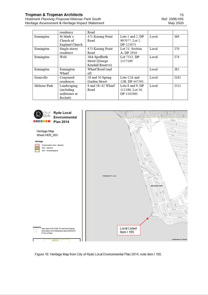
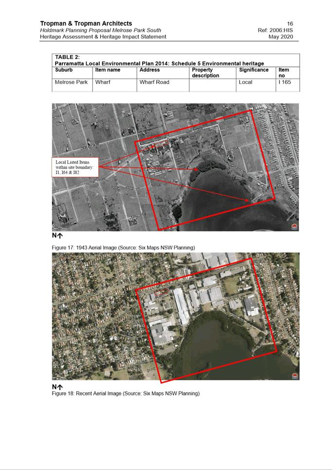
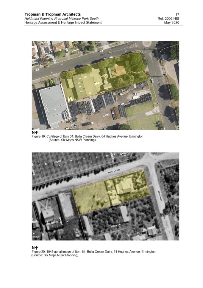
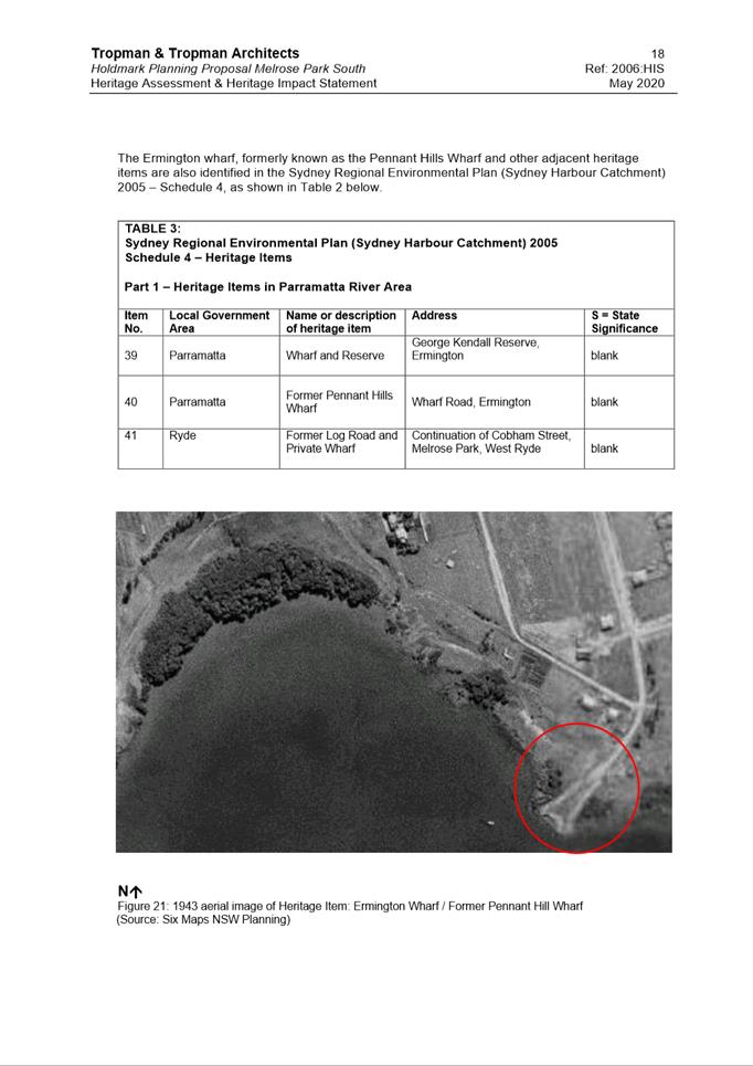
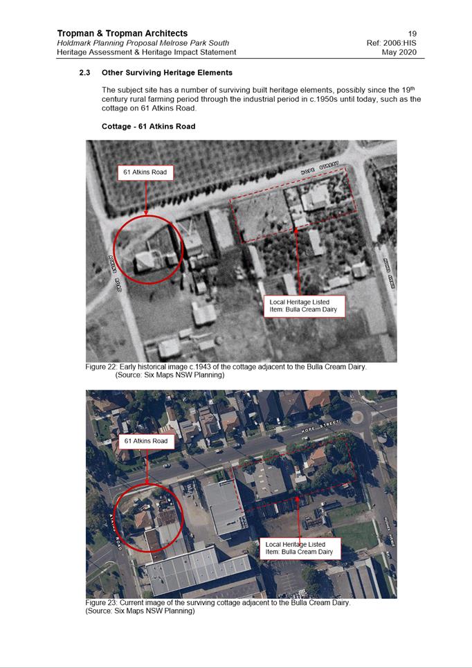
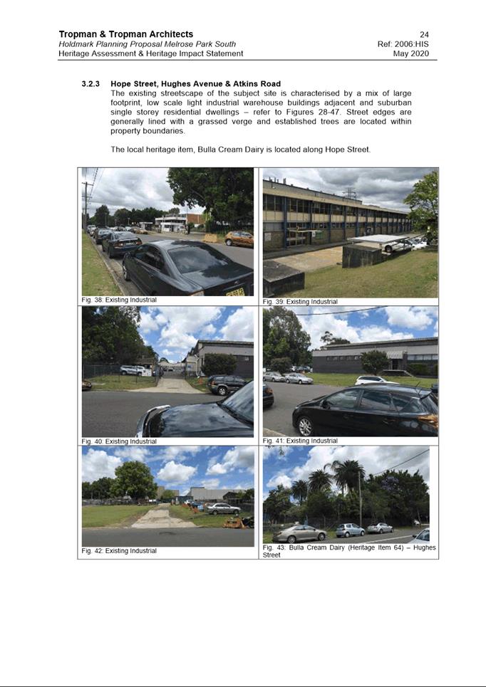
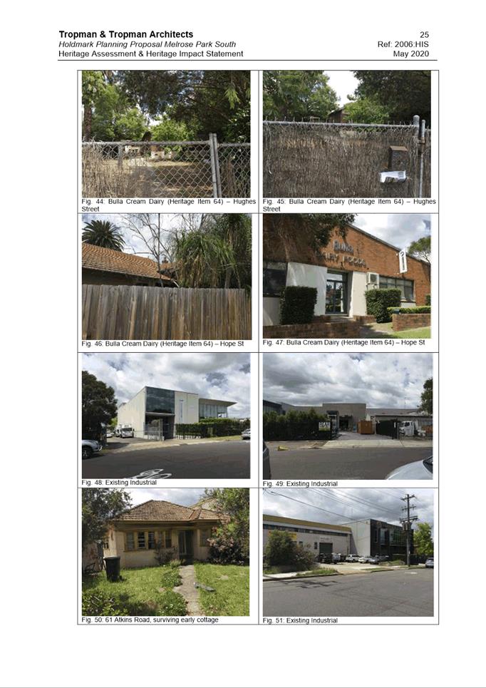
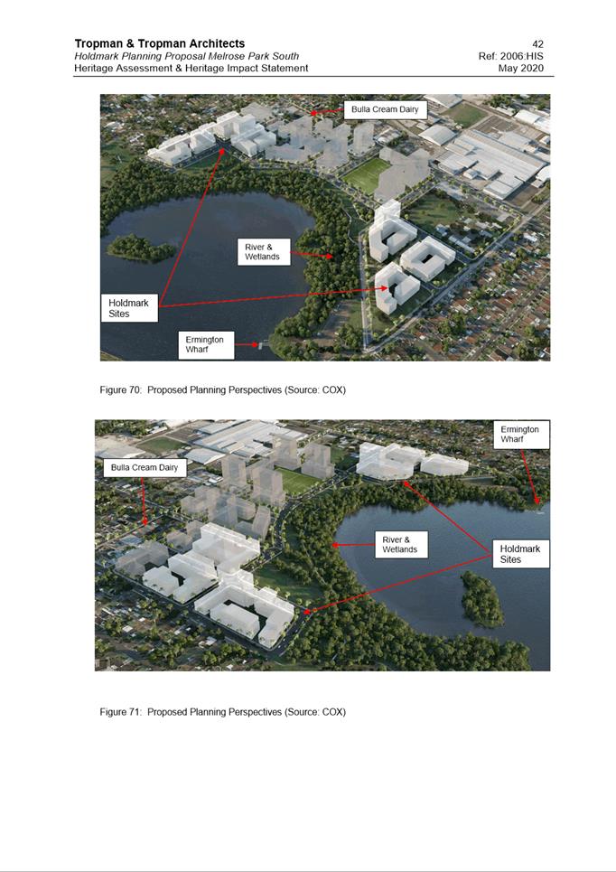
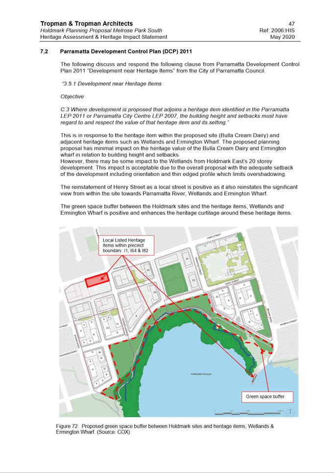
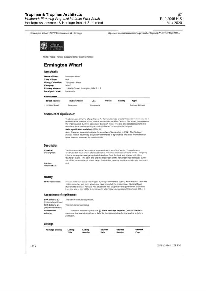
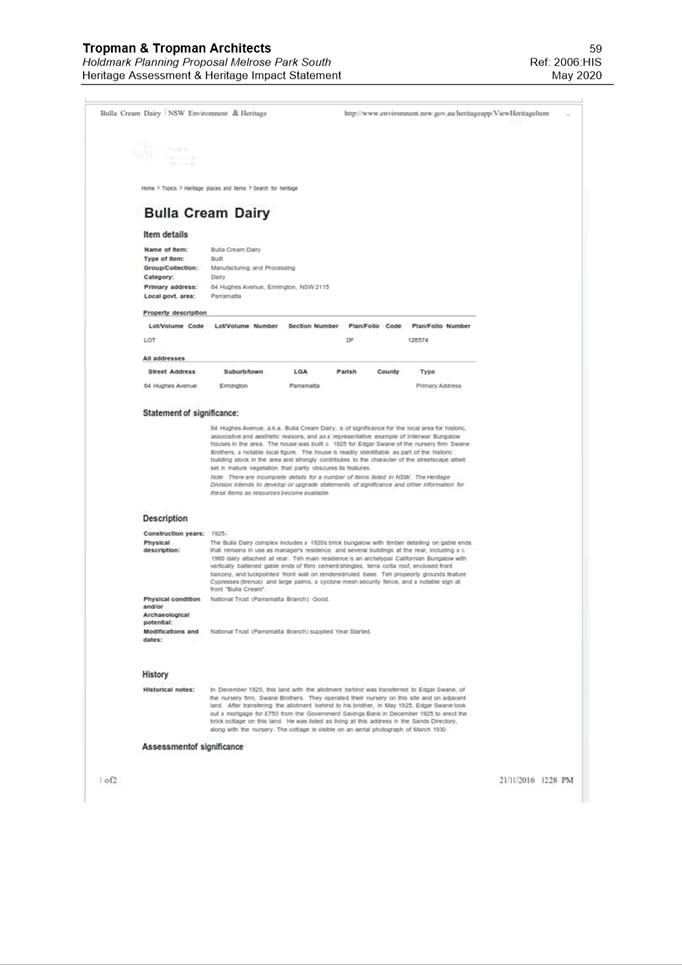
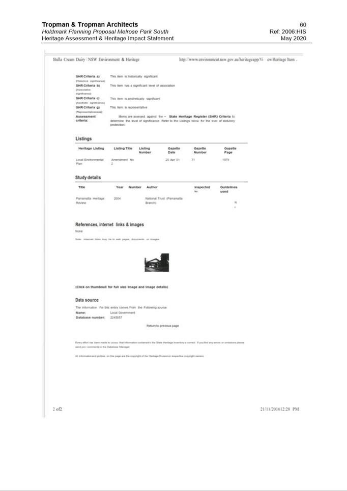
74. The sites are located adjacent to the Ermington Bay wetland which is identified as an item (I1) of local heritage significance in Schedule 5 of PLEP 2011. The sites are also within close proximity to two other locally listed heritage items, being the Bulla Cream Dairy at 64 Hughes Avenue (I64) and Ermington Wharf (I82). Refer to Figure 15 for location of nearby heritage items.
75. A Heritage Assessment has been prepared by Tropman & Tropman Architects to support the Planning Proposal (Attachment 7). The Assessment acknowledges that the proposed future development will have some visual impact to and from the adjacent heritage listed items, however these are considered to be minor and will not detract from the heritage significance or impact on the curtilage of the nearby items Ermington Bay wetland (I1) and Ermington Wharf (I82). In addition, the proposed public open space between the wetland and proposed redevelopment will provide a buffer as part of the heritage curtilage of the items.
76. Further investigation to identify potential archaeological significance in the southern precinct will be undertaken as part of the development application process to assess the level of significance, particularly in relation to the East site. As a result, it is considered that the potential impacts on the adjacent heritage items as a result of the proposal will be minimal.
77. Council’s Heritage Adviser has reviewed the proposal and supporting Heritage Assessment and raises no concerns with the findings of the Heritage Assessment or Planning Proposal from a heritage perspective.
Figure 15. Location of heritage items
Employment and Non-Residential Floor Space
78. Due to the shifting nature of the pharmaceutical manufacturing industry, many long term occupiers have relocated from the precinct, leaving a number of large, purpose-built warehouses which are difficult to tenant.
79. A key consideration in the redevelopment of the precinct as a whole is the retention of employment generating land uses to ensure a sufficient number of jobs are able to be provided on-site. A requirement of the ELS is that there be no net job loss on site as a result of redevelopment. At the time of finalising the ELS in 2016, there were approximately 2,546 employees in the precinct in total, however this has subsequently reduced as a result of further relocations of tenants. The ELS does not provide a breakdown of the number of employees in the northern and southern precincts individually. Refer to Table 4 for a comparison of employment numbers between the ELS and northern and southern precincts.
|
|
Job Number (long term) |
% of Total Jobs Compared to ELS Requirement |
|
ELS Requirement |
2,546 (as at 2016) |
- |
|
Northern Precinct |
1,538-1,932 |
60%-76% |
|
Southern Precinct (Holdmark) |
160
|
6.3%
|
|
Southern Precinct (remaining sites) |
454-848 |
18%-33% |
Table 4. Job number comparison
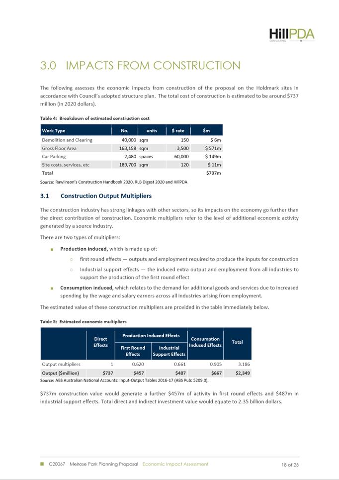
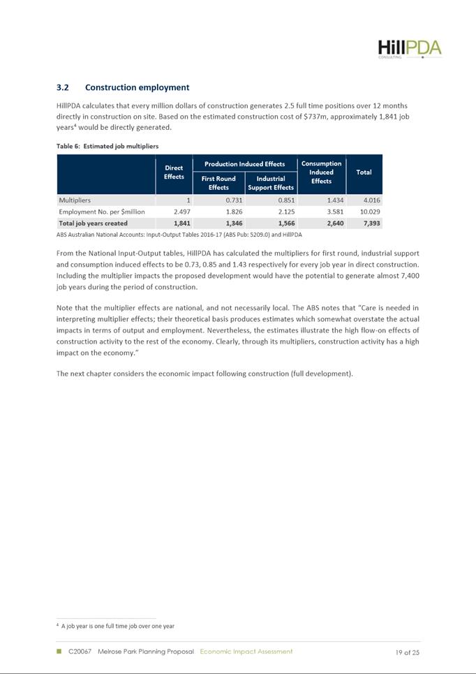
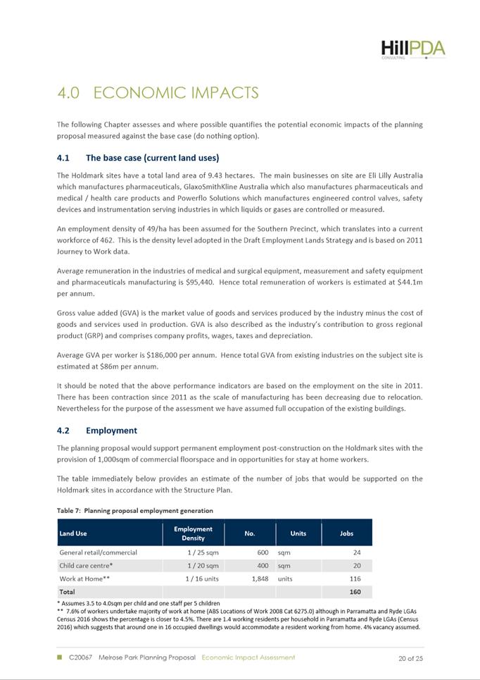
80. An Economic Impact Assessment (EIA) has been prepared by HillPDA (Attachment 8) to support the Planning Proposal that identifies a of minimum 1,000m2 of non-residential floor space be provided on site comprising 600m2 for the purposes of food and other local retail and commercial services and 400m2 for child care. According to HillPDA, this floor space would have the potential of providing approximately 160 new jobs on the site in addition to 1,841 direct construction jobs and a further 5,552 indirect jobs.
81. The EIA indicates that there will be a net loss of jobs on the Holdmark sites as a result of the redevelopment but that this needs to be assessed within the context of the broader precinct. The northern precinct is proposing to incorporate a new town centre (located on the north side of Hope Street) into the redevelopment of the Payce site in the northern precinct, which will provide 30,000m2 of non-residential floor space and generate between 1,538 to 1,932 new jobs alone and provide for the majority of the employment generating uses in the precinct. Other sites within the Southern Precinct of Melrose Park will also be required to provide non-residential floor space to meet the job requirement and are in closer proximity to the proposed town centre. Therefore, they are better positioned to provide a greater number of jobs in the Precinct. It is therefore not considered to be economically feasible for the Holdmark sites to provide additional non-residential floor space as it would potentially result in an oversupply of commercial and retail spaces and would result in a fragmented distribution of this space across the precinct. As a result of the proposed new town centre in the northern precinct, the role of the non-residential floor space in the southern precinct is proposed to be for the provision of convenience retail for local residents.
82. The provision of non-residential floor space in the southern precinct has been discussed between Council officers and the applicant and the abovementioned justification is considered to be consistent with the adopted policy position Council has taken for the overall redevelopment of Melrose Park.
DEVELOPMENT CONTROL PLAN
83. Due to the extent and scale of redevelopment proposed within the precinct, a site-specific Development Control Plan (DCP) is required to be prepared for the sites subject to the Planning Proposal.
84. The future site-specific DCP will guide development and contain specific requirements that must be addressed during the design stage of the planning process and future development application on this site, having regard to the local context and detailed design requirements for the site. These include, but are not limited to:
· Site levels
· Street and block layout
· Relationship of building to the street and block pattern
· Building typologies
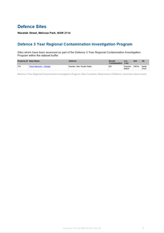
· Desired future character
· Public domain, open space and landscaping
· Site access, circulation and connectivity
· Transport and parking
· Environmental sustainability
· Storm water management
· Solar access
· Transition areas to surrounding development
85. The site-specific DCP will be prepared once the Planning Proposal has been submitted to the DPIE for Gateway determination, should Council resolve to proceed, with a draft document to be reported to Council separately prior to exhibition. The preparation of the site-specific DCP for the southern precinct is following the same drafting process as the DCP currently being prepared for the northern precinct, which commenced after the Melrose Park North Planning Proposal received Gateway determination, and it is anticipated that the two site-specific DCPs will closely resemble one another.
PLANNING AGREEMENT
86. A Planning Agreement can be made under Subdivision 2 of the EP&A Act and is a voluntary agreement between Council and the developer, under which the developer may agree to dedicate land free of cost, pay a monetary contribution or provide other material public benefit, or a combination of these, to be used towards a public purpose.
87. The Act specifies that a public purpose includes the provision of public amenities or public services, the provision of affordable housing, the provision of transport or other infrastructure relating to the land, the funding of recurrent expenditure relating to any of these, the monitoring of the planning impacts of a development and the conservation or enhancement of the natural environment.
88. Council has an adopted Planning Agreement Policy (2018) which sets out the principles governing such agreements, matters that Council will consider in negotiating agreements, steps in the negotiating process, public probity, notification requirements and implementation. The EP&A Act and Regulation sets out the legal and procedural framework for planning agreements.
89. Key principles of Council’s policy are that:
· planning decisions will not be bought or sold through planning agreements,
· development that is unacceptable on planning grounds will not be permitted because of the benefits of a planning agreement,
· the benefits of the planning agreement will bear a relationship to the application,
· Council will not give undue weight to a planning agreement when making a decision on a development application, and
· Council will not improperly rely on its position in order to extract unreasonable public benefits under planning agreements.
90. Council officers are developing an Infrastructure Needs List (INL) to ensure the infrastructure needs of the entire precinct are provided and are sufficient to service the incoming population associated with the new development. This list includes items identified in Council’s Community Infrastructure Strategy and Development Contributions Works Schedule and is to be used to inform all planning agreement negotiations associated with Planning Proposals for land within the precinct. Although the list includes infrastructure that has been identified as required within the precinct, an element of flexibility can be applied should an applicant/land owner seek to provide infrastructure not identified on the list. It is envisaged that Council will still have the flexibility to endorse such works after it has assessed their appropriateness as part of assessing the planning agreement offer. Further details on the items included in the INL will be provided as part of the future report on planning agreements in the precinct.
91. The applicant has indicated a willingness to contribute towards infrastructure provision within the precinct, including affordable rental housing, however has not included a Letter of Offer with the submitted Planning Proposal. Ensuring that all developers make a fair and equitable contribution to the infrastructure needs associated with the future growth in Melrose Park is essential for the future of the precinct. It is not incumbent upon the Council to fund the provision of key infrastructure directly attributable to new development of this scale, therefore it is considered necessary that a planning agreement be negotiated with the developer to ensure a reasonable contribution is made to support the development needs. Council officers will continue to work with the applicant regarding this matter, and any planning agreement will be subject to detailed analysis in keeping with Council’s Planning Agreements Policy and be reported to Council for endorsement prior to any concurrent public exhibition of the Planning Proposal and site specific DCP.
92. In relation to affordable rental housing, Council’s Affordable Rental Housing Policy is applicable to this proposal. The Policy stipulates that the provision of affordable rental housing is to be 10% of the value uplift on the site. Despite no formal Letter of Offer being received from the applicant, a willingness to contribute towards the provision of this housing within the precinct has been indicated. Any future planning agreement between the applicant and Council will need to reflect the requirements of the Policy.
93. Further, any contributions made as part of a planning agreement will be in addition to Section 7.11/Section 7.12 developer contributions.
State Infrastructure
94. Due to the significant increase in density that is proposed by the Planning Proposal and broader Melrose Park Precinct, it is anticipated that a contribution towards State infrastructure will be required and that a separate Planning Agreement will be entered into between the developer and State agencies. This planning agreement is intended to relate infrastructure such as the proposed new school and upgrades to State-owned roads, however, details are still being finalised between the applicant and State Agencies regarding the exact nature of this agreement.
95. It is important when determining infrastructure needs that there be sufficient scope to ensure that the required infrastructure can be delivered at both the local and regional level. When negotiating any planning agreement, associated with the Planning Proposal Council officers will liaise with all State agencies to ensure that any State Planning Agreement is balanced for all parties but does not compromise the ability of any local Planning Agreement to provide sufficient funding/works to meet the needs of the local community.
PLAN-MAKING DELEGATION
96. New delegations were announced by the then Minister for Planning and Infrastructure in October 2012, allowing councils to make LEPs of local significance. On 26 November 2012, Council resolved to accept the delegation for plan-making functions. Council has resolved that these functions be delegated to the CEO. It is noted that delegations were not granted to the CEO for the Melrose Park North Planning Proposal due to the size and complexity of the redevelopment and for this reason, it is not recommended that Council request to the DPIE that delegation be given to the CEO on this occasion due to the complexities surrounding the dwelling thresholds and mechanisms to deliver infrastructure in the precinct. When a council is not granted plan-making delegations then the DPIE is responsible for liaising with Parliamentary Counsel to finalise the LEP amendment.
CONSULTATION & TIMING
97. Should the LPP endorse the Planning Proposal, it will be considered by Council at the next available Council meeting.
98. If resolved by Council, Council officers in collaboration with the applicant will commence the drafting of a site-specific DCP. This will be reported o Council prior to it exhibition.
99. Should Council resolve to proceed with the Planning Proposal, the Planning Proposal will be forwarded to the DPIE for Gateway determination.
100. Both the site specific DCP and planning agreement will be developed further in consultation with the applicant and reported to Council prior to any public exhibition.
FINANCIAL IMPLICATIONS FOR COUNCIL
101. Should Council resolve to proceed with the Planning Proposal, the financial implications for Council include costs associated with the exhibition process, which include advertising and landowner notification by mail out. These costs are funded from the City Planning and Design budget. Should a Planning Agreement be required to support the Planning Proposal to facilitate infrastructure provision and delivery then, a separate report will be provided to Council outlining all financial implications associated with that agreement.
Amberley Moore
Senior Project Officer Land Use Planning
Kevin Kuo
Team Leader LUP
Michael Rogers
Land Use Planning Manager
David Birds
Group Manager, City Planning
Jennifer Concato
Executive Director City Planning and Design
|
1⇩ |
Planning Proposal for land at 112 Wharf Road, 30 and 32 Waratah Street, Melrose Park and 82 Hughes Avenue, Ermington |
60 Pages |
|
|
2⇩ |
Transport Management and Accessibility Plan (TMAP) |
177 Pages |
|
|
3⇩ |
Applicant's Traffic and Transport Assessment |
51 Pages |
|
|
4⇩ |
Ecological Assessment |
64 Pages |
|
|
5⇩ |
Community and Place Benefit Analysis |
52 Pages |
|
|
6⇩ |
Preliminary Site Investigation Study |
288 Pages |
|
|
7⇩ |
Heritage Assessment |
61 Pages |
|
|
8⇩ |
Economic Impact Assessment |
25 Pages |
|
|
9⇩ |
TMAP Summary |
4 Pages |
|
REFERENCE MATERIAL