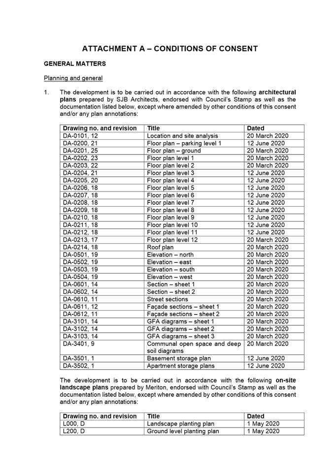
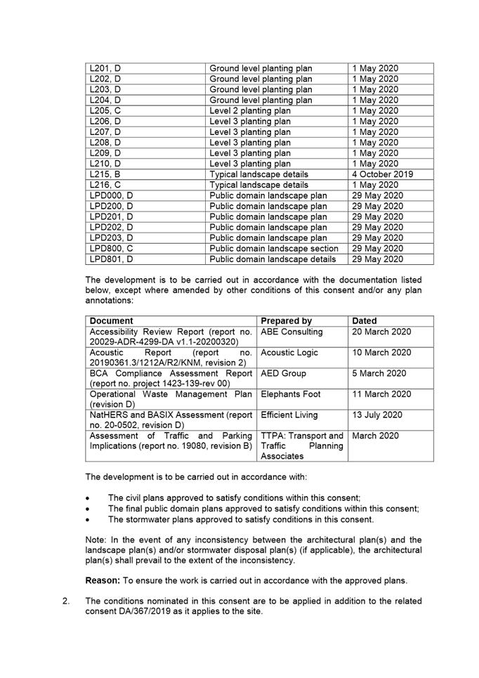
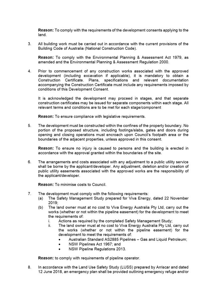
|
Item 5.1 - Attachment 1 |
Attachment 1: Assessment Report & Conditions |


NOTICE OF Local Planning Panel MEETING
PUBLIC AGENDA
An Ordinary Local Planning Panel will be held remotely via electronic means Tuesday, 18 August 2020.
Brett Newman
CHIEF EXECUTIVE OFFICER
THIS PAGE LEFT BLANK INTENTIONALLY
Local Planning Panel 18 August 2020
TABLE OF CONTENTS
ITEM SUBJECT PAGE NO
1 ACKNOWLEDGMENT OF THE TRADITIONAL LAND OWNERS
The City of Parramatta Council acknowledges the Burramattagal Clan of The Darug, the traditional land owners of Parramatta and pays its respects to the elders both past and present
2 WEBCASTING ANNOUNCEMENT
This public meeting will be recorded. The recording will be archived and available on Council’s website.
All care is taken to maintain your privacy; however if you are in attendance in the public gallery, you should be aware that your presence may be recorded.
3 APOLOGIES
4 DECLARATIONS OF INTEREST
5 Reports - Development Applications
5.1 OUTSIDE PUBLIC MEETING: 11A and 13 Carter Street, Lidcombe (Lot 6 & 7 DP 1228764).......................................................................................... 6
5.2 OUTSIDE PUBLIC MEETING: 12 James Street, Carlingford (Lot 1 DP 120826).................................................................................................... 97
5.3 OUTSIDE PUBLIC MEETING: Garside Park, 1-3 Onslow Street, GRANVILLE NSW 2142 (Lots 1-2 DP 537684, Lot 1 DP 336811, Lot 359 DP 752058)........................................................................................... 233
Nil
Development Applications
18 August 2020
5.1 OUTSIDE PUBLIC MEETING: 11A and 13 Carter Street, Lidcombe (Lot 6 & 7 DP 1228764).............................................................................................................. 6
5.2 OUTSIDE PUBLIC MEETING: 12 James Street, Carlingford (Lot 1 DP 120826) 97
5.3 OUTSIDE PUBLIC MEETING: Garside Park, 1-3 Onslow Street, GRANVILLE NSW 2142 (Lots 1-2 DP 537684, Lot 1 DP 336811, Lot 359 DP 752058)........................................................................................................... 233
Local Planning Panel 18 August 2020 Item 5.1
ITEM NUMBER 5.1
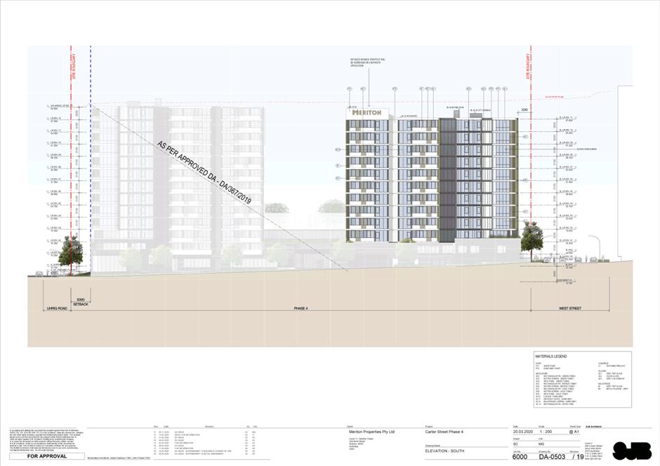
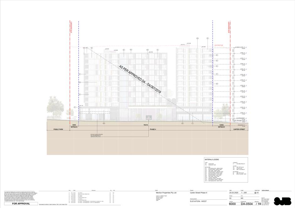
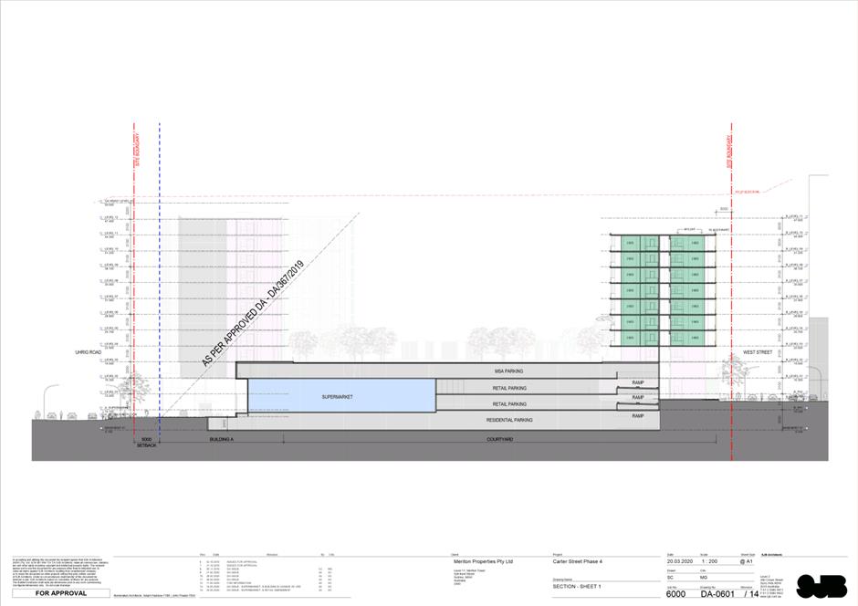
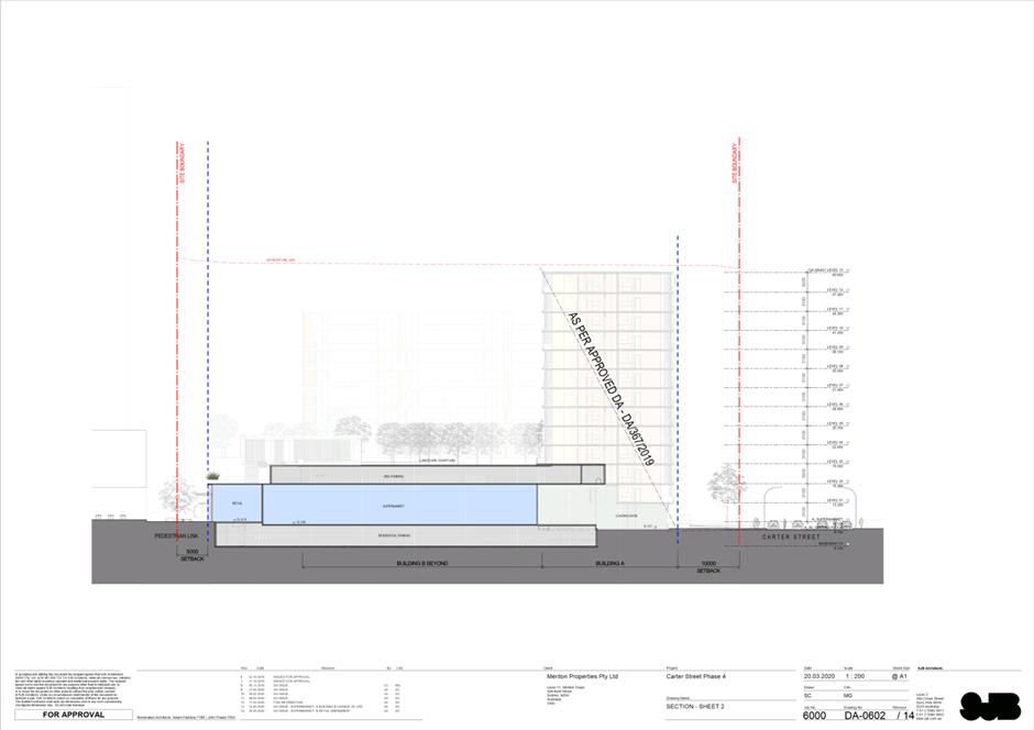
SUBJECT OUTSIDE PUBLIC MEETING: 11A and 13 Carter Street, Lidcombe (Lot 6 & 7 DP 1228764)
DESCRIPTION Change of use from serviced apartments to residential apartments for levels 3-11 in building B and associated works including reconfiguration of parking, reconfiguration of ground floor (including reduction in supermarket size, inclusion of new retail tenancies), facade changes, minor floor plan reconfigurations of building B.
REFERENCE DA/164/2020 -
APPLICANT/S Karimbla Properties (No. 51) Pty Ltd
OWNERS Karimbla Properties (No. 51) Pty Ltd
REPORT OF Group Manager Development and Traffic Services
|
This matter has received less than ten (10) unique submissions and will be considered outside of a public meeting as per Local Planning Panels Direction – Operational Procedures dated 30 June 2020 made under section 9.1 of the Environmental Planning and Assessment Act 1979.
DATE OF REPORT 18 August 2020
REASON FOR REFERRAL TO LPP
The development is being partly converted to a residential flat building to which state Environmental Planning Policy No. 65 – Design Quality of Residential Apartment Development.
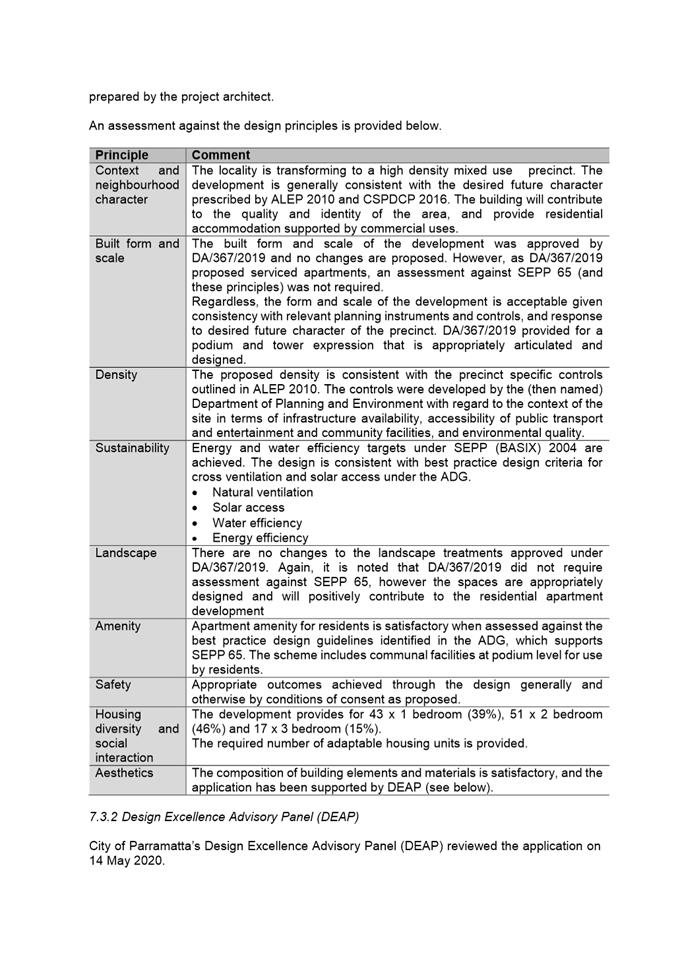
EXECUTIVE SUMMARY
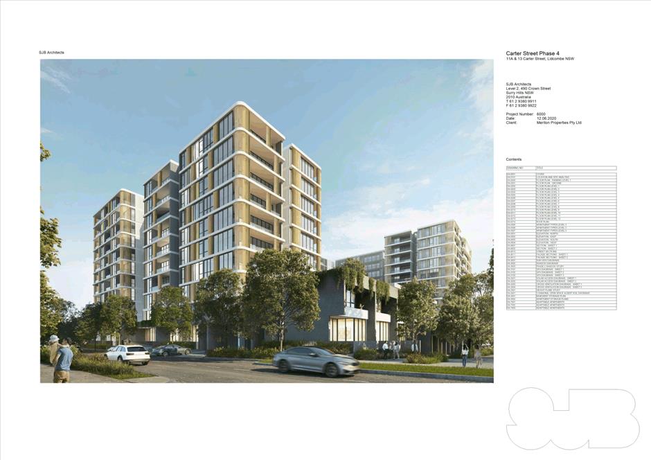
The report considers a proposal for the change of use from serviced apartments to residential apartments for levels 3-11 in building B, and associated works, including reconfiguration of parking, reconfiguration of ground floor (including reduction in supermarket size and inclusion of new retail tenancies), façade changes, and minor floor plan reconfigurations of building B.
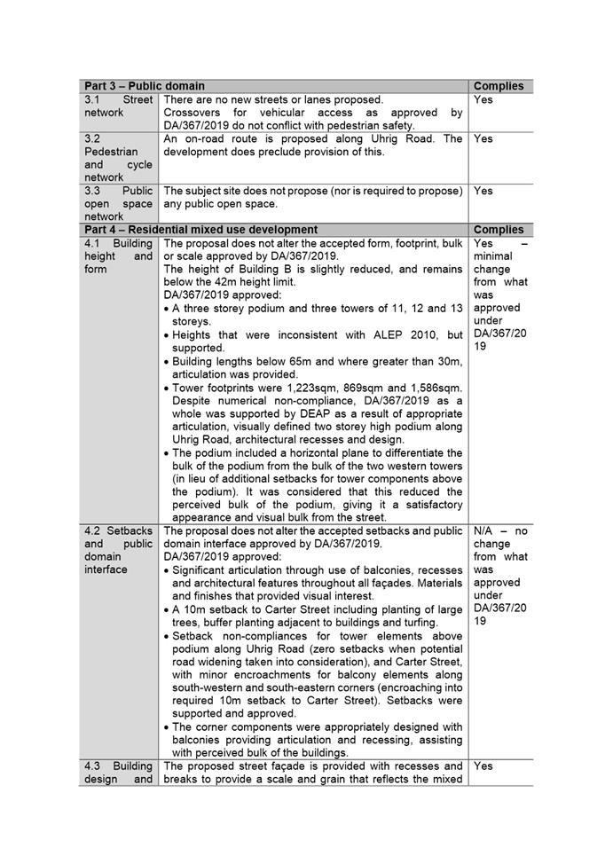
The change of use relates to a mixed use development with serviced apartments, a supermarket and retail tenancies approved under DA/367/2019 by the Sydney Central Planning Panel (SCCPP) on 4 December 2019 (.
Following assessment of the application against the relevant statutory planning framework, and consideration of matters raised in referrals, it is deemed that the proposal is satisfactory.
While a non-compliance with the Carter Street Precinct Development Control Plan 2016 (CSPDCP 2016) is proposed for parking, the development is considered acceptable given the consent already approved for the site (DA/367/2019), the development’s quality design and appearance, and overall built form and aesthetics.
The amenity impacts on adjoining and nearby properties are considered reasonable based on the site’s location in a steadily progressing priority precinct.
The application has been assessed relative to section 4.15 of the Environmental Planning and Assessment Act 1979, taking into consideration relevant State and local planning controls. On balance, the proposal has responded satisfactorily to the objectives and controls of the relevant statutory planning framework.
This report recommends that the Panel approve the application, subject to the recommended conditions.
Proposed development
The proposed development includes change of use from serviced apartments to residential apartments for levels 3-11 in building B, with associated works. In summary, the following works are proposed:
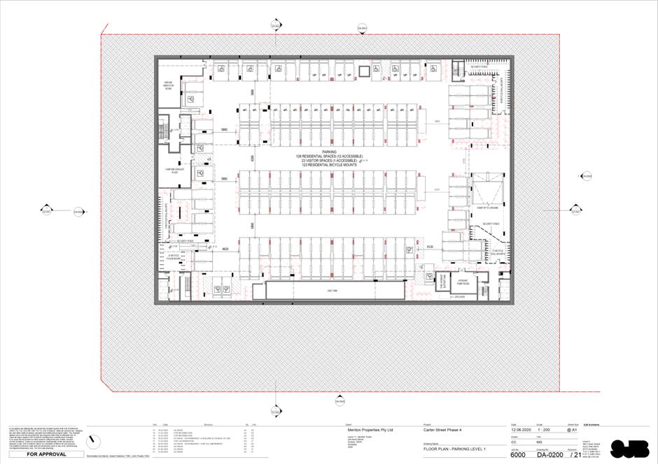
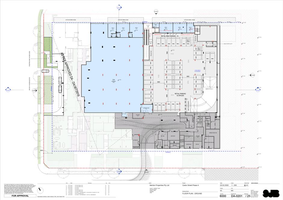
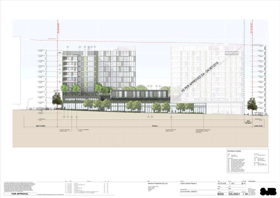
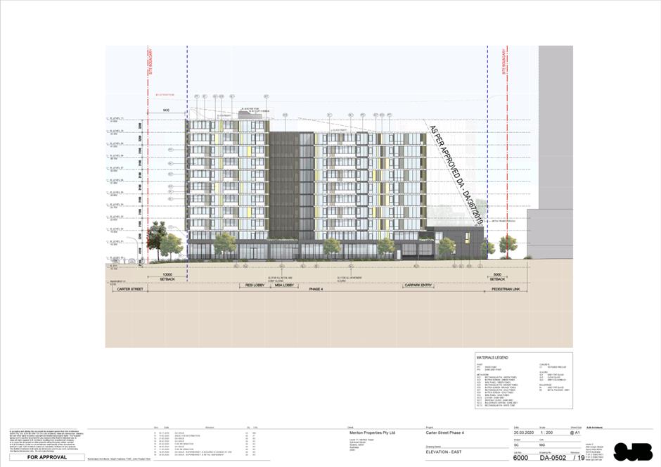
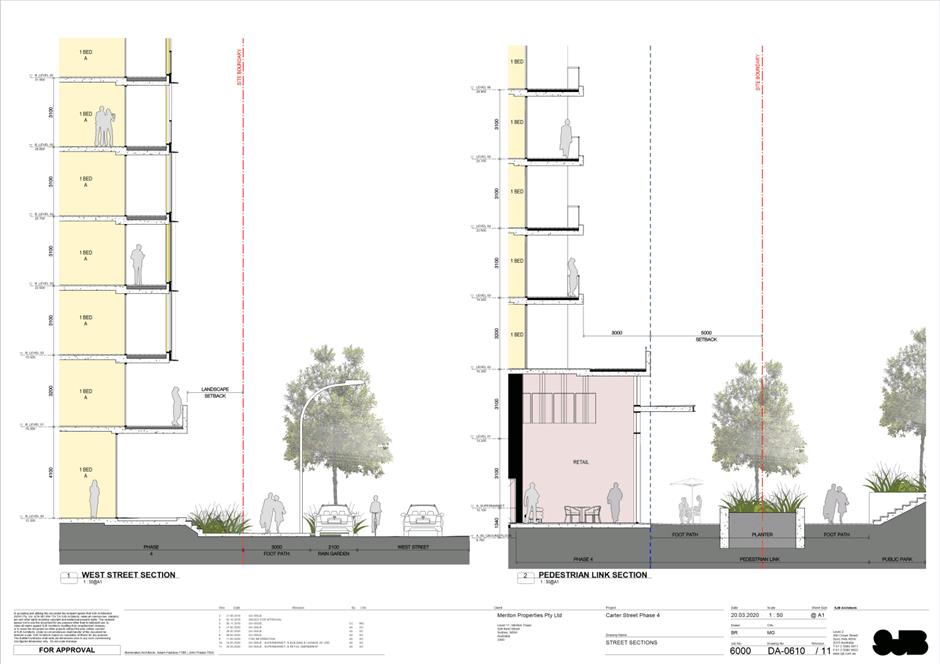
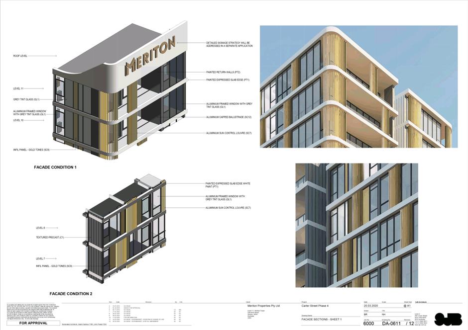
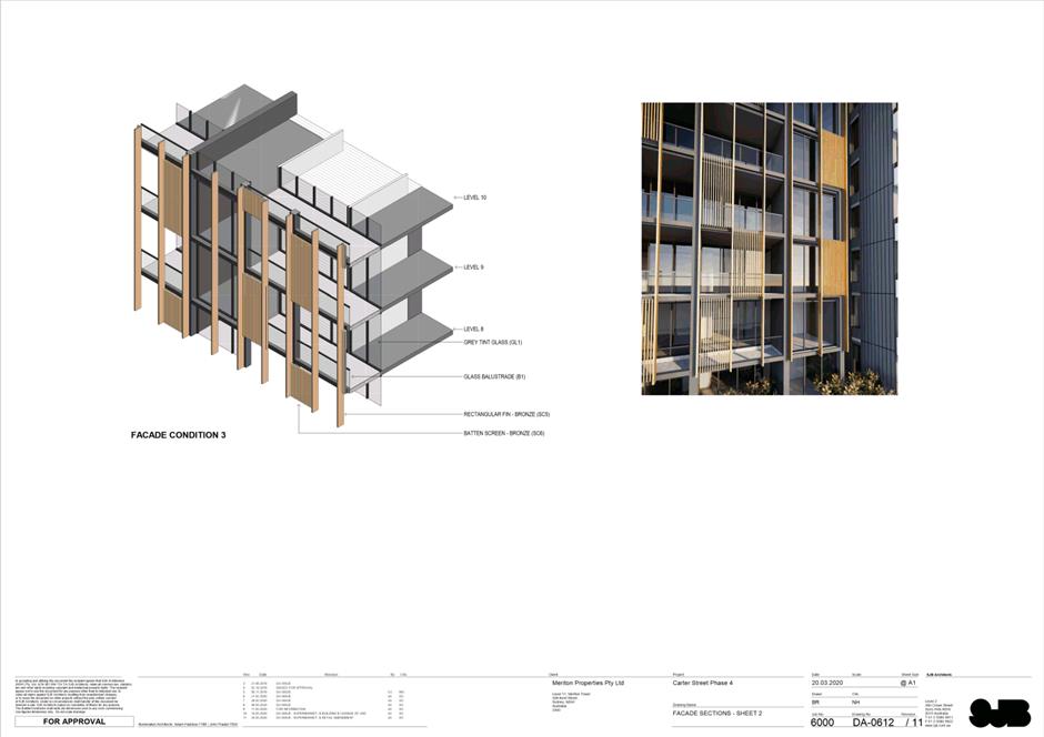
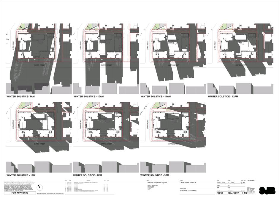
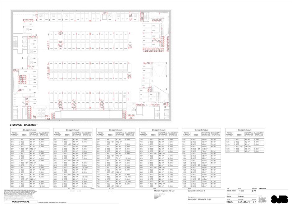
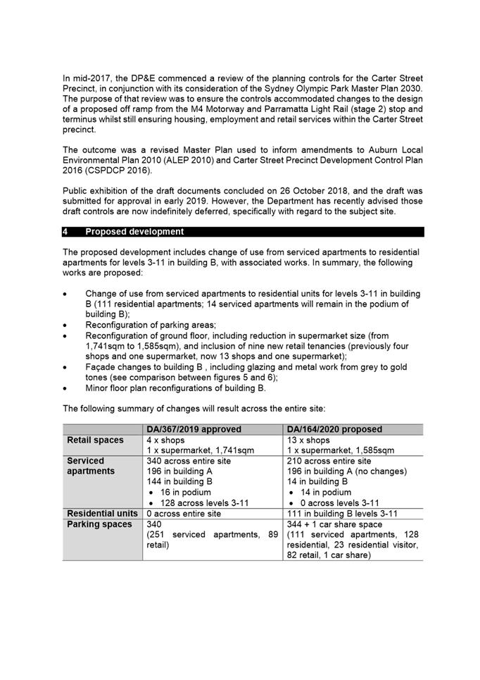
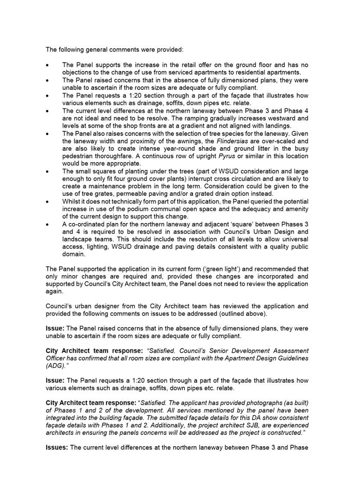
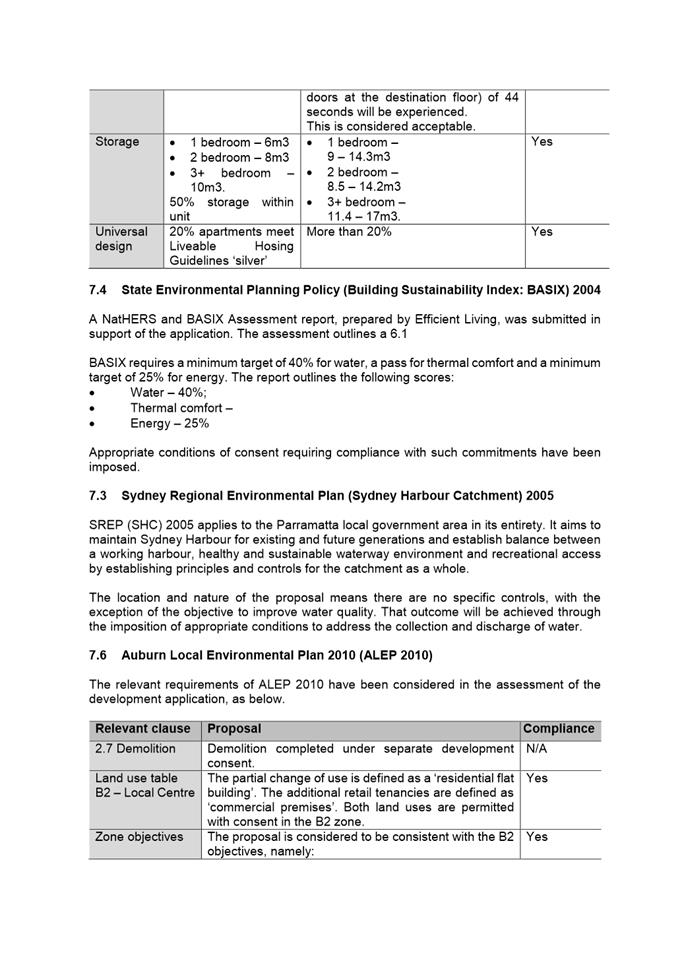
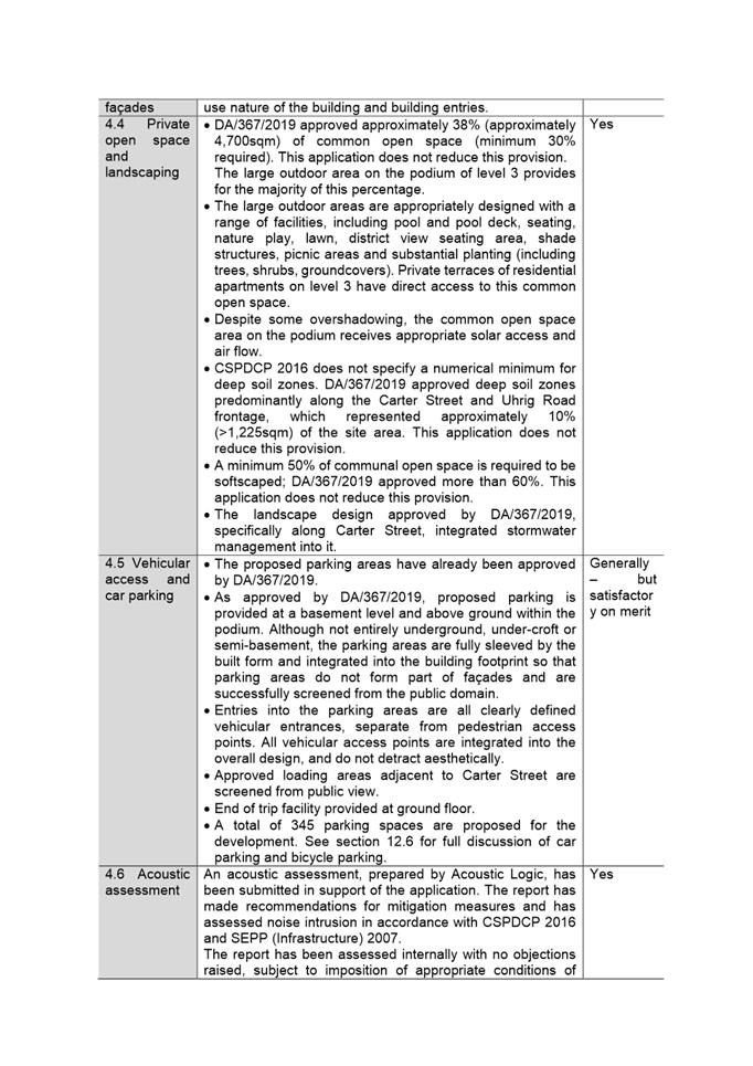
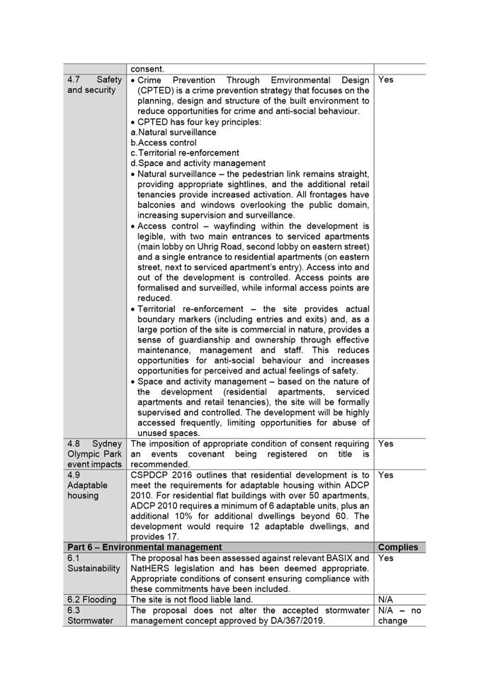
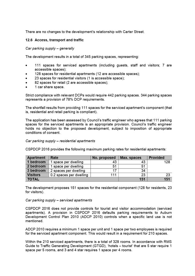
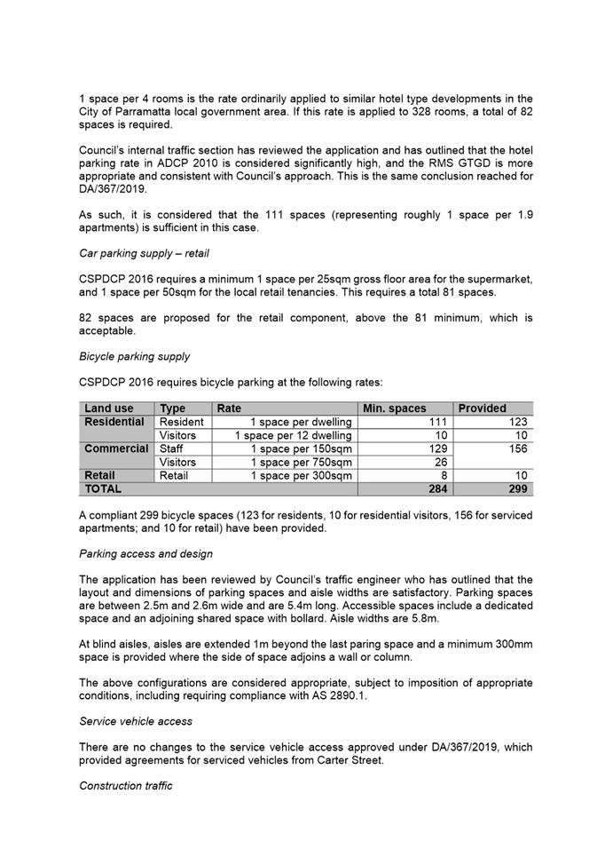
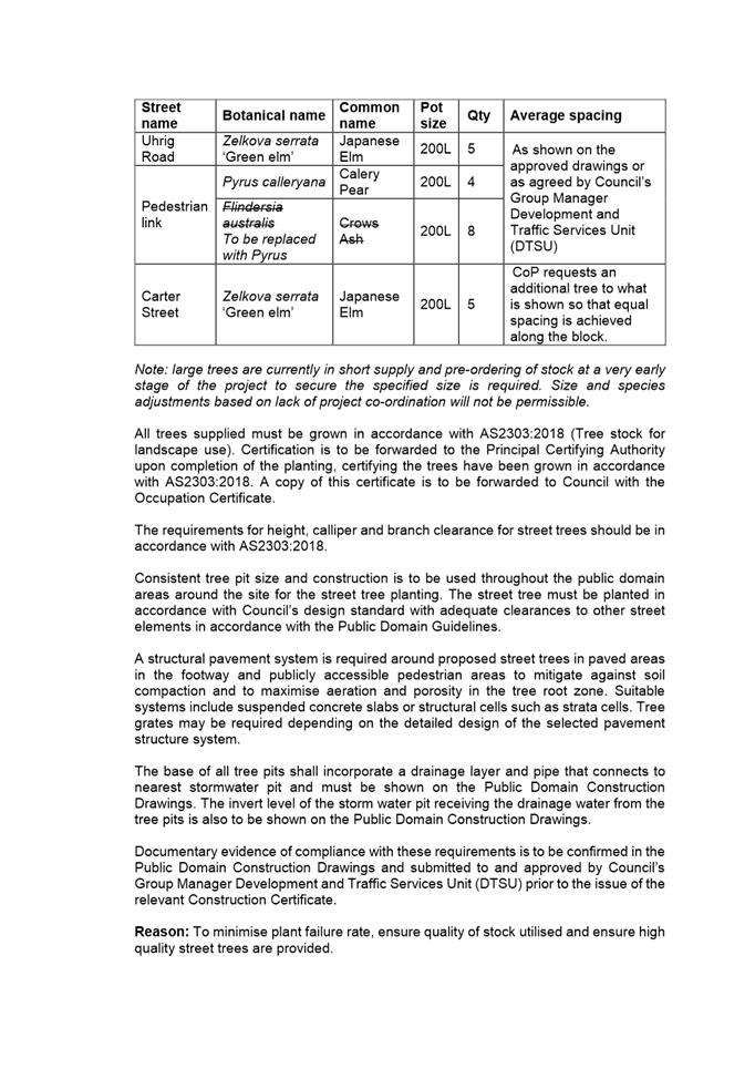
· Change of use from serviced apartments to residential units for levels 3-11 in building B (111 residential apartments; 14 serviced apartments will remain in the podium of building B); · Reconfiguration of parking areas; · Reconfiguration of ground floor, including reduction in supermarket size (from 1,741sqm to 1,585sqm), and inclusion of nine new retail tenancies (previously four shops and one supermarket, now 13 shops and one supermarket); · Façade changes to building B , including glazing and metal work from grey to gold tones (see comparison between figures 5 and 6); · Minor floor plan reconfigurations of building B.
The following summary of changes will result across the entire site:
Site and locality
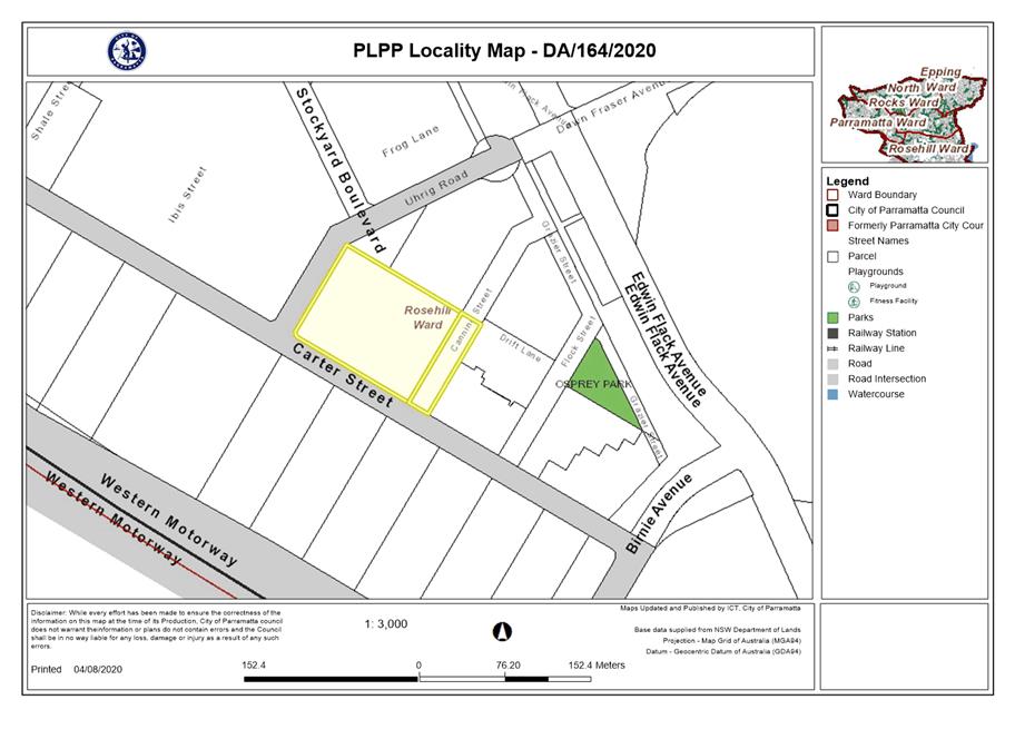
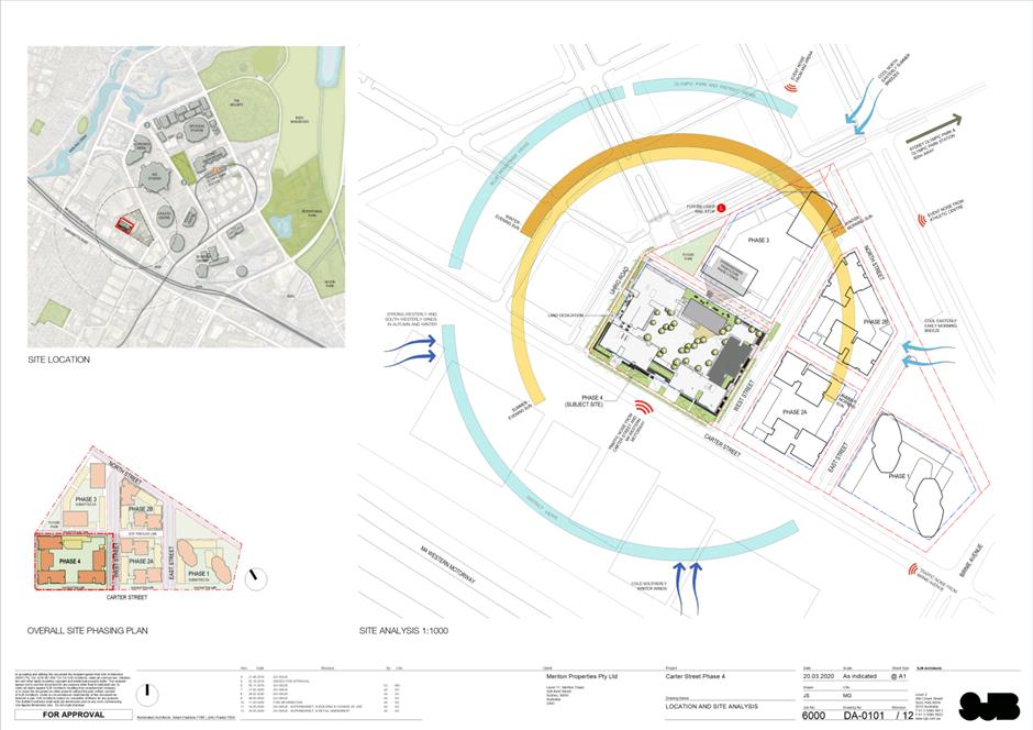
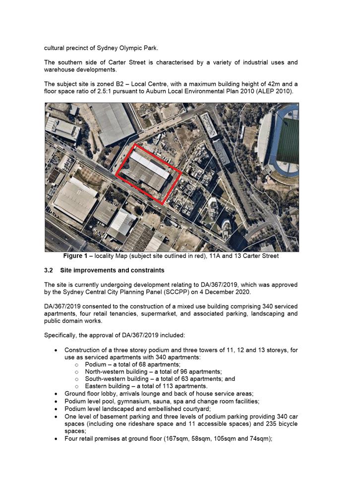
The subject site (‘Phase 4’) includes Lots 6 and 7 DP 1228764, known as 11A and 13 Carter Street, Lidcombe (‘West Street’ being 11A Carter Street; development lot being 13 Carter Street).
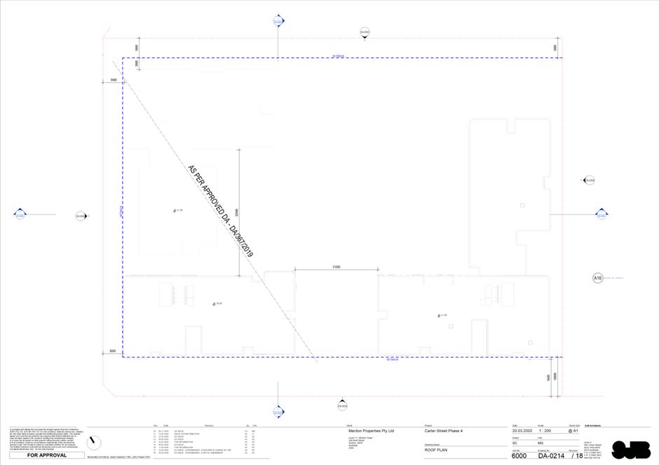
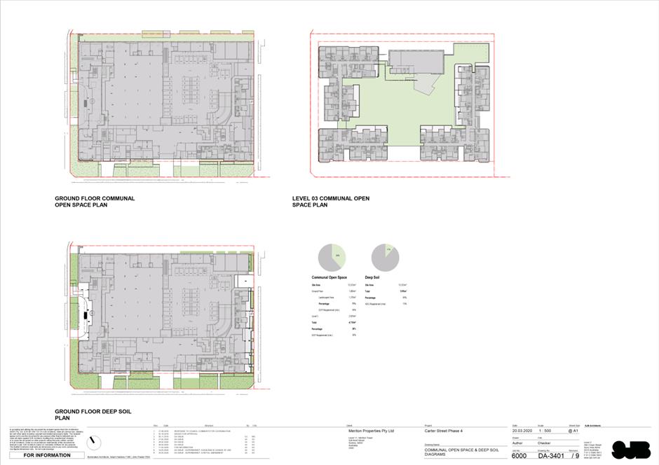
The subject site has a total approximate area of 12,533sqm, which includes 10,705sqm for the development lot, and 1,828sqm for road and associated public infrastructure. The site has a general fall towards the western corner, with changes in level of about 1m along the Uhrig Road frontage, and about 1.5m along the eastern boundary.
The site is located at the intersection of Carter Street and Uhrig Road, with an approximate frontage of 115m to Carter Street to the south, and an approximate frontage of 90m to Uhrig Road to the west.
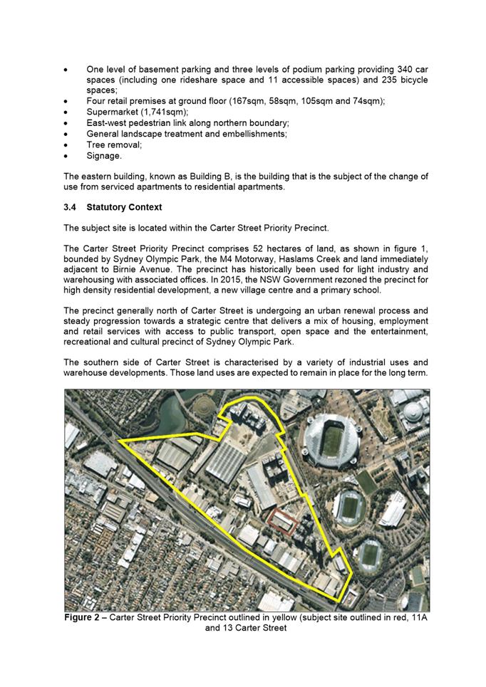
The site is located in the Carter Street Priority Precinct, which comprises 52 hectares of land bounded by Sydney Olympic Park, the M4 Motorway, Haslams Creek and land immediately adjacent to Birnie Avenue. The precinct has historically been used for light industry and warehousing with associated offices. In 2015, the NSW Government rezoned the precinct for high density residential development, a new village centre and a primary school.
Land to the northern side of Carter Street is undergoing an urban renewal process and steady progression towards a strategic centre that delivers a mix of housing, employment and retail services with access to public transport, open space and the entertainment, recreational and cultural precinct of Sydney Olympic Park.
The southern side of Carter Street is characterised by a variety of industrial uses and warehouse developments.
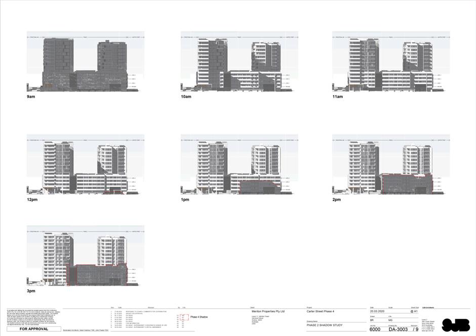
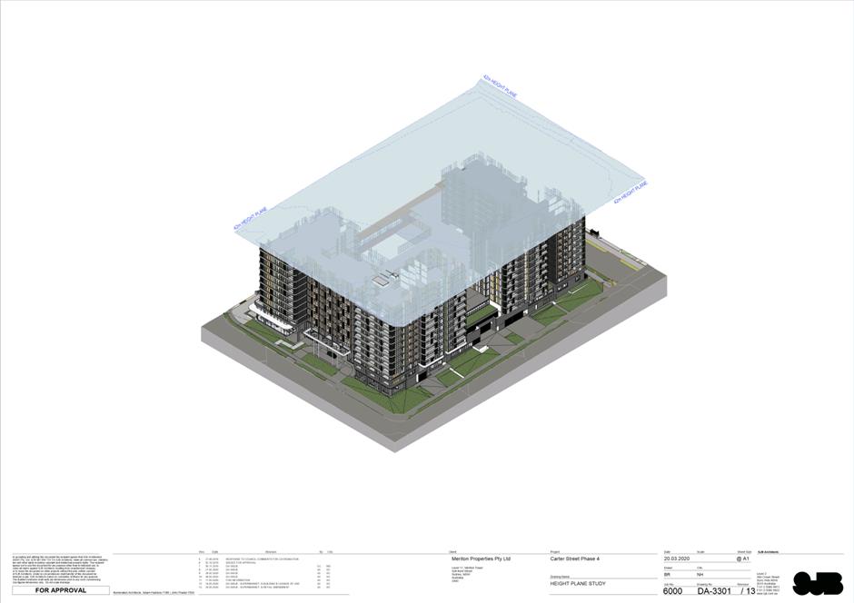
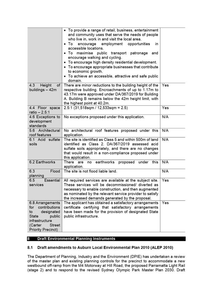
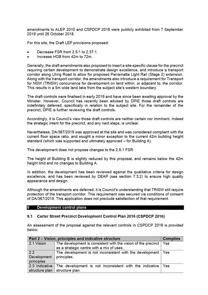
The subject site is zoned B2 – Local Centre, with a maximum building height of 42m and a floor space ratio of 2.5:1 pursuant to Auburn Local Environmental Plan 2010 (ALEP 2010).
Consultation
The application was referred internally and externally to the following. No objections were raised to the development. Appropriate conditions of consent to be imposed.
Internal · Landscape and tree management; · Internal catchment development engineer · Traffic · Environmental health – acoustic · Urban design (public domain) · Social outcomes · Environmental sustainability · Universal access · Waste
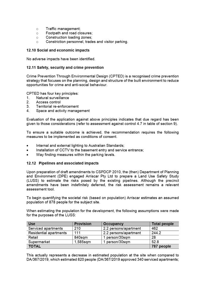
External · Transport for NSW (including Roads and Maritime Services) · Department of Planning, Industry and Environment · Hazards branch of Department of Planning, Industry and Environment · Ausgrid · Sydney Olympic Park Authority · Sydney Water · Caltex · Viva Energy
The application was notified and advertised in accordance with the relevant development control plan, for a period of 14 days between 10 June and 24 June 2020. There were no submissions received. |
|
That the Parramatta Local Planning Panel, as the consent authority grant consent subject to the conditions of consent to development application no. DA/164/2020 for the change of use from serviced apartments to residential apartments for levels 3-11 in building B and associated works including reconfiguration of parking, reconfiguration of ground floor (including reduction in supermarket size and inclusion of new retail tenancies), façade changes, and minor floor plan reconfigurations of building B at Lots 6 and 7 DP 1228764, 11A and 13 Carter Street, Lidcombe.
|
Andrew Golden
Senior Development Assessment Officer
|
1⇩ |
Attachment 1: Assessment Report & Conditions |
66 Pages |
|
|
2⇩ |
Attachment 2: Locality Map |
1 Page |
|
|
3⇩ |
Attachment 3: Plans used during assessment |
20 Pages |
|
|
Attachment 4: Internal plans used during assessment (confidential) |
25 Pages |
|
|
|
Attachment 5: DEAP Comments (confidential) |
4 Pages |
|
ITEM NUMBER 5.2
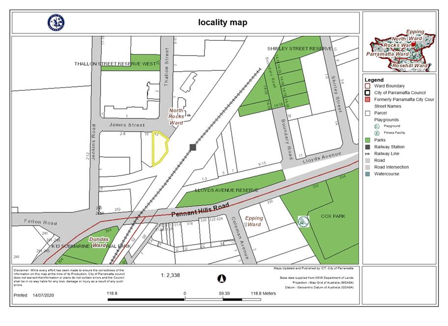
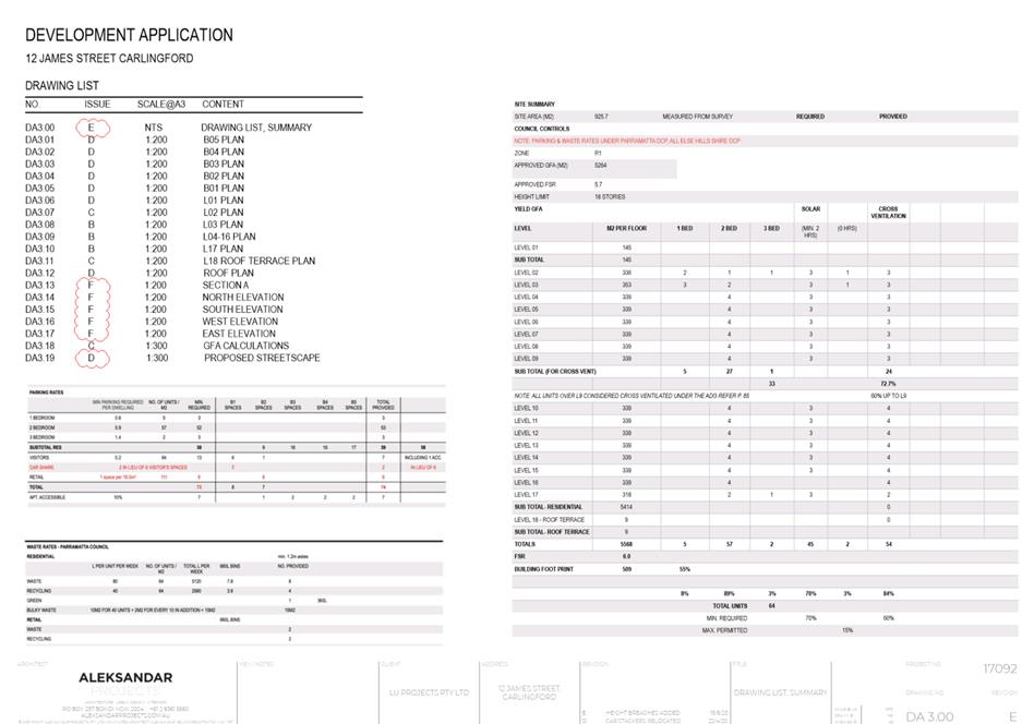
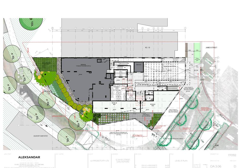
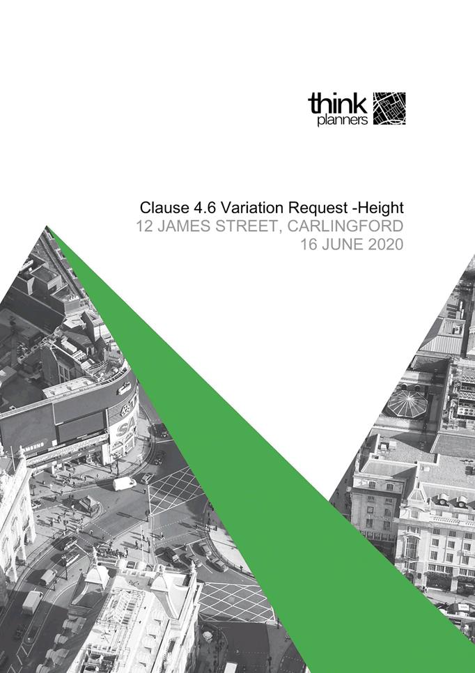
SUBJECT OUTSIDE PUBLIC MEETING: 12 James Street, Carlingford (Lot 1 DP 120826)
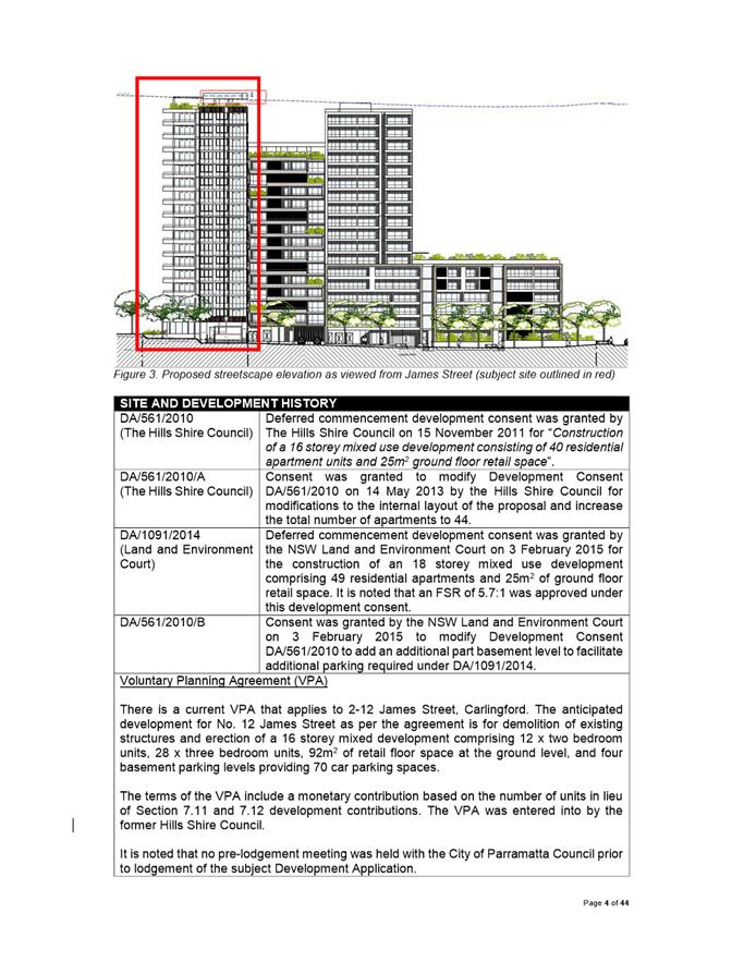
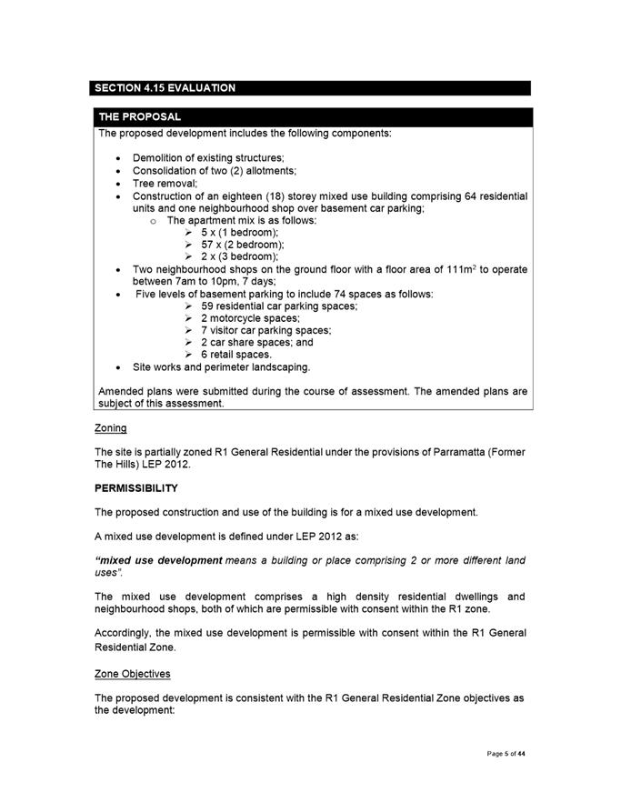
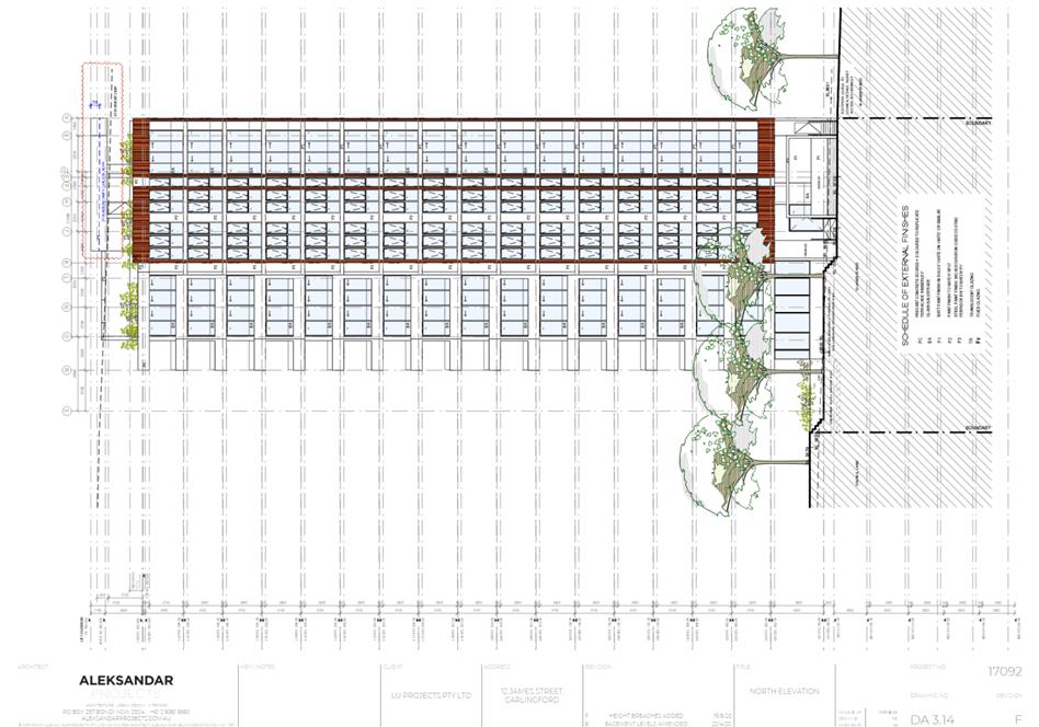
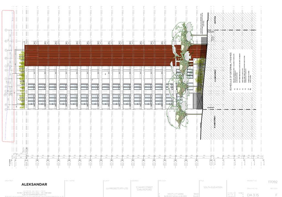
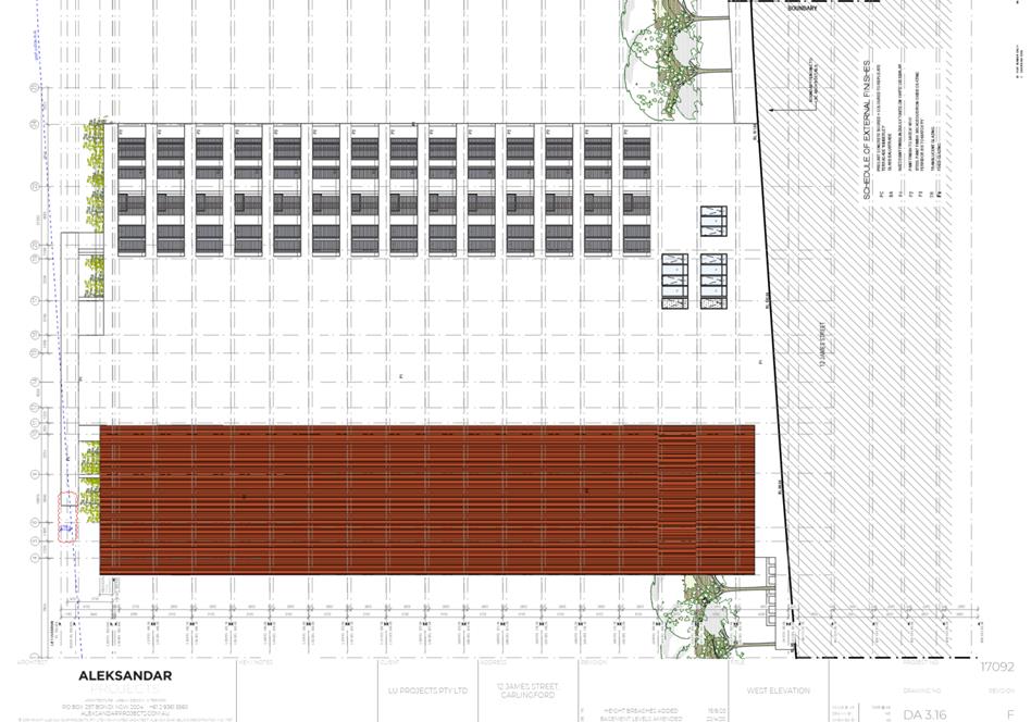
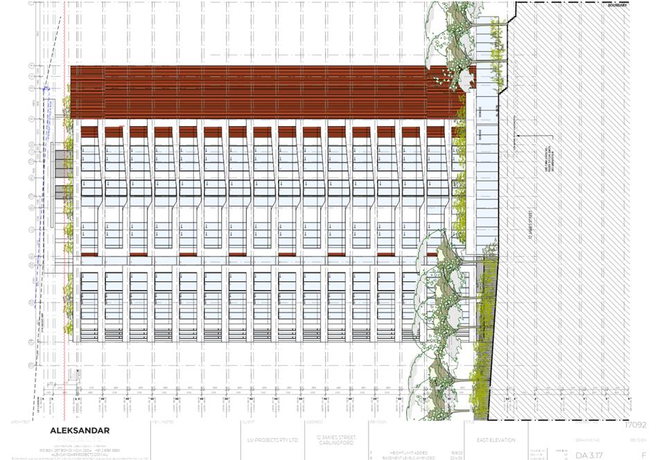
DESCRIPTION Demolition of existing structures, tree removal and the construction of an eighteen (18) storey mixed use development containing 64 apartments and ground floor retail space over 5 levels of basement parking. The proposal is Integrated Development under the Water Management Act 2000.
REFERENCE DA/80/2019 -
APPLICANT/S LU PROJECTS PTY LIMITED
OWNERS Paramount Investments Pty Limited and Carlingford Investments Pty Limited
REPORT OF Group Manager Development and Traffic Services
|
This matter has received less than ten (10) unique submissions and will be considered outside of a public meeting as per Local Planning Panels Direction – Operational Procedures dated 30 June 2020 made under section 9.1 of the Environmental Planning and Assessment Act 1979.
DATE OF REPORT 18 august 2020
REASON FOR REFERRAL TO LPP
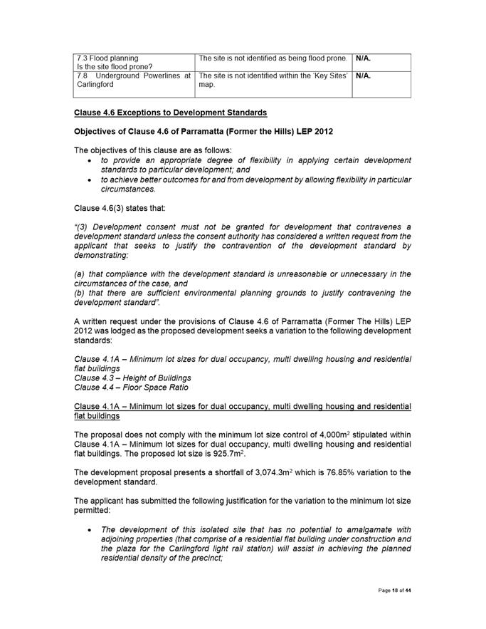
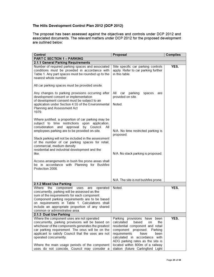
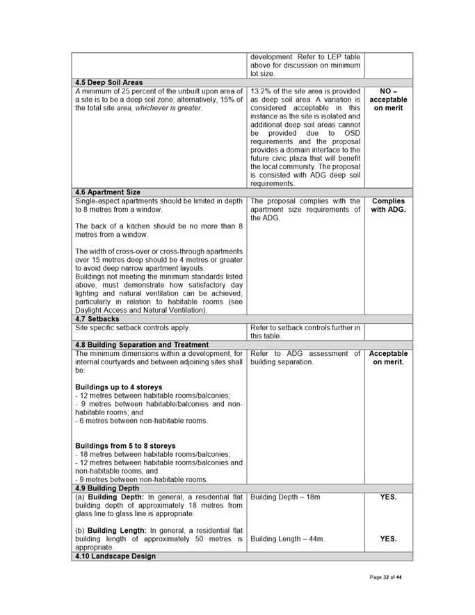
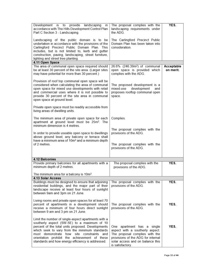
This report is referred to the Parramatta Local Planning Panel as the proposed development is subject to the provisions of SEPP 65 – Design Quality of Residential Apartment Development. This application is also referred to the Parramatta Local Planning Panel as a variation greater than 10% is proposed to development standards, Clause 4.1A – Minimum Lot Size and Clause 4.4 – Floor Space Ratio, pursuant to Clause 4.6 of the Parramatta (Former The Hills) Local Environmental Plan 2012.
EXECUTIVE SUMMARY
This is a summary of the full assessment of the application as outlined in Attachment 1, the Section 4.15 Assessment Report.
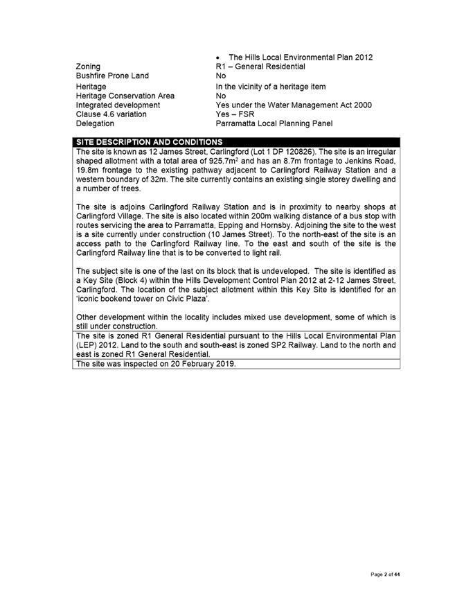
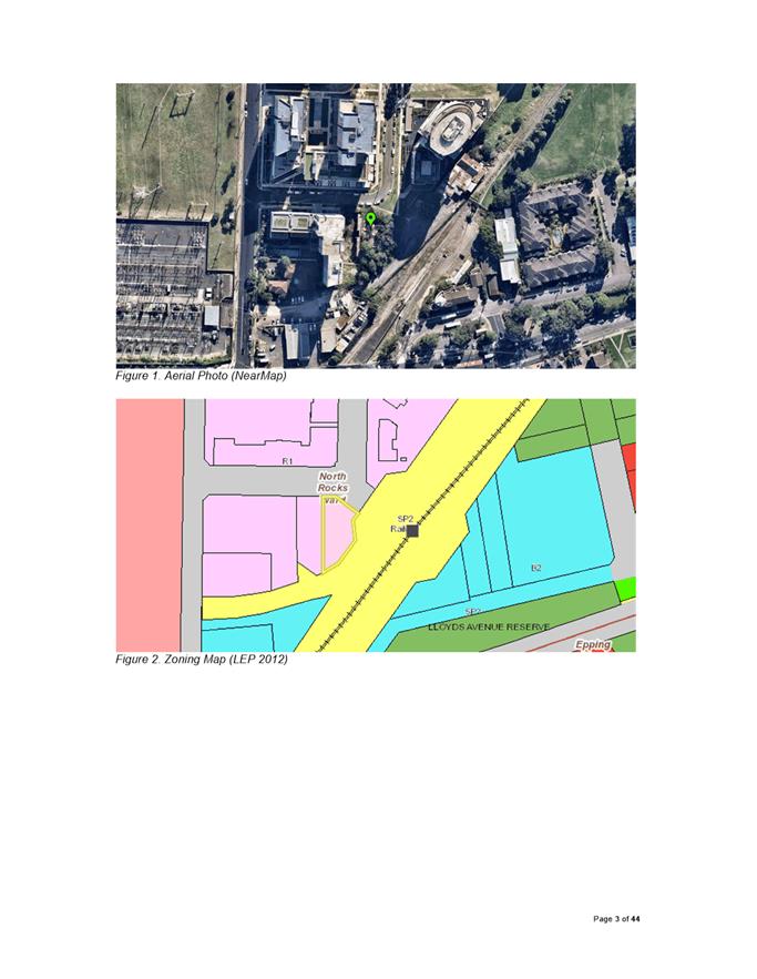
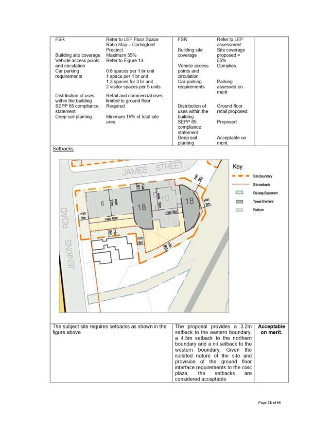
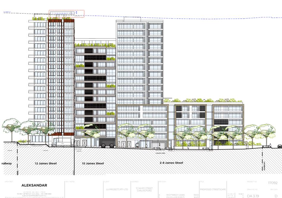
The Site The site is known as 12 James Street, Carlingford (Lot 1 DP 120826). The site is an irregular shaped allotment with a total area of 925.7m2 and has an 8.7m frontage to Jenkins Road, 19.8m frontage to the existing pathway adjacent to Carlingford Railway Station and a western boundary of 32m. The site currently contains an existing single storey dwelling and a number of trees.
The site is adjoins Carlingford Railway Station and is proximity to nearby shops at Carlingford Village. Adjoining the site to the west is a site currently under construction (10 James Street). To the north-east of the site is an access path to the Carlingford Railway line. To the east and south of the site is the Carlingford Railway line that is to be converted to light rail.
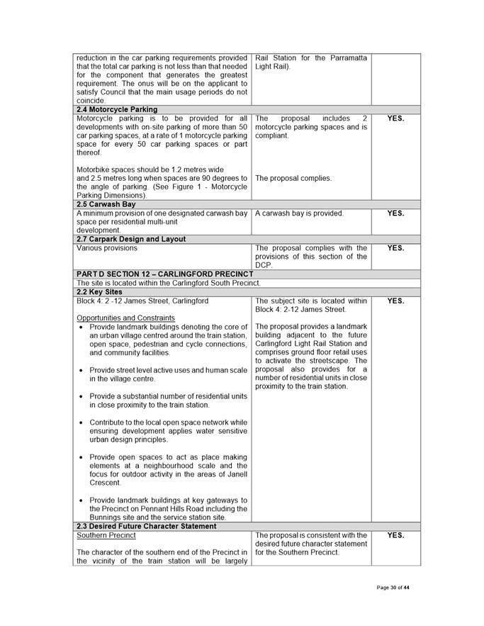
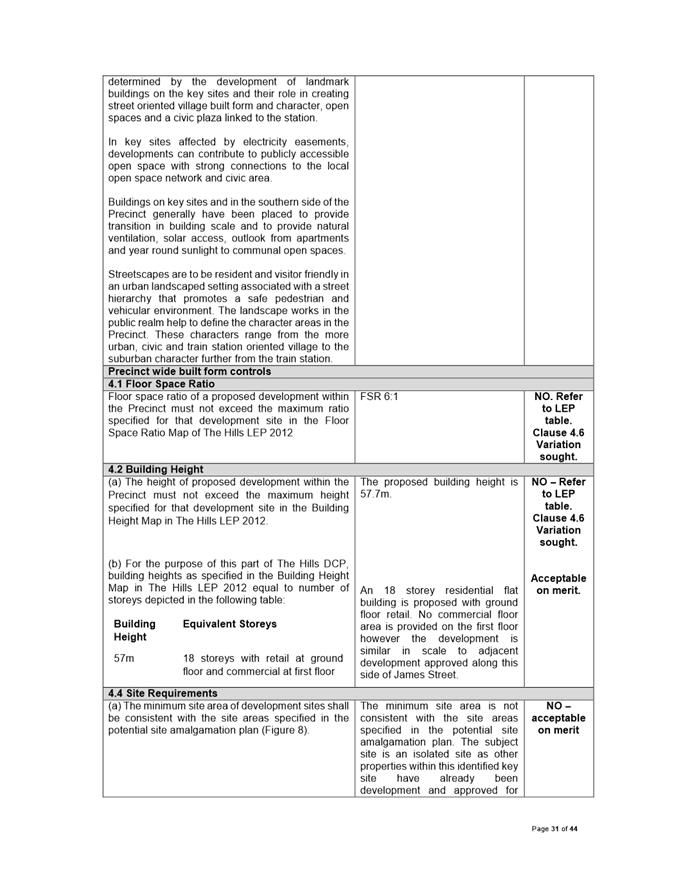
The subject site is one of the last on its block that is undeveloped. The site is identified as a Key Site (Block 4) within the Hills Development Control Plan 2012 at 2-12 James Street, Carlingford. The location of the subject allotment within this Key Site is identified for an ‘iconic bookend tower on Civic Plaza’.
Other development within the locality includes mixed use development, some of which is still under construction.
The site is zoned R1 General Residential pursuant to the Hills Local Environmental Plan (LEP) 2012. Land to the south and south-east is zoned SP2 Railway. Land to the north and east is zoned R1 General Residential.
The Proposed Development
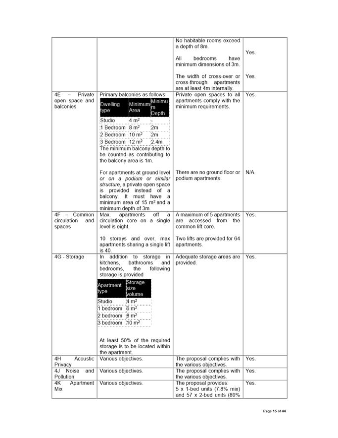
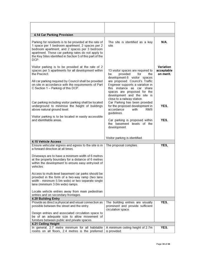
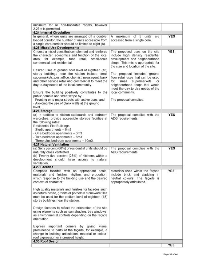
· Demolition of existing structures; · Consolidation of two (2) allotments; · Tree removal; · Construction of an eighteen (18) storey mixed use building comprising 64 residential units and one neighbourhood shop over basement car parking; o The apartment mix is as follows: Ø 5 x (1 bedroom); Ø 57 x (2 bedroom); Ø 2 x (3 bedroom); · Two neighbourhood shops on the ground floor with a floor area of 111m2 to operate between 7am to 10pm, 7 days; · Five levels of basement parking to include 74 spaces as follows: Ø 59 residential car parking spaces; Ø 2 motorcycle spaces; Ø 7 visitor car parking spaces; Ø 2 car share spaces; and Ø 6 retail spaces. · Site works and perimeter landscaping.
The development proposed is a mixed use development. The mixed use development comprises a high density residential dwellings and neighbourhood shops, both of which are permissible with consent within the R1 zone.
Accordingly, the mixed use development is permissible with consent within the R1 General Residential Zone.
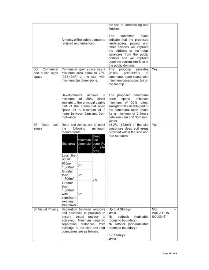
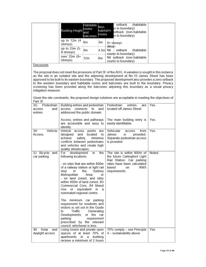
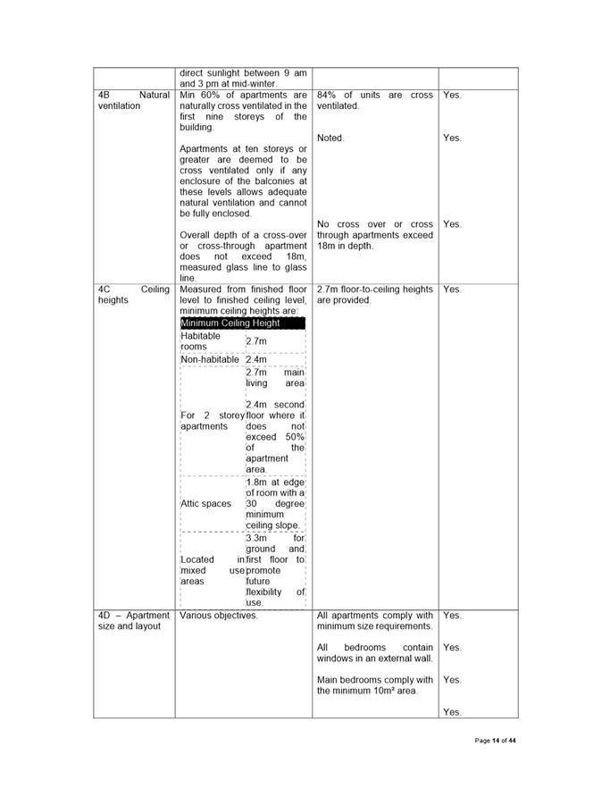
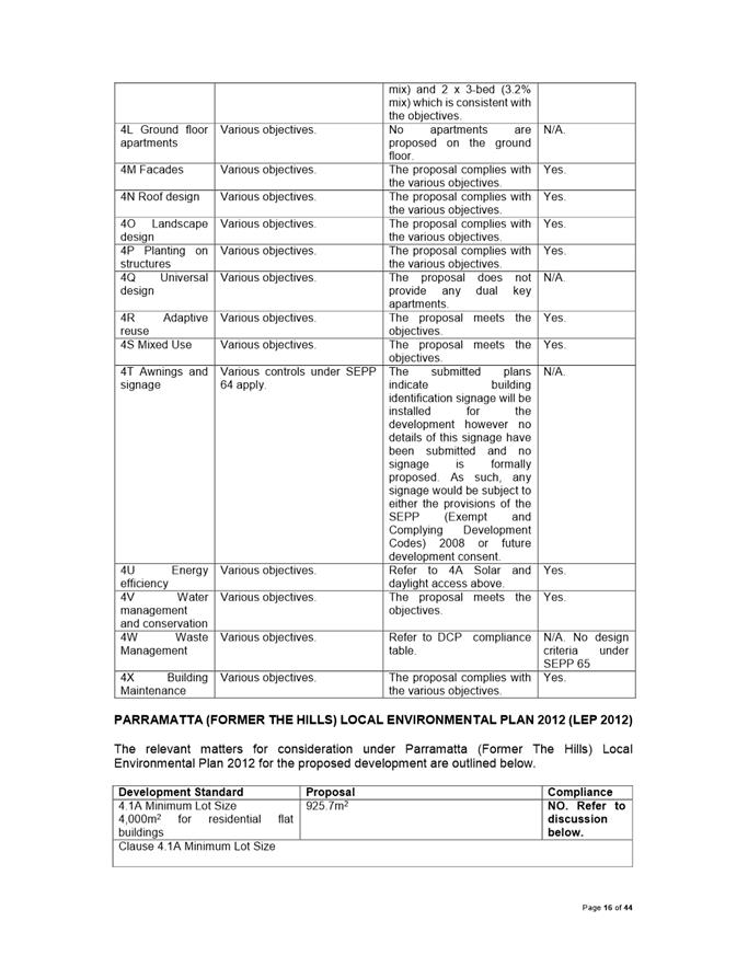
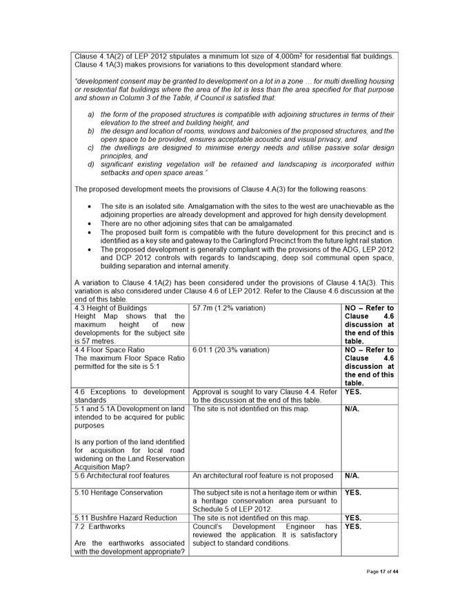
The application proposes a lot size that is under the minimum 4,000m2 lot size for residential flat buildings. The site has an area of 925.7m2 The proposal presents a 76.85% variation to Clause 4.1A - Minimum lot sizes for dual occupancy, multi dwelling housing and residential flat buildings. The application was accompanied by a Clause 4.6 Statement, which is considered well founded.
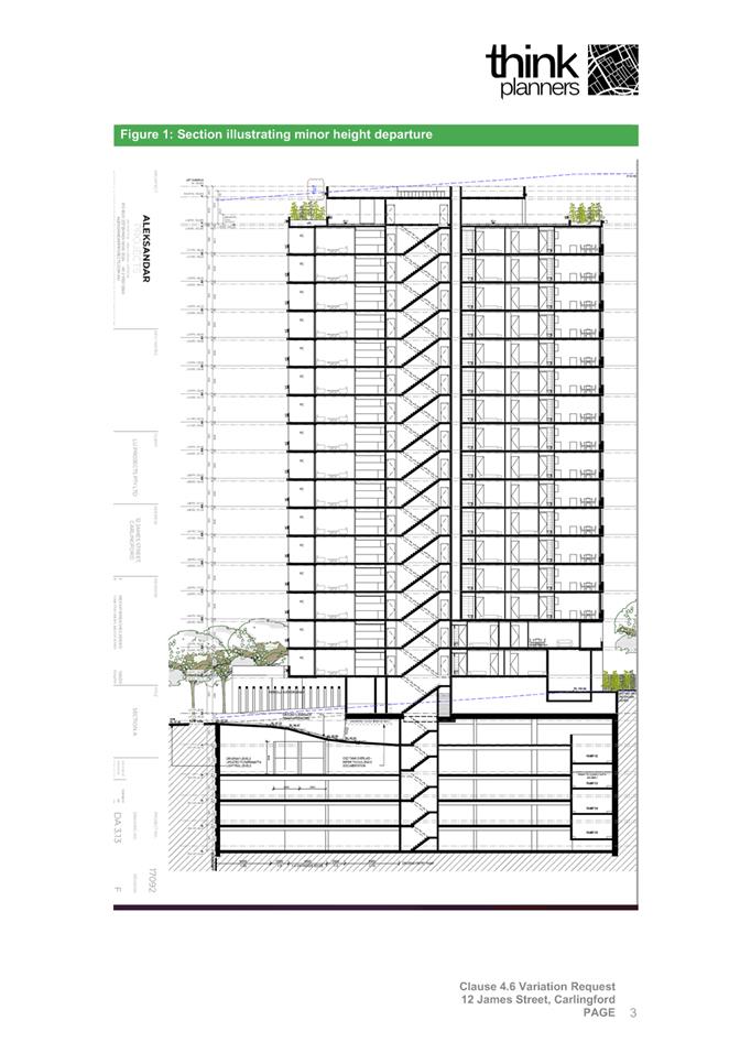
The application proposes to exceed the 57m maximum building height control by 0.7m (1.2% variation), resulting in a maximum height of 57.7m above natural ground level. The non-compliant portion of the building comprises the lift overrun. The application was accompanied by a Clause 4.6 Statement, which is considered well founded.
The application proposes to exceed the 5:1 maximum floor space ratio control by 1.03:1 (20.3% variation), resulting in a total floor space ratio of 6.01:1. The application was accompanied by a Clause 4.6 Statement, which is considered well founded.
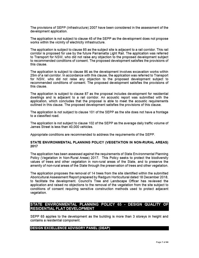
The proposal was referred to Council’s Design Excellence Advisory Panel, Development Engineer, Heritage Advisor, Traffic Engineer, Landscape and Tree Officer, Urban Design (Public Domain) Officer and Environmental Health Officer. The application was also referred to Transport for NSW, Water NSW and Endeavour Energy. No objections were raised subject to recommended conditions of consent.
The application was notified in accordance with Council’s notification procedures contained within DCP 2012. In response no submissions were received.
Amended plans and documentation were submitted during the course of assessment with the following changes: · Amended architectural plans submitted with the following changes: o Relocation of bin storage area; o Increased floor area for ground floor retail and amendments to the ground floor retail interface; o Reduction of driveway width; o Reduction of Gross Floor Area; o Reconfiguration of a number of internal apartment layouts; · Amended stormwater and landscape plans to reflect the changes made in the amended architectural plans.
In accordance with The Hills DCP 2012 – Part A: 2.1 Notifiable Development notification procedures the application did not require re-notification as the amended application is considered to be substantially the same development and does not have the potential to alter the amenity of surrounding properties.
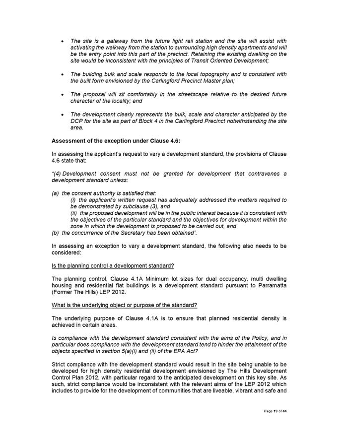
After consideration of the development against Section 4.15 of the Environmental Planning and Assessment Act 1979, and the relevant statutory and policy provisions, the proposal is suitable for the site and is in the public interest. It is recommended that the application be approved for the following reasons:
1. The development is permissible in the R1 zone and satisfies the requirements of all of the applicable planning controls.
2. The variation to minimum lot size area prescribed in Clause 4.1A – Minimum lot sizes for dual occupancy, multi dwelling housing and residential flat buildings in Parramatta (Former The Hills) Local Environmental Plan 2012, under the provisions of Clause 4.6 – Variations to Development Standards satisfies the objectives of the control and the R1 General Residential zone, and there are sufficient environmental planning grounds to justify the variation.
3. The variation to building height control prescribed in Clause 4.3 – Floor Space Ratio in Parramatta (Former The Hills) Local Environmental Plan 2012, under the provisions of Clause 4.6 – Variations to Development Standards satisfies the objectives of the control and the R1 General Residential zone, and there are sufficient environmental planning grounds to justify the variation.
4. The variation to floor space ratio control prescribed in Clause 4.4 – Floor Space Ratio in Parramatta (Former The Hills) Local Environmental Plan 2012, under the provisions of Clause 4.6 – Variations to Development Standards satisfies the objectives of the control and the R1 General Residential zone, and there are sufficient environmental planning grounds to justify the variation.
5. The development will be compatible with the emerging and planned future character of the area.
For the reasons given above, approval of the application is in the public interest |
|
(a) That Pursuant to Section 4.17 of the Environmental Planning and Assessment Act 1979, that Parramatta Local Planning Panel exercising the functions of Council, grant development consent to DA/80/2019 for demolition of existing structures, tree removal and the construction of an eighteen (18) storey mixed use development containing 64 apartments and ground floor retail space over 5 levels of basement parking at 12 James Street, Carlingford for a period of five (5) years within which physical commencement is to occur from the date on the Notice of Determination, subject to the following conditions held at Attachment 1 of this report.
(b) That Parramatta Local Planning Panel approve a variation to floor space ratio control prescribed in Clause 4.1A – Minimum lot sizes for dual occupancy, multi dwelling housing and residential flat buildings in Parramatta (Former The Hills) Local Environmental Plan 2012, under the provisions of Clause 4.6 – Variations to Development Standards as it satisfies the objectives of the control and the R1 General Residential zone, and there are sufficient environmental planning grounds to justify the variation.
(c) That Parramatta Local Planning Panel approve a variation to floor space ratio control prescribed in Clause 4.3 – Height of Buildings in Parramatta (Former The Hills) Local Environmental Plan 2012, under the provisions of Clause 4.6 – Variations to Development Standards as it satisfies the objectives of the control and the R1 General Residential zone, and there are sufficient environmental planning grounds to justify the variation.
(d) Further, that Parramatta Local Planning Panel approve a variation to floor space ratio control prescribed in Clause 4.4 – Floor Space Ratio in Parramatta (Former The Hills) Local Environmental Plan 2012, under the provisions of Clause 4.6 – Variations to Development Standards as it satisfies the objectives of the control and the R1 General Residential zone, and there are sufficient environmental planning grounds to justify the variation.
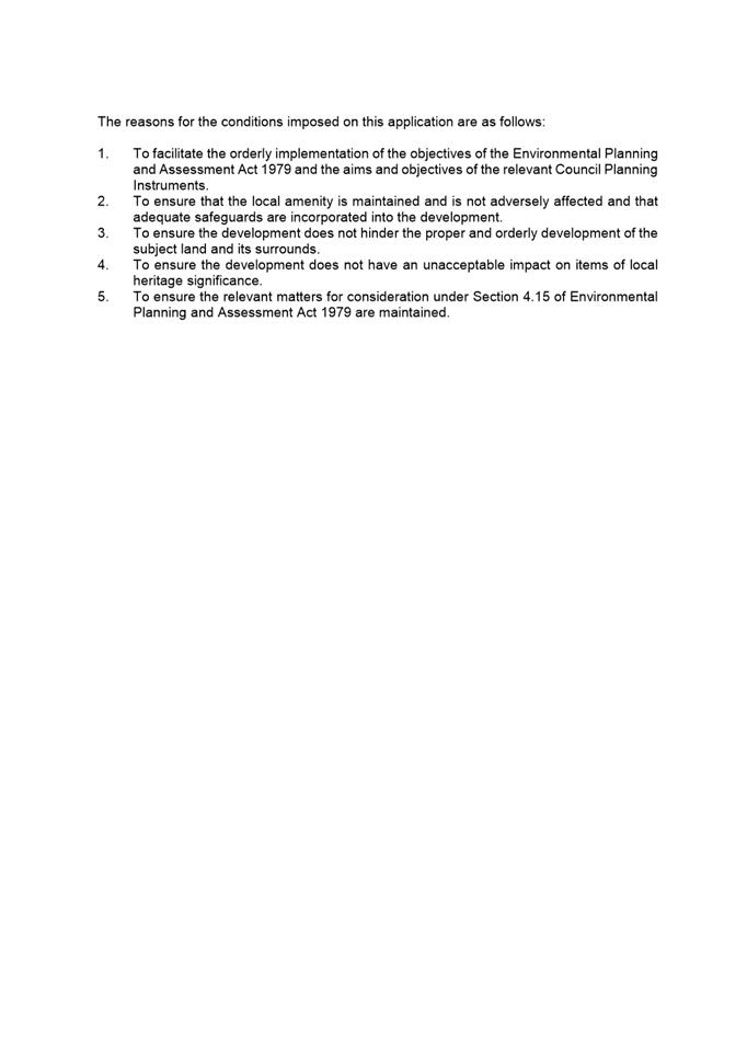
The reasons for the conditions imposed on this application are as follows:
1. To facilitate the orderly implementation of the objectives of the Environmental Planning and Assessment Act 1979 and the aims and objectives of the relevant Council Planning instrument.
2. To ensure that the local amenity is maintained and is not adversely affected and that adequate safeguards are incorporated into the development.
3. To ensure the development does not hinder the proper and orderly development of the subject land and its surrounds.
4. To ensure the relevant matters for consideration under Section 4.15 of Environmental Planning and Assessment Act 1979 are maintained.
|
Sohini Sen
Senior Development Assessment Officer
|
1⇩ |
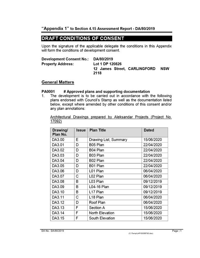
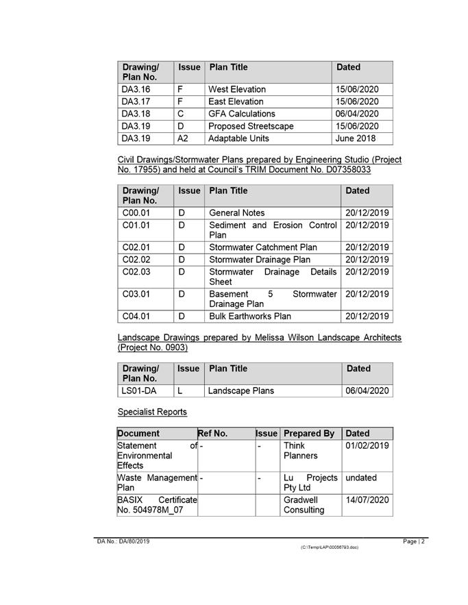
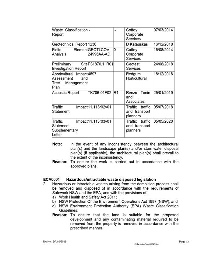
Attachment 1: Assessment Report & Conditions |
97 Pages |
|
|
2⇩ |
Attachment 2: Locality Map |
1 Page |
|
|
3⇩ |
Attachment 3: Plans used during assessment |
7 Pages |
|
|
Attachment 4: Internal plans used during assessment (confidential) |
13 Pages |
|
|
|
5⇩ |
Attachment 5: Clause 4.6 Statements used during assessment |
26 Pages |
|
REFERENCE MATERIAL
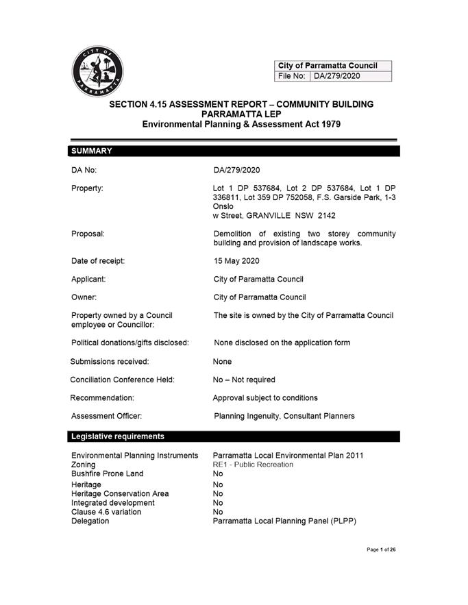
ITEM NUMBER 5.3
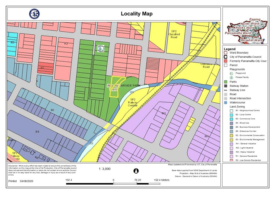
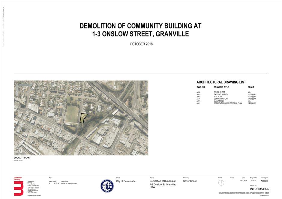
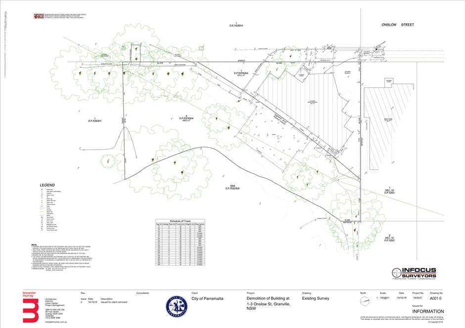
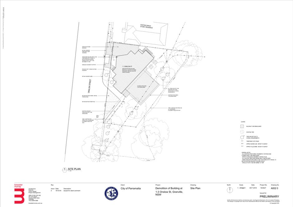
SUBJECT OUTSIDE PUBLIC MEETING: Garside Park, 1-3 Onslow Street, GRANVILLE NSW 2142 (Lots 1-2 DP 537684, Lot 1 DP 336811, Lot 359 DP 752058)
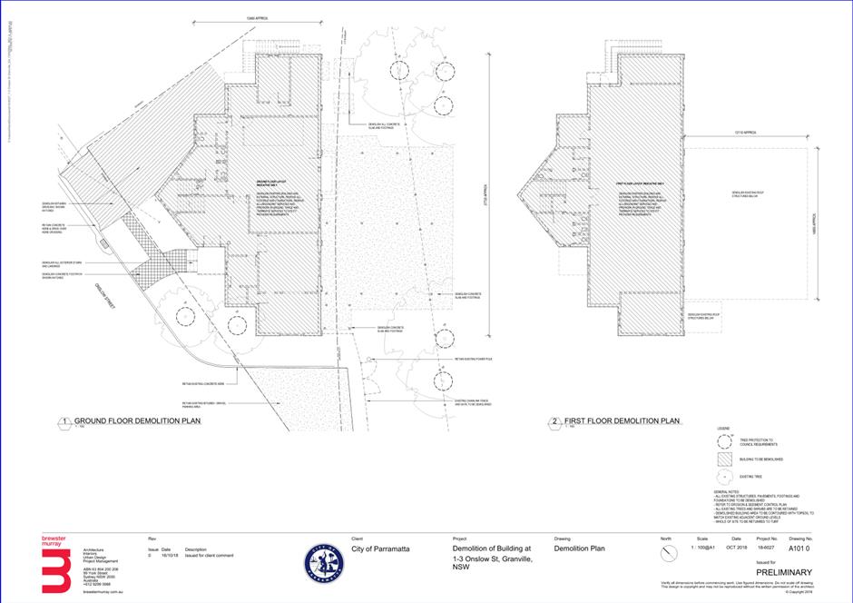
DESCRIPTION Demolition of existing two-storey community building and provision of landscape works.
REFERENCE DA/279/2020 -
APPLICANT/S City of Parramatta Council
OWNERS City of Parramatta Council
REPORT OF Group Manager Development and Traffic Services
|
This matter has received less than ten (10) unique submissions and will be considered outside of a public meeting as per Local Planning Panels Direction – Operational Procedures dated 30 June 2020 made under section 9.1 of the Environmental Planning and Assessment Act 1979.
DATE OF REPORT 18 AUGUST 2020
REASON FOR REFERRAL TO LPP
The application is referred to Parramatta Local Planning Panel for determination as the subject site is owned by the City of Parramatta Council.
EXECUTIVE SUMMARY
This is a summary of the full assessment of the application as outlined in Attachment 1, the Section 4.15 Assessment Report.
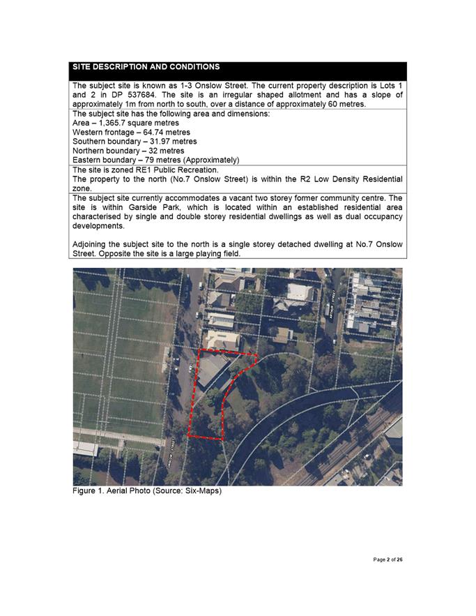
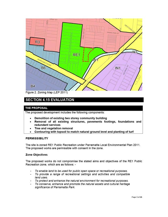
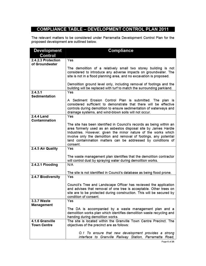
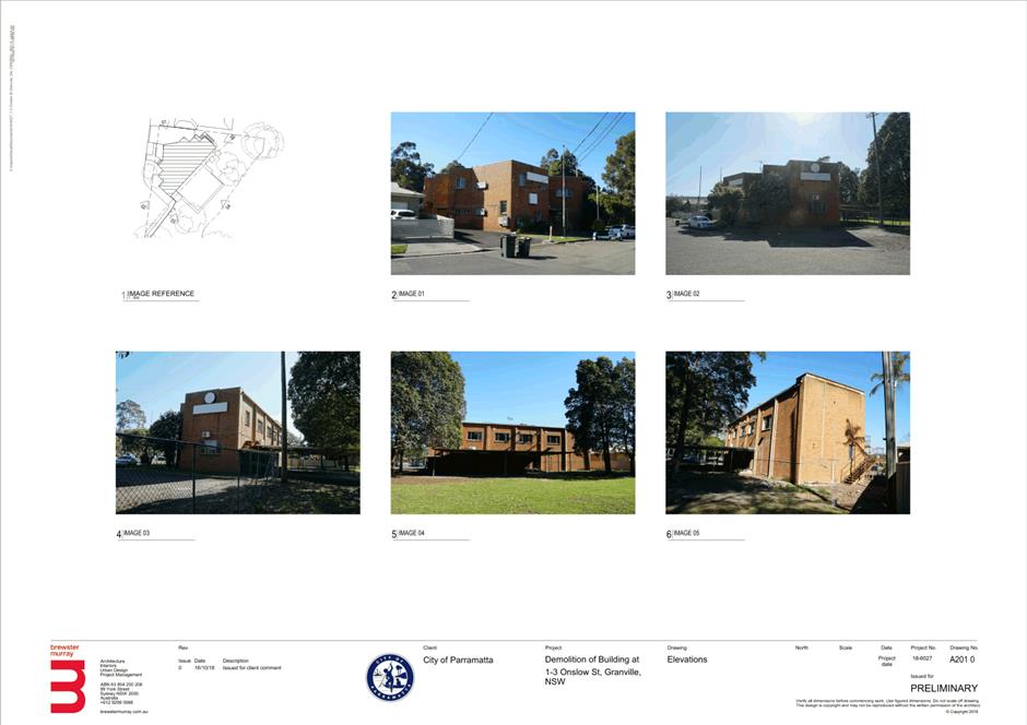
The Site The subject site is known as 1-3 Onslow Street and zoned RE1 Public Recreation. The site is an irregular shaped allotment with an overall site area of 1,365.7 square metres. The site is adjoinins R2 Low Density Reisidential land and dwelling houses to the north.
The subject site currently accommodates a vacant two storey former community centre. The site is within Garside Park, which is located within an established residential area characterised by single and double storey residential dwellings as well as dual occupancy developments.
Adjoining the subject site to the north is a single storey detached dwelling at No.7 Onslow Street and to the west is an exisitng playing field.
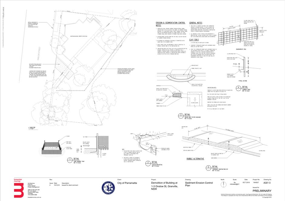
Proposed Development The proposal seeks consent for demolition of existing two storey community building, removal of all existing structures, pavements footings, foundations and redundant service, tree and vegetation removal, and contouring/earthworks with topsoil to match natural ground levels and facilitate planting of turf.
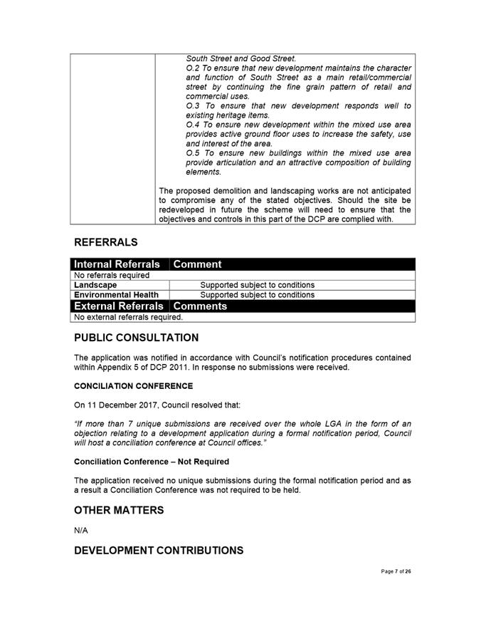
The proposal was reviewed by Council’s Landscape and Environmental Health Officers and no objections were raised subject to the imposition of appropriate conditions of consent.
The application was notified from 26 May – 10 June 2020. No submissions were received in response.
The proposal has been assessed in accordance with the matters for consideration outlined in Section 4.15(1) of the Environmental Planning and Assessment Act 1979. The proposed carport is consistent with the aims, objectives and controls of Parramatta Local Environmental Plan 2011 and Parramatta Development Control Plan 2011.
The proposal is permissible in the RE1 Public Recreation Zone and does not result in a development which is unsuitable within the context of the future desired character of the locality. A merit assessment of the proposal as a whole has determined that the proposal is satisfactory and does not result in unreasonable impacts to adjoining sites and locality. The proposal is suitable for the site and is in the public interest.
|
|
That the Parramatta Local Planning Panel (PLPP) exercising the functions of Council pursuant to Section 4.16 of the Environmental Planning and Assessment Act 1979 grant development consent to DA/279/2020 for the demolition of an existing two storey community building and provision of landscape work on land at Lot 1 DP 537684, Lot 2 DP 537684, Lot 1 DP 336811, Lot 359 DP 752058, F.S. Garside Park, 1-3 Onslow Street, GRANVILLE NSW 2142.
|
Wendy Wang
Team Leader Development Assessment
|
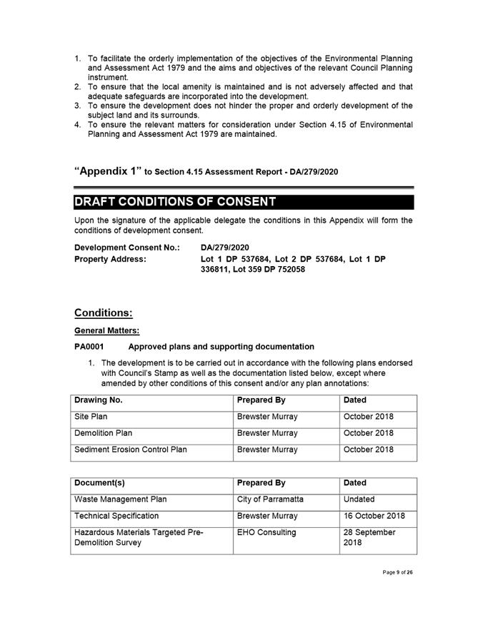
1⇩ |
Attachment 1: Assessment Report & Conditions |
26 Pages |
|
|
2⇩ |
Attachment 2: Locality Map |
1 Page |
|
|
3⇩ |
Attachment 3: Plans used during assessment |
6 Pages |
|
REFERENCE MATERIAL