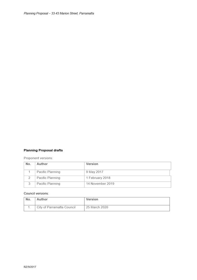
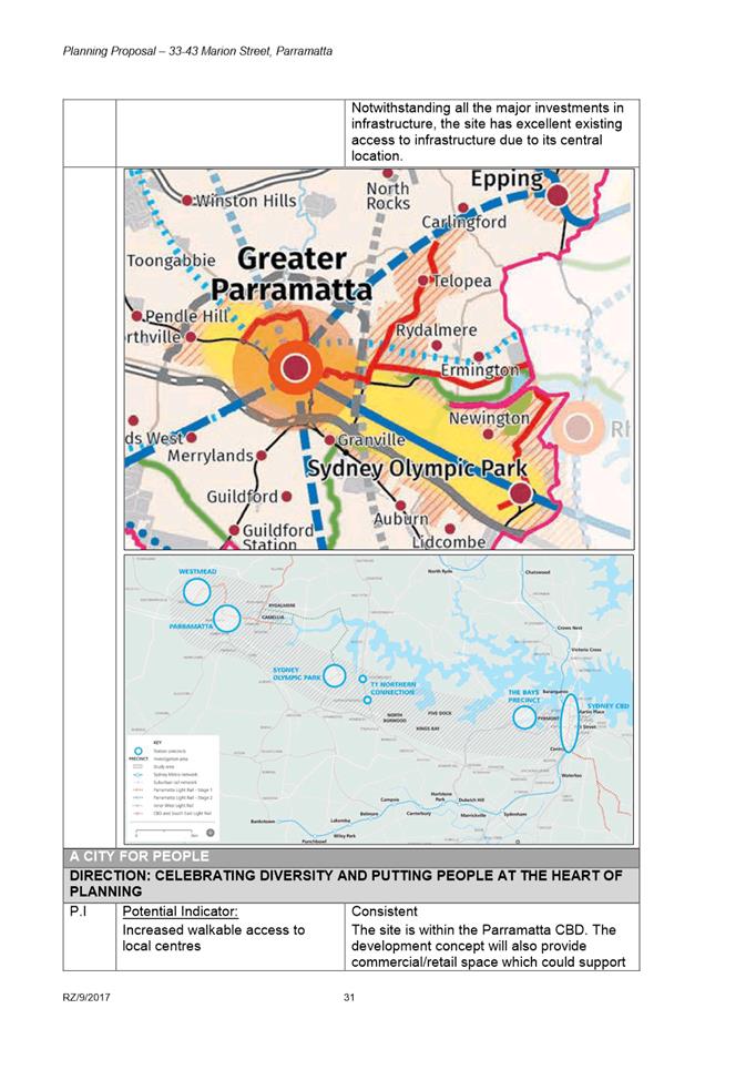
|
Item 5.1 - Attachment 1 |
Attachment 1: Assessment Report |
NOTICE OF Local Planning Panel MEETING
PUBLIC AGENDA
An Ordinary Local Planning Panel will be held remotely via audio-visual link, Tuesday, 21 July 2020 at 3.30pm.
Brett Newman
CHIEF EXECUTIVE OFFICER
THIS PAGE LEFT BLANK INTENTIONALLY
Local Planning Panel 21 July 2020
TABLE OF CONTENTS
ITEM SUBJECT PAGE NO
1 ACKNOWLEDGMENT OF THE TRADITIONAL LAND OWNERS
The City of Parramatta Council acknowledges the Burramattagal Clan of The Darug, the traditional land owners of Parramatta and pays its respects to the elders both past and present
2 WEBCASTING ANNOUNCEMENT
This public meeting will be recorded. The recording will be archived and available on Council’s website.
All care is taken to maintain your privacy; however if you are in attendance in the public gallery, you should be aware that your presence may be recorded.
3 APOLOGIES
4 DECLARATIONS OF INTEREST
5 Reports - Development Applications
5.1 25 Ray Road, Epping (Lot 2 DP 1180988)........................................... 6
5.2 36 Orchard Road, Beecroft (Lot 10 DP 31392)............................... 177
6.1 Post-exhibition: Planning Proposal, draft Development Control Plan and draft Planning Agreement for 33-43 Marion Street, Parramatta... 240
Development Applications
21 July 2020
5.1 25 Ray Road, Epping (Lot 2 DP 1180988).................................................... 6
5.2 36 Orchard Road, Beecroft (Lot 10 DP 31392)........................................ 177
Local Planning Panel 21 July 2020 Item 5.1
ITEM NUMBER 5.1
SUBJECT 25 Ray Road, Epping (Lot 2 DP 1180988)
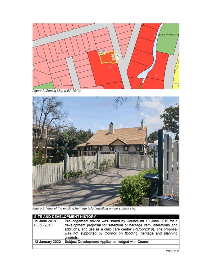
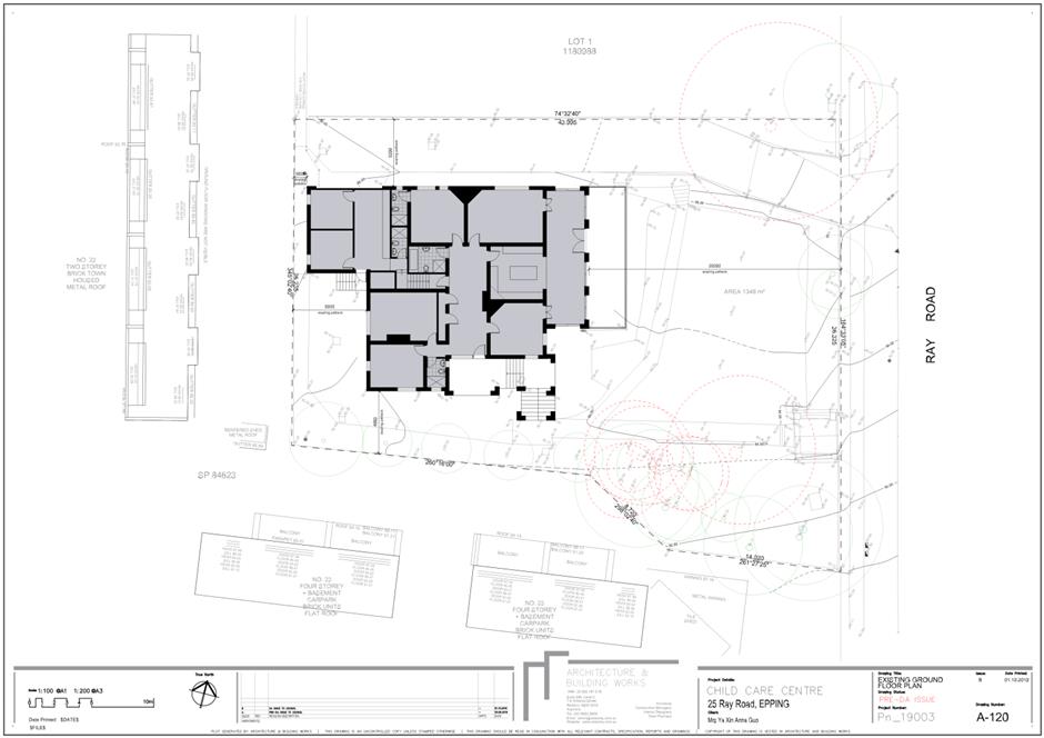
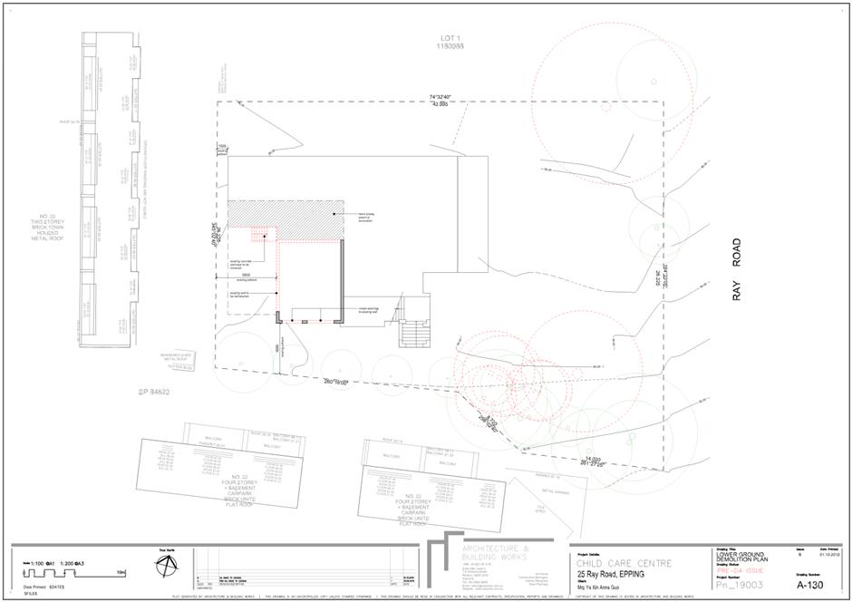
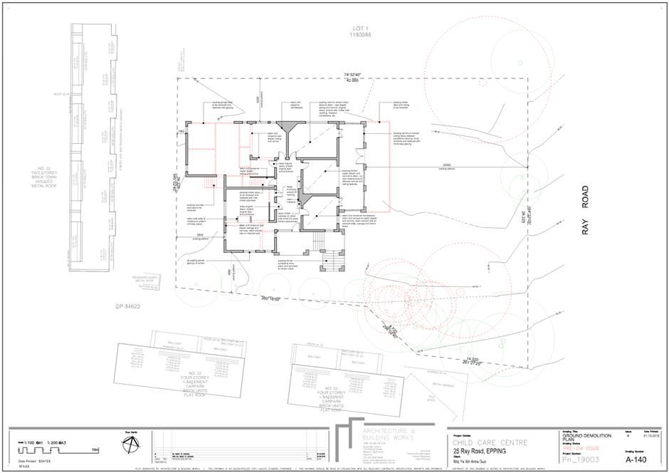
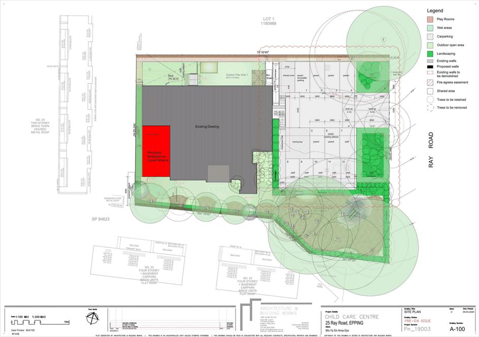
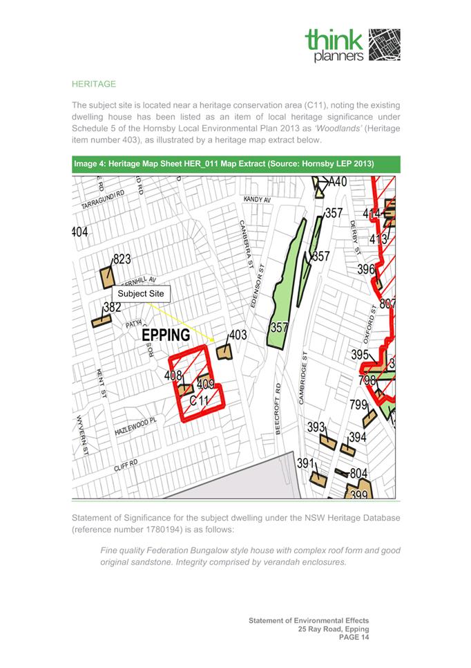
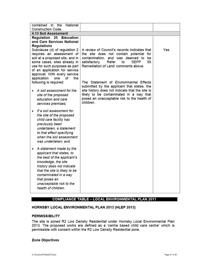
DESCRIPTION Tree removal, alterations and lower ground floor additions to convert an existing heritage listed item of local significance (‘Woodlands’) into a 50 place centre-based child care facility with new at-grade parking for 12 vehicles.
REFERENCE DA/19/2020 -
APPLICANT/S AB Works
OWNERS Ms Y X A Guo
REPORT OF Group Manager Development and Traffic Services
|
DATE OF REPORT - 21 JULy 2020
REASON FOR REFERRAL TO LPP
This application is referred to the Parramatta Local Planning Panel as more than ten submissions have been received in relation to the proposal.
EXECUTIVE SUMMARY
This is a summary of the full assessment of the application as outlined in Attachment 1, the Section 74.15 Assessment Report.
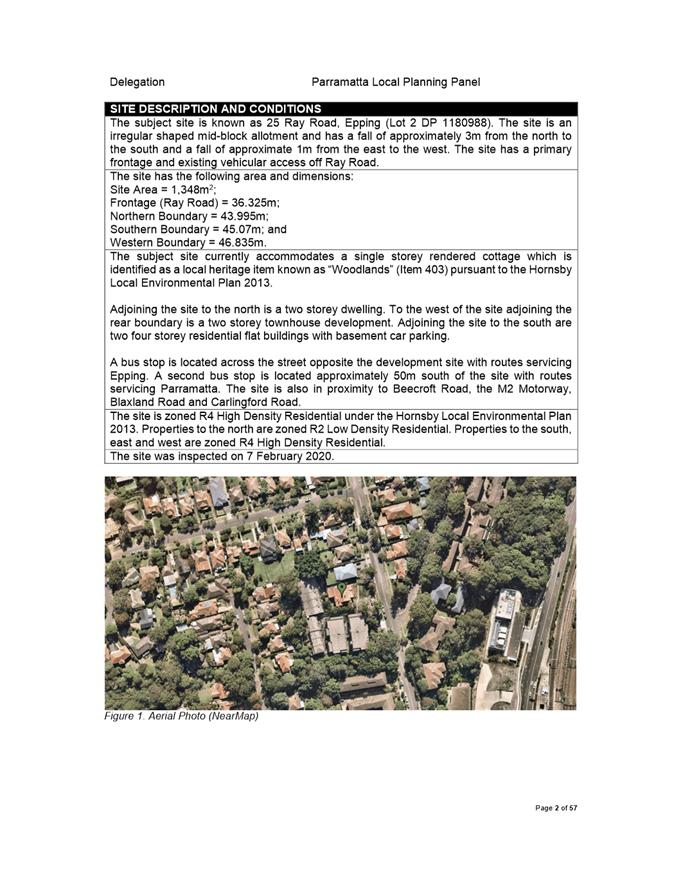
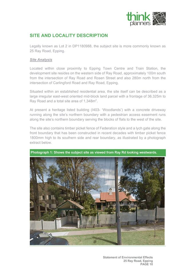
The Site The subject site is known as 25 Ray Road, Epping (Lot 2 DP 1180988). The site is an irregular shaped mid-block allotment and has a primary frontage and existing vehicular access off Ray Road. The site has an area of 1,348m2.
The subject site currently accommodates a single storey rendered cottage which is identified as a local heritage item known as “Woodlands” (Item 403) pursuant to the Hornsby Local Environmental Plan 2013. Adjoining the site to the north is a two storey dwelling. To the west of the site adjoining the rear boundary is a two storey townhouse development. Adjoining the site to the south are two four storey residential flat buildings with basement car parking.
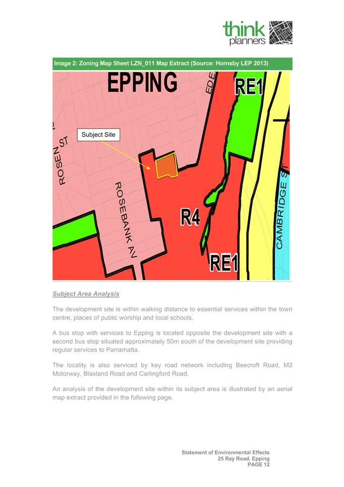
The site is zoned R4 High Density Residential under the Hornsby Local Environmental Plan 2013. Properties to the north are zoned R2 Low Density Residential. Properties to the south, east and west are zoned R4 High Density Residential
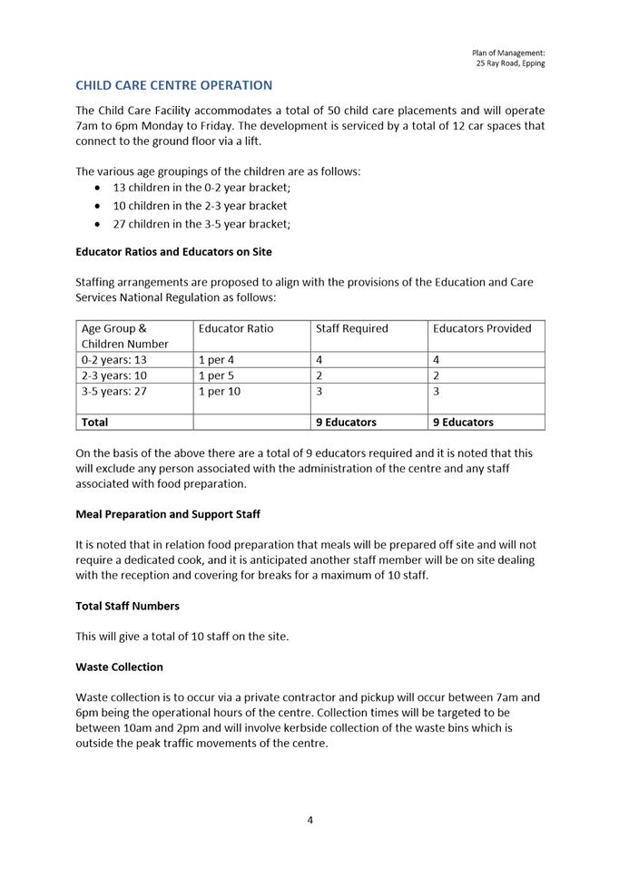
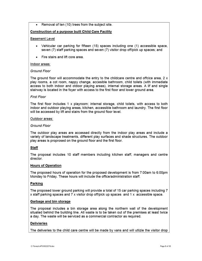
Proposed Development The proposed development includes the following components: · Removal of twelve trees; · Alterations and additions to the existing heritage listed dwelling; · Change of use of the existing dwelling to centre based child care facility for 50 children with at grade parking for 12 vehicles; · The proposed hours of operation are 7:00am until 6:00pm Monday to Friday.
Amended plans were submitted during the course of assessment of this application. The amended plans are subject of this assessment.
The proposal was referred to Council’s Development Engineer, Heritage Advisor, Traffic Engineer, Landscape and Tree Officer, Social Outcomes Officer and Environmental Health Officer. Concerns were raised by Council’s Development Engineer, Heritage Advisor, Landscape and Tree Officer, and Social Outcomes Officer who requested amendments to the proposal.
The application was notified in accordance with Council’s notification procedures contained within DCP 2013. In response 26 unique submissions were received. The issues raised within those submissions are addressed within the assessment report.
On 11 December 2017, Council resolved that:
“If more than 7 unique submissions are received over the whole LGA in the form of an objection relating to a development application during a formal notification period, Council will host a conciliation conference at Council offices”.
The application received 26 unique submissions during the formal notification period and as a result a Conciliation Conference was required to be held. In this instance, the application is recommended for refusal. Furthermore, Council’s Crisis Management Team suspended all Conciliation Meetings from 25 March 2020, for the foreseeable future, due to COVID19 and maintaining social distancing requirements. Therefore, a conciliation meeting in accordance with Council’s resolution was not required to be held for this application.
Amended plans and documentation were submitted during the course of assessment including:
· Amended architectural plans submitted with changes to the internal layout and deletion of one car parking space; · Amended traffic impact assessment report; · Amended landscape plan; · Amended Arborist report; · Amended flood impact assessment; · Amended stormwater plans; · Amended heritage impact assessment; and · Amended Statement of Environmental Effects.
In accordance with Clause 5.5.9 of Council’s notification procedures entitled “Notifications of Amended Development Applications Where The Development Is Substantially Unchanged” the application did not require re-notification as the amended application is considered to be substantially the same development and does not result in a greater environmental impact.
Council’s Heritage Advisor raised objections with the amended proposal. The key issues of the development proposal include site suitability, impacts to the heritage item on site and parking.
The proposal has been assessed in accordance with the matters for consideration outlined in Section 4.15(1) of the Environmental Planning and Assessment Act 1979. The proposed child care centre is inconsistent with the aims, objectives and controls of the Child Care Guidelines 2017, Hornsby Local Environmental Plan 2013 and Hornsby Development Control Plan 2013.
The proposal is permissible in the R4 High Density Residential Zone however results in a development which is unsuitable within the context of the future desired character of this locality. A merit assessment of the proposal as a whole has determined that the proposal is unsatisfactory and results in unreasonable impacts to adjoining properties and the locality. The proposal is unsuitable for the site and is not in the public interest. |
|
RECOMMENDATION
(a) That Parramatta Local Planning Panel refuse development consent to DA/19/2020 for tree removal, alterations and lower ground floor additions to convert an existing heritage listed item of local significance (‘Woodlands’) into a 50 place centre-based child care facility with new at-grade parking for 12 vehicles at 25 Ray Road, Epping subject to the following reasons:
Heritage Impacts
1. The proposed development does not exhibit a satisfactory proposal, in that it is inconsistent with the following provisions prescribed within Hornsby Local Environmental Plan 2013: i) Clause 2.3 - the development is inconsistent with the zone objectives of the R4 General Industrial zone. ii) Clause 5.10 – the development is inconsistent with the objectives of Clause 5.10 Heritage Conservation.
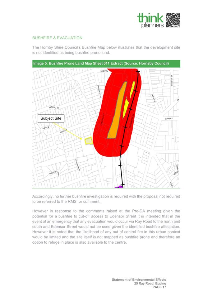
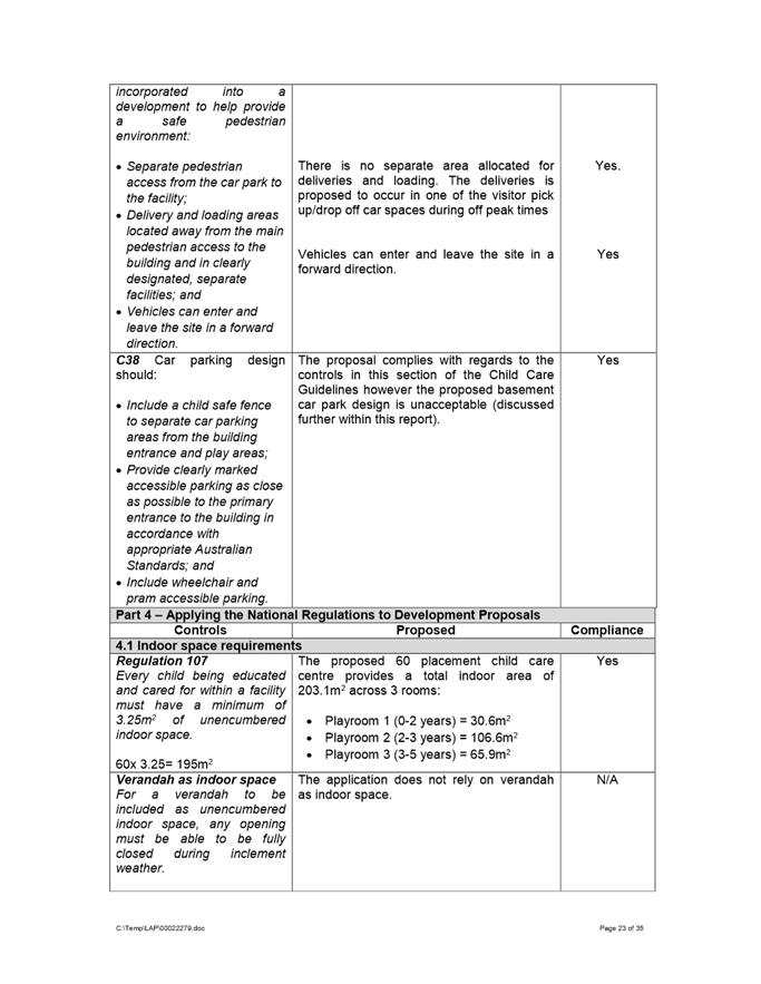
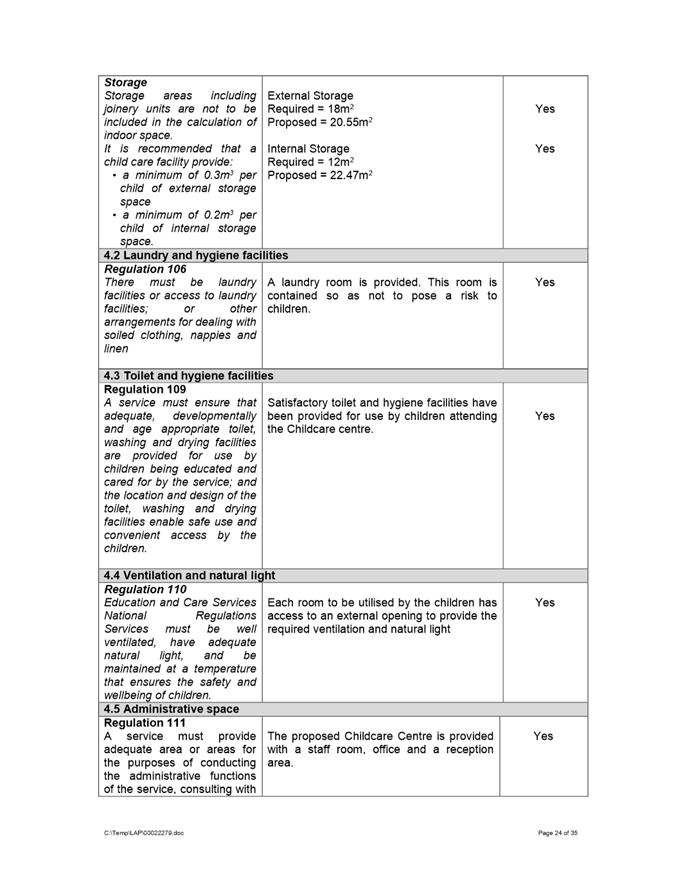
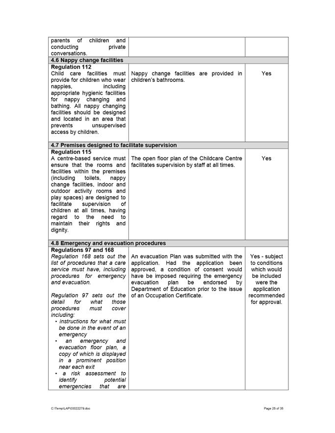
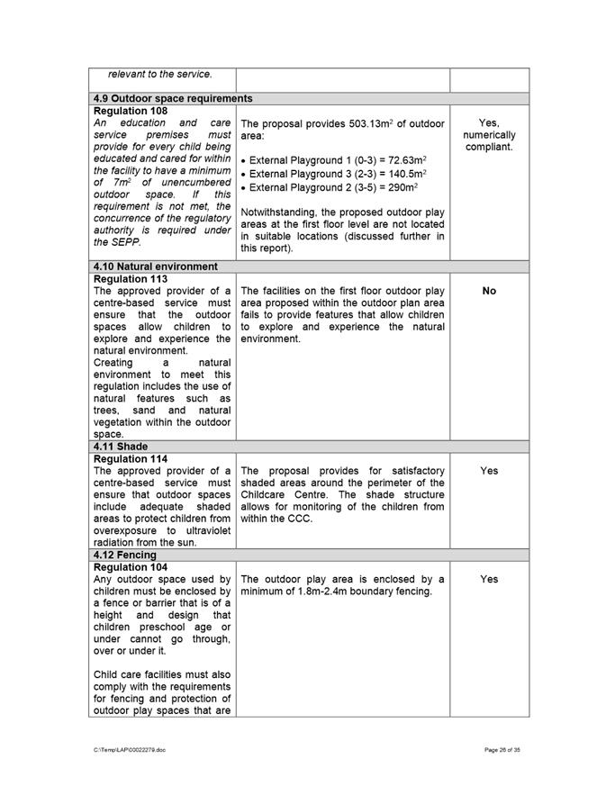
2. The proposed development does not exhibit a satisfactory proposal, in that it is inconsistent with the following provisions prescribed within the Childcare Planning Guideline: i) Part 3.1 Site Selection and Location a. C2 – Suitability of Site ii) Part 3.2 Local Character, Streetscape and Public Domain Interface a. C5 – Local Character and Streetscape b. C9 – Fencing c. C15 – Built Form Character iii) Part 3.3 Landscaping a. C19 – Car Parking Landscape Design iv) Part 4.8 Emergency and Evacuation Procedures a. C1 – Emergency and Evacuation Procedures
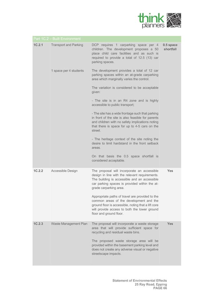
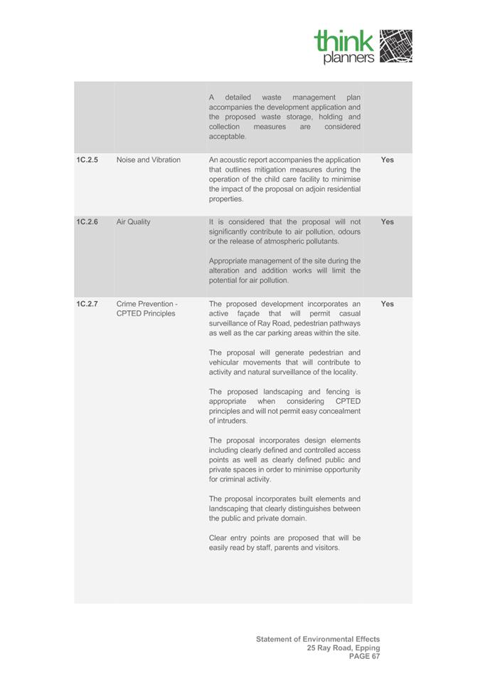
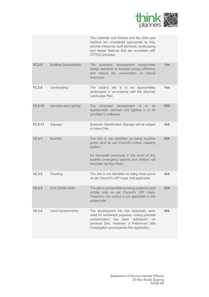
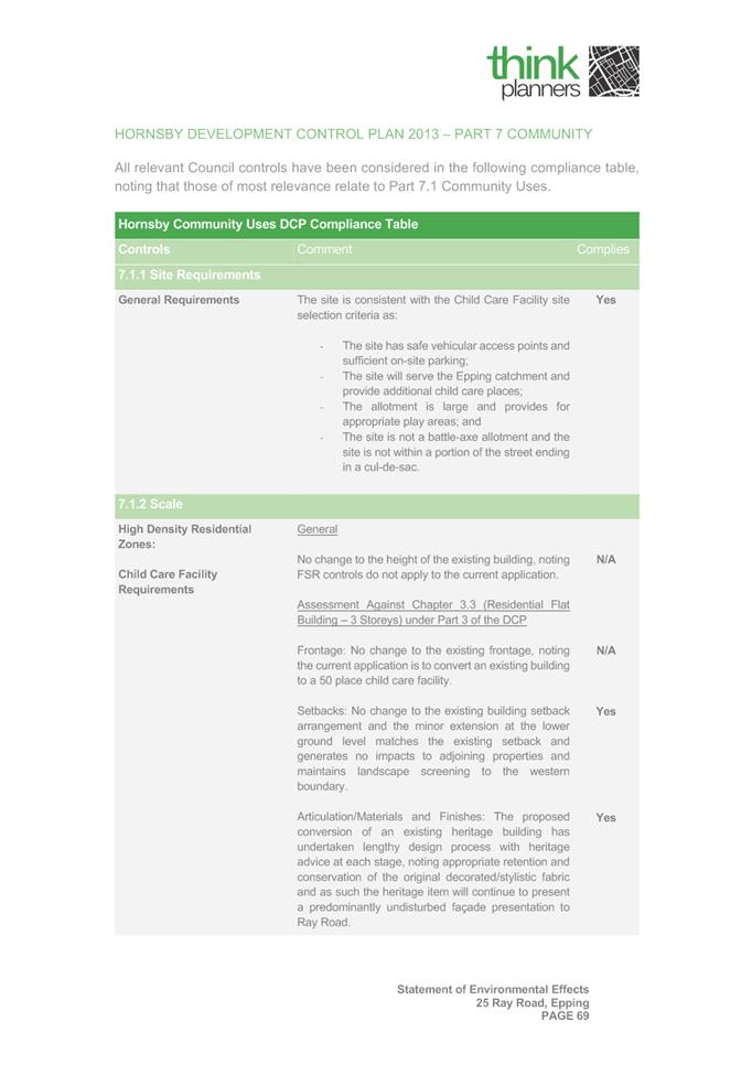
3. The proposed development does not exhibit a satisfactory proposal, in that it is inconsistent with the following provisions prescribed within the Hornsby Development Control Plan 2013: i) Section 1C.2.5 Noise and Vibration ii) Section 3.1.3 Landscaping iii) Section 7.1.4 Landscaping iv) Section 7.1.5 Open Space
Traffic and Parking
4. The proposed development does not exhibit a satisfactory proposal, in that it is inconsistent with the following provisions prescribed within the Childcare Planning Guideline: i) Part 3.8 Traffic, Parking and Circulation b. C31 – Parking
5. The proposed development does not exhibit a satisfactory proposal, in that it is inconsistent with the following provisions prescribed within the Hornsby Development Control Plan 2013: i) Section 1C.2.1 Transport and Parking ii) Section 7.1.7 Vehicle Access and Parking
6. The proposed development does not exhibit a satisfactory proposal, in that it is inconsistent with the following provisions prescribed within the Auburn Development Control Plan 2012 – Parking and Loading: i) Section 8.1 – Child Care Centres a. D1 – Parking Rates b. D6 Bicycle Parking
Insufficient Information
7. The applicant has failed to submit sufficient details to Council. The following documents were insufficient:
i) Emergency Evacuation Plan ii) Car Parking Demand Assessment
Accordingly, the proposal fails to satisfy Section 4.8 – Emergency and Evacuation Procedures within the Childcare Planning Guideline, Section 1C.2.1 Transport and Parking within the Hornsby Development Control Plan 2013, and Section 4.15(b),(c) & (e) of the Environmental Planning and Assessment Act, 1979,
8. The proposal fails to satisfy the relevant considerations under Section 4.15(1)(c) Environmental Planning and Assessment Act 1979 for built environment, suitability of the site, and the public interest.
9. The proposal fails to satisfy the relevant considerations under Section 4.15(1)(e) Environmental Planning and Assessment Act 1979 in that the adverse impacts generated by the development due to non-compliances with the applicable planning controls is not beneficial for the local community and as such, is not in the wider public interest.
(b) Further. that submitters be advised of the decision. |
Sohini Sen
Senior Development Assessment Officer
|
1⇩ |
Attachment 1: Assessment Report |
57 Pages |
|
|
2⇩ |
Attachment 2: Locality Map |
1 Page |
|
|
3⇩ |
Attachment 3: Architectural Plans |
11 Pages |
|
|
4⇩ |
Attachment 4: Statement of Environmental Effects |
79 Pages |
|
|
5⇩ |
Attachment 5: Plan of Management |
18 Pages |
|
REFERENCE MATERIAL
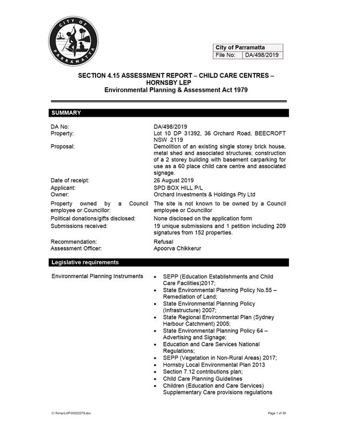
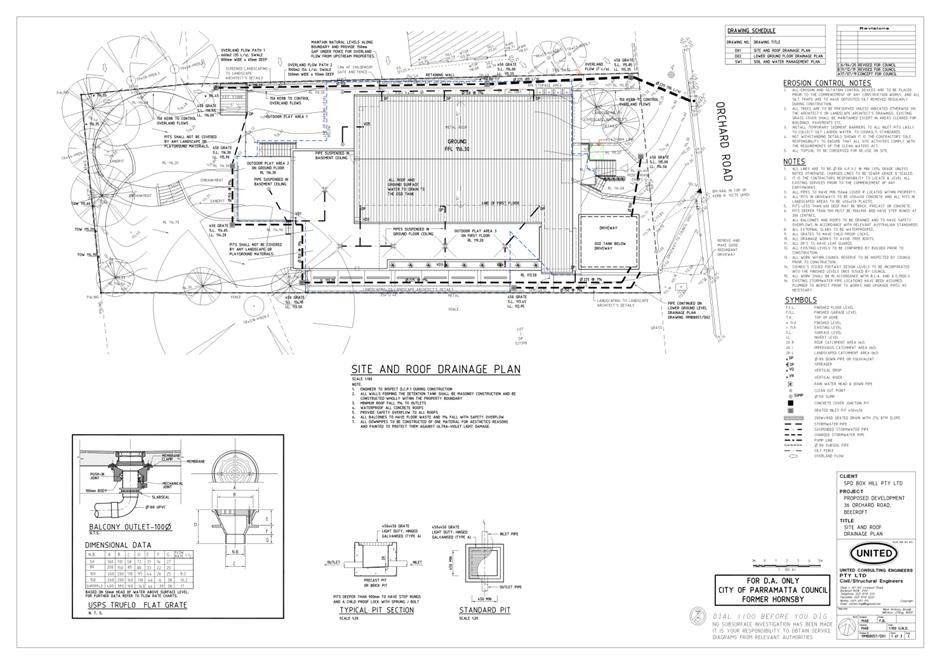
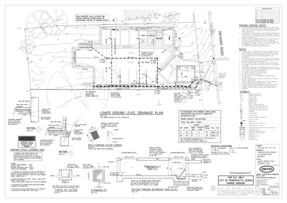
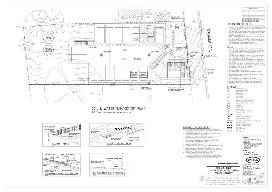
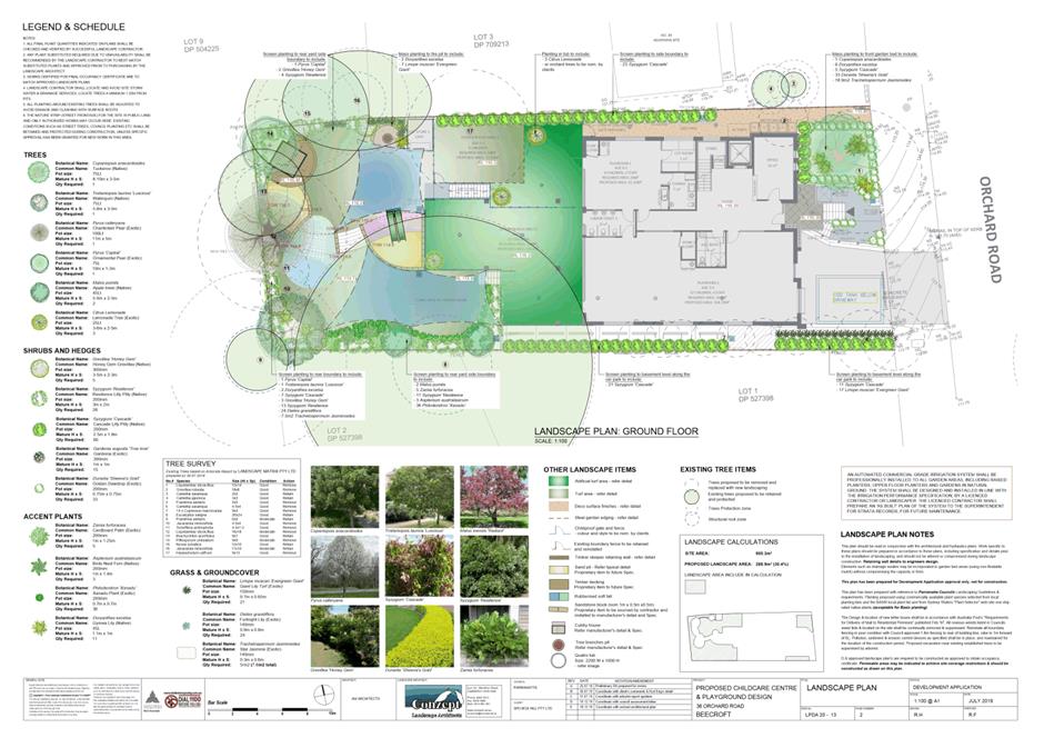
ITEM NUMBER 5.2
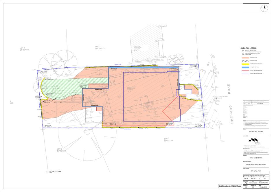
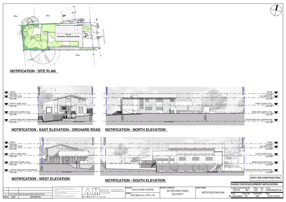
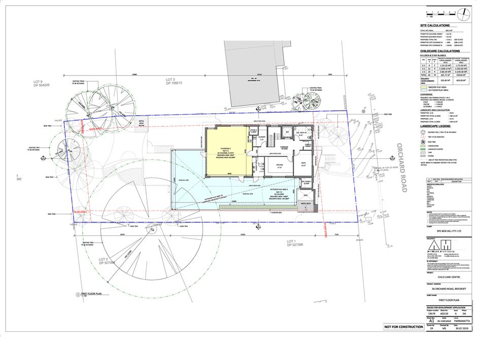
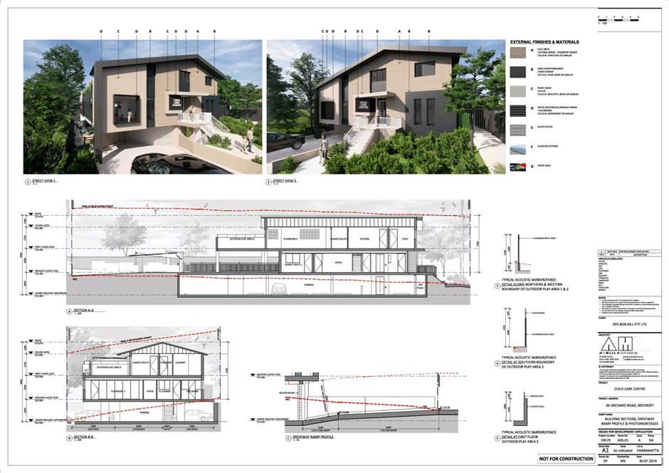
SUBJECT 36 Orchard Road, Beecroft (Lot 10 DP 31392)
DESCRIPTION Demolition of existing structures, tree removal and construction of a double-storey 60 place child care centre including basement car parking and associated business identification signage.
REFERENCE DA/498/2019 -
APPLICANT/S SPD BOX HILL P/L
OWNERS Orchard Investments & Holdings P/L
REPORT OF Group Manager Development and Traffic Services
|
DATE OF REPORT 15 June 2020
REASON FOR REFERRAL TO LPP
The application is referred to Parramatta Local Planning Panel due to the number of submissions (19 unique submissions and 1 petition including 209 signatures from 152 properties).
EXECUTIVE SUMMARY
This is a summary of the full assessment of the application as outlined in Attachment 1, the Section 4.15 Assessment Report.
Site
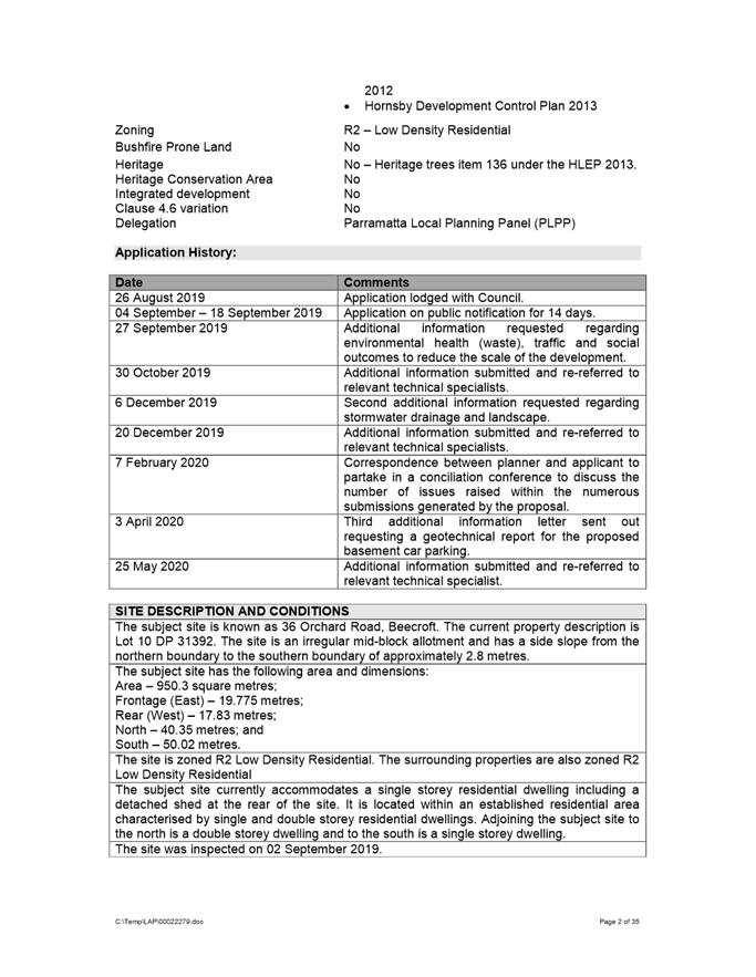
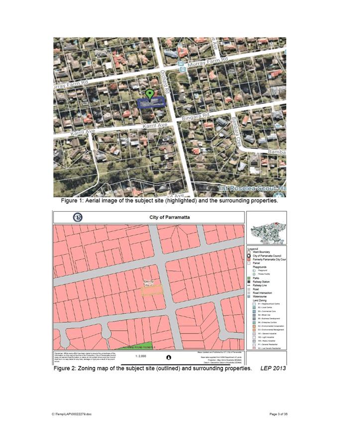
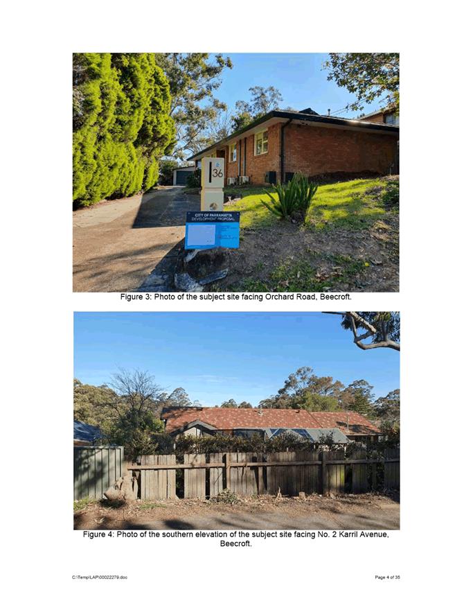
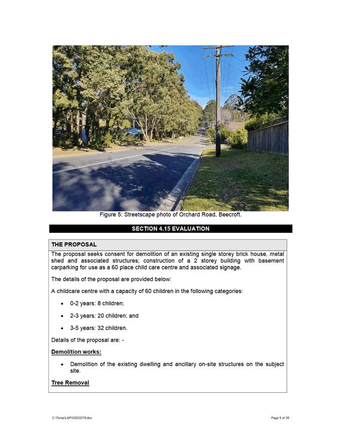
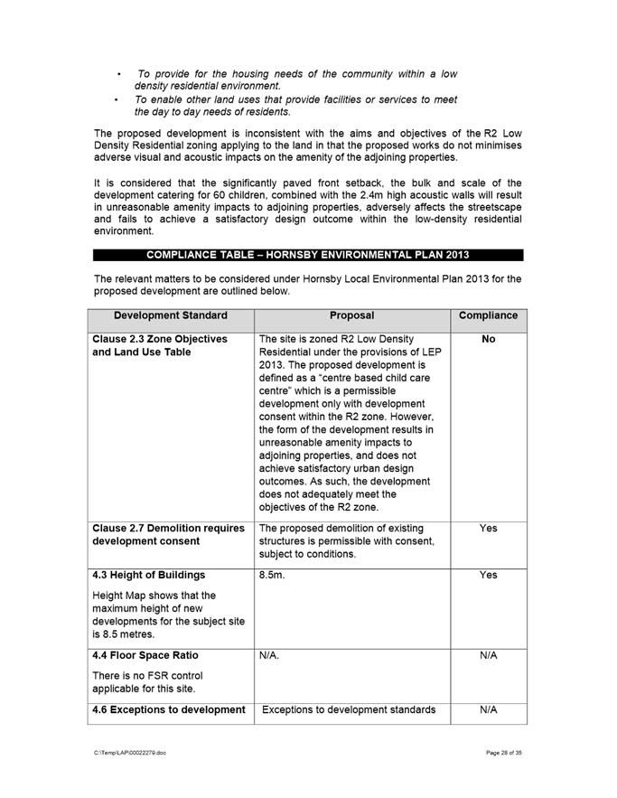
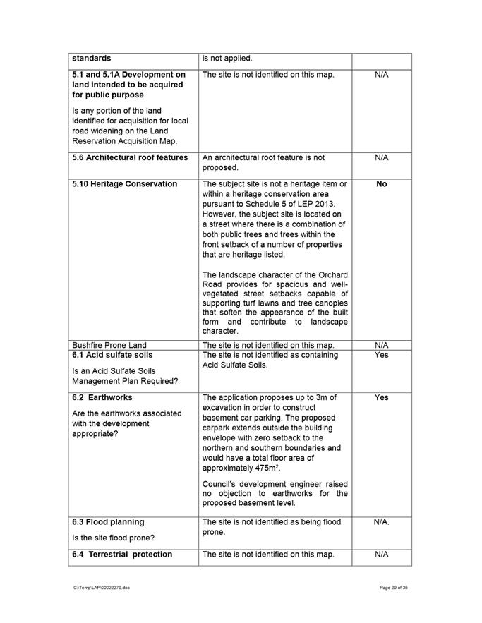
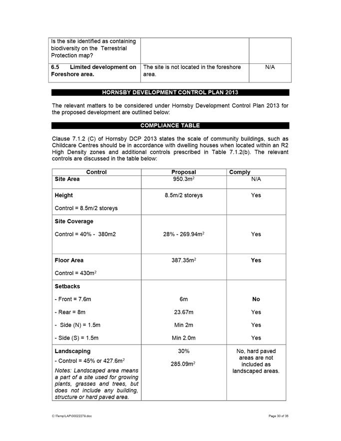
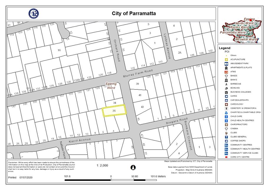
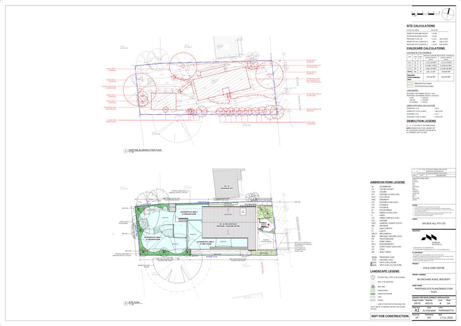
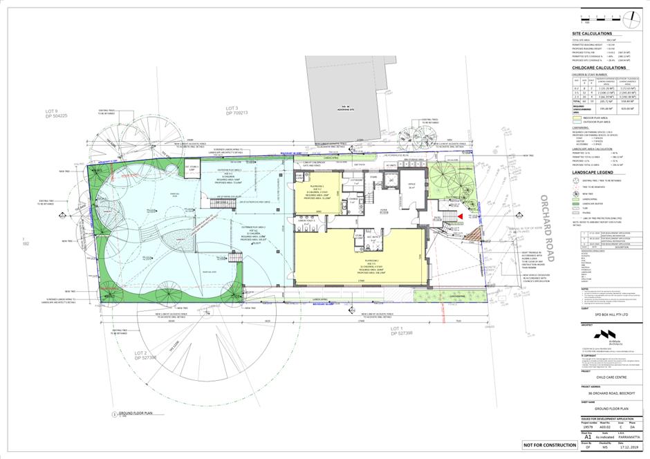
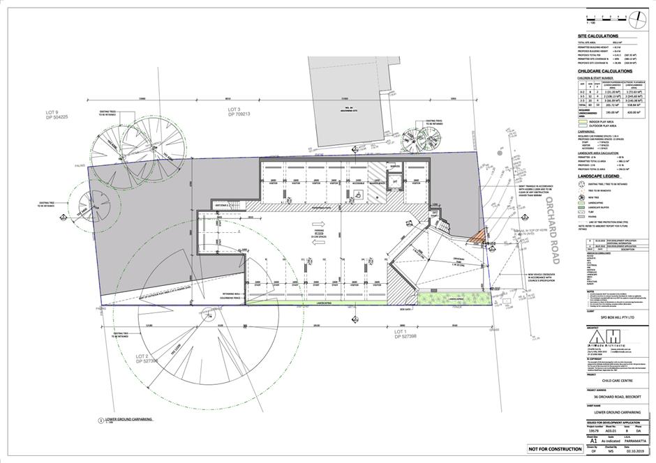
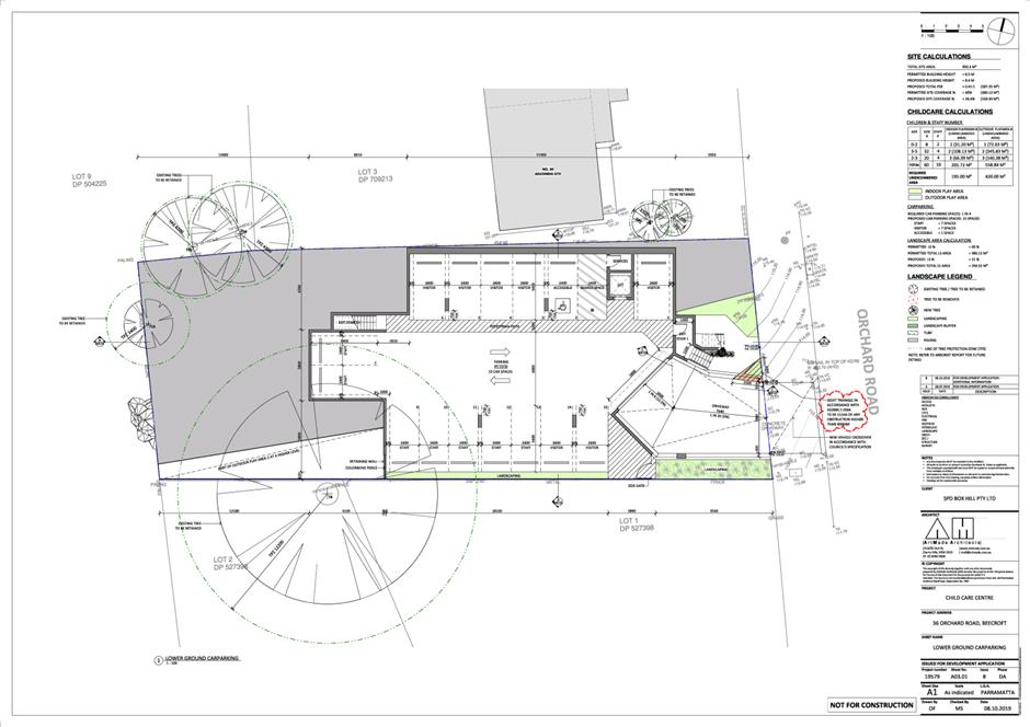
The subject site is known as 36 Orchard Road, Beecroft. The current property description is Lot 10 DP 31392. The site is an irregular mid-block allotment and has a side slope from the northern boundary to the southern boundary of approximately 2.8 metres. The site has an area of 950.3m2. The site is zoned R2 Low Density Residential. The surrounding properties are also zoned R2 Low Density Residential. The subject site currently accommodates a single storey residential dwelling including a detached shed at the rear of the site. It is located within an established residential area characterized by single and double storey residential dwellings. Adjoining the subject site to the north is a double storey dwelling and to the south is a single storey dwelling.
Proposed development
The proposed development includes the following components:
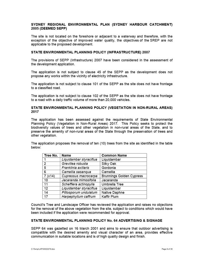
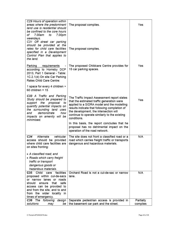
· Demolition of existing structures; · Removal of 10 trees; and · Construction of a double storey childcare centre with basement car parking for 15 vehicles including 1 accessible space.
The centre is proposed to cater for a maximum of 60 children and 10 staff. The proposed hours of operation are 7:00am until 6:00pm, Monday to Friday.
The proposal was referred to Council’s Development Engineer, Building Surveyor, Traffic Engineer, Landscape and Tree Officer, Social Outcomes Officer and Environmental Health Officer for review.
The application was notified and advertised to the adjoining and nearby properties from 4 September to 18 September 2019 in accordance with Council’s notification procedures contained within Appendix 5 of DCP 2013. A total of nineteen (19) unique submissions from individual properties and 1 petition including a total of 209 signatures from 152 properties was received in response. Issues raised in the submission relate to increased traffic congestion and safety of pedestrians and motorists, noise pollution, decrease in value of homes, other child care centres nearby, out of character with the streetscape, excessive number of children, inappropriate hours of operation, insufficient on-site parking provision, overdevelopment of the site, inappropriate change of use from residential to commercial use and non-compliant front and side setbacks.
On 11 December 2017, Council resolved that:
“If more than 7 unique submissions are received over the whole LGA in the form of an objection relating to a development application during a formal notification period, Council will host a conciliation conference at Council offices.”
Given the number of submissions received, a Conciliation Conference was required to be held. The applicant elected not to attend a Conciliation Conference and therefore one was not held.
The proposal has been assessed in accordance with the matters for consideration outlined in Section 4.15(1) of the Environmental Planning and Assessment Act 1979. The proposed child care center is inconsistent with the aims, objectives and controls of the Child Care Guidelines 2017, Hornsby Local Environmental Plan 2013 and Hornsby Development Control Plan 2013.
Whilst purpose built child care centres are permissible with consent within the R2 Low Density Residential zoning that applies to the site, the proposal results in a development which is unsuitable within the context of the future desired character of this locality. A comprehensive merit assessment of the proposal has been undertaken and it has been determined that the proposal is unsatisfactory and results in unreasonable impacts to adjoining properties and the locality. The proposal is unsuitable for the site and is not in the public interest.
|
|
|
|
a) That Parramatta Local Planning Panel, exercising the functions of Council as the consent authority pursuant to the provisions of 4.16(1)(b) of the Environmental Planning and Assessment Act, 1979, refuse development consent to DA/498/2019 for demolition of existing structures, site consolidation, tree removal and construction of a 60 place childcare centre at 36 Orchard Road, Beecroft for the following reasons:
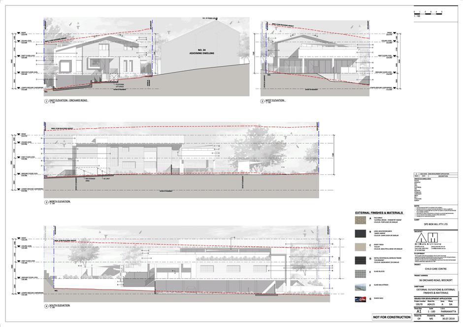
1. Pursuant to Section 4.15(1)(a)(i) of the Environmental Planning and Assessment Act, the proposal is inconsistent with the objectives of the R2 Zone of HLEP 2013 as the built form is of a bulk and scale that results in unreasonable amenity impacts to adjoining properties, adversely impacts on the streetscape and does not achieve satisfactory urban design outcomes.
2. Pursuant to Section 4.15(1)(a)(i) of the Environmental Planning and Assessment Act 1979, the proposal fails to comply with Clause 23 of State Environmental Planning Policy (Educational Establishments and Childcare Facilities) 2017 and the Child Care Planning Guideline 2017 as:
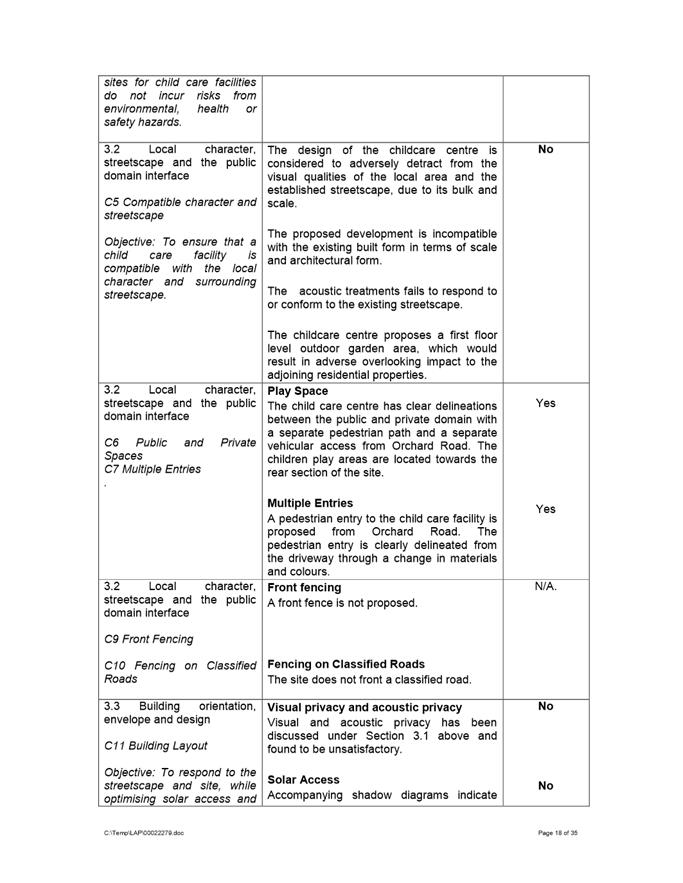
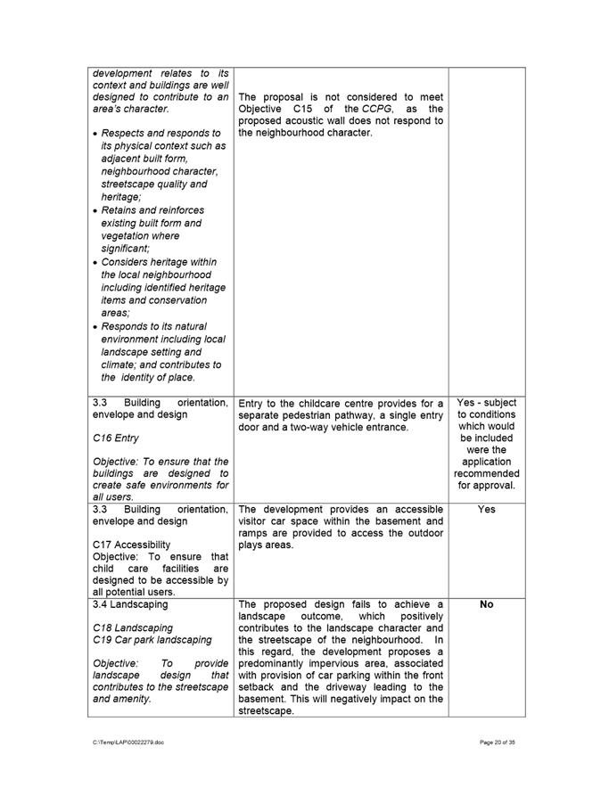
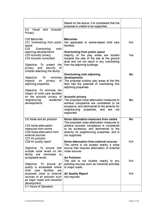
o 3.1 The proposal is contrary to the planning objectives within Part 1.3 of the Guideline in that the proposal is not compatible within the existing streetscape and the proposal does not adequately minimise adverse impacts on adjoining properties and the neighbourhood. o 3.2 The proposal is contrary to the design principles of Part 2 of the Guideline in relation to context, built form, landscaping, amenity and safety. o 3.3 The proposal is contrary to the Part 3 considerations of the guideline with respect to Part 3.2 Local Character, Streetscape and the public domain interface, Part 3.3 Building Orientation, Envelope and Design, Part 3.4 Landscaping, Part 3.5 Visual and Acoustic Privacy and Part 3.6 Noise and Pollution. 3. Pursuant to Section 4.15(1)(a)(iii) of the Environmental Planning and Assessment Act 1979, the proposal does not comply with the desired outcomes or the prescriptive measures of the Hornsby Development Control Plan 2013 in respect to Part 7.1.3 Setbacks.
4. Pursuant to Section 4.15(1)(b) of the Environmental Planning and Assessment Act 1979, the development would result in an adverse environmental and amenity impact on the surrounding built environment as the proposal would result in adverse visual and acoustic impacts, overshadowing impacts and not be consistent with the existing streetscape.
5. Pursuant to Section 4.15(1)(e) of the Environmental Planning and Assessment Act 1979, the development would not be in the public interest as the proposal is contrary to the local planning controls.
b) Further, that the submitters be advised of the Panel’s decision.
|
Apoorva Chikkerur
Development Assessment Officer
|
1⇩ |
Attachment 1: Assessment Report |
35 Pages |
|
|
2⇩ |
Attachment 2: Locality Map |
1 Page |
|
|
3⇩ |
Attachment 3: Plans used during assessment |
14 Pages |
|
|
4⇩ |
Attachment 4: Drainage Plans |
3 Pages |
|
|
5⇩ |
Attachment 5: Landscape Plans |
4 Pages |
|
REFERENCE MATERIAL
Innovative
21 July 2020
6.1 Post-exhibition: Planning Proposal, draft Development Control Plan and draft Planning Agreement for 33-43 Marion Street, Parramatta..................... 240
Local Planning Panel 21 July 2020 Item 6.1
ITEM NUMBER 6.1
SUBJECT Post-exhibition: Planning Proposal, draft Development Control Plan and draft Planning Agreement for 33-43 Marion Street, Parramatta
REFERENCE RZ/9/2017 - D07390080
REPORT OF Project Officer, Land Use Planning
|
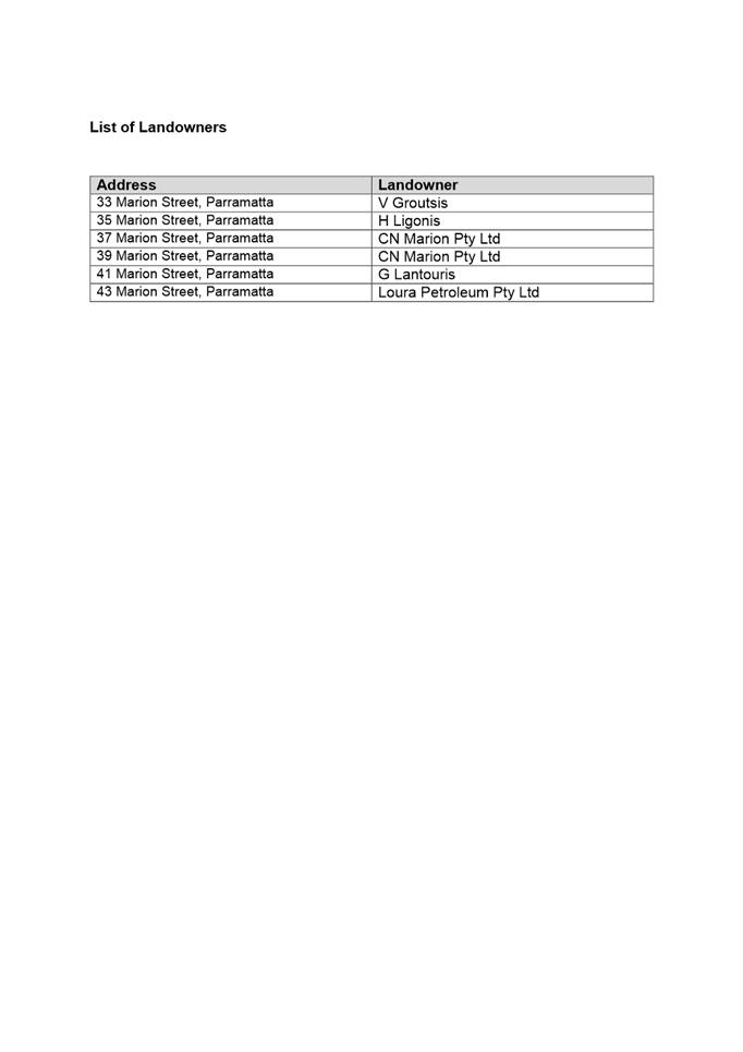
Landowner Multiple landowners (details provided in Attachment 5)
applicant Pacific Planning Pty Ltd
PURPOSE: The purpose of this report is to seek the Local Planning Panel’s advice to Council on the outcome of the public exhibition of the Planning Proposal, draft site-specific Development Control Plan and draft Planning Agreement for land at 33-43 Marion Street, Parramatta. |
|
That the Local Planning Panel consider the following Council officer recommendation in the Panel’s advice to Council:
(a) That Council notes the submissions made during the public exhibition of the Planning Proposal, draft site-specific Development Control Plan and draft Planning Agreement at 33-43 Marion Street, Parramatta, a summary of which is provided at Attachment 1.
(b) That Council endorse for finalisation the Planning Proposal for land at 33-43 Marion Street (provided at Attachment 2) which seeks to amend Parramatta Local Environmental Plan 2011 by way of: i. Increasing the height of buildings control from 12 metres to 80 metres; ii. Increasing the floor-space ratio (FSR) control from 2:1 to 6:1 (6.9:1 with design excellence bonus); iii. De-listing the heritage item at 37 Marion Street, Parramatta; iv. Including a site-specific provision which allows for an additional 5 percent FSR bonus where the development achieves certain high performing building criteria; and v. Including a site-specific provision to require satisfactory arrangements for the provision of state infrastructure, as required by the Department of Planning, Industry and Environment subject to the Planning Proposal being amended to apply maximum car parking rates in accordance with the Parramatta CBD Strategic Transport Study.
(c) That Council forward the Planning Proposal to the Department of Planning, Industry and Environment for finalisation and request that the final notification only be undertaken once Council confirms that the Planning Agreement has been signed and entered into.
(d) That Council endorse for finalisation the site-specific Development Control Plan contained at Attachment 3 for insertion in Section 4.3.3 – Parramatta City Centre of Parramatta Development Control Plan 2011, noting amendments included in the attached Draft DCP relating to design controls for the through-site link following public exhibition.
(e) That Council delegate authority to the Chief Executive Officer to finalise the draft Planning Agreement after considering the amendments requested by the applicant but seeking to ensure that the final Planning Agreement satisfies the following principles: i. That the Planning Agreement be substantially the same as the exhibited version (at Attachment 4) ii. That Community Infrastructure be levied against all residential uplift that has been facilitated by the Planning Proposal iii. That if the development proposes a primarily residential development and any ancillary commercial development on this site is less than the current 2:1 base FSR then the commercial floor space provided should have no impact on the calculation of the community infrastructure payable. iv. If the development proposed is a mixed-use development and the development provides commercial floor space greater than the 2:1 base FSR or entirely commercial development then no community infrastructure should be charged for any commercial floor space exceeding the 2:1 base FSR on this site. (Note community infrastructure is not applied to any base FSR regardless of the use of this floor space). v. That Community Infrastructure not be levied against any bonuses achieved under the Parramatta LEP 2011 (such as design excellence and high performing buildings) or another Environmental Planning Instruments (such as Affordable Rental Housing or Seniors Housing SEPP).
(f) That the Chief Executive Officer be authorised to sign the Planning Agreement on Council’s behalf.
(g) Further, that Council authorise the Chief Executive Officer to make any minor amendments and corrections of a non-policy and administrative nature that may arise during the plan amendment process, relating to the Planning Proposal, Development Control Plan and Planning Agreement. |
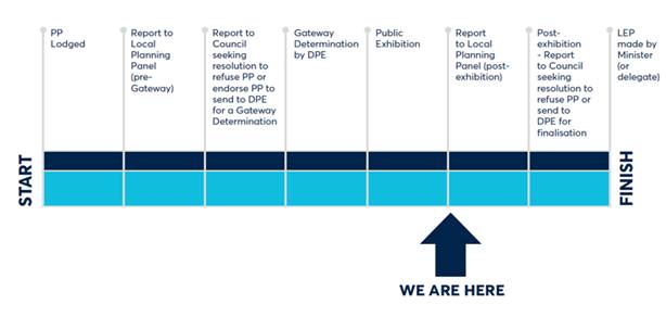
PLANNING PROPOSAL TIMELINE
THE SITE
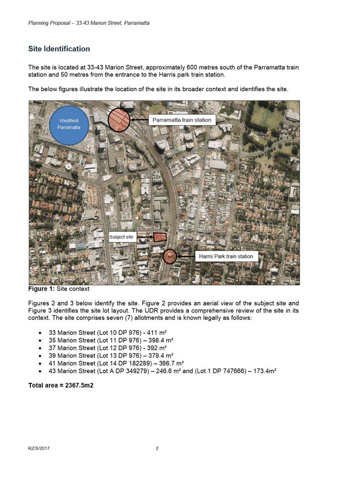
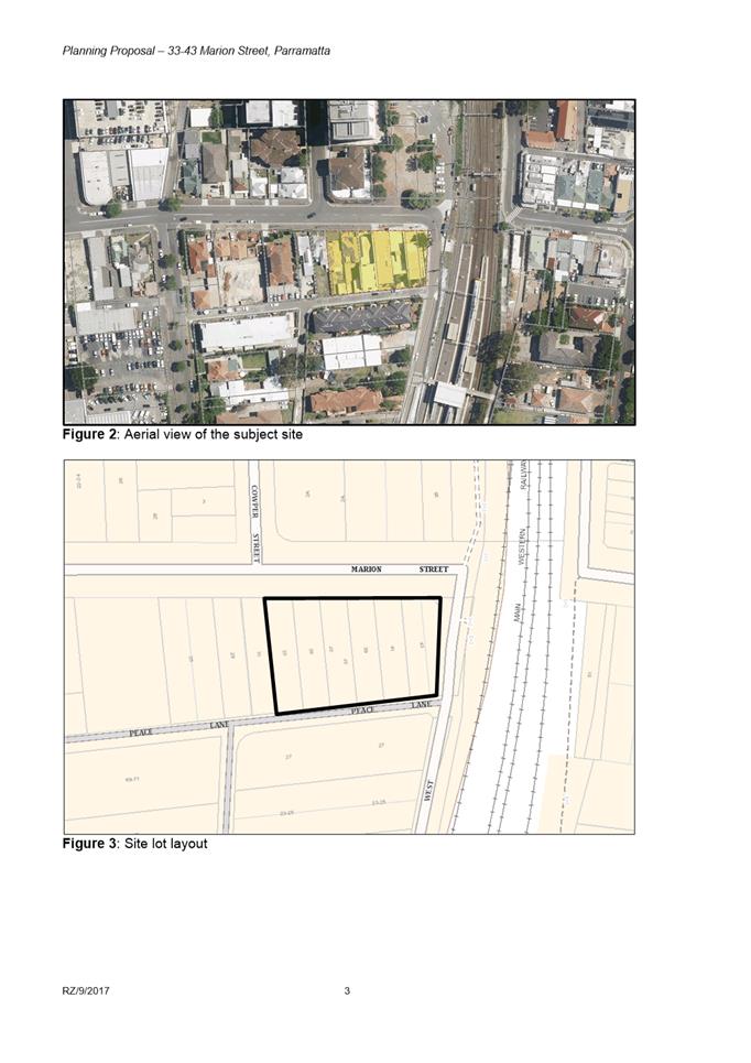
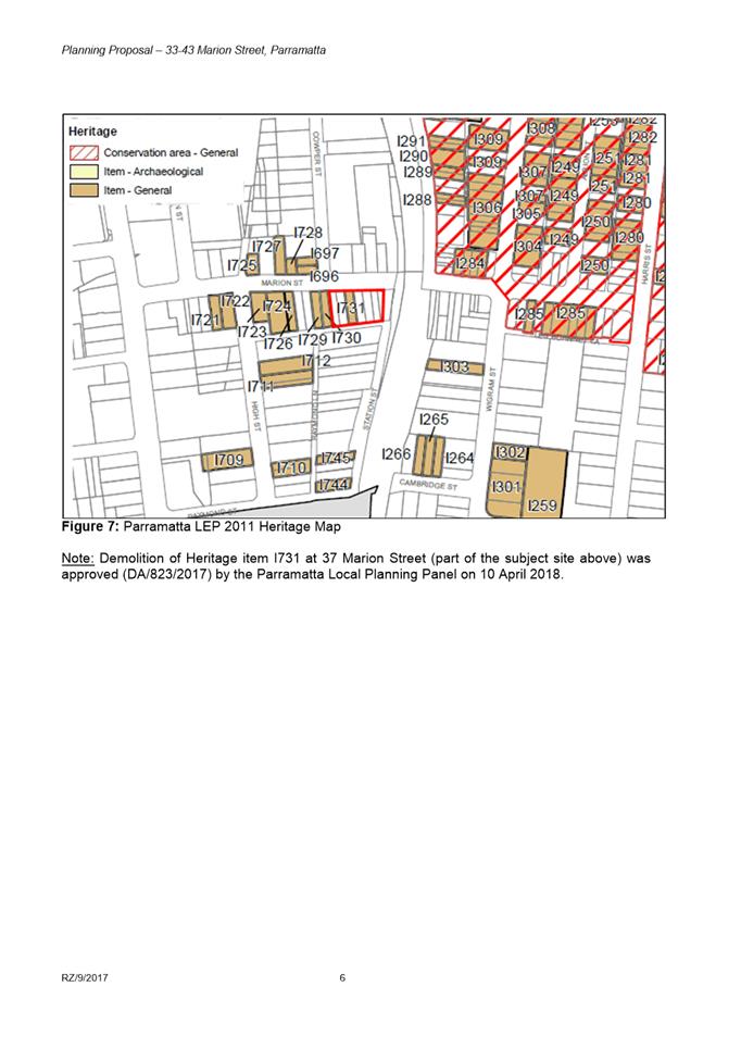
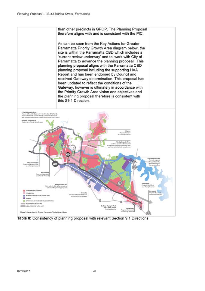
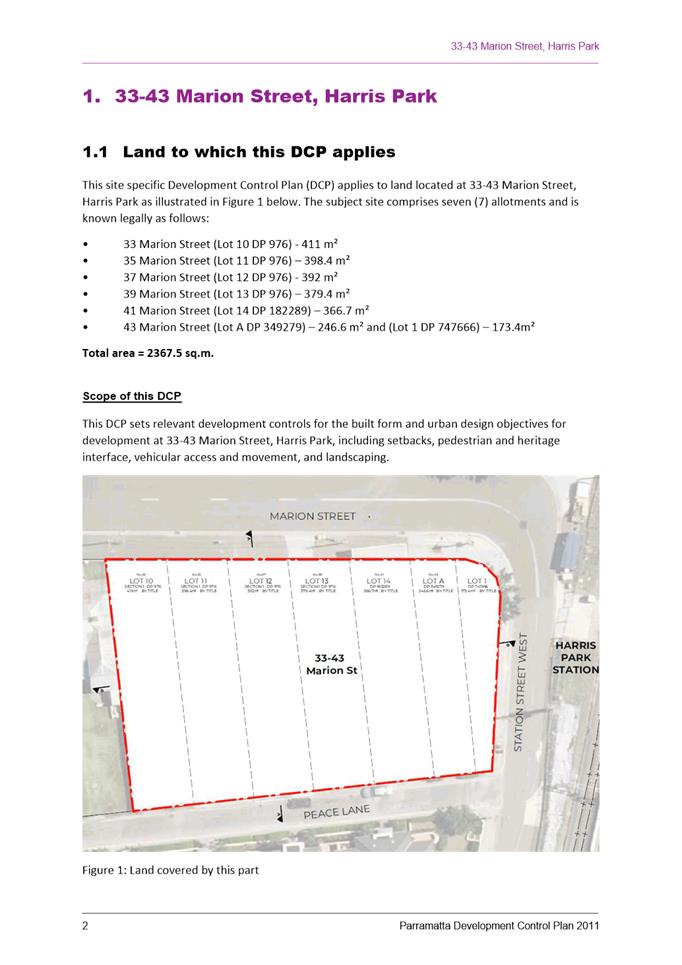
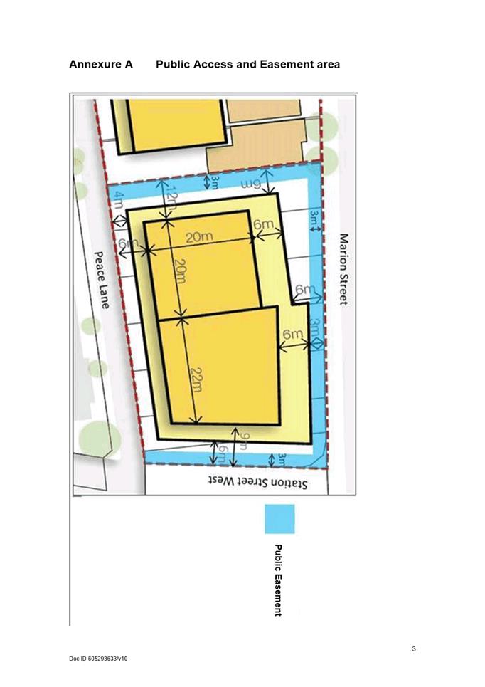
1. The subject site is located at 33-43 Marion Street, Parramatta, as shown in Figure 1. It has an area of approximately 2,367 square metres and is bound by Marion Street to the north, Station Street West to the east, Peace Lane to the south and a single-storey heritage-listed dwelling to the west.
2. The subject land itself contains six properties containing the following:
· 33 Marion Street - a single-storey residential dwelling;
· 35 Marion Street - a single-storey residential dwelling;
· 37 Marion Street - a single-storey residential dwelling currently identified as a Heritage Item in the Parramatta LEP 2011 (but for which development consent has been granted for demolition);
· 39 Marion Street - a two-storey commercial building;
· 41 Marion Street - a two-storey mixed-use building; and
· 43 Marion Street - a three-storey commercial building.
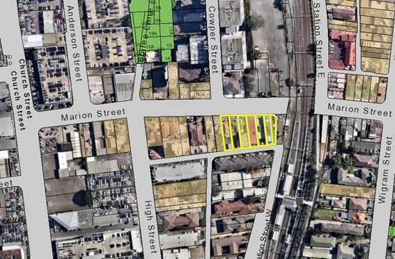
Figure 1: The subject sites outlined in yellow
BACKGROUND
3. In May 2019, a Planning Proposal was lodged for 33-43 Marion Street, Parramatta, which sought to increase the maximum floor space ratio control from 2:1 to 10:1 and increase the maximum height of buildings control from 12 metres to 120 metres. The applicant proposes to develop a mixed-use building on the site.
4. At its meeting on 12 February 2018, Council resolved to endorse the Planning Proposal with a maximum floor space ratio of 6:1 and with no maximum height of building controls. The endorsed Planning Proposal also included the delisting of local heritage items I729 (29 Marion Street), I730 (31 Marion Street) and I731 (37 Marion Street). It is noted that 29 and 31 Marion Street did not form part of the proposed development site.
5. On 23 April 2018, the Parramatta Local Planning Panel granted development consent for the demolition of existing buildings at 37 to 43 Marion Street including the locally heritage listed dwelling at 37 Marion Street, Parramatta. As of July 2020, demolition has still not commenced.
6. On 23 July 2018, the (then) Department of Planning and Environment (Department) issued a Gateway Determination which required the Planning Proposal and Urban Design Report to be updated to reflect various conditions. In summary, the Gateway Determination required that the applicant provide the Department with a further assessment of the proposed built form controls and the impacts on local character and that the delisting of heritage items at 29 and 31 Marion Street be removed from the Planning Proposal.
7. Additional material was provided to the Department in November 2018 and subsequently the Department issued an Alteration of the Gateway Determination on 27 May 2019. The amended Gateway conditions required that the Planning Proposal be consistent with the Gateway Determination for the Parramatta CBD Planning Proposal and any subsequent study prepared by Council in relation to heritage and the built form controls for Marion Street.
8. It was noted that Council had resolved prior to the Alteration to the Gateway Determination, at its meeting on 25 March 2019, to prepare a precinct plan with supporting heritage analysis for the Marion Street precinct. The applicant requested that their site-specific Planning Proposal not be progressed until the outcome of the precinct plan was known and endorsed by Council. The Marion Street Precinct Plan is described in detailed below.
COMPARISON OF PLANNING CONTROLS: EXISTING, PARRAMATTA CBD PLANNING PROPOSAL AND SITE-SPECIFIC PLANNING PROPOSAL
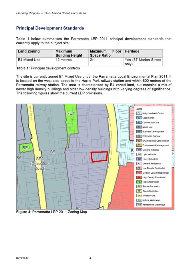
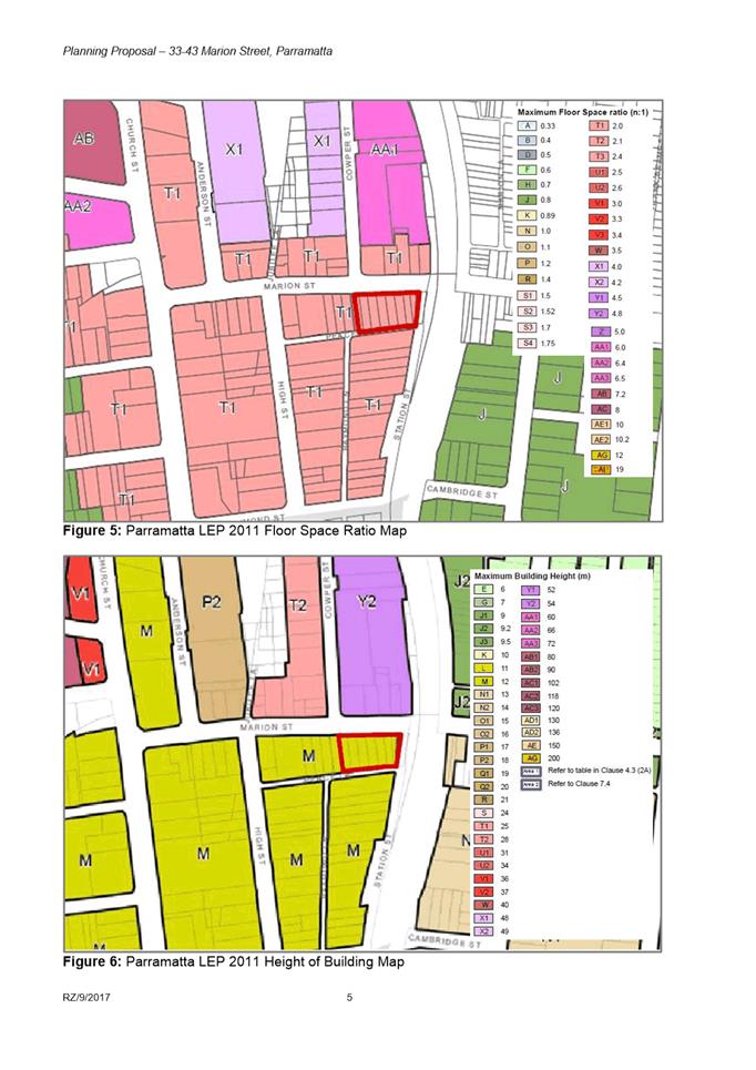
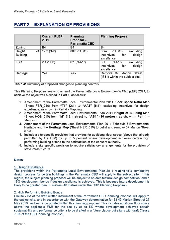
9. Table 1 outlines the planning controls for the site under (1) existing Parramatta LEP 2011, (2) Parramatta CBD Planning Proposal and (3) proposed under the site-specific Planning Proposal.
Table 1: Summary of proposed controls
|
|
Parramatta LEP 2011 |
Parramatta CBD Planning Proposal |
Subject Planning Proposal |
|
Site Area |
2,367.5m2 |
||
|
Land Use Zoning |
B4 Mixed Use |
B4 Mixed Use |
B4 Mixed Use |
|
Height of Buildings |
12m |
80m |
80m |
|
Floor-space ratio |
2:1 |
6:1 |
6:1 |
|
Parking |
In accordance with Clause 7.3 |
Strategic Transport Study rates |
Strategic Transport Study rates 1 |
|
Heritage |
37 Marion St listed |
37 Marion St listed |
37 Marion St delisted |
|
Number of dwellings 2 |
55 dwellings |
167 dwellings |
167 dwellings
|
1 Following inclusion of amendments recommended in this report
2 The number of dwellings has been estimated based on the maximum achievable residential gross-floor area (excluding bonuses) divided by an average apartment size of 85m2
10. In summary, following application of maximum car parking rates in accordance with the Parramatta Strategic Transport Study rates, this Planning Proposal will be consistent with the Parramatta CBD Planning Proposal.
MARION STREET PRECINCT PLAN
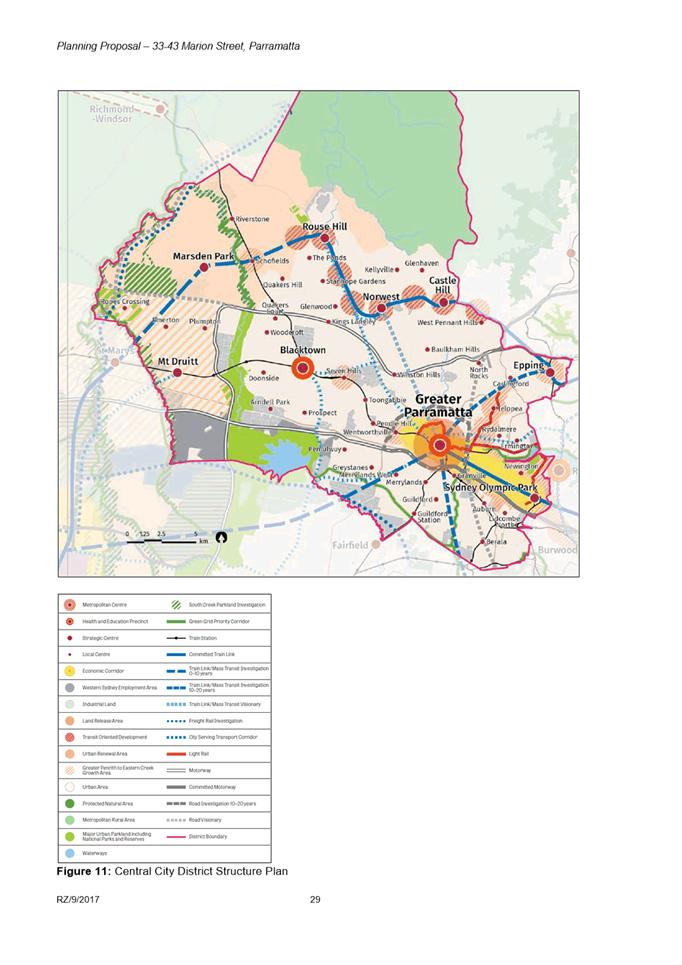
11. The Marion Street Precinct Plan (the Plan) was commissioned by Council and prepared by an independent urban design and heritage consultant (SJB Urban with specialist input from Paul Davies Heritage Consultants) in September 2019. Its purpose was to investigate the heritage values of the Marion Street precinct and the potential heritage impacts resulting from the Parramatta CBD Planning Proposal.
12. The Plan provided recommendations which mitigate adverse impacts on heritage values through modifications to the proposed planning controls in the Parramatta CBD Planning Proposal and proposed further controls that could be incorporated into a future Development Control Plan.
13. In relation to the subject site, the Plan supported a floor space ratio control of 6:1 plus design excellence provisions. The Plan also acknowledged the subject Planning Proposal at 33-43 Marion Street and thus provided detailed built-form controls that could be incorporated into a site-specific Development Control Plan.
14. At its meeting on 25 November 2019, Council endorsed the updated draft Parramatta CBD Planning Proposal which included the recommendations of the Marion Street Precinct Plan.
15. At its meeting on 10 February 2020, Council endorsed the draft DCP and draft Planning Agreement for the subject site for the purpose of publicly exhibiting the material concurrently with the Planning Proposal. The Draft DCP is also consistent with the recommendations of the Plan.
PUBLIC EXHIBITION
16. The Planning Proposal, draft site-specific DCP and draft Planning Agreement for 33-43 Marion Street were publicly exhibited from 22 May 2020 to 22 June 2020. The public exhibition included:
· Letters to neighbouring landowners to notify them of the pubic exhibition
· Letters to Transport for NSW, Roads and Maritime Services and Heritage NSW, notifying them of the public exhibition
· All relevant exhibition material placed on the Council’s website and the NSW Planning Portal
17. The COVID-19 Legislation Amendment (Emergency Measures) Act 2020 enacted on 14 May 2020 removed the requirement for hard copies of exhibition material to be made available during public exhibitions and removed the need to advertise public exhibitions of DCPs and Planning Agreements in a local newspaper. Further, Council Libraries and the Customer Contact Centre were closed to the public during the exhibition period, therefore it was not possible to view hard-copy exhibition materials during this exhibition.
18. All neighbouring residents were provided with the contact details of the relevant Council Officer overseeing the public exhibition and were advised to contact the Officer should they require alternative access arrangements to the exhibition material. It is noted that Council Officers did not receive any telephone calls from the public requesting access to hard copy material.
19. The exhibition material consisted of a copy of the Planning Proposal, draft site-specific Development Control Plan, draft Planning Agreement and supporting appendices including:
· The July 2018 Gateway Determination and May 2019 and March 2020 amended Gateway Determinations;
· Urban Design Report;
· Statement of Heritage Impact;
· Heritage Fabric Analysis and Photographic Report;
· Heritage Response to Gateway Determination conditions;
· Traffic and Transport Assessment;
· Council-endorsed Marion Street Precinct Plan;
· Planning Agreement Explanatory Note; and
· Previous Council Officer assessment reports to Council.
20. Six (6) submissions were received during the public exhibition. This includes two submissions received from the public agencies (Transport for NSW and Heritage NSW) and four submissions from community members. A summary of all submissions and Council Officer responses is provided at Attachment 1.
SUBMISSION SUMMARY AND RESPONSE
Public Agency Submissions
21. Heritage NSW and a consolidated submission from Transport for NSW and Roads & Maritime Services were submitted to Council. Issues identified by public agencies which relate to strategic planning issues are summarised in Table 2 below.
Table 2: Summary of planning issues raised by Public Agencies
|
Submission |
Council Officer response |
|
Transport for NSW (TfNSW) and Roads & Maritime Services (RMS) |
|
|
The maximum parking rates recommended by the Parramatta CBD Strategic Transport Study and set out in the draft Parramatta CBD Planning Proposal are to be incorporated into the Planning Proposal. |
The Planning Proposal did not incorporate any site-specific car parking rates and will be amended post-exhibition to incorporate maximum car parking rates in accordance with the CBD Strategic Transport Study. As this amendment does not result in a greater environmental impact because there will be an overall reduction of parking included as part of any development, Council Officers are not of the opinion that the Planning Proposal needs to be re-exhibited as a result of this change. |
|
An appropriate funding mechanism/ agreement should be in place prior to the finalisation of any amendment to the LEP for the precinct. |
The Planning Proposal responds to Condition 1(m) of the Gateway Determination which requires a satisfactory arrangements clause for the provision of regional and state infrastructure. Council Officers will further discuss the inclusion of a satisfactory arrangements clause with the Department of Planning, Industry and Environment (DPIE) prior to finalisation. Council Officers are not satisfied that requiring an additional contribution from this site is a defendable position due to the inconsistency in the way this and other sites with similar applications are being treated. Several Gateway Determinations for site specific Planning Proposals within the Parramatta CBD have been issued without the requirement for a contribution for State infrastructure. Further the applicant has already agreed to enter into a Planning Agreement which provides a contribution towards public domain improvements in the Parramatta CBD if the site is developed for residential purposes. However, it is for DPIE to determine whether it would like to retain the satisfactory arrangements clause, in required by the Gateway Determination, when the Planning Proposal is being finalised. |
|
Abutting the site to the east is Station Street West which is currently owned by RailCorp. It is considered that Council should use the current process to initiate discussions with Sydney Trains (as agent for RailCorp) and begin working towards having this land (if confirmed to be no longer required by Sydney Trains/TfNSW) to be dedicated as public road and transferred to Council. |
Council Officers have contacted Sydney Train’s Property Services division to seek additional clarity regarding the submission and were advised that Sydney Trains is developing an internal process to resolve similar scenarios where RailCorp land is being used for non-rail related public purposes (the site is currently part of the public roadway). Based on this correspondence, Council Officers are satisfied that the matter can be resolved outside of the Planning Proposal and note that the development of this site is not reliant on this parcel of land for vehicular access. |
|
Heritage NSW |
|
|
The proposed controls in the DCP would go some way to mitigate the impacts of new development on the nearby heritage items and Heritage Conservation Areas. However, should the Planning Proposal be supported, design refinements should be considered during any future development application to minimise any remaining impacts from the development. |
Noted. The proposed development will be subject to a Design Excellence competition in which further consideration will be given to minimising the development’s impact on nearby heritage items.
|
Community Submissions
22. A total of four (4) submissions were made by members of the community. Common key issues have arisen during the exhibition period and are summarised in Table 3 below.
Table 3: Summary and response to community submissions
|
Key Issue |
Council Officer response |
|
Neighbourhood character & change · The proposal is out of character with the existing quiet neighbourhood · The proposed height is contextually inappropriate · The Planning Proposal will set an undesirable precedent |
Council’s vision for Parramatta CBD is consistent with that of the strategies adopted by the NSW Government, which envisage Parramatta as Sydney’s Central City. Council has endorsed the Parramatta CBD Planning Proposal which seeks to provide additional residential and commercial capacity in the Parramatta CBD to ensure that the city evolves into a high-amenity metropolitan hub. The Planning Proposal has been assessed against the controls sought in the Parramatta CBD Planning Proposal and it is consistent. Further, it is noted that surrounding sites, with the exception of the heritage item cluster along Marion Street, will also have their planning controls amended to allow for similar scale of development. It is accepted that this site-specific Planning Proposal will contribute to a changing neighbourhood character in line with the future character set in State and Council strategies. As such, the site-specific Planning Proposal is consistent with the desired future character of the Parramatta CBD. The Parramatta CBD Planning Proposal has been prepared following numerous technical studies. These studies relate to urban design, heritage, flooding, economic analysis, traffic and transport modelling, infrastructure funding and environmental sustainability. This process has ensured that the cumulative effects of the Parramatta CBD Planning Proposal are considered and appropriately managed. |
|
Heritage · The demolition of heritage items is not supported · The Planning Proposal will have adverse impacts on nearby heritage items |
The Parramatta Independent Hearing and Assessment Panel has granted consent for the demolition of the Heritage Item at 37 Marion Street on 17 April 2017 (DA/823/2017). This Planning Proposal seeks to remove the heritage listing from the Parramatta LEP 2011 map in response to this approved demolition. Council commissioned the Marion Street Precinct Plan as a response to a Gateway Determination condition pertaining to the Parramatta CBD Planning Proposal. The Precinct Plan investigated the building typologies along Marion Street and provided recommendations for the future planning of this precinct. The Precinct Plan did not conclude that the precinct should be designated as a heritage conservation area. However, the Precinct Plan did test building massing along the street and recommended that the scale of development be reduced on sites surrounding the cluster of heritage items along the street. This site is not located in this cluster and the study supported the subject site being developed with the exhibited floor-space ratio and height controls. |
|
Amenity · Local amenities cannot support such an increase in density · The proposal will result in more traffic |
The Planning Agreement for site, which was placed on public exhibition, proposes a monetary contribution to be made to Council which is to be used towards public domain upgrades and delivery of further infrastructure in the Parramatta CBD. It also provides easements for public access so that the development can provide widened footpaths and a through-site link. As part of the Parramatta CBD Planning Proposal, planning for open space and supportive community infrastructure is being prepared to support planned development. The draft Infrastructure Needs Analysis Study assessed infrastructure needs as a result of increased development, including community infrastructure. The findings of the study formed part of a Discussion Paper - Infrastructure Planning and Funding in the Parramatta CBD, which was publically exhibited in March 2017. The Discussion Paper has informed the Parramatta CBD Infrastructure Strategy which is used when negotiating Planning Agreements related to site-specific Planning Proposals. The Planning Proposal will be amended to apply maximum car parking rates in accordance with the rates specified in the Parramatta CBD Strategic Transport Study. The Study investigated the traffic impacts of the Parramatta CBD Planning Proposal and clearly indicated that private vehicle use needs to be appropriately discouraged in conjunction with improvements to public and active transport as alternative modes in order to avoid complete saturation of the road network. As such, Council has adopted reduced car parking rates for the Parramatta CBD in order to mitigate traffic impacts of a denser CBD core, encourage a mode shift to public and active transport and to support the viability of continued investment in transport infrastructure. |
|
Environmental risk · Intense development on the site is not suitable as surrounding areas have been affected by landslides · Any excavation will undermine the structural stability of surrounding buildings |
Any excavation work or piling will require a Geotechnical Investigation to be completed by the applicant prior to lodging a Development Application. This will ensure that the excavation and piling is carried out in a safe manner that does not undermine the structural stability of the site and surrounding properties. Given the sites proximity to a railway corridor, the Geotechnical Investigations will need to be reviewed by both Council and Transport for NSW before excavation works can commence on the site. |
DRAFT DEVELOPMENT CONTROL PLAN
23. The draft site-specific Development Control Plan (DCP) was prepared in accordance with the built form controls recommended in the Marion Street Precinct Plan. It includes provisions relating to through-site links, public domain improvements, tree planting and vehicular access to the site.
24. The draft site-specific DCP has been amended post-exhibition in response to a public submission which raised concerns that the proposed draft controls relating to the through-site link were not sufficiently detailed and could not ensure an optimal design outcome. Therefore an additional objective and control has been inserted into the draft DCP which seeks to ensure that the through-site link provides a high level of pedestrian amenity, safety and security, therefore requiring that any through-site link is legible, open to the sky and well-lit at night.
DRAFT PLANNING AGREEMENT
25. A draft Planning Agreement has been drafted in accordance with Council’s Planning Agreements Policy and provides for a monetary contribution of $1,420,500 if the site is developed as a mixed-use building. Further, acknowledging that Council is undertaking a review of the community infrastructure rates, the Planning Agreement has been drafted in a manner so that the monetary contribution amount can be amended, should Council adopt different community infrastructure rates as part of the Parramatta CBD Community Infrastructure framework so the contribution paid is consistent with Council’s Policy at the time the payment is made.
26. The value of the monetary contribution contained within the draft Planning Agreement is based on the calculations in Table 4 below:
Table 4: Calculation of monetary contribution
|
Development parameters |
|
|
Site Area |
3,283 m2 |
|
Base FSR |
2:1 |
|
Incentive FSR (Phase 1) |
6:1 |
|
Phase 1 calculation |
|
|
Incentive FSR minus base FSR |
6:1 - 2:1 = 4:1 |
|
Increase in FSR multiplied by site area |
4 x 2,367 = 9,468 m2 |
|
Increase in floor area multiplied by $150* |
9,468 x $150 = $1,420,200 |
|
Total |
$1,420,200 |
*Planning Agreement has been drafted in a manner so that the monetary contribution amount can be amended, should Council adopt different community infrastructure rates as part of the Parramatta CBD Community Infrastructure framework.
27. The applicant requested on 18 June 2020 (following public exhibition) an amendment to the draft Planning Agreement. The changes they have made to the Planning Agreement document exhibited seems to suggest changes to definitions and the formula for calculating the contribution which seek to:
|
Amendments Proposed by Applicant |
Officer Comment |
|
Clarify that contributions will not be paid on any bonus FSR achieved under Council’s LEP (such as design excellence or high performing building) or offered by State Environmental Planning Policies (such as those available under the Affordable Rental Housing 2009 and Housing for Seniors and People with a Disability 2004). |
This is consistent with Council’s policy framework and recent practice.
Council Officers are of the opinion that community infrastructure should not be levied against any additional floor-space achieved under the Affordable Rental Housing 2009 or the Housing for Seniors and People with a Disability 2004 State Environmental Planning Policies. Council’s Affordable Housing Policy has identified the need for additional affordable rental housing in the City of Parramatta LGA, therefore by removing any additional costs associated with its provision may encourage its provision.
It is noted that the applicant has not proposed any affordable rental housing or seniors housing as part of their Planning Proposal, but nothing prevents them from doing so at development application stage. |
|
Confirm that contributions are only payable on residential development achieved above the base FSR of 2:1 that is approved as part of a future development application. |
In recent Planning Agreements for sites in the CBD the formula for calculating the Community infrastructure contribution has been amended so that it is based on the FSR achieved in the development application not just the increase in FSR permitted by the Planning Proposal therefore this amendment is supported. |
|
Ensure the community infrastructure contribution does not apply to commercial floor space.
|
Council Officers are concerned that the applicant may have misinterpreted the application of Council’s policy exemption of commercial floor space from community infrastructure when drafting their proposed amendments. The policy is based on the following criteria:
(a) That if the development proposes a primarily residential development and any ancillary commercial development on this site is less than the current 2:1 base FSR then the commercial floor space provided should have no impact on the calculation of the community infrastructure payable. (b) If the development proposed is a mixed use development and the development provides commercial floor space greater than the 2:1 base FSR or entirely commercial development then no community infrastructure should be charged for any commercial floor space exceeding the 2:1 base FSR on this site. Noting community infrastructure is not applied to any base FSR regardless of the use of this floor space. |
28. It is recommended that Council authorise the Chief Executive Officer to finalise the draft Planning Agreement in accordance with the principles specified in the table above.
29. It is further noted that at the time of writing this report, Council Officers have sought legal advice pertaining to the proposed amendments to the Planning Agreement. Issues relating to the proposed amendment may be resolved before this matter is reported.
FINANCIAL IMPLICATION FOR COUNCIL
30. The Planning Agreement requires a monetary contribution in the amount of $1,420,500 if the size is developed for mixed-use purposes and is to be applied towards upgrades and delivery of new public domain and open spaces in the Parramatta CBD. However, the Planning Agreement has been drafted in a manner so that the monetary contribution amount can be amended should Council adopt different community infrastructure rates as part of the Parramatta CBD Community Infrastructure framework.
CONCLUSION
31. The Planning Proposal has satisfied the public consultation requirements of the Gateway Determination and is consistent with the Parramatta CBD Planning Proposal. Council Officers consider that submissions raised during the public exhibition have been addressed adequately.
32. It is recommended that the Local Planning Panel advise Council that following the Planning Proposal being amended to incorporate maximum car parking rates in accordance with the Parramatta CBD Strategic Transport Study the Planning Proposal be forwarded to the Department of Planning, Industry and Environment for finalisation.
33. It is also recommended that the Local Planning Panel advise Council adopt the associated site-specific Development Control Plan and Planning Agreement and advise the Department the final notification only be undertaken once Council confirms that the Planning Agreement has been executed.
34. The advice of the Local Planning Panel on this report will be reported to an upcoming Council meeting.
Marko Rubcic
Project Officer, Land Use Planning
Bianca Lewis
Team Leader Land Use Planning
Robert Cologna
Land Use Planning Manager
David Birds
Group Manager City Planning
Jennifer Concato
Executive Director City Planning and Design
|
1⇩ |
Submissions Table |
9 Pages |
|
|
2⇩ |
Planning Proposal |
58 Pages |
|
|
3⇩ |
Draft Development Control Plan |
5 Pages |
|
|
4⇩ |
Draft Planning Agreement |
30 Pages |
|
|
5⇩ |
List of Landowners |
1 Page |
|
REFERENCE MATERIAL
|
Item 6.1 - Attachment 1 |
Submissions Table |
Table 1: Government Agency Submissions
|
Agency Submission Summary |
Council Officer response |
|
Transport for NSW – is a consolidated response from the Transport for NSW cluster, including RailCorp, Sydney Trains & Roads and Maritime |
|
|
The maximum parking rates recommended by the Parramatta CBD Strategic Transport Study and set out in the draft Parramatta CBD Planning Proposal are to be adopted for the subject site within a site-specific clause in the LEP. |
The Planning Proposal is to be amended post-exhibition to incorporate maximum car parking rates in accordance with the CBD Strategic Transport Study. As this amendment does not result in a greater environmental impact as it results in a potential to reduce the overall parking included as part of any development, Council Officers are not of the opinion that the Planning Proposal needs to be re-exhibited as a result of this change. |
|
TfNSW is supportive of the larger open spaces, setbacks and through-site links proposed as part of the ground floor development controls. Ideally, the wider pedestrian paths should continue south towards the station as further developments occur. |
Noted. |
|
An appropriate funding mechanism/ agreement should be in place prior to the finalisation of any amendment to the LEP for the precinct. This will help ensure that developer contributions are obtained on a transparent and equitable basis for the provision of state and regional transport infrastructure required to support development uplift and future growth in the Parramatta precinct. |
The Planning Proposal responds to the conditions of the Gateway Determination requiring a satisfactory arrangements clause for the provision of regional and state infrastructure (see Condition 1(m) of the Gateway Determination issued 23 July 2018). Council Officers will further discuss the inclusion of a satisfactory arrangements clause with the Department of Planning, Industry and Environment (DPIE) once the Planning Proposal prior to finalisation. |
|
As part of the future development application, assessment using an appropriate tool (e.g. SIDRA modelling) of nearby intersections, including the electronic SIDRA files and network output tables, should be provided to assess the impacts of additional vehicle trips on the surrounding road network. Specifically, the impacts at the intersection of Marion Street and Church Street will need to be investigated. |
Noted. The applicant has been supplied with this submission for their future consideration and has concurred that traffic modelling will occur, having particular regard to the Marion Street and Church Street intersection as part of a Traffic Assessment lodged with a development application.
|
|
Given the scale of development involved, it is paramount that the developer approach Sydney Trains early in the design process (as part of pre-DA discussion) to ensure that all relevant Sydney Trains matters of consideration are taken into account and are incorporated in the future design of the development. These considerations include, but are not limited to, geotechnical and structural details and construction methodology, (no rock anchors/bolts within RailCorp land). |
Noted. The applicant has been provided with a copy of this submission for consideration. |
|
Abutting the site to the east is Station Street West which is currently owned by RailCorp. It is considered that Council should use the current process to initiate discussions with Sydney Trains (as agent for RailCorp) and begin working towards having this land (if confirmed to be no longer required by Sydney Trains/TfNSW) to be dedicated as public road and transferred to Council. It is imperative that in the meantime, any design of future development on the site at 33-43 Marion Street does not rely on this land for any vehicular or pedestrian access. |
The proposal’s vehicular and pedestrian access does not rely on the adjoining site, therefore Council Officers believe that the progression of this Planning Proposal is separate to the resolution of the property matter raised by TfNSW. Council Officers have contacted Sydney Train’s Property Services division to seek additional clarity regarding the submission and were advised that Sydney Trains is developing an internal process to resolve similar scenarios where RailCorp land is being used for public purposes (the site is currently part of the public roadway). Based on this correspondence, Council Officers are satisfied that the matter can be resolved outside of the Planning Proposal and the contact details for Council’s Property and Assets Manager has been provided to Sydney Trains so the two parties can commence engagement once Sydney Trains is ready to do so. |
|
As RailCorp is an adjoining landowner, it is requested that Council and developer liaise with Sydney Trains throughout each stage of the planning and development process of this site. |
Noted. The applicant has been provided with a copy of this submission for consideration at development application stage. |
|
The Department of Planning’s – Development Near Rail Corridors and Busy Roads Interim Guidelines, which will need to be considered and addressed in the any future development application for this site.
|
Noted. The applicant has been provided with this submission for their consideration at development application stage. |
|
Heritage NSW (formerly Office of Environment and Heritage) |
|
|
The proposed controls in the DCP would go some way to mitigate the impacts of new development on the nearby heritage items and Heritage Conservation Areas. However, should the planning proposal be supported, design refinements should be considered during any future development application to minimise any remaining impacts from the development. |
Noted. The proposed development will be subject to a Design Excellence competition in which further consideration will be given to minimising the development’s impact on the HCA and heritage items.
|
|
The Heritage Council of NSW has concerns regarding the number of planning proposals seeking increases in the density of individual sites within the Parramatta CBD. It is recommended that the Parramatta CBD Planning Proposal be resolved prior to further consideration of individual site-specific planning proposals seeking increases in density. |
Despite the CBD Planning Proposal still not being finalised, the Department of Planning and Environment has issued Gateway Determinations for site-specific Planning Proposals within the Parramatta CBD that allow them to be publicly exhibited. The Gateway Determination issued for this site-specific Planning Proposal did not condition the resolution of issues relevant to the CBD Planning Proposal and applied a timeframe for the completion of the LEP instrument.
|
Table 2: Public submissions
|
Submission Summary |
Council Officer response |
|
Submission 1
|
|
|
A height of 80m is contextually inappropriate given 54m is the highest permitted elsewhere in the locality |
This site-specific Planning Proposal acknowledges the evolving context of the Parramatta CBD which has been identified as Sydney’s Central City. Council has endorsed the Parramatta CBD Planning Proposal which seeks to provide additional residential and commercial capacity in the Parramatta CBD to ensure that the city evolves into a high-amenity metropolitan hub. The Planning Proposal has been assessed against the controls proposed in the CBD Planning Proposal and it is consistent. Further, it is noted that surrounding sites, with the exception of the heritage item cluster along Marion Street, will also have their planning controls amended to allow for similar scale of development. |
|
The scale is inappropriate given the vicinity to heritage items – there are sufficient grounds for the area to be a heritage conservation area |
The Cracknell and Lonergan Heritage Studies submitted with the Planning Proposal assessed the Marion Street precinct and made an assessment against nearby Heritage Conservation Areas. The study concluded that “Marion Street does not reach any reasonable threshold for consideration as a conservation area by admission in the content of both the Urbis and HAA report [commissioned by Council] or the LEP or previous heritage studies”. This heritage study was provided to the Department of Planning, Industry and Environment as part of the Gateway Determination. Subsequently a condition of the Gateway Determination that the proposal be consistent with any heritage study to be completed by Council for the Marion Street Precinct. Subsequently, Council commissioned the Marion Street Precinct Plan in order to investigate the building typologies along Marion Street and to issue recommendations for the future planning of this precinct. The Precinct Plan did not conclude that the precinct should be designated as a heritage conservation area. However, the Precinct Plan did test building massing along the street and recommended that the scale of development be reduced on sites surrounding the cluster of heritage items along the street. This site is not located in this cluster and the proposed scale is consistent with the findings of the study. |
|
NSW Heritage’s ‘Design in Context’ states that Infill design should recognise the predominant scale (height, bulk, density, grain) of the setting and then respond sympathetically – this development does not do this. |
This site-specific Planning Proposal acknowledges the evolving context of the Parramatta CBD which has been identified as Sydney’s Central City. Council has endorsed the Parramatta CBD Planning Proposal which seeks to provide additional residential and commercial capacity in the Parramatta CBD to ensure that the city evolves into a high-amenity metropolitan hub. The Planning Proposal has been assessed against the controls proposed in the CBD Planning Proposal and it is consistent. Further the setback controls in the site-specific DCP have been informed by the Precinct Plan and incorporates a front setback which increases as it approaches the heritage item cluster on Marion Street. Further, it is noted that Heritage NSW is the part author of the Design in Context guideline and the Agency did not object to the Planning Proposal. |
|
The proposed 9 metre setback (in the Urban Design Report) to the boundary of a single storey heritage item is inadequate |
The setback controls in the site-specific DCP supersede the setback controls shown in the Urban Design Report and are contained in the draft DCP that was on public exhibition. The setback
controls are consistent with the Marion Street Precinct Plan completed by SJB
and endorsed by Council to support the Parramatta CBD Planning Proposal. The
building podium will be setback a minimum 6 metres from the western property
boundary and that the tower be set back a futher 6 metres from the podium (a
total 12 metre setback from the boundary line). |
|
The setback in the site-specific DCP and Urban Design Report are inconsistent |
It is acknowledged that the podium and tower setbacks differ in the site-specific DCP and the Urban Design Report. This discrepancy was highlighted on Page 27 of the Urban Design Report where it articulates that the reference design is for indicative purposes only and demonstrates the detailed urban design and development application testing that has been completed to support the Planning Proposal. The associated site-specific DCP supersedes any inconsistencies that may be contained within the reference design. |
|
The 3m width of the through-site link is inadequate and will not create a safe environment, will make the heritage item susceptible to graffiti and provide poor amenity for its residents. The through-site link should be widened to allow for planting along the boundary of the heritage item |
As outlined in the draft site specific DCP, a minimum 6 metre setback is to be provided along the western boundary of the site. Of this setback, at least 3 metres will need to be provided as an easement for public access, as specified in the draft Planning Agreement. Thus at least 3 metres of the 6 metre setback will be trafficable for pedestrians while the landowner will have the flexibility of providing the additional 3 metre setback as additional width to the pedestrian thoroughfare, landscaping, or can elect to use this space for private purposes (for example, outdoor dining). The use of this space will be determined at development application stage. |
|
The draft DCP is overly simplistic. There is no indication as to how the development will ‘provide a suitable interface with adjoining heritage items’. It does not deal with how the through-site link suitably interfaces with the heritage item, whether it is open to the sky and how safety is provided. |
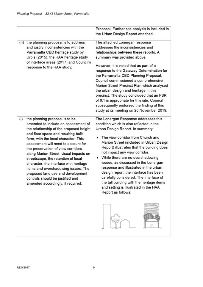
Any future development on this site would be required to undergo a Design Excellence competition and subsequently lodge a development application based on the winning scheme. It is at these stages that the detail of the setback and interface with the heritage item will be known. In relation to the design principles raised in this submission, an additional site-specific provision is proposed to be included to ensure that the through-site link is legible, safe, well lit at night and open to the sky. |
|
Submission 2
|
|
|
The proposed building height is incompatible with the current planning controls |
This site-specific Planning Proposal acknowledges the evolving context of the Parramatta CBD which has been identified as Sydney’s Central City. Council has endorsed the Parramatta CBD Planning Proposal which seeks to provide additional residential and commercial capacity in the Parramatta CBD to ensure that the city evolves into a high-amenity metropolitan hub. The Planning Proposal has been assessed against the controls proposed in the CBD Planning Proposal and it is consistent. Further, it is noted that surrounding sites, with the exception of the heritage item cluster along Marion Street, will also have their planning controls amended to allow for similar scale of development. |
|
The land surrounding the site has been prone to landslides. Deep excavation may undermine the structural integrity of surrounding buildings. |
Council’s databases do not identify the site as being landslide prone. Detailed environmental analysis of the site, including Geotechnical investigations, will be required at Development Application stage to ensure that any excavation, if suitable on the site, is completed safely and in accordance with Australian Standards. Further as a requirement of Sydney Trains, and developing near a railway line, the applicant will be required to coordinate and consult with transport agencies regarding geotechnical and structural details and construction methodology. |
|
Local amenities cannot support such an increase in density |
The Planning Agreement for site, which was placed on public exhibition, proposes a monetary contribution to be made to Council which is to be used public domain upgrades and delivery in the Parramatta CBD, and provides easements for public access so that the development can provide widened footpaths and a through-site link. As part of the Parramatta CBD Planning Proposal, planning for open space and supportive community infrastructure is being prepared to support planned development. The draft Infrastructure Needs Analysis Study assessed infrastructure needs as a result of increased development, including community infrastructure. The findings of the study formed part of a Discussion Paper - Infrastructure Planning and Funding in the Parramatta CBD, which was publically exhibited in March 2017. The Discussion paper has informed the Parramatta CBD Infrastructure Strategy which is used when negotiating Planning Agreements related to site-specific Planning Proposals. |
|
Submission 3
|
|
|
It should be verified that the applicant, landowners, Councillors and Council staff have declared conflicts of interest in response to allegations made in a Sydney Morning Herald article.
|
In accordance with Section 10.4 of the Environmental Planning and Assessment Act 1979, Planning Proposal applicants must disclose all relevant political donations or gifts when applications are made to minimise any perception of undue influence. The applicant has provided a Political Donations and Gifts Declaration in accordance with this provision of the Act. Further, it is noted that all planning reports to Council list the applicant and landowners on the cover. Council’s Code of Conduct requires all Councillors to declare conflicts of interest before any matter is discussed in the chamber. If any declaration is disclosed, it is noted and the subject Councillor leaves the chamber until that matter is resolved. The site-specific Planning Proposal is consistent with the broader Parramatta CBD Planning Strategy. None of the former staff members listed article were involved in the preparation of the Parramatta CBD Planning Strategy and subsequent Parramatta CBD Planning Proposal. In accordance with Council’s Code of Conduct Policy, Council Officers are require to declare any conflicts of interest should they arise during the assessment of any Planning Proposal. Officers which declare an interest are removed from the assessment of the subject project. Note: Council Officers responded to the submitter providing the contact details for the City of Parramatta Internal Ombudsman service if they wish to escalate any concerns to an independent body which can further investigate any matters. |
|
The scale of development is out of character |
Council has endorsed the Parramatta CBD Planning Proposal which seeks to provide a dense CBD core with high amenity and high accessibility. This vision is also consistent with that of the NSW Government and the Greater Sydney Commission which have identified Parramatta as Sydney’s Central City. The Parramatta CBD Planning Proposal has been drafted in accordance with the recommendations of numerous studies and reports. Most recently, Council has completed the Marion Street Precinct Plan which tests building height and bulk along Marion Street to formulate appropriate urban design-led planning controls which protect the amenity and character of existing heritage items in a future development context. The Planning Proposal is thus consistent with the future character envisioned for Parramatta. |
|
Submission 4
|
|
|
Parramatta does not need any more high-rise developments |
This site-specific Planning Proposal acknowledges the evolving context of the Parramatta CBD which has been identified as Sydney’s Central City. Council has endorsed the Parramatta CBD Planning Proposal which seeks to provide additional residential and commercial capacity in the Parramatta CBD to ensure that the city evolves into a high-amenity metropolitan hub. The Planning Proposal has been assessed against the controls proposed in the CBD Planning Proposal and it is consistent. Further, it is noted that surrounding sites, with the exception of the heritage item cluster along Marion Street, will also have their planning controls amended to allow for similar scale of development. |
|
Heritage Items should not be demolished to facilitate this development |
The Parramatta Independent Hearing and Assessment Panel has granted consent for the demolition of the Heritage Item at 37 Marion Street on 17 April 2017. This Planning Proposal seeks to remove the heritage listing from the Parramatta LEP 2011 map in response to this approved demolition. |
|
Surrounding buildings will be physically damaged due to excavation work which will lead to cracks and weakened foundations |
Any excavation will require a Geotechnical Investigation to be completed by the applicant prior to lodging a Development Application. This will ensure that the excavation is carried out in a safe manner that does not undermine the structural stability of the site and surrounding properties. The Geotechnical Investigations will need to be reviewed by both Council and Transport for NSW before excavation works can commence on the site. |
|
The development will lead to more congestion. |
The Planning Proposal will be amended to apply maximum car parking rates in accordance with the rates specified in the Parramatta CBD Strategic Transport Study. The Study investigated the traffic impacts of the CBD Planning Proposal and clearly indicated that private vehicle use needs to be appropriately discouraged in conjunction with improvements to public and active transport as alternative modes in order to avoid complete saturation of the road network. As such, Council has adopted reduced car parking rates for the Parramatta CBD in order to mitigate traffic impacts of a denser CBD core, encourage a mode shift to public and active transport and to support the viability of continued investment in transport infrastructure. |
|
There are insufficient trees in the vicinity which exacerbates heat |
It is noted that there are no significant trees currently on the sites. The draft site-specific DCP includes a control which seeks to ensure that tree planting is maximised across the entire site, meaning that this development is likely to facilitate more tree canopy than what is already provided on the site. |
|
It is already difficult to find parking in the area |
The intended effect of the reduced car parking rates is to discourage car ownership and promote alternative modes of transport such as public transport or car-share options. Council has the capacity to effectively monitor and regulate the provision of on-street car parking and ensure any impacts are managed so that vehicle usage is discouraged and the various needs of local stakeholders are balanced. |
|
The units at the site situated immediately to the south will not receive any sunlight which will lead to amenity and health impact |
It is acknowledged that the low-rise residential units located immediately to the south will experience additional overshadowing as a result of this development. However, as part of the Parramatta CBD Planning Proposal (which has received a Gateway Determination from the Department of Planning, Industry and Environment), the sites situated immediately to the south will receive increased height and FSR controls under the CBD Planning Proposal. Together with new Stata Laws which make it easier to redevelop strata-subdivided lots, it is therefore likely that the site will be redeveloped over time. |