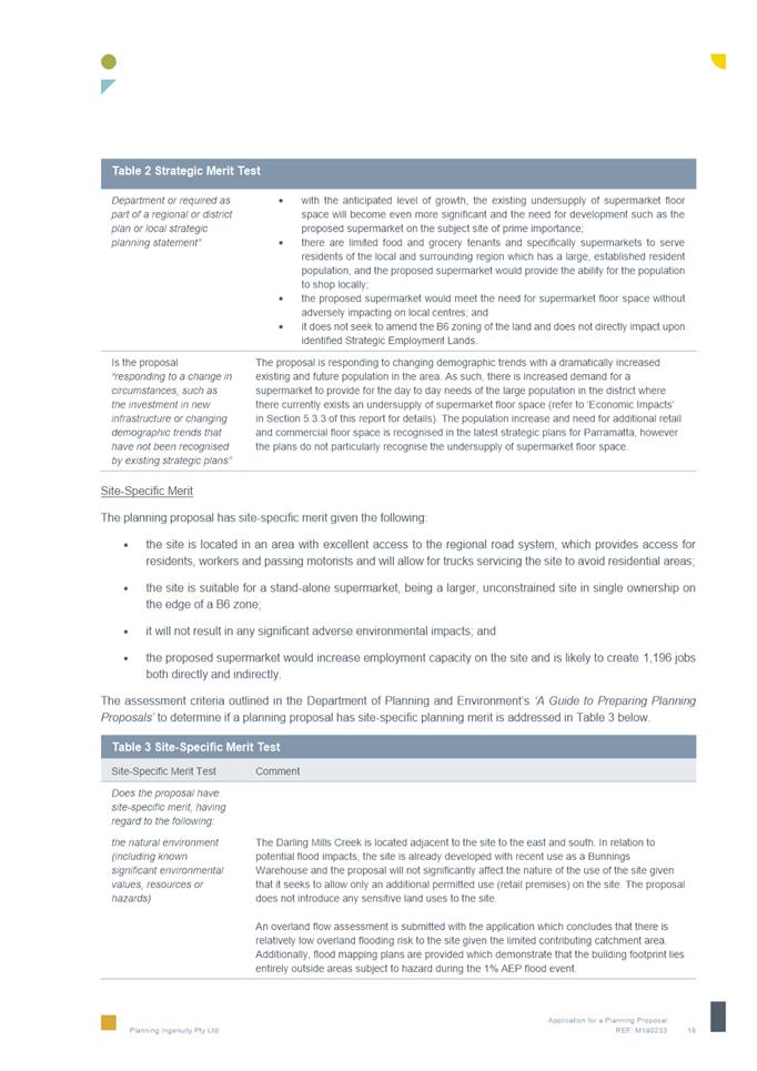
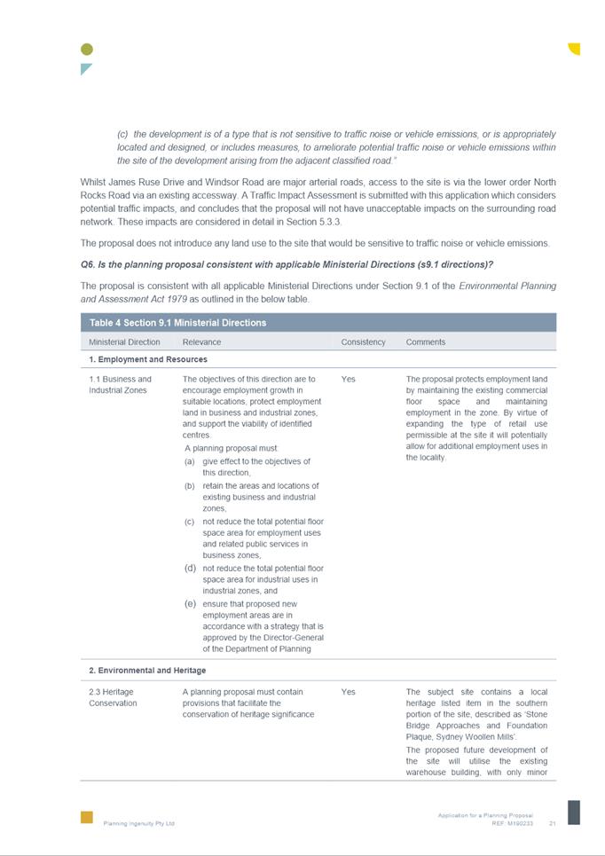
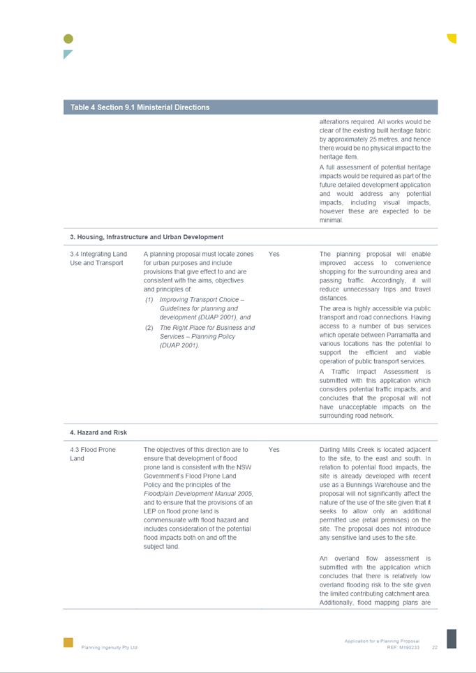
|
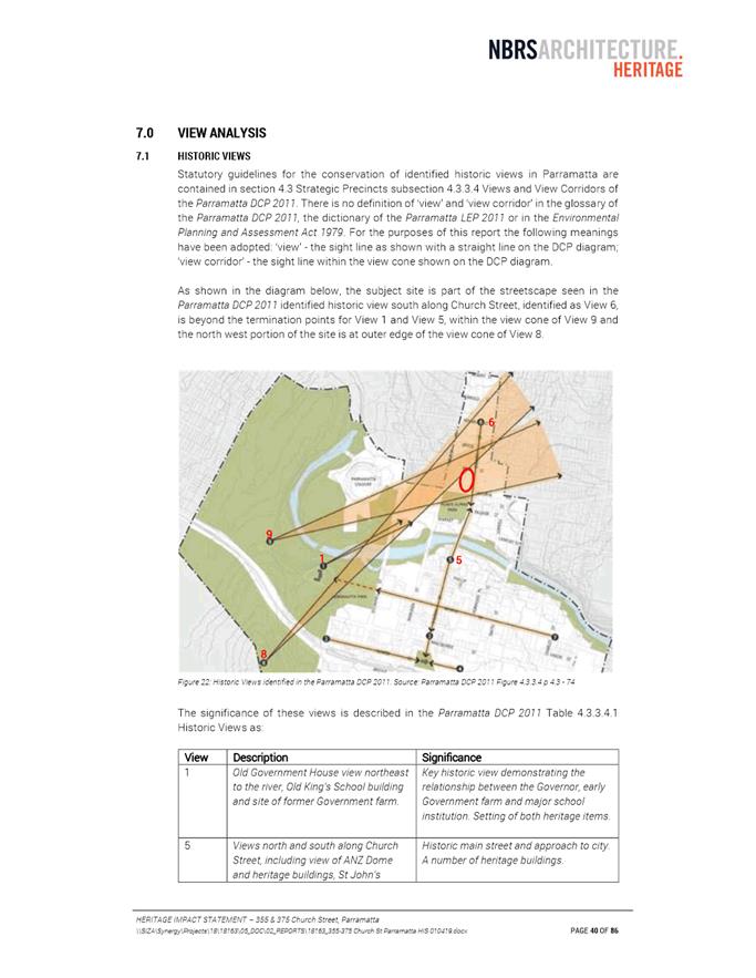
Item 5.1 - Attachment 1 |
Attachment 1: Assessment Report |
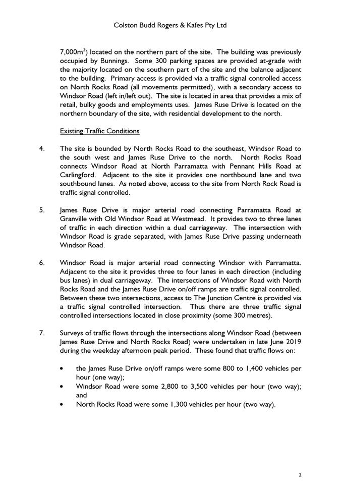
NOTICE OF Local Planning Panel MEETING
PUBLIC AGENDA
An Ordinary Local Planning Panel will be held remotely via audio-visual link, Tuesday, 16 June 2020 at 3.30pm.
Brett Newman
CHIEF EXECUTIVE OFFICER
THIS PAGE LEFT BLANK INTENTIONALLY
Local Planning Panel 16 June 2020
TABLE OF CONTENTS
ITEM SUBJECT PAGE NO
1 ACKNOWLEDGMENT OF THE TRADITIONAL LAND OWNERS
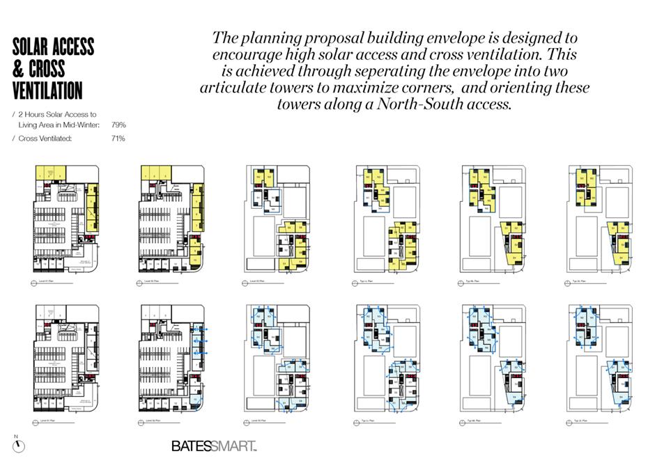
The City of Parramatta Council acknowledges the Burramattagal Clan of The Darug, the traditional land owners of Parramatta and pays its respects to the elders both past and present
2 WEBCASTING ANNOUNCEMENT
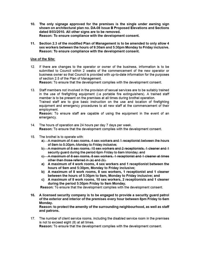
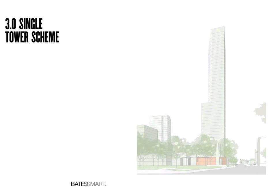
This public meeting will be recorded. The recording will be archived and available on Council’s website.
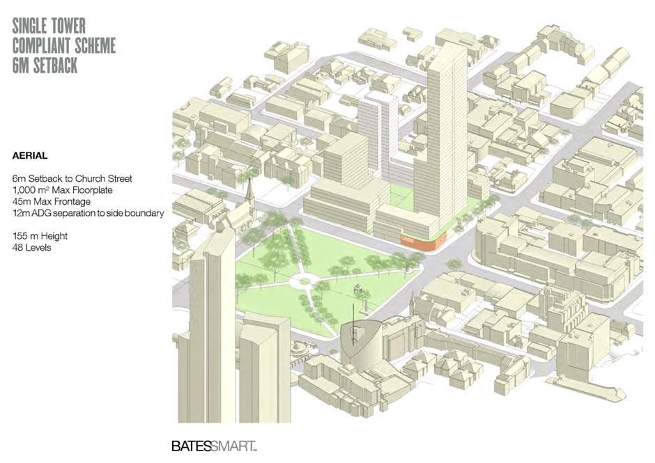
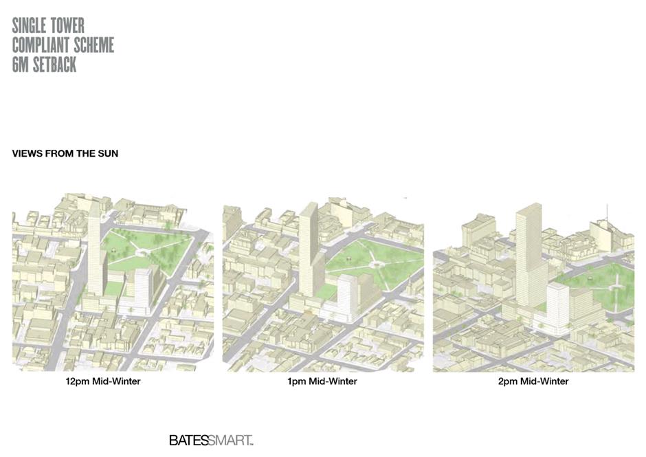
All care is taken to maintain your privacy; however if you are in attendance in the public gallery, you should be aware that your presence may be recorded.
3 APOLOGIES
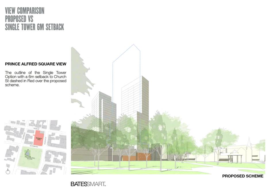
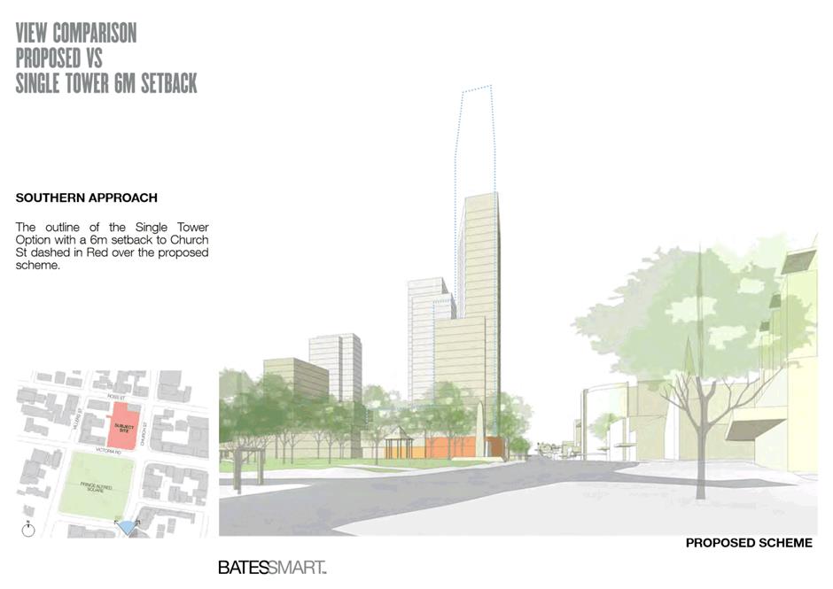
4 DECLARATIONS OF INTEREST
5 Reports - Development Applications
5.1 5
Yarbon Street, Wentworthville NSW 2145
(Lot 151 DP 8850)..................................................................................... 6
5.2 49
Rawson Street, Boronia Park (R88719) & 37A Bridge Street, EPPING NSW 2121
(Lot 2 DP 516659, Lot 341 DP 914533, Lot 3332 DP 914534)...... 49
5.3 19 Brodie Street, Rydalmere (Lot 180 DP 14244).......................... 109
5.4 15 Pearl Avenue, Epping (Lot 18 in DP 18720).............................. 157
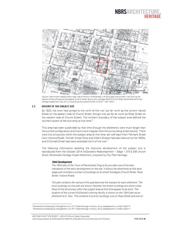
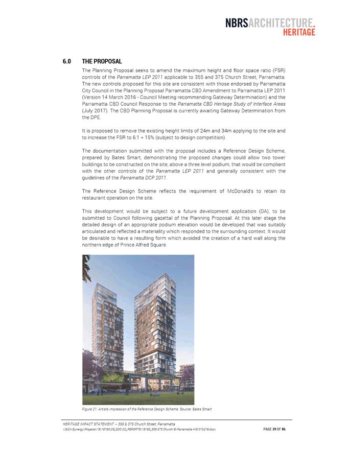
6.1 Pre-Gateway: Planning Proposal for land at 355 and 375 Church St, Parramatta............................................................................................. 206
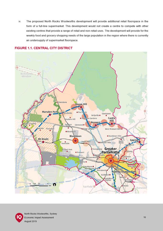
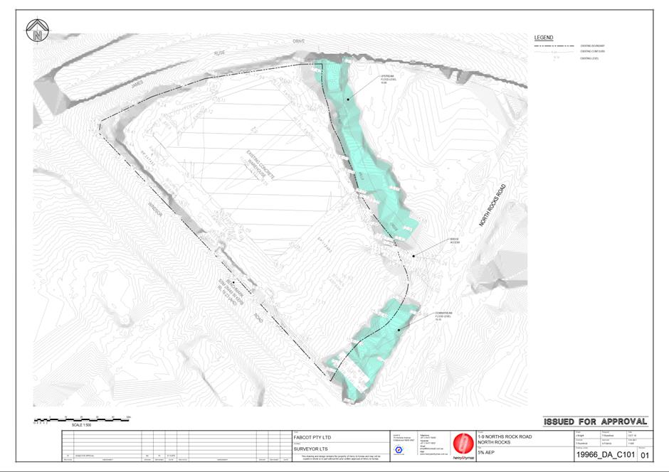
6.2 Pre-Gateway: Planning Proposal for land at 1 Windsor Road, North Rocks 503
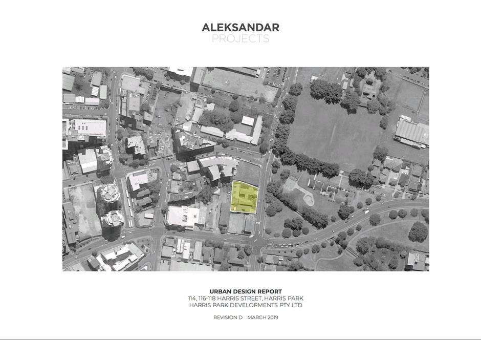
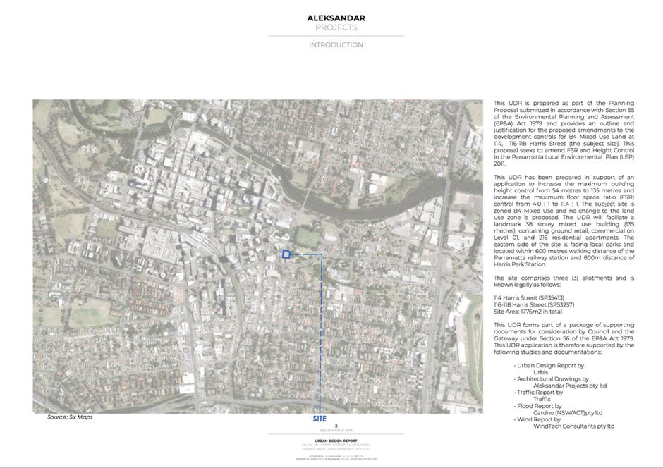
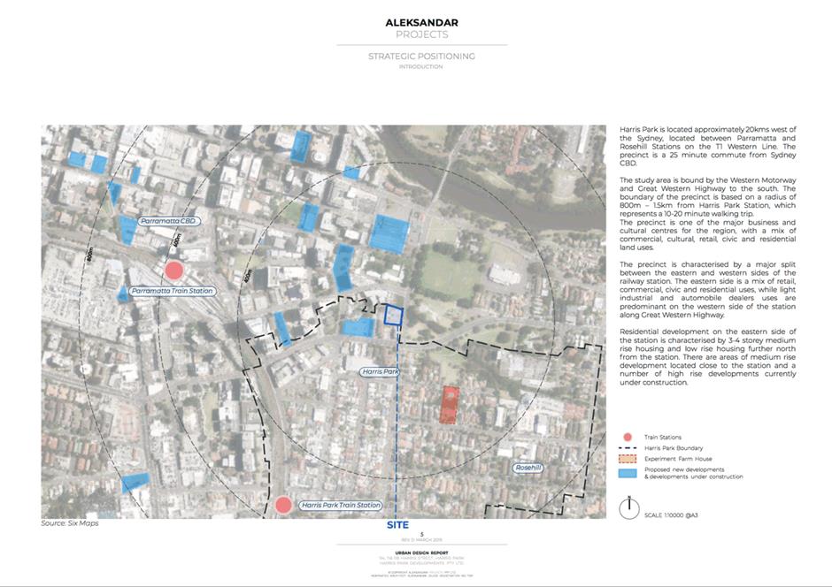
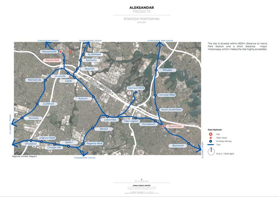
6.3 Pre-Gateway: Planning Proposal for land at 114-118 Harris Street, Harris Park......................................................................................................... 657
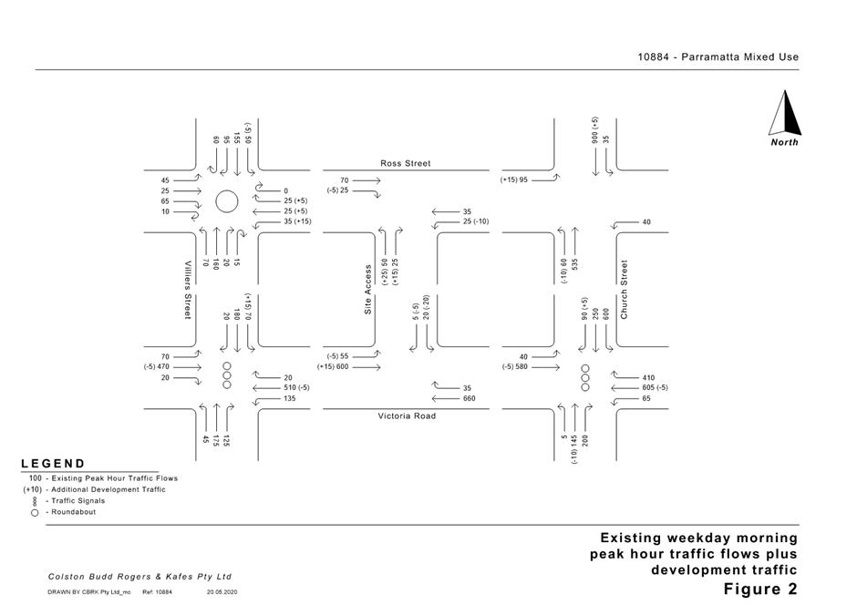
Development Applications
16 June 2020
5.1 5
Yarbon Street, Wentworthville NSW 2145
(Lot 151 DP 8850).............................................................................................. 6
5.2 49
Rawson Street, Boronia Park (R88719) & 37A Bridge Street, EPPING NSW 2121
(Lot 2 DP 516659, Lot 341 DP 914533, Lot 3332 DP 914534)................ 49
5.3 19 Brodie Street, Rydalmere (Lot 180 DP 14244)................................... 109
5.4 15 Pearl Avenue, Epping (Lot 18 in DP 18720)........................................ 157
Local Planning Panel 16 June 2020 Item 5.1
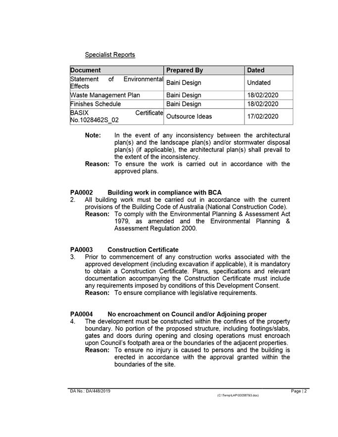
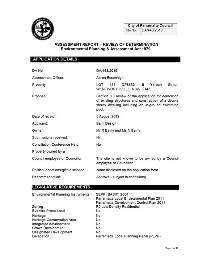
ITEM NUMBER 5.1
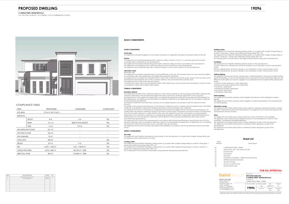
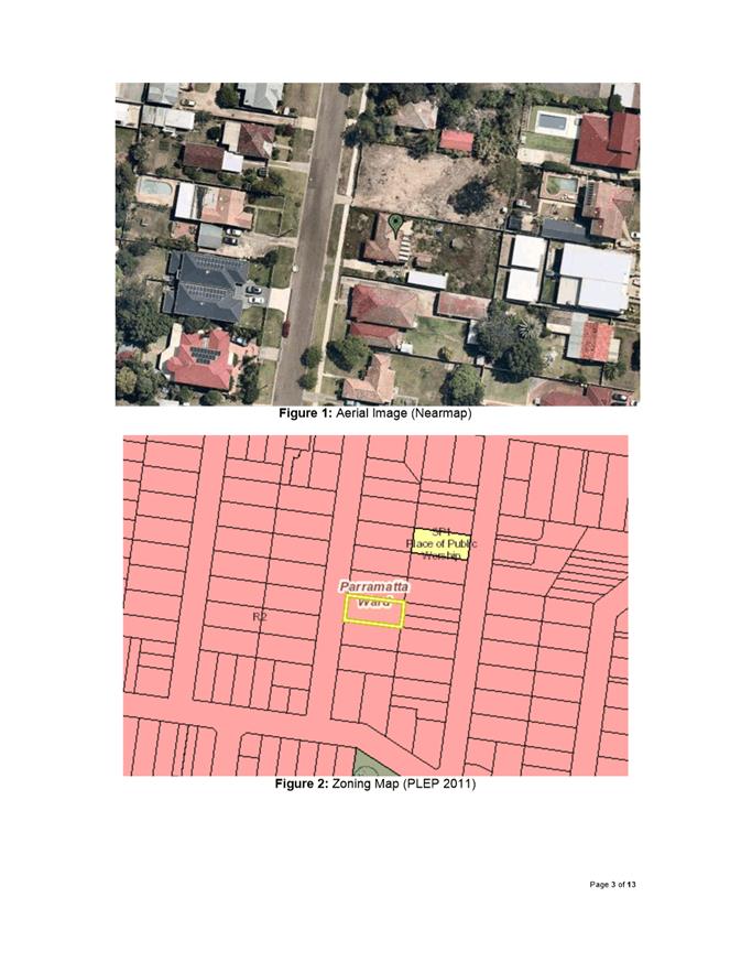
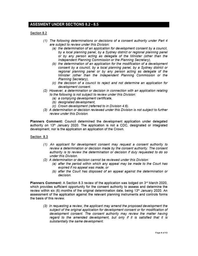
SUBJECT 5 Yarbon Street, Wentworthville NSW 2145
(Lot 151 DP 8850)
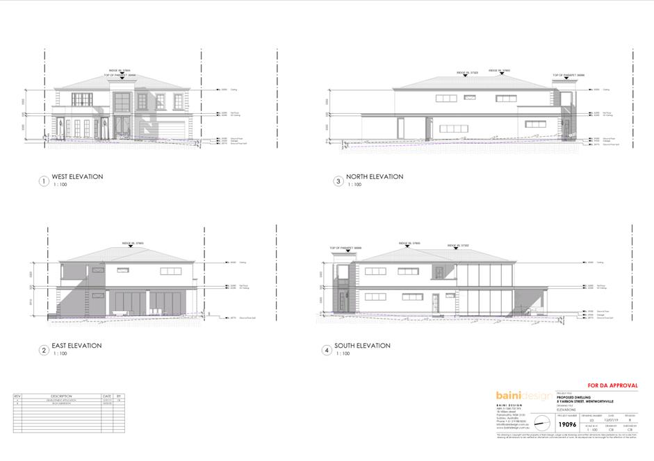
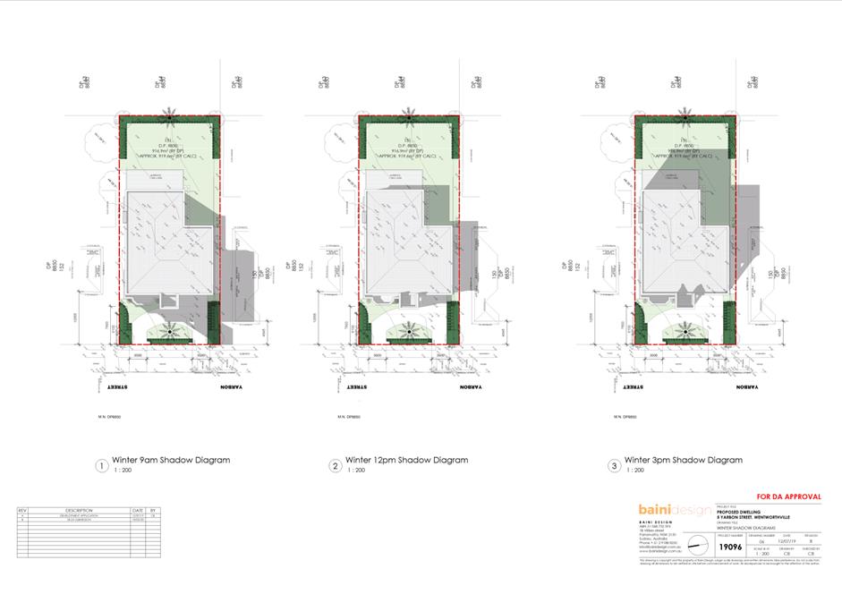
DESCRIPTION Section 8.3 Review for demolition of existing structures and construction of a double-storey dwelling including an in-ground swimming pool.
REFERENCE DA/448/2019 -
APPLICANT/S Baini Design
OWNERS Mr R Bainy, Ms N Bainy
REPORT OF Group Manager Development and Traffic Services
|
DATE OF REPORT 16 June 2020
REASON FOR REFERRAL TO LPP
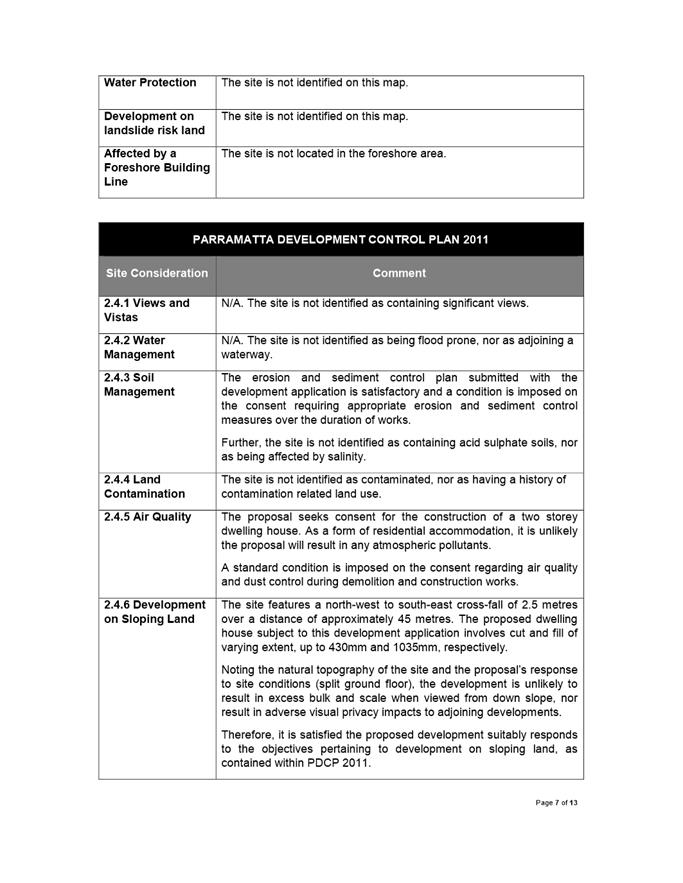
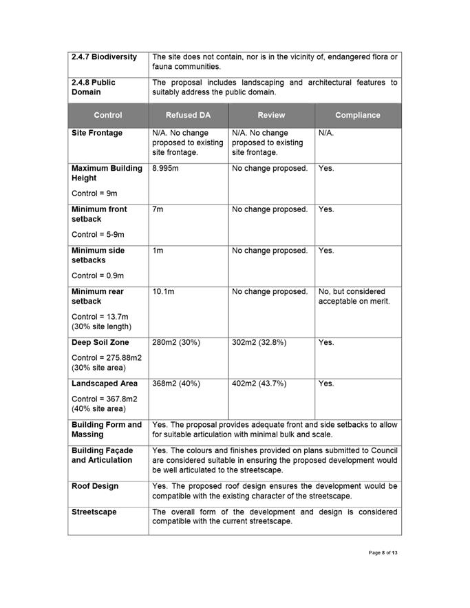
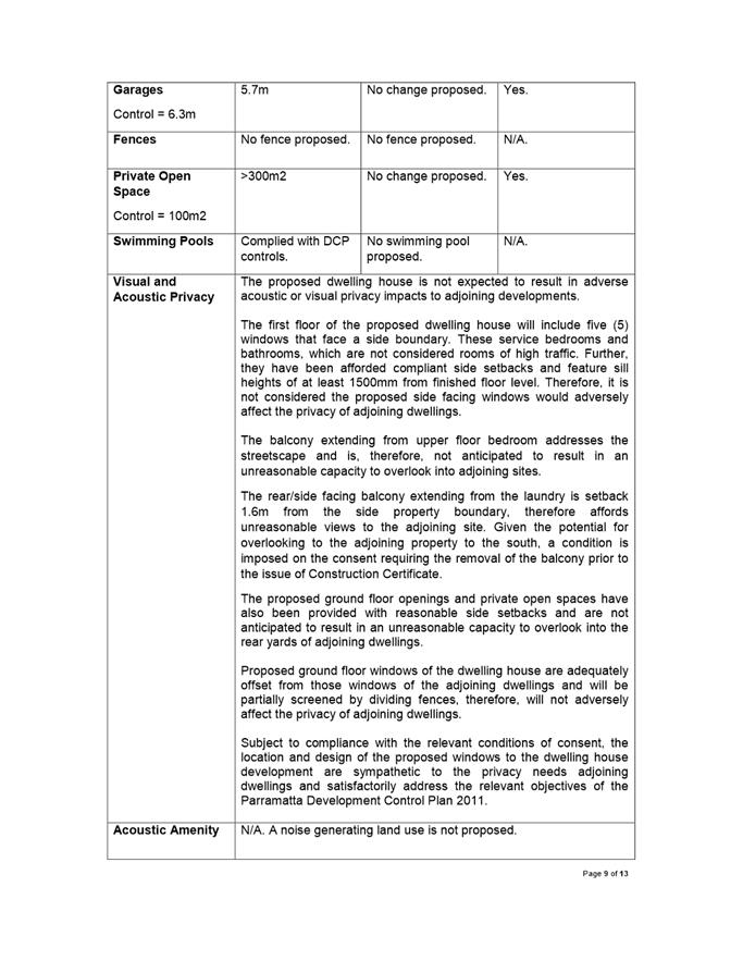
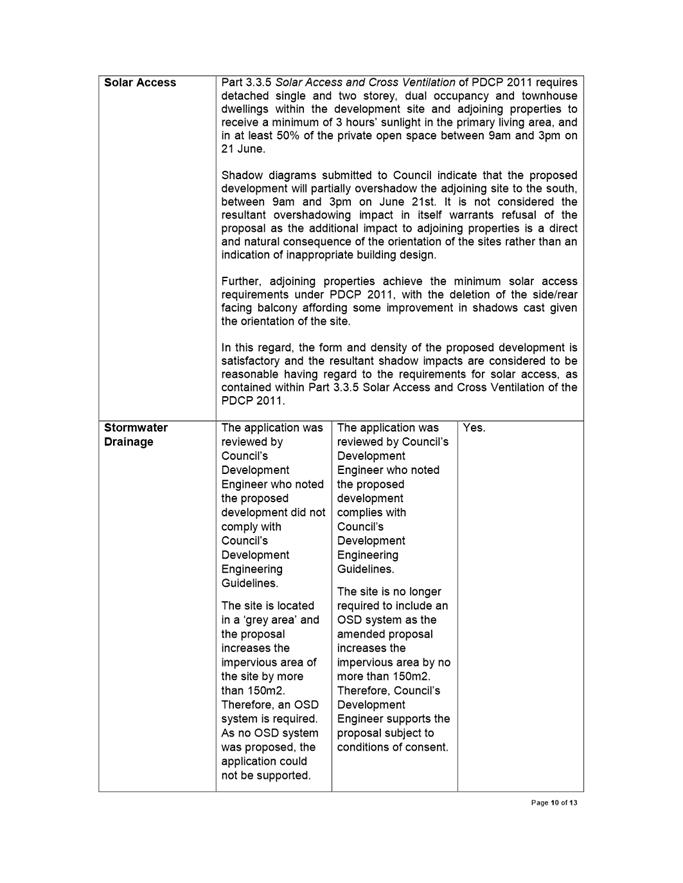
The application involves a Review of Determination of DA/448/2019, pursuant to Section 8.3 of the Environmental Planning and Assessment Act, 1979.
EXECUTIVE SUMMARY
Site Details
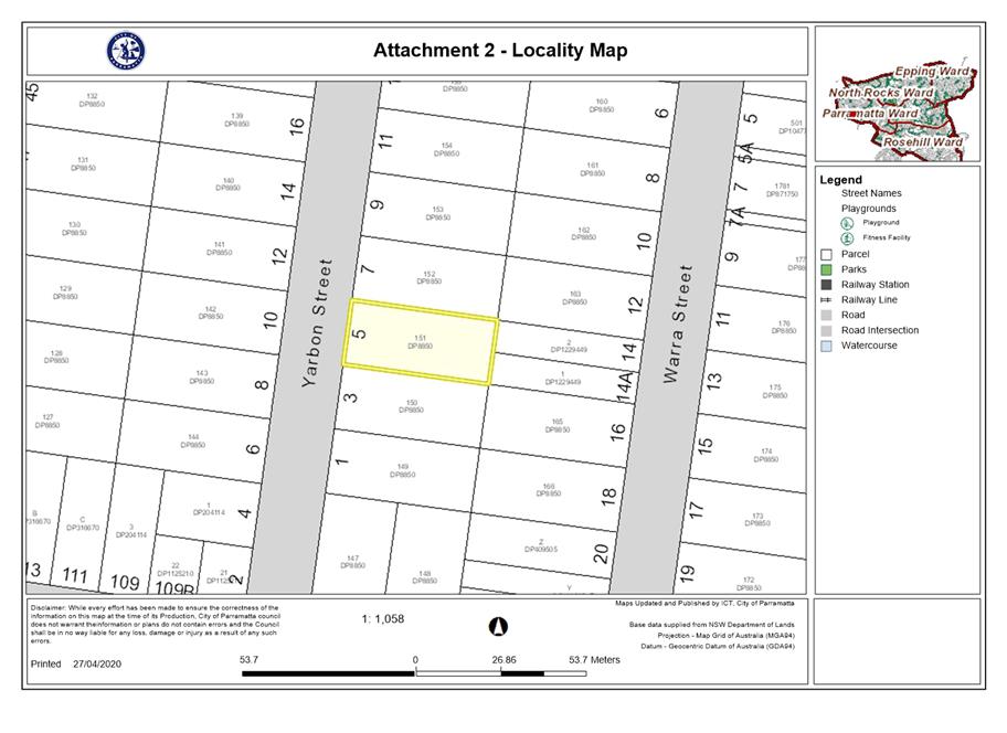
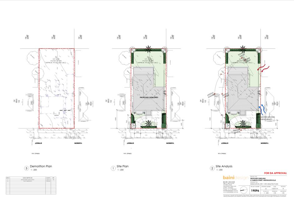
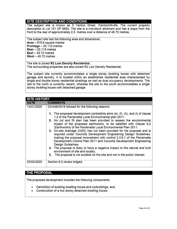
The subject site is known as 5 Yarbon Street, Wentworthville (Lot 151, DP 8850). The subject site currently accommodates a single storey dwelling house with detached garage and laundry. It is located within an established residential area characterised by single and double storey residential dwellings as well as dual occupancy developments. The site to the north is currently vacant, whereas the site to the south accommodates a single storey dwelling house with detached garage.
The site is zoned R2 Low Density Residential under the Parramatta Local Environmental Plan 2011. Adjoining properties are also zoned R2 Low Density Residential.
Background
The application was refused under delegated authority on 13th January 2020. The reasons for refusal were as follows:
1. The proposed development contradicts aims (e), (f), (h), and (l) of clause 1.2 of the Parramatta Local Environmental plan 2011.
2. No cut and fill plan has been provided to assess the environmental impact of the proposed earthworks, to be satisfied with Clause 6.2 (Earthworks) of the Parramatta Local Environmental Plan 2011.
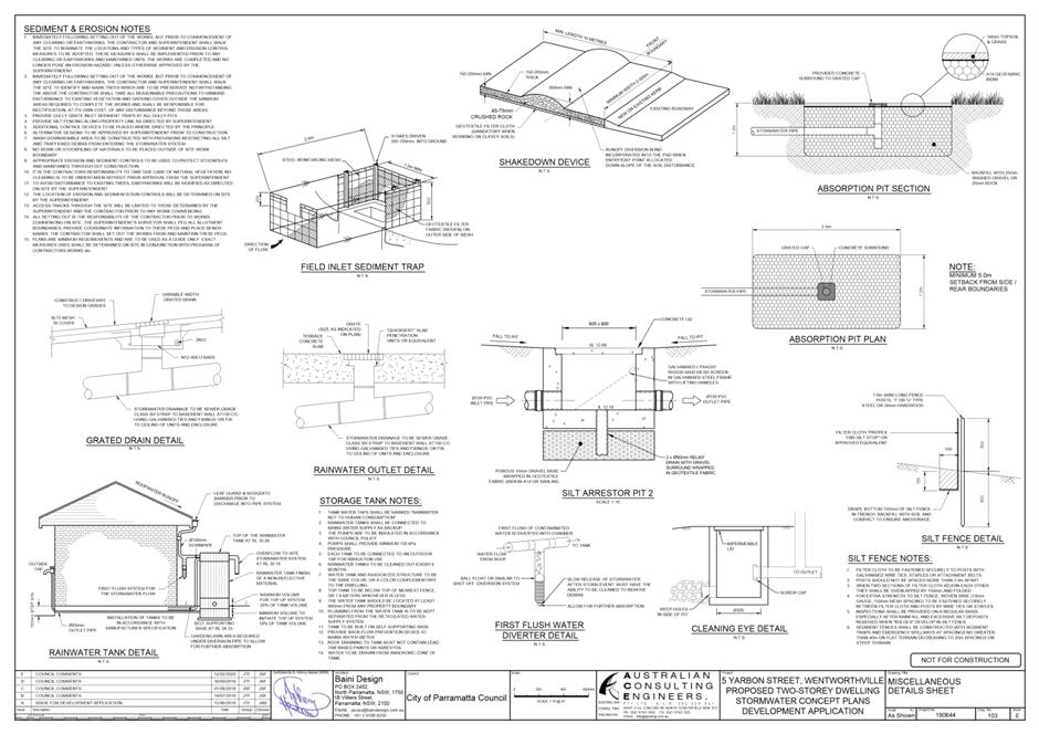
3. On-site drainage (OSD) has not been provided for the proposal and is required under Councils Development Engineering Design Guidelines, making the proposal inconsistent with control 3.3.6.1 of the Parramatta Development Control Plan 2011 and Councils Development Engineering Design Guidelines.
4. The proposal is likely to have a negative impact to the natural and built environment of site and locality.
5. The proposal is not suitable on the site and not in the public interest.
Pursuant to Section 8.3 of the Environmental Planning and Assessment Act 1979, a Review of Determination was submitted with revised supporting documentation. It is considered the revised documentation has sufficiently responded to the concerns raised by Council during the assessment of the original application.
Proposed Development
The proposed development includes the following components:
· Demolition of existing dwelling house and outbuildings; and, · Construction of a two storey detached dwelling house.
Additional information has been provided and amendments made to the proposal as follows:
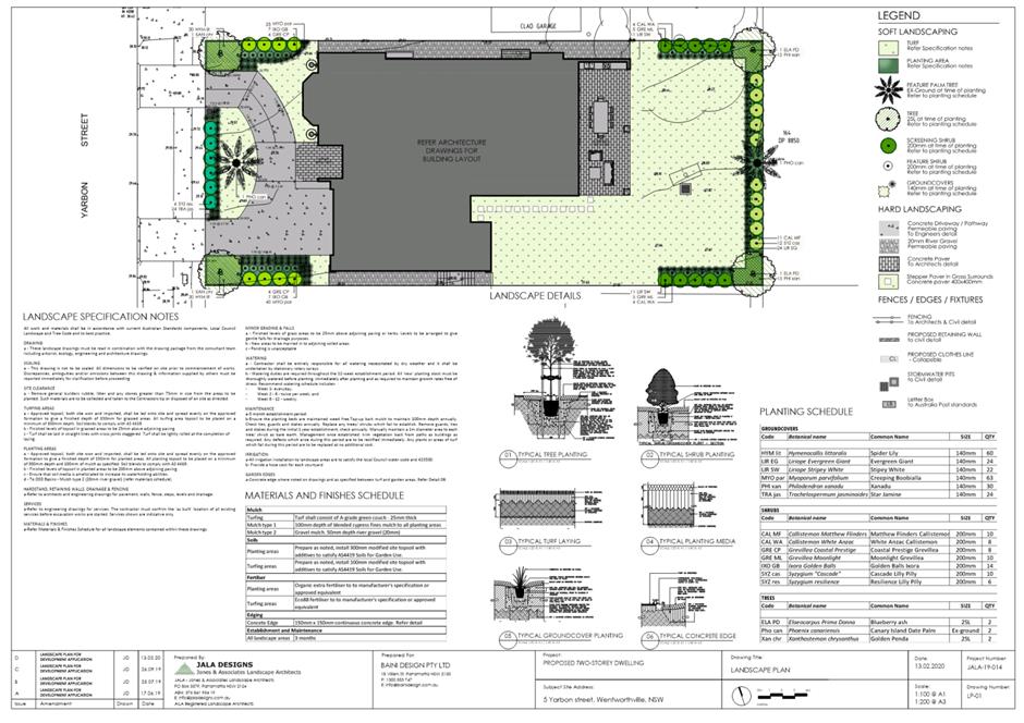
· Updated BASIX Certificate; · Updated Statement of Environmental Effects; · Architectural plans showing the extent of earthworks, a smaller alfresco and removal of swimming pool; and, · Concept Stormwater Plan reflecting changes made in architectural plans.
The development application was advertised between 11th and 25th March 2020 in accordance with the advertisement procedures contained within Appendix 5 of the Parramatta Development Control plan 2011. No submissions were received
The application was referred to Council’s Development Engineer and Tree Management and Landscape Officer. All raised no objection to the proposed development subject to conditions imposed on the consent. In particular, Council’s Development Engineer notes the site does not require OSD as the proposed development increases the impervious area by no more than 150 square metres.
The proposal has been assessed in accordance with Section 4.15 (1) of the Environmental Planning and Assessment Act, 1979. The proposed development is consistent with the requirements of both the Parramatta Local Environmental Plan 2011 and Parramatta Development Control Plan 2011.
The proposal is permissible in the R2 Low Density Residential zone and results in a development which is suitable in the context of the locality and future desired character of the area. A merit based assessment has determined the proposal is satisfactory, responds suitability to the unique constraints of the site and is in the public interest. Accordingly, the application is recommended for approval subject to conditions of consent. |
|
That the Parramatta Local Planning Panel (PLPP) exercising the functions of Council, pursuant to Section 4.16 of the Environmental Planning and Assessment Act, 1979, grant development consent to DA/448/2019 for a period of five (5) years within which physical commencement is to occur from the date on the Notice of Determination, subject to conditions of consent within Attachment 1.
|
Aaron Essenhigh
Development Assessment Officer
|
1⇩ |
Attachment 1: Assessment Report |
13 Pages |
|
|
2⇩ |
Attachment 2: Locality Map |
1 Page |
|
|
3⇩ |
Attachment 3: Plans used during assessment |
6 Pages |
|
|
Attachment 4: Internal plans used during assessment (confidential) |
4 Pages |
|
|
|
5⇩ |
Attachment 5: Conditions |
20 Pages |
|
REFERENCE MATERIAL
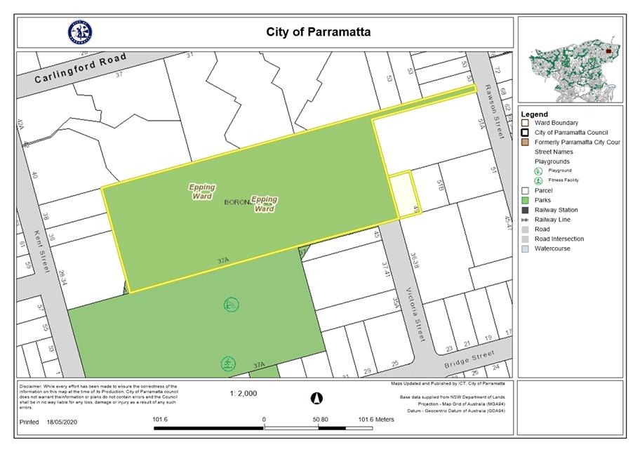
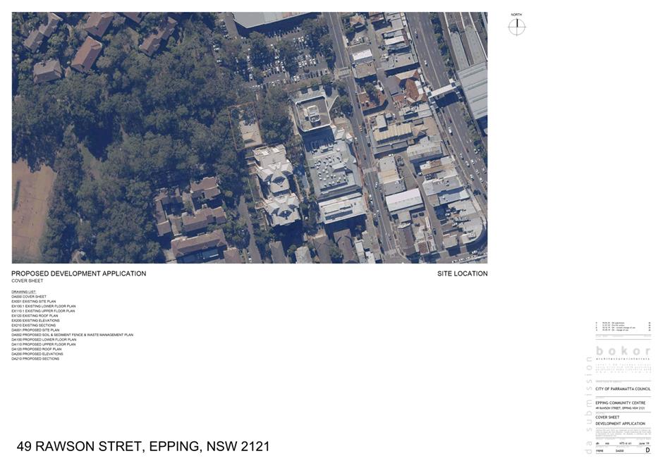
ITEM NUMBER 5.2
SUBJECT 49 Rawson Street, Boronia Park (R88719) & 37A Bridge Street,
EPPING NSW 2121
(Lot 2 DP 516659, Lot 341 DP 914533, Lot 3332 DP 914534)
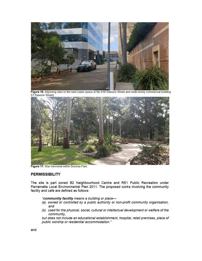
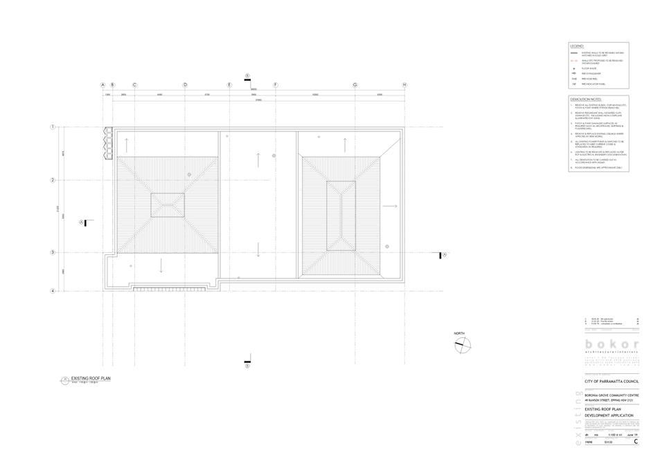
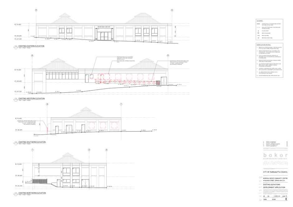
DESCRIPTION Alterations and additions to an approved community facility and part use for a café, internal works, construction of a partially covered deck, accessible ramps, bin storage and tree removal.
REFERENCE DA/107/2020 -
APPLICANT/S Bokor Architecture & Interiors
OWNERS City of Parramatta
REPORT OF Group Manager Development and Traffic Services
|
DATE OF REPORT 18 May 2020
REASON FOR REFERRAL TO LPP
The application is being referred to the Parramatta Local Planning Panel as the land owner is the City of Parramatta Council.
EXECUTIVE SUMMARY
This is a summary of the full assessment of the application as outlined in Attachment 1, the Section 4.15 Assessment Report. Noting the ownership of the development site, the subject application had been assessed by an independent planning consultant.
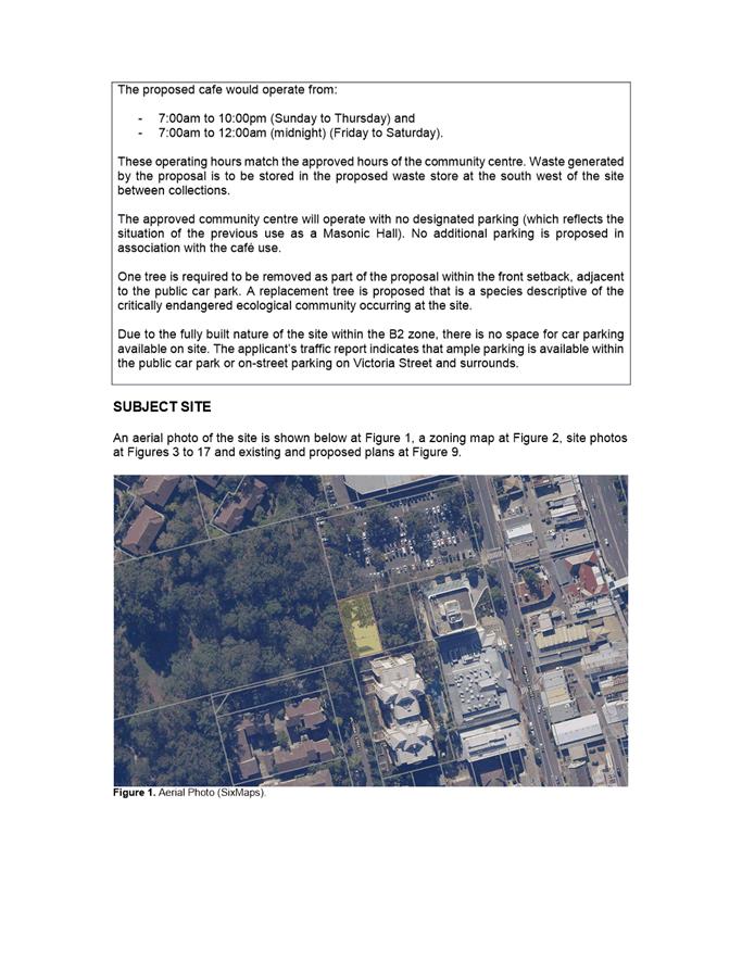
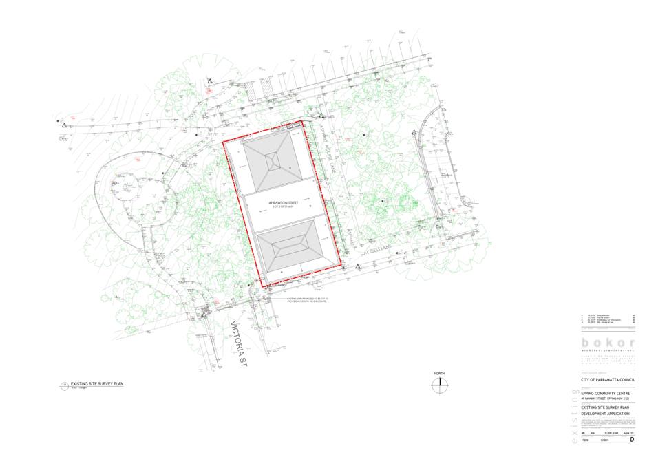
The subject Development Application proposes the part use of the approved Epping Community Centre for a café with an associated raised deck and access path to be constructed within Boronia Park which is immediately adjacent to the community centre building. At the northern setback of the community centre, adjacent to the large public car park on Rawson Street, additional access paths will be created to the lower ground level of the building. The proposal also involves internal and external alterations to the existing building including accessible entries, partition walls and additional windows to the southern and eastern elevations.
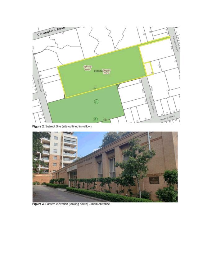
The subject development site comprises No.49 Rawson Street and No.37A Bridge Street, Epping and includes part of Boronia Park. The legal descriptions of the lots are Lot 2 DP 516659 and Lot B DP 160976 for the Community Centre and Boronia Park respectively. The total site area of the Community Centre and Boronia Park is approximately 4.2 hectares.
The development site is part zoned B2 Local Centre and RE1 Public Recreation under the Parramatta Local Environmental Plan 2011. The proposal for the purposes of a Community Facility and Café are permitted with consent on both of the zones.
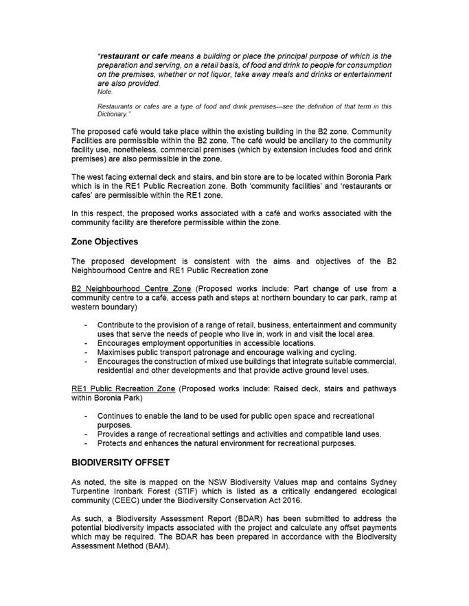
The site is regular in shape and accommodates a two storey Community Centre with a recent approval to operate as such under DA/621/2019. Boronia Park is a large local park located to the rear and includes wooded areas, a War Memorial, children’s playground, BBQ and picnic area and a sports field. Only a very small part of the park immediately adjacent to the Community Centre is included in the subject site that would accommodate a raised deck and ramp and pedestrian access point.
The subject development site is located within the Epping Town Centre which is undergoing change and is characterised as an established built up area with a range of residential and commercial uses where a change to higher density mixed use development is evident.
Boronia Park is mapped on the NSW Biodiversity Values map and contains Sydney Turpentine Ironbark Forest (STIF), which is listed as a ‘critically endangered ecological community’ (CEEC) under the Biodiversity Conservation Act 2016. It is proposed to remove and replace one tree known as ‘a Sydney Red Gum.’
The application was reviewed by Council’s Development Engineer, Traffic Engineer, Tree Landscape Officer, Biodiversity Planning Officer, Assets Officer, Property Services Team and the Environmental Health Team. No concerns were raised subject to the imposition of conditions
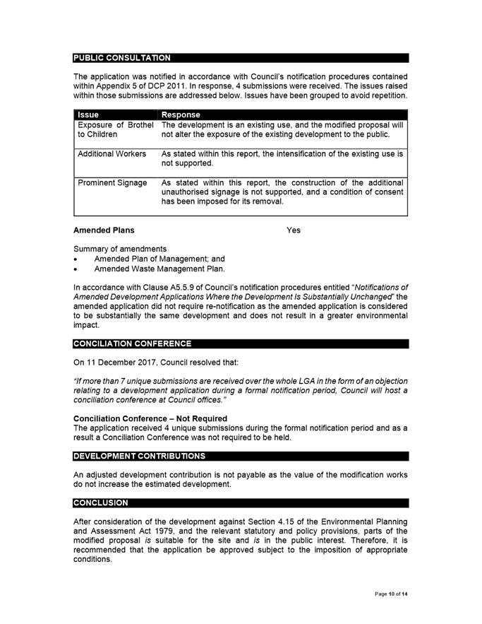
The subject application was placed on public advertising and neighbour notification from 18 March 2020 to 8 April 2020. A total of four (4) unique submissions were received in response to the proposal. The key issues raised in the submissions include the impact on trees and vegetation, traffic and parking, waste management and noise impacts. The issues have been satisfactorily addressed and do not warrant the refusal of the application.
The development is consistent with the provisions contained in the Parramatta Local Environmental Plan 2011 and the Parramatta Development Control Plan 2011.
The proposed development is considered to be satisfactory and notwithstanding the issues raised in the submissions, the application is recommended for approval, subject to the imposition of conditions.
|
|
(a) That the Parramatta Local Planning Panel, exercising the functions of the Council as the consent authority pursuant to the provisions of Section 4.16 of the Environmental Planning and Assessment Act 1979, grant development consent to DA/107/2020 for a period of five (5) years within which physical commencement is to occur from the date on the Notice of Determination.
(b) That all the objectors be advised of the Parramatta Local Planning Panel’s decision. |
Steven Chong
Team Leader Development Assessment
|
1⇩ |
Attachment 1: Section 4.15 Assessment Report |
24 Pages |
|
|
2⇩ |
Attachment 2: Recommended Conditions of Consent |
24 Pages |
|
|
3⇩ |
Attachment 3: Locality Map |
1 Page |
|
|
4⇩ |
Attachment 4: Architectural Plans |
9 Pages |
|
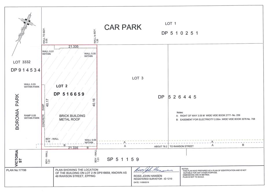
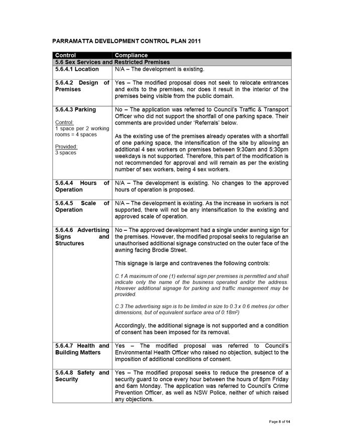
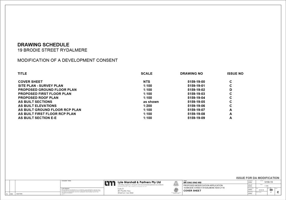
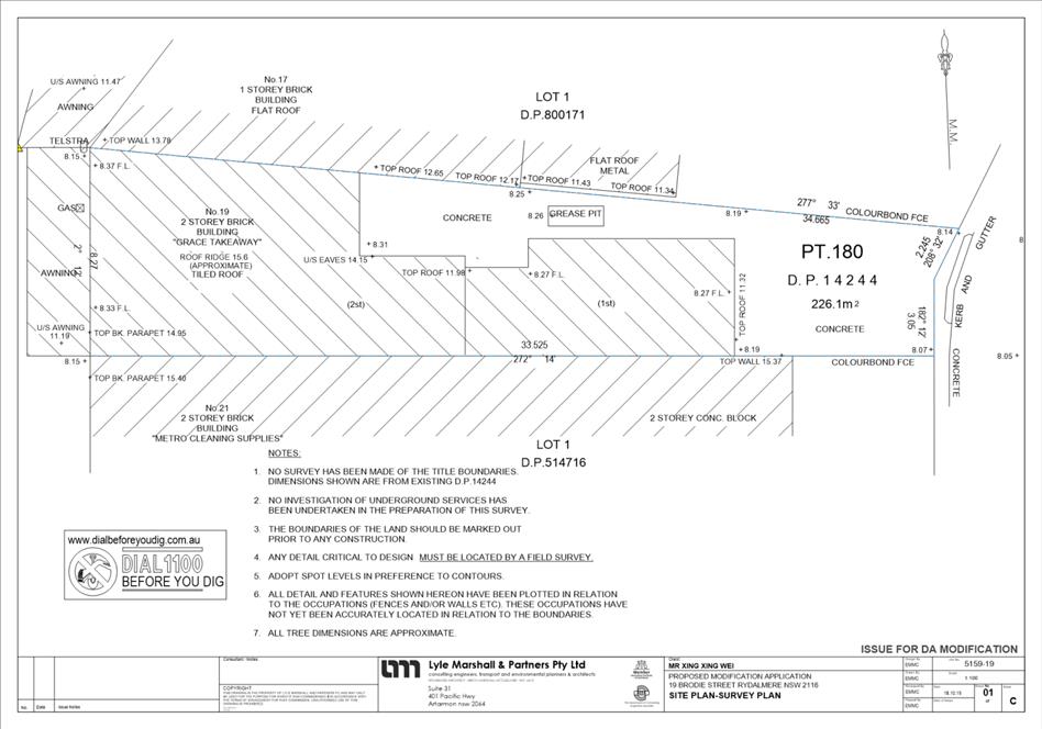
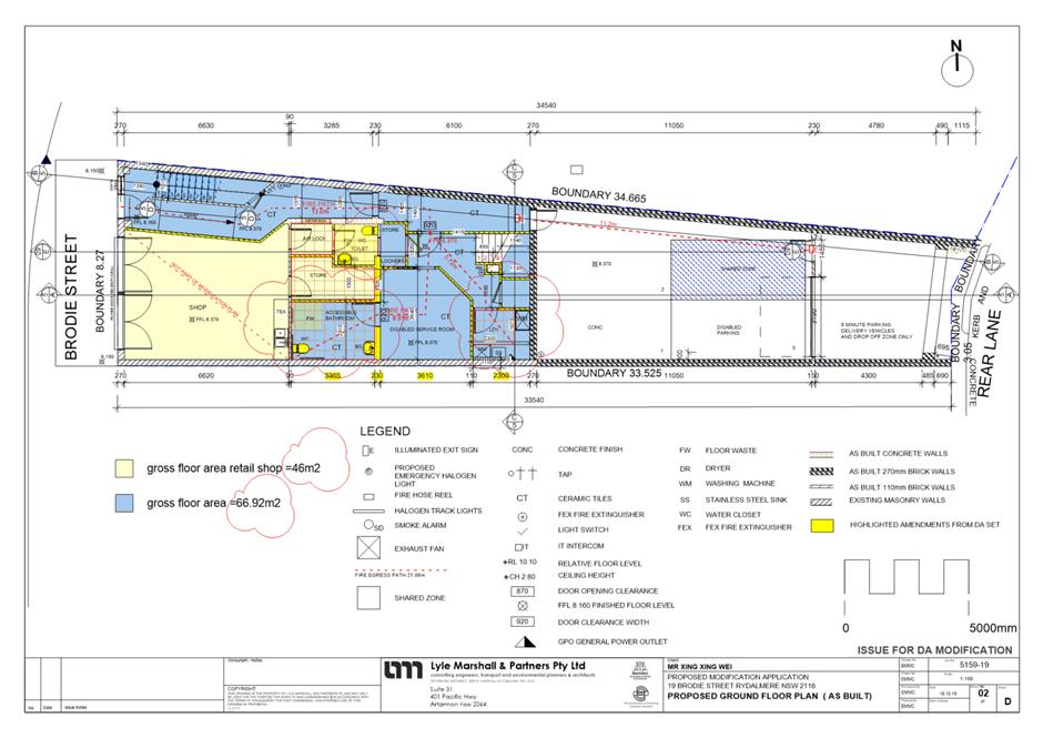
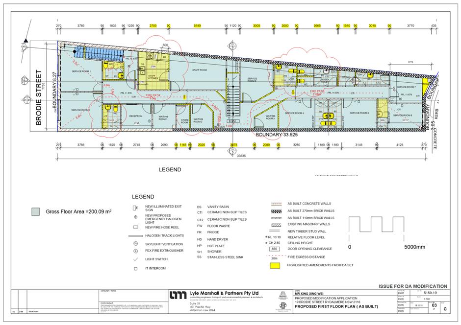
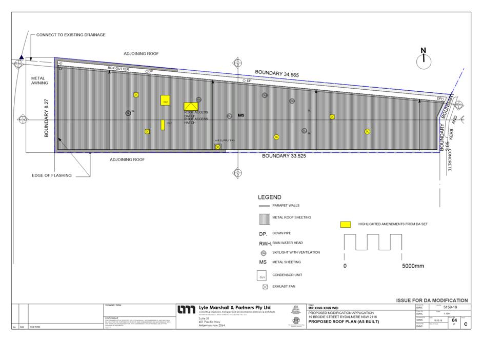
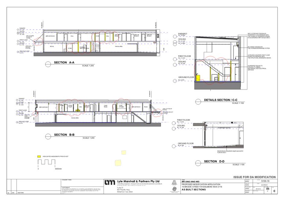
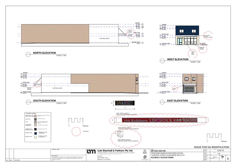
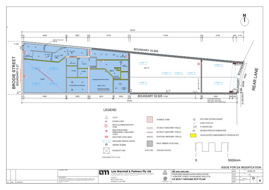
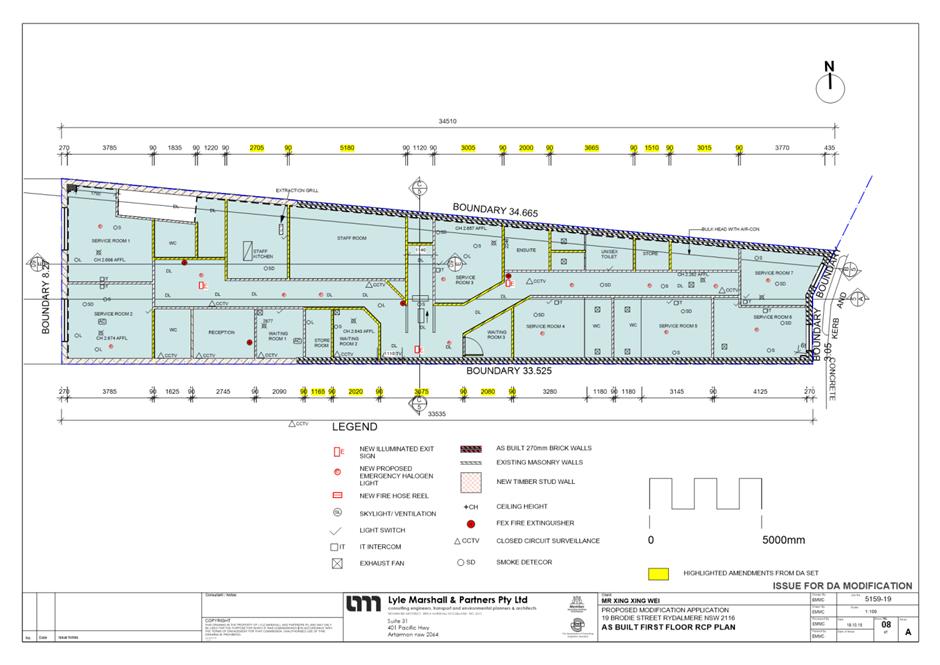
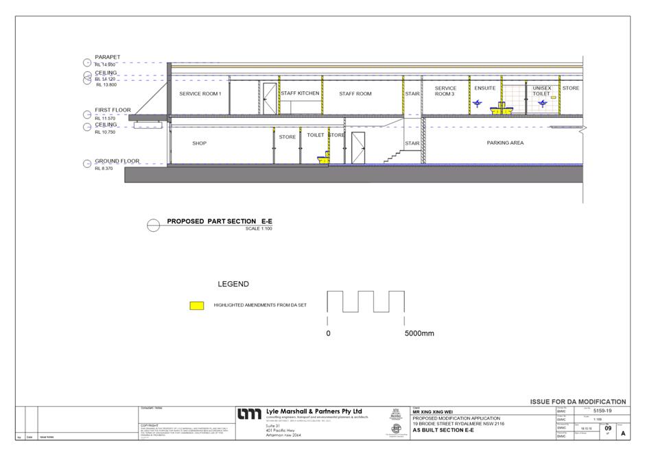
ITEM NUMBER 5.3
SUBJECT 19 Brodie Street, Rydalmere (Lot 180 DP 14244)
DESCRIPTION Section 4.56 modification to DA/513/2009 for alterations and additions to a commercial building which contains an approved brothel and a take away shop. Proposed modifications include alterations to the internal layout, hours of operation and number of staff.
REFERENCE DA/513/2009/A -
APPLICANT/S Mr X X Wei
OWNERS Mr X X Wei and Ms M D F Xu
REPORT OF Group Manager Development and Traffic Services
|
DATE OF REPORT 27 May 2020
REASON FOR REFERRAL TO LPP
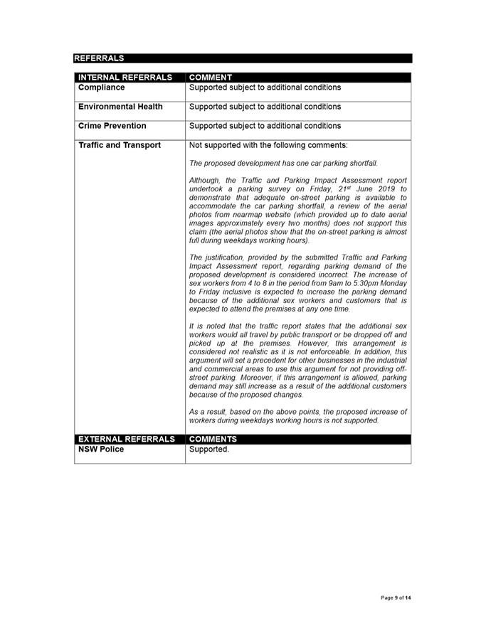
This S4.56 Modification is being referred to Parramatta Local Planning Panel because it involves a Sex Services Premises.
EXECUTIVE SUMMARY
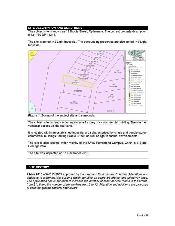
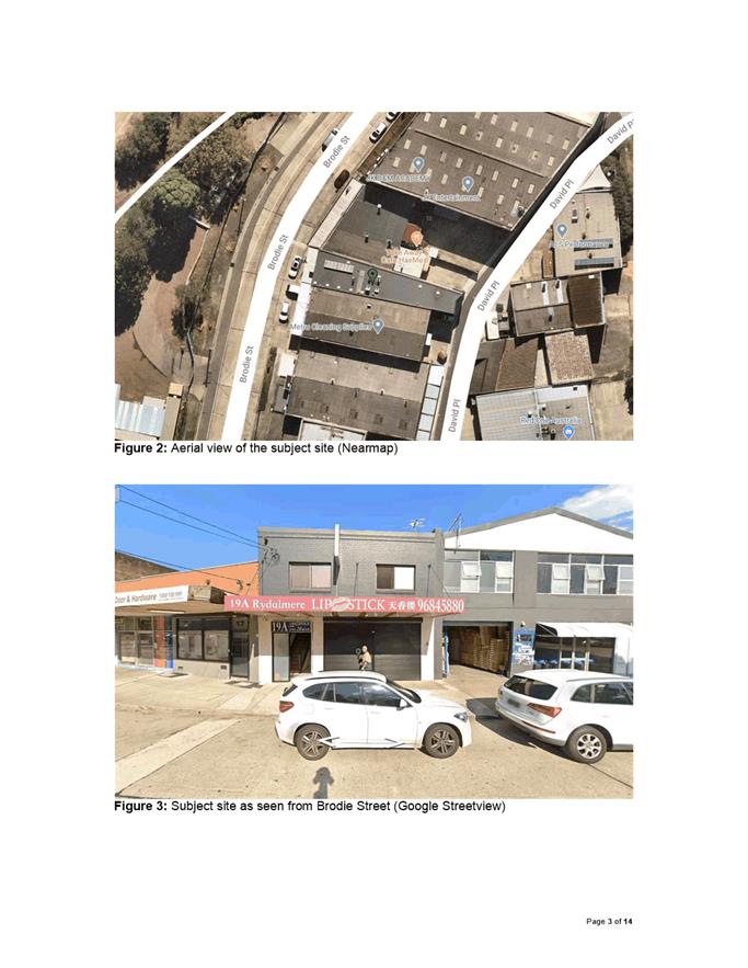
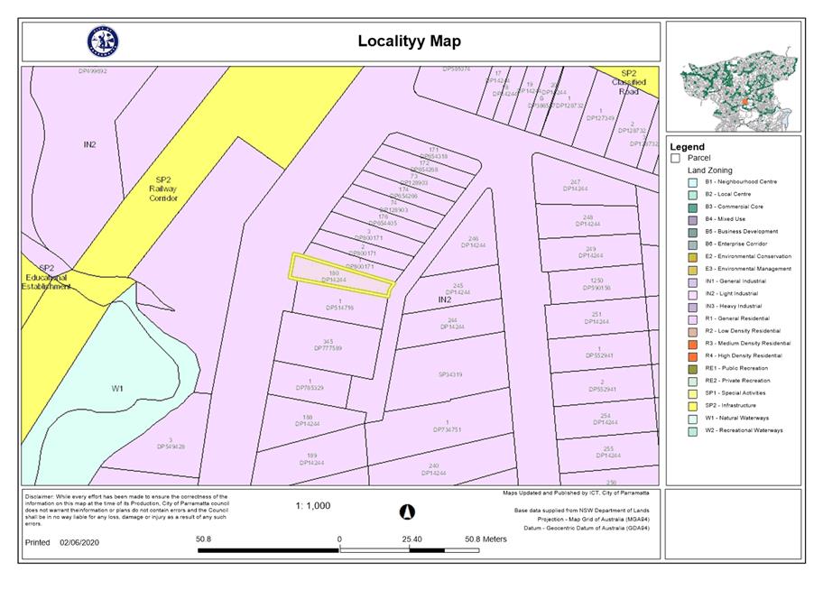
The subject site is known as 19 Brodie Street, Rydalmere. The current property description is Lot 180 DP 14244. The site is zoned IN2 Light Industrial. The surrounding properties are also zoned IN2 Light Industrial.
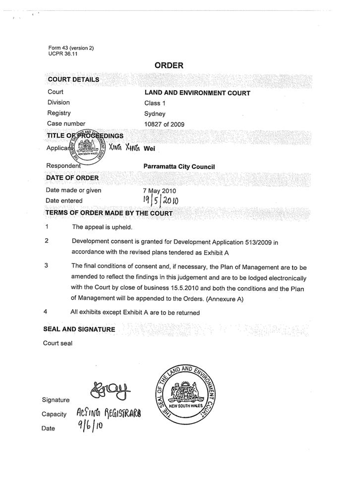
The subject site supports an existing brothel, approved by the Land and Environment Court under DA/513/2009 for ‘Alterations and additions to a commercial building which contains an approved brothel and takeaway shop. The application seeks approval to increase the number of client service rooms in the brothel from 2 to 8 and the number of sex workers from 2 to 12. Alteration and additions are proposed at both the ground and first floor levels’.
This modified proposal seek consent for the following:
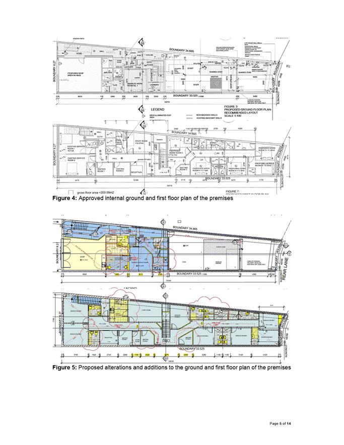
1. Internal alterations to the ground floor and first floor. Alterations are generally for relocation of internal walls and does not result in any additional GFA;
2. Modify the following condition:
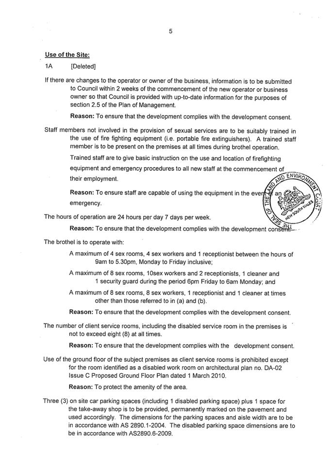
The brothel is to operate with: a) A maximum of 4 sex rooms, 4 sex workers and 1 receptionist between the hours of 9am to 5:30pm, Monday to Friday inclusive; b) A maximum of 8 sex rooms, 10 sex workers and 2 receptionists, 1 cleaner and 1 security guard during the period 6pm Friday to 6am Monday; and c) A maximum of 8 sex rooms, 8 sex workers, 1 receptionist and 1 cleaner at times other than those referred in (a) and (b). Reason: To ensure that the development complies with the development consent.
To read as follows:
The brothel is to operate with: a) A maximum of 4 work rooms, 8 sex workers and 1 receptionist between the hours of 9am and 5:30pm, Monday to Friday inclusive; b) A maximum of 8 work rooms, 8 sex workers, 1 receptionist and 1 cleaner between the hours of 5:30pm to 9am, Monday to Friday inclusive; and c) A maximum of 8 work rooms, 10 sex workers, 2 receptionists and 1 cleaner during the period 5:30pm Friday to 9am Monday. Reason: To ensure that the development complies with the development consent.
With the inclusion of the following additional condition:
A licensed security company is to be engaged to provide a security guard patrol of the exterior and interior of the premises every hour between 8pm Friday to 6am Monday. Reason: to protect the amenity of the surrounding neighbourhood, as well as staff and patrons.
3. Regularise unauthorised signage constructed on the outer face of the awning fronting Brodie Street.
In addition to the modifications requested by the applicant above, the original Conditions of Consent for DA/513/2009 issued by the Land and Environment Court did not number the conditions. Council will use this modified proposal as an opportunity to number each condition for ease of future reference.
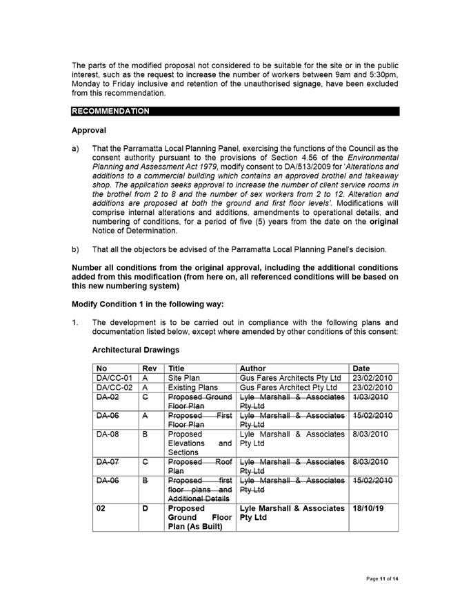
Following a merit assessment of the modified proposal, the intensification of the site by allowing an additional 4 sex workers on premises between 9:30am and 5:30pm weekdays is not supported, as the existing approval already operates with a shortfall in onsite parking. Therefore, this part of the modification is not recommended for approval and will remain as per the existing number of sex workers, being 4 sex workers.
Additionally, the unauthorised signage is also not supported as it contravenes controls within the DCP.
Accordingly, the modified proposal is recommended for approval, with slight amendments to the conditions, as well as the addition of a number of new conditions relating to waste management, and operational management. A complete list of the proposed conditions of consent to be imposed can be viewed under the attachments below.
|
|
(a) That the Parramatta Local Planning Panel, exercising the functions of the Council as the consent authority pursuant to the provisions of Section 4.56 of the Environmental Planning and Assessment Act 1979, modify consent to DA/513/2009 for ‘Alterations and additions to a commercial building which contains an approved brothel and takeaway shop. The application seeks approval to increase the number of client service rooms in the brothel from 2 to 8 and the number of sex workers from 2 to 12. Alteration and additions are proposed at both the ground and first floor levels’. Modifications will comprise internal alterations and additions, amendments to operational details, and numbering of conditions, for a period of five (5) years from the date on the original Notice of Determination.
(b) Further, that all the objectors be advised of the Parramatta Local Planning Panel’s decision. and recommendations first.
|
Darren Wan
Senior Development Assessment Officer
|
1⇩ |
Attachment 1: Assessment Report |
14 Pages |
|
|
2⇩ |
Attachment 2: Locality Map |
1 Page |
|
|
3⇩ |
Attachment 3: Plans used during assessment |
10 Pages |
|
|
4⇩ |
Attachment 4: Original conditions issued by LEC |
12 Pages |
|
|
5⇩ |
Attachment 5: Draft Modification Conditions |
8 Pages |
|
REFERENCE MATERIAL
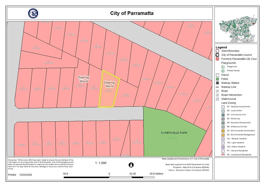
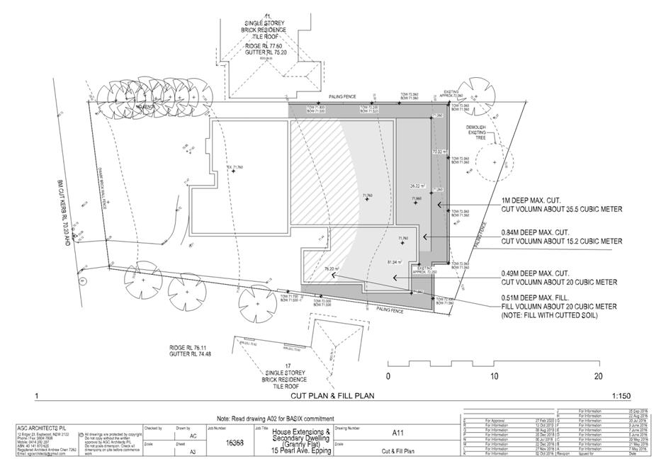
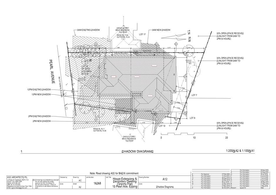
ITEM NUMBER 5.4
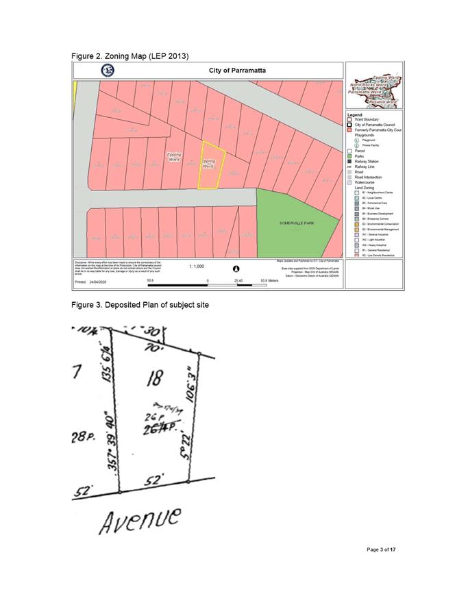
SUBJECT 15 Pearl Avenue, Epping (Lot 18 in DP 18720)
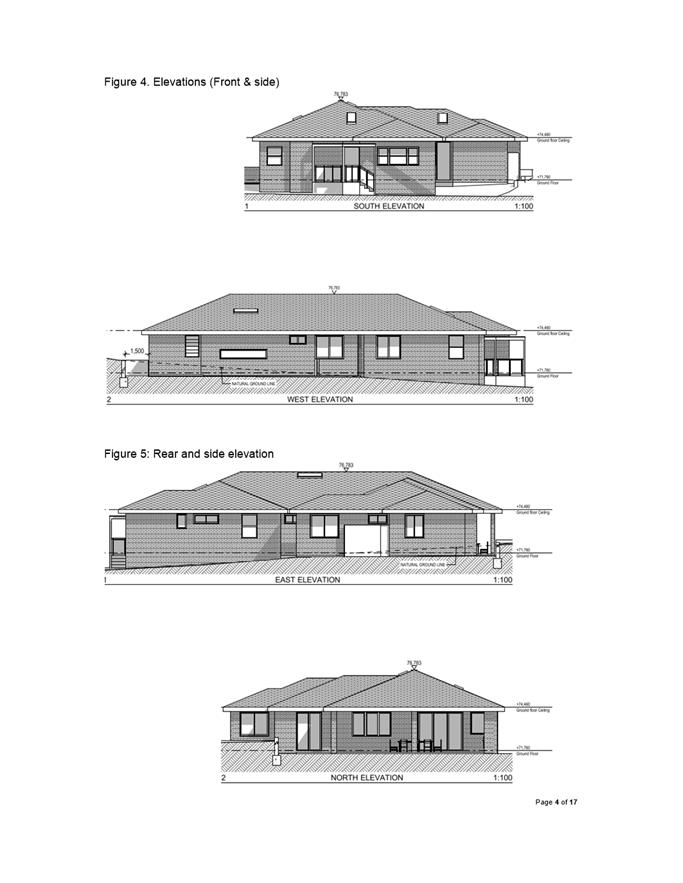
DESCRIPTION Demolition of the existing detached garage, alterations and additions to the existing single-storey dwelling and construction of an attached, two bedroom secondary dwelling.
REFERENCE DA/158/2020 -
APPLICANT/S AGC Architects Pty Ltd
OWNERS Evan Wong, Sao Hoang
REPORT OF Group Manager Development and Traffic Services
|
DATE OF REPORT: 12 May 2020
REASON FOR REFERRAL TO LPP
The subject application is referred to the Parramatta Local Planning Panel as the application has received 23 unique submissions objecting to the development application.
EXECUTIVE SUMMARY
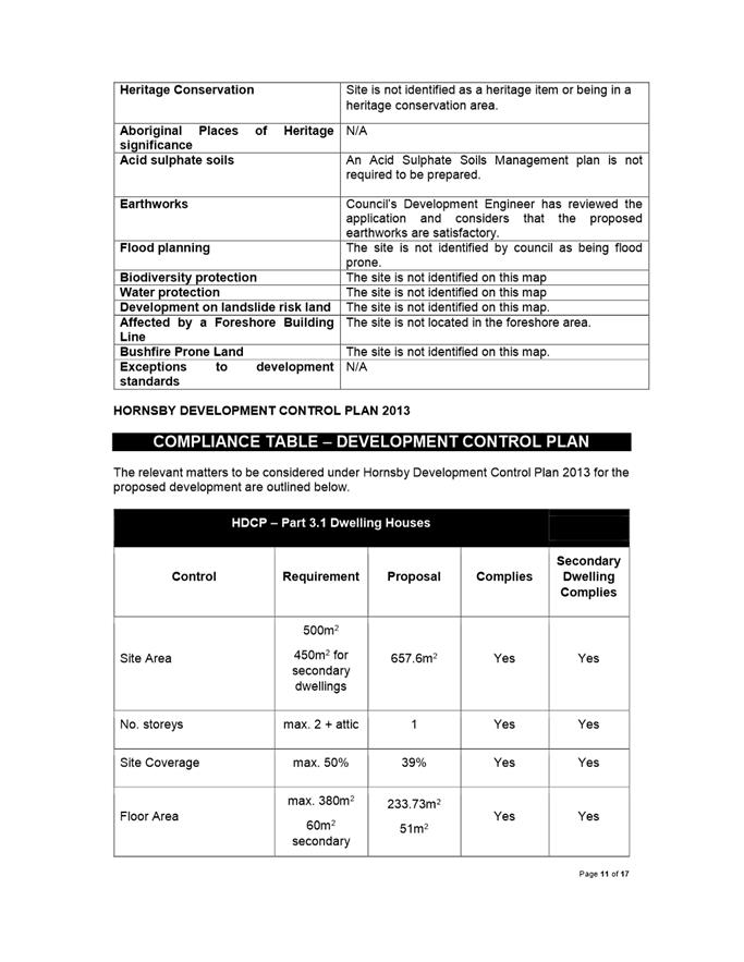
This is a summary of the assessment of the application as outlined in attachment 1, the section 4.15 Assessment Report.
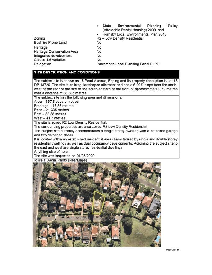
The subject site is known as 15 Pearl Avenue, Epping. The current property description is Lot 18 in DP 18720. The site is zoned R2 Low Density Residential, the proposed development is permissible within the R2 zone.
The site is located within an established low density residential area characterised by single and two storey residential dwellings. The site is currently occupied by a single storey dwelling with a detached garage.
Proposed Development The proposed development includes the following components:
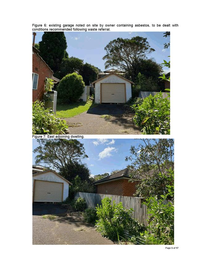
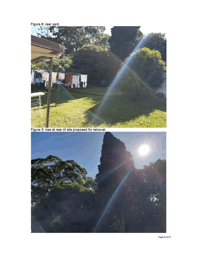
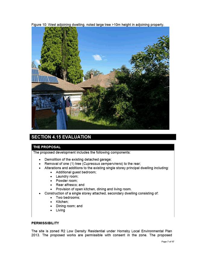
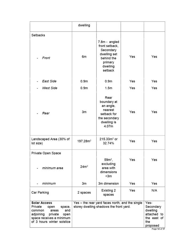
· Demolition of the existing detached garage; · Removal of one tree at the rear of the subject site; · Alterations and additions to the existing single storey dwelling; and · Construction of an attached, two storey secondary dwelling.
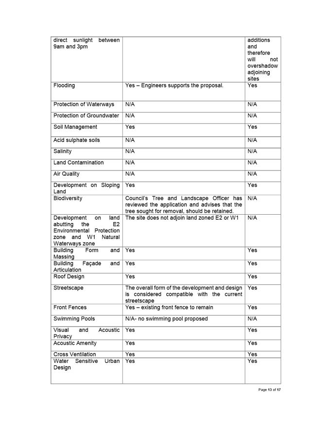
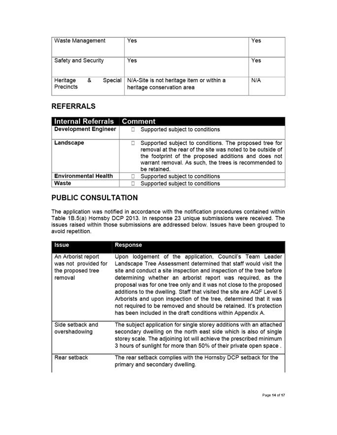
The proposal was referred to Council’s Development Engineer, Landscape and Tree Officer, Environmental Health Officer and Waste Officer. Councils’ Landscape and Tree Officer has raised concern that the tree proposed for removal is of a maturity, height and distance from the building footprint of the additions that the tree is recommended to be retained.
The application was notified in accordance with Council’s notification procedures contained within the Hornsby Development Control Plan 2013. During this time, 23 individual submissions against the application were received. The issues raised in submission include but are not limited to:
· Bulk and Scale · Streetscape impacts · Tree at the rear of the site proposed for removal considered significant to the streetscape · Rear and side setbacks
|
|
Pursuant to Section 4.16(1)(a) of the Environmental Planning and Assessment Act, 1979:
(a) That the Parramatta Local Planning Panel, exercising the functions of Council as a consent Authority approve development consent of DA/158/2020 for demolition of the existing detached garage, alterations and additions to the existing dwellings and construction of a two bedroom secondary dwelling.
(b) Further, that submitters be advised of the Panel’s decision.
|
Michael Stephen
Development Assessment Officer
|
1⇩ |
Attachment 1: Assessment Report |
17 Pages |
|
|
2⇩ |
Attachment 2: Locality Map |
1 Page |
|
|
3⇩ |
Attachment 3: Plans used during assessment |
6 Pages |
|
|
Attachment 4: Internal plans used during assessment (confidential) |
5 Pages |
|
|
|
5⇩ |
Attachment 5: Draft DA Conditions |
22 Pages |
|
REFERENCE MATERIAL
Innovative
16 June 2020
6.1 Pre-Gateway: Planning Proposal for land at 355 and 375 Church St, Parramatta 206
6.2 Pre-Gateway: Planning Proposal for land at 1 Windsor Road, North Rocks 502
6.3 Pre-Gateway: Planning Proposal for land at 114-118 Harris Street, Harris Park 651
Local Planning Panel 16 June 2020 Item 6.1
ITEM NUMBER 6.1
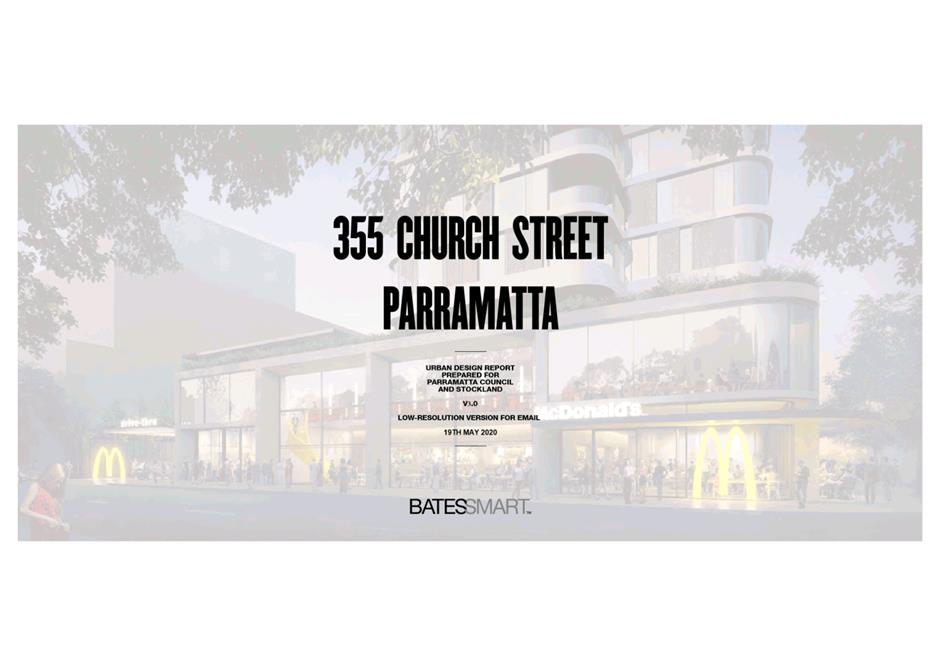
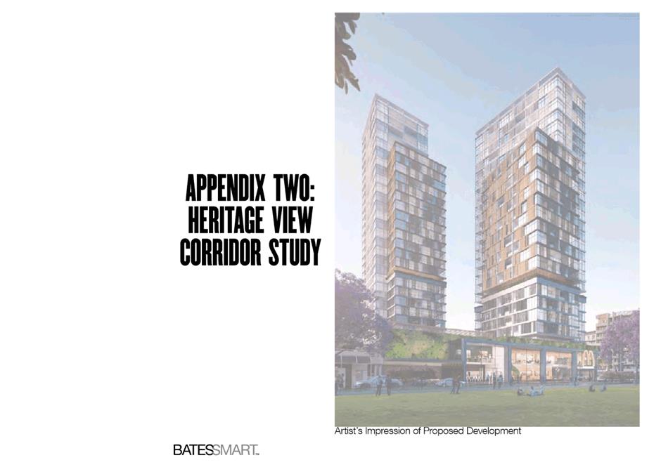
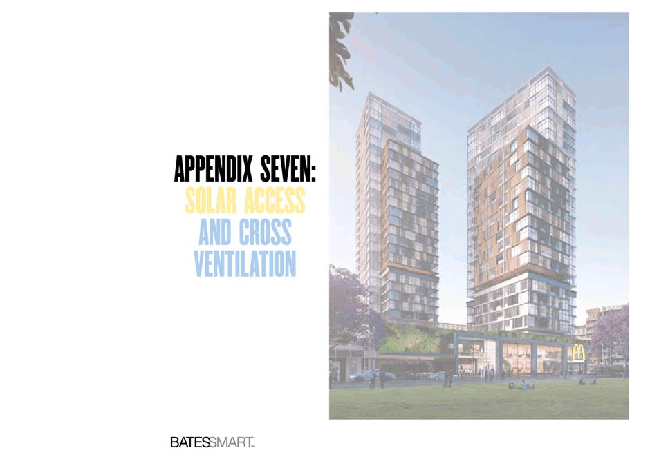
SUBJECT Pre-Gateway: Planning Proposal for land at 355 and 375 Church St, Parramatta
REFERENCE RZ/10/2018 - D07161401
REPORT OF Acting Team Leader Land Use Planning
|
APPLICANT Stockland Development Pty Ltd
LANDOWNER McDonald’s Australia Ltd
PREVIOUS APPLICATIONS
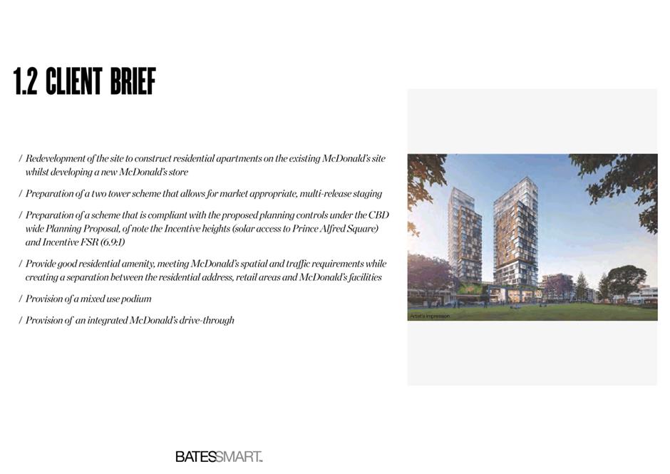
DA/96/2015 – Staged development involving a redeveloped McDonald’s restaurant and concept approval for a future-mixed-use development; the Sydney West Joint Regional Planning Panel deferred its formal determination on this matter, and the application was withdrawn May 2016.
PURPOSE
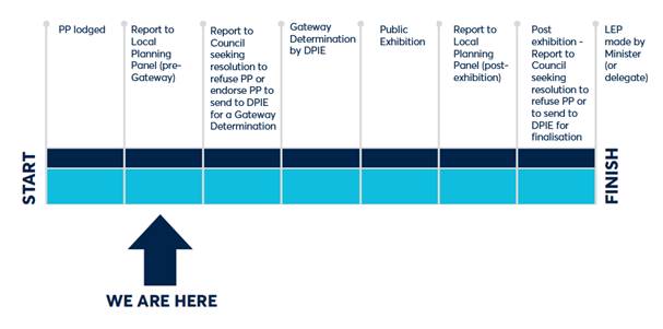
The purpose of this report is to seek the Local Planning Panel’s advice to Council on a Planning Proposal for land at 355 and 375 Church Street, Parramatta. This report recommends forwarding the Planning Proposal to the Department of Planning, Industry and Environment (DPIE) with a request for a Gateway Determination. |
|
That the Local Planning Panel consider the following Council officer recommendation in the Panel’s advice to Council:
(a) That Council endorse for the purpose of forwarding to the Department of Planning, Industry and Environment (DPIE) with a request for a Gateway Determination, the Planning Proposal at Attachment 1 to amend Parramatta LEP 2011 for land at 355 and 375 Church St, Parramatta as follows:
1) Apply the Prince Alfred Square Solar Access Plane as the height controls for this site 2) Increase FSR from part 3:1/part 4:1 to 6:1 (exclusive of Design Excellence) 3) Apply maximum car parking rates as follows: i. For floorspace used for the purposes of Take Away Food and Drink Premises: 1 space / 30 square metres of Gross Floor Area or 30 spaces (whichever is less). Noting that the Planning Proposal also includes a 5-year sunset clause for this parking rate, after which time this rate would revert to the rate contained in the draft Parramatta CBD Planning Proposal. ii. For residential and other commercial floorspace not part of the use described in 3)(i): the rates which are currently contained in the Parramatta CBD Planning Proposal.
(b) That Council advises DPIE that the Chief Executive Officer will not be exercising the plan-making delegations for this Planning Proposal as authorised by Council on 26 November 2012.
(c) That a draft site-specific Development Control Plan (DCP) for the subject site be prepared that addresses matters including but not limited to:
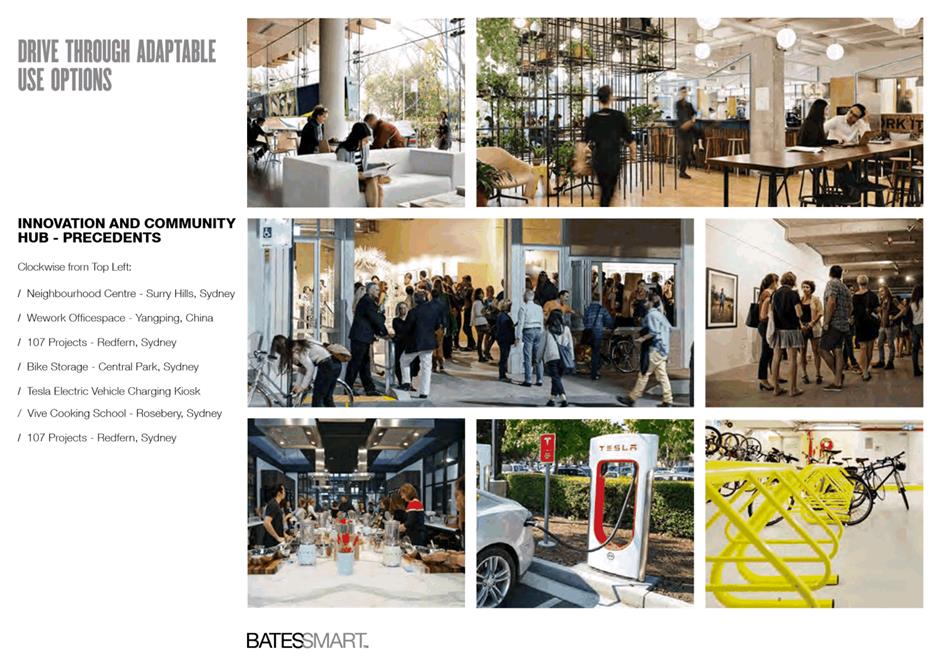
1) Further defining the preferred two-tower scheme, including podium heights and tower setbacks, with a view to minimising any non-compliances with relevant ADG requirements; 2) Relationship to and mitigating impacts on Heritage Items; 3) Traffic issues such as sightlines, vehicle queuing, pedestrian safety and bicycle parking; 4) Demonstrating adaptive re-use potential of drive-through facility and at least some of the parking spaces proposed; 5) Active frontage requirements; and 6) Relationship to 383 Church Street isolated site.
(d) That the CEO be authorised to negotiate a draft Planning Agreement with the landowner in accordance with the Parramatta CBD Community Infrastructure framework.
(e) That the draft DCP and draft Planning Agreement are reported back to Council prior to their concurrent exhibition with the Planning Proposal.
(f) Further, that Council authorise the CEO to amend the Planning Proposal to correct any minor anomalies of a non-policy and administrative nature that may arise during the plan-making process. |
PLANNING PROPOSAL TIMELINE
BACKGROUND
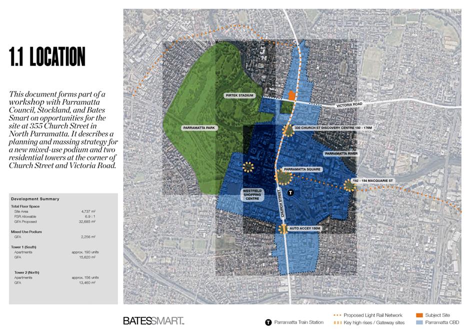
1. On 21 August 2018, Stockland Development Pty Ltd (“the applicant”) lodged a Planning Proposal with Council on behalf of McDonald’s Australia Ltd (“the landowner”) for land at 355 and 375 Church Street, Parramatta (“the site”).
2. The site was the subject of a previous Development Application (DA/96/2015) which proposed a staged development involving a redeveloped McDonald’s restaurant and concept approval for a future mixed-use development. On 11 November 2015, the Sydney West Joint Regional Planning Panel (JRPP) deferred its formal determination of this matter, noting:
“[the Panel] considers the development as now proposed is a lost opportunity to present a major architectural feature on this significant site which is located at the intersection of two historical roadways within Parramatta. The Panel acknowledge the Design Excellence Advisory Panel’s opinion that substantial amendment is required to create a building of more appropriate scale and city character in this very significant location of Parramatta, particularly given Parramatta’s role as Sydney’s western CBD.”
3. This DA was subsequently withdrawn in May 2016. Following withdrawal of the DA, the landowner and applicant prepared a Planning Proposal in response to the evolving strategic planning context for the Parramatta CBD.
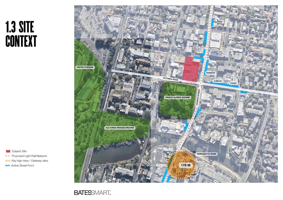
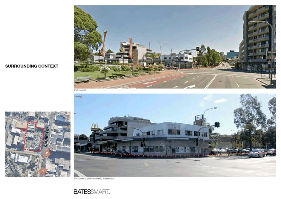
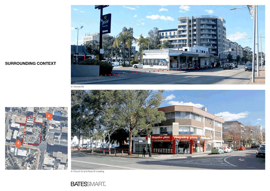
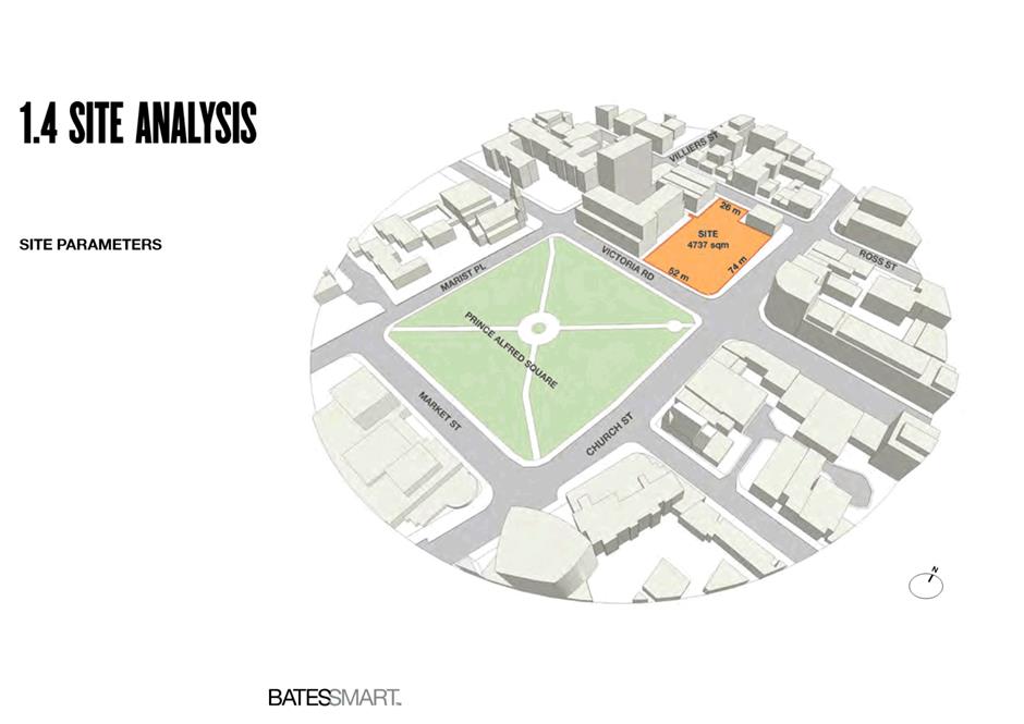
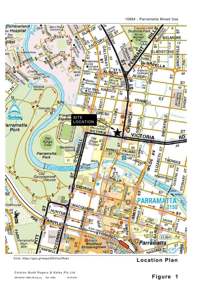
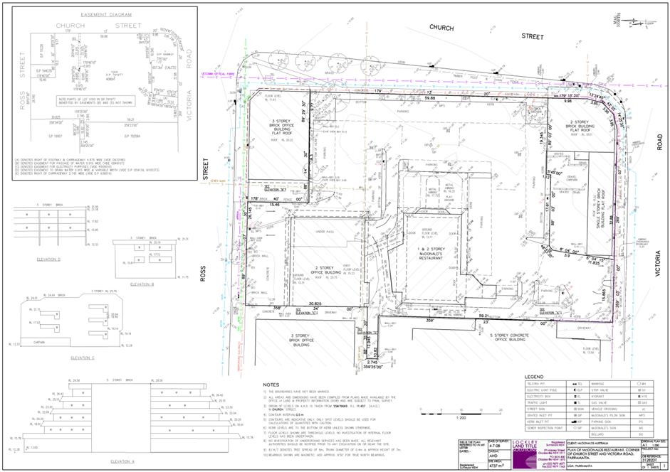
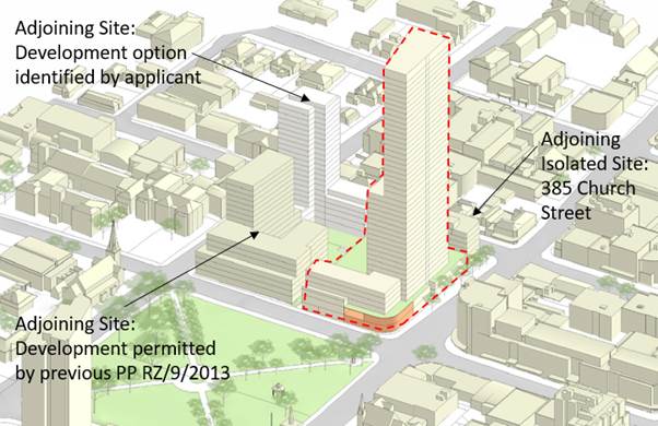
THE SUBJECT SITE AND SURROUNDING CONTEXT
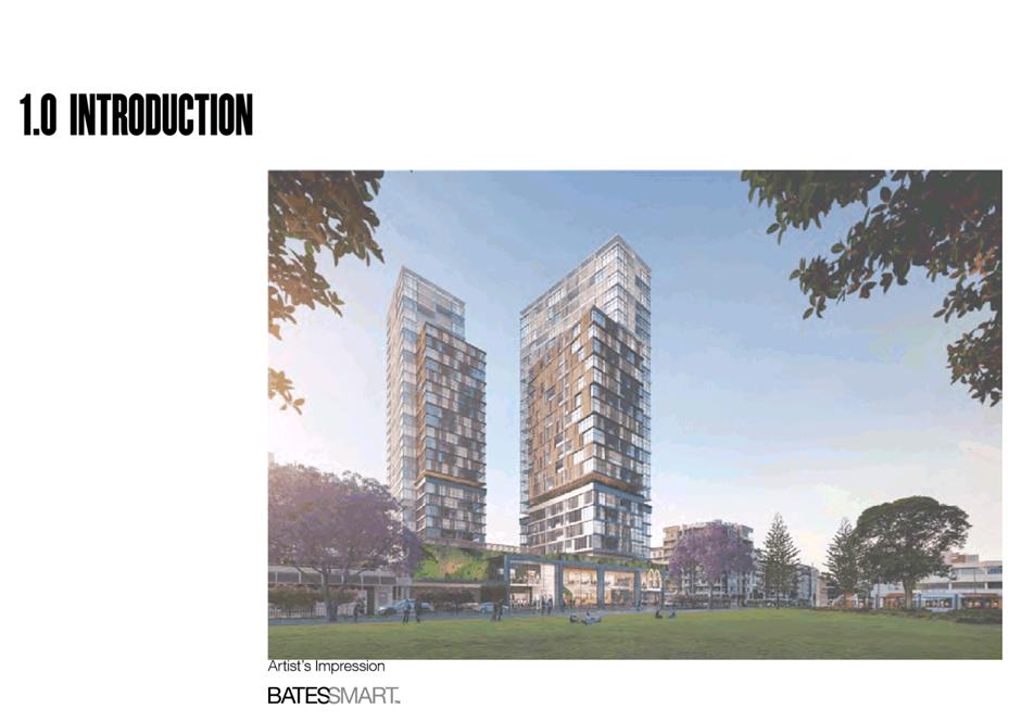
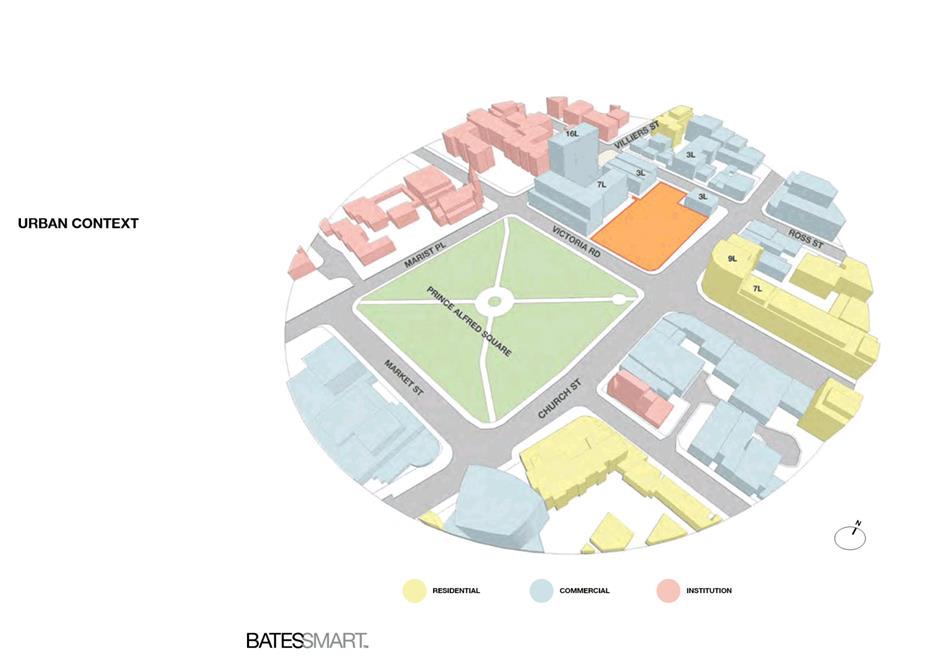
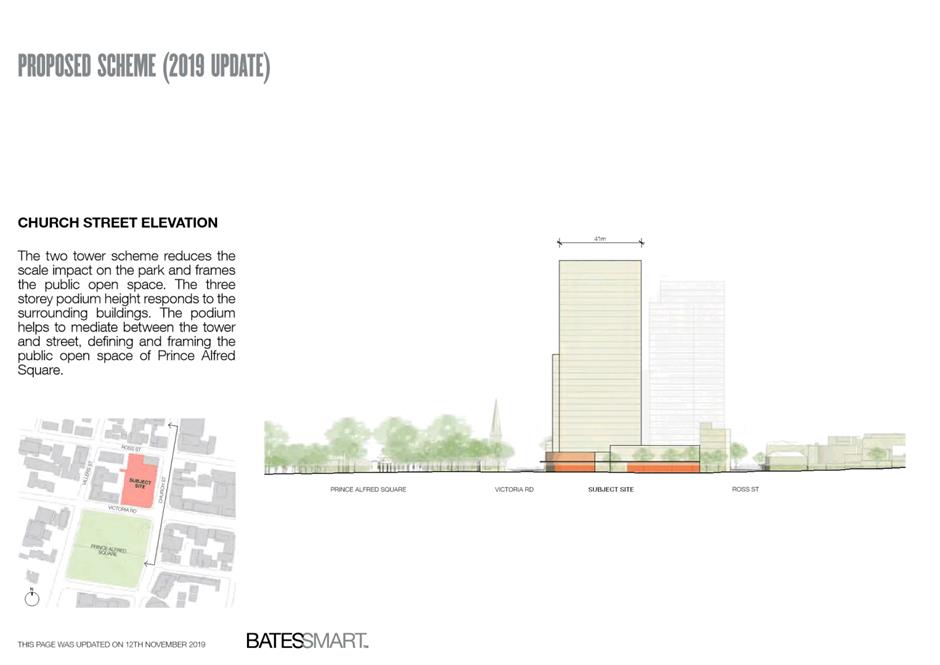
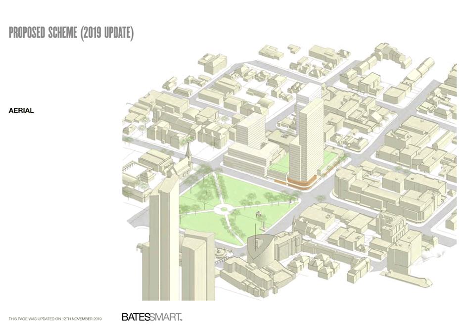
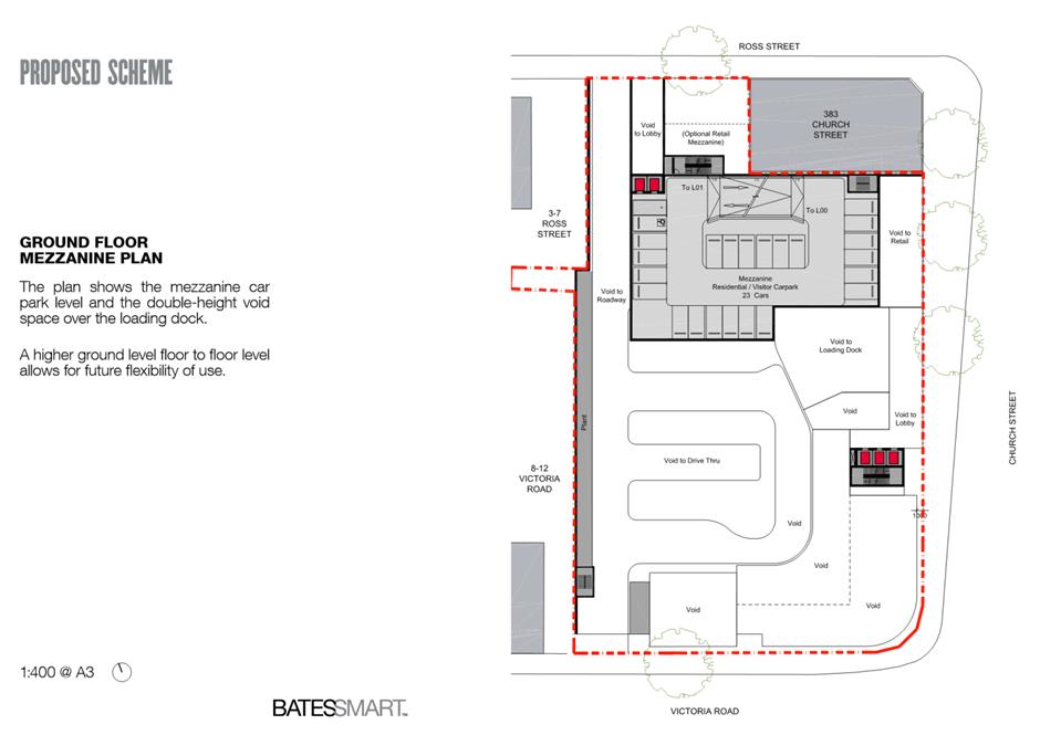
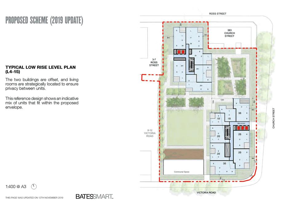
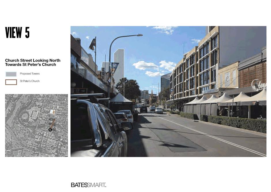
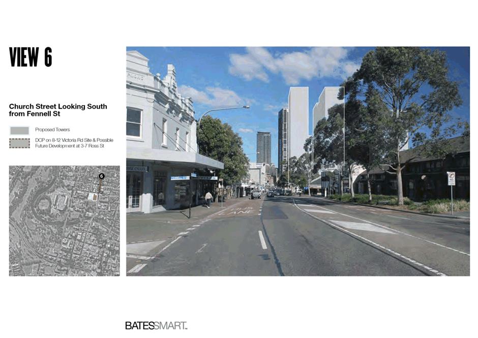
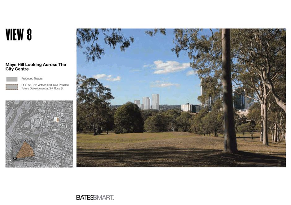
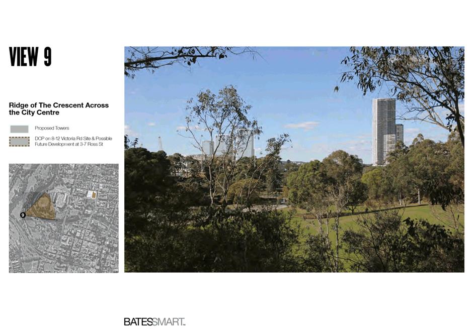
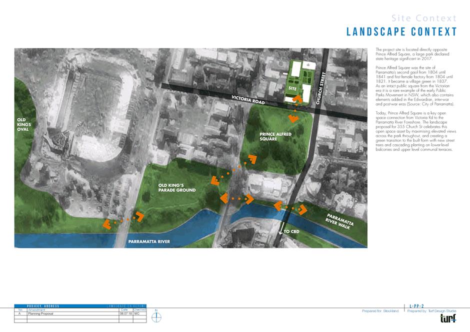
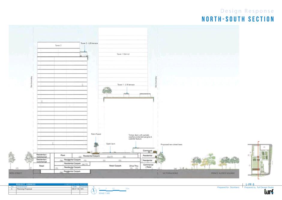
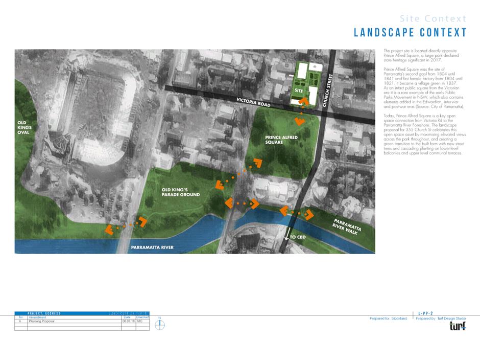
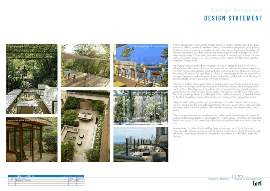
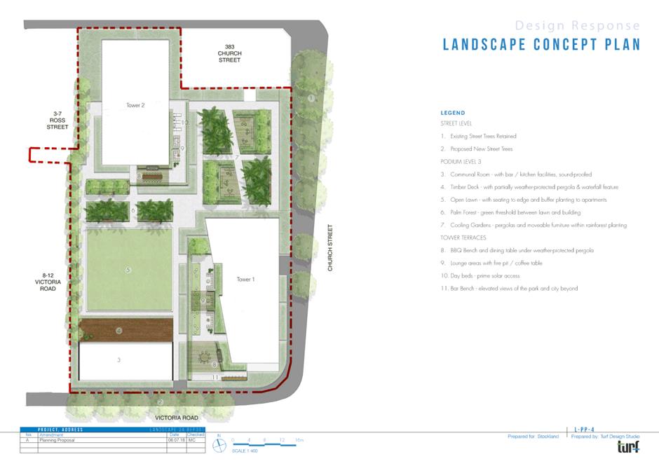
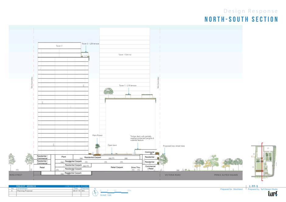
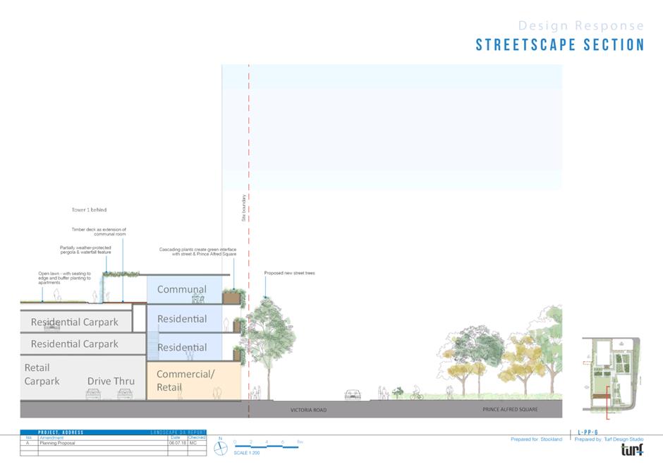
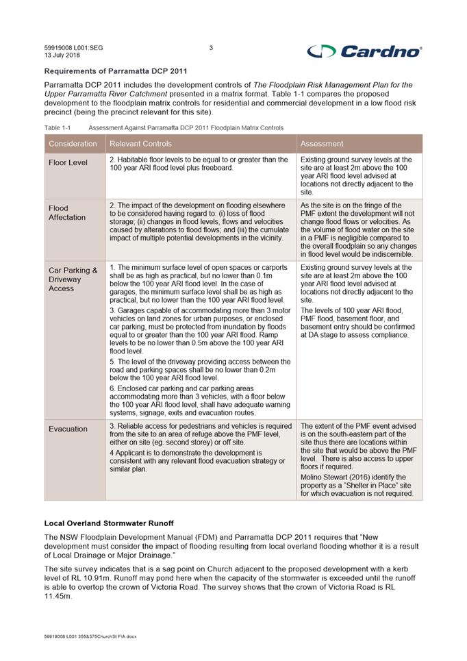
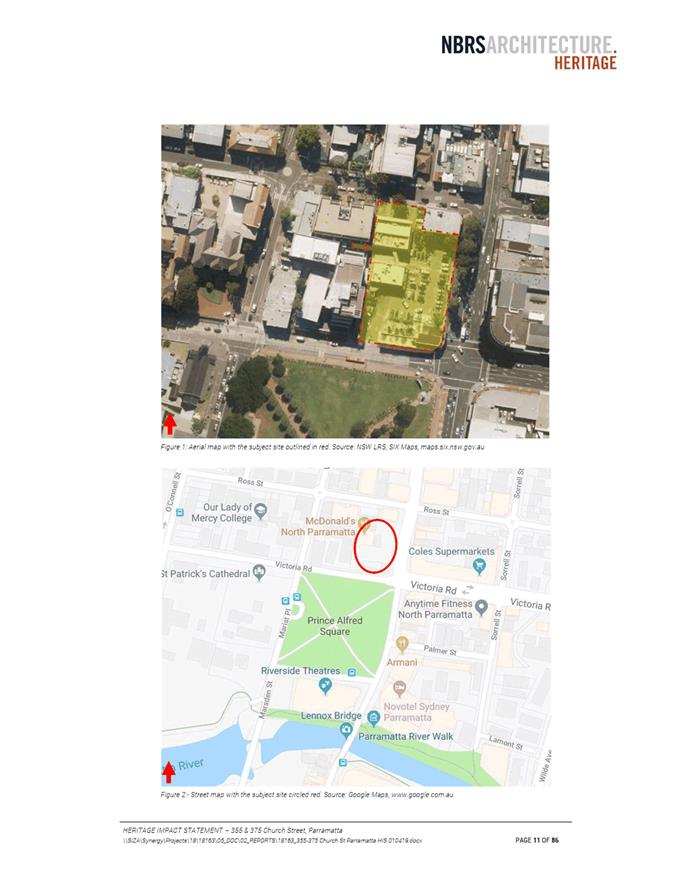
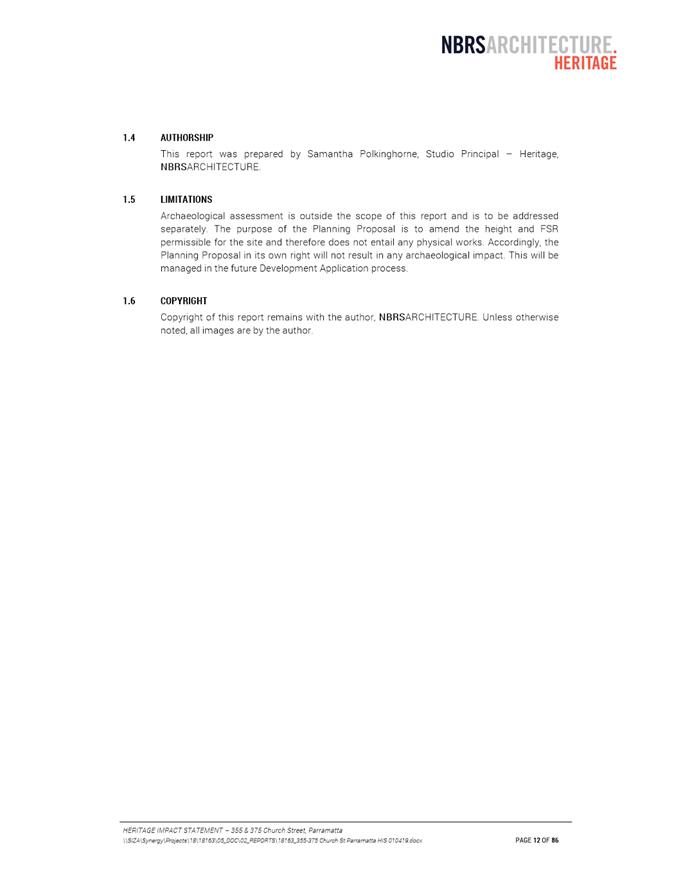
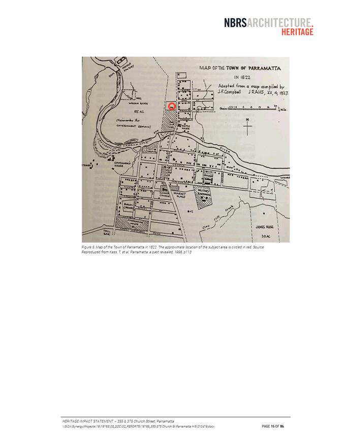
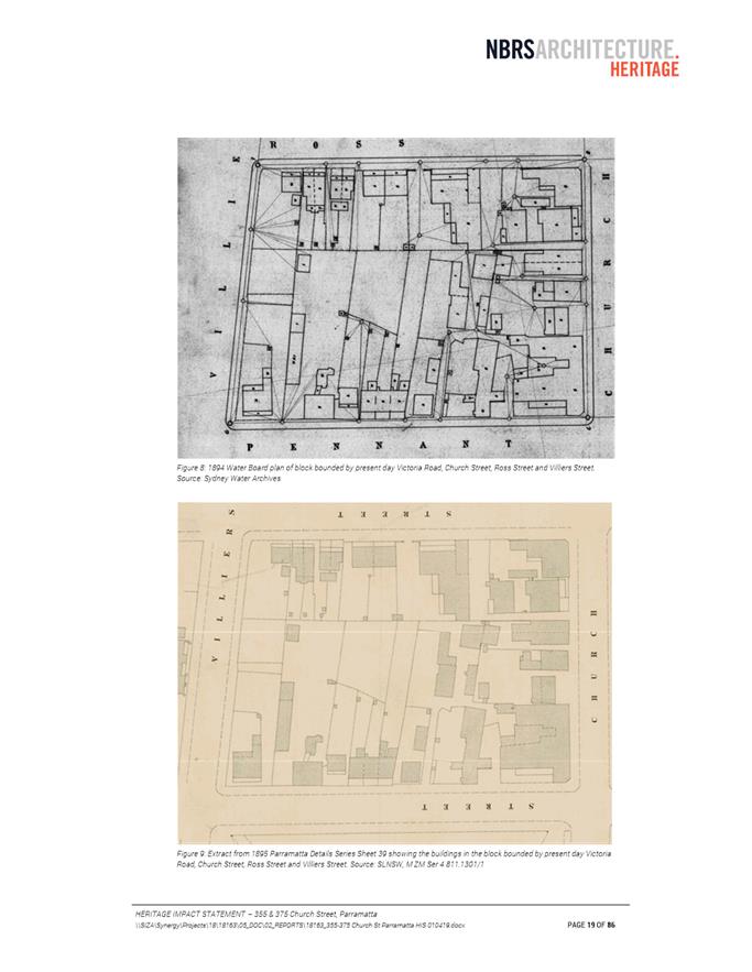
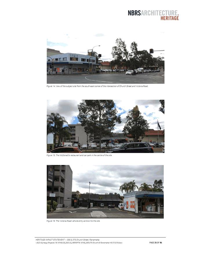
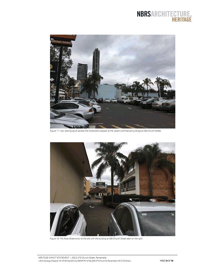
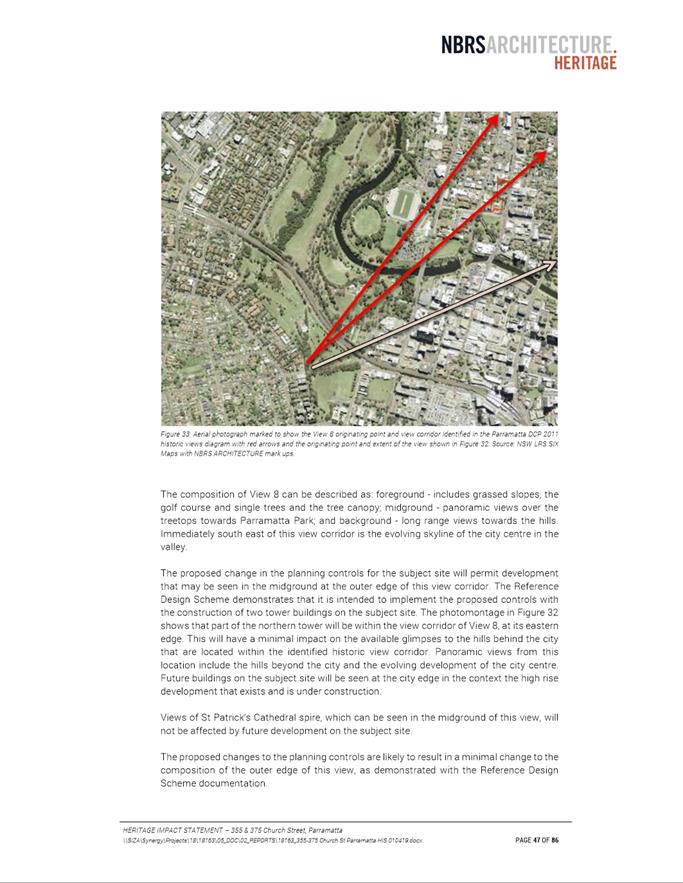
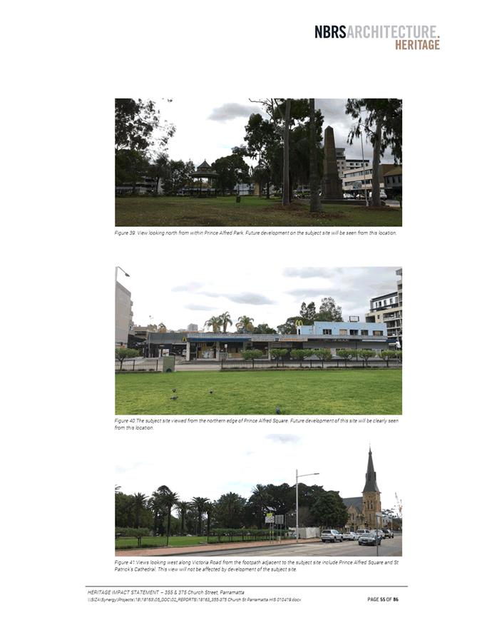
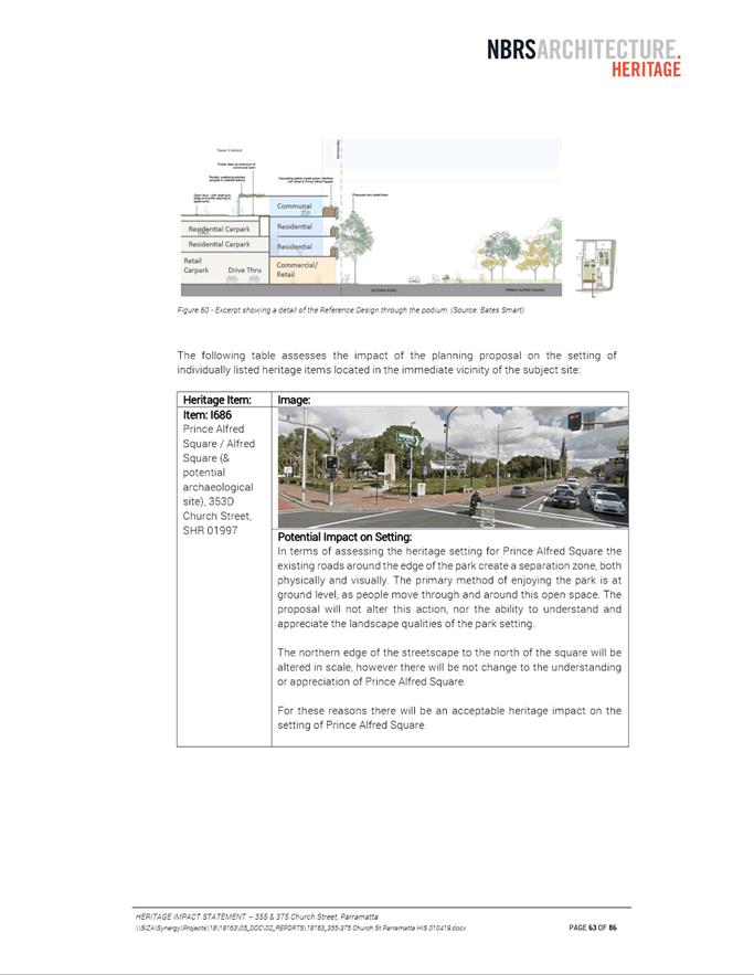
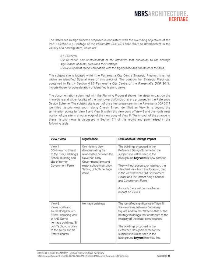
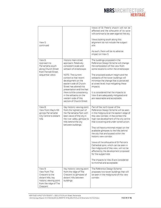
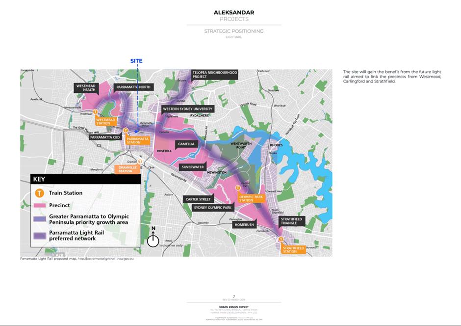
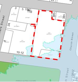
4. The site is illustrated in Figure 1 below. It is located in the block bounded by Victoria Road, Villiers Street, Ross Street and Church Street, Parramatta, and has an approximate site area of 4,796 square metres. The site has frontages to Victoria Road, Church Street and Ross Street. Prince Alfred Square is located South of the site (across Victoria Street), and the Parramatta Light Rail (PLR) Stage 1 corridor runs adjacent to the site along Church Street.
Figure 1: Subject site at 355 and 375 Church Street and surrounding context
Source: Council’s internal mapping with annotations from Council officers
5. Existing development on the site includes a two-storey retail/commercial building (corner of Victoria Road/Church Street), a McDonald’s restaurant (including surface parking and drive-through with vehicle access to both Victoria Road and Ross Street) and a two-storey office building (facing Ross Street).
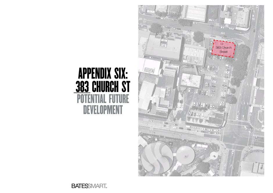
6. The site does not include 383 Church Street, located at the corner of Ross and Church Streets. The existing development at 383 Church Street is a three-storey retail/commercial building. This report addresses the relationship between the subject Planning Proposal and 383 Church Street.
7. The western half of this city block is characterised by low to mid-rise commercial buildings. A previous Planning Proposal (RZ/9/2013) which was finalised in 2016 increased the planning controls over a portion of the western half of the block (illustrated in Figure 1) and involved increasing the FSR control from 2:1 to 4.8:1, and the maximum height control from 24m to 49m. RZ/9/2013 was initiated prior to Council’s strategic work to increase planning controls across the Parramatta CBD through the Parramatta CBD Planning Proposal process, and therefore did not respond to the Parramatta CBD Planning Proposal.
COMPARISON OF PLANNING CONTROLS: EXISTING, PARRAMATTA CBD PLANNING PROPOSAL AND SITE-SPECIFIC PLANNING PROPOSAL
8. Table 1 outlines the planning controls for the site under three scenarios: (1) existing, (2) Parramatta CBD Planning Proposal and (3) recommended by Council officers for this site-specific Planning Proposal.
Table 1: Comparison of planning controls
|
|
Parramatta LEP 2011 |
Parramatta CBD Planning Proposal endorsed by Council 25 November 2019 |
Planning Proposal recommended in this report |
|
Zoning |
B4 Mixed Use |
B4 Mixed Use |
B4 Mixed Use |
|
Max. height of building |
Part 34m, part 24m |
Prince Alfred Square Sun Access Plane
(approx. 29 stories maximum within the portion of the site affected by the Sun Access Plane and no height limit on portion of site outside the Sun Access Plane) |
Prince Alfred Square Sun Access Plane
(in the preferred reference design, this results in approx. 29 storeys within the portion of the site affected by the Sun Access Plane and approx. 32 storeys on the portion of the site outside the Sun Access Plane) |
|
Maximum FSR |
Part 3:1, part 4:1 |
6:1 (plus Design Excellence i.e. 6.9:1) |
6:1 (plus Design Excellence i.e. 6.9:1) |
|
Site-specific provisions |
Nil |
Maximum car parking rates: Residential: Studio: 0.1 spaces 1 bed: 0.3 spaces 2 bed: 0.7 spaces 3 bed: 1 space
Commercial premises: M = (G X A) / (50 X T) Where: M is the maximum number of parking spaces, G is the gross floor area of all commercial uses in the building in square metres, A is the site area in square metres, and T is the total gross floor area of all buildings on the site in square metres
Commercial - Take away food and drink premises: no rate provided.
|
Maximum car parking rates: Residential: Studio: 0.1 spaces 1 bed: 0.3 spaces 2 bed: 0.7 spaces 3 bed: 1 space
Commercial premises (excluding Take Away Food and Drink Premises): M = (G X A) / (50 X T) Where: M is the maximum number of parking spaces, G is the gross floor area of all commercial uses (excluding Take Away Food and Drink Premises) in the building in square metres, A is the site area in square metres, and T is the total gross floor area of all buildings on the site in square metres
Commercial - Take Away Food and Drink Premises: 1 space / 30 sqm GFA or 30 spaces, whichever is less; include a 5-year sunset clause for this provision |
|
Maximum gross floor area (GFA) |
15,047m2 |
33,092m2
|
33,092m2
|
|
Maximum dwelling yield
|
Approximately 177 units (maximum GFA / 85 m2 for high density dwellings) |
Approximately 389 residential units (assuming average GFA / 85 m2 for high density dwellings and all FSR built as residential) |
Approximately 346 residential units and approximately 1,355m2 for Commercial Uses and Take Away Food and Drink Premises (as per current reference design) |
9. Under the current provisions of the Parramatta CBD Planning Proposal, the development proposed in the reference design would be eligible for the High-Performing Building Bonus. However, it is noted that the Applicant has not requested application of this bonus through this site-specific Planning Proposal process and given this the ability of this site to achieve the bonus within the solar access plane has not been tested. The Applicant could potentially seek this bonus at DA stage, depending on the timing of that DA assessment process and the Parramatta CBD Planning Proposal process.
10. Procedurally, it is recommended that the height and FSR controls outlined above are contained in a site-specific clause, rather than as mapped amendments. This is because current Parramatta LEP 2011 maps do not contain the Prince Alfred Square Sun Access Plane (this is to be introduced under the Parramatta CBD Planning Proposal). It is noted that further guidance regarding structural clause drafting will be provided by DPIE and Parliamentary Counsel later in the process if required.
11. In summary, this Planning Proposal is consistent with the Parramatta CBD Planning Proposal, with the exception of specifying a parking rate for the Take Away Food and Drink Premises use proposed as part of the reference design. This issue is discussed in further detail later in this report.
ASSESSMENT OF KEY PLANNING ISSUES
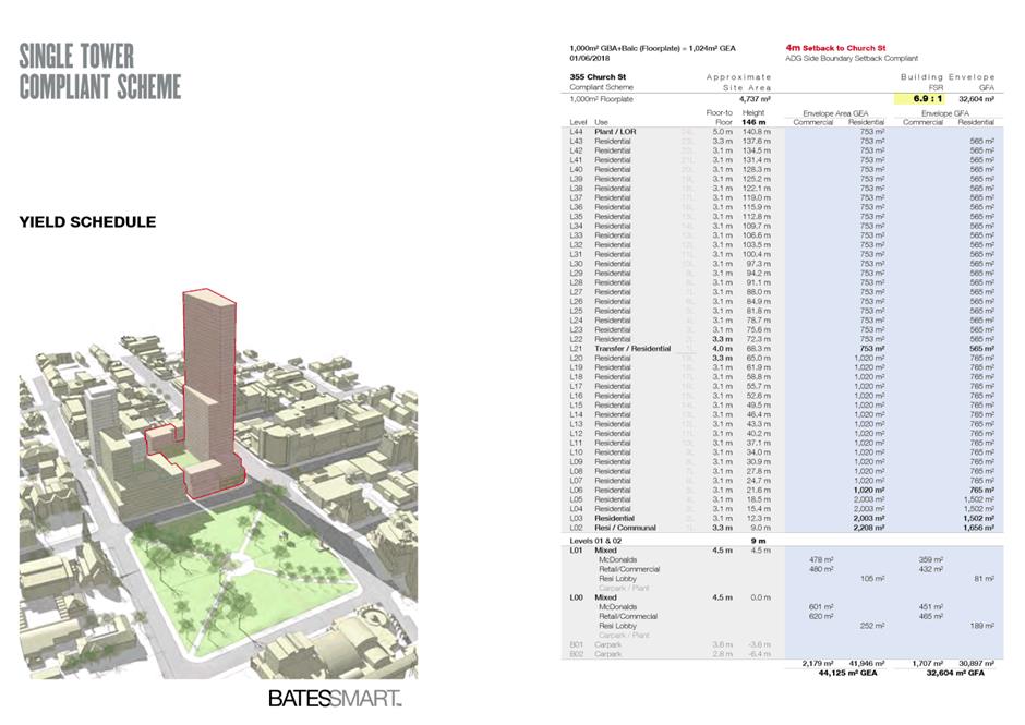
Floor Space Ratio (FSR)
12. The FSR sought under this Planning Proposal (6:1 FSR + 15% Design Excellence bonus, bringing the total FSR to 6.9:1) is consistent with the provisions for this site under the Parramatta CBD Planning Proposal. This aspect of the Planning Proposal is therefore supported by Council officers.
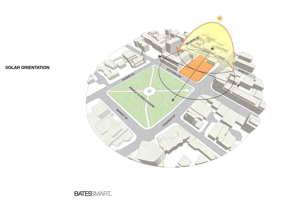
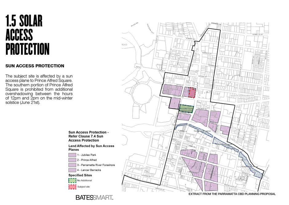
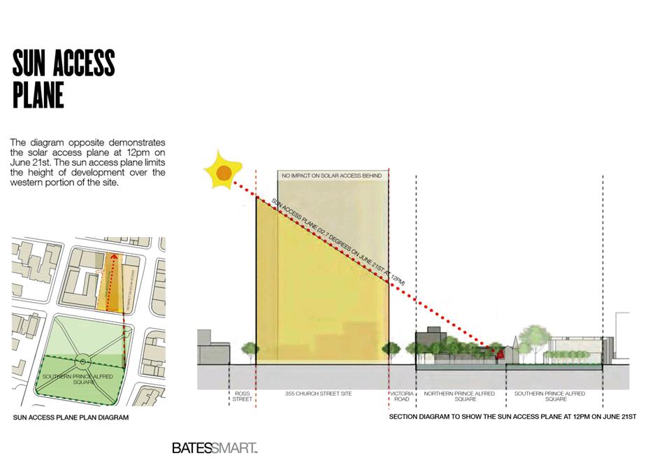
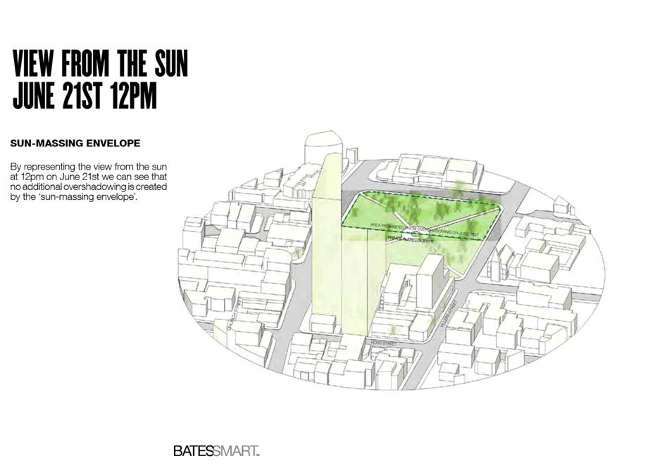
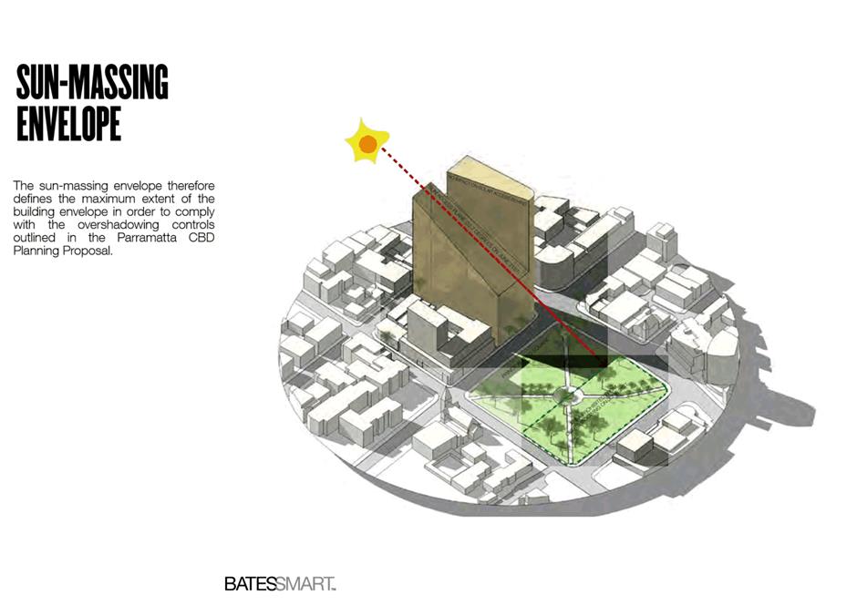
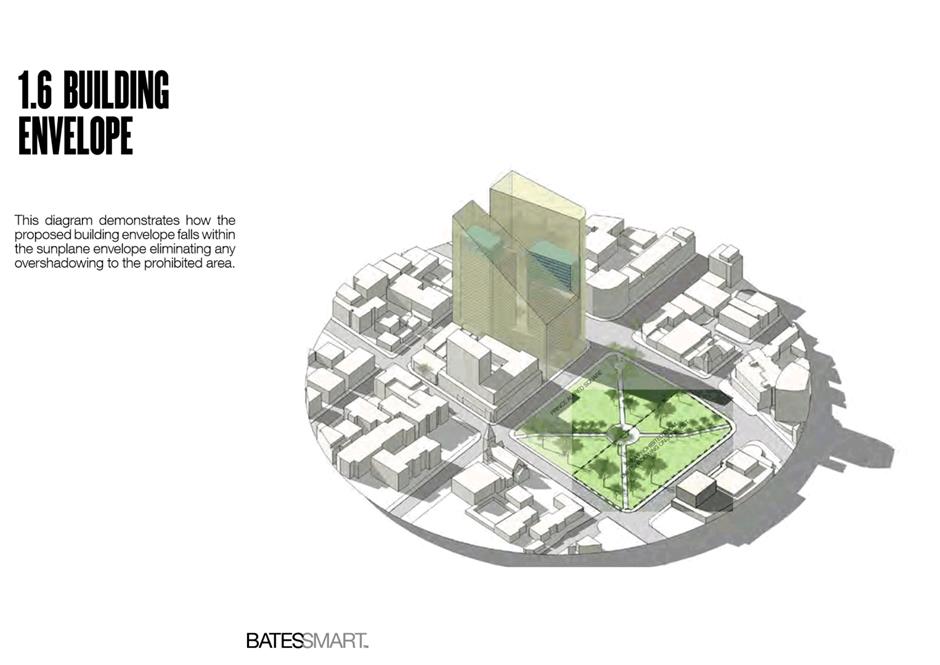
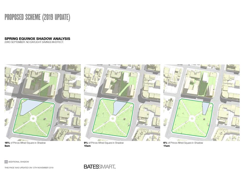
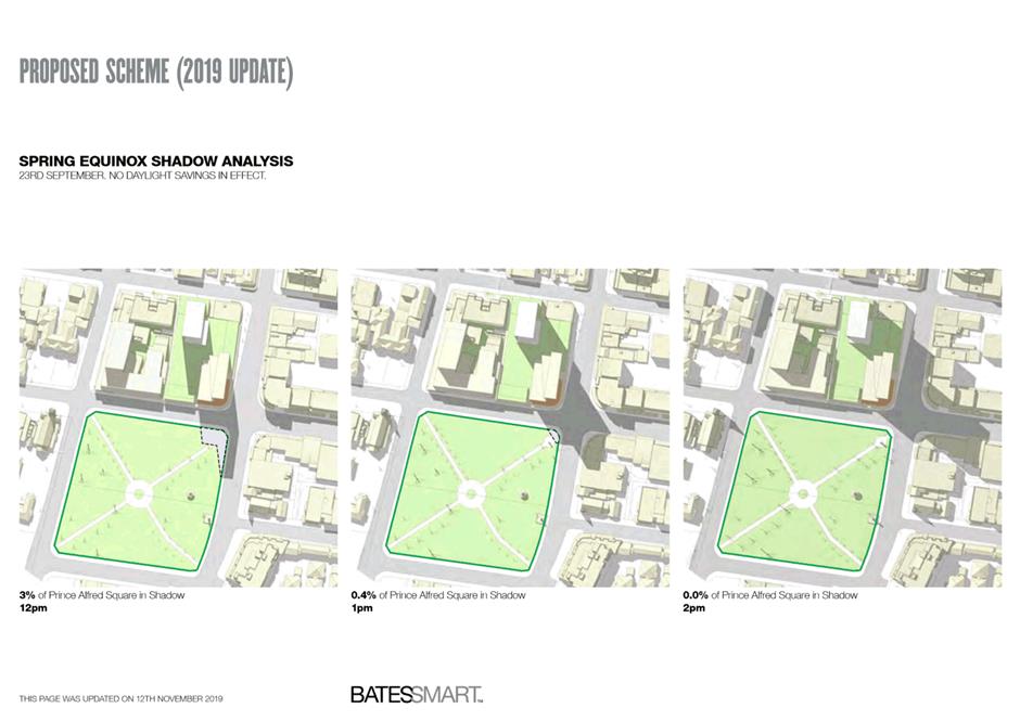
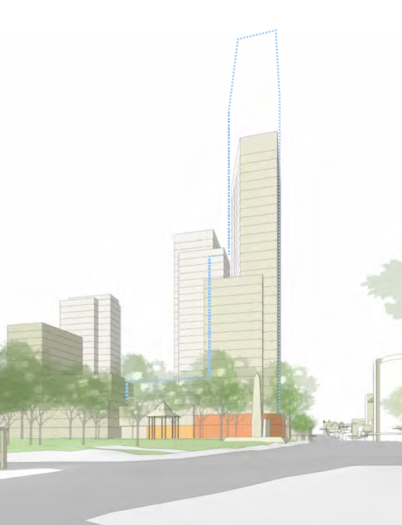
Height and Sun Access Plane (SAP) to Prince Alfred Square
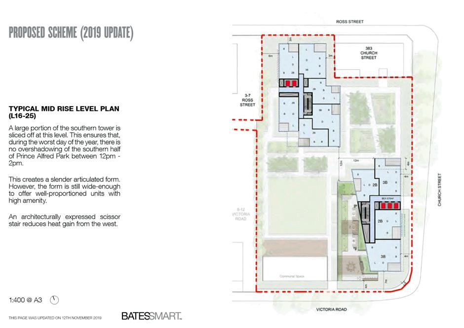
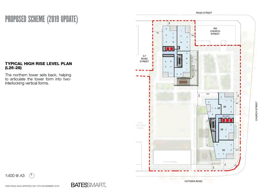
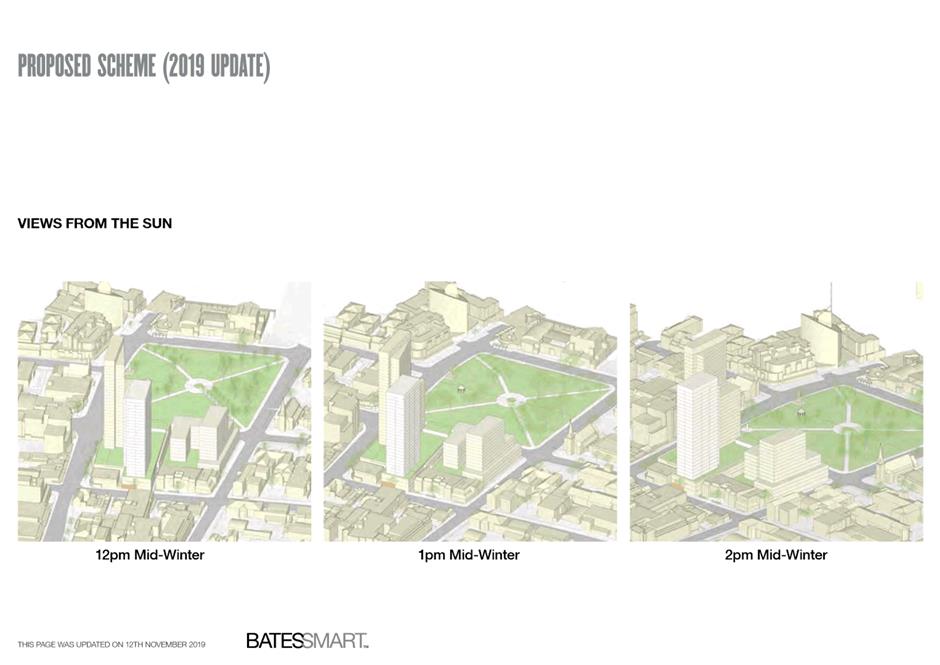
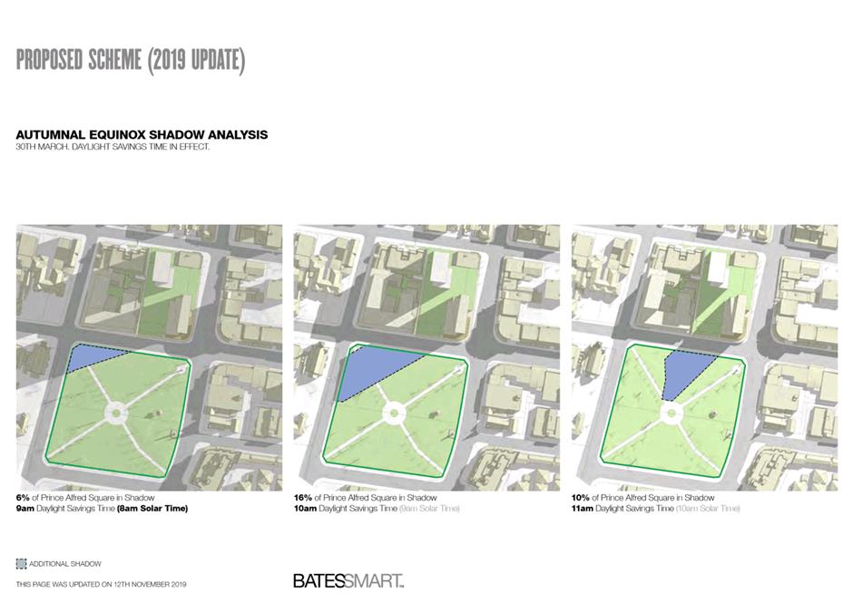
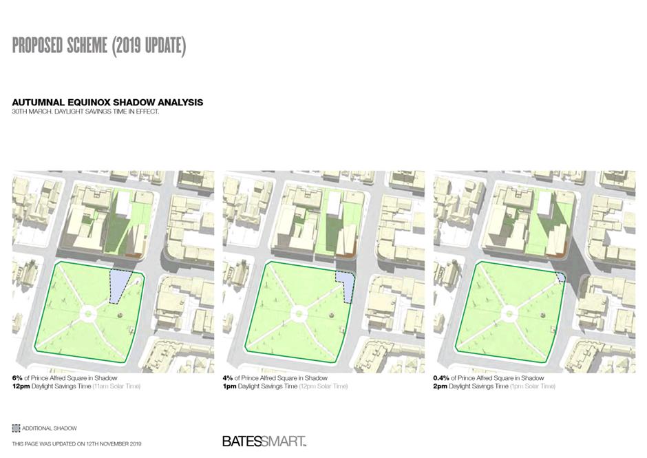
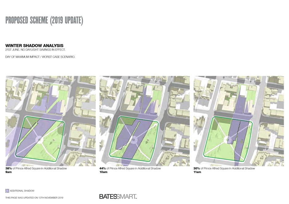
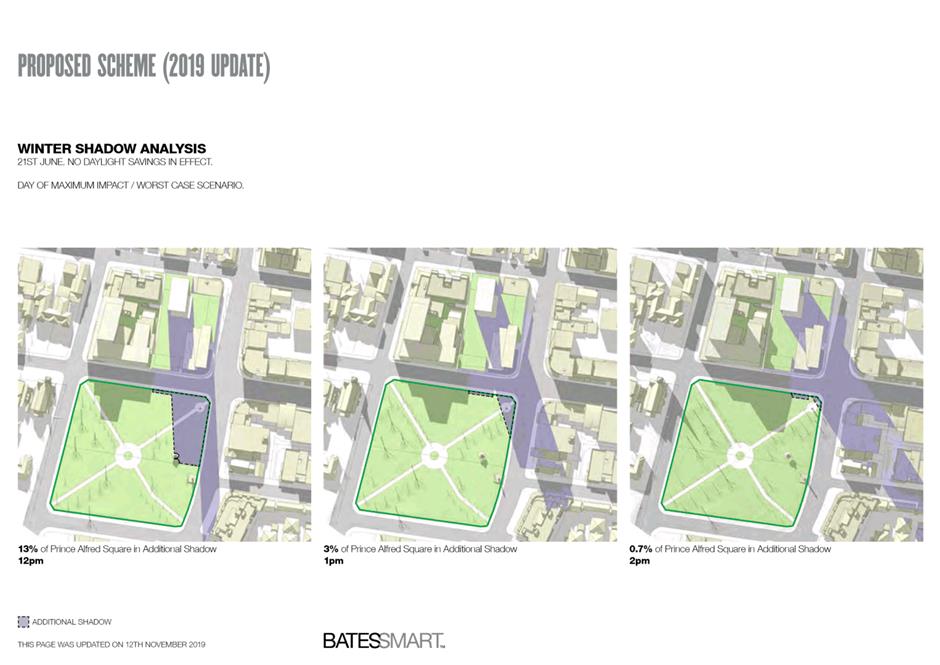
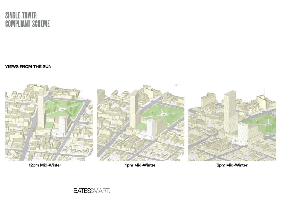
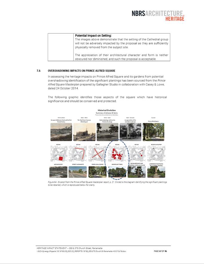
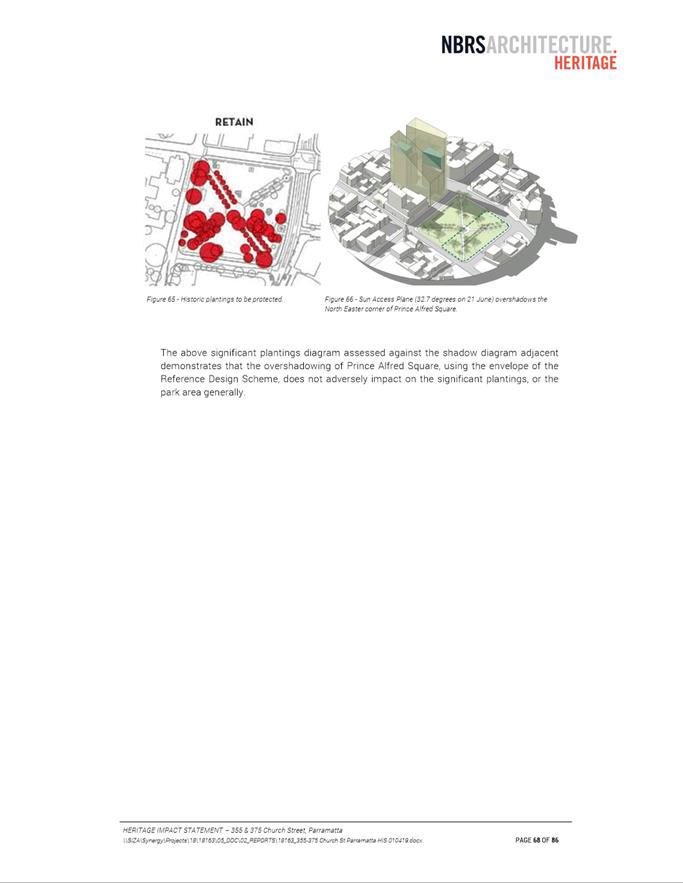
13. Under the Parramatta CBD Planning Proposal, the height controls for this site are determined by the Prince Alfred Square Sun Access Plane (SAP). The SAP ensures that no additional overshadowing is created on the southern part of the Square between 12pm-2pm in midwinter (21 June). Figures 2 and 3 illustrate the protected portion of the park, and the impact that this control has on the potential building envelope for this site.
Figure 2: Portion of Prince Alfred Square protected by SAP (blue hatching)
Source: Draft Parramatta CBD Planning Proposal (as at time of report writing)
Figure 3: Prince Alfred Square SAP and resulting building envelope on subject site
Source: Applicant’s reference design
14. The Planning Proposal aligns with the desired outcomes of the Parramatta CBD Planning Proposal on this issue, as it seeks to replicate the Prince Alfred Square SAP in its provisions and presents a preferred scheme that is compliant with this SAP (as discussed in the following section). Therefore, Council officers support the changes to height controls sought under this Planning Proposal.
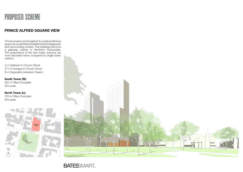
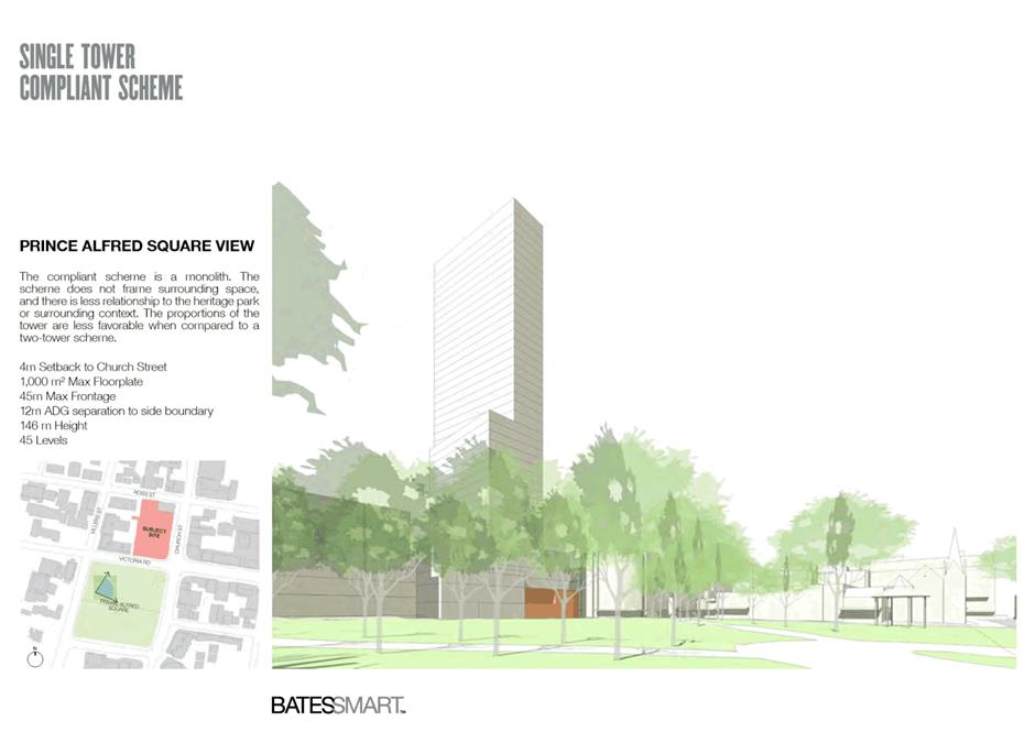
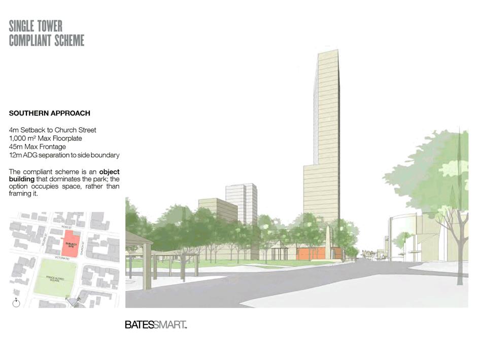
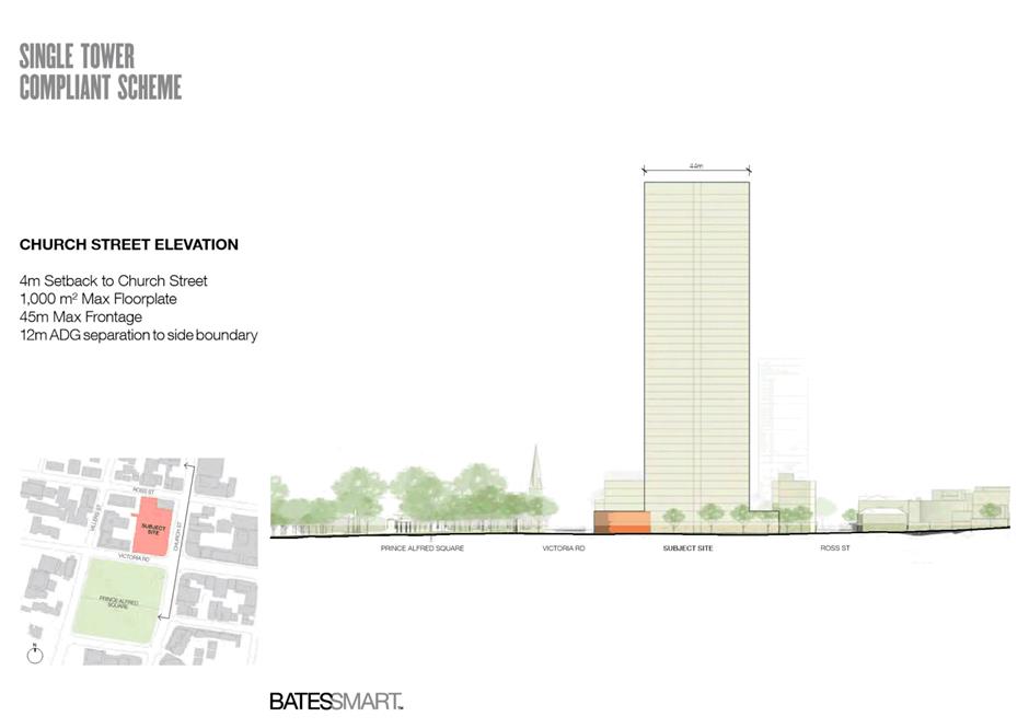
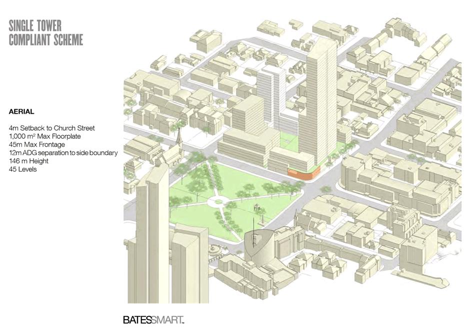
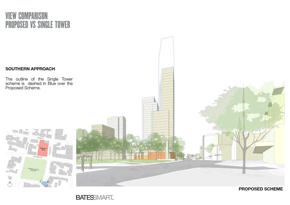
Reference Design and Tower Massing
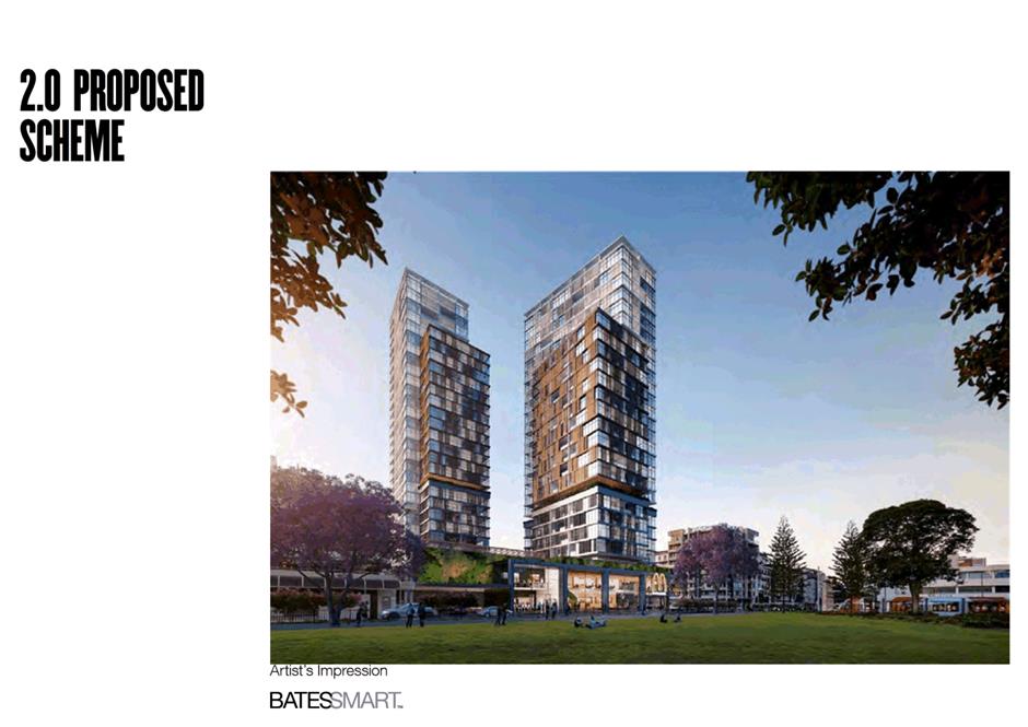
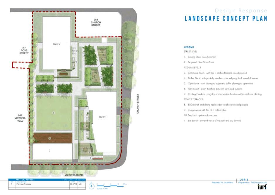
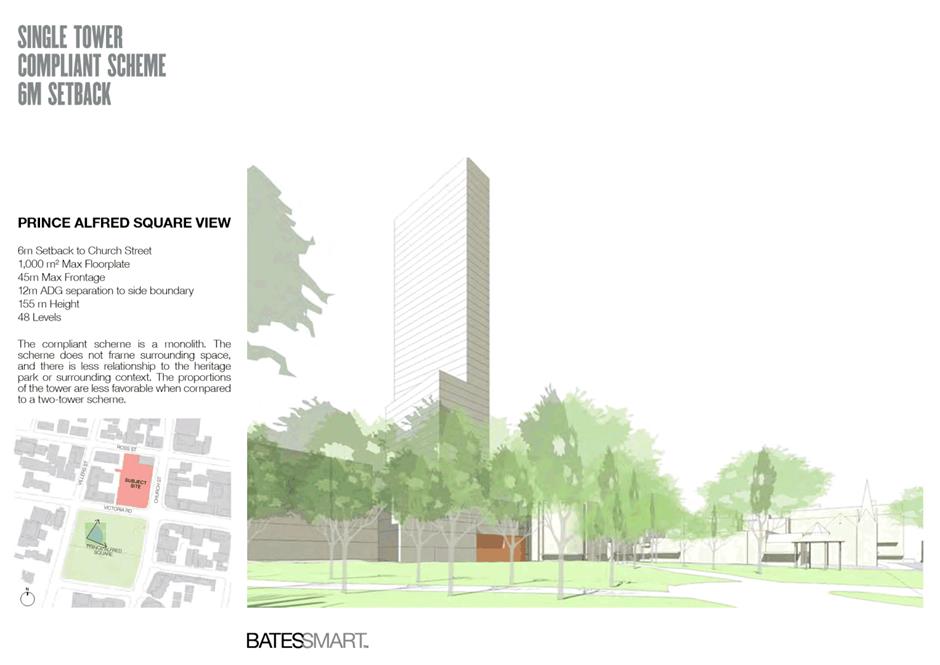
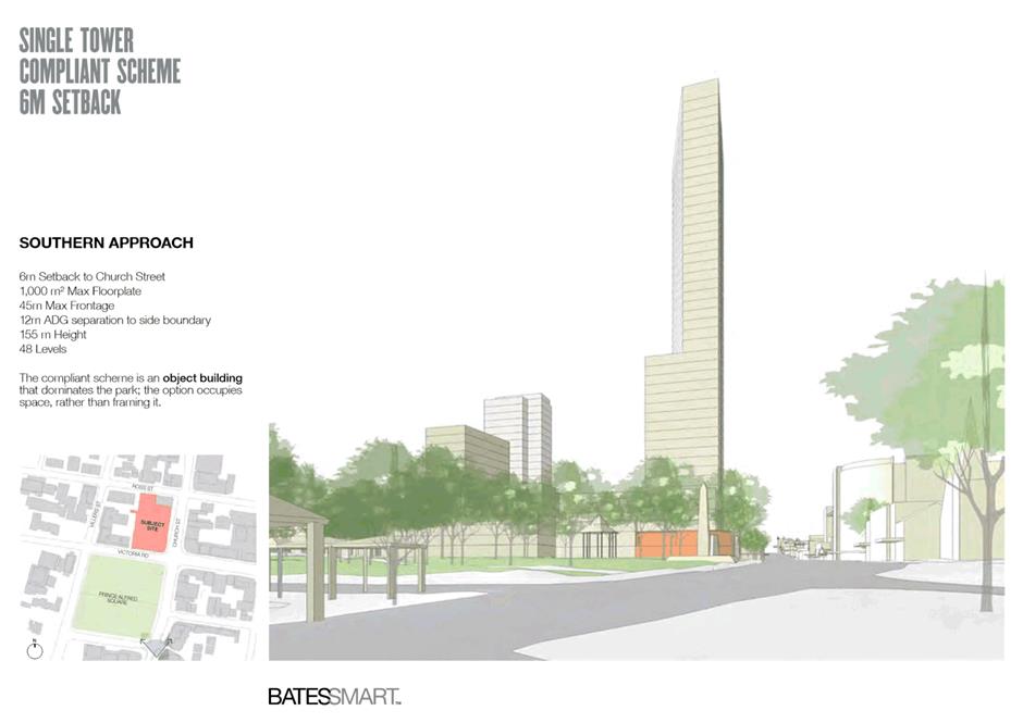
15. The applicant prefers a two-tower scheme on the site due to the market advantages of a staged development. However, the development of a two-tower reference design for this site indicated that there would likely be some non-compliances with setback and building separation requirements. To address this issue, the applicant explored one-tower and two-tower reference design schemes in the urban design analysis submitted as part of the Planning Proposal (refer to Attachment 2). Example images of these two schemes are shown below in Figures 4 and 5. Both schemes are compliant with the Prince Alfred Square SAP, as discussed in the previous section.
Figure 4: Example view - Two-tower reference design scheme –outlined in red
Source: Applicant’s reference design with annotations by Council officers
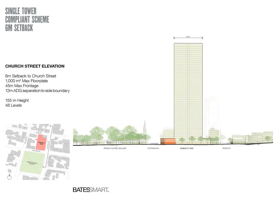
Figure 5: Example view - one-tower reference design scheme (outlined in red)
Source: Applicant’s reference design with annotations by Council officers
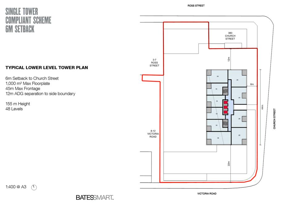
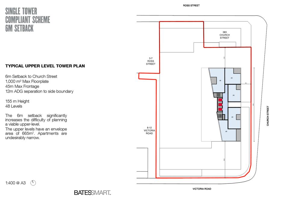
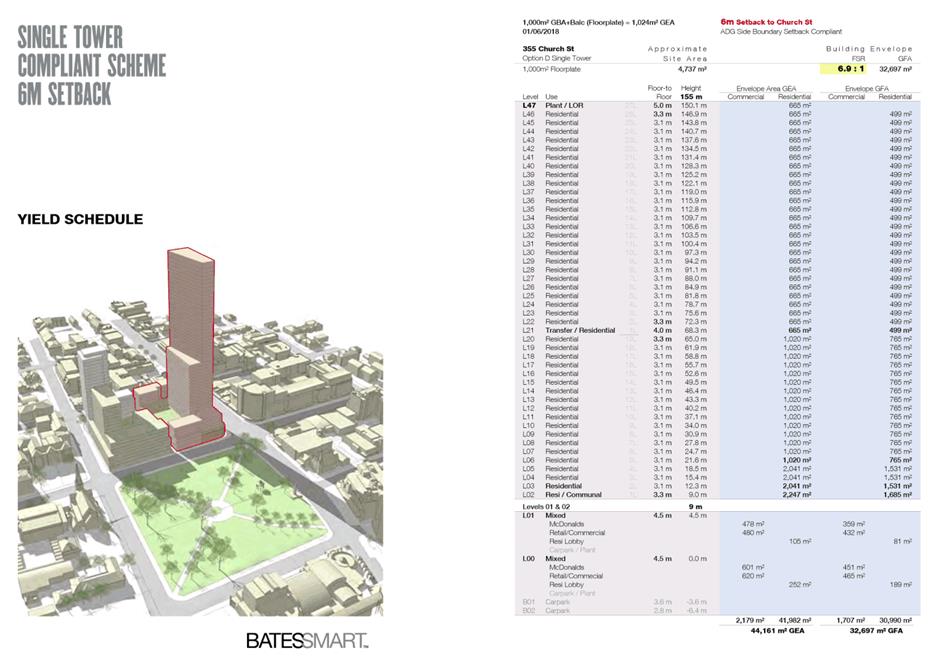
16. The one-tower scheme (shown in Figure 5) has a 7-8 storey podium and a single tall tower of 48 storeys fronting Church Street. The Prince Alfred Square SAP is the main driver behind the form of this scheme. The SAP impacts development massing on this site by push the massing “down” into a higher podium and “out” to the eastern part of the site to become concentrated into a single tall tower located on the Church St frontage.
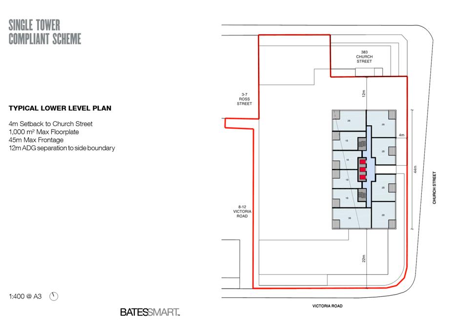
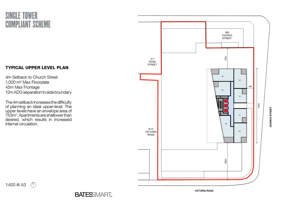
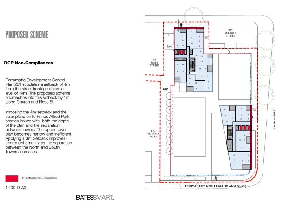
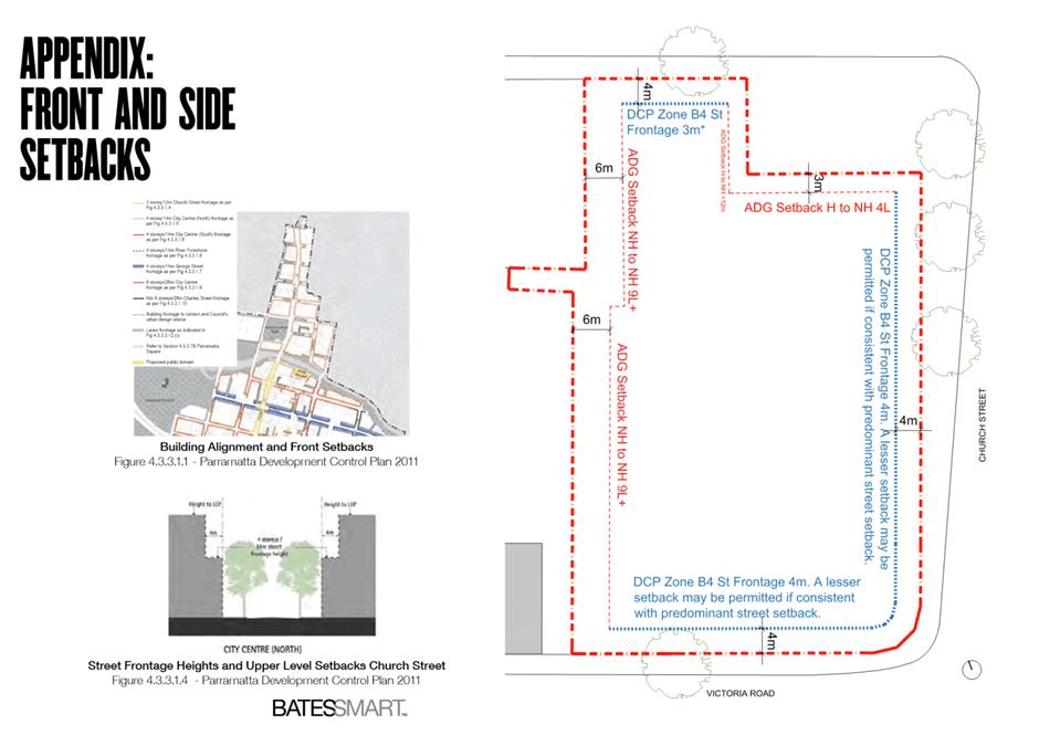
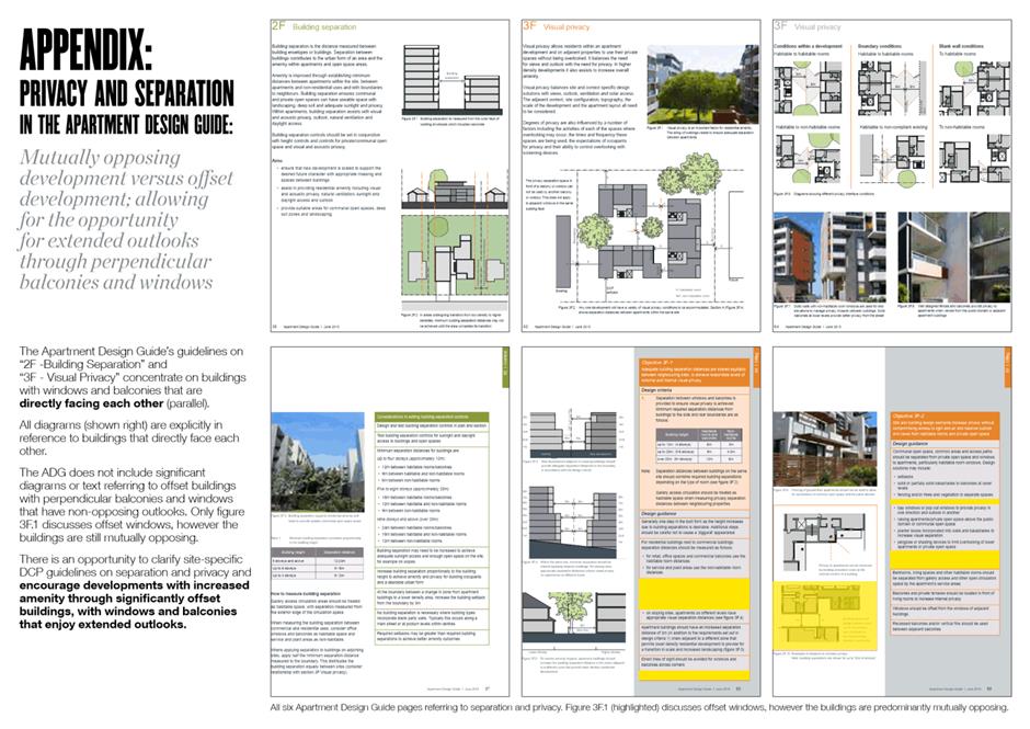
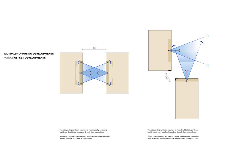
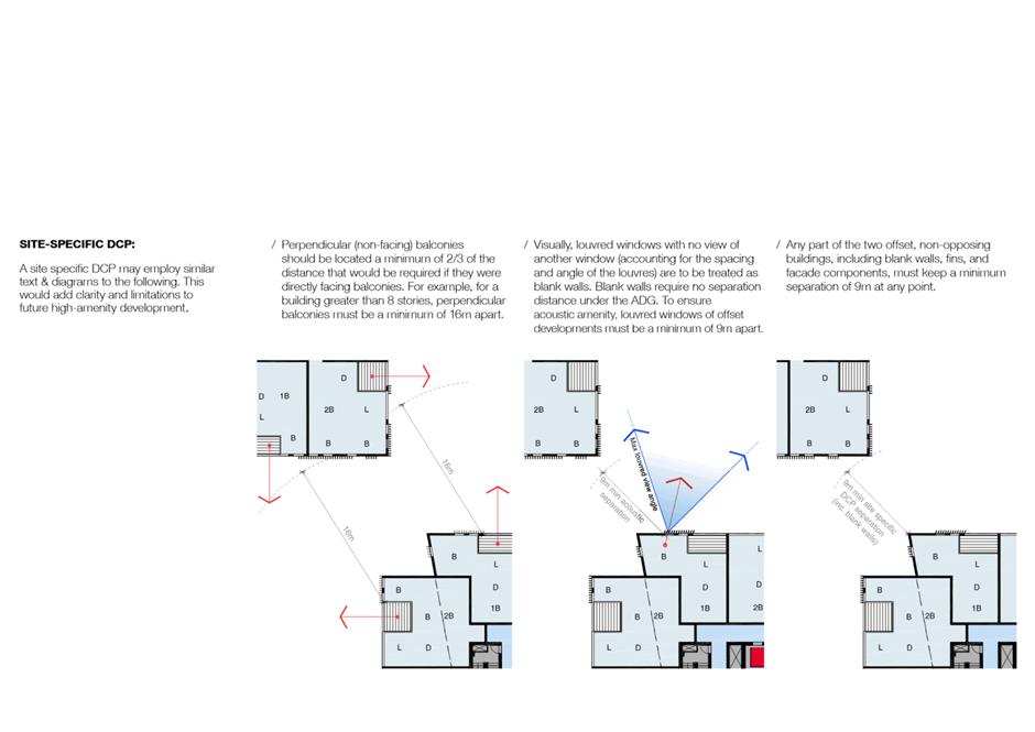
17. The two-tower scheme (shown in Figure 4) has a 3-4 storey podium and two offset towers of 28-32 storeys. This scheme does have some non-compliances with separation requirements set out in the Apartment Design Guide (ADG), as well as upper-level (i.e. tower) setback requirements set out in the Parramatta Development Control Plan (DCP) 2011. These non-compliances include:
a. Tower setback of 3m along Church St (the DCP specifies 4m);
b. Building separation between the upper levels of the two towers is 9-12m, which is less than that specified in the ADG (12-24m); and
c. Building separation between Ross Street tower and potential development at 383 Church St (discussed in further detail in a later section of this report).
18. Despite these non-compliances, Council officers consider that the scale of the towers and podium in the two-tower scheme is more sensitive to the local context, which includes Church Street, Heritage-listed Prince Alfred Square, and other nearby Heritage items. Council officers consider that the scale of the podium of the two-tower scheme is more appropriately matched with that of nearby buildings, and that dividing the mass between two towers creates a more appropriate relationship between towers on this site and other likely future development in the vicinity (as envisioned under the Parramatta CBD Planning Proposal). To illustrate this point, Figure 6 illustrates the massing of the preferred two-tower scheme within the outline (blue dashed line) of the massing of the one-tower scheme.
Figure 6: Two-tower scheme (solid massing) vs. one-tower scheme (blue dashed line)
Source: Applicant’s reference design
19. In conclusion, Council officers support progressing a two-tower scheme as the preferred reference design for this site based on the analysis above. It is recommended that an important focus for the Design Competition and Development Control Plan (DCP) processes for this site will be to minimise any non-compliances of a two-tower scheme.
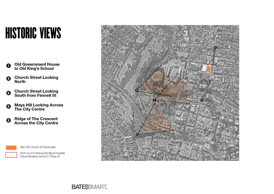
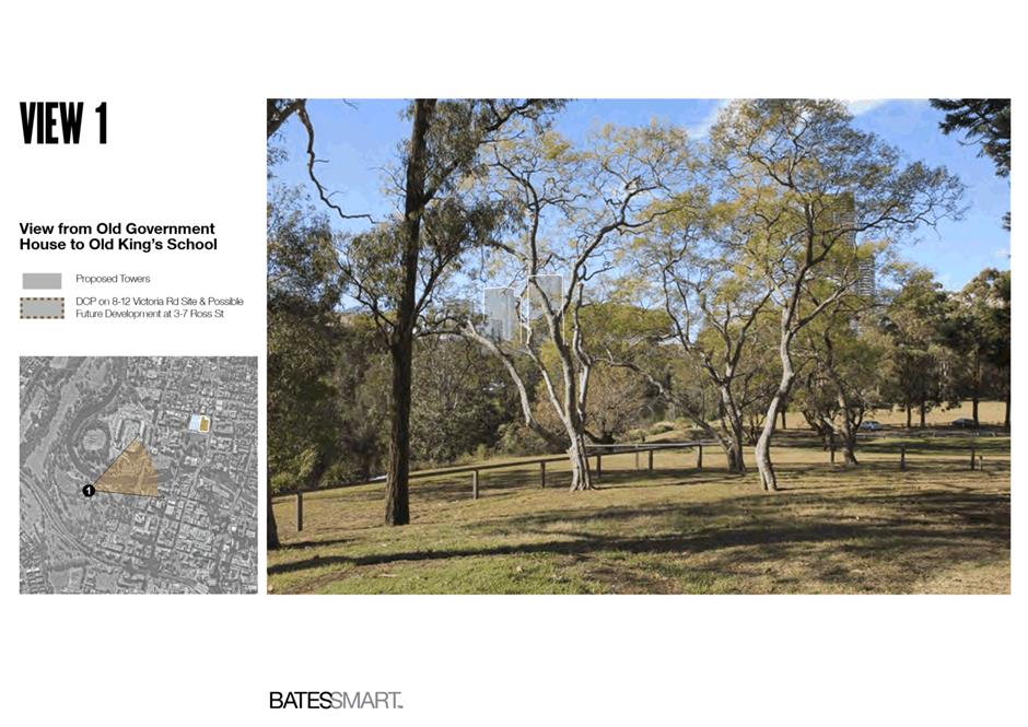
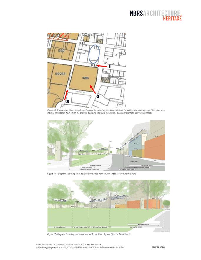
Heritage
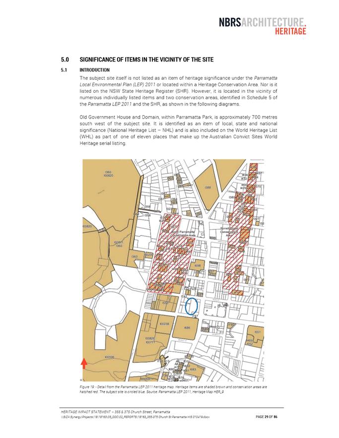
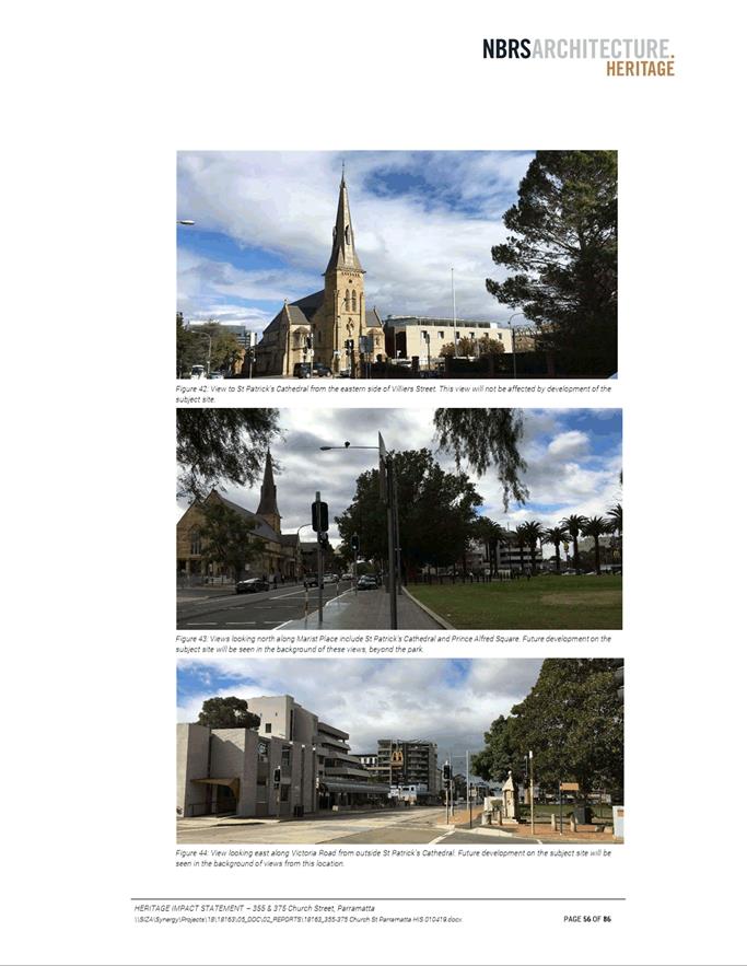
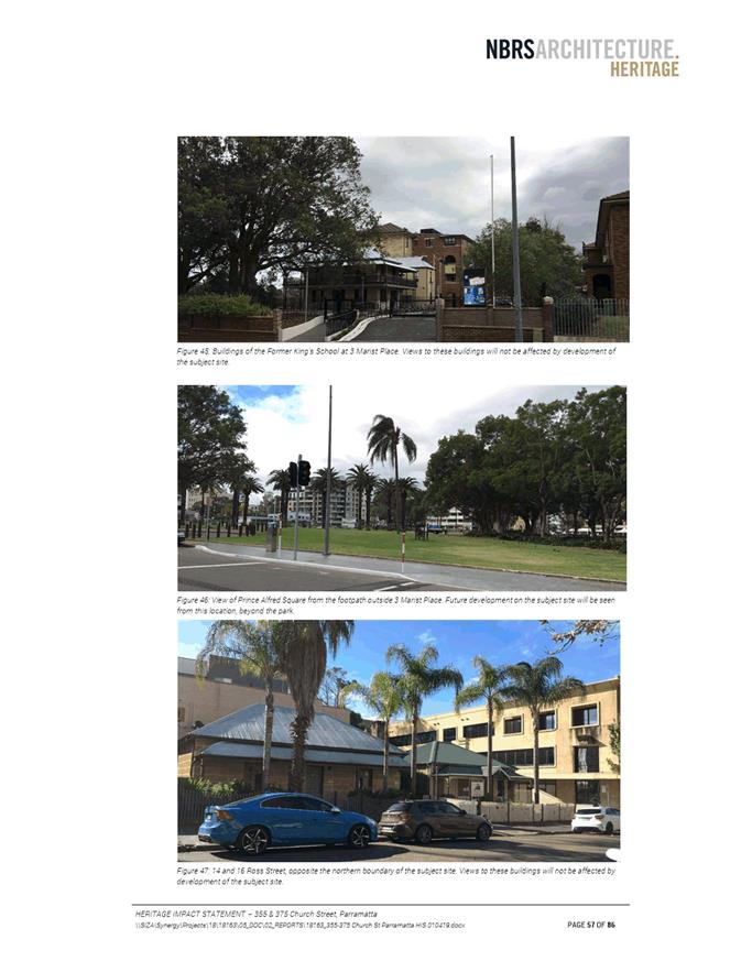
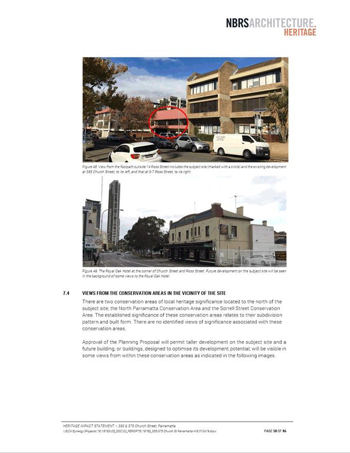
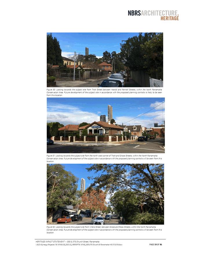
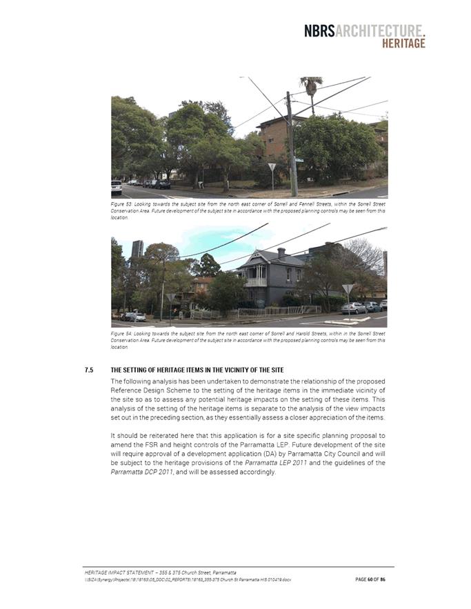
20. The Planning Proposal is located in close proximity to many Heritage-listed items; those items closest to the site are detailed in Figure 7 and Table 2. The nearest Heritage Conservation Areas to this site are the North Parramatta and Sorrell Street Conservation Areas, the borders of which are located approximately one block from the subject site to the northwest and northeast respectively (red hatching in Figure 7).
Figure 7: Extract of Council’s Heritage Map - subject site in blue
Source: Parramatta LEP 2011 (with added annotation for subject site)
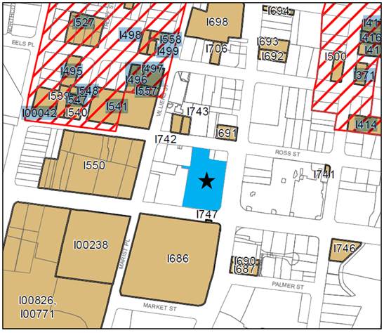
Table 2: Heritage Items located closest to site
|
PLEP 2011 Item no. |
Item (all Items are Local Heritage items unless noted as State–listed) |
|
I686 |
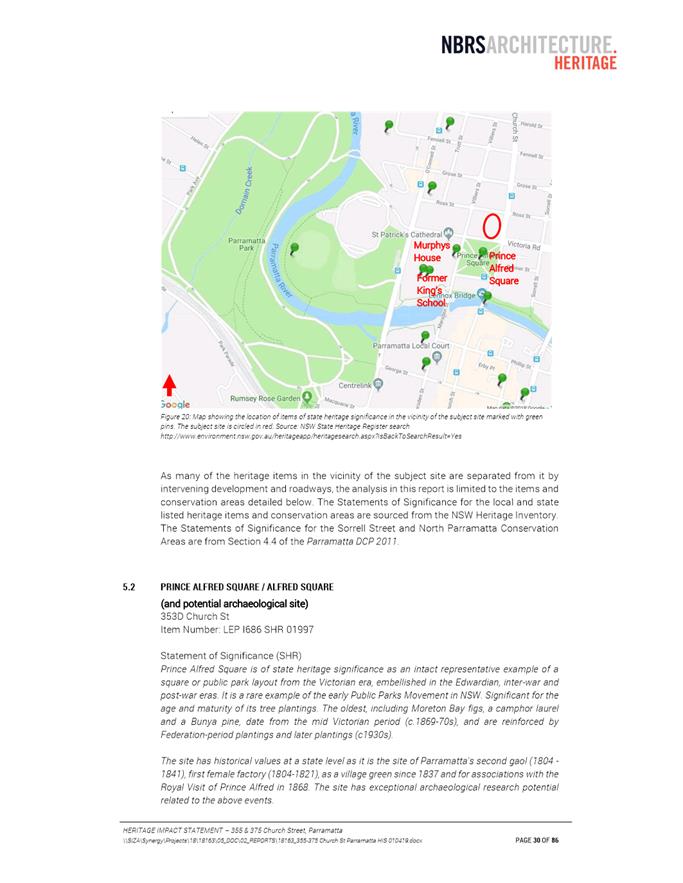
Alfred Square and potential archaeological site - State-listed item |
|
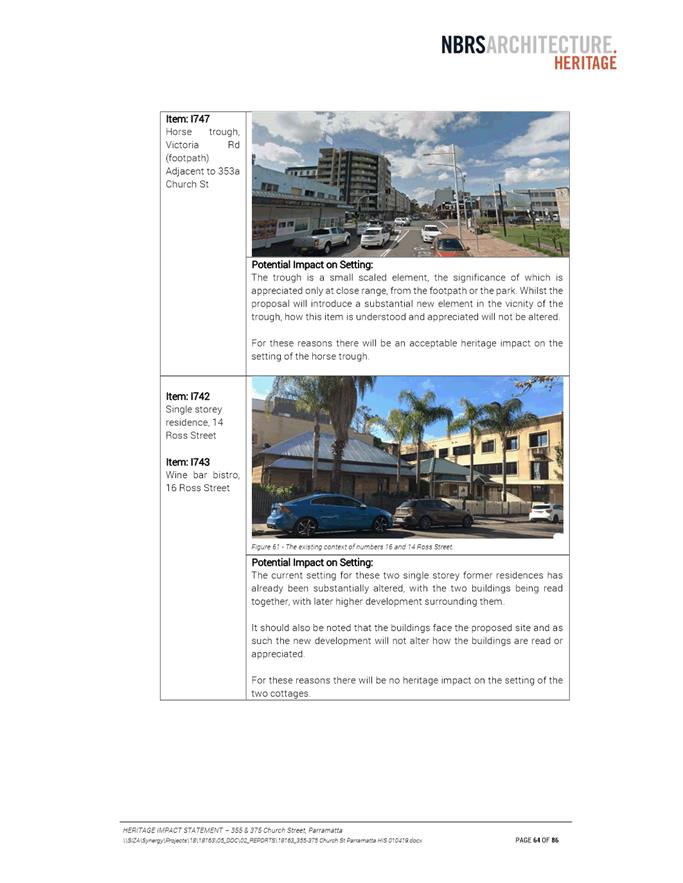
I747 |
Horse trough (adjacent to 353a Church St) |
|
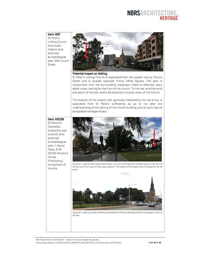
I687 |
St Peter’s Uniting Church and studio theatre (and potential archaeological site) |
|
I690 |
Anthony Malouf and Co |
|
I691 |
Royal Oak Hotel and stables (and potential archaeological site)* |
|
I742 |
Single-storey residence (14 Ross Street) |
|
I743 |
Wine bar bistro (16 Ross Street) |
|
I541 |
Lurlinea and potential archaeological site (8-10 Ross Street) |
|
I550 |
Convent of Our Lady of Mercy and associated buildings |
|
I00238 |
St. Patrick’s Cathedral, presbytery and precinct (and potential archaeological site) - State-listed item |
*The Hotel has recently been demolished as part of the Parramatta Light Rail project. The stables, which are of significance, remain on the site.
21. The applicant submitted a Heritage Impact Statement (HIS) alongside the Planning Proposal. The final version of the HIS is included at Attachment 6.
22. Council’s heritage officer has reviewed the proposal and requested that the proposal be consistent with the Parramatta CBD Planning Proposal. Given the proximity to Prince Alfred Square (a State-listed item), Council’s heritage officer also recommended that preliminary consultation be undertaken with the Office of Environment and Heritage (OEH).
23. OEH responded to Council officers’ referral with preliminary comments, which have been reviewed by Council officers and the Applicant. The Applicant has completed some additional work in response to these comments. For the information of the decision-makers, community and DPIE assessment staff, in Table 3 Council officers have copied OEH’s preliminary comments into this report and included a response.
Table 3: OEH preliminary comments and response
|
OEH Preliminary Comment |
Council Officer Response |
|
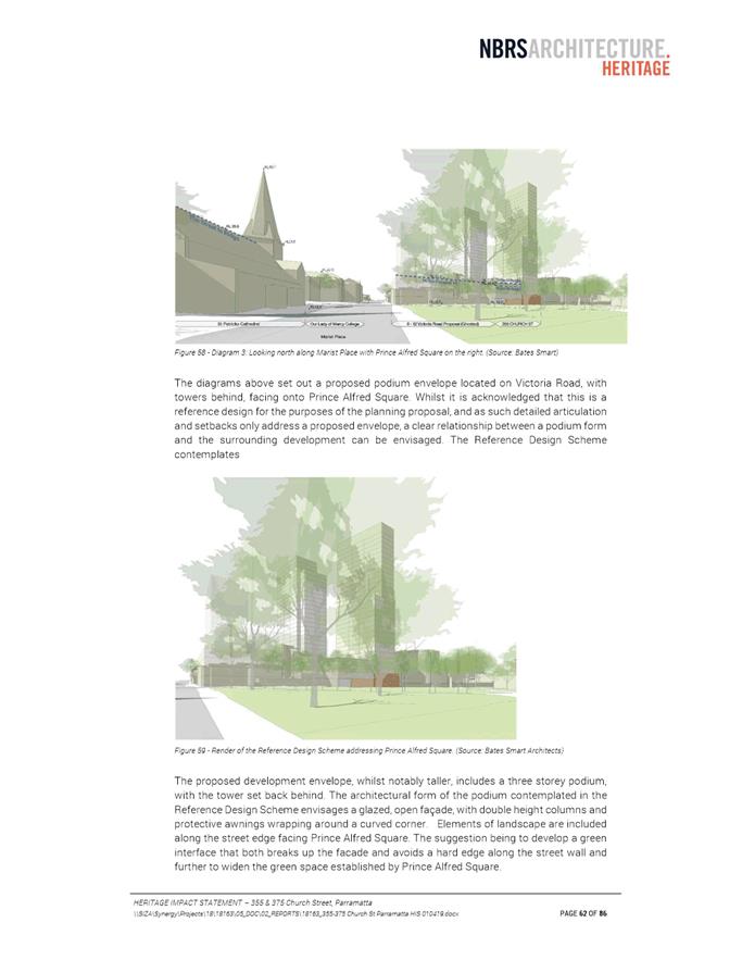
“The HIS has concentrated on the potential impact of the proposed development on views to and from the heritage items, more consideration needs to be given to assessing the impact of the proposal on the setting of heritage items in the immediate vicinity. Photomontages demonstrating the relationship between the new element and heritage items in the immediate vicinity should be provided in an updated HIS. The updated HIS should clearly articulate mitigation strategies recommended to reduce or avoid adverse impact on heritage items. Appropriate setbacks for the tower elements should be considered in the HIS. The proposed development should not overwhelm the neighbouring park or dominate vistas along Victoria Road.”
“[the HIS] ... discusses views to and from heritage items in the vicinity however the images provided to not show a representation of proposed to development. Photomontages would assist in the assessment of the potential impact on views to and from these items. An updated HIS should included photomontages showing the extent to which the proposed development can be seen in identified views. Representations of the proposed structures should be solid (not semi-transparent).”
|
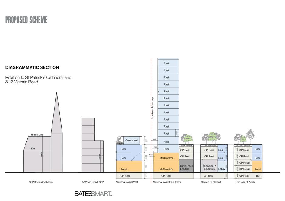
The Planning Proposal is consistent with the Parramatta CBD Planning Proposal, the formulation of which has taken into account impacts on heritage items.
The HIS originally submitted by the applicant has been updated to include a diagrammatic cross-section showing the relationship between the reference design’s podium and St. Patrick’s Cathedral.
The Planning Proposal considers changes to planning controls with a potential reference design envelope only (i.e. it does not consider detailed proposed development). Therefore, Council officers consider that a more detailed examination of impacts on heritage items (including issues such as setbacks, relationship to Prince Alfred Square, vistas, views etc.) and mitigation strategies should form part of later stages of this project, (including DCP, design competition and DA) when the specific nature of the proposed development is known. Officers also consider that photomontages are more appropriately included at those later stages of development (again, when the specific nature of the proposed development is known).
|
|
“Documentation accompanying the proposal indicates that large part of Prince Alfred Park will be overshadowed in winter as a result of the proposed development. This may impact on the use of this historic park and on its plantings. The concept design should seek to mitigate or avoid this impact. An updated HIS should address the impact of the overshadowing of the park on the significance of this item.” |
The Planning Proposal complies with the Prince Alfred Square SAP, which seeks to protect the southern half of Prince Alfred Square.
The Planning Proposal is considering changes to planning controls with a potential reference design envelope only (i.e. it does not consider detailed proposed development). Therefore, officers consider that further mitigation of the impacts on Prince Alfred Square should be investigated at later stages (including DCP, design competition and DA) when the specific nature of the proposed development is known. |
|
“The podium elevation should be appropriately articulated on its street frontages to avoid the creation of a ‘wall effect’ along the length of the site.” |
Officers consider that podium articulation is a design issue best addressed through the DCP and design competition stages. Nevertheless, the applicant has added further consideration of the podium’s relationship to nearby Heritage Items to the amended HIS; this discussion suggests a green interface with landscaping elements on the podium to break up the podium element and extend the green space established by Prince Alfred Square. |
|
“The Australian Government, the NSW Government and Parramatta City Council have signed a Conservation Agreement under the Environmental Protection and Biodiversity Conservation Act 1999 to protect the world and National Heritage values of Old Government House and Domain (OGHD) in relation to its significant views and settings. The Agreement requires that the findings of the Technical Report (Planisphere 2012) be implemented. Council should satisfy themselves that the requirements of the Conservation Agreement have been met.”
“The HIS identifies that the proposed development is within the ‘sensitive’ zone for views from Old Government House and Domain. The Technical Report includes design requirements that proposed development should address. An updated HIS should demonstrate how the proposed development meets these requirements.” |
The outcome of the analysis and discussions between Council and the State, Federal Agencies when formulating the Conservation Agreement described by OEH is that only the sites in the Area of Special Significance (a precinct located south west of the subject site) would be subject of the agreement. Outside this precinct Council could continue to plan to allow growth in other parts of the Parramatta CBD without having to refer the changes to the Federal Government under the Environmental Protection and Biodiversity Conservation Act 1999. The Area of Special Significance is the most significant precinct when it comes to the world and National Heritage values of Old Government House and Domain (OGHD).
The impacts of growth outside the Area of Special Significance were considered in the Heritage Study prepared by Urbis (2015) undertaken as part of the Parramatta CBD Planning Proposal. The conclusion of this study was that the growth proposed in the Parramatta CBD Planning Proposal does not have any significant impact on the world and National Heritage values of Old Government House and Domain (OGHD).
The Planning Proposal does not propose development; it proposes to change planning controls consistent with the Parramatta CBD Planning Proposal. One of the factors considered in preparation of the Parramatta CBD Planning Proposal were the various planning requirements relating to OGHD. |
|
“An archaeological assessment may be required. Depending on the recommendations of the assessment further archaeological investigation maybe recommended prior to commencement of works. It is desirable that intact State significant archaeology be retained in situ.” |
Broadly, the Planning Proposal does not change the potential archaeological impacts in comparison to the current planning controls for this site, as this site already has significant development potential under current controls. The Planning Proposal is seeking to allow more height and floorspace on the site. The site would be subject to archaeological assessment at DA stage, whether developed under current planning controls or the controls envisaged by the Planning Proposal. Therefore, it is not considered that an archaeological assessment is required at Planning Proposal stage. Consistent with officers’ approach to other similar site-specific Planning Proposals in the Parramatta CBD, officers recommend that archaeological matters are dealt with at DA stage. |
24. Council officers acknowledge that some of the extra work requested by OEH in their preliminary comments was not completed at this initial stage of the Planning Proposal process. Pending a Gateway determination that authorises exhibition, OEH will be asked to comment formally on this Planning Proposal. OEH will have the opportunity at that point to revisit the preliminary comments made on this proposal, review the work done by the applicant in the interim, and make formal comment about any outstanding matters. Furthermore, DPIE consults Government agencies prior to issuing Gateway determinations as required, so it is assumed that OEH would have an opportunity to provide DPIE with advice about any necessary Gateway conditions with respect to heritage if DPIE considered this was necessary prior to issuing a Gateway determination.
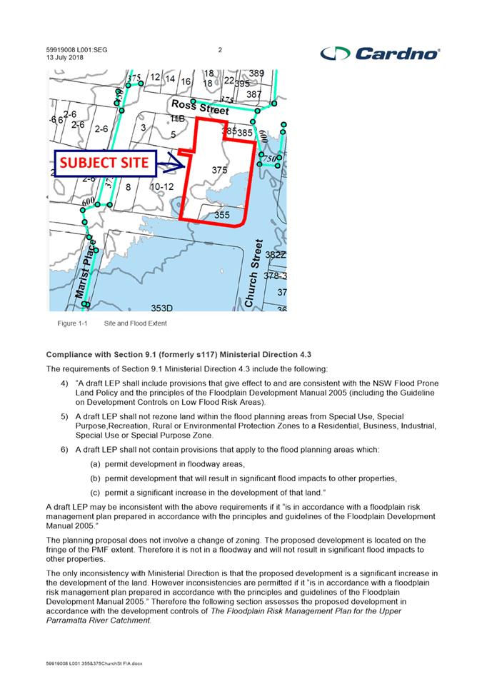
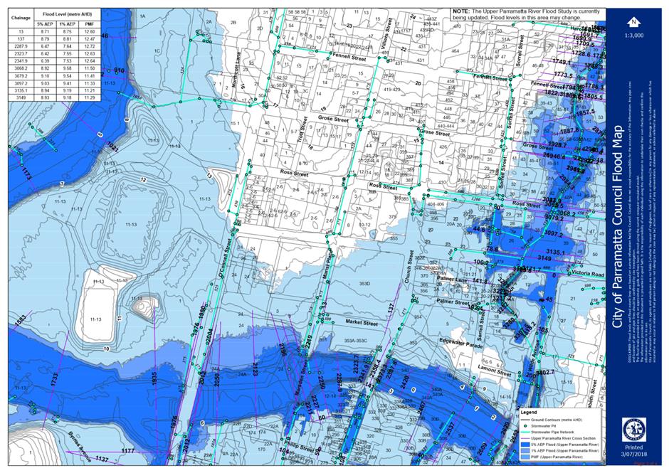
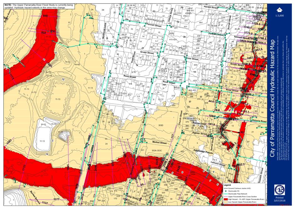
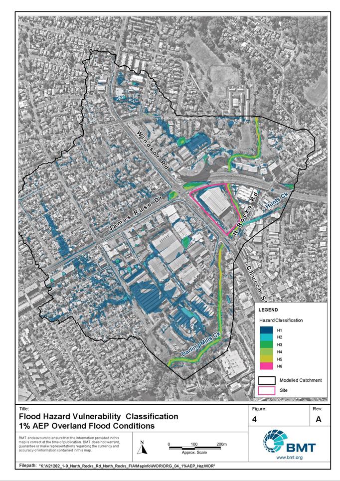
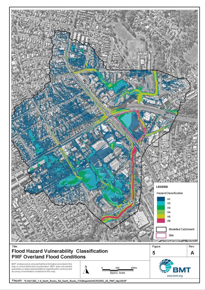
Flooding
25. As illustrated in Figure 8, a portion of the site is within the area of the Probable Maximum Flood (PMF). However, the site is not affected by the 100-year Average Recurrence Interval (ARI) flood area (i.e the “1%” flood zone).
Figure 8: Portion of site affected by PMF (denoted with light blue shading)
Source: Council’s internal mapping (subject site outlined in red)
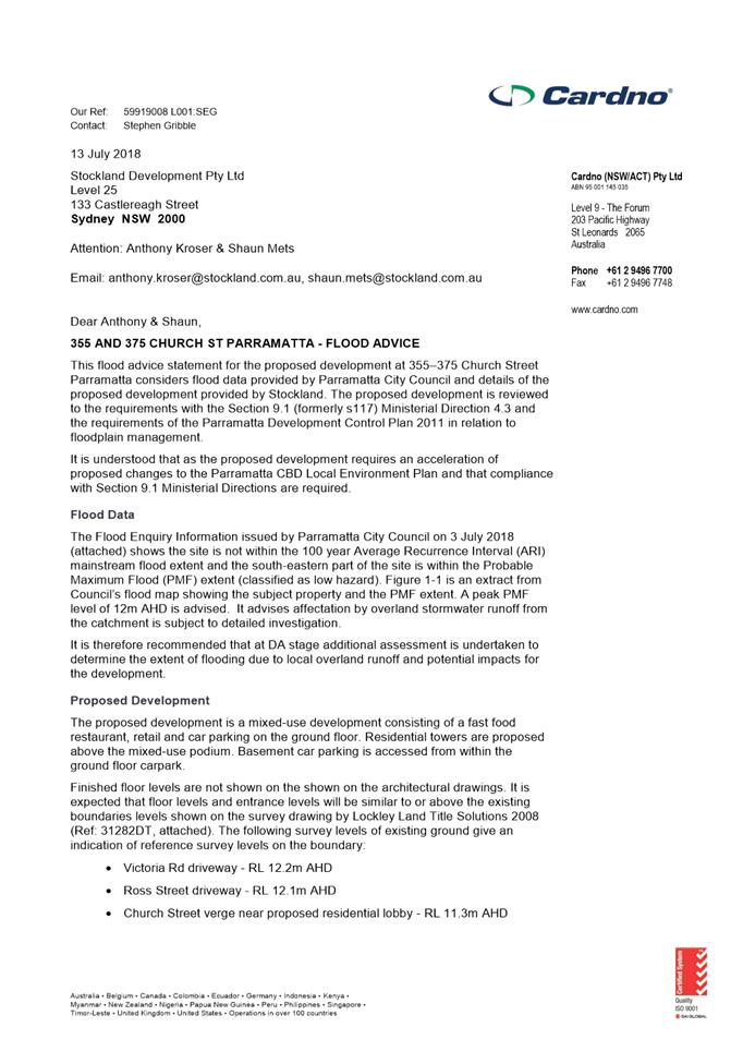
26. Council officers have reviewed the applicant’s flood assessment (Attachment 5) submitted with the Planning Proposal. Council officers consider that river flooding is not an impediment to progression of this Planning Proposal, and that any overland flow issues can be addressed as part of a future DA process.
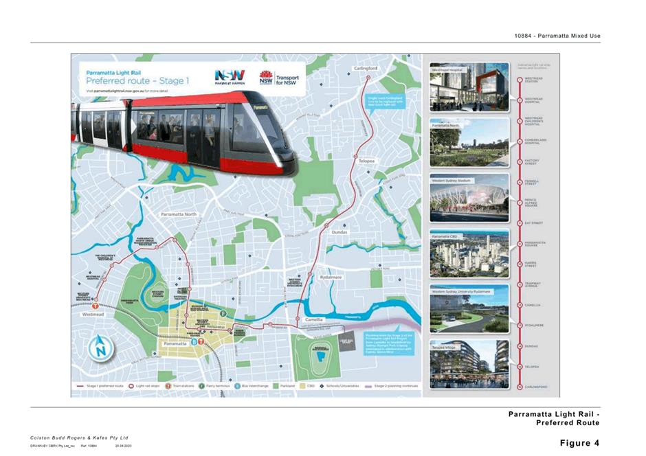
Interface with Parramatta Light Rail (PLR)
27. Council officers undertook a preliminary referral to Transport for NSW (TfNSW) given that the site is adjacent to the PLR Stage 1 corridor. TfNSW responded requesting further work relating to traffic impacts on the site. Council officers clarified with TfNSW which elements of the requested further work are relevant at Planning Proposal stage, and these elements are detailed in Table 4 along with an officer response.
Table 4: TfNSW preliminary comments and response
|
TfNSW Preliminary Comment |
Council Officer Response |
|
“A Traffic Impact Assessment should consider the existing and future performance of key intersections providing access to the site, supported by appropriate modelling and analysis to the satisfaction of RMS and TfNSW. The TIA should include proposed measures to mitigate impacts of the proposed development on the operation of existing and future traffic, public transport, pedestrian and bicycle networks including any required upgrades.” |
The Applicant has submitted a traffic assessment that examines existing and future performance of key intersections. TfNSW will have the opportunity to comment formally on this assessment as part of agency referral and can identify any additional measures required for the satisfaction of transport agencies through that process. |
|
“The TIA should include an assessment of any impacts of the development on the Parramatta Light Rail (PLR). During the construction and operation phases of the Parramatta Light Rail (PLR) there will be intermittent, short and long term road closures as well as material changes to road network operations. These changes may impact pedestrian, cyclist and vehicular access routes to the proposed development and should be included in any analysis.” |
Council officers agreed with TfNSW’s view that the Applicant should review the PLR Environmental Impact Statement (EIS) and related documents in greater detail, and consider these in an amended traffic assessment. This review has been undertaken and the Applicant’s traffic assessment has been updated to include changes to the road network as a result of the PLR (in particular the changes to the intersection of Victoria Road and Church St). |
28. TfNSW has agreed with Council officers that the other matters raised in their preliminary comments (pertaining to issues such as sustainable transport options, construction management arrangements, and accommodation of freight and services) could be addressed at DA stage when the specific nature of the proposed development is known.
29. This site was originally proposed for partial acquisition under the PLR Stage 1 EIS to facilitate road widening. Following a more detailed design review of property impacts, TfNSW formally advised the applicant that PLR would not require road widening at this site. This advice has been shared with Council officers. Therefore, no concern is raised with the need for road widening in relation to PLR.
30. Based on the above, Council officers do not consider PLR an impediment to this Planning Proposal’s progress. As noted previously in relation to preliminary comments from OEH, it is envisiged that TfNSW will have the opportunity to make formal comment to DPIE (if required as part of the Gateway determination process) and to Council (as part of the exhibition process) later in the Planning Proposal process.
Traffic and Access Issues
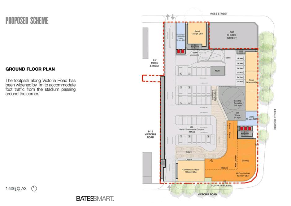
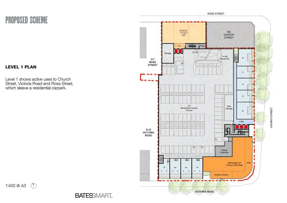
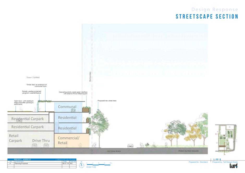
31. As shown in Figure 9, the reference design envisages dual vehicle access from both Victoria Road (entry) and Ross Street (entry and exit), with retention of a drive-through facility located within the podium. The drive-through is integrated into the basement design and sleeved by lobbies and commercial/retail uses.
Figure 9: Ground floor plan demonstrating access and drive-through arrangements
Source: Applicant’s reference design
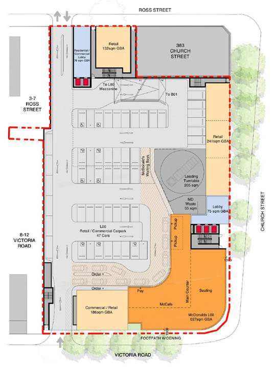
32. The applicant has submitted a traffic report alongside the Planning Proposal (refer Attachment 4). This report concludes that, in comparison to current traffic generation on the site, the reference design will result in a reduction of traffic during peak periods. Council officers queried the conclusions related to reduced traffic generation in an earlier version of the traffic report, and the applicant responded that this is due to the reduction in traffic generation from the redeveloped McDonald’s restaurant offsetting the future traffic generation of the new uses at the site.
33. Council’s traffic team requested that the applicant acknowledge that the right turn entry into the site from Victoria Road may be restricted in the future if this movement impacts on the traffic performance of Victoria Road. The applicant has acknowledged this point in a written response to Council.
34. Council’s traffic and transport officers have requested that sightlines, vehicle queueing, pedestrian safety and bicycle parking are addressed in further detail. It is recommended that these matters are addressed in future site-specific DCP, Design Competition and DA processes for this site.
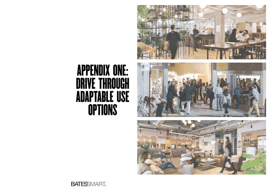
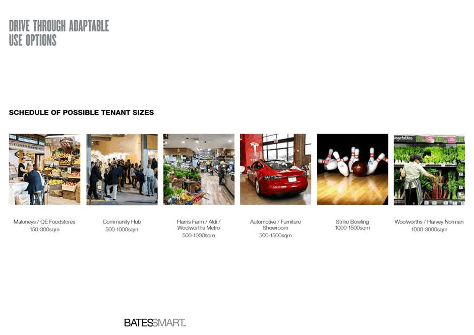
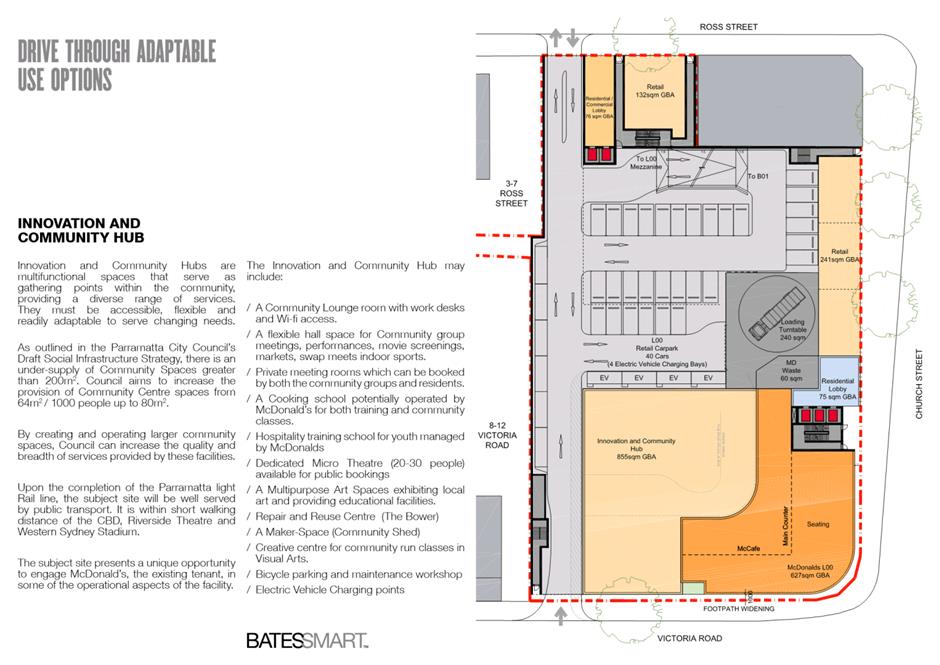
35. Given concerns about vehicle congestion and the need to rebalance transport habits towards active transport in a growing CBD identified in Council’s strategic transport work, Council officers raised the concern that the drive-through facility associated with the McDonald’s restaurant may not be the optimal long-term outcome for this site. The applicant responded to this view by demonstrating their consideration of future adaptive re-uses for the drive-through facility, should it no longer be commercially desirable in the future. This response is included in the reference design at Attachment 2, and Council officers recommend that this matter is considered further during preparation of the site-specific DCP and Design Competition brief.
36. In the view of Council officers, the above matters have been addressed satisfactorily for the purposes of progressing a Planning Proposal. The final assessment matter relating to traffic relates to the parking rates applied in the Planning Proposal, and the next section of this report addresses this matter in more detail.
Parking Rates
Introduction
37. In April 2017, Council endorsed parking rates to be applied to site-specific Planning Proposals seeking to progress ahead of the Parramatta CBD Planning Proposal and the related Integrated Transport Plan (ITP) for the Parramatta CBD. These rates have since been included in the provisions of the Parramatta CBD Planning Proposal (endorsed by Council November 2019), and are currently as follows:
a. Maximum parking rates for residential uses:
Studio: 0.1 spaces/dwelling
1 bedroom: 0.3 spaces/dwelling
2 bedroom: 0.7 spaces/dwelling
3 bedroom: 1 space/dwelling
b. Maximum parking rate for commercial (i.e. retail, business and office) premises for buildings on land where the FSR is greater than 3.5:1:
M = (G X A) / (50 X T)
Where:
M is the maximum number of parking spaces,
G is the gross floor area of all commercial uses in the building in sqm,
A is the site area in sqm, and
T is the total gross floor area of all buildings on the site in sqm.
38. The initial version of the subject Planning Proposal lodged with Council requested higher maximum parking rates than those cited above. Following assessment and further discussion with the Applicant, the Planning Proposal now contains rates consistent with the above rates, with the exception of the Take Away Food and Drink Premise use for which a specific parking rate is proposed. The parking rates for each of the land uses proposed on this site are discussed in turn in the following sections.
Residential parking rate
39. The Applicant expressed concern that market conditions in Parramatta require more residential parking than the aforementioned maximum rate. In particular, the Applicant submitted market research indicating that two-bedroom residential units require a parking space to sell in current market conditions. This information was reviewed by Council officers and is noted.
40. For site-specific Planning Proposals seeking to progress ahead of the Parramatta CBD Planning Proposal, Council officers continue to support the aforementioned residential parking rate. This rate has been consistently applied to other site-specific Planning Proposals and continues to be part of the Parramatta CBD Planning Proposal as the ITP is not complete. This precautionary approach is considered necessary until the ITP either confirms or amends these rates.
41. While the Applicant’s preference would be to provide more residential parking, they have accepted the maximum residential parking rate cited above in order to progress the Planning Proposal, and submitted an amended traffic report responding to these rates. Therefore, this component of the Planning Proposal is supported by Council officers.
Commercial parking rate (excluding Take Away Food and Drink Premises use)
42. For those commercial uses proposed - with the exception of the Takeaway Food and Drink Premise use - the Applicant has accepted the aforementioned formula to determine the number of spaces. Applying the formula so as to exclude the Take Away Food and Drink Premise use results in this component of the development having approximately 1 parking space.
43. This is generally consistent with rates endorsed by Council for site-specific Planning Proposals, as well as the current draft controls within the Parramatta CBD Planning Proposal. Therefore, this component of the Planning Proposal is supported by Council officers.
Take Away Food and Drink Premises Parking Rate
44. The proposed parking rate for Take Away Food and Drink Premises in the Planning Proposal at Attachment 1 is a maximum of 1 parking space / 30 sqm of GFA, or 30 parking spaces, whichever is less. It is also recommended that a five-year sunset clause apply to this rate. The process by which this rate was determined is described below.
45. The Applicant initially proposed applying the current Parramatta LEP 2011 parking rate for drive-in take away food and drink premises with seating, which is a maximum of one parking space/10sqm of gross floor area or one parking space/six seats (whichever is less). This would have resulted in about 34 parking spaces for the Take Away Food and Drink Premises use.
46. During assessment of the Planning Proposal, Council officers initially requested that all commercial uses (i.e. including the Take Away Food and Drink Premises use) conform to the formula for commercial uses cited in paragraph 37 of this report. Under the original reference design, this would have resulted in a total of approximately six (6) car parking spaces for all commercial uses on site, including approximately three (3) for the Take Away Food and Drink Premises use.
47. The Applicant has indicated that this outcome is not commercially viable for the landowner (who would operate the restaurant), and would therefore prevent the redevelopment of this site in the short to medium term. Therefore, whilst the Applicant accepted the application of the formula for other commercial uses proposed, they requested the opportunity to propose and provide justification for a specific rate for the Take Away Food and Drink Premises use.
48. Council officers provided the Applicant with the opportunity to propose and provide justification for a specific rate, due to the following considerations:
a. Parramatta LEP 2011 currently contains a parking rate relevant to the proposed use, however, the draft controls currently contained in the Parramatta CBD Planning Proposal do not. This is because the draft Parramatta CBD Planning Proposal adopts City of Sydney rates, which do not include a specific rate for the use in question. Council officers acknowledge that the list of uses within the draft controls of the Parramatta CBD Planning Proposal may need to evolve through the exhibition and finalisation process, and this may be one such case reflecting this issue.
b. This site is currently the only Take Away Food and Drink Premise with a drive through and seating located on an arterial road in the Parramatta CBD Planning Proposal area. Setting a rate for this specific land use at this particular site does not set a precedent for reconsidering the parking rates otherwise consistently applied to site-specific Planning Proposals seeking to proceed ahead of the Parramatta CBD Planning Proposal.
c. Developing a bespoke rate for this use at this site provides an opportunity to “unlock” redevelopment of this site in line with the Parramatta CBD Planning Proposal, whilst carefully balancing this with traffic impacts.
d. A bespoke rate for this land use is considered appropriate so that development assessment officers have an appropriate tool for considering any future DA involving this land use.
49. The Applicant proposed a rate of 1 space / 30 sqm, which would facilitate provision of 30 parking spaces for the Take Away Food and Drink Premises use under the reference design. This justification was based in part on a benchmarking exercise of parking controls from across various jurisdictions in Sydney and Australia that showed a wide range of potential outcomes from 15-60+ parking spaces for this use if applied at this site. Key details of this benchmarking exercise are referred to later in this section.
50. In response to the above proposal, Council officers communicated the following position back to the Applicant:
· Council officers do not have any strong reservations in terms of traffic generation of the proposed rate, noting that 30 parking spaces is a significant reduction on the current amount of parking on site (approximately 60 spaces) and a marginal reduction on the parking rates for the use under current planning controls (approximately 35 spaces).
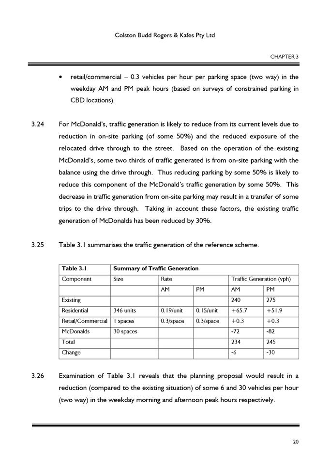
· Despite the above, Council officers have concerns about the proposed rate that stem from the perspective of (a) strategic vision and (b) precedent.
· With regards to strategic vision, Council officers note that the rate proposed would result in parking provision of 30 spaces, which is greater than the provision that would result in many of the centres identified in the Applicant’s benchmarking analysis, including Sydney CBD (fringe) (13.5 spaces), Burwood (13.5), Green Square (13.5), North Sydney (16-18), Crows Nest (18), Kogarah (20), and Lane Cove (22.5). Officers are concerned that accepting a rate greater than this group of centres would not align with the longstanding imperative to grow Parramatta CBD as Sydney’s Central City and achieve the vision of a true CBD of metropolitan - and even global - significance.
· With regards to precedent, Council officers are concerned that accepting car parking rates that do not align with Council’s established strategic framework would set a precedent that risks putting Council into the position of having to regularly renegotiate the rates in the Parramatta CBD Planning Proposal.
· However, Council officers recognise a shared vision to see this site redeveloped in line with the Parramatta CBD Planning Proposal and acknowledge both the realistic pressures of development feasibility and the unique characteristics of this site.
· Taking into account the above, Council officers suggested that a compromise position of 1 space / 45 sqm (resulting in approximately 20 parking spaces) would be more aligned with the parking rates for the aforementioned group of centres and would more easily supportable.
51. In response to Council officers’ position, the Applicant has stated that (due to development feasibility issues) development would not proceed if the parking rate for the Take Away Food and Drink Premise use was 1 space / 45 sqm (about 20 spaces).
52. Council officers’ position remains that a parking rate of 1 space / 45 sqm (about 20 spaces) would be more aligned with strategic goals for the Parramatta CBD that envisage significant mode shift away from vehicles and towards active transport. Nevertheless, officers are prepared to support the Applicant’s proposed rate (1 space / 30 sqm or about 30 spaces) on the following basis:
a. Council officers acknowledge the broader shared vision for this site, which is to see it redeveloped in line with the Parramatta CBD Planning Proposal (with which the proposal is otherwise consistent);
b. Council officers acknowledge the Applicant’s position relating to feasibility, which is that the blanket commercial parking rate formula otherwise applied in the Parramatta CBD Planning Proposal would make this development unviable in the short term. Council officers consider that car parking vs. active transport is one of many “transitional” issues facing the City as it assumes the role of Sydney’s Central City over the coming years. In other words, the viability of this development as proposed at present remains dependent on vehicle traffic. However, it is considered that the business model for this and many other vehicle-dependent businesses will necessarily rebalance toward active transport in coming years as (a) new public transport infrastructure comes on line and (b) a mix of public and active transport modes become the most viable transport option in to, out of and around the Parramatta CBD (given the significant increases in development).
c. The proposed rate results in a decrease of approximately 50% in on-site parking associated with this use, and the traffic report states that the net result of the development will be a reduction in vehicle traffic during the peak.
d. The Applicant has already completed conceptual work demonstrating how the drive through could be adapted to other uses in the future, and it is considered that this work could be extended to include at least some of the proposed parking.
e. Appropriate limits could be applied to the Applicant’s proposed rate at clause drafting stage, as follows:
i. Structuring the control to limit the parking to 1 space / 30 sqm or 30 spaces, whichever is less. This ensures that the number of spaces is capped at the 30 spaces, even if the size of the use increases at DA stage. It will also scale down the number of spaces if the size of the restaurant ends up being smaller than currently anticipated.
ii. Placing a 5-year “sunset” clause on this parking rate, after which time the control would revert to the blanket commercial rate applied to the rest of the commercial uses through the Parramatta CBD Planning Proposal process. This ensures that, should the Applicant not gain planning permission for development within 5 years of finalising this LEP amendment, the parking question would be reconsidered. During that time, it is anticipated that Council will have established a final parking rate regime through the finalisation of the CBD Planning Proposal, and by which time development feasibility calculations may have changed based on transport mode shifts in the CBD.
53. In summary, the Planning Proposal recommended at Attachment 1 contains a rate for the Take Away Food and Drink Premises use of 1 parking space / 30 sqm GFA or 30 spaces (whichever is less), and includes a 5-year “sunset” clause provision.
54. Finally, Council officers note preliminary advice from DPIE and Transport for NSW as to how such a proposed variation to the draft Parramatta CBD Planning Proposal rates might be viewed by State agencies as part of a Gateway assessment. These agencies have advised that they are generally not supportive of such variations, and the Applicant has been made aware of this position. Nevertheless, given the assessment provided above, Council officers do not object to establishing a specific rate for this use at the pre-Gateway stage. This will be assessed by DPIE and relevant State agencies as part of their Gateway assessment.
Active Street Frontage
55. Under the Parramatta CBD Planning Proposal, this site is affected by Active Frontages controls along the Victoria Road and Church St frontages (refer Figure 10). The draft controls for Active Frontages state that all premises on the ground floor of the building facing the street and any public spaces are to be used for the purposes of business or retail premises, community facilities, or entertainment facilities. Entrances/lobbies, services and related access, and vehicular access points are excluded from this requirement.
Figure 10: Active Frontages Map (active frontage requirement denoted in red)
Source: Parramatta CBD Planning Proposal (as at time of report writing)
56. The reference design for this Planning Proposal meets this requirement, in that it proposes commercial/retail facilities along the Victoria Road and Church Street frontages. Parking and drive-through facilities located in the podium are sleeved by active uses. Council officers support these aspects of the reference design, and recommend incorporation of the same into the future DCP and Design Competition brief for this site.
Isolated Site
57. As noted previously in this report, this Planning Proposal does not include land located at 383 Church Street, Parramatta (i.e. on the corner of Ross Street and Church Street). Council officers consider that the optimal urban design outcome for these sites would be amalgamation and holistic redevelopment. However, the planning system cannot enforce this outcome. Council officers have requested that the Applicant engage with this isolated site issue through two means, namely:
a. Demonstrating the redevelopment potential of the isolated site
b. Demonstrating efforts towards meeting the NSW Planning Principle for addressing isolated site issues (a requirement for any future DA process at this site).
Potential redevelopment of the isolated site
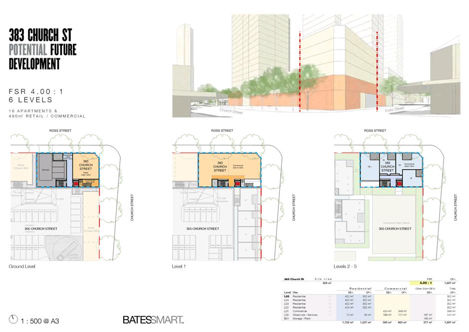
58. While the planning system cannot enforce site amalgamation outcomes, they can be encouraged through levers such as the Parramatta CBD Planning Proposal’s FSR “sliding scale” which encourages site amalgamation and better urban design outcomes by limiting the development potential of small sites. Under the sliding scale, 383 Church Street would have an FSR of 4:1 if developed on its own. If developed with the adjoining site that is the subject of this Planning Proposal, it would have an FSR of 6:1.
59. The applicant has completed urban design analysis demonstrating the development potential of the 383 Church Street at an FSR of 4:1. This is included at Attachment 2. The resulting building is a 6-storey building with 0m setbacks to the shared boundaries.
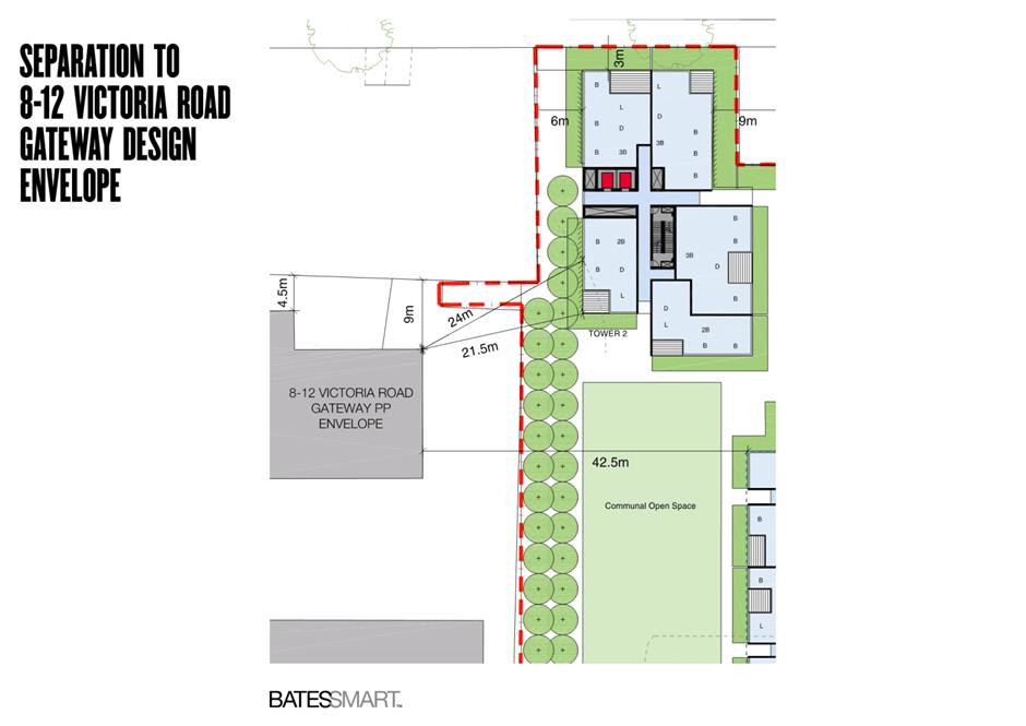
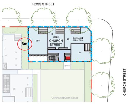
60. Officers have identified a potential building separation issue leading to amenity impacts between the northern tower in the two-tower reference design and potential redevelopment at 383 Church St. As demonstrated in Figure 11, there is a 3m separation between the units in the northwest corner of this tower and the potential redevelopment at 383 Church St. It is recommended that this matter is resolved in the DCP, acknowledging that the best solution may be for the lower levels of the northern tower to provide a 0m setback to the shared lot line at this point.
Figure 11: Illustration of upper level setback issue between reference design scheme and adjacent potential redevelopment of 383 Church St
Source: Applicant’s Reference Scheme with annotation by Council officers
Addressing NSW Planning Principle for isolated sites
61. As 383 Church Street would be considered an isolated site at DA stage, Council officers requested that the applicant begin the process to address the NSW Planning Principle relating to isolated sites (which is a requirement at DA stage). In demonstrating their engagement with the site isolation issue, the applicant has submitted copies of valuations and offers that were made to the landowner of 383 Church St, both as part of the previous DA process at this site, as well as just before lodgement of the current Planning Proposal. This information is noted.
Isolated site – conclusion
62. While Council officers consider that amalgamation of these sites would likely facilitate a better planning outcome, Council officers do not consider that the isolated site issue should be an impediment to the progress of this Planning Proposal, as the Applicant has demonstrated that the isolated site can develop in line with the sliding-scale provisions of the Parramatta CBD Planning Proposal.
63. The landowner of 383 Church Street will be notified as part of the public consultation process for this Planning Proposal, and will have the opportunity to formally respond to Council regarding their position at that time. Furthermore, Council officers will notify the landowner of 383 Church Street of this report to the LPP, and will continue to communicate with this landowner about reports concerning this Planning Proposal.
64. Based on experience with processes for other site-specific Planning Proposals that are adjacent to isolated sites, Council officers consider it possible that DPIE will direct the inclusion of 383 Church St in this Planning Proposal through the conditions of a future Gateway determination. In this instance, officers consider it would be prudent to request that sliding-scale provisions consistent with the Parramatta CBD Planning Proposal are also included in an amended Planning Proposal, as it is not expected that these two sites would amalgamate in the near future.
65. Council could make a decision to include 383 Church St to pre-empt a potential decision by DPIE to have it included. However, this option results in further potential cost and delay for the applicant. Inclusion of this site would require documents to be reviewed and amended to include 383 Church St prior to any consultation process. Council officers consider that it is not justified to require the applicant to incur this cost unless DPIE deems it necessary.
Other statutory considerations
66. The proposal has been assessed against the statutory considerations including relevant local and regional strategies and planning policies and relevant Ministerial directions. Details of the assessment of these matters is included in the Planning Proposal provided at Attachment 1.
Conclusion of officer assessment of Planning Proposal
67. In conclusion, based on the analysis summarised in previous sections, Council officers recommend progression of this Planning Proposal.
68. Council officers also recommend that Council advise DPIE that the CEO will not be exercising the plan-making delegations for this Planning Proposal. This is on the basis that Council is also advancing the Parramatta CBD Planning Proposal (which affects this site), and the Parramatta CBD Planning Proposal has not yet been approved by DPIE for finalisation.
PLANNING AGREEMENT
69. The Applicant has provided an initial letter of offer that accepts valuing the total public benefit to be provided under a future Planning Agreement to be calculated at a rate of $150/sqm of additional approved gross floor area (GFA) above the “base” FSR.
70. The $150/sqm rate proposed is consistent with the Community Infrastructure framework established through the Parramatta CBD Planning Proposal process.
71. The Applicant’s proposed approach to calculating the monetary contribution allows for flexibility as part of the DA process, wherein the final quantum of GFA approved will more than likely differ from a strict theoretical calculation converting the maximum permissible FSR into a GFA figure. For instance, detailed design may result in a building that is slightly less than the overall FSR; on the other hand, the applicant might pursue a minor variation to the FSR control through a Section 4.55 variation that results in a building with slightly more FSR than the controls. It is considered that the Planning Agreement should have the flexibility to respond to either scenario, and should therefore contain provisions calculating the final contribution to be payable based on the GFA approved at Development Application stage (on a $150/sqm basis). A recent precedent for this was set in the Planning Agreement negotiations for 14-20 Parkes St, Harris Park.
72. To give an indication of potential value of the Planning Agreement, Council officers have also undertaken a calculation of the value based on the increase from current FSR controls to future FSR controls (excluding Design Excellence bonus). This calculation is shown in Table 5 and takes into account that two different parts of the site have different “base” or current FSRs. As noted above, calculating this value based on the amount of GFA ultimately approved means that the final value of the VPA would likely vary somewhat from this amount; however, the below estimate provides an indication of the likely final value.
Table 5 – Estimate of likely value of Planning Agreement
|
|
Land Area |
Base FSR |
Planning Proposal FSR (excluding Design Excellence bonus) |
Value based on $150/sqm of FSR uplift |
|
Parcel A |
659 sqm |
4:1 |
6:1 |
$ 197,700 |
|
Parcel B |
4,137 sqm |
3:1 |
6:1 |
$ 1,861,650 |
|
Total |
4,796 sqm |
|
|
$ 2,059,350 |
73. While the value of the Planning Agreement contribution offer is consistent with Council policy framework, the detailed content of the agreement is still to be negotiated. However, it is noted that the Applicant and Council officers have already discussed two potential land dedications with the Applicant, namely:
a. A footpath widening dedication of width up to 1m at the corner of Church Street and Victoria Road to support increased pedestrian traffic in this area, and
b. The dedication of the small irregularly-shaped “notch” of land located in the centre of this city block which would form part of a future laneway running from Ross Street to Victoria Road.
74. Therefore, Council officers recommend the negotiation of a draft Planning Agreement in accordance with the following principles:
a. Inclusion of the footpath and laneway dedications discussed above, noting that Council’s policy on such dedications is to assign a nominal ($1) value to such dedications, as the Applicant is receiving the benefit of the FSR from the dedicated land;
b. A monetary contribution in line with the Parramatta CBD Community Infrastructure framework, noting that a potential use of some or all of this contribution for improvement of Prince Alfred Square should be explored as part of the negotiations (given the proximity of the site to the Square and that Council has recently completed a masterplan for it);
c. Addressing the potential circumstance in which the rate in the Parramatta CBD Community Infrastructure framework changes;
d. Addressing the potential circumstance where this site proceeds in whole or in part as a non-residential use (in which case the framework would not apply to non-residential floorspace); and
e. Addressing the potential circumstance in which Council decides not to proceed with the Community Infrastructure framework, and instead pursues amendments to its other contributions plans.
75. It is recommended that the draft Planning Agreement is reported back to Council alongside the draft DCP (addressed in next section) prior to concurrent exhibition with the Planning Proposal.
DEVELOPMENT CONTROL PLAN
76. As is standard practice for site-specific Planning Proposals in the Parramatta CBD, Council officers will work with the Applicant to prepare a site-specific Development Control Plan (DCP) for the site. This DCP will address the issues raised in the assessment of the proposal, including, but not limited to:
a. Further defining the preferred two-tower scheme, including podium heights and tower setbacks, with a view to minimising any non-compliances with relevant ADG requirements;
b. Relationship to and mitigating impacts on Heritage items;
c. Traffic issues such as sightlines, vehicle queuing, pedestrian safety and bicycle parking;
d. Demonstrating adaptive re-use potential of drive-through facility and at least some of the parking spaces proposed;
e. Active frontage requirements; and
f. Relationship to 383 Church Street isolated site.
77. It is recommended that the draft DCP is reported back to Council alongside the draft Planning Agreement prior to concurrent exhibition with the Planning Proposal.
CONSULTATION & TIMING
78. It is expected that specific requirements for the public exhibition period would be set out in the Gateway determination for this Planning Proposal.
79. The details of preliminary consultation undertaken with relevant State Government agencies are detailed in the previous section entitled “Assessment of Key Issues”.
80. Council’s Heritage Advisory Committee (HAC) was briefed on this Planning Proposal at its meeting of 31 October 2018. The Planning Proposal will be considered by the HAC at its extraordinary meeting of 3 June 2020. Due to this LPP report needing to be finalised before the extraordinary meeting any comment from the HAC received at that meeting will be circulated to members of the LPP under separate cover.
FINANCIAL IMPLICATION FOR COUNCIL
81. The Planning Agreement process associated with this Planning Proposal is discussed in detail in the previous section of this report entitled “Planning Agreement”. The financial implication for Council is a contribution in line with Council’s current policy position for Community Infrastructure funding in the Parramatta CBD, which would be approximately $2.06 million, depending on the final GFA approved through the relevant Development Application process.
RECOMMENDATION
82. For the reasons detailed previously in this report, Council officers recommend progression of this Planning Proposal, as well as the associated DCP and Planning Agreement processes.
Sarah Baker
Project Officer
Robert Cologna
Land Use Planning Manager
David Birds
Group Manager, City Planning
Jennifer Concato
Executive Director City Planning and Design
|
1⇩ |
Planning Proposal |
34 Pages |
|
|
2⇩ |
Urban Design Report |
98 Pages |
|
|
3⇩ |
Landscape Concept Plan |
8 Pages |
|
|
4⇩ |
Transport Report |
33 Pages |
|
|
5⇩ |
Flood Assessment |
8 Pages |
|
|
6⇩ |
Heritage Impact Statement |
86 Pages |
|
REFERENCE MATERIAL
TABLE OF CONTENTS
INTRODUCTION
PART 1 – OBJECTIVES OR INTENDED OUTCOMES
PART 2 – EXPLANATION OF PROVISIONS
PART 3 – JUSTIFICATION
PART 4 – MAPPING
PART 5 – COMMUNITY CONSULTATION
PART 6 – PROJECT TIMELINE
List of Appendices
Planning Proposal drafts
Proponent versions:
|
No. |
Author |
Version |
|
1. |
Ethos Urban |
14 November 2019 |
|
2. |
Proponent |
12 May 2020 - Draft in preparation for pre-Gateway report to Local Planning Panel and Council |
Council versions:
|
No. |
Author |
Version |
|
1. |
City of Parramatta Council |
June 2020 – final version for attaching to pre-Gateway report to Local Planning Panel and Council |
This planning proposal explains the intended effect of, and justification for, the proposed amendment to Parramatta Local Environmental Plan 2011. It has been prepared in accordance with Section 55 of the Environmental Planning and Assessment Act 1979 and the Department of Planning and Environment (DP&E) guides, 'A Guide to Preparing Local Environment Plans' (August 2016), 'A Guide to Preparing Planning Proposals' (August 2016) and ‘Guidance for merged councils on planning functions’ (May 2016).
Background and context
The subject site is located at 355 and 375 Church Street, Parramatta, on the north-west corner of the intersection of Victoria Road and Church Street, Parramatta; see Figure 1. The legal description is Lot 1 in DP668821 (the southeastern corner lot) and Lot 1000 in DP791977. The site has a total area of approximately 4,796m2 and is currently occupied by a currently vacant low-rise retail building on the southeastern corner, with the remainder of the site accommodating an existing McDonald’s restaurant and drive-through facility.
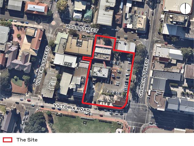
Figure 1 – Site at 355 and 375 Church Street, Parramatta subject to the planning proposal
Under the Parramatta Local Environmental Plan 2011 the site:
· is zoned B4 mixed use;
· has a maximum building height of 24 metres (northern and western part of the site) and 34 metres (south-eastern corner of the site);
· has a maximum floor space ratio (FSR) of part 3:1 and part 4:1.
These principal planning controls are to remain unchanged under
this planning proposal. Instead, this planning proposal seeks to introduce a
site-specific local provision in Part 7 of the Parramatta LEP which contains an
incentive height control to be determined by the sun access control to Prince
Alfred Square, an incentive FSR control of 6.9:1, and other provisions.
These amendments are sought with the intention of providing a mixed-use
residential and commercial tower complex at the site. An indicative development
concept has been prepared to test the opportunities for built form within the
envelopes sought, consisting of a 31-storey mixed-use building that is
inclusive of a three (3) to four (4) storey podium and two (2) towers (31 and
28 storeys) over a single basement level for car parking. An indicative concept
is shown in Figure 2 below.
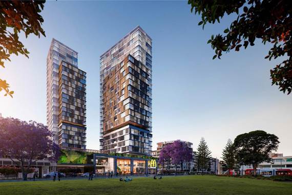
Figure 2 – Indicative design concept
This Planning Proposal is a result of the findings of the Parramatta CBD Planning Strategy (2015) and Parramatta CBD Planning Proposal (2016), both of which identify the site as being suitable for increased density to support the future growth of Parramatta CBD. This Planning Proposal seeks to amend core development standards within the LEP in accordance with the development standards Council has already recommended for the site. The purpose of this standalone Planning Proposal is to facilitate an indicative development concept that would deliver a project in keeping with the vision set in the Parramatta CBD Planning Proposal.
In 2015, the applicant (McDonald’s) submitted a previous Development Application (DA96/2015A) for a staged development of the site involving the demolition of existing structures, consolidation and subdivision to create 2 Torrens title allotments, construction of a McDonald’s restaurant on proposed Lot A (Stage 1) and concept approval for a future mixed-use development over basement parking on proposed Lot B (Stage 2). This application was deferred by the Sydney West Joint Regional Planning Panel (JRPP), with the Panel recommending that an amended proposal be developed that responds to design issues identified. McDonald's and Stockland (the applicant) have subsequently committed to renew the site into a mixed-use precinct and this Planning Proposal will facilitate changes to the LEP that will enable this key site to be redeveloped, in keeping with the Panel’s comments from this previous DA.
PART 1 – OBJECTIVES OR INTENDED OUTCOMES
The key objective of this planning proposal is to increase the permissible density of development at 355 and 375 Church Street, Parramatta, whilst minimising amenity impacts on surrounding sites.
The intended outcomes of this planning proposal are as follows:
· Deliver controls and a built form outcome which is generally consistent with the Parramatta CBD Planning Proposal
· Achieve design excellence on a strategic CBD site
· Protect solar access to Prince Alfred Square
· Ensure a podium design that is compatible to the existing streetscape and which provides attractive active frontages to Victoria Road and Church Street
· Facilitate higher density residential development on a strategic site in immediate proximity of the future light rail, building on the principles of transit-oriented development
PART 2 – EXPLANATION OF PROVISIONS
This planning proposal seeks to amend Parramatta LEP 2011 (PLEP 2011) in relation to introducing site-specific local provisions for an incentive height of building and floor space ratio control at 355 and 375 Church Street, Parramatta (the site).
In order to achieve these desired objectives, the following amendments to the PLEP 2011 would need to be made:
1. Introduce an incentive height control with maximum height determined by the sun access plane to Prince Alfred Square in accordance with a site-specific local provision, and in a manner consistent with the Parramatta CBD Planning Proposal. The existing Height of Buildings Map is to remain unchanged, while the Sun Access Protection Map would be altered to introduce designation of the portion of Prince Alfred Square which is subject to sun access protection.
2. Introduce an incentive FSR control of 6.9:1 in accordance with a site-specific local provision, and in a manner consistent with the Parramatta CBD Planning Proposal. The existing Floor Space Ratio map is to remain unchanged.
3. Introduce a site-specific local provision in Part 7 to facilitate the above height and FSR controls, as well as introduce site-specific maximum car parking rates for residential uses, commercial uses, and Take Away Food and Drink Premises uses as outlined in the example clause below:
7.XX Development on land at 355 and 375 Church Street, Parramatta
1. This clause applies to land marked “Area #xx” on the Special Provisions Area Map.
2. Despite any other provision of this Plan, the consent authority may grant consent to the erection of a building on land to which this clause applies that has a floor space ratio that exceeds the maximum floor space ratio shown for the land on the Floor Space Ratio Map, up to a maximum floor space ratio of 6.9:1, but only if the consent authority is satisfied that the development has been subject to a competitive design process and exhibits design excellence as provided in clause 7.10.
3. Despite any other provision of this Plan, the consent authority may grant consent to the erection of a building on land to which this clause applies that has a height that exceeds the maximum height of a building shown for the land on the Height of Buildings Map, but only if the consent authority is satisfied that the development does not result in any additional overshadowing on the land shown with blue hatching as ‘Prince Alfred Square’ on the Sun Access Protection Map – between 12 noon and 2pm on 21 June in each year.
4. Despite any other provisions of this Plan, the maximum number of car parking spaces for residential accommodation in a building on land to which this clause applies is as follows—
(a) 0.1 space per studio apartment,
(b) 0.3 space per 1 bedroom apartment,
(c) 0.7 space per 2 bedroom apartment,
(d) 1 space per 3 bedroom apartment.
5. Despite any other provisions of this Plan, the maximum number of car parking spaces for non-residential premises in a building on land to which this clause applies is to be calculated using the following formula (but only if the building has a floor space ratio greater than 3.5:1)—M = (G X A) / (50 x T)
where—
M is the maximum number of parking spaces.
G is the gross floor area of all non-residential premises (excluding any gross floor area used for the purposes of Take Away Food and Drink Premises**) in the building in square metres.
A is the site area in square metres.
T is the total gross floor area of all buildings on the site in square metres.
6. Despite any other provisions of this Plan, the maximum number of car parking spaces for Take Away Food and Drink Premises in a building on land to which this clause applies is as follows:
1 parking space / 30 sqm of gross floor area of all Take Away Food and Drink Premises, or a maximum of 30 parking spaces, whichever is less**
*Note: the parking rate described above for Take Away Food and Drink Premises will also have a “sunset” clause which will end the application of this provision after 5 years from the date of notification of the amendment. This would also require a change to the provision above containing the formula for calculating parking spaces for other non-residential uses, in order to include the Take Away Food and Drink Premise use into the calculation under that formula.
1.1. Other relevant matters
1.1.1. Voluntary Planning Agreement
The Applicant has indicated willingness to negotiate a Voluntary Planning Agreement (VPA) alongside this Planning Proposal. This matter is discussed in further detail in the pre-Gateway reports to Local Planning Panel and Council.
A site-specific DCP will accompany the PP process, and the parameters for commencing this process are set out in the pre-Gateway reports to Local Planning Panel and Council.
This part describes the reasons for the proposed outcomes and development standards in the planning proposal.
3.1 Section A - Need for the planning proposal
3. This section establishes the need for a
planning proposal in achieving the key outcome and objectives. The set
questions address the strategic origins of the proposal and whether amending
the LEP is the best mechanism to achieve the aims on the proposal.
3.1.1. Is the planning proposal a result of an endorsed local strategic planning statement, strategic study or report?
Yes. The primary outcome of this Planning Proposal, to enable a higher density of development and mix of residential and commercial land uses, stems from local and state government strategic plans including the NSW Government’s ‘A Metropolis of Three Cities – Greater Sydney Regional Plan’ (the Regional Plan) and the Parramatta CBD Planning Strategy. The proposal’s consistency and alignment to these two strategies, is outlined later in this section of the report.
Council adopted the Parramatta CBD Planning Strategy at its meeting on 27 April 2015. The Strategy is the outcome of a study which reviewed the current planning framework and also a significant program of consultation with stakeholders and the community. The Strategy sets the vision for the growth of the Parramatta CBD. Council has subsequently prepared a CBD-wide Planning Proposal which has been informed by workshops and Council resolutions.
The Parramatta CBD Planning Proposal was adopted by Council on 11 April 2016. It has been submitted to the NSW Department of Planning and Environment, and has received a Gateway determination.
3.1.2. Is the Planning Proposal the best means of achieving the objectives or intended outcomes, or is there a better way?
Yes. A Planning Proposal seeking to amend the LEP is the most effective way of providing certainty for Council, the local community and the landowner. The existing height and FSR standards do not permit the development envisaged in this Planning Proposal, nor do they respond to the emerging CBD character of Parramatta.
3.2. Section B – Relationship to strategic planning framework
This section assesses the relevance of
the Planning Proposal to the directions outlined in key strategic planning
policy documents. Questions in this section consider state and local government
plans including the Greater Sydney Commission’s Greater Sydney Region
Plan and District Plans, State Environmental Planning Policies, local
strategic and community plans and applicable Ministerial Directions.
3.2.1. Will the planning proposal give effect to the objectives and actions of the applicable regional, or district plan or strategy (including any exhibited draft plans or strategies)?
A Metropolis of Three Cities
In March 2018, the NSW Government released the Greater Sydney Region Plan: A Metropolis of Three Cities (“the GSRP”), a 20 year plan which outlines a three-city vision for metropolitan Sydney for to the year 2036.
The GSRP is structured under four themes: Infrastructure and Collaboration, Liveability, Productivity and Sustainability. Within these themes are 10 directions that each contain Potential Indicators and, generally, a suite of objective/s supported by a Strategy or Strategies. Those objectives and or strategies relevant to this planning proposal are discussed below.
Liveability
An assessment of the planning proposal’s consistency with the GSRP’s relevant Liveability objectives is provided in Table 3a, below.
Table 3a – Consistency of planning proposal with relevant GSRP Actions – Liveability
|
Liveability Direction |
Relevant Objective |
Comment |
|
Housing the city
|
O10: Greater housing supply |
The planning proposal will meet contribute to delivering housing targets in the Central District and facilitate the Greater Parramatta Growth area. Consistent with the objective it will link the delivery of new homes in the right locations with local infrastructure evidenced by the proximity of the proposal to the Parramatta Light Rail. |
|
|
O11: Housing is more diverse and affordable |
The planning proposal will facilitate a diversity of housing types, sizes and price points that can help improve affordability. It will increase the supply of housing that is of universal design and adaptable to people’s changing needs as they age which is increasingly important across Greater Sydney. |
Productivity
An assessment of the planning proposal’s consistency with the GSRP’s relevant Productivity objectives is provided in Table 3b, below.
Table 3b – Consistency of planning proposal with relevant GSRP Actions – Productivity
|
Productivity Direction |
Relevant Objective |
Comment |
|
A well connected city |
O14: The plan integrates land use and transport creates walkable and 30 minute cities |
The planning proposal will attract housing in the Parramatta Metropolitan centre to create walkable, cycle-friendly neighbourhoods. Specifically, the site is in the Parramatta CBD and therefore provides future residents with excellence access to jobs and services, well below 30 minutes. |
|
O15: The Eastern, GPOP and Western Economic Corridors are better connected and more competitive |
The planning proposal is consistent with this objective and will contribute to delivery of the Greater Parramatta and Olympic Peninsula (GPOP) vision. It is consistent with Parramatta Light Rail by locating new housing and business opportunities in the GPOP area. |
|
|
Jobs and skills for the city |
O22: Investment and business activity in centres |
The planning proposal will create the conditions for residential development within the Parramatta strategic centre within walking distance of the CBD core. |
Central City District Plan
In March 2018, the NSW Government released Central City District Plan which outlines a 20 year plan for the Central City District which comprises The Hills, Blacktown, Cumberland and Parramatta local government areas.
Taking its lead from the GSRP, the Central City District Plan (“CCDP”) is also structured under four themes relating to Infrastructure and Collaboration, Liveability, Productivity and Sustainability. Within these themes are Planning Priorities that are each supported by corresponding Actions. Those Planning Priorities and Actions relevant to this planning proposal are discussed below.
Liveability
An assessment of the planning proposal’s consistency with the CCDP’s relevant Liveability Priorities and Actions is provided in Table 4a, below.
Table 4a – Consistency of planning proposal with relevant CCDP Actions – Liveability
|
Liveability Direction |
Planning Priority/Action |
Comment |
|
Housing the city O10: Greater housing supply O11: Housing is more diverse and affordable
|
PP C5: Providing housing supply, choice and affordability, with access to jobs, services and public transport · A16: Prepare local or district housing strategies that address housing targets [abridged version] |
The
planning proposal is consistent with the Planning Priority and actions by
facilitating new housing supply and choice which will put downward pressure
on affordability. The site is in a key location that will be close to jobs,
service and public transport. |
|
A city of great places O12: Great places that bring people together O13: Environmental heritage is identified, conserved and enhanced |
PP C6: Creating and renewing great places and local centres, and respecting the District’s heritage · A18: Using a place-based and collaborative approach throughout planning, design, development and management deliver great places by (a-e) · A20: Use place-based planning to support the role of centres as a focus for connected neighbourhoods · A21: In Collaboration Areas, Planned Precincts and planning for centres (a-d) · A22: Use flexible and innovative approaches to revitalise high streets in decline. |
The
planning proposal will renewal of a strategic site in Parramatta CBD. It will
enable revitalisation of the locality that will be activated by high quality
spaces that will engage with the community.
|
Productivity
An assessment of the planning proposal’s consistency with the CCDP’s relevant Productivity Priorities and Actions is provided in Table 4b, below.
Table 4b – Consistency of planning proposal with relevant CCDP Actions – Productivity
|
Productivity Direction |
Planning Priority/Action |
Comment |
|
A well-connected city O19: Greater Parramatta is stronger and better connected |
PP C7: Growing a stronger and more competitive Greater Parramatta · A23: Strengthen the economic competitiveness of Greater Parramatta and grow its vibrancy [abridged] |
The planning proposal is consistent with the CBD PP and will contribute to a stronger and more competitive Parramatta by facilitating a high-quality development in a key strategic location. |
|
O14: The plan integrates land use and transport creates walkable and 30 minute cities |
PP C9: Delivering integrated land use and transport planning and a 30-minute city · A32: Integrate land use and transport plans to deliver a 30-minute city |
The planning proposal will facilitate housing and jobs in a location close to public transport, consistent with the principles of the 30-minute city. |
NSW State Plan 2021
The New South Wales State Plan sets the strategic direction and goals for the NSW Government across a broad range of services and infrastructure. The planning proposal is consistent with the revised NSW State Plan 2021 in that it will:
- Create construction jobs
- Contribute to housing supply
- Encourage business investment in the Parramatta City Centre
- Develop a high-quality development in proximity to new infrastructure delivered by the NSW Government, including the Parramatta Light Rail Network.
Future Transport Strategy 2056
The Future Transport Strategy is a 40-year strategy to achieve the Government’s vision for the city’s transport system. The planning proposal is consistent with the Strategy by:
- Integrating land use and transport by increasing density directly adjacent to the future Parramatta Light Rail line on Church Street
- Improving liveability by providing housing and jobs close to high quality, reliable public transport
- Improving sustainability by locating jobs and homes close to public transport which will reduce reliance on private motor vehicles and encourages active transport.
3.2.1. Will the planning proposal give effect to a council’s endorsed local strategic planning statement, or another endorsed local strategy or strategic plan?
The following local strategic planning documents are relevant to the planning proposal.
Parramatta 2038 Community Strategic Plan
Parramatta 2038 is a long term Community Strategic Plan for the City of Parramatta and it links to the long-term future of Sydney. The plan formalises several big and transformational ideas for the City and the region.
This planning proposal is consistent with the strategies and key objectives identified in the Plan, including its central vision for “a successful and connected CBD with a thriving commercial heart”, by facilitating the provision of a higher density development at 355 and 375 Church Street that exhibits design excellence. It is consistent with the identified strategic objectives of ‘Environment’, ‘Connectivity’, and ‘People and Neighbourhoods’, with the indicative development scheme at the site to increase energy and water efficiency, increase walking/cycling/public transportation usage, and improve housing affordability and diversity.
Parramatta Local Strategic Planning Statement
The Parramatta Local Strategic Planning Statement (LSPS) entered into effect on 31 March 2020, becoming the primary strategic planning document defining Council’s long-term vision for land use and infrastructure provision within the LGA and giving guidance to its future character. Local Strategic Planning Statements are statutory requirements under the EP&A Act (updated at least every seven years), giving effect to the Greater Sydney Region Plan, Eastern City District Plan and other strategies such as Future Transport 2056 and the State Infrastructure Strategy.
The LSPS is a formal matter for consideration for any future rezoning of sites within the LGA. The LSPS will also inform the future revision of Council’s LEP and DCP controls. This planning proposal is consistent with the relevant Planning Priorities of the finalised LSPS, including that of the following:
• Expand Parramatta’s economic role as the Central City of Greater Sydney
• Focus housing and employment growth in the GPOP and Strategic Centres
• Provide for a diversity of housing types and sizes to meet community needs into the future
• Build the capacity of the Parramatta CBD, Strategic Centres, and Employment Lands to be strong, competitive and productive
Parramatta Local Housing Strategy
The Draft Parramatta Local Housing Strategy was exhibited in conjunction with Council’s Local Strategic Planning Statement and Community Infrastructure Strategy for six weeks from September to November 2019. It is anticipated to be considered by Council in mid-2020.
The planning proposal is consistent with the overarching aims and objectives of the Draft Local Housing Strategy, including that of the following:
• Housing delivery complements, not compromises, the economic significance of the City
• Additional housing is focussed in identified growth precincts and is aligned and sequenced with existing transport and capacity improvements
• Housing supports the key essential services in the City through striving for housing affordability.
The draft Local Housing Strategy, in addition to the Central City District Plan, identifies the need for 83,975 new dwellings to be constructed within the LGA between the years of 2016 and 2036. The indicative development concept of this planning proposal will contribute towards meeting this target, by providing an additional 346 apartments.
Parramatta CBD Planning Strategy
The vision and objectives in the Parramatta CBD Planning Strategy were prepared to reflect Council’s vision for how the objectives in A Plan for Growing Sydney will be achieved in the Parramatta CBD. This planning proposal is consistent with the principles of the Parramatta CBD Planning Strategy as it will:
- Integrate appropriate land use, density and transport at a strategically important site
- Contribute toward the additional 27,000 additional jobs and 7,500 additional dwellings identified
- Provide financial contribution toward community infrastructure
- Provide value uplift sharing as a result of the incentive floor space
- Enable delivery of a built form outcome that can achieve design excellence and slender tower forms
- Renew an underutilised site in a key location that will improve the public domain.
Parramatta CBD Planning Proposal
The City of Parramatta has expressed clear ambitions to provide for an expanded and more intense commercial core and to support the CBD as a vibrant centre by surrounding the core with higher density mixed use. The commissioning of the Parramatta CBD Planning Strategy lead to the establishment of a vision for growth, including principles and actions to guide a new planning framework and an implementation plan for delivery. This Planning Strategy has been translated into the Parramatta CBD Planning Proposal, against which this planning proposal is generally consistent.
Parramatta Draft Social Infrastructure Strategy
The Parramatta Draft Social Infrastructure Strategy outlines the City of Parramatta Council’s long-term direction for social infrastructure provision. Once finalised, it will be used by Council to identify priorities for future social infrastructure, direct sound decision making about planning, funding, delivering and negotiating for social infrastructure.
This planning proposal includes a local provision that enables the site to achieve incentive floor space where community infrastructure is provided or is contributed toward. The incentive FSR control is to enable some of the financial value resulting from the uplift to the residential floor space ratio of a site to be captured for the benefit of the community.
A Voluntary Planning Agreement is proposed that would provide a financial contribution toward community infrastructure that may include Prince Alfred Square, as identified by the Draft Social Infrastructure Strategy.
Notwithstanding the above, the Strategy outlines ways in which social infrastructure can be integrated within development. The indicative development concept has considered how the McDonalds drive-through could be adapted in the future where it is no longer required, as a way to respond to community requirements in the future.
Parramatta Priority Growth Area Interim Land Use and Infrastructure Implementation Plan
The planning proposal is consistent with the Greater Parramatta Priority Growth Area Interim Land Use and Infrastructure Implementation Plan as it will:
- Contribute to the additional 20,297 housing and 48,763 jobs forecast for the Parramatta CBD District
- Locate new housing and jobs in an urban renewal area that takes advantage of the opportunities the new Parramatta Light Rail will provide
- Provide financial contributions through value uplift sharing that will contribute toward Council infrastructure needs
3.2.2. Is the planning proposal consistent with the applicable State Environmental Planning Policies?
The following State Environmental Planning Policies (SEPPs) are of relevance to the site (refer to Table 5 below).
Table 5 – Consistency of planning proposal with relevant SEPPs
|
State Environmental Planning Policies (SEPPs) |
Consistency: Yes = ✓ No = x N/A = Not applicable |
Comment |
|
SEPP No 1 Development Standards |
N/A |
This SEPP is not applicable to the subject land under Clause 1.9 of the Parramatta LEP 2011. |
|
SEPP 4 – Development Without Consent and Miscellaneous Exempt and Complying Development |
N/A |
Not relevant to proposed LEP amendment |
|
SEPP 6 – Number of Storeys in a Building |
N/A |
Not relevant to proposed LEP amendment |
|
SEPP 33 – Hazardous and Offensive Development |
N/A |
Not relevant to proposed LEP amendment |
|
SEPP No 55 Remediation of Land
|
✓ |
Not relevant to proposed LEP amendment. May apply to future development on the sites. |
|
SEPP 60 – Exempt and Complying Development |
N/A |
Not relevant to proposed LEP amendment |
|
SEPP 64 – Advertising and Signage |
N/A |
Not relevant to proposed LEP amendment |
|
SEPP No 65 Design Quality of Residential Flat Development
|
✓ |
Nothing within this amendment will prevent a future DA’s ability to comply with SEPP 65. |
|
SEPP No.70 Affordable Housing (Revised Schemes) |
N/A |
Not relevant to proposed LEP amendment |
|
SEPP (Affordable Rental Housing) 2009 |
N/A |
Not relevant to proposed LEP amendment |
|
SEPP (BASIX) 2004 |
✓ |
Not relevant to proposed LEP amendment. May apply to future development on the sites. |
|
SEPP (Exempt and Complying Development Codes) 2008 |
N/A |
Not relevant to proposed LEP amendment |
|
SEPP (Infrastructure) 2007 |
✓ |
Not relevant to proposed LEP amendment. May apply to future development on the sites. |
|
Sydney Regional Environmental Plan No 18–Public Transport Corridors |
N/A |
This SEPP is not applicable to the subject land under Clause 1.9 of the Parramatta LEP 2011. |
|
Sydney Regional Environmental Plan (Sydney Harbour Catchment) 2005
|
N/A
|
Not relevant to proposed LEP amendment |
|
SEPP (Urban Renewal) 2010 |
✓ |
The Planning Proposal will stimulate renewal within Parramatta and will contribute to the employment and job targets for the area. |
3.2.3. Is the planning proposal consistent with applicable Ministerial Directions (s.9.1 directions)
In accordance with Clause 9.1 of the EP&A Act 1979 the Minister issues directions for the relevant planning authorities to follow when preparing planning proposals for new LEPs. The directions are listed under the following categories:
· Employment and resources
· Environment and heritage
· Housing, infrastructure and urban development
· Hazard and risk
· Local plan making
· Metropolitan planning
The following directions are considered relevant to the subject Planning Proposal.
Table 6 – Consistency of planning proposal with relevant Section 9.1 Directions
|
Relevant Direction |
Comment |
Compliance |
|
1. Employment and Resources |
||
|
Direction 1.1 – Business and Industrial Zones
|
While the planning proposal does not seek to amend the B4 Mixed Use zoning, the planning proposal will facilitate a mixed-use development consistent with this direction in that it retains a zoning that permits all types of commercial premises with consent.
|
Yes |
|
3. Housing, Infrastructure and Urban Development |
||
|
Direction 3.1 - Residential Zones
|
The planning proposal is consistent with the objectives of this direction as it will increase residential densities and housing choice in a location that is close to public transport, shops, employment and recreational opportunities. |
Yes |
|
Direction 3.4 - Integrating Land Use and Transport
|
This Direction applies due to this planning proposal relating to a residential zone. The Direction states that a planning proposal must be consistent with the aims, objectives and principles of: · Improving Transport Choice – Guidelines for planning and development (DUAP 2001), and · The Right Place for Business and Services – Planning Policy (DUAP 2001). The planning proposal is broadly consistent with the aims, objectives and principles of the above documents in that it will provide residential accommodation in an area well serviced by public transport. |
Yes |
|
Direction 3.5 - Development Near Licensed Aerodromes |
Bankstown
Airport is subject to the federal Airports Act 1996 and the Airports (Protection
of Airspace) Regulations 1996. |
Yes |
|
4. Hazard and Risk |
||
|
Direction 4.1 - Acid Sulfate Soils |
Parramatta LEP 2011 contains acid sulphate soils provisions and this proposal does not seek to amend them. Acid sulphate soils investigations and analysis will accordingly be undertaken as part of any future development of the land in accordance with the requirements of the LEP. |
Yes |
|
Direction 4.3 - Flood Prone Land |
A draft
LEP may be inconsistent with the requirements of this direction if it
“is in accordance with a floodplain risk management plan prepared in
accordance with the principles and guidelines of the Floodplain Development
Manual 2005.” |
Yes |
|
5. Local Plan Making |
||
|
Direction 6.1 – Approval and Referral Requirements |
This planning proposal is consistent with this Direction in that it does not introduce any provisions that require any additional concurrence, consultation or referral. |
Yes |
|
Direction 6.2 – Reserving Land for Public Purposes |
This planning proposal is consistent with this Direction in that it does not create, alter or reduce existing zonings or reservations of land for public purposes. |
Yes |
|
Direction 6.3 – Site Specific Provision |
Site specific amendments to the LEP are sought, however, these are consistent with the proposed provisions of the CBD PP. |
Yes |
|
6. Metropolitan Planning |
||
|
Direction 7.1 - Implementation of A Plan for Growing Sydney |
The planning proposal is consistent with the Metropolitan Plan, as discussed in above. |
Yes |
|
Direction 7.5 – Implementation of Greater Parramatta Priority Growth Area Interim Land Use and Infrastructure Implementation Plan |
The planning proposal is consistent with the Interim Plan. |
Yes |
3.3. Section C – Environmental, social and economic impact
This section considers the potential
environmental, social and economic impacts which may result from the Planning
Proposal.
3.3.1. Is there any likelihood that critical habitat or threatened species, populations or ecological communities, or their habitats, will be adversely affected as a result of the proposal?
The site is located within a highly modified urban environment and does not contain critical habitat or threatened species, populations or ecological communities, or their habitats.
3.3.2. Are there any other likely environmental effects as a result of the planning proposal and how are they proposed to be managed?
Density
The FSR sought under this Planning Proposal (6:1 FSR + 15% Design Excellence bonus, bringing total FSR to 6.9:1) is consistent with the provisions for this site under the Parramatta CBD Planning Proposal.
Height and Sun Access Plane (SAP) to Prince Alfred Square
Under the Parramatta CBD Planning Proposal, the height controls for this site are determined by the Prince Alfred Square Sun Access Plane (SAP). The SAP ensures that no additional overshadowing is created on the southern part of the Square between 12pm-2pm in midwinter (21 June). Figures 3 and 4 illustrate the protected portion of the park, and the impact that this control has on the potential building envelope for this site.
Figure 3: Portion of Prince Alfred Square protected by SAP (blue hatching)
Source: Draft Parramatta CBD Planning Proposal (as at time of report writing)
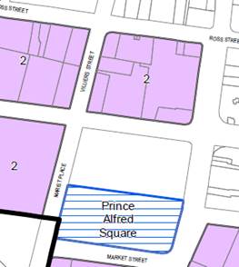
Figure 4: Prince Alfred Square SAP and resulting building envelope on subject site
Source: Applicant’s reference design

The Planning Proposal aligns with the desired outcomes of the Parramatta CBD Planning Proposal on this issue, as it seeks to replicate the Prince Alfred Square SAP in its provisions and presents a preferred scheme that is compliant with this SAP (as discussed in the following section).
Urban design and built form
In preparing the indicative concept design that supports this Planning Proposal, a number of options were considered to facilitate the intended outcomes outlined at Section 5.1, including:
- Option 1: A single tower scheme
- Option 2: A two tower scheme (the Planning Proposal)
- Option 3: Retain existing controls
- Option 4: Await gazettal of the CBD PP
Option 1: Single tower scheme
Under a single tower scheme, the resultant tower would include a 1,000m2 floorplate to a height of 146m or 45 levels. The single tower would present a dominant ‘monolith’ that would not frame the surrounding space and would not relate well to Prince Alfred Square or the local context. This Planning Proposal therefore seeks controls that facilitate an alternative design that maintains a similar yield and protects shadowing of the park through delivery of two slender and shorter towers on the site.
Option 2: Two tower scheme (this Planning Proposal)
The preferred indicative development concept comprises two towers that are slender and elegant in appearance. The South Tower has a height of 31 storeys with a maximum floorplate of 912m2. The North Tower reaches 28 storeys and has a maximum floorplate of 711m2. Each tower tapers on upper levels reducing overshadowing and minimising building scale. Together the towers frame the space which is considered suitable to the surrounding context and to Prince Alfred Square. This scheme may have some non-compliances with the requirements set out in the Apartment Design Guide.
Option 3: Retain existing controls
The retention of the existing controls under the Parramatta LEP would not facilitate a development commensurate with the strategic nature of the site. As detailed in Council’s CBD Planning Proposal, Council’s position is that the site has the capacity to accommodate a greater height and floor space ratio control than those existing currently.
Option 4: Await gazettal of the Parramatta CBD Planning Proposal
Gazettal of the Parramatta CBD Planning Proposal (in its current form) would result in the same controls applied to the site as proposed in this Planning Proposal. However, due to the complexity associated with the scale of the Parramatta CBD Planning Proposal, the timeframe for its finalisation is currently not known.
Submitting a site-specific Planning Proposal will likely result in a quicker assessment process and therefore, facilitate the development of a high quality mixed-use development on this strategic site quicker than awaiting gazettal of the Parramatta CBD Planning Proposal. It also enables certainty about the LEP outcome, enabling the progression of a site-specific DCP for this site.
A comparison of Options 1 and 2 is included in the Design Report appended to this Planning Proposal.
Despite the potential non-compliances of a two-tower scheme with the Apartment Design Guide, the scale of the towers and podium in the two-tower scheme is considered more sensitive to the local context, which includes Church Street, Heritage-listed Prince Alfred Square, and other nearby Heritage items. The scale of the podium of the two-tower scheme is more appropriately matched with that of nearby buildings, and dividing the mass between two towers creates a more appropriate relationship between towers on this site and other likely future development in the vicinity (as envisioned under the Parramatta CBD Planning Proposal).
Heritage
A Heritage Impact Statement is appended to this Planning Proposal.
The proposal is consistent with the Parramatta CBD Planning Proposal, which has given extensive consideration to Heritage matters. Given the proximity to Prince Alfred Square, a preliminary referral to the Office of Environment and Heritage was also undertaken. OEH’s preliminary comments and a response from Council officers is detailed in the table below.
|
OEH Preliminary Comment |
Council Officer Response |
|
“The HIS has concentrated on the potential impact of the proposed development on views to and from the heritage items, more consideration needs to be given to assessing the impact of the proposal on the setting of heritage items in the immediate vicinity. Photomontages demonstrating the relationship between the new element and heritage items in the immediate vicinity should be provided in an updated HIS. The updated HIS should clearly articulate mitigation strategies recommended to reduce or avoid adverse impact on heritage items. Appropriate setbacks for the tower elements should be considered in the HIS. The proposed development should not overwhelm the neighbouring park or dominate vistas along Victoria Road.”
“[the HIS] ... discusses views to and from heritage items in the vicinity however the images provided to not show a representation of proposed to development. Photomontages would assist in the assessment of the potential impact on views to and from these items. An updated HIS should included photomontages showing the extent to which the proposed development can be seen in identified views. Representations of the proposed structures should be solid (not semi-transparent).” |
The Planning Proposal is consistent with the CBD Planning Proposal, the formulation of which has taken into account impacts on heritage items.
The HIS originally submitted by the applicant has been updated to include a diagrammatic cross-section showing the relationship between the reference design’s podium and St. Patrick’s Cathedral.
The Planning Proposal considers changes to planning controls with a potential reference design envelope only (i.e. it does not consider detailed proposed development). Therefore, Council officers consider that a more detailed examination of impacts on heritage items (including issues such as setbacks, relationship to Prince Alfred Square, vistas, views etc.) and mitigation strategies should form part of later stages of this project, (including DCP, design competition and DA) when the specific nature of the proposed development is known. Officers also consider that photomontages are more appropriately included at those later stages of development (again, when the specific nature of the proposed development is known).
|
|
“Documentation accompanying the proposal indicates that large part of Prince Alfred Park will be overshadowed in winter as a result of the proposed development. This may impact on the use of this historic park and on its plantings. The concept design should seek to mitigate or avoid this impact. An updated HIS should address the impact of the overshadowing of the park on the significance of this item.” |
The Planning Proposal complies with the Prince Alfred Square SAP, which seeks to protect the Southern half of Prince Alfred Square.
The Planning Proposal is considering changes to planning controls with a potential reference design envelope only (i.e. it does not consider detailed proposed development). Therefore, officers consider that further mitigation of the impacts on Prince Alfred Square should be investigated at later stages (including DCP, design competition and DA) when the specific nature of the proposed development is known. |
|
“The podium elevation should be appropriately articulated on its street frontages to avoid the creation of a ‘wall effect’ along the length of the site.” |
Officers consider that podium articulation is a design issue best addressed through the DCP and design competition stages. Nevertheless, the applicant has added further consideration of the podium’s relationship to nearby Heritage Items to the amended HIS; this discussion suggests a green interface with landscaping elements on the podium to break up the podium element and extend the green space established by Prince Alfred Square. |
|
“The Australian Government, the NSW Government and Parramatta City Council have signed a Conservation Agreement under the Environmental Protection and Biodiversity Conservation Act 1999 to protect the world and National Heritage values of Old Government House and Domain (OGHD) in relation to its significant views and settings. The Agreement requires that the findings of the Technical Report (Planisphere 2012) be implemented. Council should satisfy themselves that the requirements of the Conservation Agreement have been met.”
“The HIS identifies that the proposed development is within the ‘sensitive’ zone for views from Old Government House and Domain. The Technical Report includes design requirements that proposed development should address. An updated HIS should demonstrate how the proposed development meets these requirements.” |
The outcome of the analysis and discussions between Council and the State, Federal Agencies when formulating the Conservation Agreement described by OEH is that only the sites in the Area of Special Significance (a precinct located south west of the subject site) would be subject of the agreement. Outside this precinct Council could continue to plan to allow growth in other parts of the Parramatta CBD without having to refer the changes to the Federal Government under the Environmental Protection and Biodiversity Conservation Act 1999. The Area of Special Significance is the most significant precinct when it comes to the world and National Heritage values of Old Government House and Domain (OGHD).
The impacts of growth outside the Area of Special Significance were considered in the Heritage Study prepared by Urbis (2015) undertaken as part of the Parramatta CBD Planning Proposal. The conclusion of this study was that the growth proposed in the Parramatta CBD Planning Proposal does not have any significant impact on the world and National Heritage values of Old Government House and Domain (OGHD).
The Planning Proposal does not propose development; it proposes to change planning controls consistent with the Parramatta CBD Planning Proposal. One of the factors considered in preparation of the Parramatta CBD Planning Proposal were the various planning requirements relating to OGHD. |
|
“An archaeological assessment may be required. Depending on the recommendations of the assessment further archaeological investigation maybe recommended prior to commencement of works. It is desirable that intact State significant archaeology be retained in situ.” |
Broadly, the Planning Proposal does not change the potential archaeological impacts in comparison to the current planning controls for this site, as this site already has significant development potential under current controls. The Planning Proposal is seeking to allow more height and floorspace on the site. The site would be subject to archaeological assessment at DA stage, whether developed under current planning controls or the controls envisiged by the Planning Proposal. Therefore, it is not considered that an archaeological assessment is required at Planning Proposal stage. Consistent with officers’ approach to other similar site-specific Planning Proposals in the Parramatta CBD, officers recommend that archaeological matters are dealt with at DA stage. |
It is acknowledged that some of the extra work requested by OEH was not completed at this initial stage of the Planning Proposal process, as described in the above table. It is expected that OEH will have the opportunity to provide a formal comment as part of the exhibition process for this Planning Proposal.
Flooding
A portion of the site is within the area of the Probable Maximum Flood (PMF) – refer below image. However, the site is not affected by the 100-year Average Recurrence Interval (ARI) flood area (i.e the “1%” flood zone). It is considered that river flooding is not an impediment to progression of this Planning Proposal, and that any overland flow issues can be addressed as part of a future DA process.
Figure xx: portion of site affected by PMF (denoted with light blue shading)
Source: Council’s internal mapping (subject site outlined in red)

Interface with Parramatta Light Rail
It is not considered that Parramatta Light Rail shoud impede the progression of this Planning Proposal. A preliminary referral to Transport for NSW (TfNSW) was undertaken as part of the initial assessment by Council. The comments made by TFNSW which were relevant to the Planning Stage and a response from Council officers is below. It is anticipated that a further formal referral will be made to TFNSW as part of the exhibition of this Planning Proposal.
|
TfNSW Preliminary Comment |
Council Officer Response |
|
“A Traffic Impact Assessment should consider the existing and future performance of key intersections providing access to the site, supported by appropriate modelling and analysis to the satisfaction of RMS and TfNSW. The TIA should include proposed measures to mitigate impacts of the proposed development on the operation of existing and future traffic, public transport, pedestrian and bicycle networks including any required upgrades.” |
The Applicant has submitted a traffic assessment that examines existing and future performance of key intersections. TfNSW will have the opportunity to comment formally on this assessment as part of agency referral and can identify any additional measures required for the satisfaction of transport agencies through that process. |
|
“The TIA should include an assessment of any impacts of the development on the Parramatta Light Rail (PLR). During the construction and operation phases of the Parramatta Light Rail (PLR) there will be intermittent, short and long term road closures as well as material changes to road network operations. These changes may impact pedestrian, cyclist and vehicular access routes to the proposed development and should be included in any analysis.” |
Council officers agreed with TfNSW’s view that the Applicant should review the PLR Environmental Impact Statement (EIS) and related documents in greater detail, and consider these in an amended traffic assessment. This review has been undertaken and the Applicant’s traffic assessment has been updated to include changes to the road network as a result of the PLR (in particular the changes to the intersection of Victoria Road and Church St). |
Traffic and Access Issues
The reference design envisages dual vehicle access from both Victoria Road (entry) and Ross Street (entry and exit), with retention of a drive-through facility located within the podium. The drive-through is integrated into the basement design and sleeved by lobbies and commercial/retail uses.
The traffic report (appended to this Planning Proposal) concludes that the reference design will result in a reduction of traffic during peak periods.
The Planning Proposal applicant has acknowledged that the right turn entry from Victoria Rd may be limited in future.
The reference design demonstrates consideration of future adaptive re-use of the drive-through facility, should it no longer be commercially desirable in future.
Parking Issues
The rates for residential and commercial (excluding Take Away Food and Drink Premises) are consistent with the Parramatta CBD Planning Proposal.
The Planning Proposal proposes establishing a specific parking rate for the Take Away Food and Drink Premises. This parking rate is supported on the following basis:
a. There is a shared vision for this site, which is to see it redeveloped in line with the Parramatta CBD Planning Proposal (with which the proposal is otherwise consistent);
b. Feasibility pressures are acknowledged, i.e. the blanket commercial parking rate formula otherwise applied in the Parramatta CBD Planning Proposal would make this development unviable in the short term. It is considered that car parking vs. active transport is one of many “transitional” issues facing the City as it assumes the role of Sydney’s Central City over the coming years. In other words, the viability of this development as proposed at present remains dependent on vehicle traffic. However, it is considered that the business model for this and many other vehicle-dependent businesses will necessarily rebalance toward active transport in coming years as (a) new public transport infrastructure comes on line and (b) a mix of public and active transport modes become the most viable transport option in to, out of and around the Parramatta CBD (given the significant increases in development).
c. The proposed rate results in a decrease of approximately 50% in on-site parking associated with this use, and the traffic report states that the net result of the development will be a reduction in vehicle traffic during the peak.
d. The Design Report includes conceptual work demonstrating how the drive through could be adapted to other uses in the future, and it is considered that this work could be extended to include at least some of the proposed parking.
e. Appropriate limits can be applied to the proposed rate at clause drafting stage, as follows:
i. Structuring the control to limit the parking to 1 space / 30 sqm or 30 spaces, whichever is less. This ensures that the number of spaces is capped at the 30 spaces, even if the size of the use increases at DA stage. It will also scale down the number of spaces if the size of the restaurant ends up being smaller than currently anticipated.
j. Placing a 5-year “sunset” clause on this parking rate, after which time the control would revert to the blanket commercial rate applied to the rest of the commercial uses through the Parramatta CBD Planning Proposal process. This ensures that, should the Applicant not gain planning permission for development within 5 years of finalising this LEP amendment, the parking question would be reconsidered. During that time, it is anticipated that Council will have established a final parking rate regime through the finalisation of the CBD Planning Proposal, and by which time development feasibility calculations may have changed based on transport mode shifts in the CBD.
Isolated Site
The Design Report appended to this Planning Proposal demonstrates how the property at 383 Church St could develop independent of this site in line with the sliding-scale provisions of the Parramatta CBD Planning Proposal.
3.3.3. How has the planning proposal adequately addressed any social and economic effects?
The Planning Proposal will result in positive social and economic effects for the local area through the generation of local employment opportunities during construction and operation. It will improve local facilities, employment opportunities, increase housing stock close to public transport and amenities, provide greater housing choice as well as improve public domain facilities and the pedestrian interface with surrounding streets.
3.4. Section D – State and Commonwealth Interests
3.4.1. Is there adequate public infrastructure for the planning proposal?
The site is located in an established urban area and has access to a range of existing services. Any future DA on the site will include further investigations to determine whether any upgrade of existing facilities will be required. These items would be appropriately addressed at DA stage.
3.4.2. What are the views of State and Commonwealth public authorities consulted in accordance with the gateway determination?
Consultation with the State and Commonwealth public authorities will be undertaken as required by the Gateway determination.
Extracts of current Land Use Zoning, FSR, and Height maps & legends from PLEP 2011 are shown below. No changes are proposed to these maps as part of this Planning Proposal. Following those maps, current and proposed mapping for the Key Sites, Special Provisions, and Sun Access Protection Map is shown.
![]() Land Use Zoning – B4 Mixed Use
Land Use Zoning – B4 Mixed Use
![]()
![]()
![]() FSR – part 3:1,
part 4:1
FSR – part 3:1,
part 4:1
Height – part 24m, part 34m
![]()
![]()
Key Sites, Special Provisions and Sun Access Protection Map
An extract of the current Key Sites, Special Provisions and Sun Access Protection Map of PLEP 2011 and relevant legend is shown below. This is the map which is proposed to be changed as part of this Planning Proposal. As shown below, no specific controls currently apply to the site in question as part of this Planning Proposal.
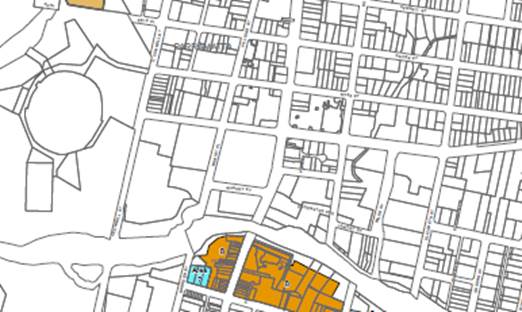
The below image contains indicative mapping for this planning proposal, illustrating what changes are sought. Specifically, this proposal seeks to amend the Key Sites, Special Provisions and Sun Access Protection Map of the PLEP 2011 as shown below. This image can be updated prior to exhibition with a more formal draft LEP map.
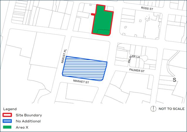
PART 5 – COMMUNITY CONSULTATION
The planning proposal (as revised to comply with the Gateway determination as necessary) is to be publicly available for community consultation.
Public exhibition is likely to include:
· display on the Council’s web-site; and
· written notification to adjoining landowners.
The Gateway determination will specify the level of public consultation that must be undertaken in relation to the planning proposal including those with government agencies.
Consistent with sections 3.34(4) and 3.34(8) of the EP&A Act 1979, where community consultation is required, an instrument cannot be made unless the community has been given an opportunity to make submissions and the submissions have been considered.
Once the planning proposal has been referred to the Minister for review of the Gateway Determination and received a Gateway determination, the anticipated project timeline will be further refined, including at each major milestone throughout the planning proposal’s process.
Table 7 below outlines the anticipated timeframe for the completion of the planning proposal.
Table 7 – Anticipated timeframe to planning proposal process
|
MILESTONE |
ANTICIPATED TIMEFRAME |
|
Report to LPP on the assessment of the PP |
June 2020 |
|
Report to Council on the assessment of the PP |
July 2020 |
|
Referral to Minister for review of Gateway determination |
July 2020 |
|
Date of issue of the Gateway determination |
October 2020 |
|
Commencement and completion dates for public exhibition period |
November - December 2021 |
|
Commencement and completion dates for government agency notification |
November - December 2021 |
|
Consideration of submissions |
January 2021 |
|
Consideration of planning proposal post exhibition and associated report to Council |
February 2021 |
|
Submission to the Department to finalise the LEP |
March 2021 |
|
Notification of instrument |
April 2021 |
(attached to LPP / Council reports under separate cover)
Appendix 1 – Indicative Development Concept (Design Report)
Appendix 2 – Landscape Concept Plan
Appendix 3 – Transport Report
Appendix 5 – Heritage Impact Statement
ITEM NUMBER 6.2
SUBJECT Pre-Gateway: Planning Proposal for land at 1 Windsor Road, North Rocks
REFERENCE RZ/9/2019 - D07390890
REPORT OF Project Officer Land Use
|
LANDOWNER J L Dunrose Pty Ltd
APPLICANT Fabcot Pty Ltd
DEVELOPMENT APPLICATIONS CONSIDERED BY SYDNEY CENTRAL CITY PLANNING PANEL - Nil
PURPOSE:
To seek Local Planning Panel (LPP) advice on a Planning Proposal for land at 1 Windsor Road, North Rocks for the purposes of seeking a Gateway Determination from the Department of Planning, Industry and Environment. |
|
That the Local Planning Panel consider the following Council Officer recommendation in its advice to Council:
(a) That Council endorse the Planning Proposal for the purposes of seeking a Gateway Determination from the Department of Planning, Industry and Environment (DPIE) for land at 1 Windsor Road, North Rocks which seeks to amend Schedule 1 of the Parramatta (former The Hills) Local Environmental Plan 2012 by adding retail premises as an additional permitted use (limited to a maximum of 3,800m2) to facilitate a Woolworths supermarket and a liquor store.
(b) That the Planning Proposal be forwarded to the DPIE for a Gateway Determination.
(c) That Council advises the DPIE that the Chief Executive Officer (CEO) will be exercising the plan-making delegations for this Planning Proposal as authorised by Council.
(d) That Council authorise the CEO to negotiate a Planning Agreement on behalf of Council, with the outcome of negotiations to be reported back to Council prior to its concurrent public exhibition with the Planning Proposal, relating to the following:
1. delivery of a roundabout on North Rocks Road, and 2. augmentation of the existing bridge over Darling Mills Creek to facilitate increased capacity for pedestrian and cyclists. (e) That a delivery mechanism be agreed to by the State Government and the proponent to facilitate the delivery of the land required to accommodate future upgrades to the James Ruse Drive/Windsor Rd intersection prior to public exhibition of the Planning Proposal.
(f) Further,
that Council authorise the CEO to correct any minor anomalies
of a |
PLANNING PROPOSAL TIMELINE
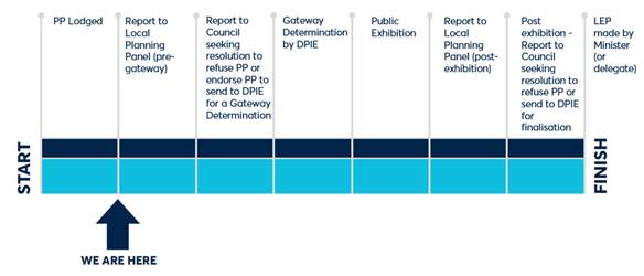
BACKGROUND
1. On 28 October 2019, the applicant, Planning Ingenuity Pty Ltd, on behalf of the landowner, Fabcot Pty Ltd, lodged a Planning Proposal with the City of Parramatta Council for land at 1 Windsor Road, North Rocks. The site was previously occupied by a Bunnings store however it is currently unoccupied.
SITE
2. The subject site is located on the corner of Windsor Road and James Ruse Drive. The site comprises two lots and is legally described as Lot 1 in DP 112482 and Lot 6 in DP 247452, with a total area of approximately 2.52ha. See Figure 1 and Figure 2 below.
Figure 1 – Site at 1 Windsor Road, North Rocks subject to the Planning Proposal
Figure 2 – Aerial view
3. The site has frontage to Windsor Road to the west and to James Ruse Drive (slipway) to the north. It is adjacent to, but does not have frontage to, North Rocks Road, being separated by Darling Mills Creek which runs adjacent to the site to the eastern and southern boundaries.
4. The main access to the site is from North Rocks Road with vehicular entry/exit and a pedestrian walkway via an elevated concrete bridge over Darling Mills Creek. Secondary vehicular access is available to Windsor Road.
5. The site is currently occupied by a large warehouse building (previously occupied by Bunnings Warehouse), with a gross floor area of 7,405m2. At grade car parking is provided on the site, with 260 spaces located predominantly to the south of the building with the remainder to the north and west.
CURRENT PLANNING CONTROLS
6. The subject site is zoned B6 Enterprise Corridor and SP2 Infrastructure (Public Transport Corridor) under the provisions of The Parramatta (former The Hills) Local Environmental Plan 2012 as shown in Figure 3.
B6 Enterprise Corridor SP2 Infrastructure (Public Transport Corridor) Zone
![]()
![]()
![]()
Figure 3: Zoning Map, Parramatta (former The Hills) Local Environmental Plan 2012
7. The site currently has a height limit of 16m under the Height of Buildings (HOB) map (refer to Figure 4).
 Figure 4: Height of Building
Map, Parramatta (former The
Hills) Local Environmental Plan 2012
Figure 4: Height of Building
Map, Parramatta (former The
Hills) Local Environmental Plan 2012
8. This site currently has a floor space ratio of 1:1 under the Floor Space Ratio (FSR) map (refer to Figure 5).
Figure 5: Floor Space Ratio Map, Parramatta (former The Hills) Local Environmental Plan 2012
9. FSR N 1:1![]()
![]()
This site contains Heritage Item 23 – Stone Bridge
Approaches and Foundation Plaque, Sydney Woollen Mills (refer to Figure 6).
 Figure 6: Heritage Map, Parramatta
(former The Hills) Local Environmental Plan 2012
Figure 6: Heritage Map, Parramatta
(former The Hills) Local Environmental Plan 2012
PLANNING PROPOSAL
10. The submitted Planning Proposal (dated 22 October 2019) seeks approval to permit ‘retail premises’ in the form of a supermarket and liquor shop on the site. The site is within the B6 Enterprise Corridor Zone which currently allows a range of non-residential (and commercial) uses but not ‘retail premises’. The site also contains a small portion of land zoned SP2 Infrastructure (Public Transport Corridor) along the Windsor Road frontage, but this does not affect any existing structures. The proposed future development of the site seeks to utilise the existing warehouse building on the site to accommodate a full-line Woolworths supermarket of 3,800m2 (including a BWS liquor store). The remainder of the existing building (3,015m2) will potentially be developed as a warehouse and distribution centre (non-retail) which is permitted under the current B6 zone that applies to the site. Further, an existing mezzanine level of 590m2 is proposed to accommodate office space that is also permitted within the current zone. A copy of the Planning Proposal is included at Attachment 1.
LOCAL & STRATEGIC PLANNING CONTEXT
State Planning Policies
11. The Planning Proposal is generally consistent with the relevant state policies and planning strategies including the Central City District Plan, State Environmental Planning Policies (SEPPs) and Ministerial Directions under Clause 9.1 of the Environmental Planning and Assessment Act 1979.
12. The Central City District Plan (CCDP) covers the area that includes Blacktown, Cumberland, Parramatta and The Hills LGAs. The role of this Plan is to help deliver the ten directions of the overarching Greater Sydney Region Plan A Metropolis of Three Cities and contains a number of planning priorities and objectives that address infrastructure provision and collaboration, liveability, productivity and sustainability objectives. Whilst the CCDP makes many references to future development in Parramatta, this principally relates to the Parramatta CBD where this site is not located. Nevertheless, the CCDP identifies the need to accommodate a significant amount of additional retail floorspace within the District over the next 20 years and the Planning Proposal will contribute to this objective. It is therefore considered that the Planning Proposal is consistent with the CCDP.
Local Strategies
13. Councils are required to prepare a Local Strategic Planning Statement (LSPS) by the State Government. The LSPS sets out the long-term vision for land use planning in a council’s local government area (LGA) and responds to broader priorities identified in the District Plans and integrates with a Council’s Community Strategic Plan. The LSPS provides greater weight to strategic planning in the broader plan making process and any new planning proposal must justify any inconsistency with this framework and the supporting Local Housing Strategy (LHS) and Employment Lands Strategy (ELS).
14. Council’s LSPS was published on 31 March 2020. The LSPS provides strategic direction on how the City of Parramatta is planning for the next 20 years. The site is not in an area that is specifically identified for growth within the LSPS, however given there is an existing undersupply of supermarket floorspace in the broader region as identified in the supporting economic impact analysis and the potential job creation from the proposal (detailed in the Assessment of Key Issues below), it is considered that the Proposal is generally consistent with the LSPS. More specifically, the proposal is consistent with Planning Priority 11 of the LSPS that seeks to “Build the capacity of…Local Centres and Employment Lands to be strong, competitive and productive”.
ASSESSMENT OF KEY ISSUES
15. The following section provides an analysis of the key issues associated with the Planning Proposal. It is recommended that the Planning Proposal be submitted to the Department of Planning, Industry and Environment (DPIE) requesting that retail premises up to a maximum of 3,800m2 be permitted on the site as an additional permitted use. The key issues that must be addressed relate to traffic and economic impacts and are discussed in detail below.
Traffic and Transport
16. An assessment of potential traffic and parking implications has been prepared by the applicant’s traffic consultant, Colston Budd Rogers & Kafes in support of the Planning Proposal. A copy of the traffic assessment is included at Attachment 2. Council officers have reviewed the applicant’s Traffic Report and raise the following comments:
Car Parking
17. The Traffic Report states that while the site currently provides approximately 300 parking spaces within the existing at grade car parking area, this will be reconfigured to provide a reduction to the total number of spaces resulting in approximately 256 car spaces in accordance with the RMS rates for supermarkets. In addition, bicycle and motor cycle spaces will be provided in accordance with Council requirements.
18. Based on the parking rates of The Hills DCP 2012, the proposed development would be required to provide a minimum 291 off-street parking spaces. Although the proposed provision of 256 parking spaces is lower than the parking requirement based on The Hills DCP 2012, Council’s Traffic and Transport team consider that the reduction in car spaces consistent with RMS rates is acceptable in this case as the site is also in close proximity to public transport (bus) services on Windsor Road which has the potential to further reduce private vehicle trips to the site.
Traffic Generation
19. The Traffic Report indicates that the previous Bunnings store on the site was surveyed by the RMS and found to generate approximately 200 vehicles per hour (two way) in the weekday afternoon peak hour. The report also states that based on surveys of similar supermarkets and RMS guidelines for warehouses and offices, the proposed development would generate approximately 420 vehicles per hour (two way) in the weekday afternoon peak hour. The report, then notes that during the afternoon peak period, a high proportion of the trips will be passing trade given the site’s location and heavy traffic flows on the adjacent road network. Accordingly, the report concludes that the increase in traffic on the surrounding road network compared to the previous Bunnings store (when excluding passing trade given these vehicles are already on the road network) is likely to increase by up to 100 vehicles per hour (two way). However, when this is distributed to the surrounding road network, increases in traffic on North Rocks Road and Windsor Road will be minor at approximately 50 vehicles per hour (two way).
20. Council officers consider that the trip generation from the site is likely to be lower than similar sites in the afternoon peak due to the high levels of traffic congestion within the area. A supermarket located in a residential area with low traffic congestion is likely to have significantly higher trip generation due the practicality of being able to access the site in a timely manner rather than sitting in traffic. It is considered that customers are likely to travel to other supermarkets that are easier to access during peak periods or may also travel to the site outside of these peak times to take advantage of the extended trading hours of supermarkets. For this reason, Council officers consider that the proposed centre is not likely to contribute to additional traffic as much as may occur in other locations. That said, whilst the proposal will have a relatively minor impact on the surrounding road network (based on the applicant’s modelling detailed above) when compared with the previously approved Bunnings store, Council officers and the applicant’s traffic consultant acknowledge that the adjacent road network is currently operating at capacity in the weekday afternoon peak. Notwithstanding the above, the site is well located to deliver improvements to the surrounding traffic network while also improving access to and from the site. This is discussed in detail below under Traffic and Transport Infrastructure Upgrades.
Traffic and Transport Infrastructure Upgrades
21. The Traffic Report recommends the provision of a third lane on the westbound off ramp of James Ruse Drive onto Windsor Road. The report indicates that the additional left turn lane will result in reduced delay/queues on the westbound off ramp as well as the ability to reallocate the traffic signalisation phases across the overall road network in this area, including the North Rocks Road approach to Windsor Road (benefitting right turn egress from the subject site).
22. It is noted that the site is well located to facilitate this additional left hand turn lane as it would require some land take along the James Ruse Drive frontage of the subject site which is currently undeveloped (e.g. some at grade car spaces, and landscape buffer). Given that both James Ruse Drive and Windsor Road are State roads the Planning Proposal and associated Traffic Report was also referred to Transport for NSW (TfNSW) for preliminary comment.
23. The key traffic issues raised by TfNSW are detailed in the below table:
Table 1: TfNSW preliminary comments and response
|
TfNSW Preliminary Comment |
Council Officer Response |
|
TfNSW recommend that “a site specific clause be inserted into the LEP limiting retail on the subject site to 3,800sqm only” to align with the traffic generating rate of a shopping centre < 10,000sqm (12.7 vehicle trips per 100sqm GLFA in PM peak period).
|
The applicant’s traffic assessment was based on a 3,800m2 supermarket with the balance of the site a warehouse/distribution centre. Therefore, Council officers agree with TfNSW’s recommendation that a site specific clause limiting retail on the site to 3,800m2 of retail space in total is appropriate.
|
|
TfNSW currently have no approved road proposal that impacts the subject site, however the James Ruse Drive intersection with Windsor Road is currently under investigation for potential future transport improvements in the medium to long term. TfNSW acknowledge that an additional left turn lane at the James Ruse Drive off ramp into Church St/Windsor road will not only benefit the broader network but will also benefits for the proposed development given the existing traffic capacity issues within the adjoining network. Should land be provided to facilitate the above additional lane, TfNSW will consider waiving a right hand turn restriction from the site into North Rocks Rd during afternoon peak. However, to provide flexibility for motorists exiting the site, a U-turn facility (roundabout) should be provided on North Rocks Road (in the vicinity of the site) to allow vehicles wishing to turn right out of the site onto North Rocks Road, can instead turn left, then do a U-turn nearby to allow them to get to Windsor Road, in order to assist right hand turn movements out of the site during peak periods. |
At this stage, TfNSW are still yet to prepare a Property Impact Plan detailing how much land will be required for the additional left turn lane on the James Ruse Drive off ramp onto Church Street/ Windsor Road. It is understood that TfNSW are currently in the process of preparing this plan for consideration by the applicant.
Should this be agreed to by the applicant, a suitable mechanism to facilitate the delivery of this land to State Government will need formalised (e.g. VPA with the State Government/Satisfactory Arrangements Provisions within the Planning Proposal or other) as this relates to a State Government owned road i.e. James Ruse Drive.
In relation to the U-turn facility, Council has care and control of North Rocks Road and it is therefore recommended that Council enter into negotiations with the applicant for the purposes of delivering a roundabout/U-turn facility on North Rocks Road within an appropriate location. It is noted that the proposed roundabout will ultimately need to be approved by Council’s Traffic Committee and would not need to be delivered until the supermarket opens, however to ensure certainty that the roundabout will be delivered by the applicant, it is recommended that the commitment to deliver the works is formalised as part of a VPA with Council.
|
|
The proponent is required to prepare a detailed Plan of Management that identifies practicable measures to minimise as much as possible queuing/congestion within the site associated with potential delays for motorists attempting to turn right from the site to North Rocks Road during peak periods. This is due to queues on the North Rocks Road approach to Windsor Road extending past the signalised site access road in the peak periods. The Plan of Management should be submitted to Council and TfNSW for review and comment as part of any future DA for the proposed development.
|
Noted. It considered that the requirements of the Plan of Management could be addressed through the delivery of the roundabout. |
24. Council’s Traffic and Transport team have also raised a number of issues relating to pedestrian and cyclist access to and from the site. The existing footpath on the southern side of the existing driveway bridge over Darling Mills creek is approximately 1.2m wide which is acceptable for the previous Bunnings use where most customers are picking up hardware and garden supplies by vehicle, but for a supermarket use the nature of shopping trips is different and is likely to generate a greater proportion of trips from pedestrians and/or cyclists.
25. It is therefore recommended that Council investigate the option of negotiating a planning agreement (in addition to the roundabout discussed in the above table) with the applicant to facilitate the provision of a shared path (at least 3m wide) which may require augmentation to the existing bridge (i.e. clip on structure) or alternatively a standalone bridge alongside to facilitate safe access for pedestrians and cyclists entering and leaving the site.
26. Based on the above, it is considered that there are still a number of outstanding traffic and transport matters that are yet to be resolved, however these relate to confirming a delivery mechanism for the proposed additional left turn lane at the James Ruse Drive off ramp into Church Street/Windsor Road (State infrastructure), new roundabout on North Rocks road to manage right hand turn movements from the subject site (Council infrastructure) and improved accessibility for pedestrians and cyclists.
27. It noted that while these delivery mechanisms are still yet to be confirmed, it is considered that the Planning Proposal has appropriately considered the traffic and transport impacts and there is sufficient scope to address how these items will be delivered following Gateway Determination being issued, but prior to public exhibition of the proposal.
28. Should Council endorse the Planning Proposal to proceed to Gateway Determination, Council will continue to liaise with State Government and the applicant to ensure that the identified traffic and transport works (both State and local) are confirmed via an appropriate delivery mechanism (either via VPA and/or planning provisions to be included within the Planning Proposal such as satisfactory arrangements).
Economic Impact
29. An Economic Impact Assessment has also been provided in support of the Planning Proposal prepared by Location IQ. The study presents an analysis of the trade area, its demographics, socio-economic profile, projected population growth and expenditure capacity. It also presents a detailed analysis of the retail profile of the trade area, including a competitor analysis, highlighting the supply and the indicative performance of food retailing stores in the area. Overall, the analysis supports the viability for the proposed supermarket at the subject site. A copy of the Economic Impact Assessment is included at Attachment 3.
30. The study notes that there is currently an undersupply of supermarket space within the identified trade area and any impacts on nearby centres or supermarkets both within and outside the main trade area are manageable. The economic impact analysis undertaken by Location IQ indicates that all impacts of the proposed supermarket at 1 Windsor Road, North Rocks on surrounding centres are within a reasonable competitive range of 10% or less. Therefore, the proposal will not threaten the viability of any nearby centre or supermarket, particularly given the current undersupply of supermarket floorspace in the trade area. In addition, the impacts from the proposed development on other centres will be offset over time given the underlying population growth (and associated growth in retail spending) within the trade area and within the broader region. The identified trade area for the proposed supermarket as contained in the economic impact analysis is shown in Figure 7 below.
![]()

Figure 7: Main Trade Area and Competition (extracted from Economic Impact Assessment)
31. Furthermore, the study notes that the proposed supermarket and associated liquor store, coupled with the warehouse and distribution and ancillary office use will provide both direct and indirect employment generation in the region of 1,196 jobs.
32. Council’s Economic Development Team has undertaken a detailed review of the Economic Impact Assessment and agreed with its findings and raised no objection to the Planning Proposal proceeding. On this basis, the Planning Proposal is supported on economic grounds particularly given the potential job creation associated with the proposed development and existing undersupply of supermarket space within the trade area as articulated in the supporting economic impact analysis.
33. It is noted that the Economic Impact Assessment only assesses the potential economic impacts of the proposed development being a supermarket and liquor store of 3,800m2, a warehouse and distribution centre and associated office space. However, should the Planning Proposal proceed as submitted and allow retail premises as an additional permitted use, there is potential for a much larger retail centre to be developed on the site that could include a large number of specialty stores or discount department stores. Such a centre would have a profoundly different impact on surrounding centres that has not been adequately considered should the proposed LEP amendment proceed in its current form. The potential for a much larger centre would also lead to significantly different traffic generation from the site as noted in the traffic and transport section above.
34. In order to address this concern, it is proposed that the additional permitted use of retail premises be limited to a maximum of 3,800m2 in accordance with the proposed supermarket and liquor store development included in the Planning Proposal. It is proposed to include this limit as part of the Additional Permitted Use provisions within Schedule 1 of the Parramatta (former The Hills) Local Environmental Plan 2012. This will ensure that retail uses are capped on the site and any additional retail uses do not occur on the site over and above those that have already been subject to a detailed impact analysis.
Heritage
35. A Heritage Impact Assessment has been prepared by Extent Heritage Advisors in support of the submitted Planning Proposal and is included at Attachment 4. The site contains a locally listed heritage item referred to as, ‘Stone Bridge Approaches and Foundation Plaque, Sydney Woollen Mills’, Item A23 in Schedule 5 of The Parramatta (former The Hills) Local Environmental Plan 2012. The only known built heritage elements on the site is a portion of wall with inset foundation plaques located along Windsor Road, directly adjacent to the footpath, which is bounded at the rear by metal cyclone fencing.
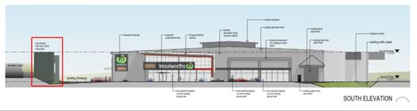 Figure 8:
Proposed works with existing built heritage item outlined in red
Figure 8:
Proposed works with existing built heritage item outlined in red
36. The proposed future development of the site seeks to utilise the existing warehouse building, with minor alterations including adjustments to some openings, new shopfront glazing and new awnings. All works would be clear of the existing built heritage fabric by approximately 25 metres, and hence there would be no physical impact on the heritage item. No ground penetrating works are proposed that could impact upon potential archaeological resources (refer to Figure 8).
37. There is no direct change proposed to the built heritage item and therefore no impact to its heritage fabric.
38. Council’s Heritage Advisor has reviewed the Proposal and advised that the proposed planning amendment will have no impact on the heritage significance of the item on site. A full assessment of potential heritage impacts would be required as part of the future detailed development application and would address any potential impacts, including visual impacts, however these are expected to be minimal.
Flooding
39. An Overland Flow Assessment report has been prepared by BMT WBM Pty Ltd in support of the submitted Planning Proposal. A copy of the Overland Flow Assessment is included at Attachment 5. Figure 9 below shows there is some flood affectation in the 1% AEP (100 year ARI) flood event but only around the eastern and southern edges of the site (the immediate area of Darling Mills Creek).
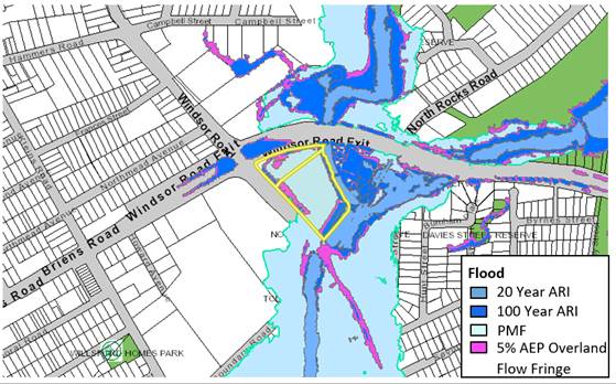 Figure 9: Flood
Affectation
Figure 9: Flood
Affectation
40. Hazard High Risk Low Risk![]()
![]()
![]()
Figure 10 shows there is an area
of high flood hazard flow (shown in red), but affects
the site only the outer edges and is located near the Darling Mills Creek.
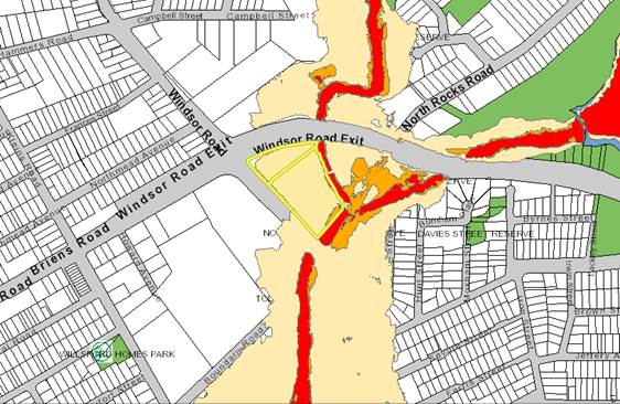
Figure 10: Flood Risk – map showing ‘low hazard’ flood zone in yellow
41. The change in use from the hardware warehouse (Bunnings) to a supermarket is predicted to increase the number of occupants on the site, which will increase the flood risk associated with this development. However the flood studies indicate minimal intrusion of high hazard flooding onto the site and only minor intrusion of moderate hazard 1% AEP (100 year ARI) flooding around the edges of the land. This means increasing the number of occupants on the site is not likely to generate an increased risk from overland flow flooding.
42. As the proposal is not seeking to alter the extent of the existing building envelope on the site, it does not appear to be obstructing any significant overland flow conveyance path (‘floodway’) nor will it cause unacceptable displacement of overland flow floodwaters onto other properties or lands.
43. In conclusion, Council’s Senior Catchment and Development Engineer advised that there is no apparent impediment to the proposal proceeding with respect to flooding impacts and affectation. Potential flood impacts would be further considered and addressed as a part of the future detailed development application.
PLANNING AGREEMENT
44. Under the City of Parramatta Planning Agreements Policy (adopted 26 November 2018) “Council will consider, as a matter of public interest, whether satisfactory arrangements have been or will be made for the provision of community infrastructure, given the likely increase in demand for services and infrastructure” (clause 2.5.2). The Policy also seeks to ascribe a value to any planning agreement related to the land value uplift as a result of the planning proposal.
45. The submitted Planning Proposal is not accompanied by a Letter of Offer seeking to enter into a Planning Agreement with Council as it is only proposing to include retail premises as an additional permitted use on the site and is not seeking any density uplift. However, given the issues identified within the Traffic and Transport section above, a Planning Agreement may provide an appropriate mechanism to ensure that issues associated with the increase in demand for infrastructure as a result of the Planning Proposal are satisfactorily addressed.
46. It is therefore recommended that Council authorise the Chief Executive Officer (CEO) to negotiate a Planning Agreement on behalf of Council. Should the Planning Agreement proceed, the outcome of the negotiations would be reported back to Council prior to its concurrent public exhibition with the Planning Proposal. The key elements of the Planning Agreement would address the following:
· delivery of a roundabout on North Rocks Road, and
· augmentation of the existing bridge over Darling Mills Creek to facilitate increased capacity for pedestrian and cyclists.
47. In addition, as noted in the Traffic and Transport section above, a mechanism to deliver a third lane on the James Ruse Drive off ramp should be agreed to by the State Government and the proponent prior to any public exhibition of the Planning Proposal. This will likely require some land take on the northern boundary of the site but will not impact the existing structures on site. Should a Planning Agreement be required to deliver the additional lane, it would be undertaken at State level as James Ruse Drive is not a Council owned and managed road.
SITE SPECIFIC DEVELOPMENT CONTROL PLAN
48. It is noted that the Planning Proposal is only seeking to include a supermarket and associated liquor store as an additional permitted use within Schedule 1 of the Parramatta (former The Hills) Local Environmental Plan 2012, and that the use is proposed to be incorporated within an existing building on site. It is therefore not considered necessary to include a site-specific DCP to support the proposal in this instance. The existing provisions within The Hills Shire DCP 2012 are considered sufficient to manage the assessment of any development application on the site should the proposal proceed.
PLAN-MAKING DELEGATIONS
49. Revised delegations were announced by the then Minister for Planning and Infrastructure in October 2012, allowing councils to make LEPs of local significance. On 26 November 2012, Council resolved to accept the delegation for plan-making functions. Council has resolved that these functions be delegated to the CEO.
50. Should Council resolve to endorse the Planning Proposal to proceed, it is recommended that Council request that it exercise its plan-making delegations. This means that once the Planning Proposal has been to Gateway, undergone public exhibition and been adopted by Council, Council officers will deal directly with the Parliamentary Counsel Office on the legal drafting and mapping of the amendment. The LEP amendment is then signed by the CEO before being notified on the NSW Legislation website.
CONCLUSION AND NEXT STEPS
51. This report recommends that the Planning Proposal for 1 Windsor Road, North Rocks proceed to Gateway.
52. Should the proposal proceed and a Gateway Determination be issued, the Planning Proposal will be placed on public exhibition and the outcomes of the exhibition will be reported to the Local Planning Panel if any objections are received. If no objections are received, the matter will be reported directly to Council post-exhibition.
CONSULTATION & TIMING
53. The Planning Proposal and supporting documents were referred internally to Council’s Heritage, Flooding, Traffic and Transport, Economic Development teams and externally to the TfNSW for comment.
54. No public consultation has been undertaken relating to this Planning Proposal. Should Council resolve to proceed with the Planning Proposal, it (and all related information) will be submitted to the DPIE for Gateway Determination. Community consultation will be undertaken as required by the Gateway Determination.
FINANCIAL IMPLICATION FOR COUNCIL
55. Should Council resolve to proceed with the Planning Proposal, the costs incurred in conducting the community consultation are covered by the fees associated with the submission of the Planning Proposal request. Should a Planning Agreement be required to support the Planning Proposal, a separate report will be provided to Council outlining all financial implications associated with such an agreement.
Jane Liang
Project Officer Land Use
Michael Rogers
Land Use Planning Manager
David Birds
Group Manager, City Planning
Jennifer Concato
Executive Director City Planning and Design
|
1⇩ |
Planning Proposal for 1 Windsor Road, North Rocks |
46 Pages |
|
|
2⇩ |
Traffic Review |
8 Pages |
|
|
3⇩ |
Economic Impact Assessment |
61 Pages |
|
|
4⇩ |
Heritage Impact Assessment |
9 Pages |
|
|
5⇩ |
Flooding Report |
8 Pages |
|
REFERENCE MATERIAL
ITEM NUMBER 6.3
SUBJECT Pre-Gateway: Planning Proposal for land at 114-118 Harris Street, Harris Park
REFERENCE RZ/9/2018 - D07402799
REPORT OF Project Officer Land Use
|
LAND OWNER: Harris Street Developments Pty Ltd
APPLICANT: Think Planners Pty Ltd
Development Applications CONSIDERED BY SYDNEY CENTRAL CITY PLANNING PANEL – Nil.
PURPOSE:
To seek the Local Planning Panel’s advice on a Planning Proposal at 114-118 Harris Street, Harris Park for the purposes of seeking a Gateway Determination from the Department of Planning, Industry and Environment. This report also deals with the preparation of a site-specific Development Control Plan a draft Planning Agreement for this site. |
|
That the Local Planning Panel consider the following Council officer recommendation in the Panel’s advice to Council:
(a) That Council endorse for the purposes of seeking a Gateway Determination from the Department of Planning, Industry and Environment, the Planning Proposal at 114–118, Harris Street, Harris Park (included as Attachment 1) which seeks the following amendments to Parramatta Local Environmental Plan 2011 in relation to the subject site:
1. Increase the maximum building height from 54 metres (15 storeys) to 126 metres (32 storeys); 2. Increase the maximum FSR on the Floor Space Ratio Map from 4:1 to 10:1; 3. Inclusion of controls to deal with management of flooding including, but not limited to, provisions for safe refuge and ensure the building is capable of withstanding and does not obstruct flood flows; and 4. Amend the Special Areas Provisions Map to identify the site and add site-specific controls that provide for the following: a. Provision outlining that the mapped FSR of 10:1 is subject to the sliding scale requirements of Clause 7.2 of the draft LEP provisions of the Parramatta CBD Planning Proposal. b. Requirement for minimum 1:1 commercial floor space c. Maximum parking rates, in line with the resolution of the City of Parramatta Council on 26 November 2019 with regard to parking rates in the Parramatta CBD Planning Proposal. d. Requirement to demonstrate Experiment Farm is not overshadowed by development of the site.
(b) That the Planning Proposal be forwarded to the Department of Planning, Industry and Environment to request the issuing of a Gateway Determination.
(c) That a draft site-specific Development Control Plan (DCP) be prepared and reported to Council prior to its public exhibition. This draft DCP should address, at a minimum:
1. Built form and massing; 2. Building setbacks; 3. Flooding; and 4. Road widening.
(d) That with regards to a Planning Agreement for the subject site:
1. the applicant be invited to negotiate a Planning Agreement in line with Council’s policy position on Planning Agreements in the Parramatta CBD; 2. delegated authority be given to the Chief Executive Officer to negotiate a draft Planning Agreement with the landowner in relation to the Planning Proposal on behalf of Council; and 3. the outcome of the negotiations shall be reported back to Council prior to the draft Planning Agreement being placed on public exhibition.
(e) That the Planning Proposal, DCP and Planning Agreement are concurrently exhibited. (f) That Council advises DPIE that the Chief Executive Officer will not be exercising the plan-making delegations for this Planning Proposal as authorised by Council on 26 November 2012. (g) Further, that Council delegate authority to the Chief Executive Officer to correct any minor anomalies of a non-policy and administrative nature that may arise during the Planning Proposal, DCP and / or Planning Agreement processes. |
PLANNING PROPOSAL TIMELINE
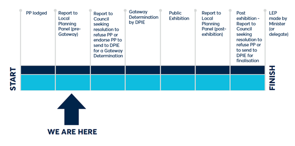
INTRODUCTION
1. The Planning Proposal for 114 – 118 Harris Street is one of three Planning Proposals for land at the corner of Parkes and Harris Streets. Other Planning Proposals have been lodged for 24 Parkes Street and 26-30 Parkes Street. These three sites are shown in Figure 1. This report addresses the Planning Proposal for site 3 in Figure 1.
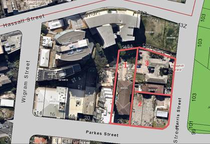
Figure 1: Three adjacent Planning Proposals, Harris Park
[1: 24 Parkes Street; 2: 26–30 Parkes Street; 3: 114–118 Harris Street)
2. The background to these three Planning Proposals extends over a period of approximately three years with extensive consultation with Council officers during that time. During this time Council staff have raised a number of issues concerning development of the sites; the main issues are summarised as follows:
· The need to satisfactorily resolve setbacks for the sites and particularly on the western boundary of 26–30 Parkes Street. This was necessary to ensure that the adjoining site to the west at 24 Parkes Street does not suffer from site isolation and that there is adequate space between buildings.
· Possible overshadowing impacts on the nearby conservation areas of Harris Park West, and Experiment Farm, and also Experiment Farm Cottage contained on the State Heritage Register. To establish the magnitude of possible overshadowing impacts Council officers have undertaken extensive analysis as part of the Parramatta CBD Planning Proposal.
· Council staff have been of the consistent view that site consolidation is the best means to secure good built form and urban design outcomes and avoid site isolation of 24 Parkes Street. Also, with site amalgamation the permitted FSR for the sites would not be subject to the sliding scale restrictions under the Parramatta CBD Planning Proposal and may be able to achieve a maximum permitted FSR of 10:1.
3. Nevertheless, after consideration Council officers have reached the conclusion that 114–118 Harris Street can be reported as a stand-alone Planning Proposal. As will be discussed further in this report, this site may be developed without amalgamation to achieve acceptable urban design and planning outcomes, and the Planning Proposal is consistent with the Parramatta CBD Planning Proposal. Urban design and planning issues are largely resolved and can be further dealt with through the preparation of a DCP for the site.
SITE DESCRIPTION
4. The subject site has an area of 1,776 m² and its legal description is as follows: SP 35413 (114, Harris Street) and SP 53257 (116 – 118, Harris Street). The site is shown in Figure 2.
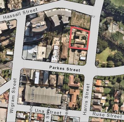
Figure 2 – Location of Site (site shown outlined in red)
5. The site is on the south eastern edge of the Parramatta CBD. To the east of the site is the Robin Thomas Reserve, which is one of the few city centre open space areas and contributes to the character and amenity of the area. Clay Cliff Creek (an open channel) adjoins the northern boundary of the site.
6. The immediate locality is characterised by a mix of uses and built form. To the west of the site is generally aged building stock that is currently undergoing a transition in character because of development approvals under construction and the recent Planning Proposal at 14 – 20 Parkes Street, Harris Park.
CURRENT PLANNING CONTROLS
7. The site is subject to Parramatta LEP 2011 and the following key provisions apply to the site:
· zoning: B4 Mixed Use;
· maximum Height of Buildings (HOB): 54 metres;
· maximum Floor Space Ratio (FSR): 4:1.
8. The site is not listed as a heritage item. However, it is in close proximity to a number of heritage items and conservation areas as listed below and illustrated at Figure 3.
· 100768: Experiment Farm Cottage and Environs (State Significance);
· A00768: Experiment Farm Archaeological Site (State Significance);
· Experiment Farm Conservation Area.
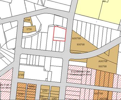
Figure 3: Heritage properties in relation to subject site (site shown outlined in red)
Flooding
9. The site is affected by the probable maximum flood (PMF) event, as well as the 1:100 and 1:20 year flood. The northern margin of the site adjacent to Clay Cliff Creek is subject to high hazard flooding. Flood maps are shown in Figures 4 and 5.
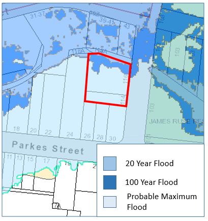
Figure 4: Flooding (1:20 and 1:100 year flood) (site shown outlined in red)

Figure 5: Flooding Hazard Levels (site shown outlined in red)
DESCRIPTION OF THIS PLANNING PROPOSAL AND COMPARISON OF CONTROLS WITH CURRENT AND PARRAMATTA CBD PLANNING PROPOSAL
10. On 27 August 2018, a Planning Proposal was lodged for 114–118 Harris Street, Harris Park to remove the maximum height of building (HOB) under the incentive HOB map and to increase the maximum Floor Space Ratio from 4:1 to 14.5:1.
11. Following consultation with Council officers the Planning Proposal has been modified to seek the following amendments to Parramatta LEP 2011:
· Apply a maximum building height of 145 metres
· Apply a mapped FSR of 10:1
· Include a provision subjecting the mapped FSR of 10:1 to the sliding scale requirements of Clause 7.2 of the draft LEP provisions of the Parramatta CBD Planning Proposal.
· Include an additional site specific clause requiring a mandatory 1:1 of commercial floor space.
· Include a maximum car parking rate in accordance with the Parramatta CBD Strategic Transport Study and resolution of Council of 10 April 2017.
12. The applicant’s Planning Proposal is accompanied by traffic, wind and flood studies and a reference design (most recent reference design included at Attachment 2).
13. The Planning Proposal seeks to redevelop the site as a multi-storey mixed-use apartment building comprising one level of retail outlets, one level of commercial offices, 35 levels of residential apartments and one level of communal open space. Approximately 218 new dwellings will be delivered by the proposal. It is expected that there will be four levels of basement car parking. An illustration of the proposed design concept for the site is shown in Figure 6 below.
Figure 6: Eastern elevation of design concept for 114 – 118 Harris Street facing Harris Street
14. Table 1 compares the key planning controls recommended for the subject site with the current controls and the Parramatta CBD Planning Proposal.
Table 1: Planning Proposal comparison to current controls and Parramatta CBD Planning Proposal
|
Scenario |
Current Controls |
Parramatta CBD Planning Proposal Controls |
Recommended Site-specific Planning Proposal controls |
|
Site Area – 1,776m2 |
|||
|
Land zoning |
B4 Mixed Use |
B4 Mixed Use |
B4 Mixed Use |
|
FSR |
4:1 |
Base: 4:1 Incentive: 10:1 (11.5 with bonus).
However, under clause 7.2 of the draft CBD Planning Proposal LEP provisions the site is subject to a sliding scale, as resolved by Council on 24 March 2019 |
10:1
Under the sliding scale the permissible FSR for the site is 9.88:1 (which allows 11.362:1 with design excellence. This is reflected in the reference design).
|
|
HOB / solar access plane
|
54m (15 storeys)
|
Base: 54m
Includes a new “Area 1 “control applied to protect Experiment Farm. Council resolved to protect solar access to Experiment Farm between 10 am and 2 pm midwinter.
|
The Height of Buildings map will show 126 metres 32 - storeys) (145m - 38 storeys with design excellence).
A control to protect Solar Access to Experiment Farm will also affect the permitted maximum height. The control will be modelled on the Parramatta CBD Planning described in the adjoining row. Modelling suggests Experiment Farm will not be overshadowed if the building is at or below 145m. Given the height is based on preliminary modeling there is a small risk that a building at 145m could overshadow when detailed design work is completed. However this clause will ensure that a more detailed design prepared at Design Competition and Development Application stage will still comply with the requirement to keep Experiment Farm free from shadow at the specified periods of the day. |
|
Land Acquisition |
Nil |
In the land reservation acquisition map for the Parramatta CBD Planning Proposal the Harris Street frontage of the site is subject to the requirement for 3.5m road widening. |
It is recommended that a Planning Agreement be negotiated to secure a 3.5m widening along Harris street.
|
|
Minimum Commercial Floor Space |
Nil |
Minimum 1:1 commercial floor space required in mixed use development. |
Insert clause that will require a minimum commercial floor space of 1:1. |
|
Active Street Frontages |
N/A |
Active frontage proposed for Harris Street. |
Active frontage provided on Harris Street via DCP controls. |
|
High performing buildings (residential) |
N/A |
5% high performing building bonus. |
High performing building bonus is not supported (refer to detailed comments below). |
|
Parking |
Parking Rates
|
Endorsed Parking Rates consistent with City of Sydney CBD Parking rates - Category A. |
Insert clause setting parking rates as per Parramatta CBD Planning Proposal. |
|
Yield |
Approximately 89 dwellings* |
Approximately 218 dwellings. |
Approximately 218 dwellings. |
*Based on Average Unit size of 80m2
15. In summary, the Planning Proposal recommended for the subject site seeks to amend the core planning controls of FSR and HOB in a manner that is consistent with the Parramatta CBD Planning Proposal as described in Table 1.
ASSESSMENT OF THE SUBJECT PLANNING PROPOSAL
Sliding Scale / Amalgamation Issues
16. As noted earlier, this Planning Proposal is one of three Planning Proposals at the corner of Parkes and Harris Streets. Other proposals are for 24 and 26 – 30 Parkes Street (see Figure 7- labelled 1 and 2 respectively). The other two Planning Proposals sites also are below 1,800m2 in area and trigger the sliding scale provisions. In both cases the applicants have requested that sliding scale provision not be applied to their site.
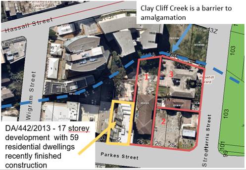
Figure 7– Adjoining land subject to site-specific Planning Proposals
17. Officers consider that amalgamation of these sites would maximise the FSR that can be achieved as the sliding scale controls would not be applied to sites that are amalgamated to achieve an area of 1,800m2 or greater. It would also allow for the FSR to be achieved with more generous tower setbacks and separations which are desirable from an urban design viewpoint.
18. Council Officers met with all the applicants to determine whether amalgamation arrangements could be agreed. The applicants were unable to reach an agreement and have requested that their respective Planning Proposals be reported to Council with each application assessed separately assuming the sites will be developed as individual sites. The Planning Proposals for the adjoining sites are expected to be reported to the Local Planning Panel and Council once further information submitted by these applicants has been assessed.
19. If the Parramatta CBD Planning Proposal is finalised as per Council’s current policy framework then each of these site will be permitted to be developed individually subject to application of the sliding scale. Given this Council Officers consider that it is acceptable to proceed with individual assessments for these site-specific Planning Proposals.
Setback Issues in absence of site amalgamation
20. Figure 7 also shows the amalgamation options for the subject site are limited to the two adjoining sites that are the subject of the other applications due to the creek.
21. If this site is developed independently the only way the adjoining sites can achieve the minimum 1,800m2 to avoid the application of sliding scale is for those two sites to amalgamate (i.e. sites 1 and 2). If they were to amalgamate in the future the “L’ shaped site created is not an efficient shape for a redevelopment and setbacks and tower separations that can be achieved whilst still allowing a viable floor plate are more limited. If the sites are all developed independently setback and separation limitations are exacerbated.
Application of High Performing Building Bonus
22. The applicant is seeking to apply the high performing building bonus to this site. The bonus allows the developer to achieve an additional 5% bonus if they are able to achieve higher environmental performance criteria than would otherwise be required. However the site does not meet the criteria to be eligible for this bonus as the site must have a site area of 1,800m2 and the subject site is 1,776m2.
23. The applicant’s justification for this variation is:
· The subject site is 24m² under the minimum 1,800m² required to be eligible for the 0.5 high performing building floor space ratio bonus. The site represents an insignificant shortfall in the minimum area required to obtain this bonus.
· In this case, a superior environmental outcome can be achieved if the clause is applied to this slightly undersized lot. The benefits of the high performing building which result in a development that achieves lower energy and water usage will bring a larger public benefit to the City of Parramatta.
· Rigid application of this control in this circumstance is unwarranted and does not achieve the overall intentions and objectives of the high performing building provisions.
24. If permitted it would allow a design for the site with base FSR of 9.8:1 (applying sliding scale), plus design excellence (15% of base FSR), together with high performing building bonus (5% of base FSR) to achieve an FSR of 11.8:1. Compared to the FSR of 11.4:1 which is being recommended for the subject Planning Proposal.
25. Council officers do not support the application of this bonus because it would undermine the sliding scale provisions that are being applied to encourage higher FSR bonuses to be available if amalgamation occurs to achieve larger lots. Allowing the high performing building bonus without meeting the site criteria would set an unacceptable precedent which would undermine the sliding scale provisions as developers could achieve higher FSR without having to amalgamate. Promotion of amalgamation via the sliding scale mechanism is a critical objective that underpins the achievement of the broader objective of the Parramatta CBD Planning Proposal
Built form and urban design
26. Council’s City Design Unit has reviewed the applicant’s urban design reports and reference design drawings. Table 2 below compares the setbacks currently being considered by Council Officers given urban design and flooding issues and those proposed by the applicant.
Table 2: Comparison of setbacks proposed by Council and those in most recent reference design
|
Council officer proposed setbacks |
Applicant's setbacks |
|
a. Podium
|
|
|
0m to south
|
0m to south |
|
1.5m to east
|
1m to east |
|
6m to the north |
6m to the north |
|
0m to west
|
0m |
|
b. Tower
|
|
|
9m to south
|
9m to south |
|
4.5m from east podium along Harris Street
|
Levels 5-34, 2m and Levels 35-37, 11m from east podium along Harris Street |
|
1.5m to 2 m from north podium
|
0m from north podium |
|
9m to west
|
9m to west |
27. The applicant argues their proposed setbacks are acceptable and this demonstrates they can achieve an FSR of up to 11.8:1. Council’s City Design Unit are yet to accept the setbacks proposed but are committed to continue discussions on what the appropriate setback might be and whether their current recommended setbacks might be relaxed. Currently the key concern of Council officers is that reducing the setbacks will impact on the streetscape and perceived mass of the buildings and where they bring buildings closer to adjoining sites may impact on the amenity of residents of adjoining future buildings at 24 and 26 – 30 Parkes Street.
28. One of the principles of the Parramatta CBD Planning Proposal is that height should only be limited in cases where there are overshadowing or other factors that require a specific height control to be imposed. Otherwise the only restriction on height are aeronautical constraints. Due to the overshadowing of Experiment Farm this is one of the sites where height has been limited. This means that larger setbacks potentially impacts on the ability of the applicant to achieve a higher FSR on this site because the height of the building cannot be increased to retain the maximum FSR. Therefore the setbacks negotiation will have a significant impact on the maximum FSR achievable on this site
29. A draft DCP reflecting the outcome of these further discussion on setbacks will be reported to Council for endorsement so it can be exhibited with the Planning Proposal. This report recommends Council permit the maximum FSR in accordance with the Parramatta CBD Planning Proposal so if the applicant is able to satisfy Council Officers that their setbacks are appropriate that they can then achieve this maximum FSR without having to amend the Planning Proposal. This approach allows an appropriate level of flexibility.
Heritage
30. It is noted that the subject site does not contain any heritage items or is within a conservation area. However, the impact of future development must ensure that solar access to Experiment Farm is protected.
31. The proposed building envelope and indicative architectural plans within the Urban Design Analysis show the development does not overshadow Experiment Farm. Council Officers are satisfied that there is no overshadowing impact to Experiment Farm under the proposed indicative massing. Further refinement and detail will need to be provided during the Design Excellence process and later at the Development Application stage to ensure this matter is appropriately managed.
Flooding
32. A Flood Impact Assessment has been prepared for the applicant by Cardno Pty Ltd with the report demonstrating the storm water flooding extent and behavior for the Planning Proposal.
33. Council’s Senior Catchment and Development Engineer has reviewed the applicant’s flood study, along with flood studies for the adjacent Planning Proposals at 24 and 26 to 30 Parkes Street and has commented as follows:
· There are potentially two sources of flooding: 1. From Clay Cliff Creek, for which Council’s adopted flood levels may be used. 2. From overland flow (rainfall) in the local catchment above the site.
· The applicable flood planning level is the higher of these flood levels for the critical 1% AEP flood event plus 0.5m freeboard.
· Minimum floor levels for habitable floors/rooms shall be the flood planning level.
· Development / buildings must not obstruct the floodway. There is a floodway beyond the channel of Clay Cliff Creek that is a critical issue but should be resolvable by design.
· The provision of a 6 metres setback from the canal edge at ground level (and at least 4 metres overhead clearance above the surface) is considered important to allow for floodwaters to pass alongside and above the channel. This is important in ensuring that the floodway is not unreasonably obstructed by the development and will in turn help to satisfy the requirements of the Minister's Section 9.1Direction.
· Council prefers that there are no basements. If basements are pursued (for car parking only), the basement driveway entry must be provided with a flood barrier crest at or above the flood planning level. Wingwalls to this level and other passive measures such as raised entries to stairs to prevent flood waters entering the basement must be provided to the flood planning level. Additionally floodwaters higher than the flood planning level up to the Probable Maximum Flood (PMF) must be excluded from the basement. This can be done with bund walls, self-actuating flood gates on the driveway crest and elsewhere, flood doors on stairwells etc and other measures as needed.
· The Applicants have begun to address Flood Emergency Response Plans, including ‘shelter in place’ facilities and evacuation. This can be taken further as details are developed.
· Under DCP 2011 and the Council Floodplain Risk Management Policy, Council does not permit ‘Sensitive Uses’, including centre-based child care, in flood prone land (that is affected by the PMF).
34. It is concluded that the site is generally suitable for residential development from a flood risk perspective. The Planning Proposal is considered to be capable of being consistent with Section 4.3 Flood Prone Land of the Section 9.1 Ministerial Direction subject to inclusion of controls described below.
35. There are two nearby sites that all front onto Clay Cliff Creek where the approach to applying the flood controls likely to be introduced as part of the Parramatta CBD Planning Proposal have been managed differently over time.
|
Site |
Controls |
|
12A Parkes Street |
Planning proposal was finalised with controls included in LEP |
|
14-20 Parkes Street |
Council initially proposed some controls in the DCP but as part of the Planning Proposal finalisation process they intend to include these controls in the LEP |
36. Given the Department of Planning most recent decision on 14-20 Parkes Street it is recommended that provisions be added to the Planning Proposal that require the development to address floodplain risk management in a manner consistent with the approach proposed in the Parramatta CBD Planning Proposal. The controls will require safe areas for refuge and ensure the building is capable of withstanding and does not obstruct flood flows.
Traffic and Transport
37. Council’s Traffic and Transport Section has reviewed the subject Planning Proposal, along with the adjacent Planning Proposals for 24 Parkes Street and 26 – 30 Parkes Street. The section supports the maximum parking provision for each site in line with the rates of the strategic transport study for the Parramatta CBD that Council endorsed on 10 April 2017. Council resolved to include reduced parking rates in the CBD Planning Proposal, pending results of the forthcoming detailed (mesoscopic) study. This resolution was in part to allow site-specific Planning Proposals to proceed ahead of the detailed modelling. The rates will be those included in the Draft Parramatta CBD Planning Proposal when it was endorsed on 26 November 2019 and include the following generic rates for residential and commercial uses as well as other rates for specific uses:
a. Residential parking rates
|
Type of Apartment |
Spaces/unit |
|
3-bedroom |
1 space/unit |
|
2-bedroom |
0.7 spaces/unit |
|
1-bedroom |
0.3 spaces/unit |
|
Studio |
0.1 spaces/unit |
b. Commercial parking rates
If the FSR > 3.5:1
M = (G * A) / (50 * T)
where:
M = maximum number of parking spaces
G = GFA of all office/business premises in the building (m²)
A = Site Area (m²)
T = Total GFA of all buildings on the site (m²)
38. The Section has also commented that traffic modelling is not required to be conducted as part of the Traffic Analysis submitted as part of the Planning Proposal given Council is conducting a detailed traffic study that investigates the cumulative impact of traffic generation under the 15:1 FSR growth scenario.
39. The Planning Proposal is required to take into consideration a provision on the Local Reservation Acquisition (LRA) Maps of the draft Parramatta CBD Planning Proposal that provides for local road widening on the western side of Harris Street. The width of the widening is approximately 3.5 metres. The widening has been incorporated into the strategic traffic modelling for the CBD Planning Proposal, and at this stage it has been jointly agreed by Transport for NSW and Council to facilitate the creation of a potential additional lane along the west side of Harris Street. Therefore, it has been included in the Local Reservation Acquisition Maps for the draft CBD Planning Proposal. This is discussed further in the section of this report relating to a Planning Agreement.
Summary of Assessment
40. The redevelopment of the site without amalgamation does not result in optimal urban design and planning outcomes but the Planning Proposal recommended by Council Officers will be generally consistent with the CBD Planning Proposal as endorsed by Council and will deliver acceptable outcomes and so can be supported.
41. Council officers also recommend that Council advise DPIE that the CEO will not be exercising the plan-making delegations for this Planning Proposal. This is on the basis that Council is also advancing the Parramatta CBD Planning Proposal (which affects this site), and the Parramatta CBD Planning Proposal has not yet been approved by DPIE for finalisation.
SITE-SPECIFIC DEVELOPMENT CONTROL PLAN
42. It is recommended that a site-specific DCP be prepared that will deal with issues including, but not limited to, built form and massing, setbacks, flooding and road widening.
PLANNING AGREEMENT
43. It is expected that a Planning Agreement will be negotiated in line with the Parramatta CBD Community Infrastructure framework. Council’s negotiating position for the Planning Agreement will be based on the endorsed value sharing rates for the Parramatta CBD, namely $150/m2 of residential floor space. The basis of the amount for payment is set out in the table below.
Table xx: Calculations for payment of monetary contribution
|
Development parameters |
|
|
Site area |
1776 m2 |
|
Base Gross Floor Area |
4:1 = 4 x 1,776 m2= 7104 m2 |
|
Incentive Floor area (Phase 1) |
9.88:1 = 9.88: x 1776 m2 =17,546.88 m2 |
|
Uplift in Gross Floor Area |
(17,546.88 – 7104) = 10,442.88 m2 |
|
Community infrastructure payment required at $150 /m2 |
$1,566,432 (Mixed use development with commercial and residential use) |
44. The landowners of the site have submitted a letter of offer (Attachment 3 ) proposing to make voluntary financial contributions consistent with the Phase 1 Value Sharing methodology that will provide contributions towards Community Infrastructure.
45. As noted above, the Parramatta CBD Planning Proposal LRA map contains provisions for a 3.5 metre road widening along Harris Street at this site. It is recommended that Council seek to negotiate inclusion of this road widening in the subject Planning Agreement for the site, noting that Council’s policy position is to assign a nominal value ($1) to land dedicated where the Applicant receives the benefit of the FSR from that land.
46. In order to progress a Planning Agreement Council Officers require delegation from Council to negotiate a Planning Agreement in association with this Planning Proposal. It is recommended that delegated authority be given to the Chief Executive Officer to negotiate a Planning Agreement with the landowners on behalf of Council and that the outcome of negotiations be reported back to Council before its public exhibition. These negotiations are to be undertaken in line with Council’s recently endorsed Planning Agreement Policy 2018.
47. In addition, Council Officers recommend the negotiation of a draft Planning Agreement should take into account the following matters:
a. Addressing the potential circumstance in which the rate in the Parramatta CBD Community Infrastructure framework changes;
b. Addressing the potential circumstance where this site proceeds in whole or in part as a non-residential use (in which case the framework would not apply to non-residential floorspace); and
c. Addressing the potential circumstance in which Council decides not to proceed with the Community Infrastructure framework, and instead pursues amendments to its other contributions plans.
NEXT STEPS
48. Council officers recommend that Council:
· Progress the Planning Proposal described in this report, and included at Attachment 1;
· prepare a site-specific DCP;
· invite the applicant to commence negotiations for a Planning Agreement associated with the Planning Proposal;
· exhibit the Planning Proposal, Planning Agreement and site-specific DCP concurrently; and
· endorse other administrative matters as outlined in the recommendation.
49. Pending Council’s endorsement, the next step would be to send the Planning Proposal to the Department of Planning, Industry and Environment with a request for a Gateway Determination.
FINANCIAL IMPLICATION FOR COUNCIL
50. This report recommends progression of a Planning Agreement process in line with Council’s policy position for the Parramatta CBD, in order to support the delivery of community infrastructure in the Parramatta CBD. An indicative estimate of the monetary contribution that Council will seek to negotiate is $1,566,432.
Paul Kennedy
Project Officer Land Use
Robert Cologna
Land Use Planning Manager
David Birds
Group Manager, City Planning
Jennifer Concato
Executive Director City Planning and Design
|
1⇩ |
Planning Proposal |
36 Pages |
|
|
2⇩ |
Refence Design |
51 Pages |
|
|
3⇩ |
Letter of offer |
1 Page |
|
REFERENCE MATERIAL
TABLE OF CONTENTS
INTRODUCTION
PART 1 – OBJECTIVES OR INTENDED OUTCOMES
PART 2 – EXPLANATION OF PROVISIONS
PART 3 – JUSTIFICATION
PART 4 – MAPPING
PART 5 – COMMUNITY CONSULTATION
PART 6 – PROJECT TIMELINE
Appendix 1 – Revised Reference Design
Planning Proposal drafts
Proponent versions:
|
No. |
Author |
Version |
|
1. |
Think Planners |
14 May 2020 |
Council versions:
|
No. |
Author |
Version |
|
1. |
City of Parramatta Council |
Report to Local Planning Panel and Council on the assessment of planning proposal |
This planning proposal explains the intended effect of, and justification for, the proposed amendment to Parramatta Local Environmental Plan 2011 to modify the maximum building height and floor space ratio (FSR) controls that apply to land at 114 -118 Harris Street Parramatta (legally described SP 35413 and SP 53257) consistent with the broader Parramatta CBD Planning Proposal.
These amendments are sought with the intent to construct a mixed use development comprising a podium with commercial uses and a residential tower above.
The planning proposal has been prepared in accordance with Section 55 of the Environmental Planning and Assessment Act 1979 and the Department of Planning and Environment (DP&E) guides, 'A Guide to Preparing Local Environment Plans' (August 2016) and 'A Guide to Preparing Planning Proposals' (August 2016) and ‘Guidance for merged councils on planning functions’ (May 2016).
Description of the site and surrounds
The subject site is located at 114-118 Harris Street Parramatta and the legal property description is SP 35413 and SP 53257.
Background and context
The planning proposal was originally submitted in August 2018. When lodged the planning proposal sought a maximum floor space ratio of 14.5:1 with no maximum building height limit. This planning proposal was submitted at the same time as two other planning proposals on adjoining land at 26-30 Parkes Street and 24 Parkes Street.
The amendments proposed in this planning proposal are specific to the site and will facilitate a new high quality mixed use development that will contribute to the housing supply at the edges of the Parramatta city centre and contribute to the renewal of the town centre and character of Parramatta.
The proposed amendments are driven by a desire to deliver a superior urban design outcome for the site which addresses Council’s vision for stepping buildings down in height and density from the centre of the CBD to the South Parramatta Conservation Area but also delivering development which is consistent with the desired future character of Parramatta. The proposed amendments to planning controls will facilitate the delivery of high quality development contributing to much needed housing supply within this strategic centre. The proposal has been the subject of a design review that analyses broader urban design principles as well as site specific reference architecture.
This planning proposal was submitted ahead of the finalisation the Parramatta CBD Planning Proposal due to site specific conditions that are addressed in this planning proposal. The draft LEP provisions published for the Parramatta CBD comprise controls to allow an incentive Height and Floor Space Ratio.
This planning proposal has since been amended over time to align with the sliding scale floor space ratio as proposed in the Parramatta CBD Planning Proposal. The subject site, 114-118 Harris Street has a total site area of 1776m² and is located within proximity to the south eastern edge of the Parramatta CBD. The site fronts onto Harris Street to the east, the canal to the north and is shown in Figure 1, below.
To east of the site is the mid-sized Robin Thomas Reserve, which is one of the few city centre open space areas and contributes to the character and amenity of the area.
To the south of the site, across Parkes St, are apartment buildings that are estimated to date from the 1970s and 1980s. To the north of the site Clay Cliff Creek (an open concrete channel) immediately adjoins the boundary.
The locality is characterised by a mix of uses and built form. To the west of the site is generally aged building stock that is currently undergoing a transition in character because of development approvals under construction and recent Planning Proposals at 14-20 Parkes St Parramatta. It is noted the strategic context map provided below demonstrates the sites location.
![]()
![]() Subject
Site
Subject
Site
Figure 1 – Site at 114-118 Harris Street Parramatta subject to the planning proposal
Existing planning controls
Pursuant to Parramatta Local Environmental plan 2011 (PLEP 2011):
· The site is zoned B4 Mixed Use;
· Has a maximum building height of 54m and a maximum FSR of 4:1.
· The site is not identified as an item of local heritage significance, however is in close proximity of Experiment Farm and is affected by solar access provisions which ensure Experiment Farm is not impacted by overshadowing.
· Is the subject of additional local provisions under Part 7 given the sites location within the Parramatta City Centre
· Identified as Class 4 Acid Sulfate Soils.
· The site is identified as being floor-prone and affected by the PMF.
An extract of each the above maps is provided in Part 4 – Mapping; specifically, Section 4.1 Existing controls.
PART 1 – OBJECTIVES OR INTENDED OUTCOMES
The objective of this planning proposal is to seek the revisions to the maximum building height and floor space ratio controls for land at 114-118 Harris Street Parramatta to facilitate a mixed use comprising approximately 218 dwellings, 2,095m² of commercial floor space at the ground and first floor within the mixed use building.
To facilitate the site’s redevelopment, it is proposed the Parramatta Local Environmental Plan 2011 (PLEP) is to be amended to:
· Has a maximum building height of 126 m and a maximum mapped FSR of 10:1.
· Include site-specific controls that provide for the following:
o Controls for the management of flooding.
o Requirement that the mapped FSR of 10:1 is subject to sliding scale requirements.
o Requirement for mandatory 1:1 of commercial floor space.
o Requirement for a maximum car parking rate in accordance with the Parramatta CBD Strategic Transport Study and resolution of Council of 10 April 2017.
o Requirement to demonstrate Experiment Farm is not overshadowed by development of the site.
PART 2 – EXPLANATION OF PROVISIONS
This planning proposal seeks to amend Parramatta LEP 2011 (PLEP 2011) in relation to the height and floor space ratio controls.
In order to achieve the desired objectives the following amendments to the PLEP 2011 would need to be made:
1. Amend the maximum building height in the Height of Buildings Map (Sheet HOB_010]) from 54 metres to 126 metres which equates to 32 storeys. Refer Figure [#] in Part 4 of this planning proposal.
2. Amend the maximum FSR in the Floor Space Ratio Map (Sheet FSR_010]) from 4:1 to 10:1. Refer Figure # in Part 4 of this planning proposal.
3. Amend the Special Areas Provision Map (Sheet CL1_010) to identify the site. Refer tp Figure # in Part 4 of this planning proposal.
4. Insert a new Clause in Part 7 to include site specific provisions as follows:
a. Inclusion of controls to deal with management of flooding including, but not limited to, provisions for safe refuge and ensure the building is capable of withstanding and does not obstruct flood flows.
b. Provision outlining that the mapped FSR of 10:1 is subject to the sliding scale requirements of Clause 7.2 of the draft LEP provisions of the Parramatta CBD Planning Proposal
c. Requirement for minimum 1:1 commercial floor space.
d. Maximum parking rates, in line with the resolution of the City of Parramatta Council on 26 November 2019 with regard to parking rates in the CBD Planning Proposal.
e. Requirement to demonstrate Experiment Farm is not overshadowed by development of the site.
1.1.1. Voluntary Planning Agreement
A draft Planning Agreement has been prepared with the applicant to require them to contribute towards the provision of community infrastructure in the Parramatta CBD. Pursuant to Council’s resolution on 10 July 2017, the draft Planning Agreement is to be publicly exhibited concurrently with the planning proposal and the draft DCP.
This part describes the reasons for the proposed outcomes and development standards in the planning proposal.
3.1 Section A - Need for the planning proposal
3. This section establishes the need for a planning proposal in achieving the key outcome and objectives. The set questions address the strategic origins of the proposal and whether amending the LEP is the best mechanism to achieve the aims on the proposal.
3.1.1. Is the planning proposal a result of an endorsed local strategic planning statement, strategic study or report?
The planning proposal is a result of an application from the landowner seeking to increase the density of development permitted on the site. The planning proposal was amended to reflect the Parramatta CBD Planning Strategy (the Strategy) and the Parramatta CBD Planning Proposal (CBD PP).
Council adopted the Strategy at its meeting of 27 April 2015. The Strategy is the outcome of a study which reviewed the current planning framework and also a significant program of consultation with stakeholders and the community. The Strategy sets the vision for the growth of the Parramatta CBD. Council has subsequently prepared a planning proposal which has been informed by workshops and Council resolutions.
The CBD PP was adopted by Council on 11 April 2016 and submitted to the Department of Planning and Environment. The CBD PP seeks a potential increase in height and FSR for sites within the Parramatta CBD subject to provision of community infrastructure.
The Department of Planning issued a Gateway in December 2018 and the CBD PP is Council’s most recently adopted position on density increases in the Parramatta CBD.
3.1.2. Is the Planning Proposal the best means of achieving the objectives or intended outcomes, or is there a better way?
It is considered that the planning proposal is the best means of achieving the stated objective of urban revitalisation of this land. The planning proposal is certainly the most efficient mechanism available for stimulating urban renewal and accelerating delivery of high-density housing in a manner consistent with the strategic directions established in the documents the Plan for Growing Sydney, A Metropolis of Three Cities – Greater Sydney Region Plan, the Central City District Plan, the Greater Parramatta and Olympic Peninsular Plan, the CBD Planning Proposal and the Parramatta CBD Strategy.
The planning proposal assists in amending the planning controls ahead of the Parramatta CBD Planning Strategy’s expected timeframe.
3.2. Section B – Relationship to strategic planning framework
This section assesses the relevance of the Planning Proposal to the directions outlined in key strategic planning policy documents. Questions in this section consider state and local government plans including the NSW Government’s Plan for Growing Sydney and subregional strategy, State Environmental Planning Policies, local strategic and community plans and applicable Ministerial Directions.
3.2.1. Will the planning proposal give effect to the objectives and actions of the applicable regional, or district plan or strategy (including any exhibited draft plans or strategies)?
A Metropolis of Three Cities
In March 2018, the NSW Government released the Greater Sydney Region Plan: A Metropolis of Three Cities (“the GSRP”) a 20 year plan which outlines a three-city vision for metropolitan Sydney for to the year 2036.
The GSRP is structured under four themes: Infrastructure and Collaboration, Liveability, Productivity and Sustainability. Within these themes are 10 directions that each contain Potential Indicators and, generally, a suite of objective/s supported by a Strategy or Strategies. Those objectives and or strategies relevant to this planning proposal are discussed below.
Infrastructure and Collaboration
An assessment of the planning proposal’s consistency with the GSRP’s relevant Infrastructure and Collaboration objectives is provided in Table 3a, below.
Table 3a – Consistency of planning proposal with relevant GSRP Actions – Infrastructure and Collaboration
|
Infrastructure and Collaboration Direction |
Relevant Objective |
Comment |
|
A city supported by infrastructure |
O1: Infrastructure supports the three cities
|
This Planning Proposal is consistent with the objectives of this direction as the site is less than 600m from Parramatta Rail Station. Bus stops associated with bus services linking Parramatta and Macquarie Park via Epping and Parramatta and Pennant Hills are immediately adjacent to the site. Redevelopment of the site in accordance with the Planning Proposal will result in an increase in the residential population, however this is not considered to be significant. Further a Letter of Offer has been submitted by the land owner with this planning proposal to enter into a VPA making contributions in accordance with Council’s Value Sharing Policy. |
|
O2: Infrastructure aligns with forecast growth – growth infrastructure compact |
||
|
O3: Infrastructure adapts to meet future need |
||
|
O4: Infrastructure use is optimised |
Liveability
An assessment of the planning proposal’s consistency with the GSRP’s relevant Liveability objectives is provided in Table 3b, below.
Table 3b – Consistency of planning proposal with relevant GSRP Actions – Liveability
|
Liveability Direction |
Relevant Objective |
Comment |
|
A city for people
|
O6: Services and infrastructure meet communities’ changing needs |
As noted above, as part of the Planning Proposal the land owner has offered to enter into a Planning Agreement with Council in accordance with the adopted Value Sharing Policy. Therefore, the increased demand for infrastructure will be managed as part of the draft Planning Agreement to be entered into with Council in conjunction with the planning proposal and Section 7.12 contributions at the DA stage. |
|
O7: Communities are healthy, resilient and socially connected |
The Planning Proposal is to be supported by a site specific development control plan that wo;; guide the built form of the proposed development to ensure it responds to the unique urban characteristics of the fringe of the Parramatta CBD, particularly those posed by the topography of the site, the adjoining road, Robin Thomas Reserve and nearby Harris Park conservation area. |
|
|
O8: Greater Sydney’s communities are culturally rich with diverse neighbourhoods |
||
|
O9: Greater Sydney celebrates the arts and supports creative industries and innovation |
||
|
Housing the city
|
O10: Greater housing supply |
The site reference plan which accompanies the Urban Design Analysis prepared for the Planning proposal, identifies that, if development proceeds in accordance with that plan, approximately 218 new dwellings will be located on the site. Therefore, it is considered that the Planning proposal is consistent with the objectives of this direction.
|
|
O11: Housing is more diverse and affordable |
||
|
A city of great places |
O12: Great places that bring people together |
The planning proposal is located nearby Experiment Farm and has been design to a maximum building height that results in no impact to overshadow Experiment Farm. The proposed maximum building height will ensure there is no impact when a future DA is prepared and detailed designs for the site. |
|
O13: Environmental heritage is identified, conserved and enhanced |
Productivity
An assessment of the planning proposal’s consistency with the GSRP’s relevant Productivity objectives is provided in Table 3c, below.
Table 3c – Consistency of planning proposal with relevant GSRP Actions – Productivity
|
Productivity Direction |
Relevant Objective |
Comment |
|
A well connected city
|
O14: The plan integrates land use and transport creates walkable and 30 minute cities |
The site is located within the GPOP Corridor of the Central City and locates additional hosing in the vicinity of major transport corridors. The planning proposal satisfies O14 and O15 of the region plan.
|
|
O15: The Eastern, GPOP and Western Economic Corridors are better connected and more competitive |
||
|
Jobs and skills for the city |
O19: Greater Parramatta is stronger and better connected |
This Planning Proposal is generally consistent with the vision under O19 of the region plan. It provides higher density housing in Parramatta with proximity to public transport, local schools, amenities and services. Parramatta Railway Station is 600m from the site and provides direct regular services to other parts of Western Sydney and the Sydney CBD. |
|
O22: Investment and business activity in centres |
The planning proposal will provide more than 2,000m² of commercial/retail floor space which will generate space for small scale business activities on the site. |
Sustainability
An assessment of the planning proposal’s consistency with the GSRP’s relevant Sustainability objectives is provided in Table 3d, below.
Table 3d – Consistency of planning proposal with relevant GSRP Actions – Sustainability
|
Sustainability Direction |
Relevant Objective |
Comment |
|
A city in its landscape |
O31: Public open space is accessible, protected and enhanced |
The planning proposal will create an active frontage to Robin Thomas Reserve which assists with the casual surveillance and general enhancement of this space. The proposal also comprises its own communal open space including a large deep soil area running parallel with the canal which forms the northern boundary of the site.
|
|
O32: The Green grid links Parks, open spaces, bushland and walking and cycling paths |
||
|
An efficient city |
O33: A low-carbon city contributes to net-zero emissions by 2050 and mitigates climate change |
The proposal does not include sustainability initiatives such as recycled water, sustainable building materials, photovoltaics. Should the proposal proceed, initiatives towards net-zero emissions by 2050, methods of recycling construction and ongoing waste should be investigated as part of the Development Application stage. Further consideration should be given to Council’s Environmental Sustainability Strategy when delivering the proposal.
|
|
O34: Energy and water flows are captured, used and re-used |
||
|
O35: More waste is re-used and recycled to support the development of a circular economy |
Implementation
An assessment of the planning proposal’s consistency with the GSRP’s relevant Implementation objectives is provided in Table 3d, below.
Table 3d – Consistency of planning proposal with relevant GSRP Actions – Implementation
|
Implementation Direction |
Relevant Objective |
Comment |
|
Implementation |
O39: A collaborative approach to city planning
|
Should the planning proposal be satisfactory following feedback and issues raised from stakeholders during the exhibition period it should proceed in accordance with Section 3.34. |
Great Parramatta to the Olympic Peninsula (GPOP) Vision
In October 2016, prior to the release of the draft district plans, the Greater Sydney Commission released a visioning document for the Greater Parramatta to Olympic Peninsula (GPOP) area. GPOP is a centrepiece of the Greater Sydney Commissions District plan for the Central City within which the bulk of the GPOP is located.
The vision for GPOP is: “our 2036 vision: GPOP will be Greater Sydney’s true centre – the connected, unifying heart”.
It is focused on driving 12 directions to deliver the GPOP Vision. The document also noted that the GPOP area is the subject of several land use planning activities which are to progress alongside, and consistent with, the developing GOPO Vision, such as the GPOP Land Use and Infrastructure Strategy, Department of Planning and Environment.
The site is located within the Parramatta CBD Westmead Health and Education Super Precinct. The planning proposal is consistent with the vision and directions of GPOP Vision as it will:
· Deliver additional housing and employment within Parramatta CBD that will revitalise the city centre and support the commercial core.
· Provide a mix of housing (Studios and 1 to 3 bedroom units) to suit individual household needs, preferences and budgets.
· Respect the heritage values of items within the vicinity of the site.
· Redevelop a site that has good access to public transport, jobs, services , recreational, educational and other opportunities.
Central City District Plan
In March 2018, the NSW Government released Central City District Plan which outlines a 20 year plan for the Central City District which comprises The Hills, Blacktown, Cumberland and Parramatta local government areas.
Taking its lead from the GSRP, the Central City District Plan (“CCDP”) is also structured under four themes relating to Infrastructure and Collaboration, Liveability, Productivity and Sustainability. Within these themes are Planning Priorities that are each supported by corresponding Actions. Those Planning Priorities and Actions relevant to this planning proposal are discussed below.
Infrastructure and Collaboration
An assessment of the planning proposal’s consistency with the CCDP’s relevant Infrastructure and Collaboration Priorities and Actions is provided in Table 4a, below.
Table 4a – Consistency of planning proposal with relevant CCDP Actions – Infrastructure and Collaboration
|
Infrastructure and Collaboration Direction |
Planning Priority/Action |
Comment |
|
A city supported by infrastructure O1: Infrastructure supports the three cities O2: Infrastructure aligns with forecast growth – growth infrastructure compact O3: Infrastructure adapts to meet future need O4: Infrastructure use is optimised |
PP C1: Planning for a city supported by infrastructure · A1: Prioritise infrastructure investments to support the vision of A metropolis · A2: Sequence growth across the three cities to promote north-south and east-west connections · A3: Align forecast growth with infrastructure · A4: Sequence infrastructure provision using a place based approach · A5: Consider the adaptability of infrastructure and its potential shared use when preparing infrastructure strategies and plans · A6: Maximise the utility of existing infrastructure assets and consider strategies to influence behaviour changes to reduce the demand for new infrastructure, supporting the development of adaptive and flexible regulations to allow decentralised utilities |
This proposal seeks to permit additional density of the site to deliver a high density mixed use development with 218 apartments. Further, the site is situated along a classified road and 600m of the Parramatta Station (and proposed metro rail stop). Any uplift in residential yield for the site should consider the place-based approach that responds to the built form. The VPA Letter of Offer also includes a number of infrastructure provisions to support the development changes for the site and surrounding vicinity. These items will contribute to the provisions of existing infrastructure assets in the area and support the actions of PP C1.
|
Liveability
An assessment of the planning proposal’s consistency with the CCDP’s relevant Liveability Priorities and Actions is provided in Table 4b, below.
Table 4b – Consistency of planning proposal with relevant CCDP Actions – Liveability
|
Liveability Direction |
Planning Priority/Action |
Comment |
|
A city for people O6: Services and infrastructure meet communities’ changing needs |
PP C3: Provide services and social infrastructure to meet people’s changing needs · A8: Deliver social infrastructure that reflects the need of the community now and in the future · A9: Optimise the use of available public land for social infrastructure |
The planning proposal exhibits a layout that aims to maximize the existing public domain, contribute to construction of a new road adjacent to the site and enhance facilities at the nearby public recreation area at Robin Thomas reserve. |
|
O7: Communities are healthy, resilient and socially connected O8: Greater Sydney’s communities are culturally rich with diverse neighbourhoods O9: Greater Sydney celebrates the arts and supports creative industries and innovation |
PP C4: Working through collaboration · A10: Deliver healthy, safe and inclusive places for people of all ages and abilities that support active, resilient and socially connected communities by (a-d). · A11: Incorporate cultural and linguistic diversity in strategic planning and engagement. · A12: Consider the local infrastructure implications of areas that accommodate large migrant and refugee populations. · A13: Strengthen the economic self-determination of Aboriginal communities by engagement and consultation with Local Aboriginal Land Council’s. · A14: Facilitate opportunities for creative and artistic expression and participation, wherever feasible with a minimum regulatory burden including (a-c). · A15: Strengthen social connections within and between communities through better understanding of the nature of social networks and supporting infrastructure in local places |
The planning proposal exhibits a range of new dwelling types which will serve a large range of different household types in the future residential community.
|
|
Housing the city O10: Greater housing supply O11: Housing is more diverse and affordable
|
PP C5: Providing housing supply, choice and affordability, with access to jobs, services and public transport · A16: Prepare local or district housing strategies that address housing targets [abridged version] · A17: Prepare Affordable Rental housing Target Schemes |
The planning proposal seeks to increase the yield of residential dwelling on the site with a gross floor area of 21,062m² and approximately 218 new dwellings. The proposal make a contribution to the housing targets for the Parramatta LGA and the Central City district. |
|
A city of great places O12: Great places that bring people together O13: Environmental heritage is identified, conserved and enhanced |
PP C6: Creating and renewing great places and local centres, and respecting the District’s heritage · A18: Using a place-based and collaborative approach throughout planning, design, development and management deliver great places by (a-e) · A19: Identify, conserve and enhance environmental heritage by (a-c) · A20: Use place-based planning to support the role of centres as a focus for connected neighbourhoods · A21: In Collaboration Areas, Planned Precincts and planning for centres (a-d) · A22: Use flexible and innovative approaches to revitalise high streets in decline. |
The CCDP encourages a place-based and collaborative approach throughout planning, design and development stages with a focus on centres supported by connected neighbourhoods. The planning proposal exhibits planning principles that support a place-based approach that connects the site with the vicinity and nearby land uses in Parramatta and Harris Park. |
Productivity
An assessment of the planning proposal’s consistency with the CCDP’s relevant Productivity Priorities and Actions is provided in Table 4c, below.
Table 4c – Consistency of planning proposal with relevant CCDP Actions – Productivity
|
Productivity Direction |
Planning Priority/Action |
Comment |
|
A well-connected city O19: Greater Parramatta is stronger and better connected |
PP C7: Growing a stronger and more competitive Greater Parramatta · A23: Strengthen the economic competitiveness of Greater Parramatta and grow its vibrancy [abridged] · A24: Revitalise Hawkesbury Road so that it becomes the civic, transport, commercial and community heart of Westmead · A25: Support the emergency services transport, including helicopter access · A26: Prioritise infrastructure investment [abridged] · A27: Manage car parking and identify smart traffic management strategies · A28: Investigate opportunities for renewal of Westmead East as a mixed use precinct |
The planning proposal wishes increase the dwelling capacity of the site for high density residential uses in Parramatta. Council officers are satisfied that the planning proposal contributes to the competitiveness and vibrancy of Greater Parramatta, with the 218 dwellings supported by the future draft site specific DCP and a draft VPA. Items towards public domain and streetscape improvements are included in the VPA to assist in prioritizing investment and managing traffic and transport in the area. The planning proposal also includes a Traffic and Transport assessment and will be included as part of the exhibition to satisfy A27. |
|
Jobs and skills for the city O15: The Eastern, GPOP and Western Economic Corridors are better connected and more competitive
|
PP C8: Delivering a more connected and competitive GPOP Economic Corridor · A28: Investigate opportunities for renewal of Westmead East as a mixed use precinct PPC8 · A29: Prioritise public transport investment to deliver the 30-minute city objective for strategic centres along the GPOP Economic Corridor · A30: Prioritise transport investments that enhance access to the GPOP between centres within GPOP |
The planning proposal, future site specific DCP and draft Planning Agreement include infrastructure arrangements towards the adjacent public domain, proposed roads, traffic signalling and nearby public reserve. These infrastructure works contribute to a more connected and competitive GPOP corridor and satisfy the actions of this section under A29 and A30. |
|
O14: The plan integrates land use and transport creates walkable and 30 minute cities O16: |
PP C9: Delivering integrated land use and transport planning and a 30-minute city · A32: Integrate land use and transport plans to deliver a 30-muinute city · A33: Investigate, plan and protect future transport and infrastructure corridors · A34: Support innovative approaches to the operation of business, educational and institutional establishments to improve the performance of the transport network · A35: Optimise the efficiency and effectiveness of the freight handling and logistics network by (a-d) · A36: Protect transport corridors as appropriate, including the Western Sydney Freight Line, North South train link from Schofields to WS Airport as well as Outer Sydney Orbital and Bells Line of Road-Castlereagh connections |
The planning proposal is situated on a site in close proximity to the Parramatta Railway, future Metro Rail and light rail transport corridors. The proposal demonstrates that it is consistent with the objective to integrate land use with transport. |
Sustainability
An assessment of the planning proposal’s consistency with the CCDP’s relevant Productivity Priorities and Actions is provided in Table 4d, below.
Table 4d – Consistency of planning proposal with relevant CCDP Actions – Sustainability
|
Sustainability Direction |
Planning Priority/Action |
Comment |
|
A city in its landscape O25: The coast and waterways are protected and healthier |
PP C13: Protecting and improving the health and enjoyment of the District’s Waterways · A60: Protect environmentally sensitive areas of waterways · A61: Enhance sustainability and liveability by improving and managing access to waterways and foreshores for recreation, tourism, cultural events and water based transport · A62: Improve the health of catchments and waterways through a risk based approach to managing the cumulative impacts of development including coordinated monitoring of outcomes · A63: Work towards reinstating more natural conditions in highly modified urban waterways |
The site is not located in an environmentally sensitive location. |
|
O31: Public open space is accessible, protected and enhanced |
PP C17: Delivering high quality open space · A71: Maximise the use of existing open space and protect, enhance and expand public open space by (a-g) [abridged] |
The planning proposal will create an active frontage to Robin Thomas Reserve which assists with the casual surveillance and general enhancement of this space. The proposal also comprises its own communal open space including a large deep soil area running parallel with the canal which forms the northern boundary of the site.
|
|
An efficient city O33: A low-carbon city contributes to net-zero emissions by 2050 and mitigates climate change O34: Energy and water flows are captured, used and re-used O35: More waste is re-used and recycled to support the development of a circular economy |
PP C19: Reducing carbon emissions and managing energy, water and waste efficiently · A75: Support initiatives that contribute to the aspirational objectives of achieving net-zero emissions by 2050 · A76: Support precinct-based initiatives to increase renewable energy generation and energy and water efficiency · A77: Protect existing and identify new locations for waste recycling and management · A78: Support innovative solutions to reduce the volume of waste and reduce waste transport requirements · A79: Encourage the preparation of low carbon, high efficiency strategies to reduce emissions, optimise the use of water, reduce waste and optimising car parking provisions where an increase in total floor in 100,000sqm |
The proposal does not include sustainability initiatives such as recycled water, sustainable building materials, photovoltaics. Should the proposal proceed, initiatives towards net-zero emissions by 2050. These actions were introduced as part of the new district plans, following which the proposal as initiated. Council and the applicant should investigate further opportunities for the development to reflect Council’s Environmental Sustainability Strategy when delivering the proposal at the Development Application stage. |
|
O36: People and places adapt to climate change and future shocks and stresses O37: Exposure to natural and urban hazards is reduced O38: Heatwaves and extreme heat are managed |
PP C20: Adapting to the impacts of urban and natural hazards and climate change · A81: Support initiatives that respond to the impacts of climate change · A82: Avoid locating new urban development in areas exposed to natural and urban hazards and consider options to limit the intensification of development in existing areas most exposed to hazards · A83: Mitigate the urban heat island effect and reduce the vulnerability to extreme heat · A84: Respond to the direction for managing flood risk in Hawkesbury-Nepean Valley · A85: Consider strategies and measures to manage flash flooding and safe evacuation when planning for growth in Parramatta CBD |
The proposal is not located in a location identified as impacted by natural hazard zones such as bushfire. Initiatives listed in the abovementioned sustainability priorities contribute to A83 to mitigate urban heat island effect in the area. The proposal is satisfactory under PP C20. |
3.2.1. Will the planning proposal give effect to a council’s endorsed local strategic planning statement, or another endorsed local strategy or strategic plan?
The following local strategic planning documents are relevant to the planning proposal.
Parramatta 2038 Community Strategic Plan
Parramatta 2038 is a long term Community Strategic Plan for the City of Parramatta and it links to the long-term future of Sydney. The plan formalises several big and transformational ideas for the City and the region.
The planning proposal is considered to meet the strategies and key objectives identified in the plan by allowing for appropriate mix of residential and non residential uses located in a centre with public transport, shops and community facilities in close proximity. The proposal will activate the street and improve the walkability of the city centre with retail on the ground floor. The development will also allow for concentration of housing around transport nodes and contribute towards dwelling targets for NSW.
Parramatta CBD Planning Proposal
The CBD PP was adopted by Council on 11 April 2016. The CBD PP is the outcome of detailed studies which reviewed the current planning framework. The CBD PP seeks controls responding to the vision for growth of the Parramatta CBD as Australia’ next great city. The CBD PP identified a need for significant growth in the Parramatta City Centre to which this planning proposal responds.
In line with the Strategy, Council subsequently prepared the Parramatta CBD PP which was informed by Councillor workshops held throughout 2015 as well as various Council resolutions. Council adopted the CBD PP on 11 April 2016. In general terms, the CBD PP seeks to increase heights and FSRs in the Parramatta CBD, subject to the provision of community infrastructure and other requirements. The CBD PP remains Council’s most recently endorsed policy position on density increased in the Parramatta CBD. Council is received a Gateway Determination in December 2018 for the CBD PP.
Under the CBD PP, the following key planning controls are identified for the site at 114-118 Harris Street Parramatta:
· Zoning: the current B4 Mixed Use zoning is retained.
· Height of buildings: the Base HOB control for this site retains the current planning control of 54m, while there is no incentive HOB control assigned to this site. This is consistent with the general policy direction of the CBD PP, which is that for most site in the CBD – there are no incentive height controls, with maximum building heights being effectively controlled by sun access planes and aviation operational parameters.
· FSR: the total maximum FSR achievable for this site under the CBD PP is 11.36:1 comprising the following:
o The based FSR is 4:1 in the draft CBD PP maps also noted is that the CBD PP requires the provision of 1:1 commercial floor space in this area of the B4 zone.
o The incentive FSR control for the site is 10:1. Under the CBD PP Incentive FSR controls are achievable provided that an appropriate contribution to Community infrastructure is made.
o 15% bonus of the incentive FSR provided that a Design Excellence process has been undertaken in accordance with the PLEP 2011.
A summary of the proposed controls for the site in line with the CBD PP are detailed below.
Height
The CBD provides that the maximum height limit (incentive height) of 243m AHD apply to the majority of land zoned B4 Mixed Uses within the CBD subject to the delivery of community infrastructure.
Previous Gateway Determinations received for other site-specific CBD planning proposals required insertion of a numeric HOB control. Accordingly, it was recommended that a numeric HOB control that corresponds to the reference design for the site be included in this planning proposal. The proposal also has potential to impact on the overshadowing of Experiment Farm as such the maximum building height of 126 m (145 m – 38 storeys with design excellence) is proposed for this site.
Floor space ratio
Under the CBD PP the majority of sites in the CBD are identified on the new Incentive FRS map as 10:1, with additional floor space bonuses on certain sites up to 15:1.
The planning proposal has been amended to apply for an FSR of 10:1 in line with a mandatory 1:1 of commercial floor space provided (also in line with the CBD PP).
The site is subject to the FSR sliding scale which on this site is calculated as follows:
Site area = 1,776m²
X = (site area – 1,000) 800
X = 0.97
Formula = 6 + (4 x 0.97):1
Thus = 9.88:1 + 15% design competition = 11.362:1
Non residential floor space
A local clause is proposed in the CBD PP that requires a minimum of 1:1 FSR of commercial floor space to be provided as part of a mixed use development on certain sites zoned B4 Mixed Use.
The policy objective of this control is to contribute employment generating floor space consistent with Parramatta’s role as a key employment centre in Western Sydney. The current market conditions have seen the majority of B4 zoned sites obtain approvals for and be developed for almost entirely residential purposes with nominal ground floor retail uses.
Site specific clause
A site specific clause has been included in this planning proposal to:
· Provide for the management of flooding.
· Provide for the mapped FSR of 10:1 to be subject to sliding scale requirements.
· Provide for a minimum 1:1 commercial floor space.
· Ensure parking is provided in accordance with Council’s parking rates consistent with the CBD PP.
· Demonstrate Experiment Farm is not overshadowed by development of the site.
Parramatta Local Strategic Planning Statement
The Parramatta Local Strategic Planning Statement came into effect on 31 March 202 and this document sets out the 20-year vision for land use planning for the City of Parramatta. The LSPS contains 16 planning priorities under 4 key themes which are:
1. Local planning priorities
2. Liveability planning priorities
3. Productivity planning priorities
4. Sustainability planning priorities.
The planning proposal delivers new housing and non residential floor space within the CBD which is entirely aligned with the LSPS. The planning proposal will assist with growing the economy with the Parramatta CBD and enhance liveability through the provision of new housing in a highly accessible location.
Parramatta Local Housing Strategy
The Local Housing Strategy (LHS) seeks to provide direction at the local level about when and where future housing growth will occur.
This planning proposal assists with delivering Planning Priority C9 of the LHS by providing housing that is within the 30-minute city scenario being located within the Parramatta CBD. The housing will also have access to existing as well as planned new infrastructure including the light rail and future Metro railway stations.
The planning proposal will deliver approximately 218 new dwellings that will complement the economic significance of both the Central City and the City of Parramatta meeting Planning Priority C7 for Growing a stronger and more competitive Great Parramatta.
Parramatta CBD Planning Strategy
Council adopted the "Parramatta CBD Planning Strategy" at its meeting of 27 April 2015. The Strategy is the outcome of detailed technical studies which reviewed the current planning framework and also a significant program of consultation with stakeholders and the community. The objectives of the Strategy are as follows:
1. To set the vision for the growth of the Parramatta CBD as Australia's next great city.
2. To establish principles and actions to guide a new planning framework for the Parramatta CBD.
3. To provide a clear implementation plan for delivery of the new planning framework for the Parramatta CBD.
3.2.2. Is the planning proposal consistent with the applicable State Environmental Planning Policies?
The following State Environmental Planning Policies (SEPPs) are of relevance to the site (refer to Table 5 below).
Table 5 – Consistency of planning proposal with relevant SEPPs
|
State Environmental Planning Policies (SEPPs) |
Consistency: Yes = ✓ No = x N/A = Not applicable |
Comment |
|
SEPP 33 – Hazardous and Offensive Development |
✓ |
Not relevant to proposed amendment. |
|
SEPP No 55 Remediation of Land
|
✓ |
The existing uses of the site include residential development which are unlikely to result in contamination of the land. May be relevant to future DAs. |
|
SEPP 64 – Advertising and Signage |
N/A |
Not relevant to proposed amendment. May be relevant to future DAs. |
|
SEPP No 65 Design Quality of Residential Flat Development
|
✓ |
Detailed compliance with SEPP 65 will be demonstrated at the time of making a development application for the site facilitated by this Planning Proposal. During the design development phase, detailed testing of SEPP 65 and the Apartment Design Guidelines was carried out and the indicative scheme can demonstrate compliance with the SEPP. |
|
SEPP No.70 Affordable Housing (Revised Schemes) |
N/A |
Not relevant to proposed amendment. |
|
SEPP (Affordable Rental Housing) 2009 |
N/A |
Not relevant to proposed amendment. |
|
SEPP (BASIX) 2004 |
✓ |
Detailed compliance with SEPP (BASIX) will be demonstrated at the time of making a development application for the site facilitated by this Planning Proposal. |
|
SEPP (Affordable Rental Housing) 2009 |
✓ |
May apply to future development of the site. |
|
SEPP (Exempt and Complying Development Codes) 2008 |
✓ |
May apply to future development of the site. |
|
SEPP (Infrastructure) 2007 |
✓ |
May apply to future development of the site. |
|
SEPP (State and Regional Development) 2011 |
✓ |
May apply to future development of the site. |
|
Sydney Regional Environmental Plan (Sydney Harbour Catchment) 2005
|
N/A
|
The proposed development is not located directly on the Sydney Harbour Catchment foreshore. Any potential impacts as a result of development on the site, such as stormwater runoff, will be considered and addressed appropriately at DA stage. |
|
SEPP (Urban Renewal) 2010 |
N/A |
Not relevant to proposed amendment. |
3.2.3. Is the planning proposal consistent with applicable Ministerial Directions (s.9.1 directions)
In accordance with Clause 9.1 of the EP&A Act 1979 the Minister issues directions for the relevant planning authorities to follow when preparing planning proposals for new LEPs. The directions are listed under the following categories:
· Employment and resources
· Environment and heritage
· Housing, infrastructure and urban development
· Hazard and risk
· Housing, Infrastructure and Urban Development
· Local plan making
The following directions are considered relevant to the subject Planning Proposal.
Table 6 – Consistency of planning proposal with relevant Section 9.1 Directions
|
Relevant Direction |
Comment |
Compliance |
|
1. Employment and Resources |
||
|
Direction 1.1 – Business and Industrial Zones
|
This Planning Proposal does not seek to rezone the land from the existing B4 Mixed Use zone. |
Yes |
|
2. Environment and Heritage |
||
|
Direction 2.3 - Heritage Conservation |
The subject site does not contain any heritage items or conservation areas however, the impact of a development must ensure the solar access to Experiment Farm is protected. The proposed building envelope and indicative architectural plans within the Urban Design Analysis (Appendix A) show the development does not overshadow Experiment Farm. Council is satisfied that there is no overshadow impact to Experiment Farm under the proposed indicative massing. Further refinement and detail will need to be provided during the Design Excellence process and later at the Development Application stage which will be suitable in ensuring the item is managed appropriately. |
Yes |
|
3. Housing, Infrastructure and Urban Development |
||
|
Direction 3.1 - Residential Zones |
The Planning Proposal is consistent with this direction, in that it: · facilitates additional housing in the Parramatta City Centre · provides residential development in an existing urban area that will be fully serviced by existing infrastructure · does not reduce the permissible residential density of land. |
Yes |
|
Direction 3.4 - Integrating Land Use and Transport
|
The Planning Proposal is consistent with this direction, in that it: · will provide new dwellings in close proximity to existing public transport links · will enable residents to walk or cycle to work if employed in the Parramatta City Centre or utilise the heavy rail service. · will maintain and provide additional commercial premises in proximity to existing transport links · makes more efficient use of space and infrastructure by increasing densities on an underutilised site. |
Yes |
|
4. Hazard and Risk |
||
|
Direction 4.1 - Acid Sulfate Soils |
The site is identified as Class 4 on the Acid Sulfate Soils Map in Parramatta Local Environmental Plan 2011. This will be addressed further at the development application stage. |
Yes |
|
Direction 4.3 - Flood Prone Land
|
The site is flood prone as it is located within the Clay Cliff Creek floodplain. The proposal can be developed with a minimum floor level to comply with flood planning requirements and is generally suitable for residential development from a flood risk perspective It is proposed that provisions be added to the Planning Proposal that require development to address floodplain risk management in a manner consistent with the approach adopted in the Parramatta CBD Planning Proposal. Controls will require safe areas for refuge and ensure the building is capable of withstanding and does not obstruct flood flows. At the DA stage, design details will be considered to ensure that controls in the relevant planning documents are appropriately addressed. |
Yes |
|
5. Local Plan Making |
||
|
Direction 6.1 - Approval and Referral Requirements
|
The Planning Proposal does not introduce any provisions that require any additional concurrence, consultation or referral. |
Yes |
|
Direction 6.3 - Site Specific Provisions
|
The Planning Proposal does not introduce any site specific provisions. |
Yes |
|
6. Metropolitan Planning |
||
|
Direction 7.1 - Implementation of A Plan for Growing Sydney |
This proposal is consistent with the objectives and strategies of A Plan for Growing Sydney as outlined in the Planning Proposal report. The Planning Proposal is consistent with the NSW Government’s A Plan for Growing Sydney. Refer to Part 3 – Justification of this report, Section B – Relationship to Strategic Planning Framework of the Planning Proposal for an explanation of the consistency of the Planning Proposal with A Plan for Growing Sydney. The planning proposal achieves the overall intent of the Plan and seeks to implement the achievement of its vision, land use strategy, policies, outcomes or actions. This planning proposal seeks to facilitate development of this key parcel of land within the Quarter which will encourage economic investment in this strategic centre, employment |
Yes |
|
Direction 7.5 – Implementation of Greater Parramatta Priority Growth Area Interim Land Use and Infrastructure Implementation Plan |
The planning proposal is consistent with the Greater Parramatta Priority Growth Area Interim Land Use and Infrastructure Implementation Plan. The land is identified as a potential precinct targeted for growth, particularly within 1km of the new light rail stops. The land is within Parramatta CBD which is within proximity the planned Parramatta Light Rail with swift connections access to Westmead, Silverwater and Olympic Park. The planning proposal is entirely consistent with this Direction. |
Yes |
3.3. Section C – Environmental, social and economic impact
This section considers the potential environmental, social and economic impacts which may result from the Planning Proposal.
3.3.1. Is there any likelihood that critical habitat or threatened species, populations or ecological communities, or their habitats, will be adversely affected as a result of the proposal?
The subject site does not contain habitat of any description. There is no likelihood that critical habitat or threatened species, populations or ecological communities, or their habitats, will be adversely affected as a result of the planning proposal.
3.3.2. Are there any other likely environmental effects as a result of the planning proposal and how are they proposed to be managed?
The main potential environmental impacts to be examined in detail with any future development proposal for the site are:
· Heritage impacts
· Urban Design and Built Form
· Flooding
· Transport and Accessibility Assessment
Heritage
A heritage analysis has been carried out by Cracknell & Lonergan Associates Pty Ltd has been commissioned to assess the impact of the proposed works heritage interface precinct along Harris Street, and its potential impacts upon the Experiment Farm heritage item and surrounding public domain elements. This analysis is to be provided under separate cover.
The report evaluates the context and setting; the cultural significance of the heritage item and the heritage conservation area(s), and it has assessed the proposed development along Harris Street and Parkes Street against the statutory and development controls for the heritage item, Experiment Farm.
Accordingly, the Planning Proposal does not adversely and unacceptably impact upon the heritage items or places. The analysis confirms that the additional height, density and general form will have minor and acceptable heritage impact and sets out the need for some detailed analysis and design considerations as part of the future development application for the site.
The existing planning controls relating to Experiment Farm, contained within the Parramatta LEP and the Parramatta DCP, relate only to the protection of view corridors. No controls in relation to overshadowing, typically found in Clause 7.4 of the LEP, apply to Experiment Farm.
Experiment Farm Cottage and Environs (I00768) is designated an item of State significance under Part 1 to Schedule 5 of LEP 2011; and an archaeological site (A00768) of State significance under Part 3 to Schedule 5 of LEP 2011. In addition, the area is also within the Experiment Farm Heritage Conservation Area under Part 2 to Schedule 5 of LEP 2011. Experiment Farm Cottage is also specifically listed on the State Heritage Register (SHR 00768) under the NSW Heritage Act.
Notwithstanding the absence of existing planning controls in relation to shadowing of Experiment Farm, Council has indicated an intention to introduce a Sun Access Protection surface to Experiment Farm. The Council has commissioned two studies to deal with different aspects of heritage for the City Centre (Urbis 2015 and Hector Abrahams Architects 2017). The Urbis and Hector Abraham Studies both included a series of recommendations and findings for planning controls to be incorporated into the CBD Planning Proposal. This control is neither certain or imminent given that the CBD Planning Proposal has not been issued by the Department of Planning, and once issued, will be the subject of public consultation and potential amendment or even deletion.
It is noted that not all of the recommendations or findings of the two heritage studies were supported by the staff or endorsed by the Council. The recommendations and findings that have been adopted are likely to also be subject to challenge and debate during the future public exhibition phase of the CBD Planning Proposal. Therefore, absolute reliance upon, or enforcement of, the recommendations and findings of these studies is not considered appropriate.
Notwithstanding the lack of existing controls and the uncertainty in relation to future planning controls for solar access to Experiment Farm, in preparing the Planning Proposal, the proponent and consultant team have been cognisant of the Councils intention to introduce a Sun Access Protection surface to Experiment Farm, particularly between the hours of 10am and 2pm for mid-winter.
Throughout the design development for this Planning Proposal submission for 114-118 Harris Street, careful analysis of the shadowing impact to Experiment Farm has been undertaken. As is illustrated in the extract below, the subject site has applied an appropriate setback in accordance with the Apartment Design Guide. It should be taken into consideration the proposed scheme is limited to 38 storeys to avoid overshadowing the Experiment Farm
Urban Design and Built Form
Urban design and built form matters are to be further resolved with Council’s experts with the formulation of a site specific DCP.
Flooding
A Flood Impact Assessment has been prepared by Cardno Pty Ltd with the report demonstrating the stormwater flooding extent and behaviour for the planning proposal for 114-118 Harris Street, Harris Park.
The subject site is located on the Clay Cliff Creek floodplain upstream of Harris Street. It is proposed to redevelop the site as a multi-storey mixed-use apartment complex comprising, one level of retail outlets, one level of commercial offices, 35 levels of residential apartments and one level of communal open space. Guided by planning proposals for adjoining properties it is expected that there will be four levels of basement car parking based on the ground floor footprint of the development.
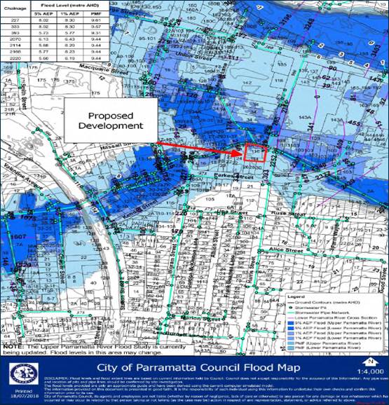
Source: Cardno Pty Ltd Flood Impact Assessment
PMF Event
To understand the likely warning times and associated response times during extreme flood events it is necessary to estimate the expected rate of rise of floodwaters.
At 114-118 Harris Street, Harris Park the estimated rate of rise of flooding in a PMF event at the ground floor entry and the driveway is around 2.5 m/hr. Features of the planned development include:
- Ground levels which vary from 8.49 m AHD in the southwest corner of 118 Harris Street to 5.74 m AHD in the in the vicinity of the northern boundary of the property;
- Proposed ground floor level for the commercial and retail outlets of 7.0 m AHD which provides which provides 0.45 m freeboard to the indicative 100 yr. ARI flood level under climate change;
- Proposed Level 1 floor level or the commercial uses of 11.2 m AHD which is higher than the PMF level;
- Proposed floor levels for all the apartments which are all significantly higher than the PMF level;
- A driveway crest level of around 7.0 m AHD which provides 0.81 m freeboard to the 100 yr. ARI flood level in Clay Cliff Creek and 0.45 m freeboard to the indicative 100 yr. ARI flood level under climate change in Clay Cliff Creek.
While the entry to the ground floor retail outlets has a freeboard of around 0.81 m above the current 100-year ARI flood level, this freeboard would be overwhelmed in a PMF event (within around 2 hours). The PMF is estimated to reach a level of around 9.44 m AHD.
Section 2 of the Parramatta DCP 2011 describes site planning considerations including design objectives, design principles and design controls. An assessment of the compliance of the proposed development with Council’s requirements is given in Section 7 of the Flood Assessment which is attached with this Planning Proposal.
It is concluded that the site is generally suitable for residential development from a flood risk perspective. The Planning Proposal is considered to be capable of being consistent with Section 4.3 Flood Prone Land of the Section 9.1 Ministerial Direction subject to inclusion of controls to be added to the Planning Proposal. These will require the development to address floodplain risk management in a manner consistent with the approach proposed in the Parramatta CBD Planning Proposal. The controls will require safe areas for refuge and ensure the building is capable of withstanding and does not obstruct flood flows.
Transport and Accessibility Assessment
A Traffic Impact Assessment (TIA) been prepared by TRAFFIX Pty Ltd and is attached with this Planning Proposal. The Traffic Report identifies changes to the cycle times and phase sequence of both traffic signals, that when implemented, would result in an overall improvement to the operation of the nearby intersections, even with the increased traffic generation from the proposed developments. Accordingly, the proposed changes to the timing cycle and phase sequence are recommended to Council for implementation, to ensure that the planning proposals do not impact on the existing level of services but have a net benefit.
The maximum parking requirements for the proposed developments have been provided in accordance with the City of Sydney Local Environmental Plan 2012 as required by Parramatta City Council for development within the Parramatta City Centre.
The vehicular access requirements for each development have been provided to ensure the proposed developments comply with AS2890.1 (2014). It is therefore concluded that the proposed development is supportable on traffic planning grounds and would operate satisfactorily.
The site is within proximity to the Stage 1 of the Parramatta Light Rail with a proposed light rail stop to be located at the Corner of Harris and Macquarie Streets which is a short 170m from the site. The Parramatta Light Rail is due to be opened in 2023 and will link the site to Parramatta’s CBD, Westmead Health Precinct, Parramatta North Urban Transformation Precinct, the new Western Sydney Stadium, a cultural hub including the Powerhouse Museum and Riverside Theatres, the private and social housing redevelopment of Telopea, Rosehill Gardens Racecourse, and three Western Sydney University campuses.
The Parramatta Light Rail is planned to be serviced from 5am to 1am, 7 days a week with services approximately every 7.5 minutes from 7am to 7pm weekdays.
The subject land achieves optimal access to pedestrian pathways, cycleways as well as light rail.
Both the Parramatta Light Rail and new bus and cycleways will deliver truly city shaping infrastructure which will powerfully change the way people live within Parramatta and commute to Parramatta. This will result in a significant lower reliance on private vehicle trips.
In addition, the draft Bike Plan supports the City of Parramatta’s Vision to be Sydney’s Central City, sustainable, liveable, and productive city. The plan seeks to brings forward the planned and coordinated delivery of cycleway infrastructure to promote multi-modal transport options throughout the City.
The Planning Proposal is required to take into consideration a provision on the Local Reservation Acquisition (LRA) Maps of the draft Parramatta CBD Planning Proposal that provides for local road widening on the western side of Harris Street. The width of the widening is approximately 3.5 metres. The widening has been incorporated into the strategic traffic modelling for the CBD Planning Proposal, and at this stage it has been jointly agreed by Transport for NSW and Council to facilitate the creation of a potential additional lane along the west side of Harris Street. Therefore, it has been included in the Local Reservation Acquisition Maps for the draft CBD Planning Proposal. This is discussed further in the section of this report relating to a Planning Agreement.
3.3.3. How has the planning proposal adequately addressed any social and economic effects?
The social and economic effects of the planning proposal are most appropriately described in the context of the challenges associated with a growing population as described in the State Government documents the Plan for Growing Sydney and a Metropolis of Three Cities. Among other things, the Plan explains that to meet the needs of a larger population and to maintain economic growth, urban renewal in combination with infrastructure delivery must occur in strategic urban centres.
As previously described, the objective of the planning proposal aligns closely with the strategic directions identified in the Plan for Growing Sydney and a Metropolis of Three Cities. The delivery of high-density housing in a location that is well serviced by infrastructure and where there are minimal existing environmental site constraints is considered to represent a positive social outcome. The planning proposal will facilitate future development that will result in higher population densities in Parramatta. In this regard, the planning proposal will support the emergence of Parramatta as Sydney’s second CBD which will in turn contribute to continued economic growth.
A key component of the preferred future development option for the subject site incorporates an area of public open space. The public open space will have excellent connectivity to public transport and will serve to promote healthy lifestyles and social interaction.
3.4. Section D – State and Commonwealth Interests
3.4.1. Is there adequate public infrastructure for the planning proposal?
The Parramatta CBD Strategy identifies this site as suitable for high density residential development due to its superior access to transport and employment opportunities in the Parramatta CBD. The site is located not only within the Parramatta CBD but also is within 700m walking distance to Parramatta train station and an 850-walking distance to Harris Park Train Station.
Given the proximity of the subject site to public transport services including bus services it is anticipated that a significant proportion of new residents would opt to use public transport rather than private vehicle.
The subject site is within the Parramatta CBD which has a variety of health, education and emergency services. In a broader context, the subject site is proximate to Westmead Hospital and the Western Sydney University which are regional institutions.
The Council has endorsed a value sharing mechanism as part of the Parramatta CBD Planning Proposal which is actualised through the floor space ratio controls proposed within the Parramatta CBD Planning Proposal. As discussed previously, there are incentives in terms of both building height and floor space ratio that can be utilised for this site which are linked to the provision of community infrastructure. The provisions require delivery of community infrastructure to the satisfaction of the consent authority, whether provided on the development site or an alternative site nominated by the consent authority. This planning proposal is supported by a letter which proposes to make a voluntary financial contribution consistent with the Phase 1 Value Sharing methodology that will provide contributions towards community infrastructure
3.4.2. What are the views of State and Commonwealth public authorities consulted in accordance with the gateway determination?
Consultation with the State and Commonwealth public authorities will be undertaken once the gateway determination has been issued.
This section contains the mapping for this planning proposal in accordance with the DP&E’s guidelines on LEPs and Planning Proposals.4.1 Existing controls
This section illustrates the current PLEP 2011 controls which apply to the site.
![]()
Figure2 – Existing zoning extracted from Parramatta LEP 2011 Land Zoning Map
Figure 2 illustrates the existing zone over the site.
![]()
Figure 3 – Existing building heights extracted from the Parramatta LEP 2011 Height of Buildings Map
Figure 3 illustrates the existing building height over the site.
Figure 4 – Existing floor space ratio extracted from the Parramatta LEP 2011 Floor Space Ratio Map
Figure 4 illustrates the existing the FSR over the site.
The figures in this section illustrate the proposed amendments to the maximum building height and floor space ratio maps as a result of the assessment and recommendations for the planning proposal.
[proposed building height map to be inserted prior to exhibition]
Figure 4 – Proposed amendment to the Parramatta LEP 2011 Height of Building Map
Figure 4 above illustrates the proposed building height of 126 metres over the site. The proposed height excludes the additional 15% of GFA (which equates to a total height of 145 metres) as this will be achieved through via the design excellence clause at development application stage.
[proposed floor space ratio map to be inserted prior to exhibition]
Figure 5 – Proposed amendment to the Parramatta LEP 2011 Floor Space Ratio Map
Figure 5 above illustrates the proposed 10:1 FSR over the site. This excludes the additional 15% of GFA (this equates to a total FSR of 11.362:1, which also reflects the application of the sliding scale provision) as this will be achieved through the forthcoming design excellence clause at development application stage.
PART 5 – COMMUNITY CONSULTATION
The planning proposal (as revised to comply with the Gateway determination) is to be publicly available for community consultation.
Public exhibition is likely to include:
· newspaper advertisement;
· display on the Council’s web-site; and
· written notification to adjoining landowners.
The gateway determination will specify the level of public consultation that must be undertaken in relation to the planning proposal including those with government agencies.
Consistent with sections 3.34(4) and 3.34(8) of the EP&A Act 1979, where community consultation is required, an instrument cannot be made unless the community has been given an opportunity to make submissions and the submissions have been considered.
Once the planning proposal has been referred to the Minister for review of the Gateway Determination and received a Gateway determination, the anticipated project timeline will be further refined, including at each major milestone throughout the planning proposal’s process.
Table 7 below outlines the anticipated timeframe for the completion of the planning proposal.
Table 7 – Anticipated timeframe to planning proposal process
|
MILESTONE |
ANTICIPATED TIMEFRAME |
|
Report to LPP on the assessment of the PP |
June 2020 |
|
Report to Council on the assessment of the PP |
July 2020 |
|
Referral to Minister for review of Gateway determination |
August 2020 |
|
Date of issue of the Gateway determination |
October 2020 |
|
Commencement and completion dates for public exhibition period |
November – December 2020 |
|
Commencement and completion dates for government agency notification |
December 2020 |
|
Consideration of submissions |
January 2021 |
|
Consideration of planning proposal post exhibition and associated report to Council |
February 2021 |
|
Submission to the Department to finalise the LEP |
March 2021 |
|
Notification of instrument |
April 2021 |
Appendix 1 – Revised Reference Design