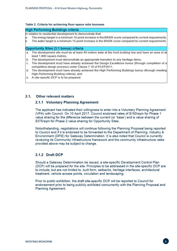
|
Item 5.1 - Attachment 1 |
Attachment 1: Assessment Report & Conditions |
NOTICE OF Local Planning Panel MEETING
PUBLIC AGENDA
An Ordinary Local Planning Panel will be held remotely via audio-visual link, Tuesday, 19 May 2020 at 3.30pm.
Brett Newman
CHIEF EXECUTIVE OFFICER
THIS PAGE LEFT BLANK INTENTIONALLY
Local Planning Panel 19 May 2020
TABLE OF CONTENTS
ITEM SUBJECT PAGE NO
1 ACKNOWLEDGMENT OF THE TRADITIONAL LAND OWNERS
The City of Parramatta Council acknowledges the Burramattagal Clan of The Darug, the traditional land owners of Parramatta and pays its respects to the elders both past and present
2 WEBCASTING ANNOUNCEMENT
This public meeting will be recorded. The recording will be archived and available on Council’s website.
All care is taken to maintain your privacy; however if you are in attendance in the public gallery, you should be aware that your presence may be recorded.
3 APOLOGIES
4 DECLARATIONS OF INTEREST
5 Reports - Development Applications
5.1 458 Church Street, Parramatta............................................................... 6
5.2 38 Junction Road, Winston Hills (Lot 198 DP 235090).................. 112
5.3 Shop 1/1 Baywater Drive, Wentworth Point (Lot 0 SP 85179)..... 135
6 Innovative
6.1 Planning Proposal for 85-91 Thomas Street, Parramatta.............. 168
6.2 Planning Proposal - 8-14 Great Western Highway, Parramatta... 282
6.3 Post-exhibition: Planning Proposal, draft site-specific Development Control Plan and draft Planning Agreement at 55 Aird Street, Parramatta 367
Development Applications
19 May 2020
5.1 458 Church Street, Parramatta........................................................................ 6
5.2 38 Junction Road, Winston Hills (Lot 198 DP 235090)........................... 112
5.3 Shop 1/1 Baywater Drive, Wentworth Point (Lot 0 SP 85179)............... 135
Local Planning Panel 19 May 2020 Item 5.1
ITEM NUMBER 5.1
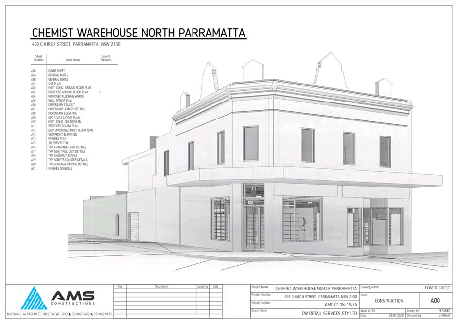
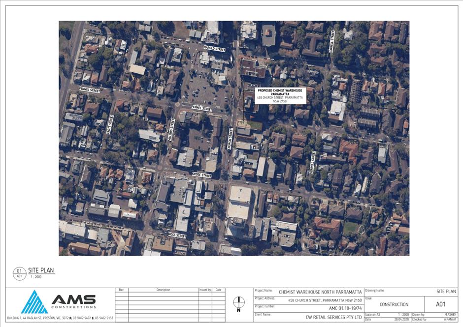
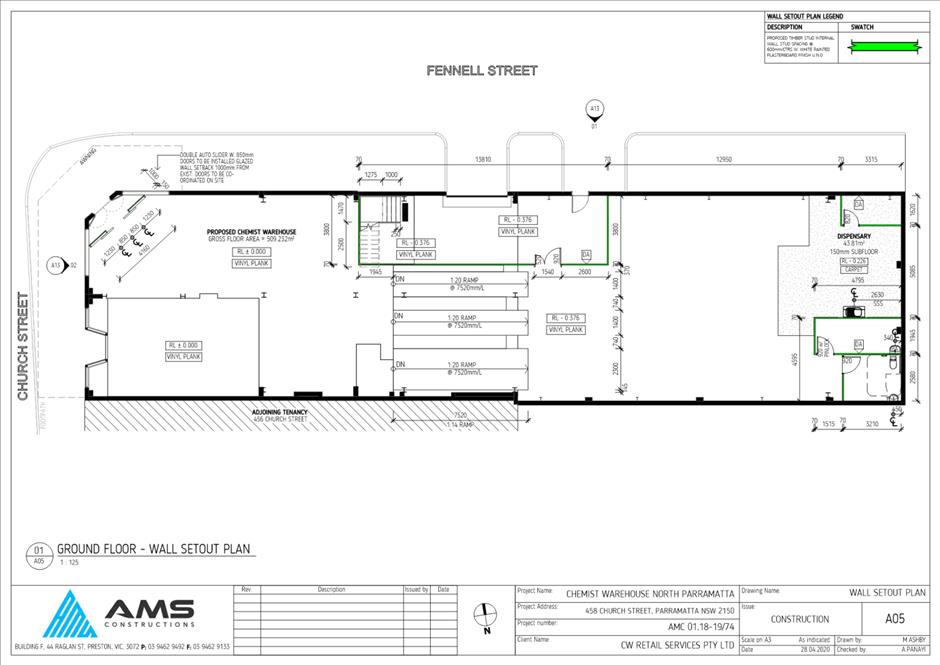
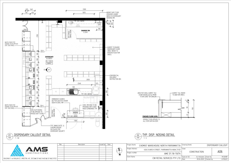
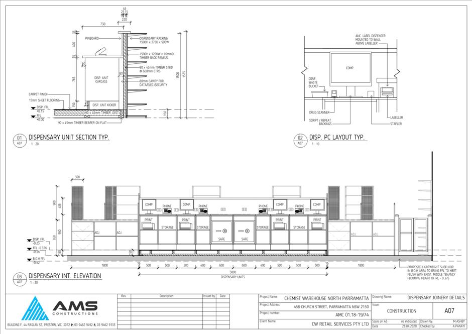
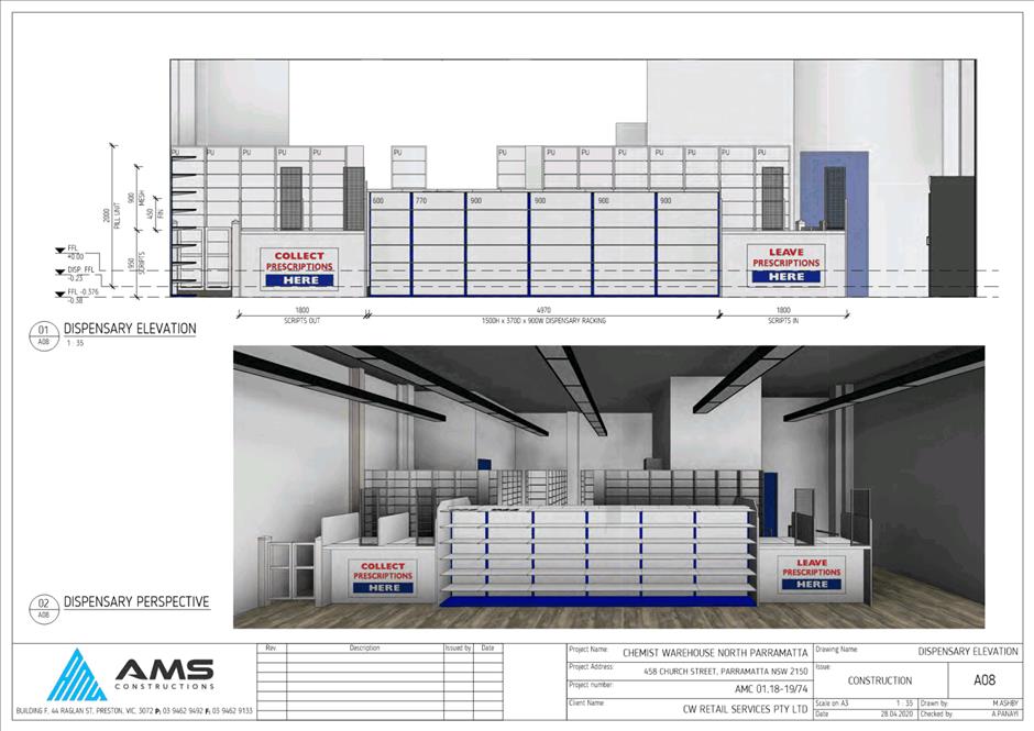
SUBJECT 458 Church Street, Parramatta
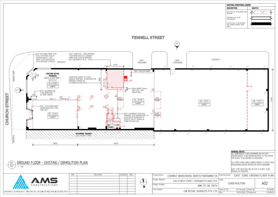
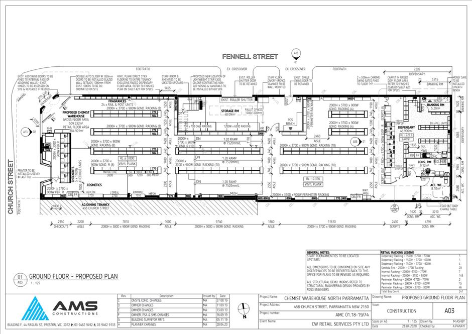
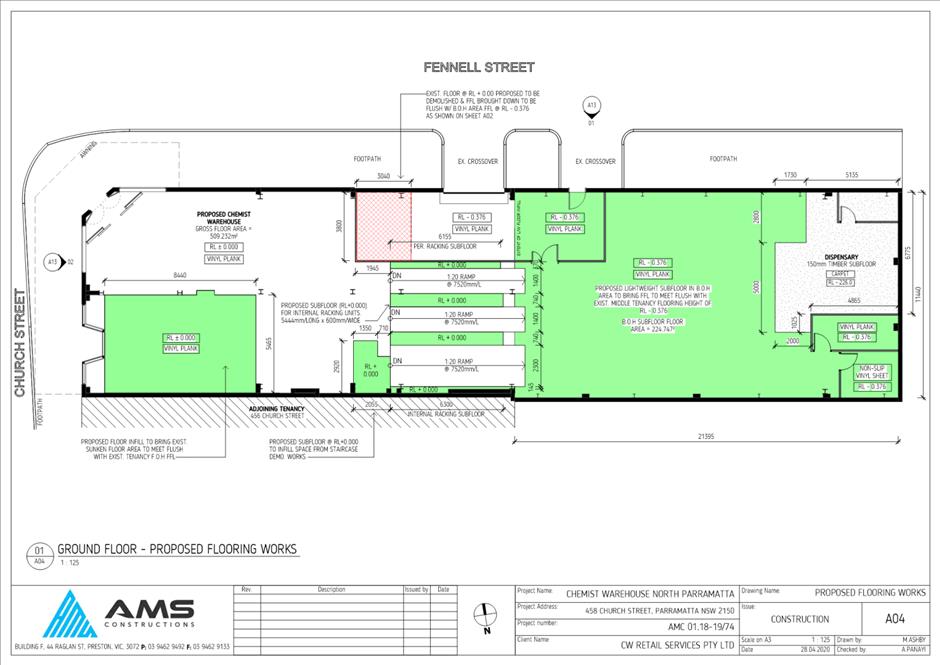
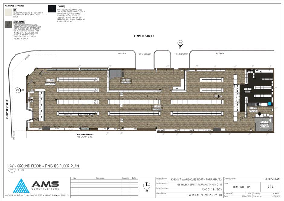
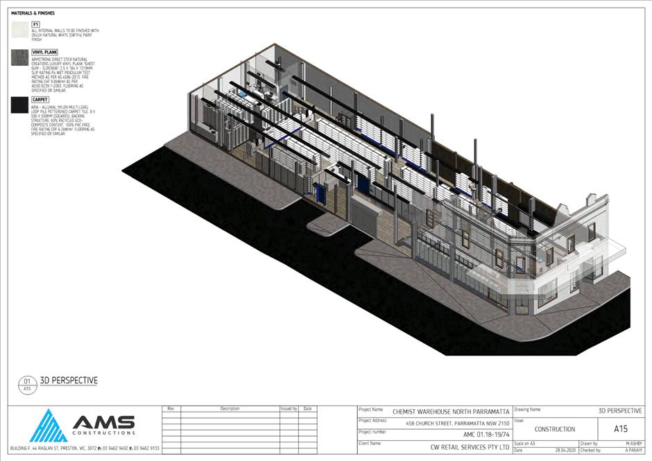
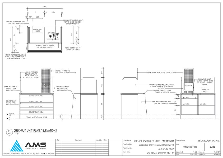
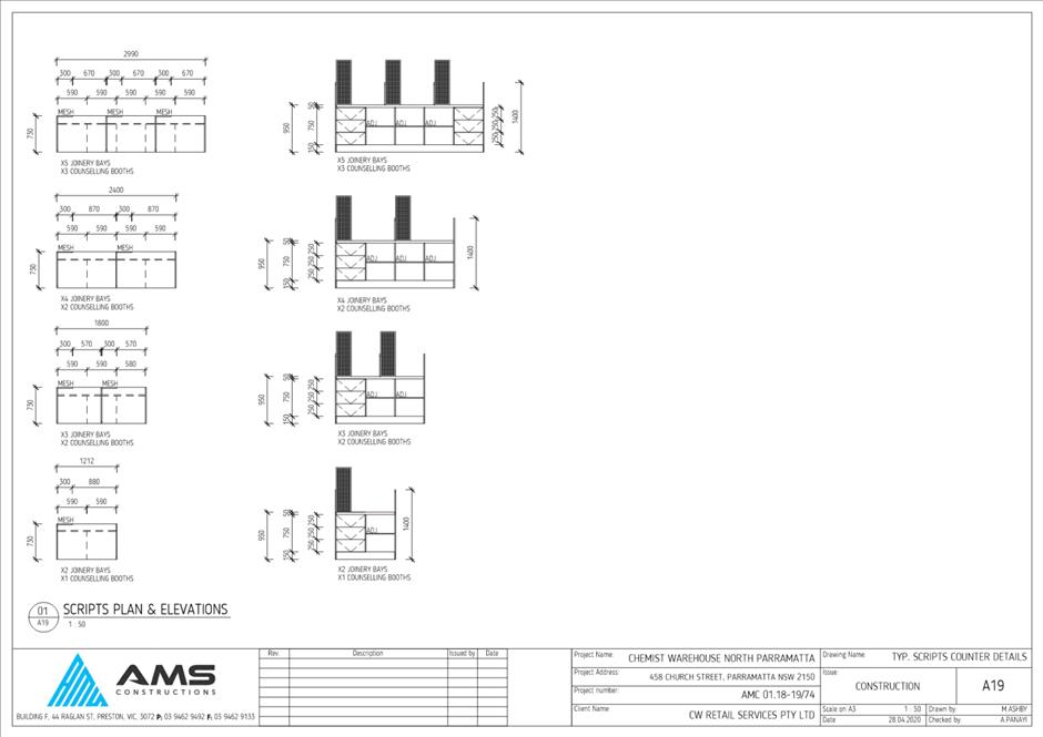
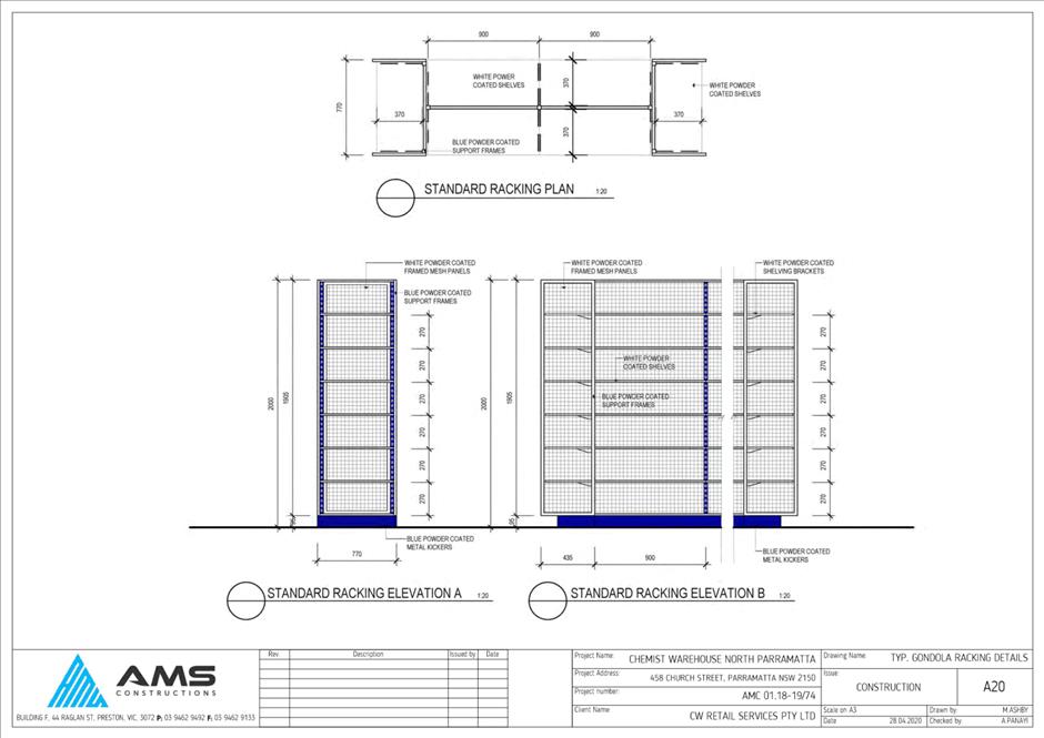
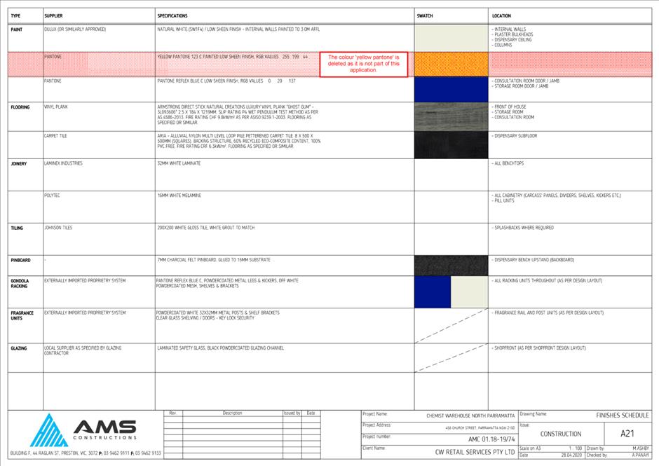
DESCRIPTION Fit out and use of an existing shop for the purposes of a chemist.
REFERENCE DA/27/2020 -
APPLICANT/S Mr A Caladine
OWNERS Ms K S L Loo & Mr T H Ng
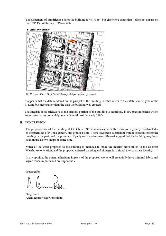
REPORT OF Group Manager Development and Traffic Services
|
DATE OF REPORT 19 may 2020
REASON FOR REFERRAL TO LPP
In accordance with Schedule 2 of the Local Planning Panels Direction for Development Applications 2018, the subject application is required to be determined by the Parramatta Local Planning Panel (PLPP) as more than ten (10) unique submissions by way of objection have been received.
EXECUTIVE SUMMARY
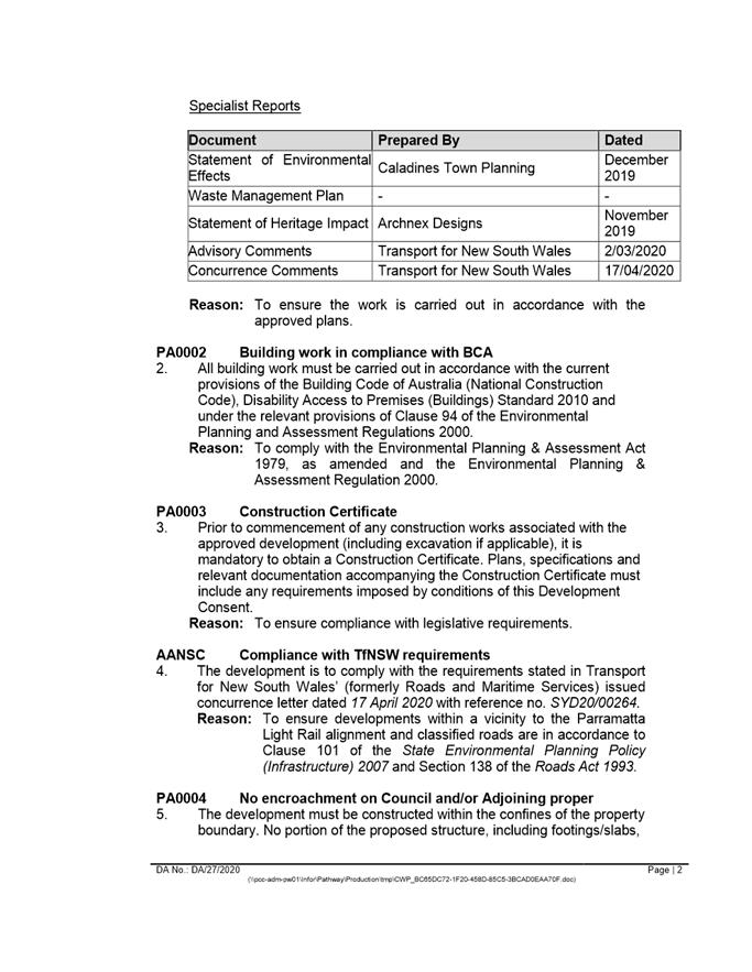
This is a summary of the full assessment of the application as outlined in Attachment 1, the Section 4.15 Assessment Report.
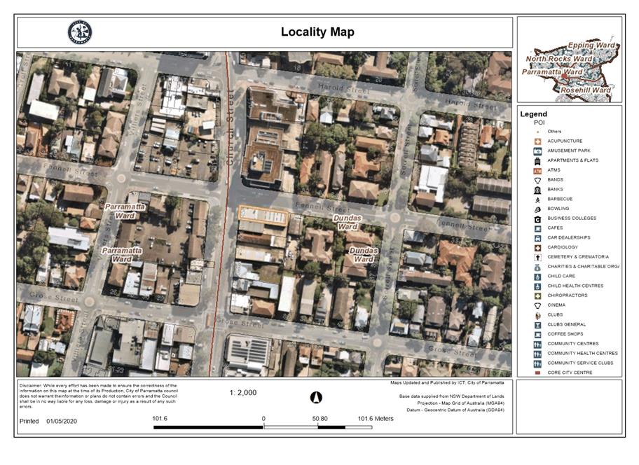
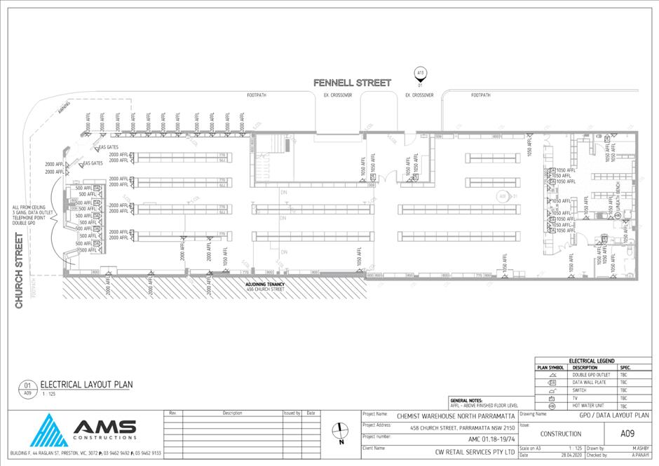
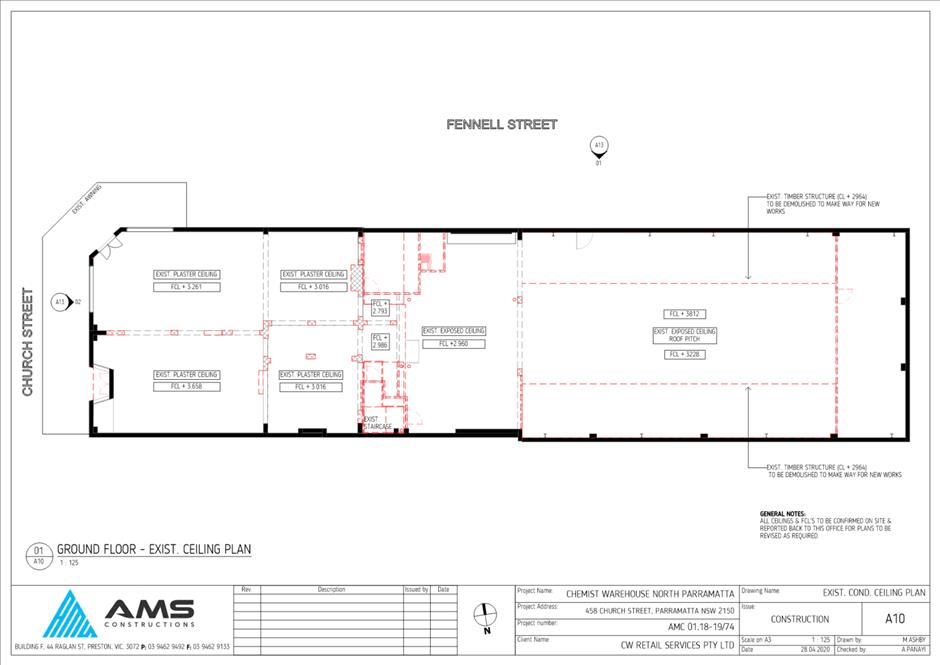
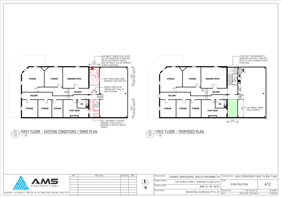
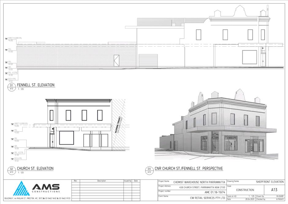
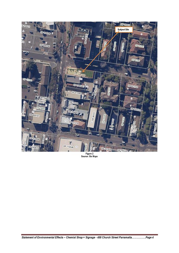
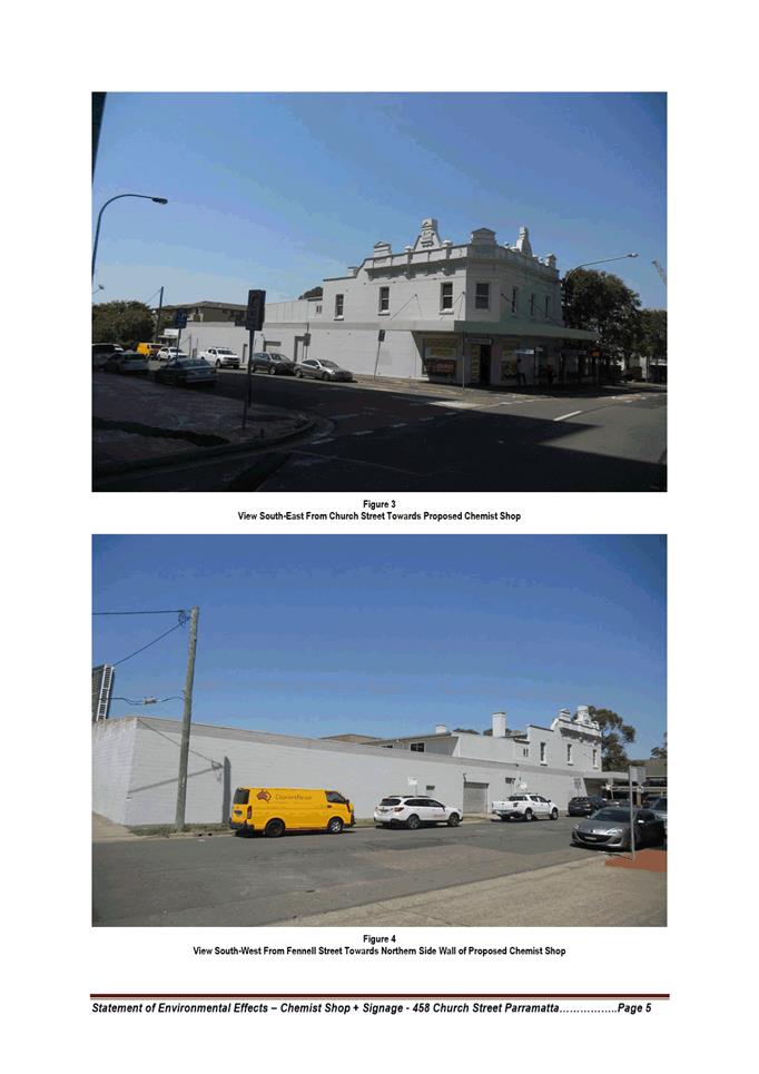
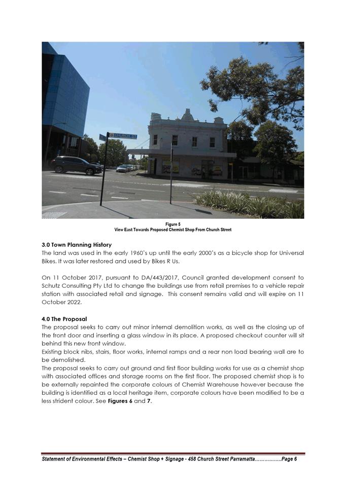
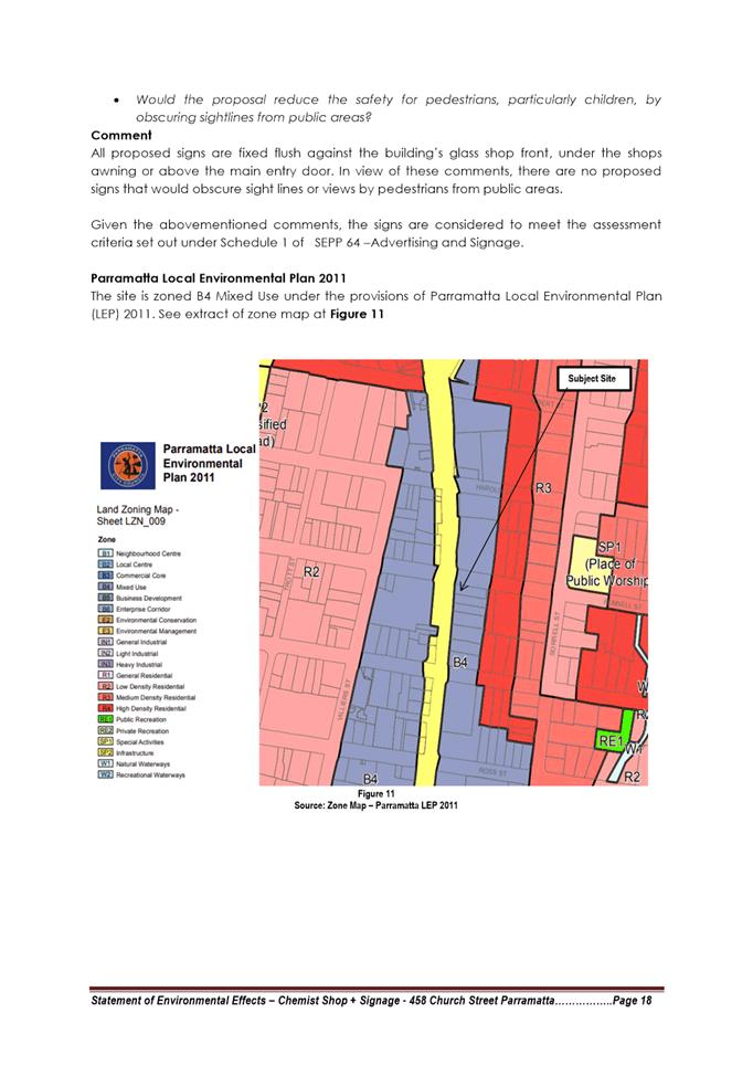
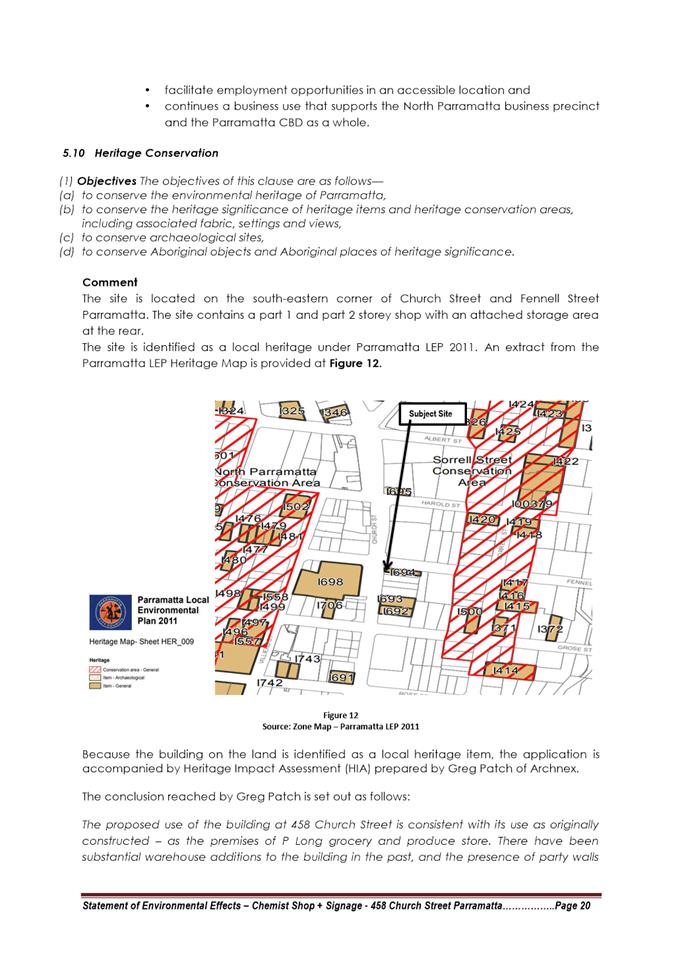
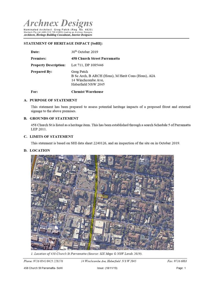
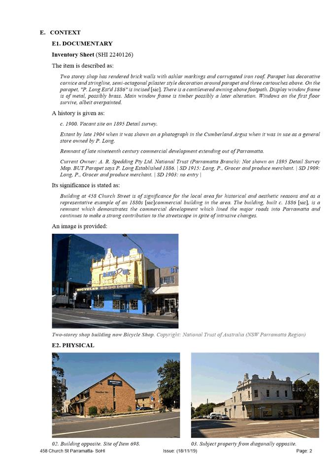
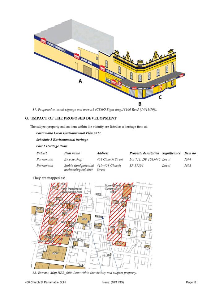
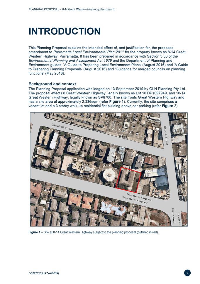
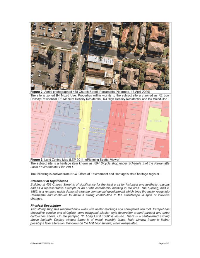
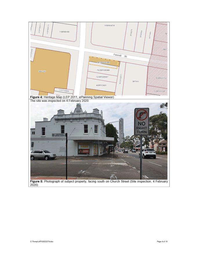
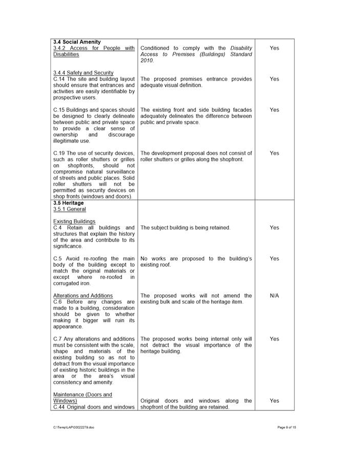
SITE The site is known as 458 Church Street Parramatta. The subject property is identified as a heritage item known as I694 Bicycle shop under Schedule 5 of the Parramatta Local Environmental Plan 2011 (PLEP 2011).
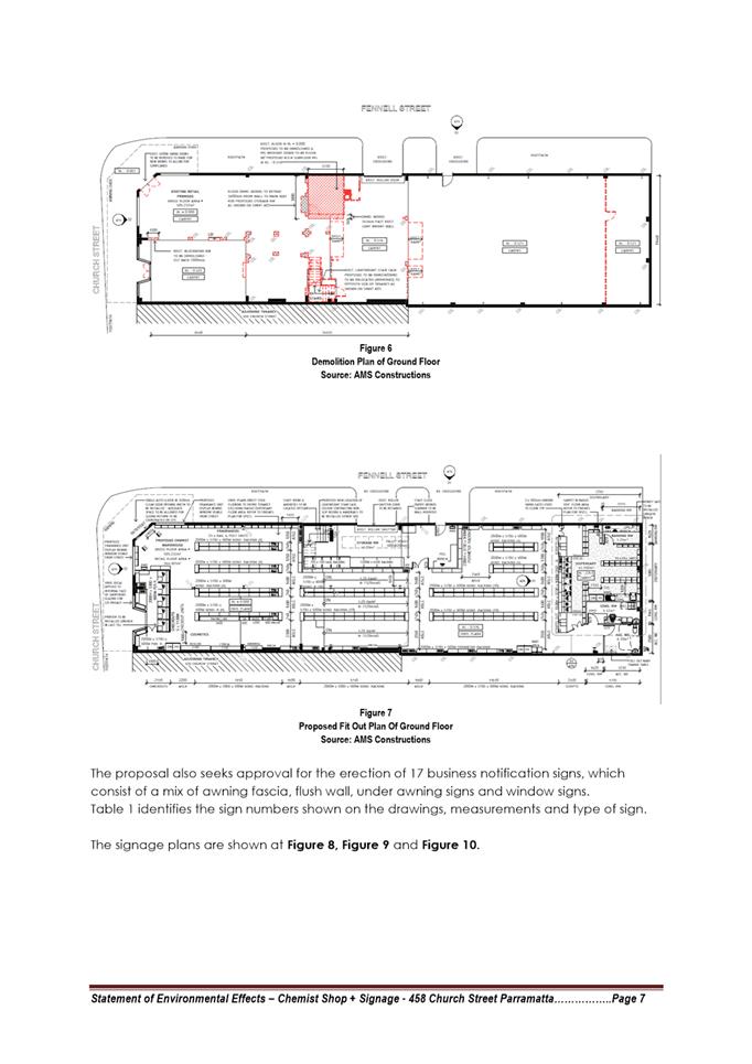
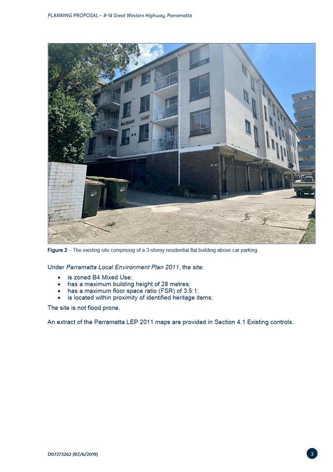
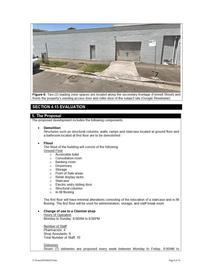
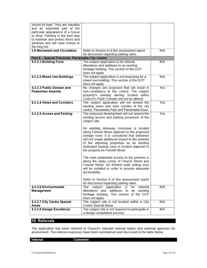
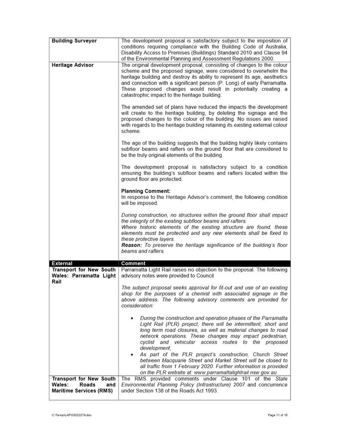
THE PROPOSED DEVELOPMENT The subject application is for the fit out and use of an existing shop for the purposes of a chemist. The proposal was reviewed by Council’s Heritage Advisor and no objections were raised to the amended proposal, subject to the imposition of appropriate conditions of consent. The application has been assessed against the relevant environmental planning instruments, regulations and the Parramatta Development Control Plan (DCP) 2011, and found to be generally be in compliance.
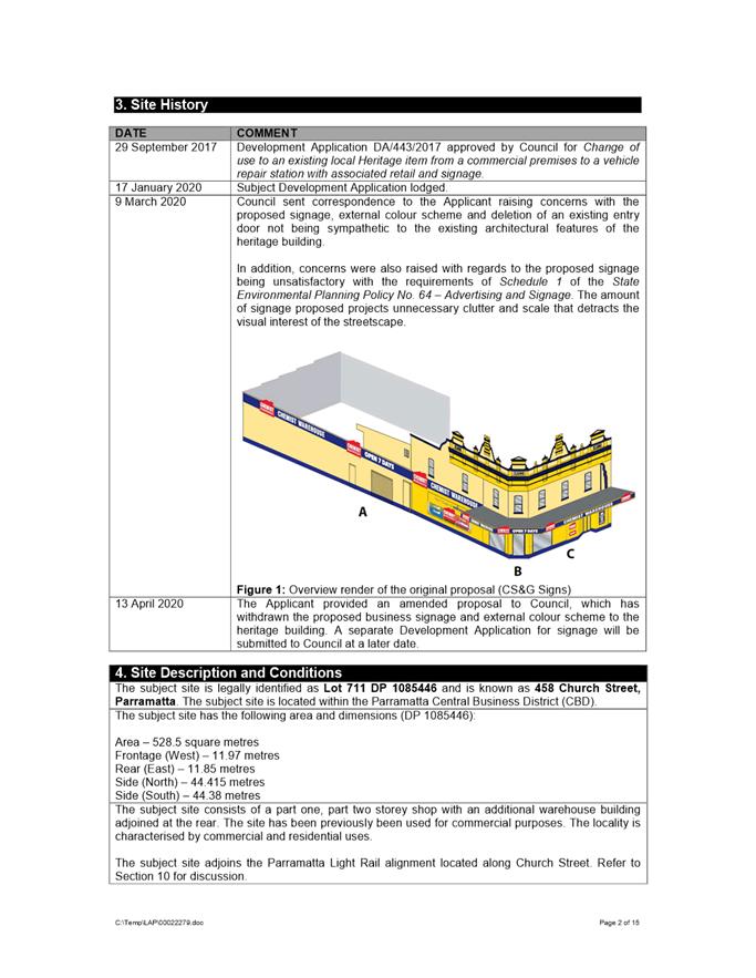
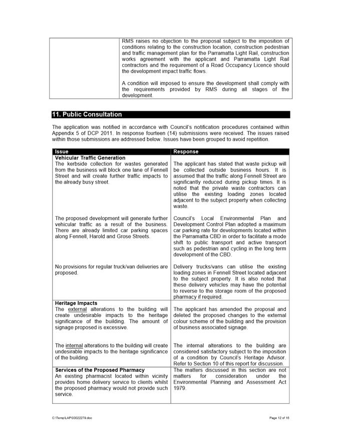
The application was advertised in accordance to the requirements within PDCP 2011. Fourteen (14) objections were received during the consultation period. The issues raised in the objections related to traffic, impacts to the heritage building, nature of the business, character, business competition, acoustic impacts and the generation of criminal activity.
With respect to the issues and matters addressed in detail within Attachment 1, the application is recommended for approval.
|
|
(a) That the Parramatta Local Planning Panel (PLPP), exercising the functions of Council, pursuant to Section 4.16 of the Environmental Planning and Assessment Act 1979, grant development consent to DA/27/2020 for a period of five (5) years within which physical commencement is to occur from the date on the Notice of Determination, subject to conditions of consent at Attachment 1.
(b) Further, that the submitters be advised of the Panel’s decision.
|
John Martinez
Development Assessment Officer
|
1⇩ |
Attachment 1: Assessment Report & Conditions |
30 Pages |
|
|
2⇩ |
Attachment 2: Locality Map |
1 Page |
|
|
3⇩ |
Attachment 3: Plans used during assessment |
24 Pages |
|
|
4⇩ |
Attachment 4: Statement of Environmental Effects |
27 Pages |
|
|
5⇩ |
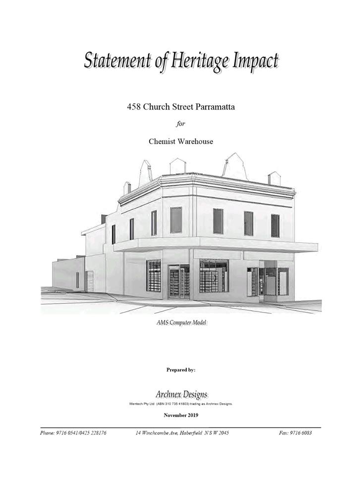
Attachment 5: Statement of Heritage Impact |
19 Pages |
|
|
6⇩ |
Attachment 6: Transport for New South Wales Concurrence Letter |
3 Pages |
|
REFERENCE MATERIAL
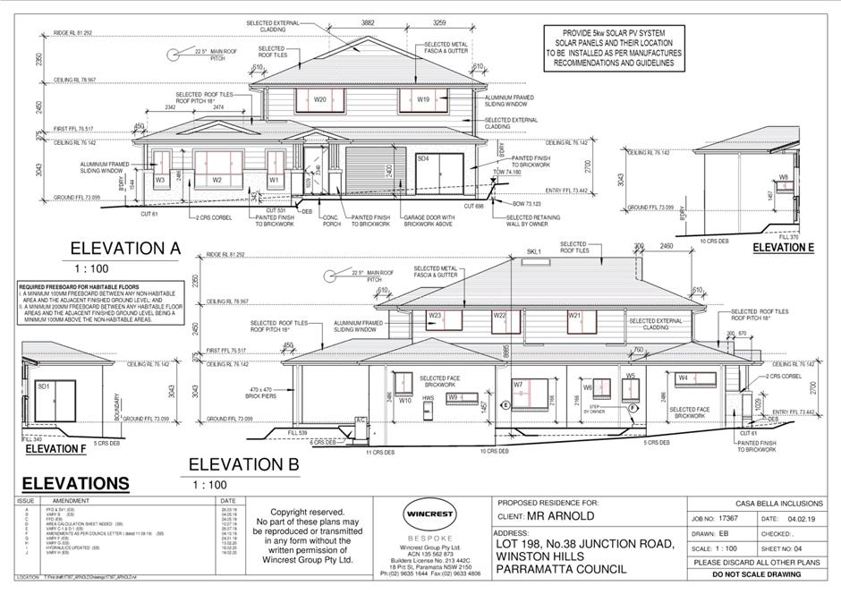
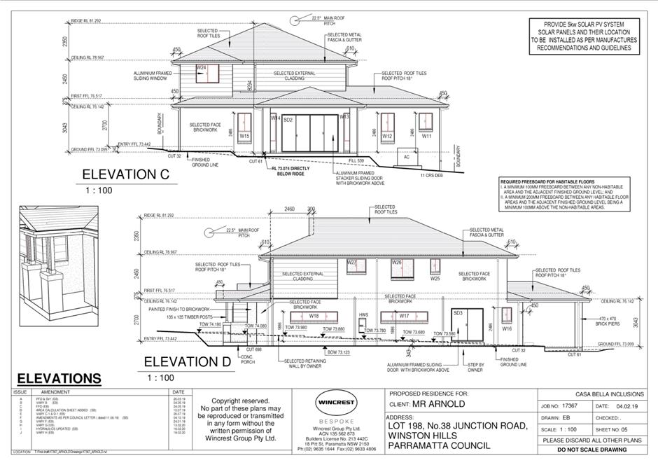
ITEM NUMBER 5.2
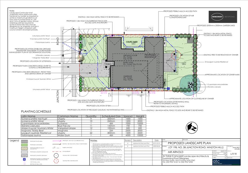
SUBJECT 38 Junction Road, Winston Hills (Lot 198 DP 235090)
DESCRIPTION Section 8.2 Review of Determination of the refusal of DA/465/2019 for the demolition of existing structures and construction of a two-storey dwelling with a double garage.
REFERENCE DA/465/2019 -
APPLICANT/S Sina Camilleri
OWNERS Barbara Arnold
REPORT OF Group Manager Development and Traffic Services
|
DATE OF REPORT 7 April 2020
REASON FOR REFERRAL TO LPP
The subject application is referred to Parramatta Local Planning Panel as the applicant has lodged a Review of Determination pursuant to Section 8.2 of the Environmental Planning and Assessment Act 1979.
EXECUTIVE SUMMARY
This is a summary of the assessment of the application as outlined in attachment 1, the Section 8.2 Review Assessment Report.
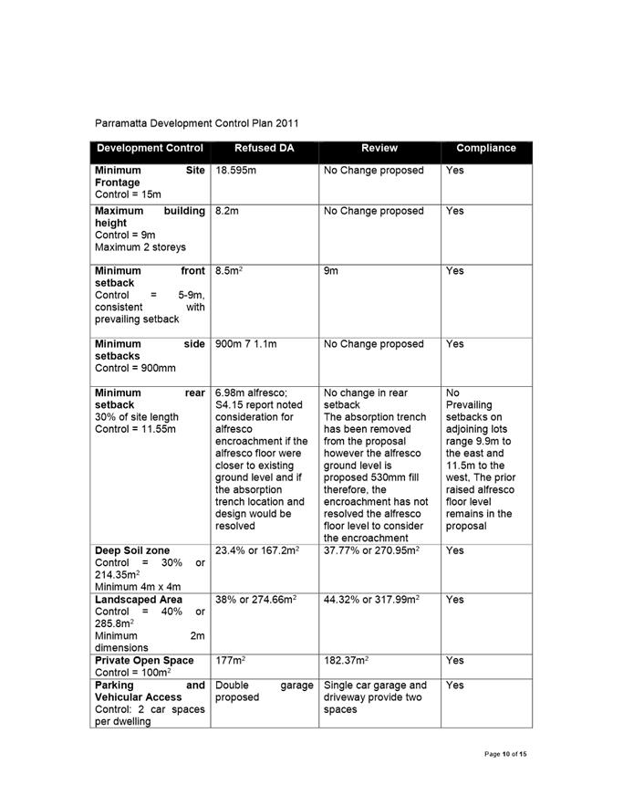
The subject application is for a Review of Determination of DA/465/2019, which was refused under delegated authority for the demolition of existing structures and construction of a two storey dwelling with a double garage.
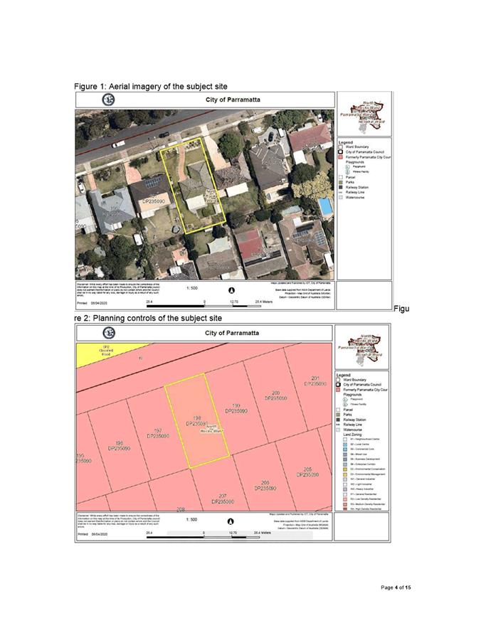
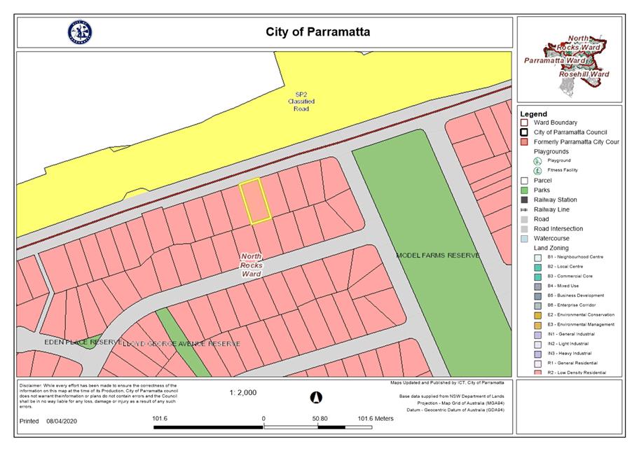
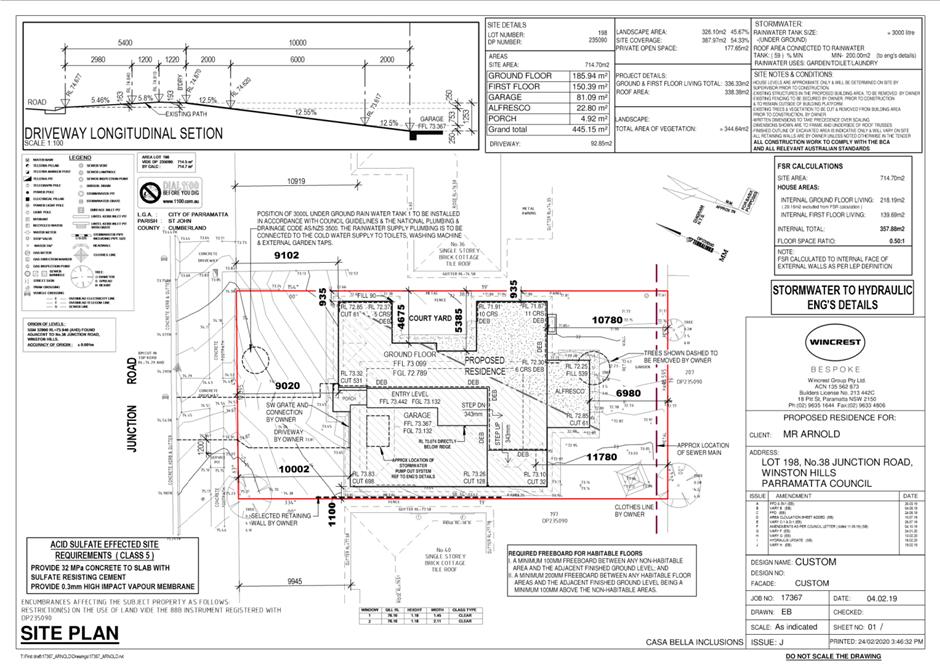
This subject site is known as Lot 198 in DP 235090, No.38 Junction Road, Winston Hills. The site is zoned R2 Low Density Residential under the Parramatta Local Environmental Plan 2011. The proposal is for the purposes of a dwelling house which is permitted with consent.
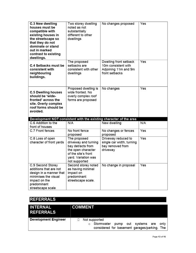
The site is located within the Winston Hills Special character Area characterised by single and two storey residential dwellings with single storey dwellings on the immediately adjoining lots.
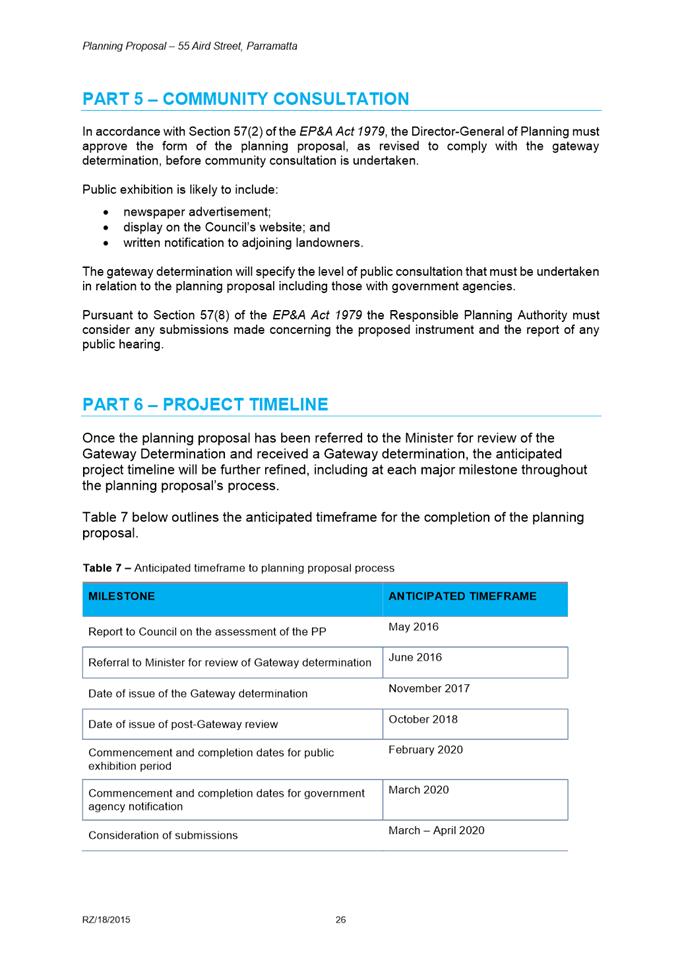
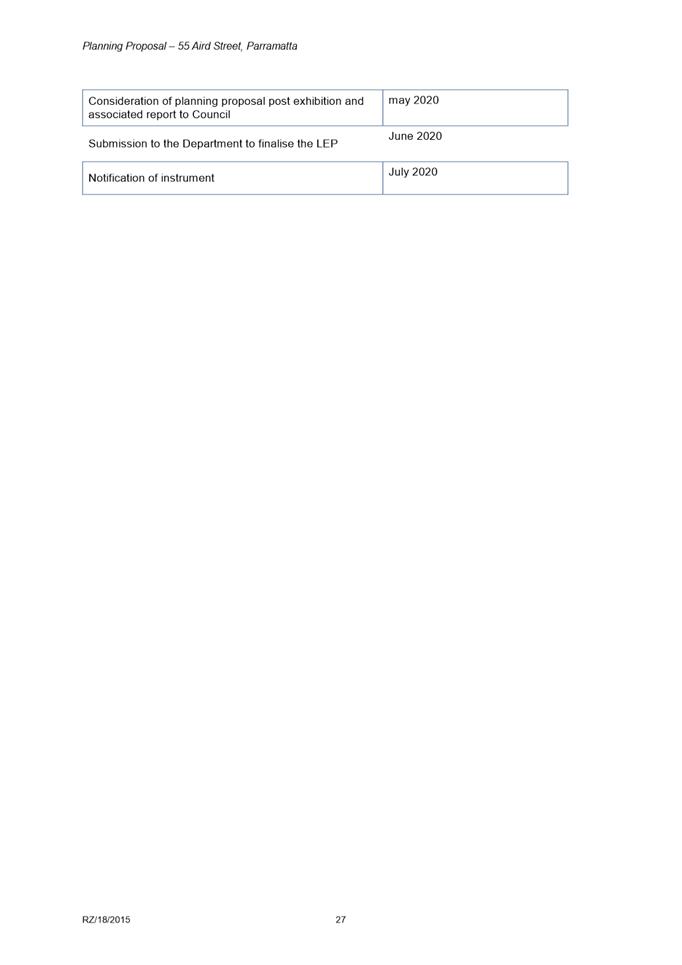
The application was refused under delegated authority on 15 November 2019 for the following reasons:
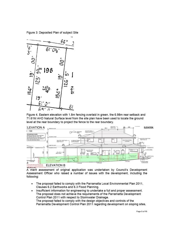
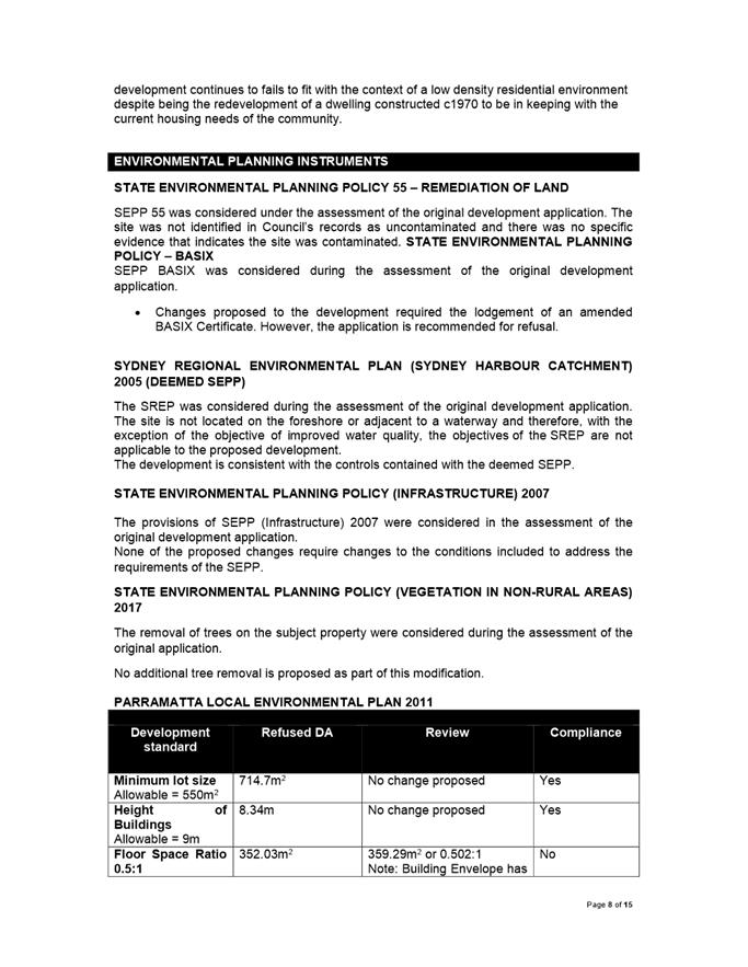
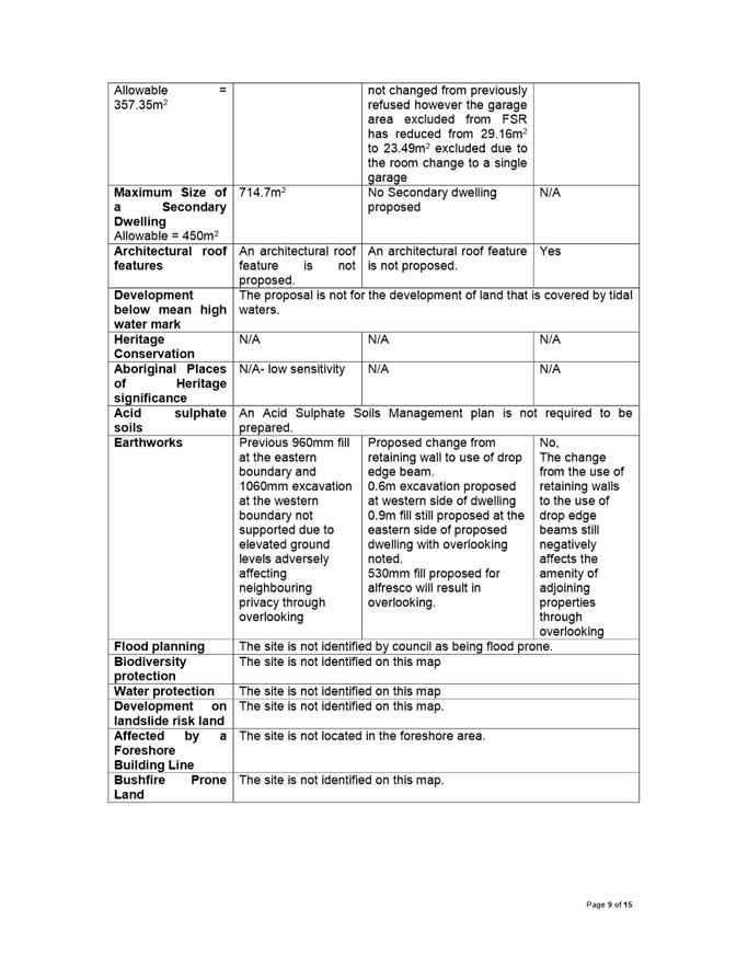
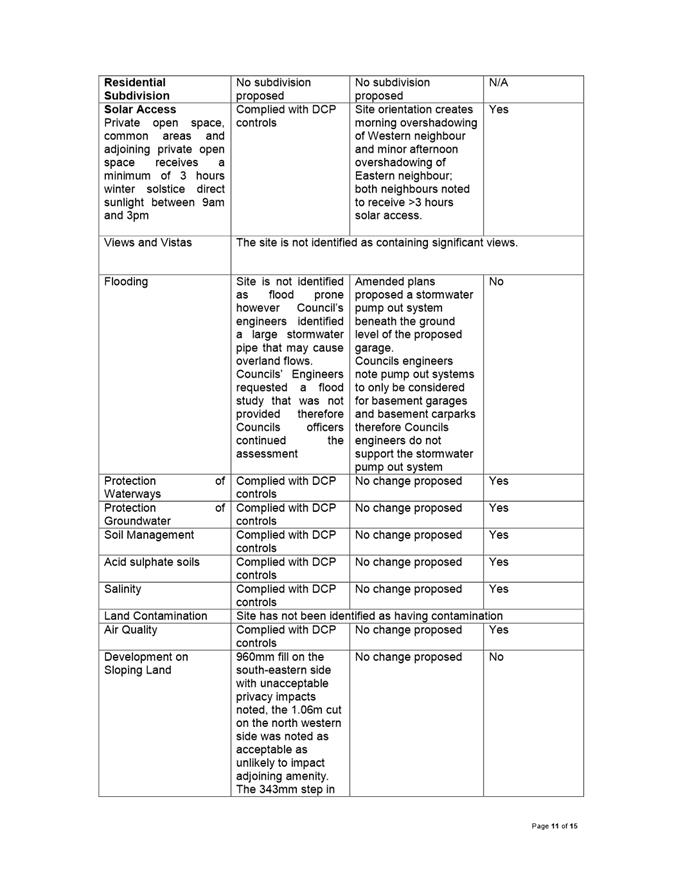
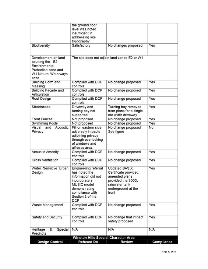
1. In accordance with Section 4.15(1) (a) (i) of the Environmental Planning and Assessment Act 1979, the proposal fails to achieve the objectives of the R2 Low Density Residential zone. 2. In accordance with Section 4.15(1)(a)(i) of the Environmental Planning and Assessment Act 1979, the proposal fails to comply with the Parramatta Local Environmental Plan 2011 with respect to Clause 6.2 Earthworks and Clause 6.3 Flood Planning. 3. In accordance with Section 4.15(1)(a)(iii) of the Environmental Planning and Assessment Act 1979, the proposal fails to comply with the Parramatta Development Control Plan 2011 with respect to development on sloping sites, visual privacy, streetscape, vehicle access and parking, landscaping, water sensitive urban design deep-soil zone and Winston Hills special character area provisions. 4. Insufficient information was provided to undertake a full and proper assessment in accordance with Section 4.15(1) (a) (iii) of the Environmental Planning and Assessment Act 1979, the proposal does not achieve the requirements of the Parramatta Development Control Plan 2011 with respect to Stormwater Drainage. 5. In accordance with Section 4.15(1)(e) of the Environmental Planning and Assessment Act 1979, the proposal is not in the public interest. This Review of Determination application was lodged with Council on 10 March 2020. The application included amendments to the proposal, mainly relating to stormwater disposal, vehicle access and maneuvering and some structural changes to the construction of the dwelling. The proposal is considered substantially the same as the originally determined application.
An assessment of the amendments made has raised the following issues:
· The proposed floor levels and alfresco levels have the potential to adversely impact adjoining privacy through overlooking; · Council’s Development Engineering Team do not support the proposed stormwater pump out system; · No amendments have been made to the proposed fill on site and therefore remain non-compliant with the Parramatta Local Environmental Plan 2011; · The ground levels and fill do not comply with the Parramatta Development Control Plan 2011, Part 2.4.6 as the proposal does not respond to the topography of the site; · The rear alfresco is proposed with approximately 530mm fill resulting in overlooking as well a rear setback below the minimum 30% of the length of the site; · The proposal previously exhibited a Floor Space Ratio (FSR) of 0.492:1 however with the proposed amendment to a single car garage reducing the excluded area from the FSR calculation, the amended plans propose a dwelling with an FSR of 0.502:1. A written statement seeking a variation pursuant to Clause 4.6 Parramatta Local Environmental Plan 2011 did not accompany the review application; and · The setbacks proposed do not comply with control C.4 of part 4.2.4 of the Parramatta Development Control Plan 2011 with regard to the Winston Hills Special Character Area.
The application was notified in accordance with Council’s notification procedures contained within Parramatta Development Control Plan 2011 from 23 March 2020 to 6 April 2020. In response, no submissions received in respect to the proposal.
Having regard to the above, the review of determination has been concluded and it is recommended that the Parramatta Local Planning Panel uphold Council’s decision and refuse the application.
|
|
Pursuant to Section 8.3 of the Environmental Planning and Assessment Act, 1979:
(a) That the Parramatta Local Planning Panel, exercising the functions of Council as a consent Authority uphold Council’s decision to refuse development consent to DA/465/2019 for demolition of existing structures and construction of a two storey dwelling with an attached garage at 38 Junction Road, Winston Hills for the following reasons
1. In accordance with Section 4.15(1)(a)(i) of the Environmental Planning and Assessment Act 1979, the proposal fails to achieve the objectives of the R2 Low Density Residential zone.
2. In accordance with Section 4.15(1)(a)(i) of the Environmental Planning and Assessment Act 1979, the proposal fails to comply with the Parramatta Local Environmental Plan. With respect to Clause 4.4 for Floor Space Ratio, 6.2 Flood Planning and Clause 6.3 Earthworks.
3. In accordance with Section 4.15 (1) (a) (iii) of the Environmental Planning and Assessment Act 1979, the proposal fails to comply with the objectives and design principles of part 2.4.6 of the Parramatta Development Control Plan 2011, which requires the design of dwellings to sensitively respond to the topography of the site.
4. In accordance with Section 4.15 (1) (a) (iii) of the Environmental Planning and Assessment Act 1979, the proposal fails to comply with the controls of part 3.1.3 of the Parramatta Development Control Plan 2011, which requires dwellings to have a rear setback that is a minimum 30% of the length of the site.
5. In accordance with Section 4.15 (1) (a) (iii) of the Environmental Planning and Assessment Act 1979, the proposal fails to comply with the Parramatta Development Control Plan 2011, part 3.3.6 with regard to Water Sensitive Urban Design.
6. In accordance with Section 4.15 (1) (a) (iii) of the Environmental Planning and Assessment Act 1979, the proposal fails to comply with the objectives and design principles of part 3.3.3 of the Parramatta Development Control Plan 2011, which requires the design of dwellings to ensure that development does not cause unreasonable overlooking of habitable rooms and principle private open spaces of dwellings. |
Michael Stephen
Development Assessment Officer
|
1⇩ |
Attachment 1: Review Assessment Report |
15 Pages |
|
|
2⇩ |
Attachment 2: Locality Map |
1 Page |
|
|
3⇩ |
Attachment 3: Plans used during assessment |
4 Pages |
|
|
Attachment 4: Internal plans used during assessment (confidential) |
3 Pages |
|
REFERENCE MATERIAL
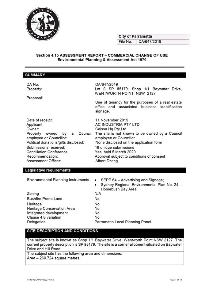
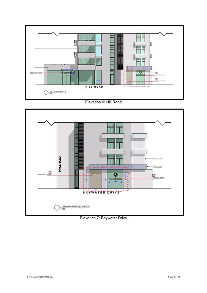
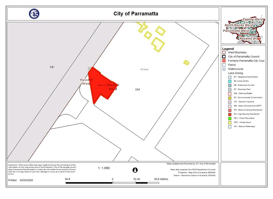
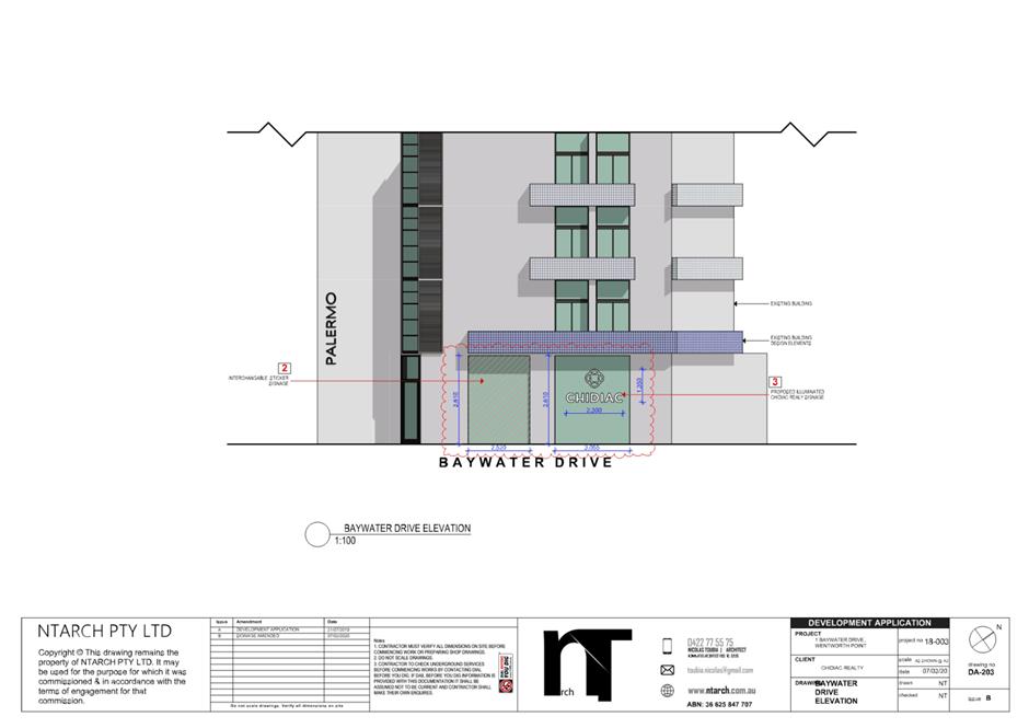
ITEM NUMBER 5.3
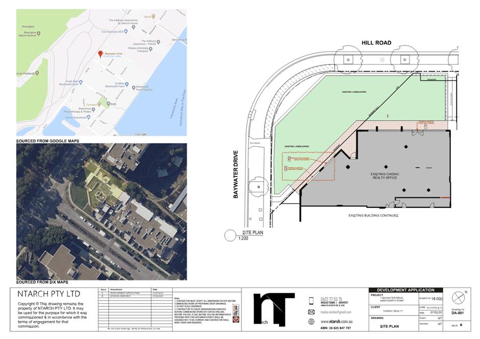
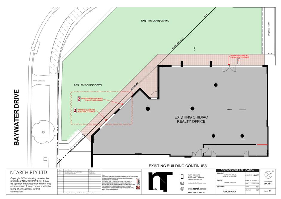
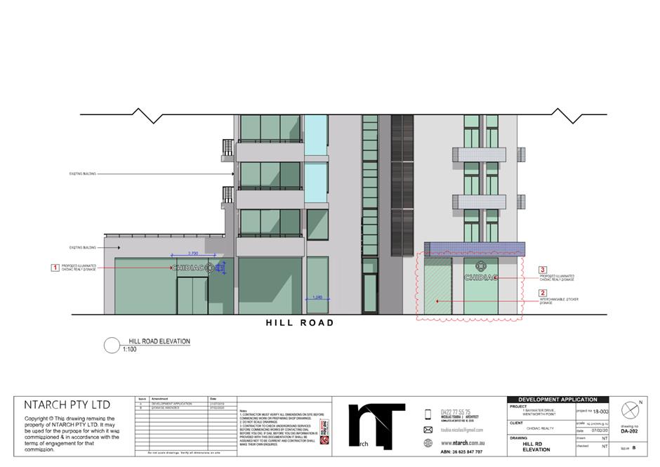
SUBJECT Shop 1/1 Baywater Drive, Wentworth Point (Lot 0 SP 85179)
DESCRIPTION Use of tenancy for the purposes of a real estate office and associated business identification signage.
REFERENCE DA/647/2019 -
APPLICANT/S AC INDUSTRIA PTY LTD
OWNERS Caissa Hq Pty Ltd
REPORT OF Group Manager Development and Traffic Services
|
DATE OF REPORT 8 April 2020
REASON FOR REFERRAL TO LPP
The application is referred to the Parramatta Local Planning Panel as the subject application received 16 unique submissions during two separate notification periods.
EXECUTIVE SUMMARY
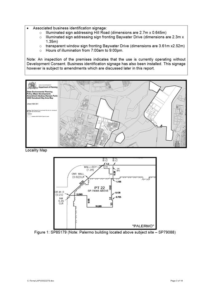
The subject site is known as No.1 Baywater Drive, Wentworth Point in Lot 0 SP 85179.
The subject development site is located within unzoned land under Sydney Regional Environmental Plan No. 24 – Homebush Bay Area.
The surrounding area is characterised with recently constructed mixed use developments. The subject site is located on the corner of Hill Road and Baywater Drive. The premises is located on the ground floor of a mixed use residential building named ‘Palermo.’
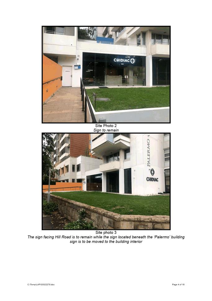
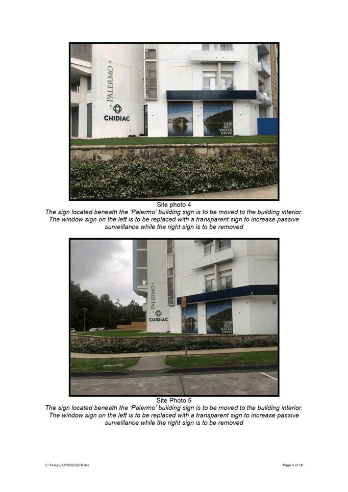
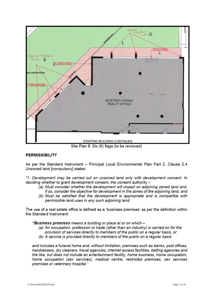
It should be noted that the use of the premises and the erection of the business identifcation signage has already commenced.
The proposal involves the use of tenancy as a real estate office and installation of associated business identification signs.
The proposed hours of operation for the business are seven (7) days a week from 8:00am to 6:00pm. The hours of illumination of business identification signs are seven (7) days a week from 7:00am to 9:00pm.
The original application and the amended application were advertised in accordance with Auburn Development Control Plan 2010. During this time, 16 individual submissions were received. The issues raised within the submissions include but are not limited to:
· Strata approval; · Signage approval; · Illumination; · Size of signs; · Cluttering; · Visual amenity; and · Hours of operation.
A Conciliation Meeting was held on the 5 March 2020, between the applicant, staff, objectors and Councillor Prociv.
The proposal has been assessed against the matters for consideration outlined in Section 4.15 of the Environmental Planning and Assessment Act 1979. The proposal is considered to be consistent with the aims, objectives and controls of the State Environmental Planning Policy No. 64 - Advertising and Signage, Sydney Regional Environmental Plan No. 24 - Homebush Bay Area and Homebush Bay West Development Control Plan 2004.
As such the proposal is suitable for the site and is recommended for approval.
|
|
Pursuant to Section 4.16(1)(a) of the Environmental Planning and Assessment Act, 1979: (a) That the Parramatta Local Planning Panel (PLPP), excising the functions of Council, pursuant to Section 4.16(1)(b) of the Environmental Planning and Assessment Act 1979, approve development consent to DA/647/2019 for use of tenancy for the purposes of a real estate office and amended business identification signage on land at Lot 0 SP85179, Shop 1/1 Baywater Drive, WENTWORTH POINT NSW 2127; and (b) Further, that the objector’s be advised of the Panel’s decision
|
Albert Dzang
Student Development Assessment Officer
|
1⇩ |
Attachment 1: Assessment Report & Conditions |
25 Pages |
|
|
2⇩ |
Attachment 2: Locality Map |
1 Page |
|
|
3⇩ |
Attachment 3: Plans used during assessment |
4 Pages |
|
Innovative
19 May 2020
6.1 Planning Proposal for 85-91 Thomas Street, Parramatta....................... 168
6.2 Planning Proposal - 8-14 Great Western Highway, Parramatta............ 282
6.3 Post-exhibition: Planning Proposal, draft site-specific Development Control Plan and draft Planning Agreement at 55 Aird Street, Parramatta................. 367
Local Planning Panel 19 May 2020 Item 6.1
ITEM NUMBER 6.1
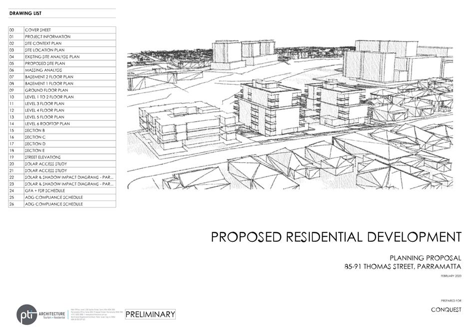
SUBJECT Planning Proposal for 85-91 Thomas Street, Parramatta
REFERENCE RZ/11/2016 - D07090076
REPORT OF Project Officer Land Use
|
LANDOWNER Century 888 Pty Ltd
Applicant Think Planners
Development applications considered by Sydney central city planning panel Nil
PURPOSE:
To seek Local Planning Panel (LPP) advice on a Planning Proposal for land at 85-91 Thomas Street, Parramatta for the purposes of seeking a Gateway Determination from the Department of Planning, Industry and Environment in accordance with the Council Officer’s recommendation.
|
|
That the Local Planning Panel consider the following Council officer recommendation in its advice to Council:
(a) That Council endorse the Planning Proposal at Attachment 1 for the purpose of seeking a Gateway Determination for land at 85 – 91 Thomas Street, Parramatta which seeks to amend Parramatta Local Environmental Plan 2011 (PLEP 2011) by: i. Maintaining the R4 – High Density Residential zone for the developable part of the site (3,825sqm) and extending the RE1 – Public Recreation zone for the undevelopable land affected by the Natural Resources - Biodiversity control, ii. Increasing the maximum Building Height (HOB) control from 11 metres to 22 metres across the R4 zoned part of the site, and removing the HOB control from the undevelopable land, iii. Increasing the Floor Space Ratio (FSR) control from 0.8:1 to 1.3:1 across the R4 zoned part of the site, and removing the FSR control from the undevelopable land, iv. Removing No.85 Thomas Street from the Land Reserved for Acquisition Map, subject to agreement being reached regarding the Planning Agreement referred to in (d) below.
(b) That Council forward the Planning Proposal to the Department of Planning, Industry & Environment (DPIE) with a request for a Gateway Determination.
(c) That a site-specific Development Control Plan (DCP) be prepared and reported to Council prior to exhibition.
(d) That a draft Planning Agreement, based on the submitted Letter of Offer from the landowner and analysis in this report, be prepared and reported to Council prior to exhibition.
(e) That the Planning Proposal, draft site-specific DCP and draft Planning Agreement be exhibited concurrently in accordance with the conditions of the Gateway Determination.
(f) That Council makes a request to DPIE that the CEO will be exercising the plan-making delegations for this Planning Proposal as authorised by Council.
(g) Further, that Council authorise the CEO to correct any minor anomalies of a non-policy and administrative nature that may arise during the plan-making process. |
SITE CONTEXT AND CURRENT PLANNING CONTROLS
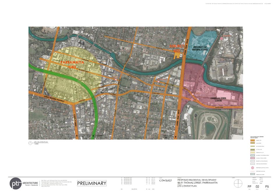
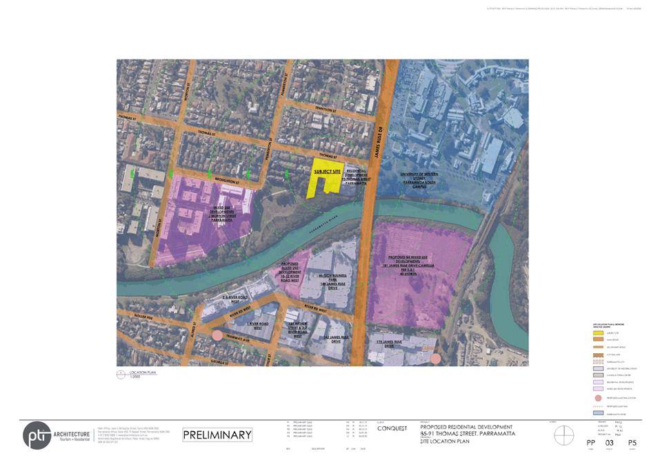
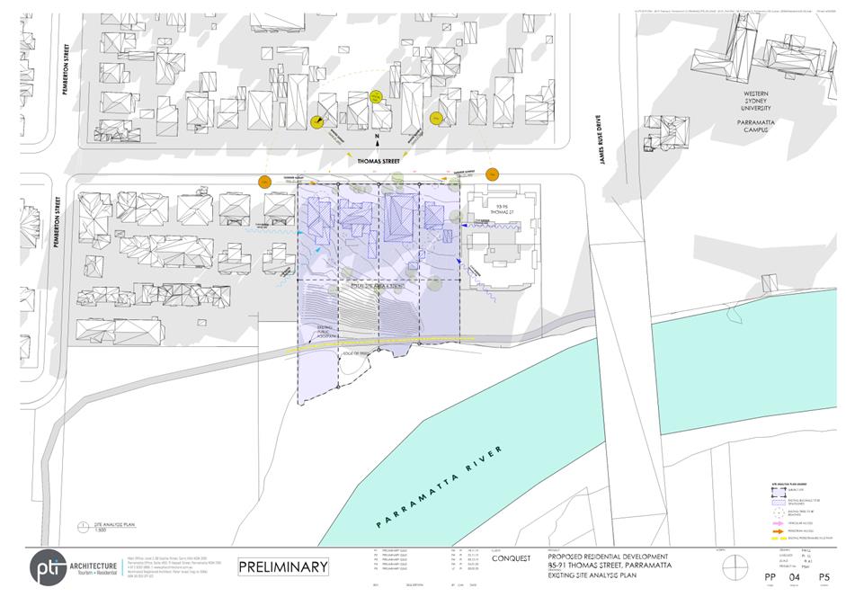
1. The site at 85-91 Thomas Street, Parramatta is subject to Parramatta Local Environmental Plan (PLEP) 2011. It includes four (4) properties on the southern side of Thomas Street (see Figure 1) with a total site area of 6,321sqm. The 4 lots that form the subject site each contain a single dwelling house, all of which are owned by Century 888 Pty Ltd (the landowner). The legal descriptions of the properties are listed below:
i. Lot 13 DP 1239 known as No. 85 Thomas Street
ii. Lot 142 DP 537053 known as No. 87 Thomas Street
iii. Lot 15 DP 1239 known as No. 89 Thomas Street
iv. Lot 16 DP 1239 known as No. 91 Thomas Street

Figure 1 - Subject site at 85-91 Thomas Street, Parramatta
2. The southern part of the total site slopes steeply and comprises mature vegetation adjacent to the Parramatta River and the Parramatta Valley Cycleway (see Figure 1). This part of the site is largely undevelopable, with future development located within the developable area at the northern part of the site (see Figure 2).
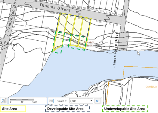
Figure 2 – Topography of subject site
3. The majority of the subject site (approx. 5,025sqm) is currently zoned R4 – High Density Residential, with the southern portion (approx. 1,296sqm) of the property at 85 Thomas Street zoned RE1-Public Recreation (see Figure 3). The site is situated within an existing high-density residential zoned precinct between Parramatta River, Macarthur Street, Victoria Road and James Ruse Drive. The precinct has a mix of low-rise residential flat buildings and detached single dwelling houses.
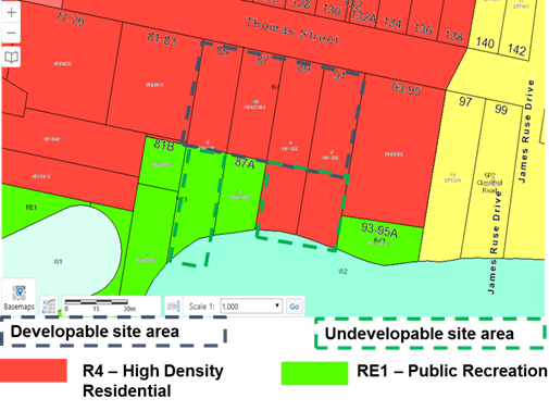
Figure 3 – Zoning of the subject site
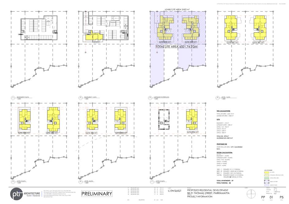
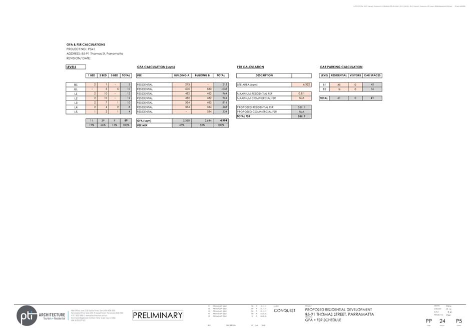
4. The PLEP 2011 currently applies a Floor Space Ratio (FSR) control of maximum 0.8:1 to the R4 zoned part of the site. This could generate a maximum of 4,020sqm of GFA across the site shown in Figure 4.
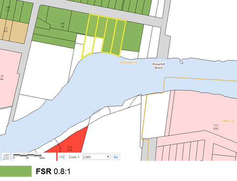
Figure 4 – Current Floor Space Ratio control
5. The PLEP 2011 currently applies a maximum Building Height (HOB) control of 11 metres to the R4 zoned part of the site shown in Figure 5.
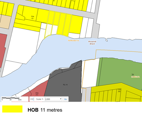
Figure 5 – Current Maximum Building Height control
6. The site is part affected by Heritage (see Figure 6), with some of the undevelopable land affected by Schedule 4, Item 1, Parramatta River (Wetlands), identified as holding Local Heritage Significance. The Planning Proposal and reference design do not propose future development within this part of the site.
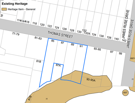
Figure 6: Current Heritage control on subject site
7. Other LEP controls impacting the subject site include Acid Sulfate Soils, Natural Resources – Biodiversity, Natural Resources – Riparian Land and Waterways, Foreshore Building Line, and Land Reserved for Acquisition. No change is being sought to these controls as part of this Planning Proposal.
BACKGROUND ON PLANNING PROPOSAL
8. On 6 June 2016, Think Planners (the Applicant) lodged a Planning Proposal with the City of Parramatta Council on behalf of the landowners, Century 888 Pty Ltd to amend the planning controls applicable to 85-91 Thomas Street, Parramatta (subject site). This initial Planning Proposal sought the following changes to Parramatta LEP 2011:
· Amend the Floor Space Ratio (FSR) control from 0.8:1 to 2.2:1
· Amend the Height of Building (HOB) control from 11 metres (3 storeys) to 34 metres (11 storeys).
9. The proposal was referred internally seeking comments from relevant Council sections. Numerous concerns were raised in relation to the scale and density of the proposal within the context of the surrounding area, impacts of the development on the ecologically significant saltmarsh and mangroves to the south, and the potential cumulative traffic and transport impacts that would result due to the precedent of allowing the Planning Proposal to proceed in its initial form.
10. When the initial Planning Proposal was lodged in June 2016, the subject site was able to achieve approximately 5,057sqm of GFA under the planning controls. However, a Council led LEP Amendment known as Parramatta LEP 2011 – Amendment No.20 - Review of Land Reserved for Acquisition, reduced the development potential of the subject site to a maximum GFA of 4,020sqm.
11. When Parramatta LEP 2011 – Amendment No.20 was gazetted on 28 July 2017, the amendment rezoned approximately 1,296sqm of land at the southern portion No.85 Thomas Street from R4 – High Density Residential to RE1 – Public Recreation with land acquisition proposed for local open space. This subsequently places an acquisition burden on Council (see Figure 7).
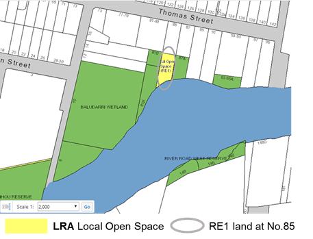
Figure 7 – Land Reserved for Acquisition subsequent to PLEP 2011 Amendment No.20
12. This LEP amendment also applied riparian and biodiversity provisions under Parramatta LEP 2011 (see Figure 8) to the ecologically significant land, of approximately 1,200sqm of R4 – High Density Residential zoned land at the southern portion of No.89 and 91 Thomas Street. While this land remains zoned R4, maximum building height and floor space ratios still apply to this land.
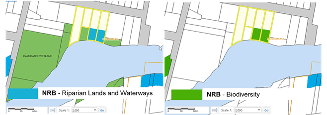
Figure 8 – Natural Resources controls applying to site since PLEP 2011 – Amendment No.20
13. The net effect of this amendment reduced the R4 – High Density Residential zoned land on the site from 6,321sqm to 5,025sqm, and reduced the developable area of the remaining R4 zoned land from 6,321sqm to 3,825sqm.
CURRENT PLANNING PROPOSAL
14. On 4 February 2020, the applicant submitted a revised Planning Proposal for 85-91 Thomas Street, Parramatta. This version of the Planning Proposal seeks to amend the planning controls for the site as follows:
· Maintain the existing Part R4 High Density Residential and Part RE1 – Public Recreation zoning for the site,
· Increase the maximum Building Height (HOB) from 11 metres to 25 metres
· Apply a Floor Space Ratio (FSR) of 0.8:1 across the entire site area
· Dedicate the undevelopable portion of the land identified for Natural Resources and Local Open Space to Council but allow high-density residential GFA be obtained from this area.
15. The Planning Proposal and changes to planning provisions for 85-91 Thomas Street, Parramatta are summarised in Table 1. This includes some recommended changes to the submitted Planning Proposal outlined in more detail below under the assessment of the Planning Proposal.
Table 1: Summary of Planning Proposal for 85-91 Thomas Street, Parramatta
|
Parramatta LEP 2011 |
Planning Controls before 28 July 2017 |
Current Controls |
Applicant’s Planning Proposal |
Council Officer’s Recommended Planning Proposal |
|
Zoning |
R4 – High Density Residential (6,321sqm) |
Part R4 High Density Residential (5,025sqm), Part RE1 Public Recreation (1,296sqm) |
As current controls |
Part R4 High Density (Developable Portion approx. 3,825sqm), Part RE1 Public Recreation (Undevelopable portion approx. 2,496sqm) |
|
Maximum HOB
|
11 metres (3 storeys) |
11 metres (3 storeys) (R4 land only) |
25 metres (R4 land only) |
22 metres (6 storeys) (R4 land only) |
|
Maximum FSR
|
0.8:1 (entire site area) |
0.8:1 (R4 land only) |
0.8:1 (entire site area) |
1.3:1 on R4 land (with land dedication) |
|
Maximum GFA |
5,057sqm (based on the total site area) |
4,020sqm (based on R4 High Density Residential only) |
4,994sqm (based on the submitted concept design) |
Approx. 4,973sqm (based on developable site area) |
|
FSR on Developable Portion 3,825sqm |
1.32:1 |
1.05:1 |
1.3:1 |
1.3:1 |
|
Other Planning Controls |
Foreshore Building Line, Acid Sulfate Soils, Heritage |
Foreshore Building Line, Acid Sulfate Soils, Heritage, Land Reserved for Acquisition, Natural Resources – Biodiversity, Natural Resources – Riparian Lands and Waterways |
As current controls |
As current controls |
|
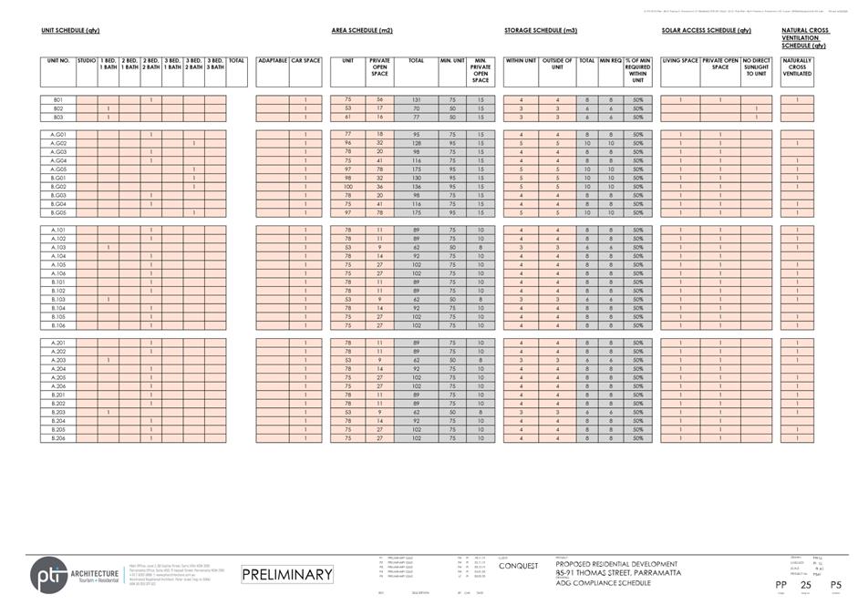
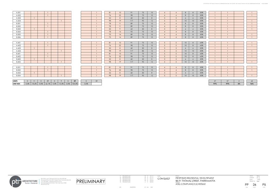
Approximate Dwelling yield (based on 85sqm per dwelling) |
59 dwellings |
47 dwellings |
59 dwellings |
59 dwellings
|
ASSESSMENT OF PLANNING PROPOSAL
16. In summary the recommended Planning Proposal is as follows:
· Maintain the R4 – High Density Residential for the developable part of the site (3,825sqm) and extend the RE1 – Public Recreation zoning at No.85 Thomas Street, to the undevelopable land affected by the Natural Resources – Biodiversity Control at No.89 and No.91 Thomas Street,
· Increase the maximum Height of Building (HOB) control from 11 metres to 22 metres (6 storeys) across the R4 zoned part of the site, removing the HOB control from the undevelopable land (the submitted Planning Proposal sought a maximum height of 25 metres (7 storeys)),
· Increase the Floor Space Ratio (FSR) control from 0.8:1 to 1.3:1 across the R4 zoned part of the site, removing the FSR control from the undevelopable land,
· Dedicate the existing RE1 land and adjacent Natural Resources affected area to Council.
State Planning Policies
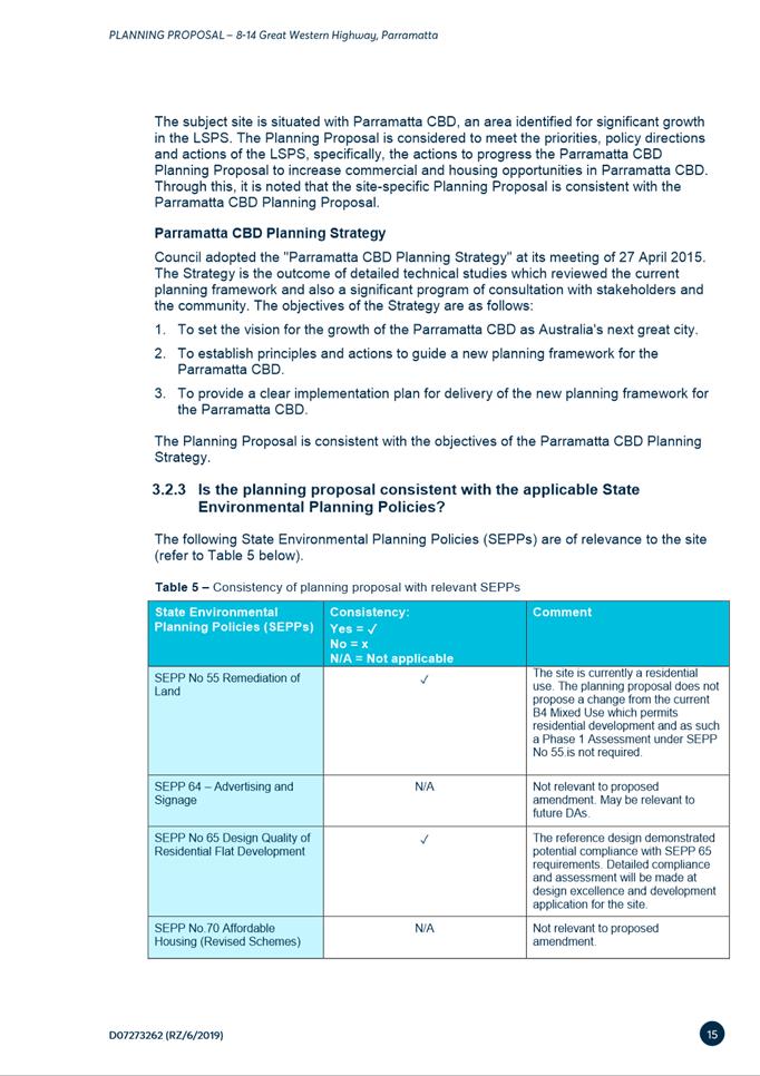
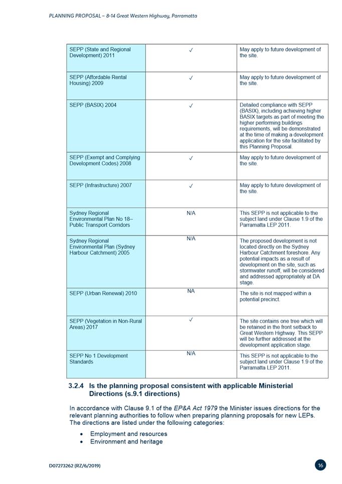
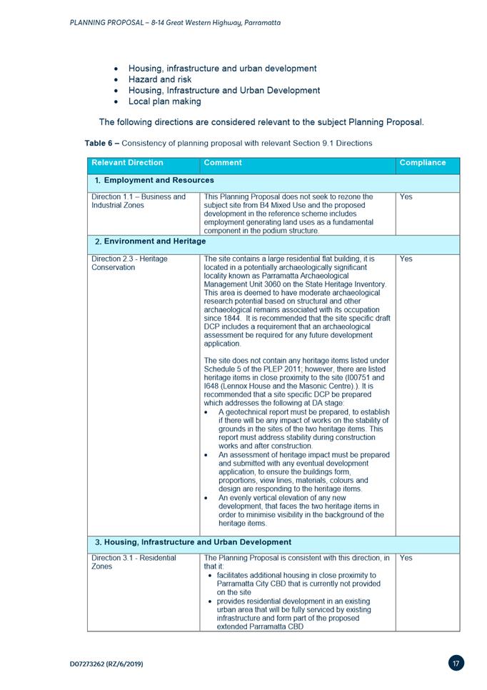
17. The Planning Proposal is generally consistent with the relevant state policies and planning strategies including the Central City District Plan, State Environmental Planning Policies (SEPPs) and Ministerial Directions under Clause 9.1 of the Environmental Planning and Assessment Act 1979. A full assessment of the proposal alignment with key state policies and planning strategies is included in Attachment 1.
District Plan
18. The Central City District Plan (CCDP), covers the area that includes Blacktown, Cumberland, Parramatta and The Hills LGAs. The role of this Plan is to help deliver the ten directions of the overarching Greater Sydney Region Plan A Metropolis of Three Cities and contains a number of planning priorities and objectives that address infrastructure provision and collaboration, liveability, productivity and sustainability objectives. Whilst the CCDP makes many references to future development in Parramatta, this principally relates to the Parramatta CBD where this site is not located. The CCDP, at this high level, does not anticipate the land along Thomas Street as an area for future growth. A full assessment of the application in relation to the Greater Sydney Region Plan and Central City District Plan is provided in the Planning Proposal document at Attachment 1.
Greater Parramatta Olympic Peninsula
19. The Greater Parramatta and Olympic Peninsula (GPOP) corridor is a high growth corridor that anticipated to grow significantly by 2036 due to its location in the geographic centre of Greater Sydney, accessibility to the metropolitan centres, and city-shaping transport corridors, including Parramatta Light Rail and Sydney Metro West. The site is within the “Shorts Corner” precinct on the periphery of Quadrant 1 and Quadrant 2 of the GPOP area (see Figure 9).
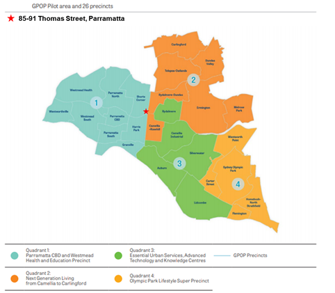
Figure 9 – Subject site within GPOP (Source: GSC)
20. On 7 November 2019, the GSC released the draft Place-based Infrastructure Compact (PIC) for the Greater Parramatta and Olympic Peninsula (GPOP) area. Specifically, the PIC outlines a draft-sequencing plan to support GPOP and growth in certain precincts in order to inform capital investment plans and budget processes of NSW Government agencies. The site is situated within the “Shorts Corner” precinct, which is not identified as an area for prioritised growth in the short to medium term. Notwithstanding, the Planning Proposal does not propose a significant increase in GFA compared to what was achievable on the site prior to the recent rezoning under Parramatta LEP 2011 – Amendment 20 that introduced RE1 zoning, land acquisition and riparian and biodiversity controls on the site and therefore would not place a significant need on infrastructure demand. It is considered by Council officers that the Planning Proposal can proceed despite the recommendation of the draft PIC.
Local Strategies
21. Councils are required to prepare a Local Strategic Planning Statement (LSPS) by the State Government. The LSPS sets out the long-term vision for land use planning in a council’s local government area (LGA) and responds to broader priorities identified in the District Plans and integrates with a Council’s Community Strategic Plan. The LSPS provides greater weight to strategic planning in the broader plan making process and any new planning proposal must justify any inconsistency with this framework and the supporting Local Housing Strategy (LHS) and Employment Lands Strategy (ELS).
22. Council’s Local Strategic Planning Statement was published on 31 March 2020. The LSPS provides strategic direction on how the City of Parramatta is planning for the next 20 years. The site is not in an area identified for significant growth in the LSPS. However, given the site is already zoned R4 – High Density Residential and that the Planning Proposal is not seeking a significant uplift over and above what the site could previously achieve, the Planning Proposal is considered to be consistent with the LSPS in this instance.
Precedent for surrounding R4 sites
23. The initial Planning Proposal proposed a significant increase in density up to an FSR of 2.2:1 and commensurate increase in maximum building height to 34 metres, which could have accommodated approximately 150 apartment dwellings within a 10-storey building. That initial Planning Proposal scheme could be considered a precedent for the surrounding R4 zoned sites between Parramatta River, Macarthur Street, Victoria Road and James Ruse Drive to change to a similar built form. It also raised the need to investigate the cumulative impacts of traffic, urban design, parking and the coastal saltmarsh in the surrounding area if the Planning Proposal proceeded in that form. A map showing the broader existing zoning context is shown in Figure 10 below.
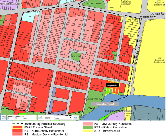
Figure 10 - Subject site and subdivision pattern and zoning of surrounding precinct
24. The applicant has subsequently revised their proposal in response to feedback from Council officers and have provided a scheme that is considered to not set a precedent for the broader area given the reduced density and height.
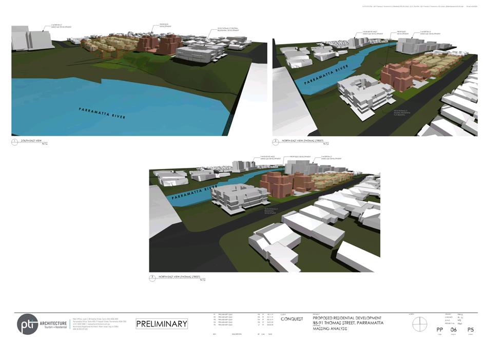
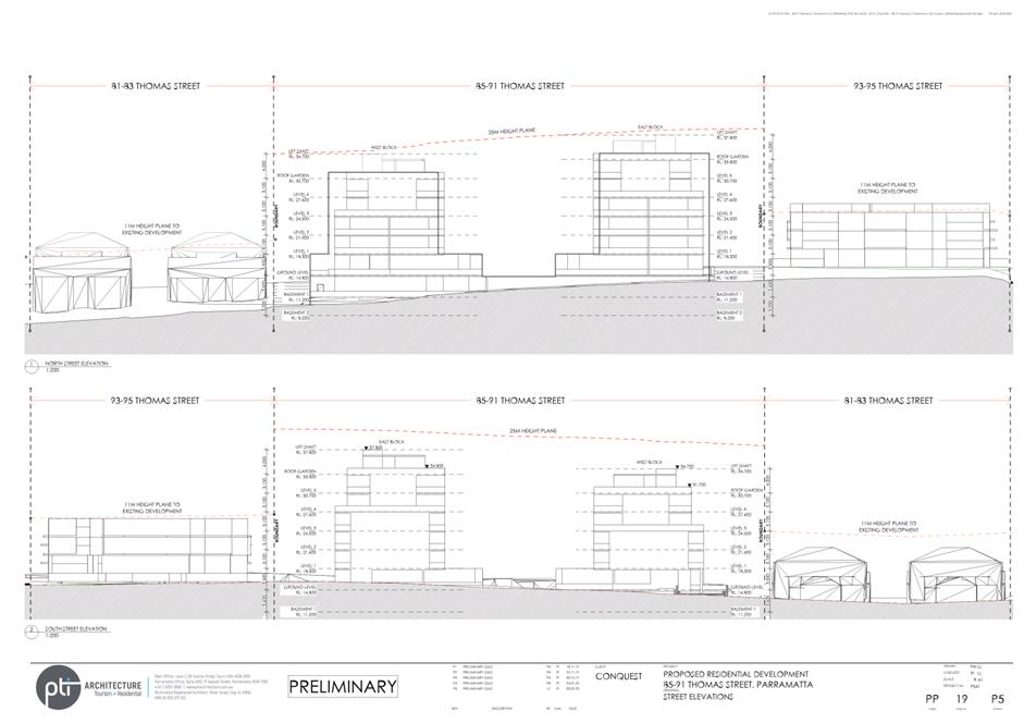
25. The adjacent properties have already been redeveloped for high-density residential purposes including townhouses/villa development at 81-83 Thomas Street (0.8:1 density and 11m height) and a residential flat building at 93-95 Thomas Street (0.8:1 density and 11m height) as shown in Figure 11. These adjacent sites are not affected by land acquisition and natural resources planning controls and are able to mass their GFA proportionately across their site area within their height limit.
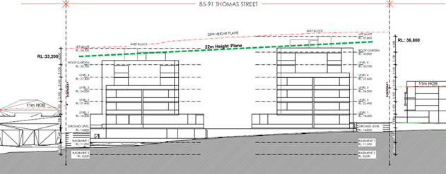
Figure 11 – Section facing north from Parramatta River with adjacent properties (Source: PTI Architecture)
26. The current concept design redistributes GFA from the undevelopable 2,496sqm of the site in the south into a built form at the northern developable part of the site (approximately 3,825sqm) in an envelope sympathetic to the adjacent land uses, streetscape and nearby ecological areas. There is no net increase in GFA from what could be achieved prior to part of the site being rezoned to RE1 Public Recreation with land acquisition and natural resources planning controls, and other nearby R4 zoned sites do not include significant undevelopable areas. Given this, it is considered that the potential for the current Planning Proposal to set a precedent for further Planning Proposal applications in the surrounding area is minimal.
Urban Design
27. In order to support the changes to the planning provisions included in the planning proposal, the applicant has submitted a reference design to demonstrate that the revised planning controls will be able to support a development that is suitable for the site and its surrounding context. A copy of the reference design is included at Attachment 2. The following section provides an analysis of the reference design that will form the basis of a site specific DCP that will support the Planning Proposal should it proceed.
Streetscape
28. Future development on the site must have regard for its streetscape setting and address the scale of adjacent development and rhythm of the surrounding subdivision pattern. Figure 12 illustrates the massing of building envelopes along Thomas Street, including the proposed building envelope for 85-91 Thomas Street shown in red.
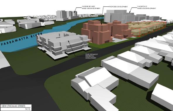
Figure 12 – Massing of building envelopes along Thomas Street, with subject site shown in red (Source: PTI Architecture)
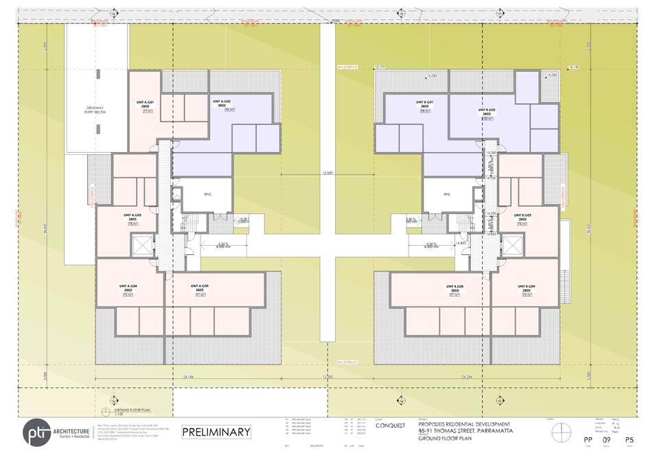
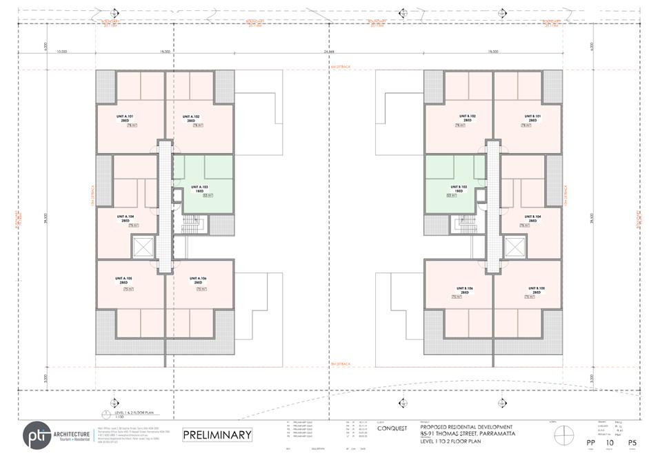
29. The proposed building envelope includes two apartment blocks spaced evenly across the 4 lots that make up the site, with additional front and side setbacks for Levels 5 and 6 which provide a transitioning scale and separation to the scale of development nearby. Figure 13 shows how the proposed building envelope appears next to the adjacent residential sites when viewed from Thomas Street.
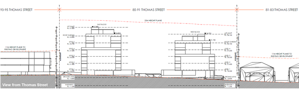
Figure 13 – Scale of building envelopes along Thomas St with adjacent development
30. While the Planning Proposal represents a change in scale for built form on the site, the existing zoning does permit a residential flat building development, and the building layout in the reference design represents a reasonable development outcome when viewed from the street. The modulation of the façade will also be supported by landscaping and further design detail at Development Application stage as guided by the site specific DCP. Further details on adequate building separation and setbacks are detailed later in this section.
Floor Space Ratio
31. As noted in Table 1, the applicant’s submitted scheme generates 4,994sqm of GFA for high-density residential purposes. This amount is 953sqm greater than the current planning controls allow, resulting in approximately 12 additional apartment dwellings. It is also 63sqm less than the GFA permissible on the site at lodgement in June 2016 when a 0.8:1 FSR control applied to the entire site area (i.e. 5,057sqm of GFA).
32. However, the recommended changes to the FSR control seek to redistribute the FSR that could be achieved across the whole site and apply it only to the developable portion of the site. Therefore, in order to maintain the same approximate yield, this results in the FSR increasing from 0.8:1 across the whole site to 1.3:1 for the developable portion of the site. This approach is recommended given the potential dedication of the non-developable portion of the site to Council that is dealt with in more detail under the Planning Agreement Offer section of this report.
33. The Planning Proposal aims to amend the maximum Building Height and Floor Space Ratio controls to accommodate no net increase in high density residential GFA compared to what was previously permissible under planning controls for the site at lodgement of the application. Therefore the dwelling yield, while increasing compared to the current controls, will be the same when compared to the planning controls which applied to the site when the Planning Proposal was lodged with Council.
Building Height
34. The existing building height control allows for high-density residential development of a maximum of 3-storeys to be accommodated on the site. The adjoining property at 93-95 Thomas Street demonstrates a recent example of what could be developed under the existing planning controls (DA/630/2012). This neighbouring development is able to comfortably achieve the current maximum FSR within the existing building height as it does not need to respond to the topographic constraints and foreshore building line evident on the subject site, which significantly reduces the developable area of the subject site.
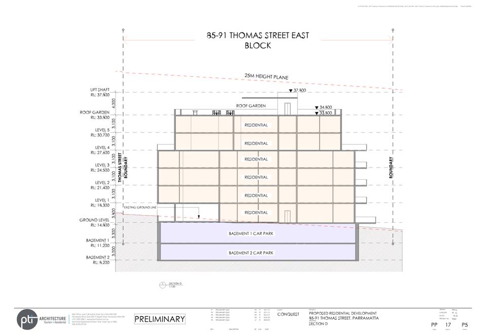
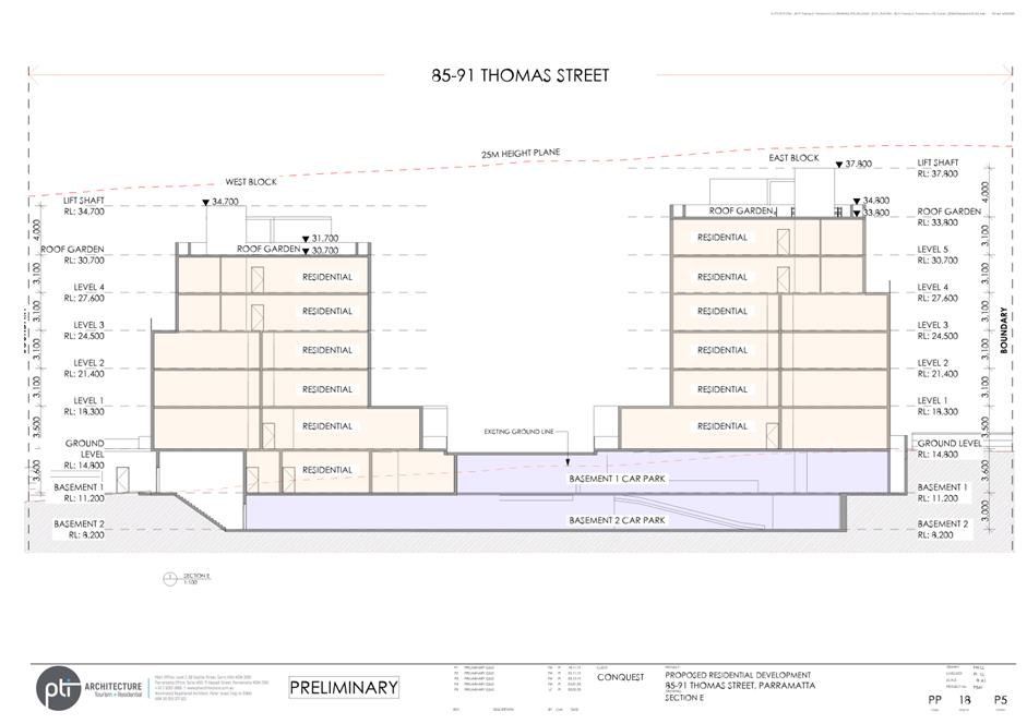
35. The applicant’s Planning Proposal proposes a 25 metres Maximum Building Height which could accommodate approximately 7 storeys. This height limit is considered excessive given the reference design proposes only 6 storeys development on the site. Figure 14 shows that a 22m height plan can accommodate the reference design and reasonably achieve a 6 storeys development despite the sloping topography.
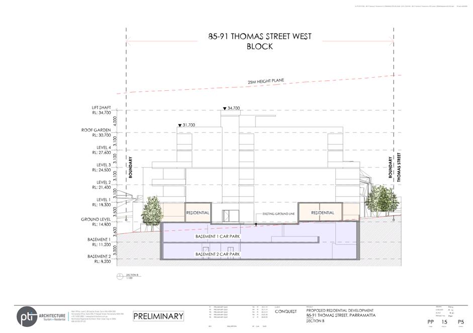
36. The 6 storey height is supportable with a 4 storey street wall, additional setbacks for the 5th & 6th storeys and separation from adjacent development. The reference design accommodates a 3.3m variation between the proposed ground level at Thomas Street (RL 14.5m) and lower ground level at the rear (RL 11.2m). This maintains a 4 storeys form at street level and no more than 6 storeys across the site.
![]()

Figure 14 – Section facing east (Source: PTI Architecture) UPDATED FIGURE SHOWING 4+2
Building Separation and Setbacks
37. Given the potential increase in building height on the subject site, it is important to carefully manage privacy and amenity impacts on the adjacent properties, particularly the adjacent townhouse development located near the boundary at 81-83 Thomas Street and single dwelling houses on the northern side of Thomas Street.
38. The Apartment Design Guide and SEPP 65 set the minimum standards for building separation and setbacks for any residential flat building development on the site. Currently, the ADG would require a minimum of 9 metres separation between habitable and non-habitable rooms for buildings up to 4 storeys, and minimum of 12 metres for buildings 5 to 8 storeys.
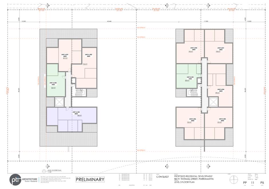
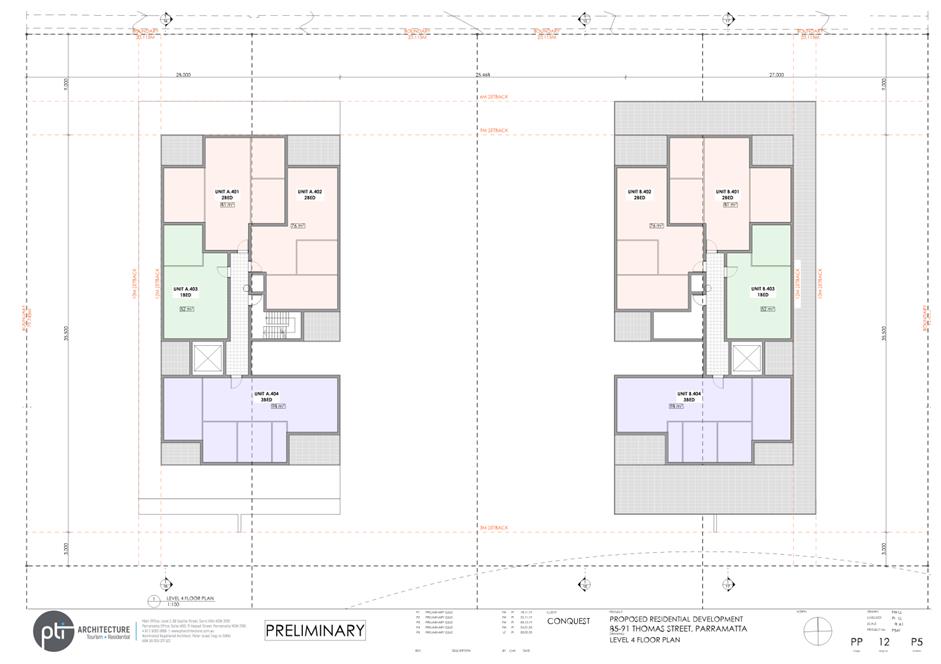
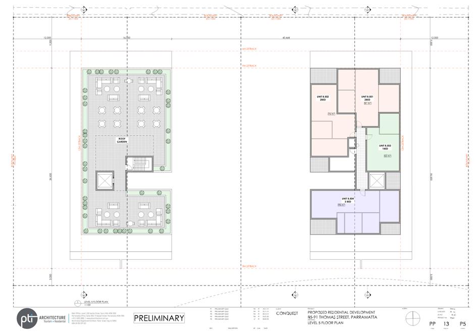
39. Building setbacks proposed as part of the reference design are shown below in Figures 15 and 16. These are labelled alphabetically and measure as follows:
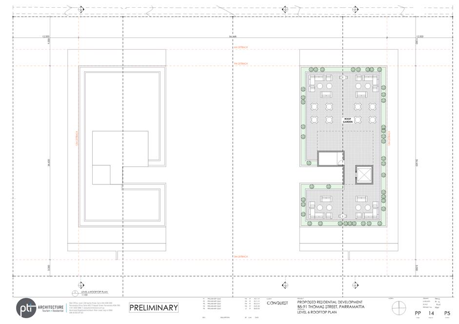
a. Street setback of 6 metres up to 4 storeys, 9 metre setback up to 6 storeys, 10 metres for rooftop,
b. Side setback of 10 metres up to 4 storeys, 12 metre setback up to 6 storeys, 13 metre for rooftop,
c. Minimum 12 metres building separation between west and east block apartment buildings within the site,
d. Rear setback of 3 metres to edge of developable portion of site and foreshore building line,
(refer to Figure 15 for up to 4 storeys, Figure 16 for up to 6 storeys, and in detail at Attachment 2).
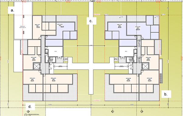
Figure 15 –Setbacks up to 4-storeys for developable site area, see p.12 Attachment 2 (Source: PTI Architecture)
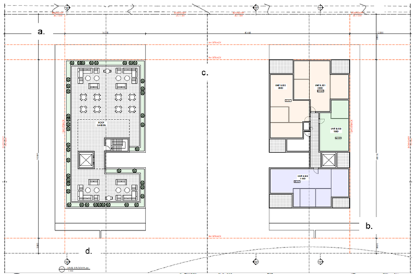
Figure 16–Setbacks for Level 5 and 6 for developable site area, see p.14 Attachment 2 (Source: PTI Architecture)
40. Deep soil areas and tree plantings within 6 metres of the front and side property boundary will also be required to further improve the relationship of the site with neighbouring buildings. This aims to provide a satisfactory interface with adjacent properties and address concerns relating to privacy and amenity.
41. The setbacks proposed under the reference design are considered sufficient in addressing the privacy and amenity of neighbouring and future residents. These setback standards will be reinforced through the proposed site-specific DCP that will accompany this Planning Proposal.
Traffic & Parking
42. The current application proposes an increase in density compared to the current controls, but in keeping with the density achievable under the planning controls which were in place when the Planning Proposal was lodged. Council’s Traffic section advised that this arrangement does not require a precinct wide traffic and parking analysis to be completed given the circumstances.
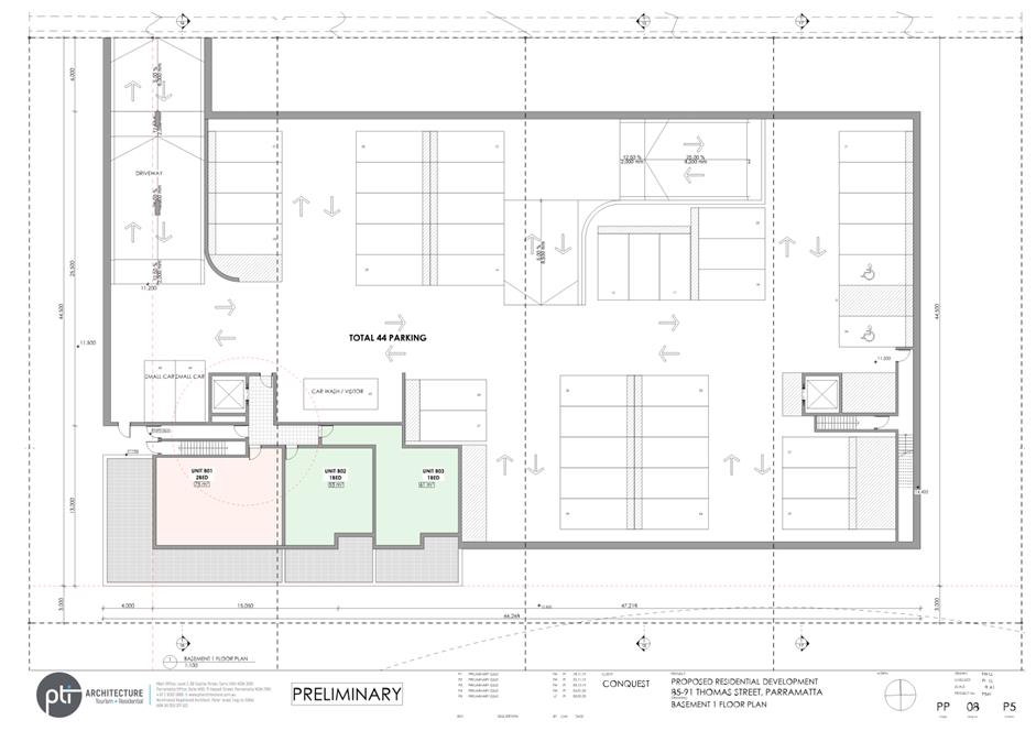
43. Car-parking on the site is proposed in a 2 storeys basement within the building envelope, away from deep soil zones, with driveway access located at the lower ground level in the western portion of the site further away from the Thomas Street/James Ruse Drive intersection to the east. The provision of 61 car-parking spaces is consistent with Council’s Traffic Engineer advice that this is an acceptable amount of car-parking as well as locating the driveway entrance within the building envelope and access ramp design in accordance with AS 2890.1:2004. The traffic and parking matters are satisfactory for the purpose of requesting a Gateway Determination.
Heritage
44. The Planning Proposal was referred to Council’s heritage advisor because part of the site is affected by Heritage Item 1, Parramatta River Wetlands which is identified as having local significance under Parramatta LEP 2011.
45. Council’s Heritage Advisor responded in July 2016, outlining that the “wetlands along Parramatta River are of significance for Parramatta area as a remnant representative area of mangroves and salt marshes which once extensively lined the foreshores and tidal water flats of the region” and “thus any proposed development on, or in close proximity of, the area of Wetlands will have to be carefully scrutinised”.
46. The current Planning Proposal seeks to locate the building envelope outside the area affected by the heritage listing thereby addressing the heritage and ecological concerns. The Planning Proposal will be referred to the Department of Environment, Energy and Science regarding the potential impacts on the adjoining wetland as part of a public exhibition associated with a Gateway Determination should the Planning Proposal proceed.
Ecology
47. The site is affected by the Foreshore Building Line under Parramatta LEP 2011, subject to the Coastal Management SEPP 2018 as it adjoins “Coastal Wetlands” and is located within a 100m buffer zone of the Mean High Water Mark of the Parramatta River. These matters are addressed in detail as part of the Planning Proposal in Attachment 1.
48. The Planning Proposal was referred to the Department of Primary Industries in 2017 seeking comment regarding potential shading impacts to marine vegetation being the mangroves and saltmarsh to the south of the site. On 15 May 2017, Primary Industries recommended a precautionary approach regarding the ongoing long-term impacts to both the mangroves and saltmarsh. The applicant then submitted revised information that allowed Primary Industries to complete a further assessment. Primary Industries clarified on 9 November 2017 that it “does not see any reason for potential shading issues on mangrove and saltmarsh species to prevent the lodgement of this development, as currently proposed, as a planning proposal”. A copy of the advice from Primary Industries is included at Attachment 4.
49. The Planning Proposal has been amended to a scale below the 10 storeys development reviewed and considered acceptable by the Department of Primary Industries, therefore the current scheme should satisfy and be consistent with their 2017 advice. The Planning Proposal will be referred again to Department of Primary Industries regarding the ecological matters as part of a public exhibition associated with a Gateway Determination should the Planning Proposal proceed.
DEVELOPMENT CONTROL PLAN
50. Given the characteristics of the site and the nature of redevelopment proposed, a site-specific DCP will be required to support any future development on the site. The site-specific DCP would guide the redevelopment of the site, having regard to the local context and detailed design requirement for the site, including, but limited to the following:
· Built Form and Massing
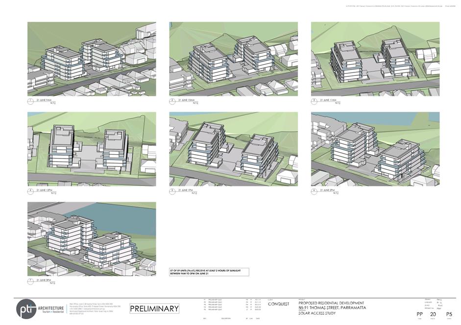
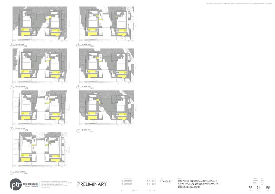
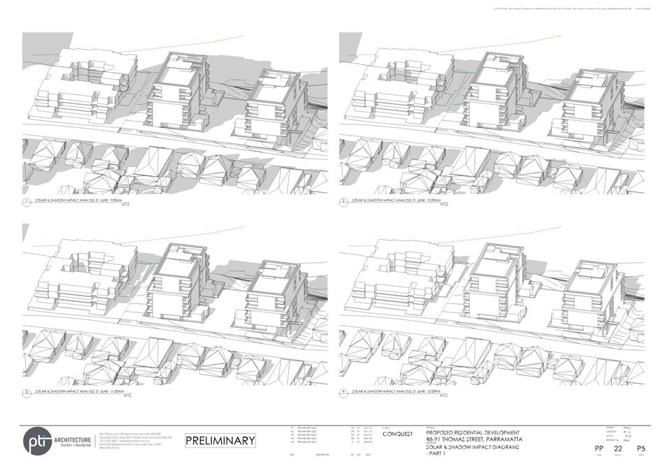
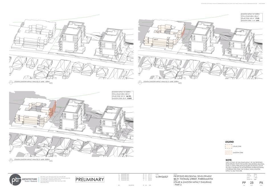
· Solar Access and Overshadowing
· Traffic, Transport and Parking
· Landscaping and Open Space
51. The site-specific DCP can be prepared once the Planning Proposal has been submitted for Gateway Determination and the extent of the development on the site is established. Should the Planning Proposal proceed in its current form, the site-specific DCP will be drafted to reflect the reference design submitted in the application as contained in Attachment 2. The draft document will be reported separately to Council and will be exhibited concurrently with the Planning Proposal should it proceed to public exhibition.
PLANNING AGREEMENT OFFER
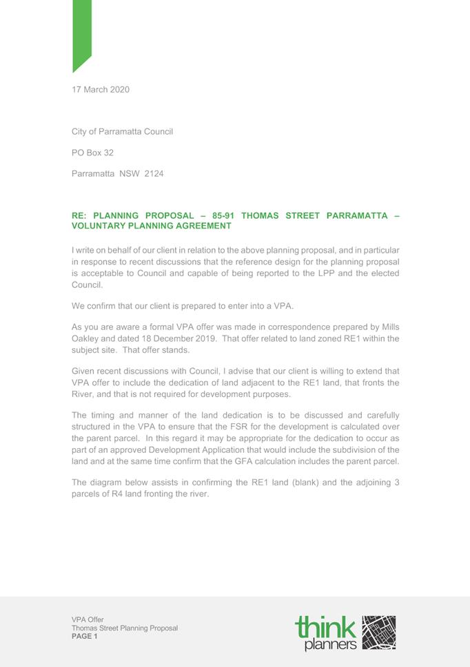
52. In order to support the Planning Proposal, the applicant indicated they intend to enter into a Planning Agreement with Council and have submitted a Letter of Offer substantiating the proposed terms of the agreement. The Letter of Offer dated 17 March 2020 proposes to dedicate to Council the part of the site that is not able to be developed for high density residential purposes. This includes the existing RE1 Public Recreation zoned land (1,296sqm) affected by a land acquisition for local open space at No.85 Thomas Street, and the undevelopable portion of R4 High Density Residential land affected by the Natural Resources control (1,200sqm) at No.89 and No.91 Thomas Street (see Figures 7 and 8). A copy of the applicant’s Letter of Offer is included in Attachment 3.
53. The Planning Agreement offer was referred to Council’s Open Space and Natural Resources Section, who indicated support for the dedication of the land given its prominent position along the Parramatta River, which includes the Parramatta Valley Cycleway currently accessed via an existing easement. It was noted that public ownership of this land will ensure the cycleway and Natural Resources affected land remains vegetated and accessible.
54. The Letter of Offer notes that the land dedication is provided on the basis that there is no decrease in GFA permissible when compared to the planning controls at lodgement and prior to PLEP 2011 – Amendment No.20 (i.e. the introduction of the RE1 Public Recreation zoning and acquisition reservation on No.85 Thomas Street, and Natural Resources controls on No.89 and No.91 Thomas Street).
55. The proposed land dedication was referred to Council’s Assets and Operations Section who support the dedication of land as part of the Planning Agreement given the existing acquisition burden for 1,296sqm of land at No.85 Thomas Street. The Assets and Operation Section also support the dedication of 1,200sqm Natural Resources - Biodiversity land at No.89 and No.91 Thomas Street to ensure this land is protected for natural resource purposes. The estimated cost of ongoing maintenance for the total 0.25ha land would cost approximately $5,000 per year. The maintenance cost would be added to the existing maintenance contract for the adjoining reserve.
56. The Planning Agreement proposes to dedicate land that is identified for acquisition under PLEP 2011 free of cost, thereby removing an acquisition burden on Council. Without the Planning Proposal and associated Planning Agreement, Council would ultimately be required to purchase the land from the owner at a market rate.
57. If the 1,296sqm of privately owned RE1 zoned, affected by the land acquisitions at No.85 Thomas Street is not dedicated at no cost as part of Planning Agreement negotiations, Council officers estimate this land could cost approximately $1.3 million (between $1.28-1.35 million) to purchase which equates to approximately $1,003/sqm. This figure is based on general advice provided by Council’s Property Development Group who estimate a value of $992-$1,040/sqm for the land. However, a detailed valuation has not been undertaken at this stage to verify the current value of the land given the nominal uplift being sought by the Planning Proposal and that the land is being dedicated to Council free of cost.
58. The Planning Agreement also seeks to facilitate the dedication of the undevelopable portion of the R4 High Density Residential zoned land to Council free of cost. This land is intended to provide a contiguous vegetation buffer along the rear of the site with the adjacent RE1 Public Recreation land. It is recommended that this portion of the R4 High Density Residential zone be rezoned to RE1 Public Recreation to match the adjoining land and to properly reflect its intended use.
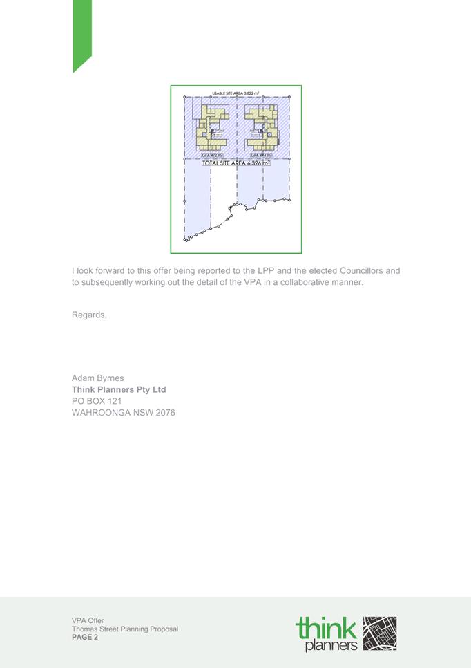
59. If the remaining 1,200sqm of privately owned, R4 zoned land affected by the Natural Resources – Biodiversity control, at No. 89 and 91 Thomas Street is not dedicated to Council, the proposed FSR would need to be redistributed across the revised site area to reflect no net increase in density compared to what could be achieved on the site prior to Amendment No. 20. However, given that the current proposal seeks to extract the FSR from this portion of the site and redistribute it on the developable site area, it is estimated that this land holds nominal to no monetary value as a result. A map showing the land proposed to be dedicated to Council as part of the Planning Agreement is shown in Figure 17 below.
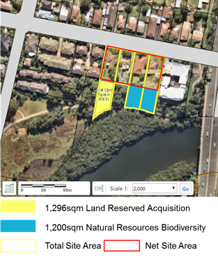
Figure 17 – Proposed Land Dedication under the Planning Agreement Letter of Offer
60. Under Council’s Planning Agreements Policy, planning proposals outside the Parramatta CBD seeking uplift in density need to be supported by a planning agreement that is valued at 50% of the resulting land value uplift. However in this instance, it is acknowledged that the gazettal of PLEP 2011 Amendment 20 reduced the development potential on the site and the planning proposal is only seeking to recoup the density potential it may have been able to achieve under the planning controls in place prior to this amendment. The dedication offer of 2,496sqm of land at the rear of the subject site provides the opportunity for Council to attain the acquisition asset on No. 85 Thomas Street at no cost and ensures the public protection of environmentally sensitive land on No. 89 and 91 Thomas Street upon Council ownership.
61. It is also acknowledged that the site may not have been able to achieve the full density potential under the current planning controls due to the constrained nature of the southern portion of the site, however the previous controls did allow development on this part of the site prior to the gazettal of Amendment 20 which would potentially facilitate more intensive development on the developable portion of the site fronting Thomas Street.
62. Proceeding with the Planning Agreement will also allow the Land Reserved for Acquisition Map under PLEP 2011 to be amended to remove the parcel of land and allow the asset to be transferred into Council ownership without the need to purchase the land. Based on the above, it is recommended that a draft Planning Agreement, based on the submitted Letter of Offer from the landowner and analysis in this report, be prepared and reported to Council prior to exhibition.
PLAN-MAKING DELEGATIONS
63. Revised delegations were announced by the then Minister for Planning and Infrastructure in October 2012, allowing councils to make LEPs of local significance. On 26 November 2012, Council resolved to accept the delegation for plan-making functions. Council has resolved that these functions be delegated to the CEO.
64. Should Council resolve to endorse the Planning Proposal to proceed, it is recommended that Council request that it exercise its plan-making delegations. This means that once the Planning Proposal has been to Gateway, undergone public exhibition and been adopted by Council, Council officers will deal directly with the Parliamentary Counsel Office on the legal drafting and mapping of the amendment. The LEP amendment is then signed by the CEO before being notified on the NSW Legislation website.
CONSULTATION & TIMING
65. The applicant’s Planning Proposal and supporting documentation were referred internally to Council’s Urban Design, Traffic and Transport, Open Space and Natural Resource teams.
66. No public consultation has been undertaken at this stage on the Planning Proposal.
67. Should Council resolve to proceed with the Planning Proposal, it (and all related information) will be submitted to the Department of Planning, Industry and Environment for Gateway Determination. Community consultation will be undertaken as required by the Gateway Determination. The Planning Proposal will be placed on public exhibition in conjunction with the site-specific DCP and draft VPA.
FINANCIAL IMPLICATION FOR COUNCIL
68. Should Council resolve to proceed with the Planning Proposal, the costs incurred in conducting the community consultation are covered by the fees associated with the submission of the Planning Proposal request. Preliminary financial implications of the Planning Agreement Letter of Offer are provided earlier in this report under Planning Agreement Offer, and will be provided in greater detail in a separate report to Council on the matter.
CONCLUSION
69. This report recommends that the Planning Proposal for 85-91 Thomas Street, Parramatta proceed to Gateway.
70. Should the proposal proceed and a Gateway Determination be issued, the Planning Proposal will be placed on public exhibition with the site specific DCP and draft Planning Agreement (once both are reported to Council) and the outcomes of the exhibition will be reported to the Local Planning Panel if any objections are received. If no objections are received, the matter will be reported directly to Council post-exhibition.
Kieren Lawson
Project Officer Land Use
Michael Rogers
Land Use Planning Manager
David Birds
Group Manager, City Planning
Jennifer Concato
Executive Director City Strategy & Development
|
1⇩ |
Planning Proposal Document |
|
|
|
2⇩ |
Reference Design - 4 February 2020 |
|
|
|
3⇩ |
Planning Agreement Offer - 17 March 2020 |
|
|
|
4⇩ |
Ecology Saltmarsh Response - RZ/11/2016 |
|
|
|
Item 6.1 - Attachment 1 |
Planning Proposal Document |
[Subject]
85-91 Thomas Street, Parramatta
TABLE OF CONTENTS
Planning Proposal drafts
INTRODUCTION
Background and context
PART 1 – OBJECTIVES OR INTENDED OUTCOMES
PART 2 – EXPLANATION OF PROVISIONS
1.1. Other relevant matters
PART 3 – JUSTIFICATION
3.1 Section A - Need for the planning proposal
3.2. Section B – Relationship to strategic planning framework
3.3. Section C – Environmental, social and economic impact
3.4. Section D – State and Commonwealth Interests
PART 4 – MAPPING
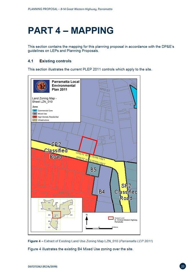
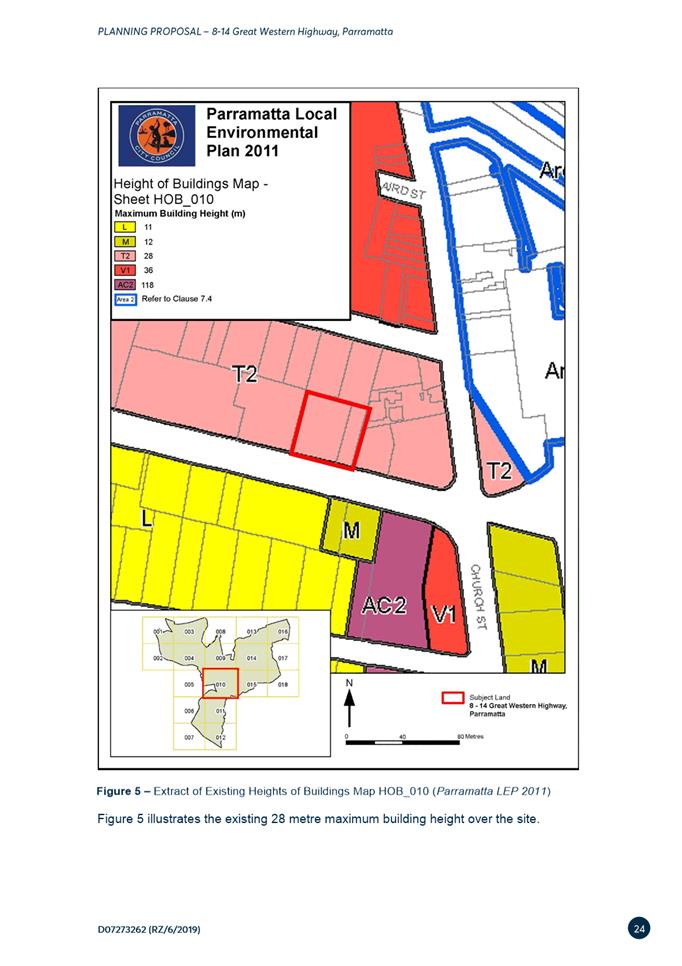
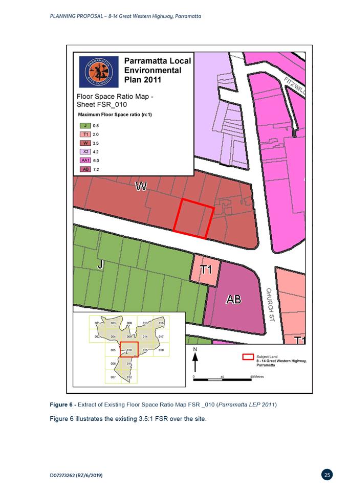
4.1 Existing controls
4.2 Proposed controls
PART 5 – COMMUNITY CONSULTATION
PART 6 – PROJECT TIMELINE
Appendix 1 – Concept Plans
Appendix 2 – Ecological Response
Appendix 3 – Traffic Report
Appendix 4 – VPA Offer
Proponent versions:
|
No. |
Author |
Version |
|
1. |
ThinkPlanners |
June 2016 – Initial Proposal |
|
2. |
ThinkPlanners |
August 2018 – Former Revision |
|
3. |
ThinkPlanners |
March 2020 – Current Scheme |
Council versions:
|
No. |
Author |
Version |
|
1. |
City of Parramatta Council |
Report to Local Planning Panel and Council on the assessment of planning proposal |
This Planning Proposal explains the intended effect of, and justification for, the proposed amendment to Parramatta Local Environmental Plan 2011. It has been prepared in accordance with Section 55 of the Environmental Planning and Assessment Act 1979 and the Department of Planning and Environment (DP&E) guides, 'A Guide to Preparing Local Environment Plans' (August 2016) and 'A Guide to Preparing Planning Proposals' (August 2016) and ‘Guidance for merged councils on planning functions’ (May 2016).
Background and context
On 6 June 2016, Council received a Planning proposal application from Think Planners which sought to amend the planning controls applicable to the site at 85-91 Thomas Street, Parramatta under Parramatta Local Environmental Plan 2011 (PLEP 2011). The land at 85-91 Thomas Street includes 4 Torrens title land parcels that are shown below and legally described as follows:
· Lot 13 DP 1239, known as No. 85 Thomas Street
· Lot 142 DP 537053 known as No. 87 Thomas Street
· Lot 15 DP 1239 known as No. 89 Thomas Street
· Lot 16 DP 1239 known as No 91 Thomas Street
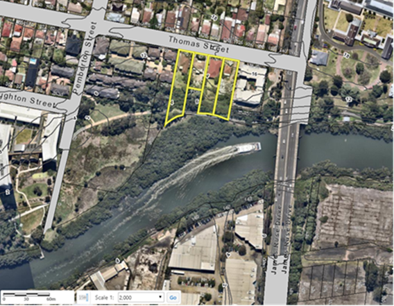
Figure 1 – Sites at 85-91 Thomas Street subject to the planning proposal
Under Parramatta Local Environmental Plan 2011 the site:
· is zoned part R4 – High Density Residential, part RE1 – Public Recreation
· has a minimum Lot Size of 550 sqm;
· has a maximum Building Height of 11 metres;
· has a maximum Floor Space Ratio (FSR) of 0.8:1;
· has a land acquisition for local open space applying to 1,296sqm of privately owned RE1 zoned land at No.85;
· 30m wide Foreshore Building Line
· Acid Sulfate Soils,
· Heritage,
· Land Reserved for Acquisition,
· Natural Resources – Biodiversity,
· Natural Resources – Riparian Lands and Waterways
An extract of each the above maps is provided in Part 4 – Mapping; specifically, Section 4.1 Existing controls.
PART 1 – OBJECTIVES OR INTENDED OUTCOMES
The objective of this Planning Proposal is to adjust the land use zoning, building height and floor space ratio on the site at 85-91 Thomas Street to accommodate a residential flat building development within the developable portion of the site. In order to accommodate the gross floor area of 0.8:1 across the privately owned site, there will be an adjustment in land use zoning boundaries, increase in maximum building height and maximum floor space ratio for the proposed R4 land.
The owners of the subject site (Century 888 Pty Ltd) authorised ThinkPlanners to submit the original Planning Proposal in June 2016 to coordinate the matters relating to the subject site and this rezoning application.
The Planning Proposal intends to deliver the following outcomes for the site:
− Accommodate high-density residential development up to 4,973sqm outside the undevelopable portions of the site
− Locate the building envelope and mass the Gross Floor Area within the developable portion of the site,
− Accommodate similar amount of GFA on the site as permitted by the planning controls prior to Parramatta LEP 2011 – Amendment No.20 Review
− Dedicate land identified for acquisition, public open space and natural resources.
PART 2 – EXPLANATION OF PROVISIONS
This planning proposal seeks to amend Parramatta LEP 2011 (PLEP 2011) in relation to the zoning and height controls.
In order to achieve the desired objectives the following amendments to the PLEP 2011 would need to be made:
1. Amend the Land Zoning Map to maintain the R4 – High Density Residential zone for the developable part of the site (3,825sqm) and extending the RE1 – Public Recreation zone for the undevelopable land affected by the Natural Resources - Biodiversity controls. (Sheet LZN_[010]).
2. Amend the maximum building height in the Height of Buildings Map (Sheet HOB_010) from 11 metres to 22 metres that equates to 6 storeys for the proposed R4 land within the developable area of the site. Removing the Height of Buildings control for the proposed RE1 land.
3. Amend the maximum floor space ratio in the Floor Space Ratio Map (Sheet FSR_010) from 0.8:1 to 1.3:1 for the proposed R4 land within the developable area of the site. Removing the Floor Space Ratio control for the proposed RE1 land.
4. Remove the acquisition affectation from No.85 Thomas should this be dedicated to Council.
1.1.1. Voluntary Planning Agreement
The subject site and proposed development uplift being sought lends itself to the provision of public benefits, consistent with Council’s Planning Agreements policy. The proponent expressed interest into entering a Voluntary Planning Agreement consistent with the policy. The applicant submitted a Letter of Offer on 8 August 2018. The applicant is currently proposing the following VPA item:
· Dedication 2,496sqm of privately owned land identified for land acquisition (open space) or natural resources (biodiversity) to Council within the undevelopable part of the site at the south.
Under Council’s Planning Agreements Policy, planning proposals outside the Parramatta CBD seeking uplift in density need to be supported by a planning agreement that is valued at 50% of the resulting land value uplift. It is acknowledged that the gazettal of Amendment 20 reduced the development potential on the site and the planning proposal is only seeking to recoup the density potential it may have been able to achieve under the planning controls in place prior to this amendment. Based on an acceptance of this approach, it is not considered necessary to seek a planning agreement achieving 50% land value uplift, as there is effectively no increase in overall development potential of the site. It is also acknowledged that the site may not have been able to achieve the full density potential under the previous planning controls due to the constrained nature of the southern portion of the site, however the previous controls did allow development on this part of the site and the gazettal of Amendment 20 removed that potential.
In addition, the Planning Agreement is proposing to dedicate land that is identified for acquisition under PLEP 2011 free of cost, thereby removing an acquisition burden on Council. Without the Planning Proposal and associated Planning Agreement, Council would ultimately be required to purchase the land from the owner. The Planning Agreement is also proposing to dedicate the undevelopable portion of the R4 High Density Residential zoned land to Council free of cost. This land is intended to provide a contiguous vegetation buffer along the rear of the site with the adjacent RE1 Public Recreation land. It is therefore recommended that this portion of the R4 High Density Residential zoned be rezoned to RE1 Public Recreation to match the adjoining land and to properly reflect its intended use.
It is recommended that Council authorise the CEO to enter into VPA Negotiations with the applicant
1.1.2. Draft Development Control Plan
Given the nature of redevelopment proposed on the site, a site-specific Development Control Plan (DCP) will be required to support any future development on the site. The site-specific DCP would guide the redevelopment of the site, having regard to the local context and detailed design requirement for the site, including, but limited to the following:
· Built Form and Massing
· Solar Access and Overshadowing
· Traffic, Transport and Parking
· Landscaping and Open Space
Both the draft Voluntary Planning Agreement and draft Development Control Plan will be exhibited concurrently as part of the public exhibition stage following Gateway Determination.
This part describes the reasons for the proposed outcomes and development standards in the planning proposal.
3.1 Section A - Need for the planning proposal
3. This section establishes the need for a planning proposal in achieving the key outcome and objectives. The set questions address the strategic origins of the proposal and whether amending the LEP is the best mechanism to achieve the aims on the proposal.
3.1.1. Is the planning proposal a result of an endorsed local strategic planning statement, strategic study or report?
Yes, the Planning Proposal responds to the State Government’s initiatives for growth in the Greater Sydney Commission’s Greater Parramatta and Olympic Peninsula (GPOP) area and Department of Planning Industry and Environment’s (DPIE) draft Greater Parramatta Growth Area which is in close proximity to the site. The GPOP area is an approximate area which will broadly experience significant growth and change over the next 20 years (see Figure 2).

Figure 2– Subject site within GPOP
3.1.2. Is the Planning Proposal the best means of achieving the objectives or intended outcomes, or is there a better way?
Redevelopment of the site for the site under the Planning Proposal reinstates the amount of permissible high-density floor space permitted on the site when the Planning Proposal was lodged in June 2016, and prior to Parramatta LEP 2011 –Amendment No.20 Review of Land Reserved for Acquisition which was gazette on 28 July 2017. This amendment ezoned R4 land at No.85 Thomas Street to RE1 – public recreation with a Land Acquisition affection for local open space. No.89 and No.91 were also affected by Amendment No.20 which identified 1,200sqm of R4 land for Natural Resources controls, making this portion of the site undevelopable, but able to be used for calculating FSR.
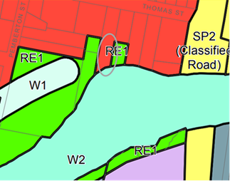
Figure 3 - Zoning of site prior to PLEP 2011 Amendment No.20
Prior to this amendment, 5,057sqm of GFA was permitted under 0.8:1 FSR across the site. The current planning controls allow a maximum of 4,020sqm of GFA is permitted. The Planning Proposal proposed changes in land use zoning boundaries to reflect the developable portions of the site, increase in maximum building height and increase maximum floor space ratio controls. These changes could accommodate approximately 4,973sqm of GFA across the developable site area, which is a lower GFA than what was permissible on the site when the PP was lodged.It also allows for the undevelopable portion of the site to be dedicated for public recreation and natural resources land.
The redevelopment would see 55-59 apartment dwellings accommodated on the site, which is equal to or lower than what was permissible on the site when the Planning proposal was lodged. A change in building height provides opportunities for the previously permissible floor space provision to be accommodated on the site.
3.2. Section B – Relationship to strategic planning framework
This section assesses the relevance of the Planning Proposal to the directions outlined in key strategic planning policy documents. Questions in this section consider state and local government plans including the NSW Government’s Plan for Growing Sydney and subregional strategy, State Environmental Planning Policies, local strategic and community plans and applicable Ministerial Directions.
3.2.1. Will the planning proposal give effect to the objectives and actions of the applicable regional, or district plan or strategy (including any exhibited draft plans or strategies)?
A Metropolis of Three Cities
In March 2018, the NSW Government released the Greater Sydney Region Plan: A Metropolis of Three Cities (“the GSRP”) a 20 year plan which outlines a three-city vision for metropolitan Sydney for to the year 2036.
The GSRP is structured under four themes: Infrastructure and Collaboration, Liveability, Productivity and Sustainability. Within these themes are 10 directions that each contain Potential Indicators and, generally, a suite of objective/s supported by a Strategy or Strategies. Those objectives and or strategies relevant to this planning proposal are discussed below.
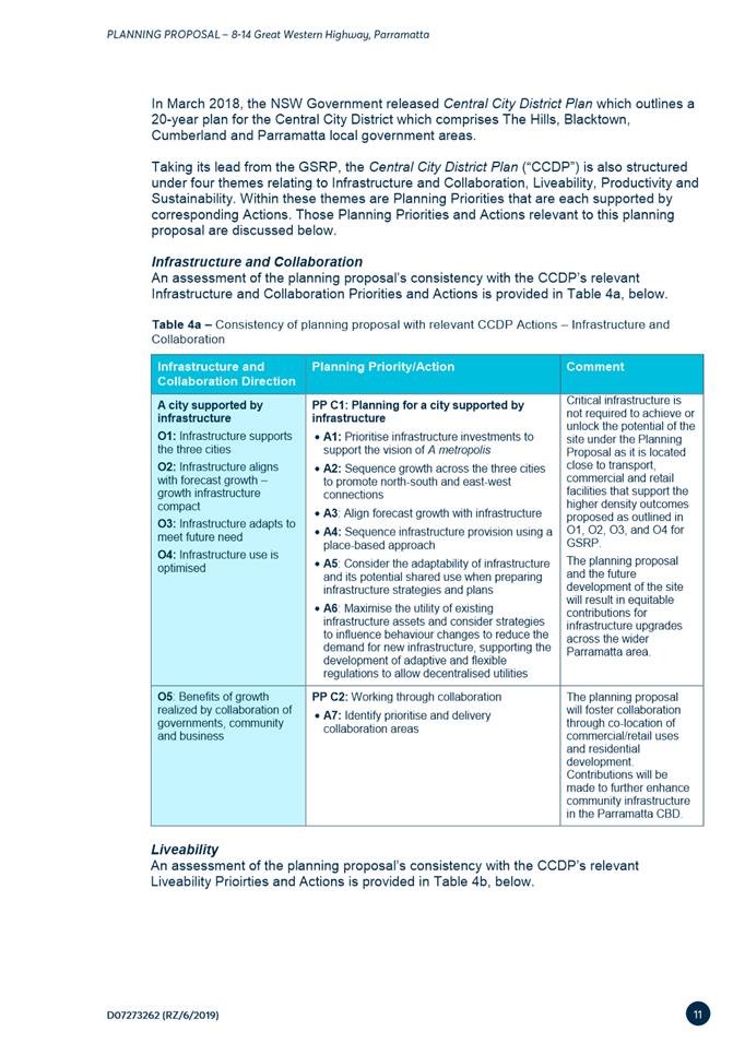
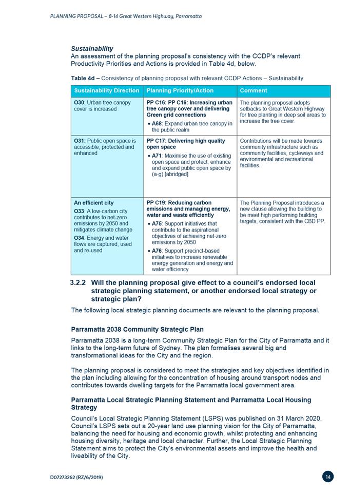
Infrastructure and Collaboration
An assessment of the planning proposal’s consistency with the GSRP’s relevant Infrastructure and Collaboration objectives is provided in Table 3a, below.
Table 3a – Consistency of planning proposal with relevant GSRP Actions – Infrastructure and Collaboration
|
Infrastructure and Collaboration Direction |
Relevant Objective |
Comment |
|
A city supported by infrastructure |
O1: Infrastructure supports the three cities
|
The Region Plan highlights that the Central River City is undergoing a rebuilding program in a high-growth environment, which required existing infrastructure to be optimised. Redevelopment of the existing R4 zoned site in close proximity to James Ruse Drive and Parramatta Valley Cycleway to accommodate a maximum of 6-storey development hopes to maximise the 4,973sqm GFA, which is slightly below the GFA previously permissible on the site prior to PLEP 2011 – Amendment No.20 when the Planning Proposal was lodged. A VPA will also be negotiated aside this Planning Proposal once the strategic parameters and planning controls have been set. |
|
O2: Infrastructure aligns with forecast growth – growth infrastructure compact |
||
|
O3: Infrastructure adapts to meet future need |
||
|
O4: Infrastructure use is optimised |
Liveability
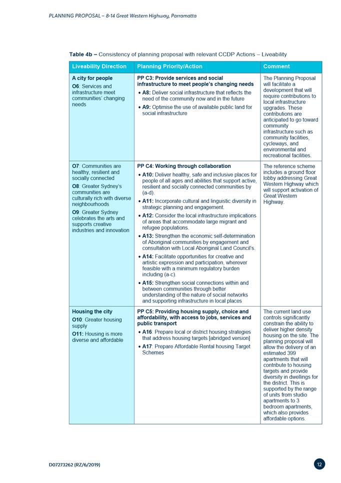
An assessment of the planning proposal’s consistency with the GSRP’s relevant Liveability objectives is provided in Table 3b, below.
Table 3b – Consistency of planning proposal with relevant GSRP Actions – Liveability
|
Liveability Direction |
Relevant Objective |
Comment |
|
A city for people
|
O6: Services and infrastructure meet communities’ changing needs |
The Planning Proposal hopes to optimise land identified for future public open space and existing natural resources (biodiversity & riparian lands and waterways). The PP allocates GFA under a change to zone boundaries for high-density and public recreation land use zones to reflect the developable site area, and increases to maximum HOB and FSR controls to accommodate 4,972sqm, which is slightly below the GFA which could be accommodated on the site when the PP was lodged, prior to PLEP 2011 – Amendment No.20. |
|
O7: Communities are healthy, resilient and socially connected |
||
|
O8: Greater Sydney’s communities are culturally rich with diverse neighbourhoods |
||
|
O9: Greater Sydney celebrates the arts and supports creative industries and innovation |
||
|
Housing the city
|
O10: Greater housing supply |
The subject site is situated outside Council’s already identified growth precincts and currently zoned high-density residential . The PP proposes to accommodate 59 apartment dwellings under an increase in height up to 22m and increase in FSR across the developable portion up to 1.3:1. The PP also removes HOB, FSR and LRA controls for the area identified for land dedication. The reference design accommodates 4,973sqm of high-density residential GFA, which is below what could have been achieved when the PP was lodged. |
|
O11: Housing is more diverse and affordable |
Given the site is already zoned R4 – High Density Residential where residential flat buildings are already permitted, and that the Planning Proposal is not seeking a significant uplift over and above what the site could previously achieve, the Planning Proposal is considered to be consistence with this objective and Council’s LSPS in this instance. It is anticipated that City of Parramatta is expected to meet and potentially exceed its housing targets set by the Greater Sydney Commission, thus the change in planning controls must be justified in accordance with other Liveability Directions. |
|
|
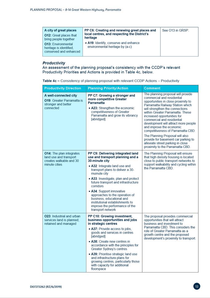
A city of great places |
O12: Great places that bring people together |
The site is situated in close proximity to the Parramatta River, Western Sydney University and the periphery of Parramatta CBD which provide opportunities to future residents for employment, education and recreation. |
|
O13: Environmental heritage is identified, conserved and enhanced |
Parts of the site are identified for natural resources-biodiversity, natural resources – riparian lands and waterways and environmental heritage I1- Wetlands Parramatta River. Future development on the site will be located away from these sensitive environmental areas. |
Productivity
An assessment of the planning proposal’s consistency with the GSRP’s relevant Productivity objectives is provided in Table 3c, below.
Table 3c – Consistency of planning proposal with relevant GSRP Actions – Productivity
|
Productivity Direction |
Relevant Objective |
Comment |
|
A well connected city
|
O14: The plan integrates land use and transport creates walkable and 30 minute cities |
The site is located in close proximity to James Ruse Drive, Parramatta Valley Cycleway which connect to Parramatta CBD nearby. The increase in building height to accommodate high-density residential dwellings supports integrating land use with walkable 30min cities to the Central River City of Parramatta. |
|
O15: The Eastern, GPOP and Western Economic Corridors are better connected and more competitive |
The subject site is located within the Shorts Corner precinct of GPOP. This precinct is not identified for growth as part of Phase 1 or Phase 2 of the Place-based Infrastructure Compact. The PP does not see an increase in residential GFA above what was previously permitted on the site at lodgement of the PP\. |
|
|
Jobs and skills for the city |
O19: Greater Parramatta is stronger and better connected |
This Planning Proposal is generally consistent with the vision under O19 of the region plan. An increase in building height allows for the GFA previously available under the zoning prior to 28 July 2017 to be massed within a 6-storey built form. |
|
O21: Internationally competitive health, education, research and innovation precincts |
The Planning Proposal does not seek to allow for employment floor space. The application adjusts the area boundaries affected by R4 – High Density Residential and RE1 – Public Recreation to reflect the developable areas of the site and land dedication. |
|
|
O22: Investment and business activity in centres |
||
|
O23: Industrial and urban services land is planned, retained and managed |
||
|
O24: Economic sectors are targeted for success |
Sustainability
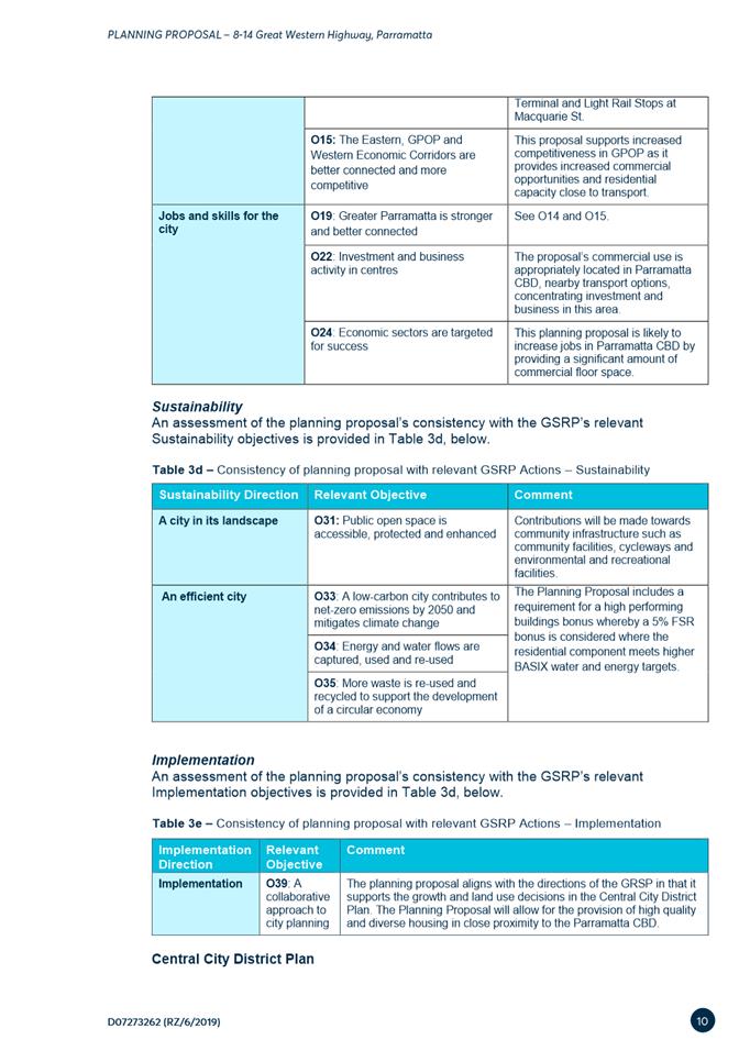
An assessment of the planning proposal’s consistency with the GSRP’s relevant Sustainability objectives is provided in Table 3d, below.
Table 3d – Consistency of planning proposal with relevant GSRP Actions – Sustainability
|
Sustainability Direction |
Relevant Objective |
Comment |
|
A city in its landscape
|
O25: The coast and waterways are protected and healthier |
The subject site included planning affections from Natural Resources – Riparian Lands and Waterways & Biodiversity and the Foreshore Building Line along the southern portion of the site. The reference design locates the future building envelope outside the affected areas on the elevated topography at the north of the site. The southern portion of the site would be rezoned RE1 and dedicated to Council. Concerns were raised in the initial assessment regarding the coastal mangroves and saltmarshes. Department of Primary Industries indicated in November 2017 that “does not see any reason for potential shading issues on mangrove and saltmarsh species to prevent the lodgement of this development, as proposed” |
|
O27: Biodiversity is protected, urban bushland and remnant vegetation is enhanced |
||
|
O28: Scenic and cultural landscapes are protected |
The proposal is situated in close proximity to Parramatta River. A substantial setback is proposed for future development that locates the building out of the Foreshore Building Line, Natural Resources affectation and heritage area. |
|
|
O29: Environmental, social and economic values in rural areas are protected and enhanced |
N/A |
|
|
O30: Urban tree canopy cover is increased |
Deep soil areas are proposed for the front and side setbacks. A site specific DCP proposed to accommodate urban tree canopy cover on the site to enhance the streetscape and improve privacy between neighbouring properties. |
|
|
O31: Public open space is accessible, protected and enhanced |
The subject site includes an acquisition for local open space on No.85 Thomas Street. The subject site is also subject to an easement for the Parramatta Valley Cycleway along the southern edge of the site. |
|
|
O32: The Green grid links Parks, open spaces, bushland and walking and cycling paths |
The subject site already includes elements of the green grid along the southern portion of the site within the natural resourced affected land where the Parramatta Valley cycleway is located. |
|
|
An efficient city |
O33: A low-carbon city contributes to net-zero emissions by 2050 and mitigates climate change |
The proposal does not include sustainability initiatives such as recycled water, sustainable building materials, photovoltaics. Should the proposal proceed, initiatives towards net-zero emission by 2050, methods of recycling construction and ongoing waste should be investigated as part of the Development Application stage. Further consideration should be given to council’s environmental sustainability strategy when delivering the proposal. |
|
O34: Energy and water flows are captured, used and re-used |
||
|
O35: More waste is re-used and recycled to support the development of a circular economy |
||
|
A resilient city |
O36: People and places adapt to climate change and future shocks and stresses |
The proposal does include some flood affected land. However, the proposed building is located away from the land impacted by natural hazards. |
|
O37: Exposure to natural and urban hazards is reduced |
||
|
O38: Heatwaves and extreme heat are managed |
Implementation
An assessment of the planning proposal’s consistency with the GSRP’s relevant Implementation objectives is provided in Table 3d, below.
Table 3d – Consistency of planning proposal with relevant GSRP Actions – Implementation
|
Implementation Direction |
Relevant Objective |
Comment |
|
Implementation |
O39: A collaborative approach to city planning |
The proposal is responding to in depth consultation between Council, the applicant and Department of Primary Industries. |
Central City District Plan
In March 2018, the NSW Government released Central City District Plan which outlines a 20 year plan for the Central City District which comprises The Hills, Blacktown, Cumberland and Parramatta local government areas.
Taking its lead from the GSRP, the Central City District Plan (“CCDP”) is also structured under four themes relating to Infrastructure and Collaboration, Liveability, Productivity and Sustainability. Within these themes are Planning Priorities that are each supported by corresponding Actions. Those Planning Priorities and Actions relevant to this planning proposal are discussed below.
Infrastructure and Collaboration
An assessment of the planning proposal’s consistency with the CCDP’s relevant Infrastructure and Collaboration Priorities and Actions is provided in Table 4a, below.
Table 4a – Consistency of planning proposal with relevant CCDP Actions – Infrastructure and
Collaboration
|
Infrastructure and Collaboration Direction |
Planning Priority/Action |
Comment |
|
A city supported by infrastructure O1: Infrastructure supports the three cities O2: Infrastructure aligns with forecast growth – growth infrastructure compact O3: Infrastructure adapts to meet future need O4: Infrastructure use is optimised |
PP C1: Planning for a city supported by infrastructure · A1: Prioritise infrastructure investments to support the vision of A metropolis · A2: Sequence growth across the three cities to promote north-south and east-west connections · A3: Align forecast growth with infrastructure · A4: Sequence infrastructure provision using a place based approach · A5: Consider the adaptability of infrastructure and its potential shared use when preparing infrastructure strategies and plans · A6: Maximise the utility of existing infrastructure assets and consider strategies to influence behaviour changes to reduce the demand for new infrastructure, supporting the development of adaptive and flexible regulations to allow decentralised utilities |
The site located on Thomas Street is in close proximity to the James Ruse Drive regional route and Parramatta Valley Cycleway. The site may be easily accessed via car, bus or bicycle. The proposal arranges the currently permissible high-density residential use within the northern half of the subject site in hope to utilise the existing assets at the south for natural resources and public open space. |
|
O5: Benefits of growth realized by collaboration of governments, community and business |
PP C2: Working through collaboration · A7: Identify prioritise and delivery collaboration areas |
Liveability
An assessment of the planning proposal’s consistency with the CCDP’s relevant Liveability Prioirties and Actions is provided in Table 4b, below.
Table 4b – Consistency of planning proposal with relevant CCDP Actions – Liveability
|
Liveability Direction |
Planning Priority/Action |
Comment |
|
A city for people O6: Services and infrastructure meet communities’ changing needs |
PP C3: Provide services and social infrastructure to meet people’s changing needs · A8: Deliver social infrastructure that reflects the need of the community now and in the future · A9: Optimise the use of available public land for social infrastructure |
As part of the proposal, the application proposed to dedicate 1,296sqm land at No.85 Thomas Street for public open space as identified in the land reserved for acquisition map and 1,200sqm of land at No.89 and 91 Thomas Street identified for Natural Resources –Riparian Lands and Waterways & Biodiversity for council ownership. |
|
O7: Communities are healthy, resilient and socially connected O8: Greater Sydney’s communities are culturally rich with diverse neighbourhoods O9: Greater Sydney celebrates the arts and supports creative industries and innovation |
PP C4: Working through collaboration · A10: Deliver healthy, safe and inclusive places for people of all ages and abilities that support active, resilient and socially connected communities by (a-d). · A11: Incorporate cultural and linguistic diversity in strategic planning and engagement. · A12: Consider the local infrastructure implications of areas that accommodate large migrant and refugee populations. · A13: Strengthen the economic self-determination of Aboriginal communities by engagement and consultation with Local Aboriginal Land Council’s. · A14: Facilitate opportunities for creative and artistic expression and participation, wherever feasible with a minimum regulatory burden including (a-c). · A15: Strengthen social connections within and between communities through better understanding of the nature of social networks and supporting infrastructure in local places |
The initial application has been referred to the former Department of Primary Industries for comment on the sensitive ecology areas to the south as identified in the Natural Resources and Heritage Map. The input from state government agencies has assisted in preparing a supportable scheme.
Council’s LEP Amendment No.20 relating to Land Reserved for Acquisition has also affected the application identifying parts of the site for public recreation and natural resources biodiviersity/riparian lands and waterways. This impacted the developable of the R4 zoned site. This Planning Proposal hopes to facilitate development in accordance with the intentions of the controls of the site.
|
|
Housing the city O10: Greater housing supply O11: Housing is more diverse and affordable
|
PP C5: Providing housing supply, choice and affordability, with access to jobs, services and public transport · A16: Prepare local or district housing strategies that address housing targets [abridged version] · A17: Prepare Affordable Rental housing Target Schemes |
City of Parramatta is expected to meet and potentially exceed its housing targets set by the Greater Sydney Commission, thus the change in planning controls cannot be justified under O10 which proposes to increase the supply of housing.
A Planning Proposal increasing the maximum building height provides an opportunity for the applicant to obtain Gross Floor Area (GFA) for high-density residential uses from the undevelopable land zoned R4 and, and in this exceptional circumstance the privately owned RE1 portion rezoned by a Council let proposal.
No affordable housing is included in the planning proposal at this stage. The proposal could investigate potential to include future affordable housing stock on the site under Council’s Affordable Housing Policy. |
|
A city of great places O12: Great places that bring people together O13: Environmental heritage is identified, conserved and enhanced |
PP C6: Creating and renewing great places and local centres, and respecting the District’s heritage · A18: Using a place-based and collaborative approach throughout planning, design, development and management deliver great places by (a-e) · A19: Identify, conserve and enhance environmental heritage by (a-c) · A20: Use place-based planning to support the role of centres as a focus for connected neighbourhoods · A21: In Collaboration Areas, Planned Precincts and planning for centres (a-d) · A22: Use flexible and innovative approaches to revitalise high streets in decline. |
The site reference scheme proposed a design that masses the building envelope within the developable portion of the site in the northern half of the site. It provides separation between the development and existing environmental constraints such as the open space acquisition, natural resources area and Parramatta River. |
Productivity
An assessment of the planning proposal’s consistency with the CCDP’s relevant Productivity Priorities and Actions is provided in Table 4c, below.
Table 4c – Consistency of planning proposal with relevant CCDP Actions – Productivity
|
Productivity Direction |
Planning Priority/Action |
Comment |
|
A well-connected city O19: Greater Parramatta is stronger and better connected |
PP C7: Growing a stronger and more competitive Greater Parramatta · A23: Strengthen the economic competitiveness of Greater Parramatta and grow its vibrancy [abridged] · A24: Revitalise Hawkesbury Road so that it becomes the civic, transport, commercial and community heart of Westmead · A25: Support the emergency services transport, including helicopter access · A26: Prioritise infrastructure investment [abridged] · A27: Manage car parking and identify smart traffic management strategies · A28: Investigate opportunities for renewal of Westmead East as a mixed use precinct |
The existing R4 zoned site is located in close proximity to the Parramatta CBD and intends to deliver additional high-density residential dwellings in close proximity to the employment generating uses in Parramatta CBD.
Redevelopment for high-density residential uses on the site is subject to significant environmental and topographic restraints to the southern portion of the site. The Planning Proposal, site-specific DCP and draft VPA endeavour to address the highly restrained environmental condition of the site within an R4 zoning in close proximity to Parramatta CBD. |
|
Jobs and skills for the city O15: The Eastern, GPOP and Western Economic Corridors are better connected and more competitive
|
PP C8: Delivering a more connected and competitive GPOP Economic Corridor · A28: Investigate opportunities for renewal of Westmead East as a mixed use precinct PPC8 · A29: Prioritise public transport investment to deliver the 30-minute city objective for strategic centres along the GPOP Economic Corridor · A30: Prioritise transport investments that enhance access to the GPOP between centres within GPOP |
The proposal maintains the existing R4 – High Density Residential zone for the subject site across the developable area at the northern porton of the site along the street, and extends the existing RE1 –Public Recreation use across the undeveloped site area which is proposed for land dedication. The site is located within the GPOP corridor and in a location near local bus routes, regional highways and local cycleways that supports the 30-minute city. |
|
O14: The plan integrates land use and transport creates walkable and 30 minute cities
|
PP C9: Delivering integrated land use and transport planning and a 30-minute city · A32: Integrate land use and transport plans to deliver a 30-muinute city · A33: Investigate, plan and protect future transport and infrastructure corridors · A34: Support innovative approaches to the operation of business, educational and institutional establishments to improve the performance of the transport network · A35: Optimise the efficiency and effectiveness of the freight handling and logistics network by (a-d) · A36: Protect transport corridors as appropriate, including the Western Sydney Freight Line, North South train link from Schofields to WS Airport as well as Outer Sydney Orbital and Bells Line of Road-Castlereagh connections |
|
|
O23: Industrial and urban services land is planned, retained and managed |
PP C10: Growing investment, business opportunities and jobs in strategic centres · A37: Provide access to jobs, goods and services in centres [abridged] · A38: Create new centres in accordance with the principles for Greater Sydney’s centres · A39: Prioritise strategic land use and infrastructure plans for growing centres, particularly those with capacity for additional floorspace |
The Planning Proposal would locate additional housing in close proximity to the Parramatta CBD. It is anticipated that additional housing will grow investment and business opportunities for everyday retail and commercial uses at the site and is therefore consistent with PP C10. |
|
O23: Industrial and urban services land is planned, retained and managed |
PP C11: Maximising opportunities to attract advanced manufacturing and innovation in industrial and urban services land
|
N/A |
|
O24: Economic sectors are targeted for success |
PP C12: Supporting growth of targeted industry sectors
|
N/A |
Sustainability
An assessment of the planning proposal’s consistency with the CCDP’s relevant Productivity Prioirties and Actions is provided in Table 4d, below.
Table 4d – Consistency of planning proposal with relevant CCDP Actions – Sustainability
|
Sustainability Direction |
Planning Priority/Action |
Comment |
|
A city in its landscape O25: The coast and waterways are protected and healthier |
PP C13: Protecting and improving the health and enjoyment of the District’s Waterways · A60: Protect environmentally sensitive areas of waterways · A61: Enhance sustainability and liveability by improving and managing access to waterways and foreshores for recreation, tourism, cultural events and water based transport · A62: Improve the health of catchments and waterways through a risk based approach to managing the cumulative impacts of development including coordinated monitoring of outcomes · A63: Work towards reinstating more natural conditions in highly modified urban waterways |
The proposal is situated adjacent to Parramatta River. A substantial setback is proposed for future development that locates the building out of the Foreshore Building Line, Natural Resources affectation and heritage area. The reference design proposed positions future development outside the affected areas on the elevated topography at the north of the site. |
|
O26: The coast and waterways are protected and healthier |
PP C14: Creating a Parkland City urban structure and identity, with South Creek as a defining spatial element · A64: Implement South Creek Corridor Project and use the design principles for South Creek to deliver a cool and green Western Parkland City |
The subject site is adjacent to the Parramatta River and impacted by the Coastal Management SEPP 2018. The Foreshore Building Line in the LEP also affects the subject site. |
|
O27: Biodiversity is protected, urban bushland and remnant vegetation is enhanced O28: Scenic and cultural landscapes are protected |
PP C15: Protecting and enhancing bushland, biodiversity and scenic and cultural landscapes · A65: Protect and enhance biodiversity by (a-c) [abridged] · A66: Identify and protect scenic and cultural landscapes · A67: Enhance and protect views of scenic and cultural landscapes from the public realm |
The subject site includes urban bushland which is classified as Natural Resources – Riparian Lands and Waterways. This has been taken into consideration when preparing the reference design for the planning proposal, which includes both developable and undevelopable portions to the site. |
|
O30: Urban tree canopy cover is increased O32: The Green grid links Parks, open spaces, bushland and walking and cycling paths |
PP C16: PP C16: Increasing urban tree canopy cover and delivering Green grid connections · A68: Expand urban tree canopy in the public realm · A69: progressively refine the detailed design and delivery of (a-c) [abridged] · A70: Create Greater Sydney green Grid connections to the Western Sydney Parklands |
The subject site already includes urban tree canopy within the southern portion of the site. This area is anticipated to be maintained as existing as part of the planning proposal.
Deep soil areas are proposed for the front and side setbacks. A site specific DCP proposed to accommodate urban tree canopy cover on the site to enhance the streetscape and improve privacy between neighbouring properties. |
|
O31: Public open space is accessible, protected and enhanced |
PP C17: Delivering high quality open space · A71: Maximise the use of existing open space and protect, enhance and expand public open space by (a-g) [abridged] |
The subject site includes an acquisition for local open space on No.85 Thomas Street. The subject site is also subject to an easement for the Parramatta Valley Cycleway along the southern edge of the site. The easement will be maintained as part of the future development.
The Planning Agreement Offer also includes land dedication for the existing RE1 land affected by a land acquisition (1,296sqm) and natural resources biodiversity land (1,200sqm). |
|
An efficient city O33: A low-carbon city contributes to net-zero emissions by 2050 and mitigates climate change O34: Energy and water flows are captured, used and re-used O35: More waste is re-used and recycled to support the development of a circular economy |
PP C19: Reducing carbon emissions and managing energy, water and waste efficiently · A75: Support initiatives that contribute to the aspirational objectives of achieving net-zero emissions by 2050 · A76: Support precinct-based initiatives to increase renewable energy generation and energy and water efficiency · A77: Protect existing and identify new locations for waste recycling and management · A78: Support innovative solutions to reduce the volume of waste and reduce waste transport requirements · A79: Encourage the preparation of low carbon, high efficiency strategies to reduce emissions, optimise the use of water, reduce waste and optimising car parking provisions where an increase in total floor in 100,000sqm |
The proposal does not include sustainability initiatives such as recycled water, sustainable building materials, photovoltaics. Should the proposal proceed, initiatives towards net-zero emission by 2050, methods of recycling construction and ongoing waste should be investigated as part of the Development Application stage. Further consideration should be given to council’s environmental sustainability strategy when delivering the proposal. |
|
O36: People and places adapt to climate change and future shocks and stresses O37: Exposure to natural and urban hazards is reduced O38: Heatwaves and extreme heat are managed |
PP C20: Adapting to the impacts of urban and natural hazards and climate change · A81: Support initiatives that respond to the impacts of climate change · A82: Avoid locating new urban development in areas exposed to natural and urban hazards and consider options to limit the intensification of development in existing areas most exposed to hazards · A83: Mitigate the urban heat island effect and reduce the vulnerability to extreme heat · A84: Respond to the direction for managing flood risk in Hawkesbury-Nepean Valley · A85: Consider strategies and measures to manage flash flooding and safe evacuation when planning for growth in Parramatta CBD |
The proposal does include some flood affected land. However, the proposed building envelope in the reference design is located away from the land impacted by natural hazards. |
3.2.1. Will the planning proposal give effect to a council’s endorsed local strategic planning statement, or another endorsed local strategy or strategic plan?
The following local strategic planning documents are relevant to the planning proposal.
Parramatta 2038 Community Strategic Plan
Parramatta 2038 is a long term Community Strategic Plan for the City of Parramatta and it links to the long-term future of Sydney. The plan formalises several big and transformational ideas for the City and the region. The planning proposal is considered to meet the strategies and key objectives identified in the plan including:
· 3.4 Provide green spaces for recreation, relaxation and enjoyment
· 6.1 Engage in strategic planning and implement innovative solutions to manage the growth of our city
Parramatta Local Strategic Planning Statement
The LSPS sets out the long-term vision for land use planning in a council’s local government area (LGA) and responds to broader priorities identified in the District Plans and integrates with a Council’s Community Strategic Plan. The LSPS will provide greater weight to strategic planning in the broader plan making process and any new planning proposal must justify any inconsistency with this framework.
The Planning Proposal is assessed against the broad directions of the LSPS as shown below in Table 5.
Table 5: LSPS Assessment
|
Broad Directions of LSPS |
Comment |
|
1. Focus employment growth in the Parramatta Metropolitan Centre (Parramatta CBD) and Strategic Centres of Epping and Sydney Olympic Park and Westmead Innovation Precinct |
N/A |
|
2. Housing growth is focused in identified Growth Precincts |
The site is not within an already identified housing growth precinct in Council’s LSPS, Council’s LHS or the GPOP Place-based infrastructure compact. The site is already zoned R4 – High Density Residential. Prior to Parramatta LEP 2011 – Amendment No.20, the entire 6,321sqm of privately owned land had a 0.8:1 FSR allowing up to 5057sqm of GFA . This Planning Proposal redistributes that previously available floorspace within the developable portion of the site (3,825sqm) in an increased height limit of 22m and increase FSR of 1.3:1 applying to the R4 land.
|
|
3. Preserve and enhance the low-scale character and identity of suburban City of Parramatta suburbs outside of the GPOP area |
Residential flat buildings are already a permissible use on the subject site. The planning proposal does not propose to change the R4 zoning of the developable portion of the site. The reference design provides substantial setbacks exceeding what would be required by the Apartment Design Guide to better protect the amenity and privacy of adjoin R4 zoned sites, some which still include single dwelling houses (north of Thomas St). There additional setbacks allow for deep soil and urban tree canopy cover. |
|
4. Stage Housing Release with infrastructure delivery. |
The site is situated within the “Shorts Corner” precinct, which is not identified as an area for prioritised growth in the short to medium term. Notwithstanding, the Planning Proposal does not propose a significant increase in GFA compared to what was achievable on the site prior to the recent rezoning under Parramatta LEP 2011 – Amendment 20 that introduced RE1 zoning, land acquisition and biodiversity controls on the site. Therefore it is considered by Council officers that the Planning Proposal should proceed despite the recommendation of the draft PIC |
|
5. Housing Diversity underpins any future changes to planning controls |
Given the site is already zoned R4 – High Density Residential and that the Planning Proposal is not seeking a significant uplift over and above what the site could previously achieve, the Planning Proposal is considered to be consistence with the LSPS in this instance. |
|
6. The majority of employment lands are protected to ensure no net loss of jobs or employment lands |
N/A |
|
7. Neighbourhoods, places and development are well-balanced, connected and sustainable |
No affordable housing is included in the planning proposal at this stage. Council’s Affordable Housing Policy provides opportunities to work towards well-balanced and sustainable development. |
|
8. Protection of the environment, including providing for sustainable development |
The subject site has an existing easement for the Parramatta Valley cycleway along the southern portion of the site to assist in providing Green grid and River foreshore connections. The site also includes a 30m Foreshore Building Line, within that area includes Natural Resources – Biodiversity and Natural Resources – Riparian Lands and Waterways affectations. There is also a land acquisition affectation at the No.85 Thomas Street site for privately owned land currently zoned RE1. Opportunity to designate privately owned RE1 land undevelopable land to public open space and land affected by Natural Resources Riparian Lands & Waterways and Biodiversity will be negotiated as part of a future VPA. |
Parramatta Local Housing Strategy
Council is also required to prepare a Local Housing Strategy (LHS) in accordance with the Central City District Plan. The LHS will convey the type and location of new housing in the City of Parramatta LGA. It will consider supply and demand for housing, local land use opportunities and constraints, demographic factors and appropriate building typologies to support a mix of housing.
Table 6: Draft LHS Assessment
|
Key Findings of Draft LHS |
Comment |
|
Finalise Parramatta CBD Planning Proposal and Granville (South) Planning Proposal (Parramatta Road Urban Transformation Strategy). |
The subject site is located outside the Parramatta CBD and Granville Precinct. As mentioned previously, the increase in building height allows the landowner to accommodate the 4,973sqm of apartment dwelling floorspace permissible on the site prior to 28 July 2017 when Parramatta LEP 2011 – Amendment No.20 was gazette. |
|
Implement Westmead Innovation District Master Plan. |
N/A |
|
Continue housing delivery in already zoned precincts and their related site-specific planning proposals. |
The subject site is already zoned R4 and does not lead to additional high-density residential floor space outside the already identified growth precincts than that currently permissible by the site area and FSR prior to 28 July 2017. |
|
Investigate more medium density, low-rise housing types (terraces and townhouses) in suitable locations. |
Residential flat buildings are already a permissible use on the subject site. The planning proposal does not propose to change the R4 zoning of the developable portion of the site and terraces and townhouses cannot be mandated for the site. |
|
Pursue an Affordable Housing Scheme for new Growth Precinct Planning Proposals. |
No affordable housing is included in the planning proposal at this stage. The proposal could investigate potential to include future affordable housing stock on the site under Council’s Affordable Housing Policy. |
|
Complete structure plan and design guidelines for all Growth Precincts. |
The site is outside the identified structure plan areas for growth precincts. The application currently proposes a scale of development that does not trigger the need to prepare precinct wide analysis from high-density residential zone land in the nearby area bound by James Ruse Drive, Parramatta River, Macarthur Street and Victoria Road. |
Both the LSPS and LHS will be used in the future to set a strategic framework for future housing and guide the planning in this area, across the LGA and are likely to come into effect in 2020. Given that the site has existing R4 zoning, the LSPS and LHS are unlikely to preclude redevelopment for high-density residential uses such as apartments on the site. Council officers recommend that the Planning Proposal be updated following Gateway Determination and prior to public exhibition to reflect the final Local Housing Strategy as endorsed by Council in mid 2020.
3.2.2. Is the planning proposal consistent with the applicable State Environmental Planning Policies?
The following State Environmental Planning Policies (SEPPs) are of relevance to the site (refer to Table 5 below).
Table 5 – Consistency of planning proposal with relevant SEPPs
|
State Environmental Planning Policies (SEPPs) |
Consistency: Yes = ✓ No = x N/A = Not applicable |
Comment |
|
SEPP No 1 Development Standards |
N/A |
SEPP 1 does not apply to Parramatta LEP 2011 |
|
SEPP 4 – Development Without Consent and Miscellaneous Exempt and Complying Development |
N/A |
This SEPP is not applicable to the subject land under Clause 1.9 of the Parramatta LEP 2011. |
|
SEPP 6 – Number of Storeys in a Building |
N/A |
Standard instrument definitions apply. |
|
SEPP 33 – Hazardous and Offensive Development |
x |
This SEPP is not applicable to the subject land under Clause 1.9 of the Parramatta LEP 2011. |
|
SEPP No 55 Remediation of Land
|
x |
This SEPP is not applicable to the subject land under Clause 1.9 of the Parramatta LEP 2011. |
|
SEPP 60 – Exempt and Complying Development |
N/A |
This SEPP is not applicable to the subject land under Clause 1.9 of the Parramatta LEP 2011. |
|
SEPP 64 – Advertising and Signage |
N/A |
Not relevant to proposed amendment. May be relevant to future DAs. |
|
SEPP No 65 Design Quality of Residential Flat Development
|
✓ |
Detailed compliance with SEPP 65 will be demonstrated at the time of making a development application for the site facilitated by this Planning Proposal. During the design development phase, detailed testing of SEPP 65 and the Residential Flat Design Code was carried out and the indicative scheme is capable of demonstrating compliance with the SEPP. |
|
SEPP No.70 Affordable Housing (Revised Schemes) |
N/A |
Not relevant to proposed amendment. |
|
SEPP (Affordable Rental Housing) 2009 |
N/A |
Not relevant to proposed amendment. |
|
SEPP (BASIX) 2004 |
N/A |
Detailed compliance with SEPP (BASIX) will be demonstrated at the time of making a development application for the site facilitated by this Planning Proposal. |
|
SEPP (Exempt and Complying Development Codes) 2008 |
✓ |
May apply to future development of the site. |
|
SEPP (Infrastructure) 2007 |
x |
May apply to future development of the site. |
|
Sydney Regional Environmental Plan No 18–Public Transport Corridors |
N/A |
This SEPP is not applicable to the subject land under Clause 1.9 of the Parramatta LEP 2011. |
|
Sydney Regional Environmental Plan (Sydney Harbour Catchment) 2005
|
N/A
|
The proposed development is not located directly on the Sydney Harbour Catchment foreshore. Any potential impacts as a result of development on the site, such as stormwater runoff, will be considered and addressed appropriately at DA stage. |
|
SEPP (Urban Renewal) 2010 |
x |
N/A |
|
SEPP Coastal Management |
✓ |
This applies to this site as it adjoins ‘Coastal Wetlands’ and is located within the 100m buffer zone of the Mean High Water Mark of the Parramatta River. The Coastal SEPP gives effect to the objectives of the Coastal Management Act 2016, defining the four coastal management areas as per the Act through detailed mapping and specific assessment criteria for each coastal management area as outlined in the attached Fact Sheet. Councils must consider these criteria when assessing proposals for development that fall within one or more of the mapped areas |
3.2.3. Is the planning proposal consistent with applicable Ministerial Directions (s.9.1 directions)
In accordance with Clause 9.1 of the EP&A Act 1979 the Minister issues directions for the relevant planning authorities to follow when preparing planning proposals for new LEPs. The directions are listed under the following categories:
· Employment and resources
· Environment and heritage
· Housing, infrastructure and urban development
· Hazard and risk
· Housing, Infrastructure and Urban Development
· Local plan making
The following directions are considered relevant to the subject Planning Proposal.
Table 6 – Consistency of planning proposal with relevant Section 9.1 Directions
|
Relevant Direction |
Comment |
Compliance |
|
1. Employment and Resources |
||
|
2. Environment and Heritage |
||
|
Direction 2.2 – Coastal Management |
The subject site is located within the coastal zone as identified by the SEPP and Coastal Management Act. The planning proposal does not intensify the land use towards the southern portion of the site as this is proposed for land dedication to Council. This will provide better consistency with this SEPP. |
Yes |
|
Direction 2.3 - Heritage Conservation
|
The subject site contains part of I1 – Coastal Wetlands, Parramatta River. Council is satisfied that the planning proposal maintains the integrity of the item can be maintained under the proposed indicative massing within the developable portion of the site.
|
Yes |
|
3. Housing, Infrastructure and Urban Development |
||
|
Direction 3.1 - Residential Zones
|
The Planning Proposal is consistent with this direction, in that it: · facilitates additional housing in close proximity to the Parramatta City Centre that is currently not provided on the site · provides residential development in an existing urban area that will be fully serviced by existing infrastructure · does not reduce the permissible residential density of land, but does reduce the amount of residential land. |
Yes |
|
Direction 3.4 - Integrating Land Use and Transport
|
The Planning Proposal is consistent with this direction, in that it: · will provide new dwellings in close proximity to existing bus and bicycle transport links · will enable residents to walk or cycle to work if employed in the Parramatta City Centre or utilise the heavy rail service. · will maintain and provide additional commercial premises in proximity to existing transport links · makes more efficient use of space and infrastructure by increasing densities on an underutilised site. |
Yes |
|
4. Hazard and Risk |
||
|
Direction 4.1 - Acid Sulfate Soils
|
The site is identified as Class 5 on the Acid Sulfate Soils and part Class 2 on the Map in Parramatta Local Environmental Plan 2011. Acid sulfate soils are generally not found in Class 5 areas. However, this will be addressed further at the development application stage. Buildings will not be located in the Class 2 area. |
Yes |
|
Direction 4.3 - Flood Prone Land
|
Any potential impacts as a result of development on the site, such as stormwater runoff, will be considered and addressed appropriately at DA stage. This will also include any design detail required to ensure compliance with Council’s water management controls within the Parramatta DCP 2011. |
Yes |
|
5. Local Plan Making |
||
|
Direction 6.1 - Approval and Referral Requirements
|
The Planning Proposal does not introduce any provisions that require any additional concurrence, consultation or referral. |
Yes |
|
Direction 6.2 – Reserving Land for Public Purposes |
The subject site includes a land reserved for acquisition affectation on No.85 Thomas Street. This portion of land is already zoned RE1 and proposed to be dedicated to Council as part of the Planning Proposal process. Future development under the reference design does not proposed high-density residential development within this portion of the site. |
Yes |
|
Direction 6.3 - Site Specific Provisions
|
The Planning Proposal does not introduce any site specific provisions. |
Yes |
|
6. Metropolitan Planning |
||
|
Direction 7.1 - Implementation of A Plan for Growing Sydney
|
This direction works towards ensuring planning proposals are consistent with the metropolitan region plan. In doing so, an assessment of the planning proposal has been carried out with regards to the GSC’s A Metropolis of Three Cities. This has been included above as part of the relationship to strategic planning framework under Section B. |
Yes |
|
Direction 7.5 – Implementation of Greater Parramatta Priority Growth Area Interim Land Use and Infrastructure Implementation Plan
|
The Planning Proposal is not located within the Greater Parramatta Priority Growth Area Interim Land Use and Infrastructure Implementation Plan although is located within close proximity of the area.
The subject site is located within the Shorts Corner precinct of GPOP. This precinct is not identified for growth as part of Phase 1 or Phase 2 of the Place-based Infrastructure Compact. |
Yes |
3.3. Section C – Environmental, social and economic impact
This section considers the potential environmental, social and economic impacts which may result from the Planning Proposal.
3.3.1. Is there any likelihood that critical habitat or threatened species, populations or ecological communities, or their habitats, will be adversely affected as a result of the proposal?
Yes, the subject site identifies 1,200sqm of land at the southern part of No.89 and 91 Thomas Street be identified as part of the Natural Resources – Biodiversity and Natural Resources – Riparian Lands and Waterways. This land remains zoned R4 with maximum building height and floor space ratios still applying to the land but is undevelopable for high-density residential purposes. The affectation of the site consequent to on 28 July 2017, Parramatta LEP 2011 – Amendment No.20.

Figure 4 & 5- Subject site and land affectation by Natural Resources – Riparian Lands and Waterways (left) and Biodiviersity (right)
3.3.2. Are there any other likely environmental effects as a result of the planning proposal and how are they proposed to be managed?
Heritage
The subject site is affected by the heritage associated with the Parramatta River Wetlands (Item 1 – Schedule 5, Environmental Heritage). This item is located within the undevelopable portion of the site and relates principally to the adjacent Parramatta River. Should the Planning Proposal proceed, land identified as part of heritage will be dedicated to Council ownership.
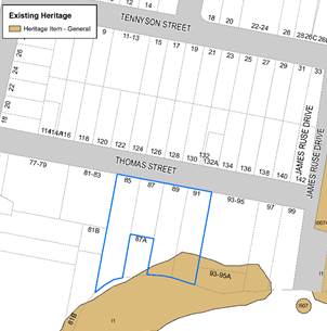
Figure 6 - Heritage affection on subject site by I1 – Parramatta River
The current Planning Proposal proposes that the building envelope is located outside the area affected by Heritage in hope to resolve the heritage and ecological concerns. The Planning Proposal will be referred again to Heritage regarding the heritage and wetland matters as part of a public exhibition associated with a Gateway Determination should the Planning Proposal proceed.
Ecology
Adjacent to the site also includes coastal mangroves and saltmarshes. The Planning Proposal was referred to the former Department of Primary Industries in 2017 seeking comment regarding potential shading impacts to marine vegetation such as the mangroves and saltmarsh to the south of the site. On 15 May 2017, Primary Industries recommended a precautionary approach regarding the ongoing long-term impacts to both the mangroves and saltmarsh. The applicant then provided a revised report which allowed Primary Industries to complete a further assessment. Primary Industry clarified on 9 November 2017 that there “does not see any reason for potential shading issues on mangrove and saltmarsh species to prevent the lodgement of this development, as currently proposed, as a Planning Proposal.
Former concepts for the planning proposal that proposed an increase in GFA for the site raised concerns for Council’s Natural Resources and Open Space team. Caution was raised as an increase in density for the site could set a planning precedent for planning controls to change for the wider precinct which would result cumulative overshadowing impact to the mangroves and salt-marshes. Whilst the Planning Proposal still seeks an increase in height and may increase overshadowing to this ecology, Council officers consider this risk as resolved it satisfies as the planning precedent issue is resolved and an increase in density for this site in isolation (no net-increase in floor-space compared to 2016 controls) is satisfactory.
Flooding
The site is located adjacent to the Parramatta River and includes a steep topography upwards towards Thomas street. The northern part of the site is relatively flat above RL-12. Land towards the south of the site identified for potential land dedication to Council is more susceptive to flooding impacts.
Any potential impacts as a result of development on the site, such as stormwater runoff, will be considered and addressed appropriately at DA stage. This will also include any design detail required to ensure compliance with Council’s water management controls within the Parramatta DCP 2011.
Urban Design
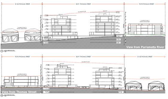
Figure 7- Reference Design for subject site (Source: PTI Architecture)
On 4 February 2020, the applicant provided Council a revised reference design for the Planning Proposal for 85-91 Thomas Street, Parramatta. The applicant’s reference design proposes a 25-metre Maximum Building Height which could accommodate approximately 7 storeys. Council’s Planning and Design units have maintained their recommendation that there is strategic merit in increasing the height to a maximum of 6 storeys to accommodate a similar amount of high-density residential floor-space permissible on the site at lodgement of the Planning Proposal.
Floor Space Ratio
The current scheme submitted by the applicant generates 4,994sqm of GFA for high-density residential purposes. This amount is 953sqm greater than what the current planning controls allow. It is also 63sqm less than the GFA permissible on the site at lodgement in June 2016 where a 0.8:1 FSR control applying to the entire site area (i.e. 5,057sqm of GFA). The Planning Proposal aims to amend the maximum Building Height and Floor Space Ratio controls to accommodate no-net increase in high-density residential GFA compared to what was previously permissible under Development Application controls on the site at lodgement of the application. Therefore the dwelling yield, while increasing compared to the current controls, will be the same when compared to the planning controls which applied to the site when the Planning Proposal was lodged with Council.
Building Height
The existing building height control allows for high-density residential development of maximum 3-storeys to be accommodated on the site. The adjoining property at 93-95 Thomas Street demonstrates a recent example of what could be developed under the existing planning controls (DA/630/2012). This neighbouring development is able to comfortably achieve the current maximum FSR within the existing building height as it does not need to respond to the topographic constraints and foreshore building line evident on the subject site, which significantly reduces the developable area of the subject site.
The applicant’s Planning Proposal proposes a 25-metre Maximum Building Height which could accommodate approximately 7 storeys. This height limit is considered excessive given the reference design proposes only 6-storey development on the site. Figure 8 and 9 show that a 22m height plan can accommodate the reference design and reasonably achieve a 6-storey development despite the sloping topography. The 6-storey height is supportable with a 4-storey street wall, additional setbacks for 5th & 6th storeys and separation to adjacent development. The reference design accommodates a 3.3m variation between the proposed ground level at Thomas Street (RL 14.5m) and lower ground level at the rear (RL 11.2m). This maintains a 4-storey form at street level and no more than 6-storeys across the site.
Part 3.1 of the Parramatta DCP 2011 provides a preliminary building envelope guide recommends a 20m height limit for 6-storey residential flat buildings, with this assessment taking into consideration the sloping topography of the site to inform an appropriate building height. The applicant has revised their concept design to a building envelope of maximum 6-storeys, however still proposes a maximum building height of 25 metres. This height limit is considered onerous for a 6-storey development on the site, with a revised increase in height up to 22m for approximately 6 storeys for the following reasons:
i. It represents a 10% variation from 20m in the DCP Preliminary Building Envelope recommendation for 6-storey residential flat buildings,
ii. It is double the existing HOB control which would allow the currently permissible high-density residential floorspace on the southern half of the site (located in the foreshore building line) to be massed in a taller built form,
iii. It accommodates the 3.3m variation between the proposed ground level at Thomas Street (RL 14.5m) and lower ground level at the rear (RL 11.2m). This maintains a 4-storey form at street level and no more than 6-storeys across the site.
iv. Rooftop gardens above a 6th storey to inform a 25 metres HOB are not certain and could lead to a 7th storey being accommodated.
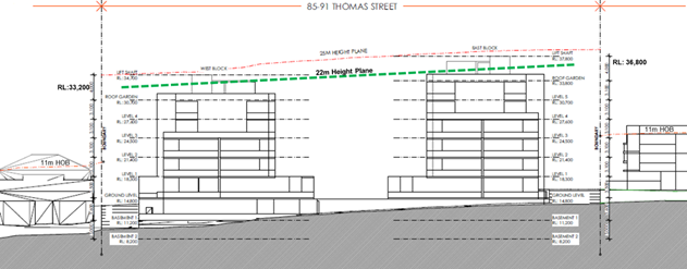
Figure 8 – Section facing north from Parramatta River with adjacent properties (Source: PTI Architecture)
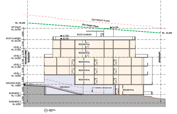
Figure 9– Section facing east from adjacent townhouse development (Source: PTI Architecture)
Building Separation & Setbacks
Given the potential increase in building height on the subject site, it is important to carefully manage privacy and amenity impacts on the adjacent properties, particularly the adjacent townhouse development located near the boundary at 81-83 Thomas Street and single dwelling houses on the northern side of Thomas Street.
The Apartment Design Guide and SEPP 65 set the minimum standards for building separation and setbacks for any residential flat building development on the site. Currently, the ADG would require a minimum of 9 metres separation between habitable and non-habitable rooms for buildings up to 4 storeys, and minimum of 12 metres for buildings 5 to 8 storeys. The reference design included as part of this planning proposal seeks to provide:
· Street setback of 6 metres up to 4-storeys, 9 metre setback up to 6-storeys, 10 metre for rooftop
· Side setback of 10 metres up to 4-storeys, 12 metre setback up to 6-storeys, 13 metre for rooftop.
· Minimum 12 metre building separation between west and east block apartment buildings,
· Rear setback of 3 metres to edge of developable portion of site and foreshore building line,
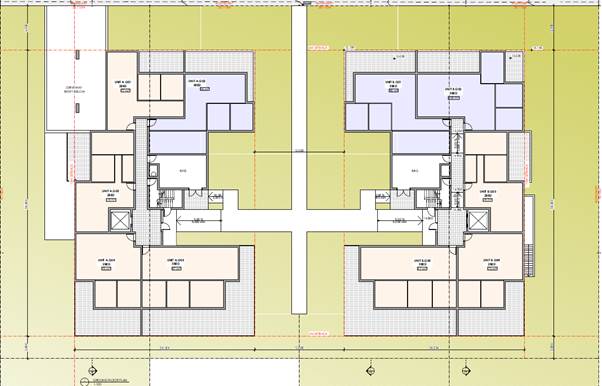
Figure 10 – Ground Floor Setbacks for developable site area
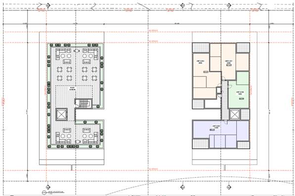
Figure 11 – Level 5 and 6 Setbacks developable site area
Deep soil areas and tree plantings within 6 metres of the front and side property boundary will be required to further improve the relationship of the site with neighbouring buildings. This hopes to provide a satisfactory interface with adjacent properties and satisfy concerns relating to privacy and amenity. The setbacks proposed under the reference design are supportable by Council officers in addressing the privacy and amenity of neighbouring and future residents. These setback standards will be reinforced by a proposed site-specific DCP.
Future development on the site proposes to amalgamate the 4 lots subject to the Planning Proposal. Amalgamation of the sites is supported if the proposed development addresses the scale of adjacent development (such as the townhouses, existing apartment building and single dwellings) and rhythm of the surrounding subdivision pattern with adequate building separation and setbacks exceeding the Apartment Design Guide requirements . Previous concept designs demonstrated a singular elongated row building, driveway and basement entry outside the building envelope, building within the foreshore building line, no additional setback for floors above 4-storeys, are not supported due to their adverse impacts on neighbouring properties and surrounding streetscape. The modulation of the façade will be supported by landscaping and further design detail at Development Application stage as guided by the site specific DCP. The current concept design includes two apartment blocks spaced evenly across the 4 lots, with additional front and side setbacks for Level 5 and 6 which provide a transitioning scale and separation to the scale of development and is supportable (see Figure 11).
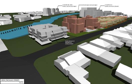
Figure 11 – Indicative streetscape
3.3.3. How has the planning proposal adequately addressed any social and economic effects?
Council and State Government does not identify Thomas Street, and this part of Parramatta (Short’s Corner) as a growth precinct in accordance with Council’s Draft Local Housing Strategy and GSC’s Draft Place-based Infrastructure Compact. No major rezonings are required in this precinct for housing are likely to be made by City of Parramatta to meet the 5 year and 20 year housing targets. Any new proposals for new precincts must be justified under strategic planning objectives other than housing supply.
The Planning Proposal, draft site-specific Development Control Plan and draft Planning Agreement are informed by 2,496sqm of land dedication proposed which relates to the southern part of the site. Some of this land is identified for biodiversity and riparian lands (1,200sqm) and some for local open space (1,296sqm). Land dedication is supported in principle as part of the planning proposa.
3.4. Section D – State and Commonwealth Interests
3.4.1. Is there adequate public infrastructure for the planning proposal?
On 7 November 2019, the GSC released the draft Place-based Infrastructure Compact (PIC) for the Greater Parramatta and Olympic Peninsula (GPOP) area. Specifically, the PIC outlines a draft-sequencing plan to support GPOP and growth in certain precincts in order to inform capital investment plans and budget processes of NSW Government agencies. The site is situated within the “Shorts Corner” precinct, which is not included as part of Phase 1 or Phase 2 areas and therefore not identified for growth within the GPOP (see page 45 and 47, PIC). This makes an increase in density above the 0.8:1 FSR across the whole site area difficult to support.
The Planning Proposal is being facilitated so the applicant may accommodate the 4,655sqm of intended GFA for the subject site as intended by the R4 zoning of the site. It decants the GFA from land zoned R4 outside the Foreshore Building Line, Natural Resources area and Land Reserved for Acquisition which makes most of the undevelopable land. Should the applicant intend to dedicate the 2,496sqm of undevelopable land to Council, the Floor Space Ratio for the site would increase from 0.8:1 to 1.2:1 FSR. Council officers support the massing of GFA within a 6-storey dual building envelope, requiring an increase in maximum HOB from 11m to 22m. Floor Space Ratio and Maximum Building Heights will be removed from the undevelopable portion of the land which is proposed for RE1 zoning.
There is likely to be a modest land value uplift given that no additional floor-space is proposed as part of the application. A base-value for the land is also difficult to identify given the 1,296sqm portion at No.85 Thomas Street was zoned R4 at lodgement, and RE1 at pre-Gateway reporting stage.
The VPA also provides a no-cost pathway for Council to become owners of the RE1 land. This removes the acquisition burden and potentially greater cost for Council to acquire the land from the landowner. It is uncertain whether that this offer is consistent with Council’s Planning Agreement’s Policy which seeks to capture 50% of the value uplift for sites outside of the Parramatta CBD. The dedication of the RE1 land is considered a supportable public benefit that outweighs the cost of assessing and completing a peer-review process of a valuation report for a planning proposal that does not propose additional high-density residential floorspace. The land value uplift process is considered an unreasonable expectation for this application and the VPA offer is acceptable in principle only.
3.4.2. What are the views of State and Commonwealth public authorities consulted in accordance with the gateway determination?
Consultation with the State and Commonwealth public authorities will be undertaken once the gateway determination has been issued.
This section contains the mapping for this planning proposal in accordance with the DP&E’s guidelines on LEPs and Planning Proposals.4.1 Existing controls
This section illustrates the current PLEP
2011 controls which apply to the site. 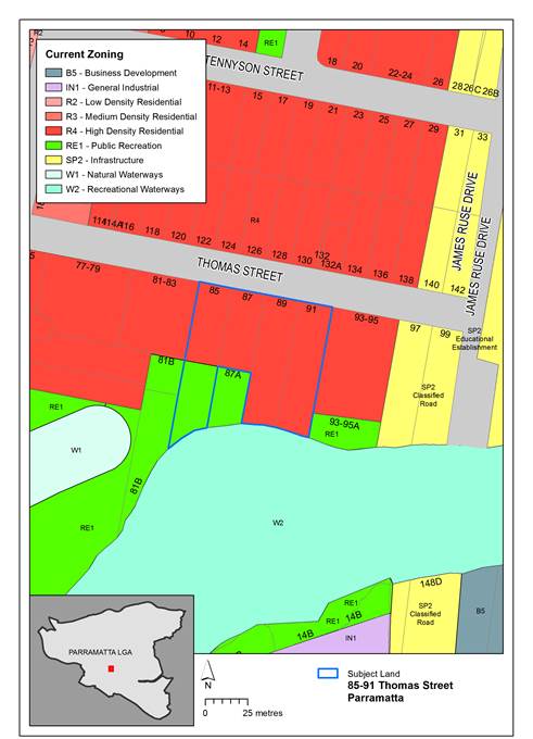
Figure 12 – Existing zoning extracted from Parramatta LEP 2011 Land Zoning Map
Figure 12 illustrates the existing R4 – High Density Residential, part RE1 Public Recreation
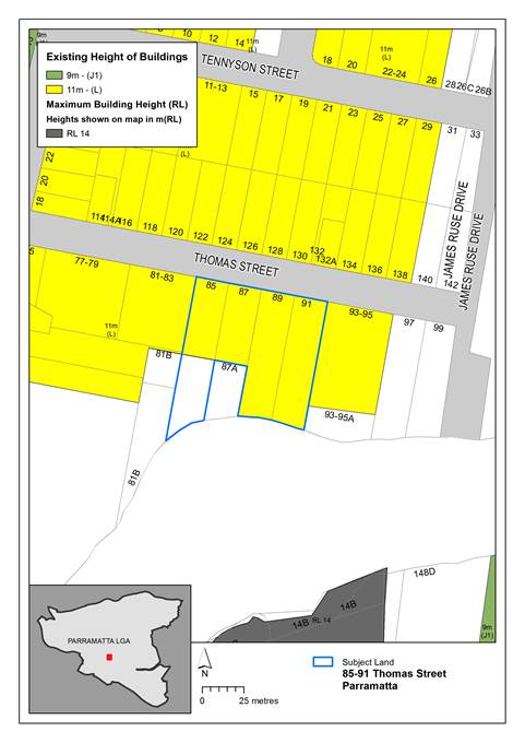
Figure 13 – Existing building heights extracted from the Parramatta LEP 2011 Height of Buildings Map
Figure 13 illustrates the existing 11 metre maximum building height.
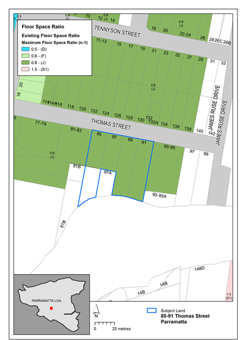
Figure 14 – Existing floor space ratio extracted from the Parramatta LEP 2011 Floor Space Ratio Map
Figure 14 illustrates the existing 0.8:1 Floor Space Ratio.
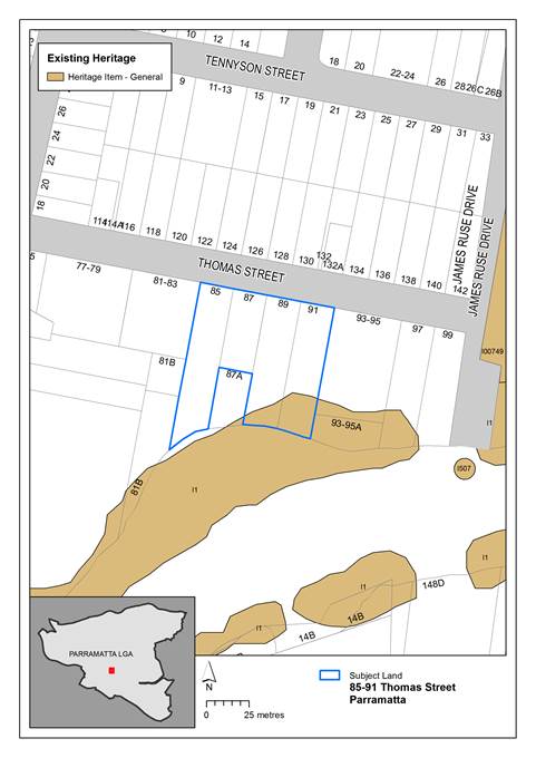
Figure 15 – Existing heritage items extracted from the Parramatta LEP 2011 Heritage Map
Figure 15 above illustrates Item 1 – Parramatta River Wetlands of local significance which impact the site.
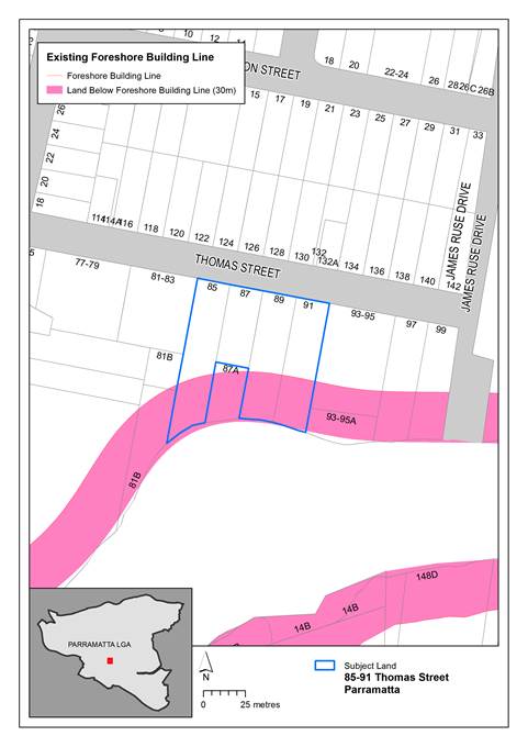
Figure 16 – Existing Foreshore Building Line in Parramatta LEP 2011 Map
Figure 16 above illustrates the extent of the Foreshore Building Line map
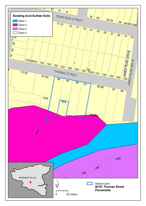
Figure 17 – Existing Acid Sulfate Soils in Parramatta LEP 2011 Map
Figure 17 above illustrates the extent of the Acid Sulfate Soils on the subject site. The developable portion is subject to Class 5, with some land to the south Class 2.
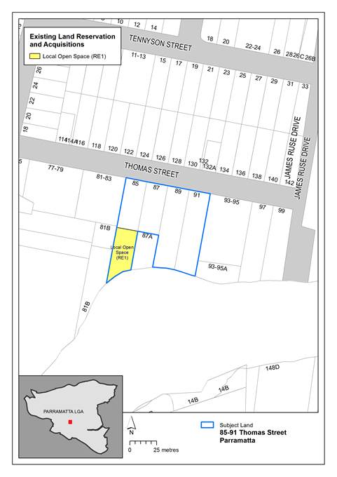
Figure 18 – Existing Land Reserved for Acquisition in Parramatta LEP 2011 Map
Figure 18 above illustrates the extent of the Land Reserved for Acquisition map showing the affectation on No.85 Thomas Street.
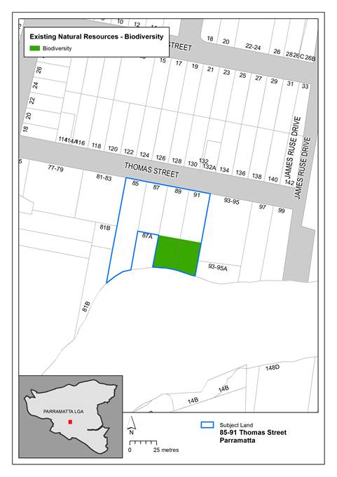
Figure 19 – Existing Natural Resources - Biodiversity in Parramatta LEP 2011 Map
Figure 19 above illustrates the extent of the Natural Resources -Biodiversity map showing the affectation on No.89-91 Thomas Street within the undevelopable portion of the site.
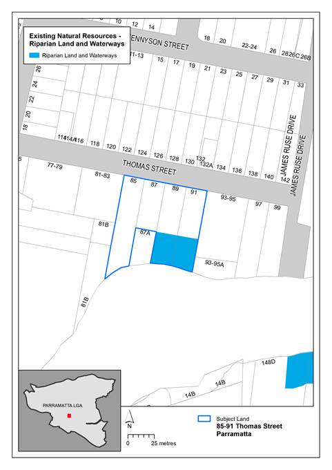
Figure 20 – Existing Natural Resources – Riparian Land and Waterways in Parramatta LEP 2011 Map
Figure 20 above illustrates the extent of the Natural Resources – Riparian Land and Waterways map showing the affectation on No.89-91 Thomas Street.

Figure 21 – Existing Minimum Lot Size in Parramatta LEP 2011 Map
Figure 21 above illustrates Minimum Lot Size of 550sqm on the subject site.
The figures in this section illustrate the proposed change to maximum building height for the subject site. No other changes are proposed as part of the Planning Proposal.
Figure 22 – Proposed amendment to the Parramatta LEP 2011 Land Use Zoning Map
Figure 22 above illustrates proposed boundary changes to land use zoning to reflect the developable portion of the site and proposed land dedication.
Figure 23 – Proposed Maximum Building Height in Parramatta LEP 2011 Map
Figure 23 above illustrates the extent of the proposed maximum building height up to 22 metres. It also shows the removal of HOB control for the undevelopable land.
Figure 24 – Proposed Floor Space Ratio in Parramatta LEP 2011 Map
Figure 24 above illustrates the extent of the proposed floor space ratio of 1.3:1. It also shows the removal of FSR control for the undevelopable land.
Figure 25: Proposed Minimum Lot Size Map in Parramatta LEP 2011 Map
Figure 25 illustrates the removal of the minimum lot size control from the undevelopable land proposed to be dedicated as part of the Planning Proposal.
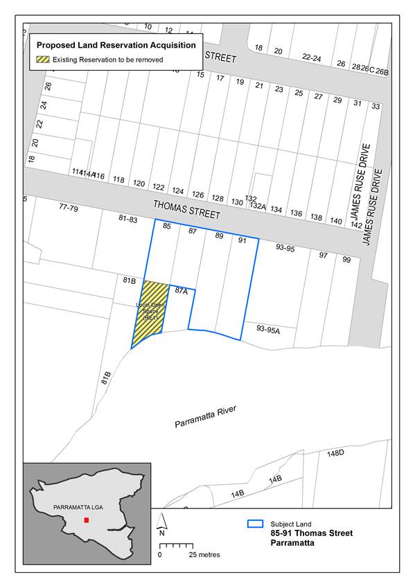
Figure 26: Proposed Land Reserved for Acquisition Map in Parramatta LEP 2011 Map
Figure 26 illustrates the extent of the proposed land reserved for acquisition map. It shows the removal of the land acquisition should the land be dedication for local open space.
PART 5 – COMMUNITY CONSULTATION
The planning proposal (as revised to comply with the Gateway determination) is to be publicly available for community consultation.
Public exhibition is likely to include:
· newspaper advertisement;
· display on the Council’s web-site; and
· written notification to adjoining landowners.
The gateway determination will specify the level of public consultation that must be undertaken in relation to the planning proposal including those with government agencies.
Consistent with sections 3.34(4) and 3.34(8) of the EP&A Act 1979, where community consultation is required, an instrument cannot be made unless the community has been given an opportunity to make submissions and the submissions have been considered.
Once the planning proposal has been referred to the Minister for review of the Gateway Determination and received a Gateway determination, the anticipated project timeline will be further refined, including at each major milestone throughout the planning proposal’s process.
Table 7 below outlines the anticipated timeframe for the completion of the planning proposal.
Table 7 – Anticipated timeframe to planning proposal process
|
MILESTONE |
ANTICIPATED TIMEFRAME |
|
Report to LPP on the assessment of the PP |
April 2020 |
|
Report to Council on the assessment of the PP |
May 2020 |
|
Referral to Minister for review of Gateway determination |
June 2020 |
|
Date of issue of the Gateway determination |
August 2020 |
|
Date of issue or revised Gateway determination (if relevant) |
|
|
Commencement and completion dates for public exhibition period |
November 2020 |
|
Commencement and completion dates for government agency notification |
December 2020 |
|
Consideration of submissions |
January 2021 |
|
Consideration of planning proposal post exhibition and associated report to Council |
March 2021 |
|
Submission to the Department to finalise the LEP |
April 2021 |
|
Notification of instrument |
May 2021 |
Appendix 1 – Concept Plans
(D07279676)
Appendix 2 – Ecological Response
(D06327650)
Appendix 3 – Traffic Report
(D06327650)
Appendix 4 – VPA Offer
(D07331699)
ITEM NUMBER 6.2
SUBJECT Planning Proposal - 8-14 Great Western Highway, Parramatta
REFERENCE RZ/6/2019 - D07250248
REPORT OF Student Project Officer
|
LANDOWNER JM Malouf Investments Pty Ltd and The Owners Strata Plan 8700 APPLICANT GLN Planning Pty Ltd
PURPOSE:
To seek the Local Planning Panel’s advice on a Planning Proposal seeking to amend Parramatta Local Environment Plan 2011 for land at 8-14 Great Western Highway, Parramatta by way of: · Increasing the height of building and floor space ratio controls; and · Inserting site-specific provisions relating to design excellence, high performing buildings, minimum commercial floor space, maximum additional commercial floor space and maximum car parking rates. for the purposes of requesting a Gateway Determination from the Department of Planning, Industry and Environment.
|
|
That the Local Planning Panel consider the following Council staff recommendation in the Panel’s advice to Council:
(a) That Council endorse the Planning Proposal at Attachment 1 for the purpose of requesting a Gateway Determination for land at 8-14 Great Western Highway, Parramatta, which seeks to amend Parramatta Local Environment Plan 2011 (PLEP 2011) by way of: i. Increasing the height of building control from 28 metres to 211 metres; ii. Amending the controls so that the FSR which is to apply to the site is composed of mapped components and bonuses as follows: a. Mapped FSR increased from 3.5:1 to 10:1 of which a minimum of 1:1 FSR must be commercial uses; b. Design Excellence bonus (15% - 1.5:1); c. High Performing Buildings bonus (5% - 0.5:1); d. Opportunity Sites bonus (3:1); e. Unlimited commercial FSR above the 1:1 requirement; and f. Insert a site-specific provision applying maximum car parking rates per the Parramatta CBD Strategic Transport Study.
(b) That the Planning Proposal be forwarded to the Department of Planning, Industry and Environment with a request for a Gateway Determination to be issued.
(c) That should a Gateway Determination be issued that structures the floor space ratio (FSR) and site specific clauses in an alternative way, that the Chief Executive Officer is authorised to make the necessary amendments to the Planning Proposal for the purposes of public exhibition, only where the total proposed FSR is unchanged.
(d) That should a Gateway Determination be issued, a site-specific Development Control Plan be prepared in accordance with the design principles contained within this report.
(e) That should a Gateway Determination be issued, the Chief Executive Officer be authorised to negotiate a Planning Agreement in accordance with Council’s Planning Agreements Policy.
(f) That the draft site-specific Development Control Plan and draft Planning Agreement be reported to Council for endorsement prior to being publicly exhibited concurrently with the Planning Proposal.
(g) That Council request the Department of Planning, Industry and Environment to issue Council’s Chief Executive Officer plan-making delegations for this Planning Proposal.
(h) Further, that Council authorise the Chief Executive Officer to correct any minor anomalies of a non-policy and administrative nature that may arise during the plan-making process.
|
PLANNING PROPOSAL TIMELINE
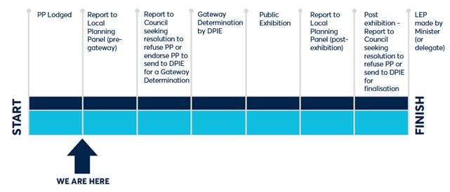
SITE DESCRIPTION
1. The subject site is located at 8 Great Western Highway (Lot 10 DP1097949) and 10-14 Great Western Highway, Parramatta (SP8700) and is approximately 2,386 sqm.
2. The site has a single frontage on the Great Western Highway at its southern boundary. The site is bound by three to eight storey residential flat buildings along its western and northern boundaries and a single-storey commercial building on its eastern boundary (refer Location Map at Figure 1). The site comprises a vacant lot and a three storey residential flat building above car parking (refer site condition photograph at Figure 2).
3. The subject site is located immediately adjacent to the site of 87 Church Street and 6 Great Western Highway (refer Figure 1) for which a Planning Proposal has been endorsed and is currently with the Department for finalisation.
4. The Planning Proposal initially lodged for the subject site was seeking to implement a height of building control of 147 metres (46 storeys) (166 metres (52 storeys) with design excellence), and a floor-space ratio control of 16.2:1 (including design excellence, high performing building, opportunity sites bonuses and additional commercial floor space bonuses). The assessment later in this report recommends the FSR as submitted but recommends Council apply a height of 211m (65 storeys).
Figure 1: An aerial image of the site and surrounds (subject site outlined in red, adjacent planning proposal at 87 Church Street & 6 Great Western Highway outlined in orange).
Figure 2: Existing subject site comprising of a 3 storey residential flat building above car parking.
CURRENT PLANNING CONTROLS
5. Under the Parramatta Local Environment Plan 2011, the site is subject to the following controls:
a. Land Use Zoning is B4 Mixed Use (refer Figure 3);
b. The maximum Height of Buildings is 28 metres (refer Figure 4);
c. The maximum Floor Space Ratio is 3.5:1 (refer Figure 5); and
d. The site is located within proximity of identified State Heritage Items (refer Figure 6).
6. The site is not flood prone.
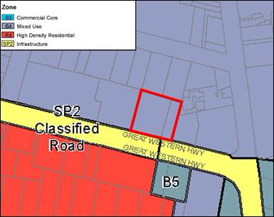
Figure 3: Current B4 Mixed Use Land Zoning applicable to the site under Parramatta LEP 2011.
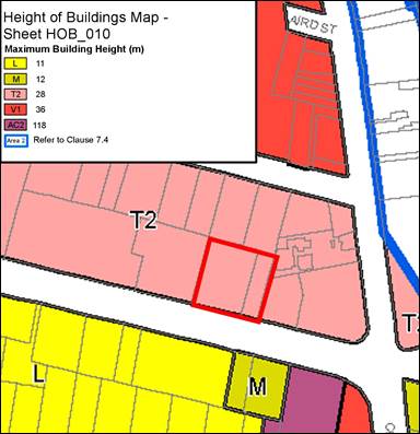
Figure 4: Current Height of Building of 28m applicable to the site under Parramatta LEP 2011.
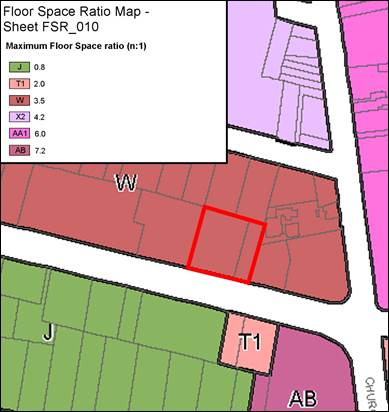
Figure 5: Current Floor Space Ratio of 3.5:1 applicable to the site under Parramatta LEP 2011.
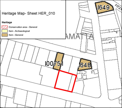
Figure 6: Identified heritage items within close proximity to the site under Parramatta LEP 2011.
3. The subject site is located in an archaeologically significant locality. It is categorised as possessing local archaeological significance and moderate archaeological research potential. The site is identified as Parramatta Archaeological Management Unit 3060 on the State Heritage Inventory. The site has potential structural and other archaeological remains associated with the occupation of these allotments since 1844. The site is also in the vicinity of Heritage Items 751 (Lennox House) and 648 (Masonic Centre), both of which are State heritage items.
PLANNING PROPOSAL SUMMARY
7. On 13 September 2019, a Planning Proposal (Attachment 1) was lodged with Council to amend the planning controls applicable to 8-14 Great Western Highway, Parramatta, under Parramatta Local Environment Plan 2011. Table 1 below summarises the planning controls sought by the applicant and provides a comparison between the current planning controls and the controls sought under the Parramatta CBD Planning Proposal.
Table 1: Site-specific Planning Proposal controls sought for the subject site
|
Site Area 2,386sqm |
Existing (Parramatta LEP 2011) |
Parramatta CBD Planning Proposal |
Site-specific Planning Proposal |
|
Zoning |
B4 Mixed Use |
B4 Mixed Use |
B4 Mixed Use |
|
Height of Buildings |
28m (8 storeys) |
211m (65 storeys) |
211m (exclusive of Design Excellence bonus – 65 storeys) - see further comments below |
|
Floor Space Ratio |
3.5:1 |
15:1 FSR (including the following). · 10:1 Mapped Incentive FSR (inclusive of 1:1 commercial FSR) · 1.5:1 Design Excellence FSR · 0.5:1 High Performing Building FSR · 3:1 Opportunity Site FSR · With the potential for unlimited additional commercial FSR*
|
15:1 FSR (including the following): · 10:1 Mapped Maximum FSR (inclusive of 1:1 commercial FSR) · 1.5:1 Design Excellence FSR · 0.5:1 High Performing Building FSR · 3:1 Opportunity Site FSR · Unlimited additional commercial floor space*
Total FSR of at least: 16.42:1 |
|
Parking |
Car Parking rates per Parramatta LEP 2011 |
Car parking rates as per Parramatta CBD Strategic Transport Study |
Car parking rates as per Parramatta CBD Strategic Transport Study |
*Above the required 1:1 minimum commercial provision but within the Height of Building control requirement
8. This site-specific Planning Proposal is seeking a total permitted floor-space ratio of 15:1, and a site-specific provision which allows for unlimited additional commercial gross-floor area, which is consistent with the proposed provisions of the Parramatta CBD Planning Proposal. A detailed assessment of its consistency with the intent of the Parramatta CBD Planning Proposal is provided below.
9. The planning controls seek to facilitate a mixed-use development with approximately 399 dwellings and at least 2,386 square metres of commercial gross floor area (GFA).
PLANNING PROPOSAL ASSESSMENT
Land Use Planning
Consistency with the Parramatta CBD Planning Proposal
10. The Parramatta CBD Planning Proposal received a Gateway Determination from the Department of Planning, Industry and Environment (DPIE) on 13 December 2018 and following satisfaction of several Gateway conditions, was endorsed by Council on 25 November 2019 for the purposes of consulting with State government agencies and the community. The Parramatta CBD Planning Proposal seeks to deliver a new planning framework for the Parramatta CBD, with the objective of realising Parramatta as Sydney’s ‘Central City’. This site-specific Planning Proposal is consistent with the controls proposed in the Parramatta CBD Planning Proposal and an assessment against these controls is provided below.
11. As indicated in Table 1 above, the proposed FSR which is to apply to this site is composed of five different components and are applied in the following order:
a. Mapped ‘incentive’ FSR (10:1) – a minimum of 1:1 FSR must be commercial uses;
b. Design Excellence bonus (15% - 1.5:1);
c. High Performing Buildings bonus (5% - 0.5:1);
d. Opportunity Sites bonus (3:1); and
e. Unlimited additional commercial FSR (applicant’s Urban Design Report indicates that at least 1.42:1 will be provided)
A Total FSR of at least 16.42:1
12. The FSR sought under the Planning Proposal has been structured in line with the Parramatta CBD Planning Proposal is described as follows.
13. Maximum mapped FSR: It is proposed to map a maximum FSR of 10:1 for the site which is consistent with the proposed ‘Incentive FSR’ in the CBD PP.
14. Minimum 1:1 commercial floorspace requirement: The endorsed Parramatta CBD Planning Proposal requires provision of a minimum of 1:1 FSR for commercial uses in specific parts of the CBD which are zoned B4 Mixed Use and which are generally in the vicinity of the B3 Commercial Core zone. This provision applies to this site, and the reference design satisfies this requirement, with commercial floorspace located on the ground floor and podium of the building.
15. Design excellence bonus: The design excellence provision will relate to Clause 7.10 of the current PLEP 2011 which provides for a 15 percent bonus for the mapped FSR (1.5:1 FSR) controls following a competitive design excellence process. The objective of design excellence is to deliver the highest standard of architectural, urban and landscape design. It is noted that the Parramatta CBD Planning Proposal proposes to retain the design excellence bonuses currently provided under Clause 7.10.
16. High performing buildings: The high performing buildings (HPB) provision is proposed under the Parramatta CBD Planning Proposal which is a 5% bonus (on the 10:1 FSR, therefore 0.5:1). This provision aims to manage the increased demand for power and water services within Parramatta CBD. To meet the criteria, a residential and mixed use development must have a mapped floor space ratio of 6:1 or more, a site area greater than 1,800sqm and front building line greater than 24m. Residential development over 41 storeys (reference design is 52 storeys) must achieve the following targets greater than current BASIX targets:
a. The energy target is a minimum 10-point increase in the BASIX score compared to current requirements.
b. The water target is a minimum 15-point increase in the BASIX score compared to current requirements.
A site-specific clause can ensure that the HPB requirements are met, and is recommended as part of a draft site-specific clause included in the Planning Proposal at Attachment 1.
17. Opportunity Sites: The Parramatta CBD Planning Proposal recognises the capacity for certain sites throughout the CBD to provide additional residential floor-space than what is provided under the ‘incentive’ FSR control. These ‘Opportunity Sites’ can provide for an additional 3:1 FSR (only once the design excellence and high performing building bonuses have been utilised).
18. The subject site is identified by the Parramatta CBD Planning Proposal on the proposed Opportunity Sites map and meets the criteria for achieving a 3:1 opportunity sites bonus. It is considered that the site conditions, Planning Proposal and reference design indicate that a development proposed on this site could be capable of meeting each of these criteria. A summary of the criteria which “unlocks” Opportunity Site FSR is:
a. The development site must be at least 40 metres wide at the front building line and have an area of at least 1,800 square metres;
b. The development must demonstrate an appropriate transition to any heritage items;
c. The development must achieve the Design Excellence bonus (through completion of a competitive design process);
d. The development must achieve the High Performing Buildings bonus (through meeting High Performing Building requirements); and
e. A site-specific DCP is to be prepared.
19. The Parramatta CBD Planning Proposal also requires that Opportunity Sites provide a community infrastructure contribution. However it is recognised that this mechanism is proposed as part of the Parramatta CBD Planning Framework. It is proposed that the comparable community infrastructure contribution / rate be applied as part of any Planning Agreement negotiated for the subject proposal.
20. Additional Commercial FSR: To support the growth of Parramatta as Sydney’s Central City, the Parramatta CBD Planning Proposal seeks to provide incentives for commercial development in the B4 Mixed Use zone. The Parramatta CBD Planning Proposal seeks to permit ‘unlimited’ commercial FSR, above the minimum 1:1, for sites with a land area greater than 1,800 square metres and located within the B4 Mixed Use zone. The applicant has identified that a commercial floor space of 1.42:1 (above the 1:1 minimum requirement) allows the building podium to be ‘filled-in’ with entirely commercial uses.
21. It is recommended that this site-specific Planning Proposal progress with a site-specific provision which allows for an unlimited additional commercial floor space above the 1:1 already mandated, rather than the 1.42:1 additional commercial FSR identified in the applicant’s Urban Design Report. This is to ensure consistency with the controls sought in the Parramatta CBD Planning Proposal.
Alternative structure of FSR ‘bonuses’
22. Like the subject Planning Proposal, two site specific planning proposals within the Parramatta CBD at 2 O’Connell Street and 12 Hassall Street have utilised the site specific FSR bonuses (including Opportunity Sites bonus).
23. At the time these proposals were being considered the DPIE had yet to issue Gateway Determination for the Parramatta CBD Planning Proposal. The reason for a different format being chosen for the two preceding Planning Proposals is because the DPIE advised that planning proposals must be formatted so as not to pre-empt the outcomes of the Parramatta CBD Planning Proposal gateway determination, and to be structured more like the PLEP 2011.
24. Now that the Parramatta CBD Planning Proposal is substantially more progressed at this time and has received Gateway Determination (on 13 December 2018) the site specific bonuses relating to FSR should be matched to the structure proposed in the Parramatta CBD Planning Proposal as much as possible. This will make the bonuses and the reason they are being applied more transparent and ensure they can be better be assessed on merit at development application stage.
25. However, in the event that DPIE does not agree with this approach, the Chief Executive Officer should be authorised to make any required amendments to the Planning Proposal for the purposes of public exhibition, as long as the overall approach to FSR bonuses is unchanged. Granting this delegation will ensure that if the Department requires a different structure for the Planning Proposal that this can be dealt with without the need for a further report to Council.
Height of Buildings
26. The Parramatta CBD Planning Proposal seeks a maximum building height of RL 211 metres, which reflects the maximum height limit permitted by the Civil Aviation Safety Authority.
27. In relation to the subject proposal, Council’s internal testing of the urban design analysis report indicated that a mixed-use development incorporating a floor-space ratio of 16.42:1 (as provided in the applicant’s Urban Design Report), with appropriate setbacks, would be accommodated on the subject site within a height of 170 metres (52 storeys), rather than the applicant’s proposed 166 metres (51 storeys). However, the Planning Proposal has been amended to request a height of RL 211 metres (65 storeys), (RL 243 metres (75 storeys) with Design Excellence).
28. This amendment to the Planning Proposal acknowledges the amendment to allow unlimited commercial floor-space above the 1:1 requirement, consistent with the Parramatta CBD Planning Proposal. Further to this, the proposed height of RL 211 metres is consistent with the Parramatta CBD Planning Proposal and allows for design flexibility. It may be necessary due to traffic and road widening issues discussed later in this report for a narrower and taller tower to ultimately be built on this site. Allowing for a height consistent with the Parramatta CBD Planning Proposal gives the flexibility to deal with these design issues that may require additional height above that shown in the current reference design. The impact of allowing a taller building has already been assessed and shown to be acceptable as part of the Parramatta CBD Planning Proposal process.
Urban Design
29. The Planning Proposal was lodged on 13 September 2019 with an urban design report and reference design completed by Plus Architecture that is provided at Attachment 2. The reference design incorporated Council’s urban design advice (both at pre-lodgement and lodgement stages) in relation to building envelope and setbacks.
30. The reference design provides a 6 metres setback from Great Western Highway to accommodate three large trees (2 blue gums and 1 spotted gum) located within this setback, and to facilitate additional deep-soil planting at development stage. The proposed front ground level setback of 6 metres is consistent with the winning design excellence scheme at 87 Church Street.
31. It is proposed to have a 0 metre ground level setback and 9 metre upper level setback to the west so should the neighbouring lot at 18-20 Great Western Highway be redeveloped, a consistent street wall should be created. Further, ground level and upper level setbacks proposed to the north and south are 6m and 3m respectively and are consistent with Council’s Urban Design team’s advice. Similarly the eastern boundary will have a ground level setback of 3 metres and 6 metres upper level setback. Proposed setbacks are shown at Figure 7 below.
32. Should the Planning Proposal receive a Gateway Determination from the Department, built form controls based on the reference design will be drafted including ground and upper level setbacks to be incorporated into a site-specific Development Control Plan and will be reported to Council for endorsement to be exhibited concurrently with the Planning Proposal.
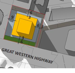
Figure 7: Proposed setbacks (Source: Applicant’s Urban Design Analysis, Plus Architecture 2019)
33. It is acknowledged that this Planning Proposal will result in additional overshadowing to its surrounds. As part of the Parramatta CBD Planning Proposal, Council undertook the Overshadowing in the Parramatta CBD - Technical Paper (November 2019) which provided a cumulative overshadowing analysis of the controls proposed under the Parramatta CBD Planning Proposal. The report undertook an analysis of the impact on key public spaces and open spaces, some heritage items and heritage conservation areas within and surrounding the CBD. Due to its location, the subject site does not impact on these key areas.
Traffic and Transport
Car parking rates
34. The maximum parking rates recommended by the Parramatta CBD Strategic Transport Study are to be adopted for the subject site within a site specific clause in the LEP. This is also supported by Transport for NSW in its pre-consultation in relation to this Planning Proposal.
Potential road widening
35. Council’s Transport Planning Team is currently working with Transport for NSW (TfNSW) to develop an Integrated Transport Plan, as part of the Parramatta CBD Planning Proposal. This may result in additional proposed road widening corridors throughout Parramatta CBD.
36. As the Great Western Highway is a major arterial road within the Parramatta CBD, Council Officers sought preliminary feedback from TfNSW to understand whether potential road widening corridor along Great Western Highway could occur in the future, as this could affect the built form on the subject site. TfNSW responded that without the recommendations of the Integrated Transport Plan, TfNSW were unable to confirm if the subject site would be impacted by any infrastructure improvements along the Great Western Highway in the future.
37. Council’s Urban Design Officers recommended a minimum 6 metres setback from the boundary to ensure the retention of the existing trees along the Great Western Highway frontage. The 6 metres setback will accommodate the trees but TfNSW and Council Traffic and Parking Team may require road widening and/or a deceleration lane which puts these trees at potential risk. As discussed in more detail below the draft DCP process will be used to determine the road widening and deceleration lane requirements and whether the trees can be retained. The appropriate setback will also be determined as part of this process.
Further consultation with TfNSW
38. Furthermore, TfNSW requested that Planning Proposal is not exhibited or finalised until such time that the Parramatta CBD Planning Proposal and the Integrated Transport Plan are both completed, so that the proposal can respond to the outcomes of these two key documents. However should the proposal be supported by Council to proceed through the Gateway process, TfNSW requests that consultation is carried out prior to public exhibition occurring.
39. Council Officers consider that there is an opportunity to include in a Planning Agreement and/or site-specific DCP requiring the applicant to provide the road widening at Development Application stage if it is required by TfNSW at that time. It is proposed that TfNSW will be consulted on the inclusion of this sort of mechanism in the Planning Agreement and/or site-specific DCP before any Planning Agreement and/or site-specific DCP is forwarded to Council for endorsement. This will ensure TfNSW are consulted again prior to exhibition of the Planning Proposal.
Vehicular access and servicing
40. TfNSW have also requested to be consulted on a site-specific draft DCP prior to exhibition and have made specific comments to include the following:
a) Relocation of the vehicle access point from the eastern boundary to the western boundary so that the access point is located as far away from the Great Western Highway and Church Street intersection as possible.
b) The access point is to be wide enough to allow for simultaneous entry and exit movements.
c) Parking for building maintenance, garbage collection and removalists is to be provided on site. These service vehicles are to be accommodated within the site and are not to impact the functioning of the Great Western Highway.
d) Identify service vehicle requirements to be supported by an assessment of the service vehicle access arrangements. Swept paths for the longest design vehicle to access the site are to be provided demonstrating that these vehicles can safely enter and exit the subject site in a forward direction while standard small rigid vehicles utilise the access point, as well as manoeuvre throughout the site.
41. Council’s Traffic Engineers advise that a deceleration lane from Great Western Highway onto the site may be required. The ‘trigger’ for the deceleration late would be dependent on traffic generation/traffic distribution figures within the applicant’s traffic report at development application stage. Council would also be required to liaise with TfNSW before making a decision as it is a classified road. If a lane is required, it is likely to need to be a standard 2.8-2.9m width and the length would be dependent on the findings of the traffic report.
42. There is a potential conflict between the deceleration lane issue raised by Council Officers and the request by TFNSW for the access to be moved to the western end of the site. If the access point is moved to the western end of the site any deceleration lane would be required to be located in front of the adjoining site to the west at 18-20 Great Western Highway. If it is retained as the eastern end it can be accommodated along the front of the subject site.
43. Delivery of a deceleration lane along the front of the site is more achievable because it can be incorporated into the redevelopment of the site and a land dedication can be made so that the footpath relocation required to accommodate the deceleration lane can be integrated into the redevelopment of the subject site.
44. If the deceleration lane is required along the front of the adjoining site at 18-20 Great Western Highway this would require some land acquisition as it would not be possible to accommodate a deceleration lane without acquiring some of 18-20 Great Western Highway to retain a safe footpath for pedestrians. The existing building on 18-20 has a setback of approximately 10m so acquisition is viable but measures would need to be put in place in the Parramatta LEP 2011 to allow for acquisition of the land or powers under the Roads Act 1993 would need to be utilised to ensure the land acquisition required to any deceleration lane is achievable.
45. The driveway location should be indicated in the site-specific DCP. It is considered that the Planning Proposal can proceed to Gateway while the access and deceleration issues are further investigated. This will allow Council to finalise its position on the driveway and deceleration lane locations in the site-specific DCP proposed to be prepared for this site. The site-specific DCP will be reported to Council for its consideration prior to any exhibition of this Planning Proposal.
46. There is also a risk that if a deceleration lane is required along the front of the subject site and an additional laneway is required that the setback of 6m shown in the reference design may need to be increased. This report recommends that the height of 211m and a clause allowing unlimited commercial floor space be applied as per the Parramatta CBD Planning Proposal. This means that the ultimate FSR achievable on this site will be determined by the applicant via the design excellence and development application processes and will probably be dependent on the commercial viability of providing additional office space above the 1:1. An increase in the front setback would decrease the maximum FSR theoretically achievable because it will have an impact on the size of the podium and potentially the tower floor plate. However, Officers are satisfied that an FSR of at least 16.42:1 could still be achieved as proposed by the applicant in their original application even with an increased front setback.
47. If an increased setback is required to accommodate the road widening and deceleration lane this can be factored into the site-specific DCP. The intention will be to ensure the DCP is flexible to give direction on the preferable development outcome that takes into account possible future road widening and deceleration lane requirements.
48. A site-specific DCP and Planning Agreement preparation process involving the applicant, TfNSW and Council Officers will ensure the access and road widening issues are addressed prior to the exhibition of these policy documents in conjunction with the Planning Proposal.
Heritage
49. As indicated in Figure 6, the subject site is within close proximity to two State heritage listed items, Lennox House at 39 Campbell Street, which is diagonally behind the subject site, and the Parramatta Masonic Centre at 47 Campbell Street (refer Figures 8 & 9).
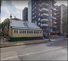
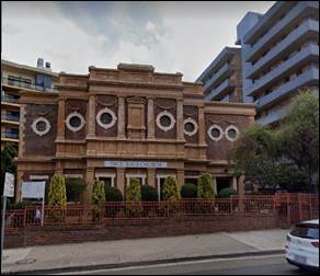
Figures 8 & 9: Lennox House and Parramatta Masonic Centre (Source GoogleMaps, 24 April 2020)
50. Council’s Heritage Advisor has reviewed the Planning Proposal and accompanying Urban Design Analysis report and provided the following recommendations which will can incorporated into a site-specific DCP and then assessed at both design excellence and/or development application stage:
a) A geotechnical report must be prepared, to establish if there will be any impact of works on the stability of grounds in the sites of the two heritage items (i.e. Lennox House and the Masonic Centre). This report must address stability during construction works and after construction.
b) An assessment of heritage impact must be prepared and submitted with any eventual development application, to ensure the buildings form, proportions, view lines, materials, colours and design are responding to the heritage items.
c) An evenly vertical elevation of any new development, which faces the two heritage items in order to minimise visibility in the background of the heritage items.
51. It is considered that the interface or transition to the heritage items which are diagonal to the north of the subject site can be addressed through assessment criteria established in the site-specific DCP.
52. As the site is located within Archaeological Management Unit 3060, which is identified as being of local significance with moderate archaeological research potential, it is recommended that the site-specific DCP includes a requirement that an archaeological assessment be required for any future development application.
SITE-SPECIFIC DEVELOPMENT CONTROL PLAN
53. Should a Gateway Determination be issued, a site-specific DCP will be prepared for the site. Principles to be addressed in the site-specific DCP are to include, but are not limited to, built form, building separation and setbacks, heritage interface, vehicle access points and deceleration lane requirements and landscaping.
54. Prior to public exhibition, the draft site-specific DCP will be reported to Council for endorsement prior to being publicly exhibited concurrently with the Planning Proposal and Planning Agreement.
PLAN-MAKING DELEGATIONS
55. New delegations were announced by the then Minister for Planning and Infrastructure in October 2012, allowing councils to make LEP amendments of local significance. On 26 November 2012, Council resolved to accept the delegation for plan-making functions and that these functions be delegated to the Chief Executive Officer.
56. Should Council resolve to proceed with the subject Planning Proposal, it is recommended that Council issue a request to the Department that it be able to exercise its plan-making delegations for the Planning Proposal. If the Department agrees to this request, this means that once the Planning Proposal has been to Gateway, undergone public exhibition and been adopted by Council, Council Officers will liaise directly with the Parliamentary Counsel Office on the legal drafting and mapping of the LEP amendment. The LEP amendment would then be signed by Council’s Chief Executive Officer before being notified on the NSW Legislation website.
FINANCIAL IMPLICATION FOR COUNCIL
Draft Planning Agreement
57. The applicant has indicated their willingness to enter into a Planning Agreement in accordance with Council policy and the endorsed Council rates as of April 2017. Should a Gateway Determination be issued, it is recommended that the Chief Executive Officer be authorised to negotiate a Planning Agreement in accordance with the Planning Agreements Policy, which references the Parramatta CBD Planning Proposal’s provisions regarding community infrastructure needs. The outcome of the draft Planning Agreement negotiation will be reported to Council for endorsement before the draft Planning Agreement is publicly exhibited.
58. The Parramatta CBD Planning framework includes a resolution of Council dated 10 April 2017 which applies a ‘Phase 1’ community infrastructure contribution and a ‘Phase 2’ community infrastructure contribution whichever Community Infrastructure rate applies to residential development at the time of negotiation. Based on the maximum development potential currently proposed under this Planning Proposal and Council’s endorsed community infrastructure rates the amount payable would be $5,010,600. However, when negotiating the Planning Agreement a clause will be sought that requires the applicant to pay the community infrastructure contribution rate at the time of payment. If this is agreed and the contribution rate is increased Council would be paid the higher amount applicable at that time.
CONCLUSION AND NEXT STEPS
59. The Planning Proposal is consistent with the Parramatta CBD Planning Proposal and has planning merit to progress to the next stage.
60. It is considered appropriate that this Planning Proposal be endorsed for the purposes of seeking a Gateway Determination. If the Parramatta Local Planning Panel supports the recommendations of this report, a further report will be prepared for Council to consider the Local Planning Panel’s advice. If Council resolves to proceed with the Planning Proposal, it will be forwarded to the Department of Planning, Industry and Environment requesting a Gateway Determination.
61. If a Gateway Determination is received, the Planning Proposal will be placed on public exhibition concurrently with the site-specific Development Control Plan and Planning Agreement. A report on the outcomes of the public exhibition will be provided to the Local Planning Panel addressing any objections received. If no objections are received, the matter will be reported directly to Council seeking approval to finalise the Planning Proposal.
Grace Haydon
Student Project Officer
Marko Rubcic
Project Officer, Land Use Planning
Bianca Lewis
Team Leader Land Use Planning
Robert Cologna
Land Use Planning Manager
David Birds
Group Manager, City Planning
Jennifer Concato
Executive Director City Strategy & Development
|
1⇩ |
Planning Proposal |
|
|
|
2⇩ |
Urban Design Report |
|
|
REFERENCE MATERIAL
ITEM NUMBER 6.3
SUBJECT Post-exhibition: Planning Proposal, draft site-specific Development Control Plan and draft Planning Agreement at 55 Aird Street, Parramatta
REFERENCE RZ/18/2015 - D07373232
REPORT OF Project Officer, Land Use Planning
|
Landowner 55 Aird Pty Ltd
applicant Think Planners Pty Ltd
PURPOSE: To report to the Local Planning Panel the outcome of the public exhibition for the Planning Proposal, draft site-specific Development Control Plan and draft Planning Agreement for land at 55 Aird Street, Parramatta. |
|
That the Local Planning Panel consider the following Council staff recommendation in the Panel’s advice to Council:
(a) That Council notes that one (1) submission was made during the public exhibition of the Planning Proposal, draft site-specific Development Control Plan and draft Planning Agreement at 55 Aird Street, Parramatta.
(b) That Council endorse the Planning Proposal for land at 55 Aird Street (provided at Attachment 1) subject to the Planning Proposal being amended to clarify the purpose of the minimum commercial floor-space provision is to encourage employment-generating uses in the case of a mixed-use development.
(c) That Council forward the Planning Proposal to the Department of Planning, Industry and Environment for finalisation and request that the final notification in the Government Gazette only be undertaken once Council confirms that the Planning Agreement has been executed.
(d) That Council endorse for finalisation the site-specific Development Control Plan contained at Attachment 2 for insertion in Section 4.3.3 – Parramatta City Centre of Parramatta Development Control Plan 2011.
(e) That Council enter into the Planning Agreement as exhibited at Attachment 3 and authorise the Chief Executive Officer to sign the Planning Agreement.
(f) Further, that Council authorise the Chief Executive Officer to make any minor amendments and corrections of a non-policy and administrative nature that may arise during the plan amendment process, relating to the Planning Proposal, Development Control Plan and Planning Agreement. |
PLANNING PROPOSAL TIMELINE
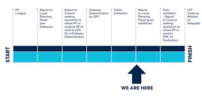
THE SITE
1. An aerial photo of the subject land at 55 Aird Street, Parramatta is shown in Figure 1. It has an area of 658 square metres and is adjoined by Westfield Shopping Centre to the west and south, and two-storey commercial buildings immediately to the east. Demolition of the building on the site was granted development consent (DA/1045/2017) and demolition has occurred. The site currently contains a concrete pad as the only remaining portion of the previous building.
![]()

Figure 1: The subject site outlined in yellow
BACKGROUND
2. In August 2015, a Planning Proposal was lodged for 55 Aird Street, Parramatta, which sought to increase the Height of Buildings control on the site from 36 metres (11 storeys) to 120 metres (38 storeys) and to increase the floor space ratio from 4.2:1 to 20:1. The applicant at the time proposed to develop the site as a mixed-use building.
3. At its meeting on 9 May 2016, Council resolved to endorse the planning proposal with a floor space ratio of 10:1 and no height limit, subject to Federal Government airspace provisions. The Planning Proposal was subsequently forwarded to the then Department of Planning and Environment (Department) for a Gateway Determination.
4. A Gateway Determination was issued by the Department in November 2017 which notably conditioned that the floor space ratio sliding-scale under Clause 7.2 of the Parramatta Local Environmental Plan 2011 be applied. This means that the effective floor space ratio for the site is 6:1, or 6.9:1 with the Design Excellence bonus.
5. In February 2018, the Department received a post-Gateway review request from the then applicant (Pacific Planning Pty Ltd) that objected to the floor space ratio sliding-scale provisions being applied to the subject site and certain other conditions of the Gateway Determination.
6. In October 2018 the Independent Planning Commission issued its recommendations which upheld the Gateway Determination in its entirety. An extension to the Gateway Determination was granted in January 2019 following the outcome of the Gateway review.
7. At its meeting on 25 February 2019, Council resolved to support the recommendations of the Independent Planning Commission made at the post-Gateway review, and agreed to proceed with the Planning Proposal as the Planning Proposal Authority.
8. In May 2019, Council Officers were approached by a new applicant and a new landowner who had purchased the site. They sought to progress the Planning Proposal in accordance with Council’s resolution of 25 February 2019, which required the preparation of a site-specific Development Control Plan (DCP) and a Planning Agreement which were to be exhibited concurrently with the Planning Proposal. The new landowner is seeking to develop the site as a hotel.
9. A second extension to the Gateway Determination was issued in January 2020 to allow Council to continue progressing the Planning Proposal and associated material with the new landowner.
10. At its meeting on 10 February 2020, Council endorsed the site-specific DCP and draft Planning Agreement to be exhibited concurrently with the Planning Proposal.
PLANNING PROPOSAL SUMMARY
11. The Planning Proposal (Attachment 1) seeks to amend Parramatta Local Environmental Plan 2011 (Parramatta LEP 2011) in the following way:
a) Amend the Height of Buildings Map from 36 metres to 80 metres (refer to Figure 8 of Attachment 1 Planning Proposal).
b) Amend the Floor Space Ratio Map (Sheet FSR_010) from 4.2:1 to 10:1 (refer to Figure 9 of Attachment 1 Planning Proposal).
c) Apply a site specific provision so that a minimum commercial floor space provision of 1:1 applies to the site (to be included as part of the 10:1 FSR).
d) Amend clause 7.14 to apply maximum car parking rates to the subject site.
12. Clause 7.2 of Parramatta LEP 2011 will continue to apply to the site. As such, the floor-space ratio sliding scale will reduce the effective floor-space ratio to 6:1 on the site. It is also noted that Design Excellence provisions under Clause 7.10 of the Parramatta LEP 2011 may allow for a 15% floor-space ratio bonus. Thus, the maximum floor-space ratio achievable on the site, if developed in isolation, is 6.9:1.
13. Table 1 below compares the controls proposed in the Planning Proposal to the current Parramatta LEP and the Parramatta CBD Planning Proposal controls. The Planning Proposal is consistent with the objectives and key built form (height and FSR) controls contained in the Parramatta CBD Planning Proposal.
Table 1: Summary of Proposal against current controls and proposed controls
|
|
Current Parramatta LEP 2011 |
Parramatta CBD Planning Proposal |
Subject Planning Proposal |
|
Site Area |
658m2 |
||
|
Land Use Zoning |
B4 Mixed Use |
B4 Mixed Use |
B4 Mixed Use |
|
Height of Buildings |
36m (11 storeys) |
RL 211m (62 storeys) |
80m (25 storeys) |
|
Floor-space ratio |
4.2:1 |
10:1 (6:1 if the FSR sliding-scale is applied) |
10:1 (6:1 following application of the FSR sliding-scale and 6.9:1 including Design Excellence bonus) |
|
Parking |
In accordance with Clause 7.3 |
Strategic Transport Study rates |
Strategic Transport Study rates |
|
Number of dwellings ^ |
32 dwellings |
46 dwellings |
46 dwellings or 155 hotel rooms * |
^ The number of dwellings has been estimated based on the maximum achievable residential gross-floor area (excluding bonuses) divided by an average apartment size of 85m2
* The draft DCP and amended reference design provided by the applicant reflects the proposal by the applicant to develop the site for a hotel
14. The Planning Proposal was granted a Gateway Determination prior to the Parramatta CBD Planning Proposal being endorsed by Council, meaning that the High Performing Building Bonus was never included in the Planning Proposal. However, in order to achieve the High Performing Building bonus, sites must be larger than 1,800 square metres, meaning that if developed on its own, this site would not qualify for the High Performing Buildings even when the Parramatta CBD Planning Proposal is finalised.
DEVELOPMENT CONTROL PLAN
15. A draft site-specific DCP was prepared by the applicant with input from Council Officers. Whilst the new landowner seeks to redevelop the site as a hotel, residential development is also permissible within the B4 Mixed-Use Zone. The site-specific DCP provides development parameters for the two different development scenarios being a hotel development or a mixed-use development (Attachment 2).
PLANNING AGREEMENT
16. Council’s resolution of 10 February 2020 included the authority to negotiate and draft a Planning Agreement in accordance with Council’s Planning Agreements Policy.
17. The applicant indicated that the site would be developed for non-residential purposes, meaning that the community infrastructure provisions of the draft Parramatta CBD Planning Proposal, which do not apply to the increase of commercial floor space, would not apply to the proposed development.
18. However, Council's practice is to require a Planning Agreement for any Planning Proposal in the B4 Mixed Use Zone, as any future use could include residential development. As such, a Planning Agreement is still required to be entered into, albeit with a condition that the contribution will only be delivered in the case where the site is developed incorporating residential development. No contribution would be required if the applicant proceeded to develop the site as a hotel.
19. The applicant has agreed to enter into a Planning Agreement on these terms and the draft Planning Agreement provides for a monetary contribution of $177,660 only in the case that the redevelopment contains residential uses. The draft Planning Agreement is provided at Attachment 3. Further, acknowledging that Council is undertaking a review of the community infrastructure rates, the Planning Agreement has been drafted in a manner so that the monetary contribution amount can be amended, should Council adopt different community infrastructure rates as part of the Parramatta CBD Community Infrastructure framework so the contribution made is consistent with Council’s Policy at the time the payment is made.
PUBLIC EXHIBITION
20. The subject Planning Proposal, draft site-specific Development Control Plan and draft Planning Agreement for 55 Aird Street were publicly exhibited from 4 March 2020 to 3 April 2020. The public exhibition included:
· An advertisement in the Parramatta Advertiser (date 4 March 2020)
· Letters to neighbouring landowners notify them of the pubic exhibition
· Letter to Transport for NSW notifying them of the public exhibition
· All relevant material placed on the City’s website
· Hard copies were located at the City’s Administration Building and Parramatta Central Library.
21. The exhibition material consisted of a copy of the Planning Proposal, draft site-specific Development Control Plan, draft Planning Agreement and supporting appendices including:
· The November 2017 Gateway Determination and January 2019 and January 2020 amended Gateway Determinations;
· Urban Design Report;
· Planning Agreement Explanatory Note; and
· Previous Council Officer assessment reports to Council.
22. It is noted that as a result of the COVID-19 pandemic and directives from the Federal Government and local health authorities, Council Libraries and the Customer Contact Centre were closed to the public on 23 March and 24 March respectively, meaning that it was not possible to view hard-copy exhibition material at libraries during this portion of the exhibition.
23. Subsequently on the 25 March 2020, the COVID-19 Legislation Amendment (Emergency Measures) Act 2020 removed the requirement for hard copies of exhibition material to be made during public exhibitions. It is noted that Council Officers did not receive any telephone calls from the public requesting access to hard copy material.
24. One (1) submission was received during the public exhibition. The submission was made by Transport for NSW which did not have any in-principle objection to the Planning Proposal, but made several recommendations to Council. A summary of the submission made by Transport for NSW and the Council Officer’s response to the recommendations can be found at Table 2 below.
Table 2: Summary and response to Transport for NSW submission
|
Transport for NSW submission |
Council Officer response |
|
Transport for NSW supports the inclusion of maximum car parking rates per the Parramatta CBD Strategic Transport Study. |
Noted. |
|
Transport for NSW has no objection to the future vehicle access point (via the Right of Way) as the site is accessed via local roads and access to the adjoining sites will continue to be provided via the Right of Way to Aird Street. It is suggested that the Right of Way arrangement is made clearer in the DCP to highlight this. |
Noted. The site-specific DCP has been amended so that the existing right of way that runs along the eastern edge of the site is clearly labelled and identifies all the sites that benefit from the easement. |
|
An appropriate funding mechanism/ agreement should be in place prior to the finalisation of any amendment to the LEP for the precinct. This will help ensure that developer contributions are obtained on a transparent and equitable basis for the provision of state and regional transport infrastructure required to support development uplift and future growth in the Parramatta CBD precinct and LGA. |
The contribution required for State and regional infrastructure is a reference to a proposed Special Infrastructure Contribution (SIC) which has been discussed by State Agencies but is yet to come into force. Council Officers are not satisfied that requiring an additional contribution from this site is a defendable position due to the inconsistency in the way this and other sites with similar applications are being treated. Several Gateway Determinations for site specific Planning Proposals within the Parramatta CBD have been issued without the requirement for a contribution for State infrastructure. Further the applicant has already agreed to enter into a Planning Agreement which provides a contribution towards public domain improvements in the Parramatta CBD if the site is developed for residential purposes. It is therefore recommended that the LEP amendment progresses, and that the matter be reported to the Department of Planning, Industry and Environment as a request from a Government Agency that Council has not satisfied. |
MINIMUM COMMERCIAL FLOOR SPACE PROVISION CLARIFICATION
25. An issue that needs to be clarified has arisen following a submission by the applicant of a design competition brief for this site. The Parramatta CBD Planning Proposal includes a policy that requires minimum commercial floor space of 1:1 to be provided on B4 Mixed Use sites. The objective of this policy position is to encourage further employment-generating uses surrounding the commercial core and to ensure that mixed-use developments still make a contribution towards job targets even where they are primarily being developed for residential purposes.
26. When this Planning Proposal was first lodged, the proposal was for a mixed use development. A clause was included in the Planning Proposal to require a minimum of 1:1 commercial floor space be provided consistent with the draft Parramatta CBD Planning Proposal. The new applicant is now proposing a hotel. The planning system has a separate legal definition that differentiates a hotel use from other generic commercial uses. If the Planning Proposal is finalised with a requirement to provide a minimum commercial floor space of 1:1, the hotel would not be recognised as commercial floor space and technically the 1:1 commercial floor space requirement would not be met. It would force the applicant to provide commercial floor space separate to the hotel use. Effectively it would decrease the size of the hotel and force the applicant to provide alternate commercial floor space.
27. The outcome discussed above under which a new hotel proposal must also provide 1:1 commercial floor space was not the intention of the policy framework proposed for the CBD. The hotel itself is generally recognised as an employment generating use. To ensure this does not become a problem during the assessment of any future development application, the Planning Proposal should include clarification that the 1:1 commercial floor space requirement will only be applied where a mixed use development is proposed.
FINANCIAL IMPLICATION FOR COUNCIL
28. A monetary contribution of $177,660 will be provided to Council only in the case that the redevelopment contains residential uses via a Planning Agreement. This calculation is consistent with Council’s current CBD Planning Proposal Community Infrastructure Framework which in this case would require a payment of $150 per square metre. However, the Planning Agreement has been drafted in a manner so that the monetary contribution amount can be amended should Council adopt different community infrastructure rates as part of the Parramatta CBD Community Infrastructure framework.
RECOMMENDENDED ACTIONS
29. The Planning Proposal is consistent with the objectives of the Parramatta CBD Planning Proposal and has undergone the required public consultation as conditioned in the Gateway Determination. The matters raised by the Transport for NSW submission have been addressed and it is recommended the Planning Proposal be forwarded to the Department of Planning, Industry and Environment for finalisation, subject to an amendment being made which clarifies that the purpose of the minimum commercial floor-space provision is to encourage employment-generating uses where a mixed-use development is proposed.
30. It is also recommended that Council adopt the associated site-specific Development Control Plan, with the amendment showing the right of way, and Planning Agreement and advise the Department that the final notification of the LEP amendment only be undertaken once Council confirms that the Planning Agreement has been executed.
31. Following Local Planning Panel consideration of the recommendations of this report, the outcomes of the exhibition period for this Planning Proposal will be reported to Council at an upcoming Council meeting along with the Panel’s advice.
Marko Rubcic
Project Officer, Land Use Planning
David Birds
Group Manager, City Planning
Jennifer Concato
Executive Director City Strategy & Development
|
1⇩ |
Planning Proposal |
|
|
|
2⇩ |
Draft site-specific Development Control Plan |
|
|
|
3⇩ |
Draft Planning Agreement |
|
|
REFERENCE MATERIAL
|
Draft site-specific Development Control Plan |
|
4.3.3 Parramatta City Centre |
|
4.3.3.7 City Centre Special Areas Update Figure 4.3.3.7.1. City Centre Special Areas on page 254 to include the subject site being: 55 Aird Street, Parramatta refer to Section 4.3.3.7 as shown outlined and shaded in black in Figure 4.3.3.7.1 City Centre Special Areas. |
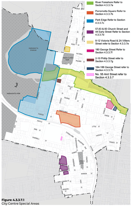
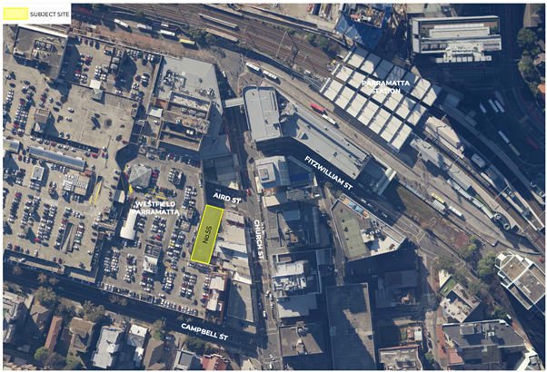
Figure 4.3.3.7.1 City Centre Special Areas
|
Insert new section 4.3.3.7 (i) being site specific controls relating to 55 Aird Street, Parramatta. |
|
4.3.3.7 (i) 55 Aird Street, Parramatta Land to which this applies This part of the Development Control Plan (DCP) applies to land at 55 Aird Street, Parramatta legally known as Lot 4 in DP310151 within the Parramatta CBD as illustrated in the extract below. Relationship to other Planning Documents or Sections within DCP 2011
This Part is to be read in conjunction with other parts of this DCP and the Parramatta LEP 2011. If there is any inconsistency between this part of the DCP and other parts of the Parramatta DCP 2011, this part of the DCP will prevail. This DCP establishes objectives and controls to be interpreted during preparation and assessment of development applications and supports the objectives of the LEP.
|
Guiding Principles
P.01 Facilitate redevelopment of the site as a high quality mixed use development to support the role of the Parramatta CBD.
P.02 Contribute to the public domain at ground level through an activated edge to Aird Street.
P.03 Design the street wall to create streets that are legible, comfortable, safe, functional and attractive.
P.04 Design the street wall to respond to existing built context.
P.05 Set back buildings above the street walls to allow daylight penetration, mitigate wind impacts and enable views to the sky in streets and public places.
P.06 Design the tower to be elegantly proportioned and maximise its slenderness of form.
P.07 Protect amenity, daylight penetration, views to the sky and privacy between adjoining developments and minimise the negative impacts of buildings on the amenity of the public domain.
P.08 Design and select the materials of buildings and the public domain to contribute to a high quality, durable and sustainable urban environment.
Building Envelopes
Objectives
O.01 Reinforce the spatial definition of the streets.
O.02 Design the street walls with an appropriate human scale and sense of enclosure for the streets.
O.03 Protect daylight access at street level and permit views of sky from the streets by providing setbacks above street frontage height that promote separation between buildings.
O.04 Ensure that building form achieves comfortable public domain conditions for pedestrians, with adequate daylight, appropriate scale, and mitigation of wind effects of the tower building.
O.05 Ensure that the ground level interface provides shelter for pedestrians in the form of an awning.
O.06 Ensure that built form achieves contextual fit with adjacent buildings on Aird and Church Streets.
Controls
C.01 Building envelopes must be consistent with the minimum setbacks specified in Figure 1 if a Hotel Development or Figure 2 if a Residential Development.
C.02 The street wall must be built to the street boundary along its full frontage on Aird Street.
C.03 Above the street wall the recessed tower element must be set back a minimum of 3m from Aird St.
C.04 Setbacks must be measured perpendicular to the boundary to the outer faces of the buildings.
C.05 The height of the podium at Aird must relate to the existing adjacent building to the west and south.
C.06 Any blank walls are to be designed or treated to provide a high quality finish of visual interest.
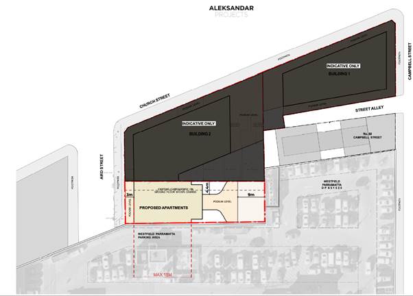
Figure 1 Hotel Scheme Building Envelope
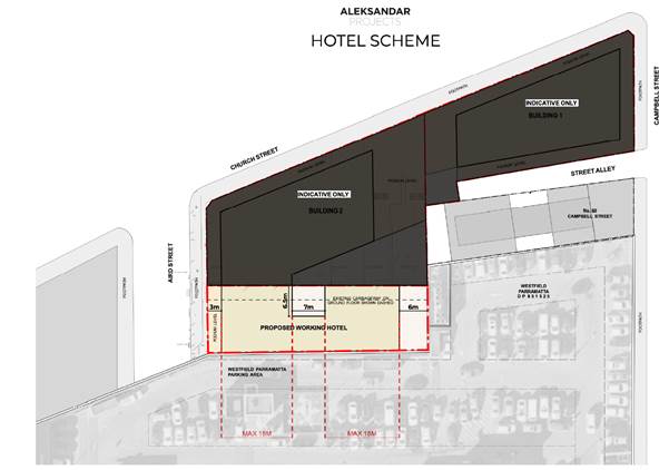
Figure 2 Residential Scheme Building Envelope
Note: This site is burdened with a Right of Way along its eastern boundary which benefits sites at 129, 131, 135, 137 and 141 Church Street, Parramatta. Nothing within this DCP seeks to amend the legal responsibilities of this easement.
Street Wall Design
Objectives
O.07 Define the space of the streets and articulate their edges.
O.08 Design the street walls to provide appropriate scale and detail.
O.09 Design the street walls to achieve fine grain modulation in the street.
O.10 Provide comfort and shelter for pedestrians.
O.11 Minimise large expanses of inactive frontage.
Controls
C.01 The podium street wall must:
o be modulated in vertical increments that relate to a fine grain subdivision pattern.
o be of masonry character with no lightweight panel construction.
o be articulated with depth, relief and shadow on the street façade. A minimum relief of 150mm between the masonry finish and glazing face must be achieved.
o utilize legible architectural elements and types - doors, windows, loggias, reveals, pilasters, cills, plinths, frame and infill, etc. - not necessarily expressed in a literal traditional manner.
o include semi-recessed awnings for pedestrian shelter.
o include a ground floor façade design which intensifies the walking experience with particular richness in detail.
C.02 Undercrofts or disruptions of the street wall which expose the underside of the tower and amplify its presence on the street are not permitted.
The Ground Floor
Objectives
1. Provide for the amenity, interest and liveliness of the pedestrian street environment.
2. Ensure a positive experience for pedestrians with the necessary fine grain environment of the street.
3. Integrate an engaging street interface with the design of the public domain, taking account of the topography of the site.
4. Optimise the extent of active frontages in the public domain.
5. Ensure appropriate scale and proportion of foyers and lobbies in relation to site frontage.
6. Promote activity, connectivity and variety in the public domain.
7. Contribute to the economic vitality of the city.
8. Ensure security measures do not inhibit passive surveillance on the street.
Controls
C.01 The ground floor frontage should have active uses.
C.02 Semi-recessed awnings must be provided.
C.03 Columns should not be located within the awning zone outside of the glazed frontage.
C.04 Glass awnings are not permitted.
C.05 The ground floor frontage must be designed in detail and the following must be incorporated in its design:
o The ground floor levels and façade structure and rhythm must be designed to present a fine grain street frontage.
o A nominal 500mm interface zone at the frontage should be set aside to create interest and variety in the streetscape, to be used for setbacks for entries, opening of windows, seating ledges, benches, and general articulation.
o The frontage must have a high level of expressed detail and tactile material quality.
o Facades must be vertically articulated.
o The modulation and articulation of the facade should include a well resolved meeting with the ground plane that also takes account of the slope. A horizontal plinth, integrated in the design, must be incorporated at the base of glazing to the footpath.
o The frontage must take account of the need to provide a clear path of travel for disabled access.
o Legible entrances must be formed in the frontage.
o Fire escapes and services must be seamlessly incorporated into the frontage with quality materials.
C.07 Security doors or grilles must be designed to be:
o Fitted internally behind a shopfront;
o Fully retractable; and
o A minimum 50% transparent when closed.
C.08 The frontage must provide for safety of the public and building occupants and not comprise of any unsafe deep recesses, such as entry lobbies.