|
Item 5.1 - Attachment 1 |
Attachment 1: Assessment Report |
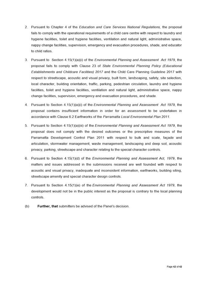
NOTICE OF Local Planning Panel MEETING
PUBLIC AGENDA
An Ordinary Local Planning Panel will be held remotely via audio-visual link, 21 April 2020 at 3.30pm.
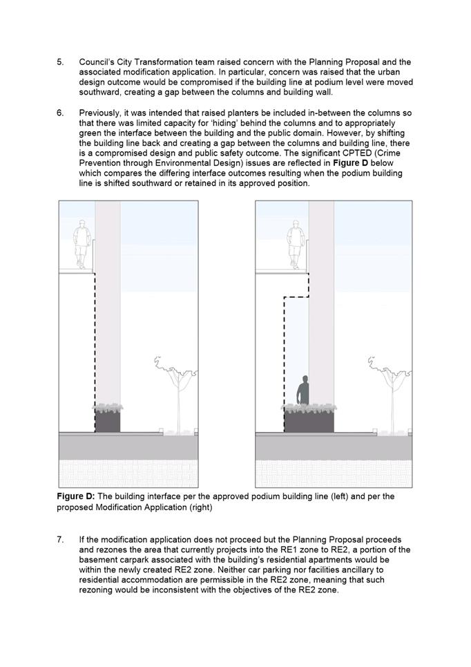
Brett Newman
CHIEF EXECUTIVE OFFICER
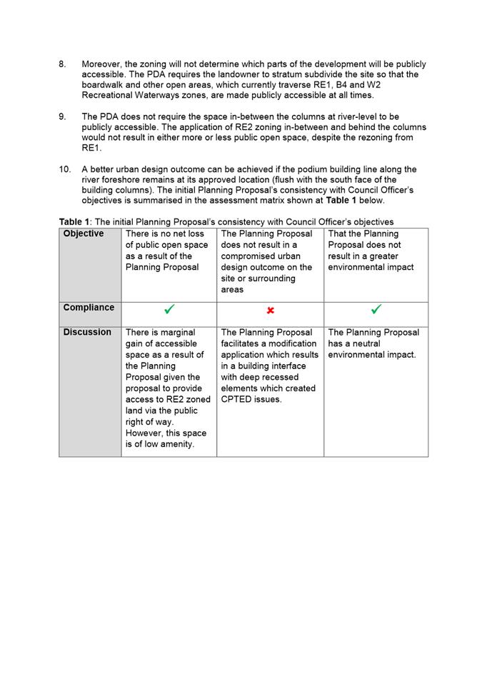
THIS PAGE LEFT BLANK INTENTIONALLY
Local Planning Panel 21 April 2020
TABLE OF CONTENTS
ITEM SUBJECT PAGE NO
1 ACKNOWLEDGMENT OF THE TRADITIONAL LAND OWNERS
The City of Parramatta Council acknowledges the Burramattagal Clan of The Darug, the traditional land owners of Parramatta and pays its respects to the elders both past and present
2 WEBCASTING ANNOUNCEMENT
This public meeting will be recorded. The recording will be archived and available on Council’s website.
All care is taken to maintain your privacy; however if you are in attendance in the public gallery, you should be aware that your presence may be recorded.
3 APOLOGIES
4 DECLARATIONS OF INTEREST
5 Reports - Development Applications
5.1 25 Lanhams Road, WINSTON HILLS................................................... 6
5.2 2-8
River Road West, Parramatta
(Lot 1 in DP 1204213 & CP in SP 94898) (Rosehill Ward)........... 188
5.3 26 Iona Avenue, North Rocks............................................................ 219
6 Innovative
6.1 Planning Proposal at 12-14 Phillip Street and 331A, 333 & 339 Church Street, Parramatta................................................................................ 252
6.2 Post Exhibition Outcome - Planning Proposal, draft site-specific Development Control Plan and draft Planning Agreement for 2 O'Connell Street, Parramatta................................................................................ 323
Development Applications
21 April 2020
5.1 25 Lanhams Road, WINSTON HILLS............................................................ 6
5.2 2-8
River Road West, Parramatta
(Lot 1 in DP 1204213 & CP in SP 94898) (Rosehill Ward)..................... 188
5.3 26 Iona Avenue, North Rocks...................................................................... 219
Local Planning Panel 21 April 2020 Item 5.1
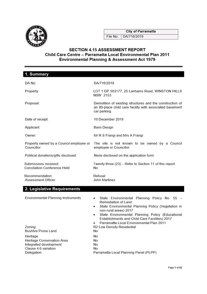
ITEM NUMBER 5.1
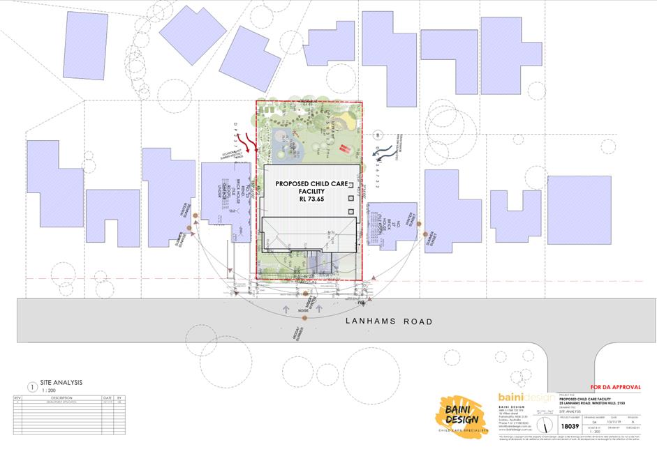
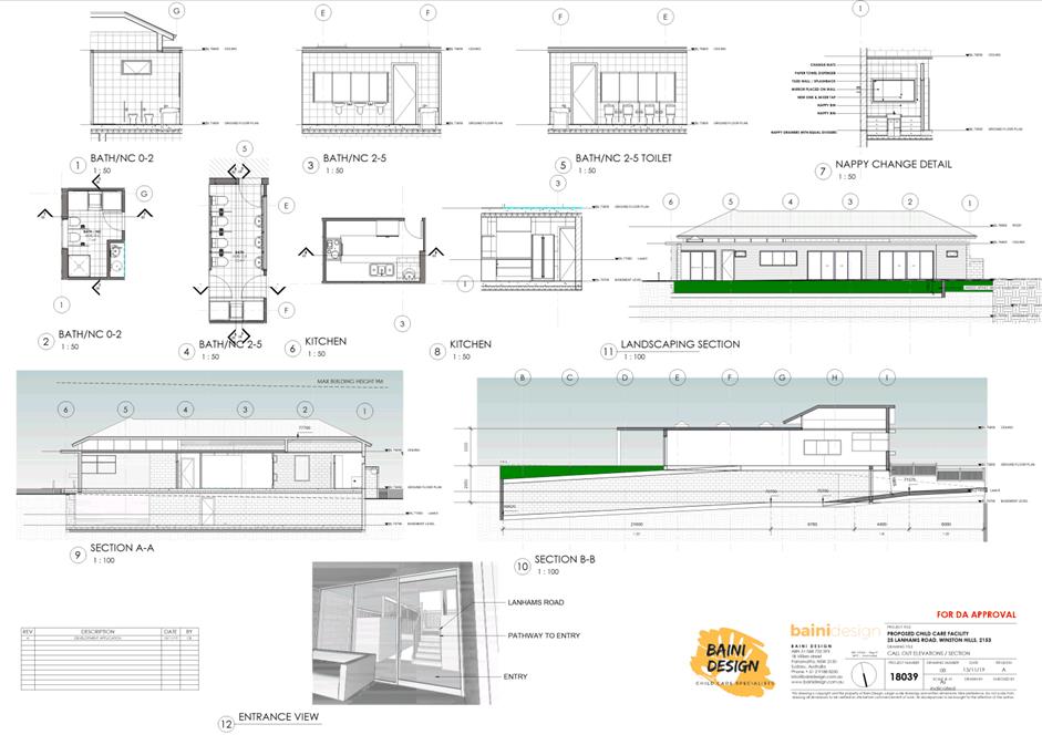
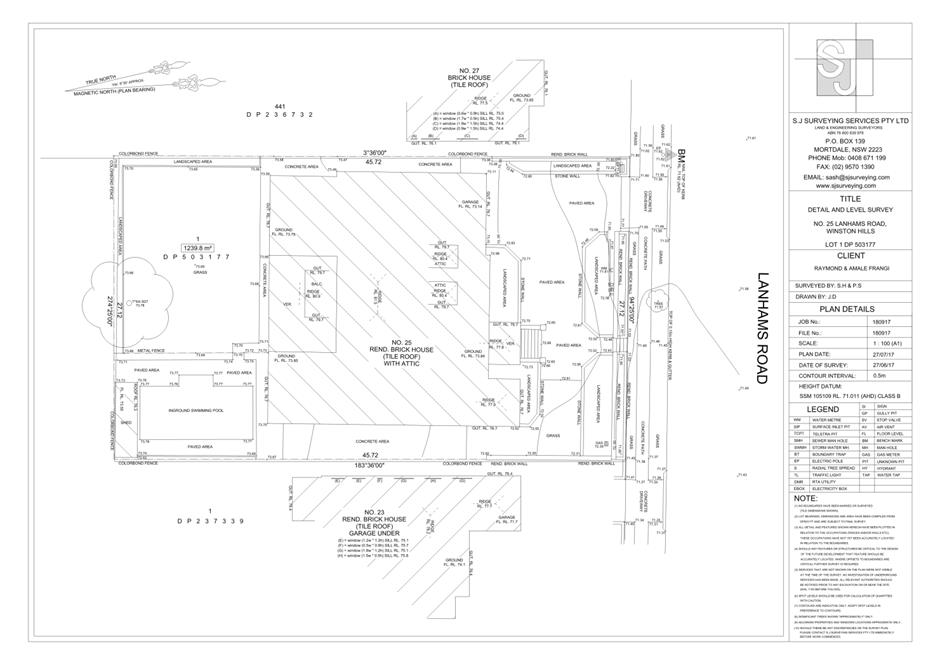
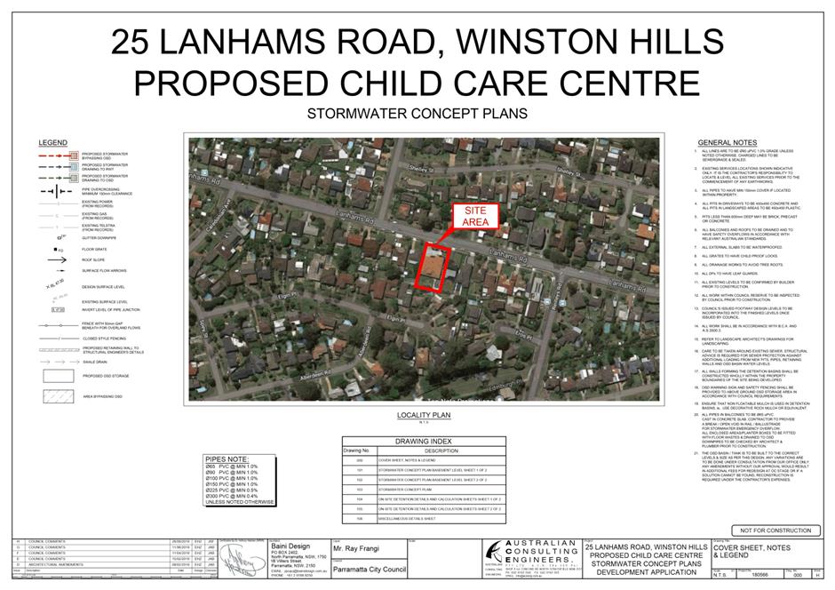
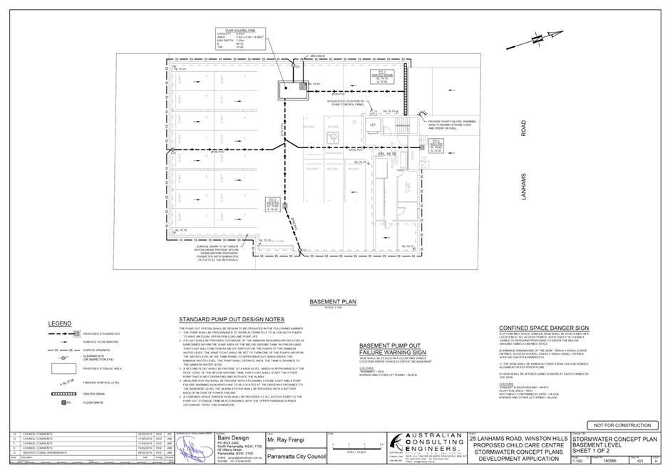
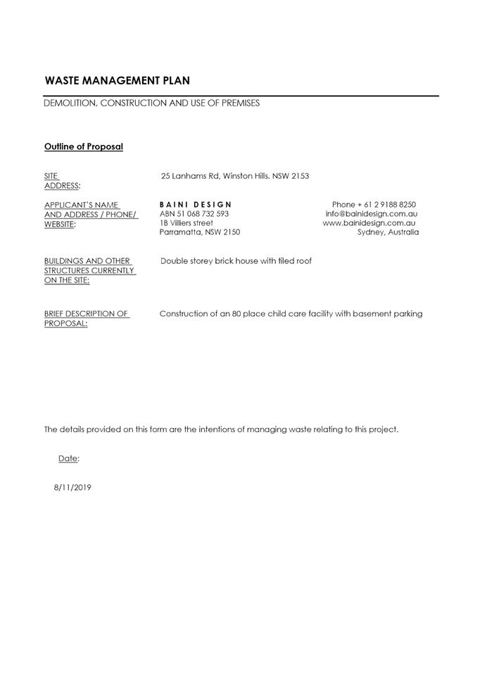
SUBJECT 25 Lanhams Road, WINSTON HILLS
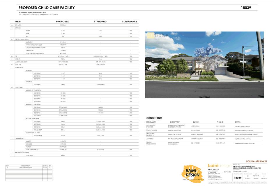
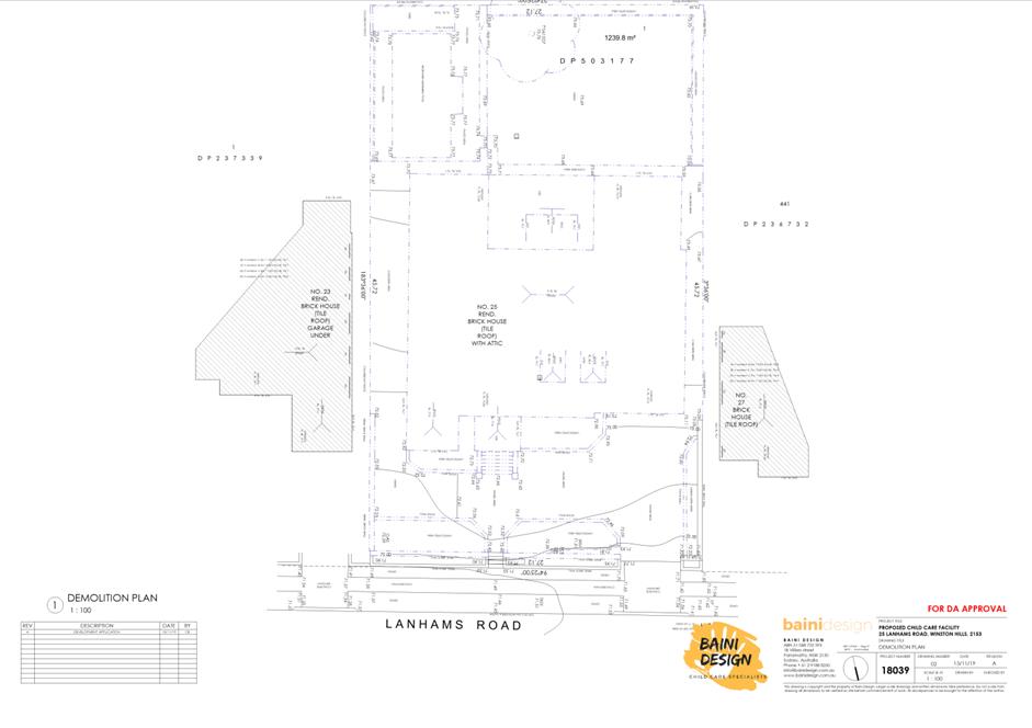
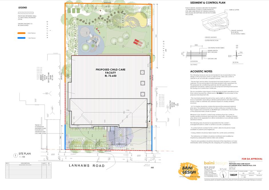
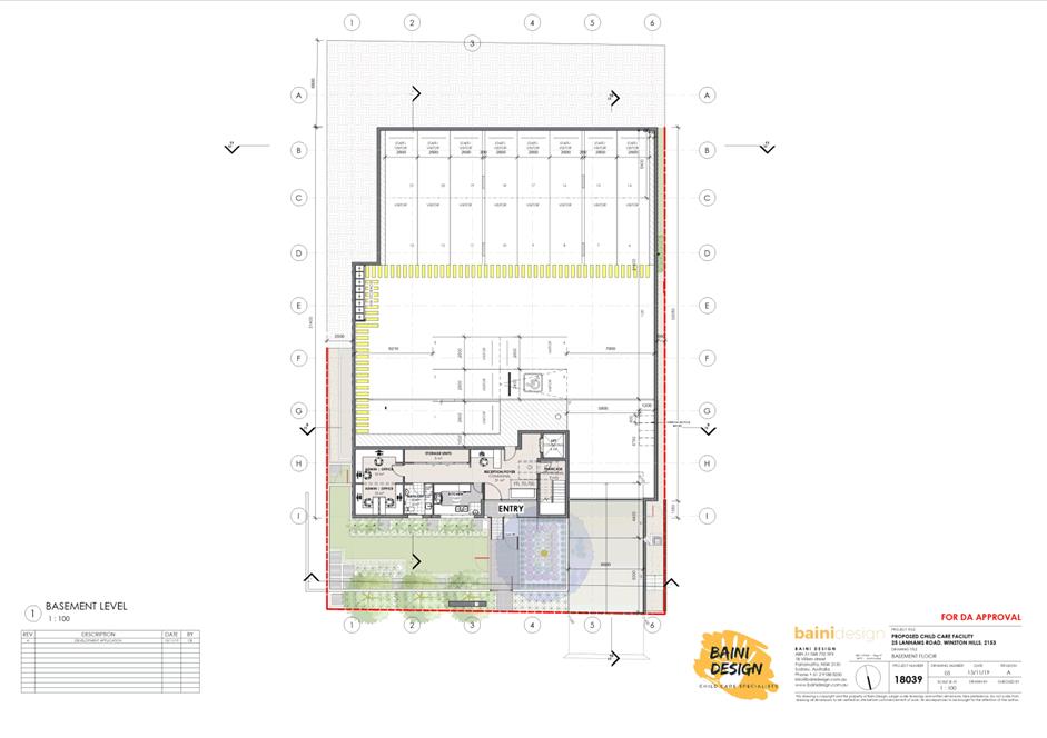
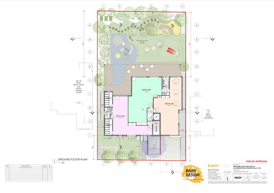
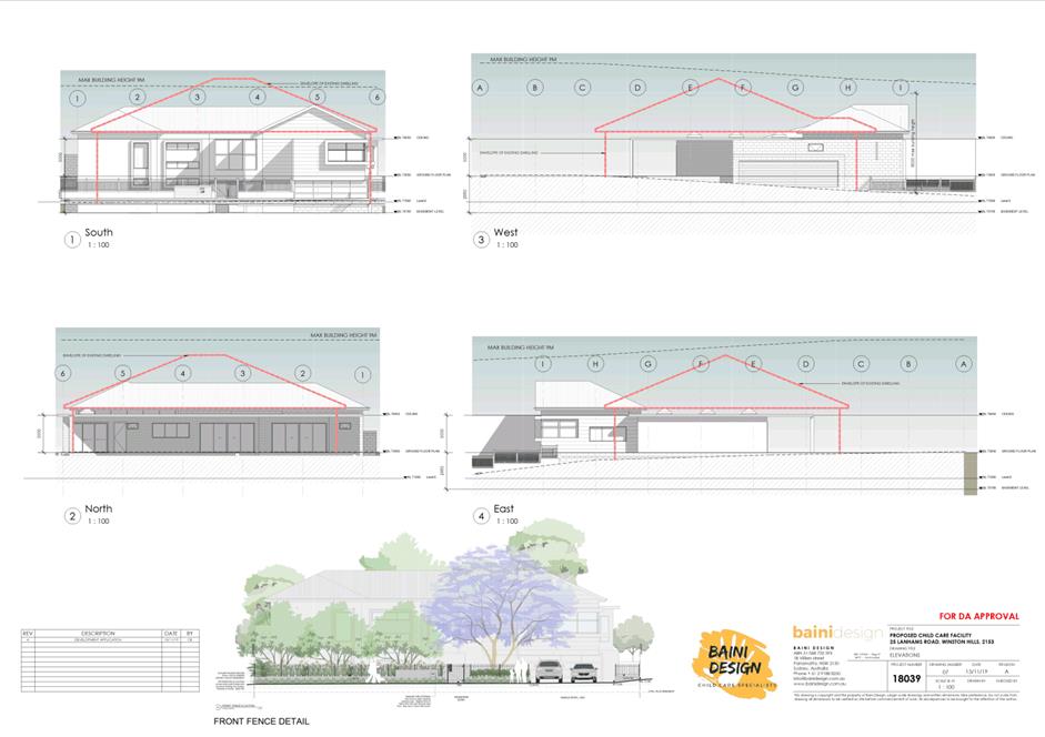
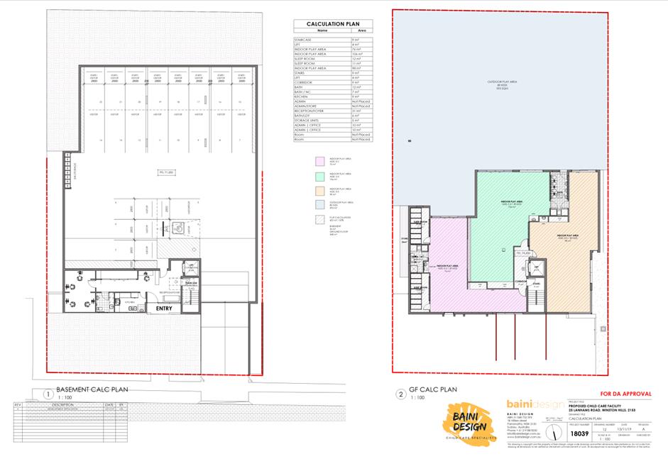
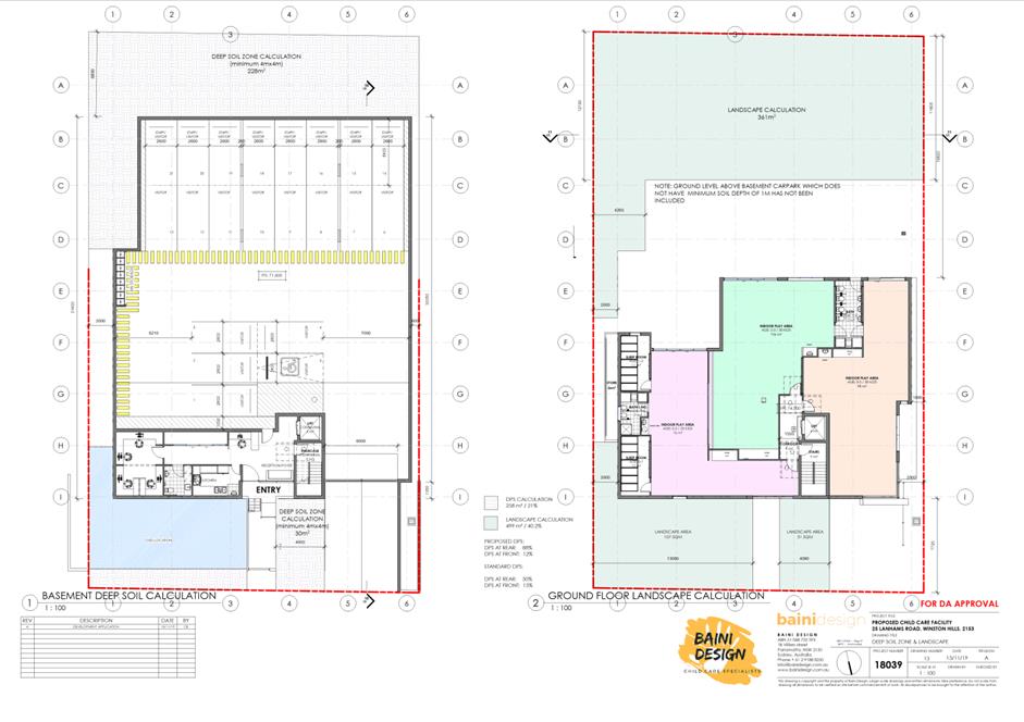
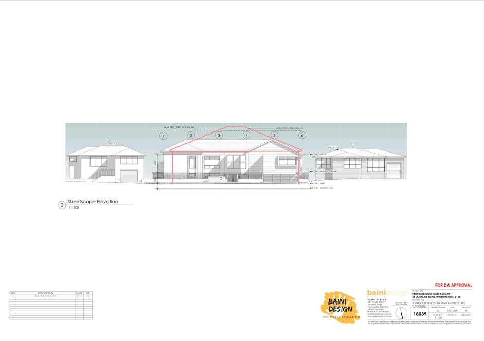
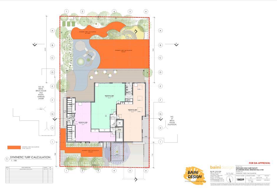
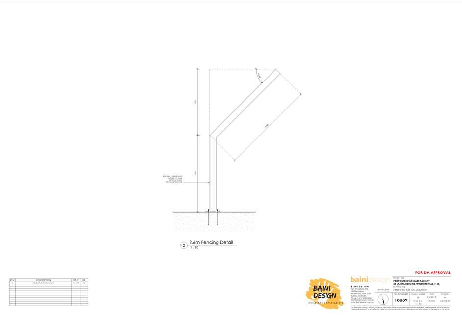
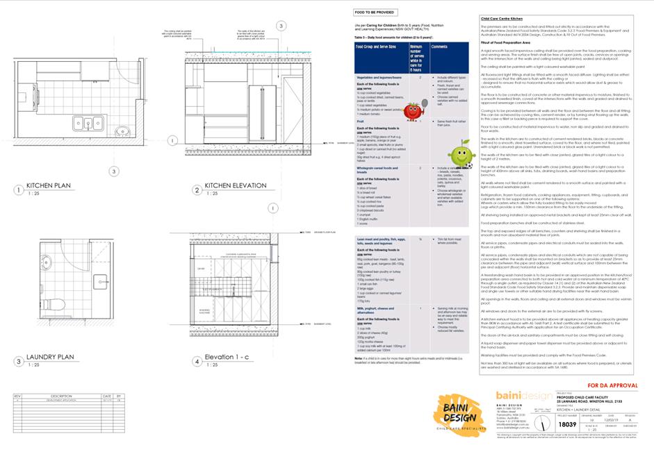
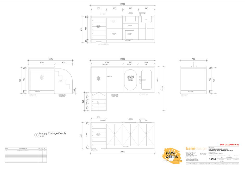
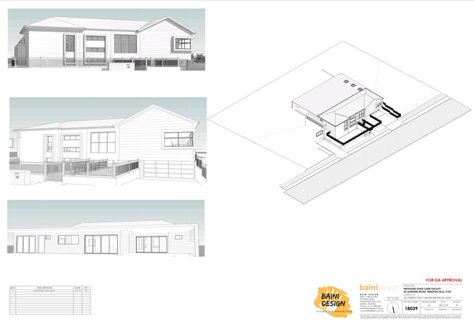
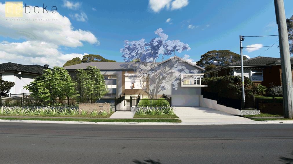
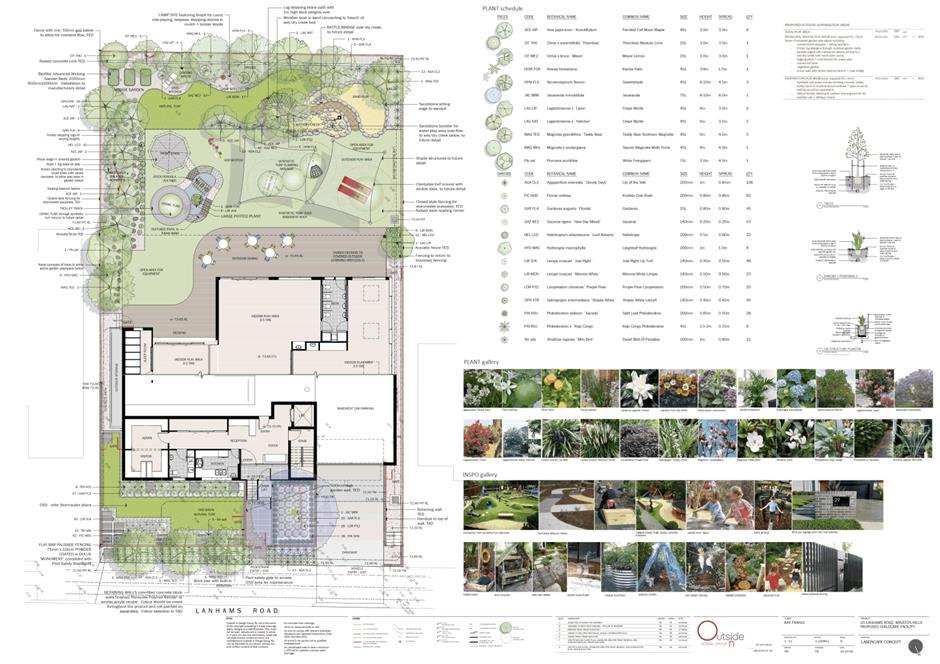
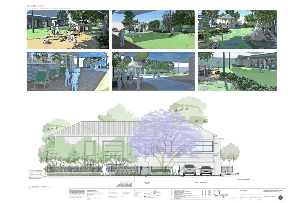
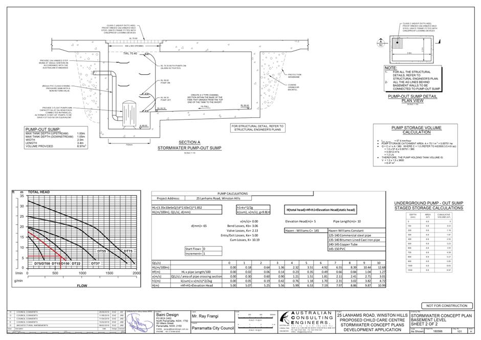
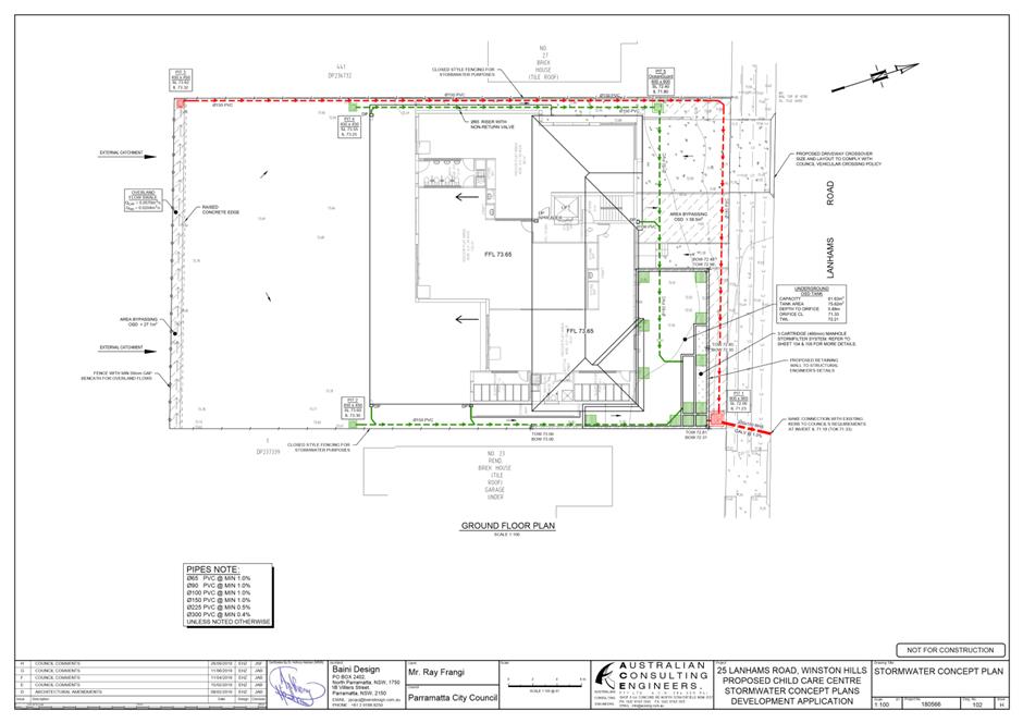
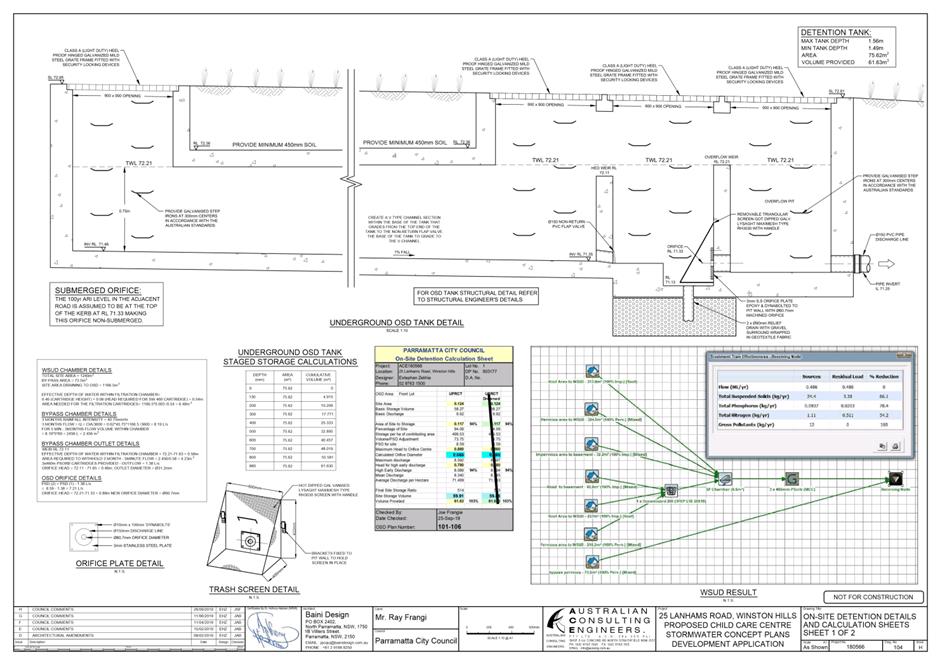
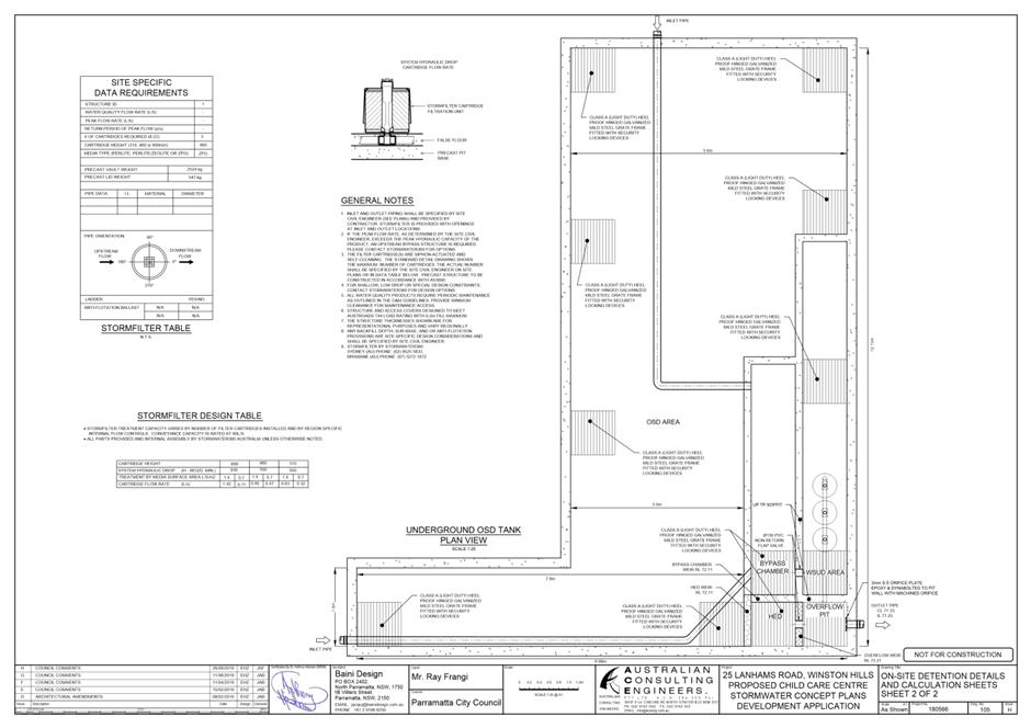
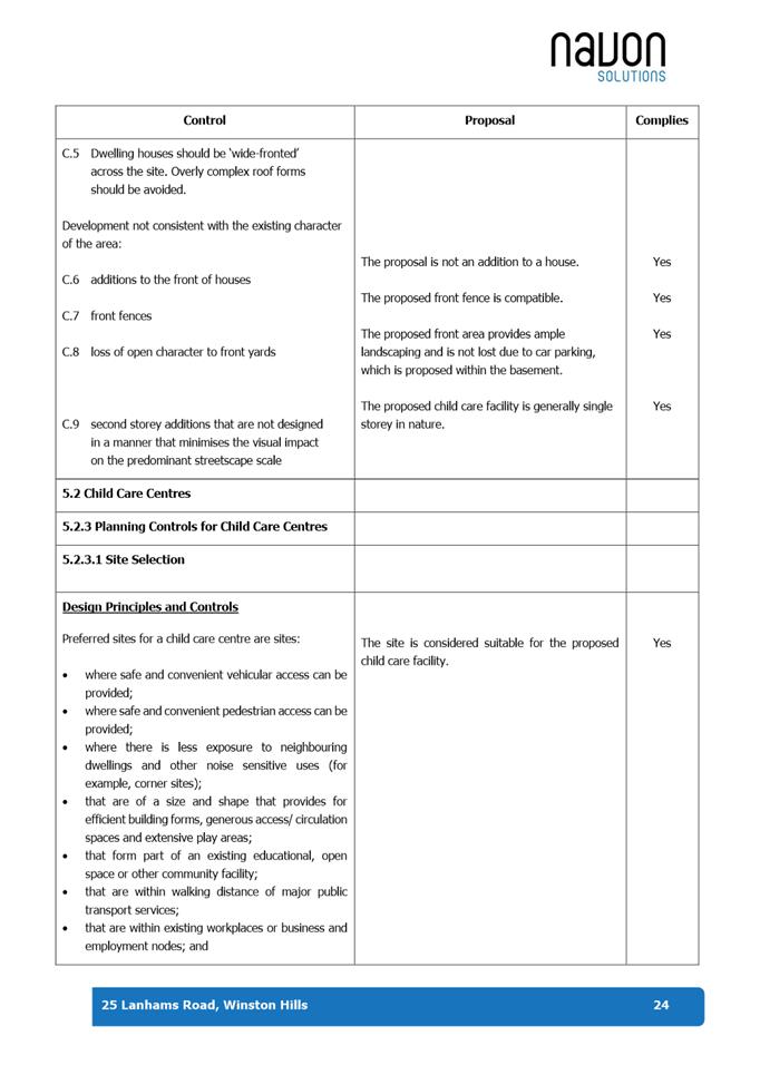
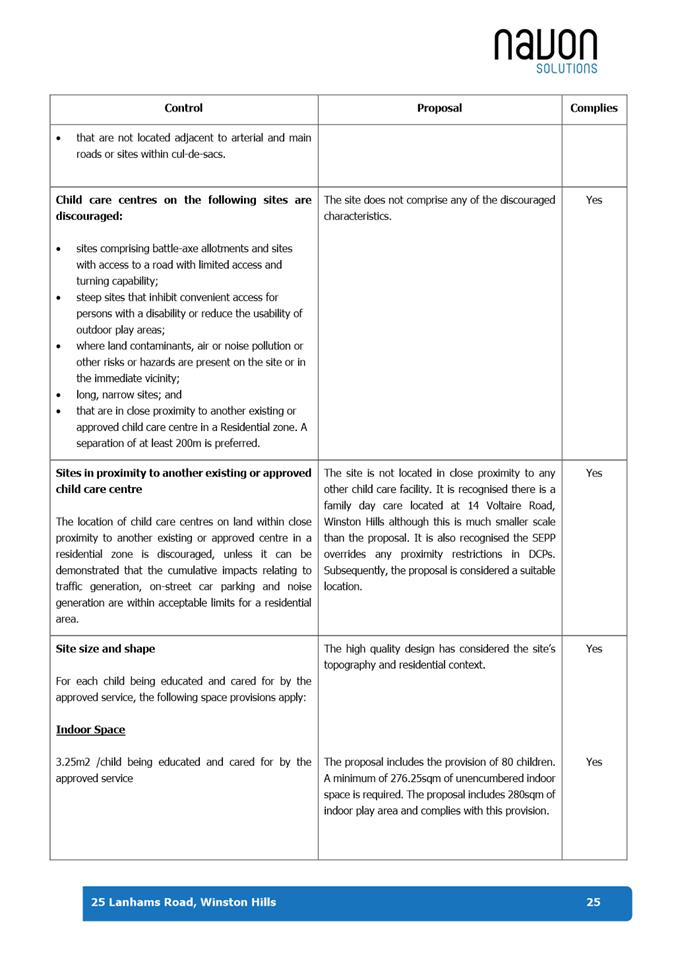
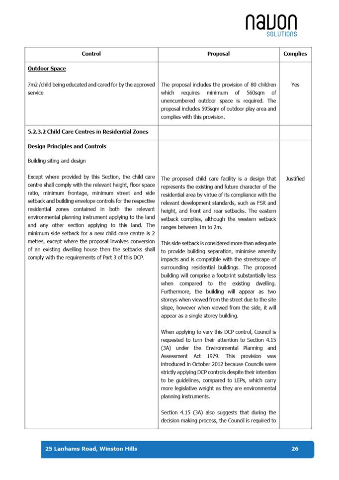
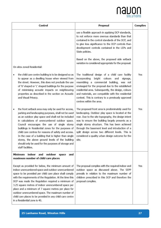
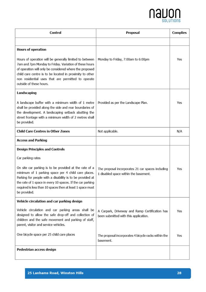
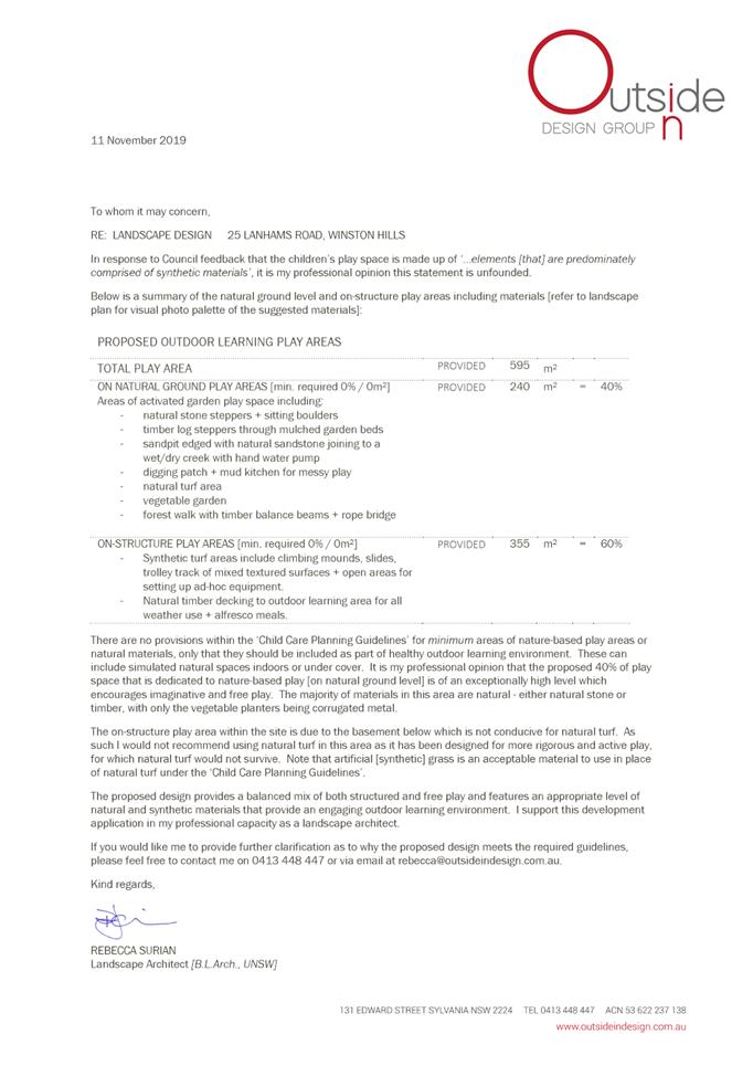
DESCRIPTION Demolition of existing structures and the construction of an 80-place child care facility with associated basement car parking.
REFERENCE DA/716/2019 -
APPLICANT/S Baini Design
OWNERS R and A Frangi
REPORT OF Group Manager Development and Traffic Services
|
DATE OF REPORT 21 APRIL 2020
REASON FOR REFERRAL TO LPP
In accordance with Schedule 2 of the Local Planning Panels Direction for Development Applications 2018, the subject application is required to be determined by the Parramatta Local Planning Panel (PLPP) as more than ten (10) unique submissions by way of objection have been received.
EXECUTIVE SUMMARY
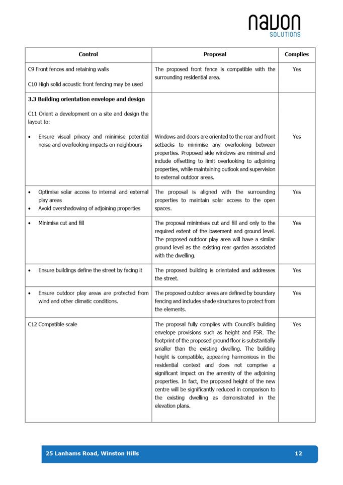
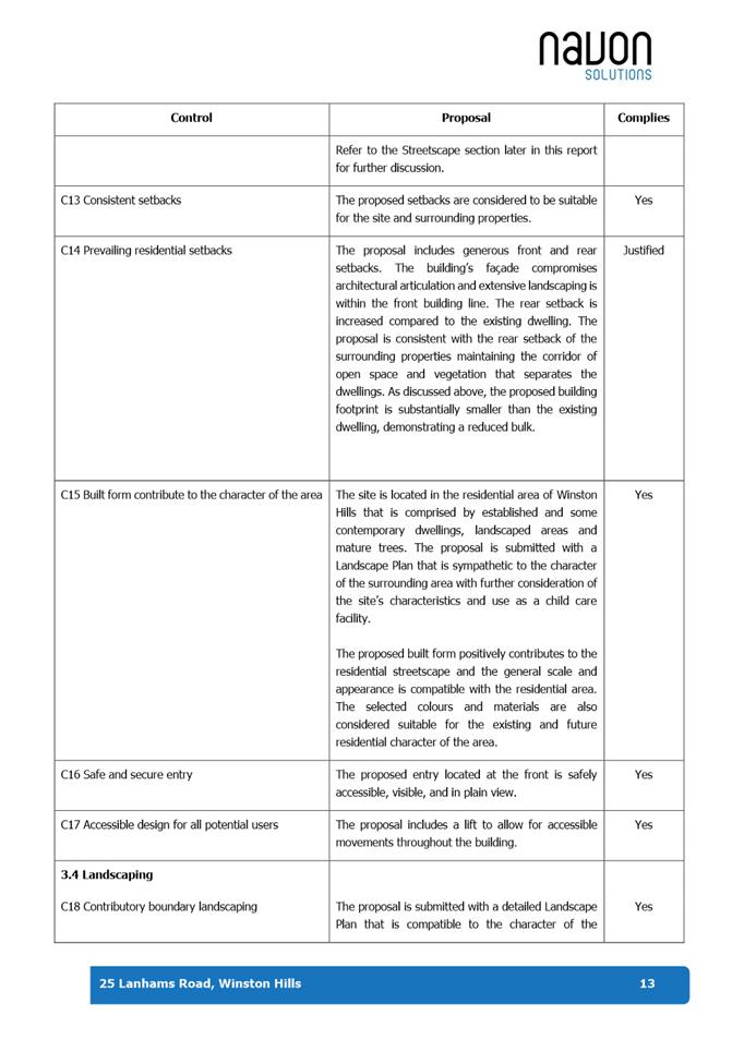
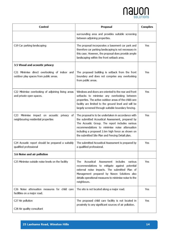
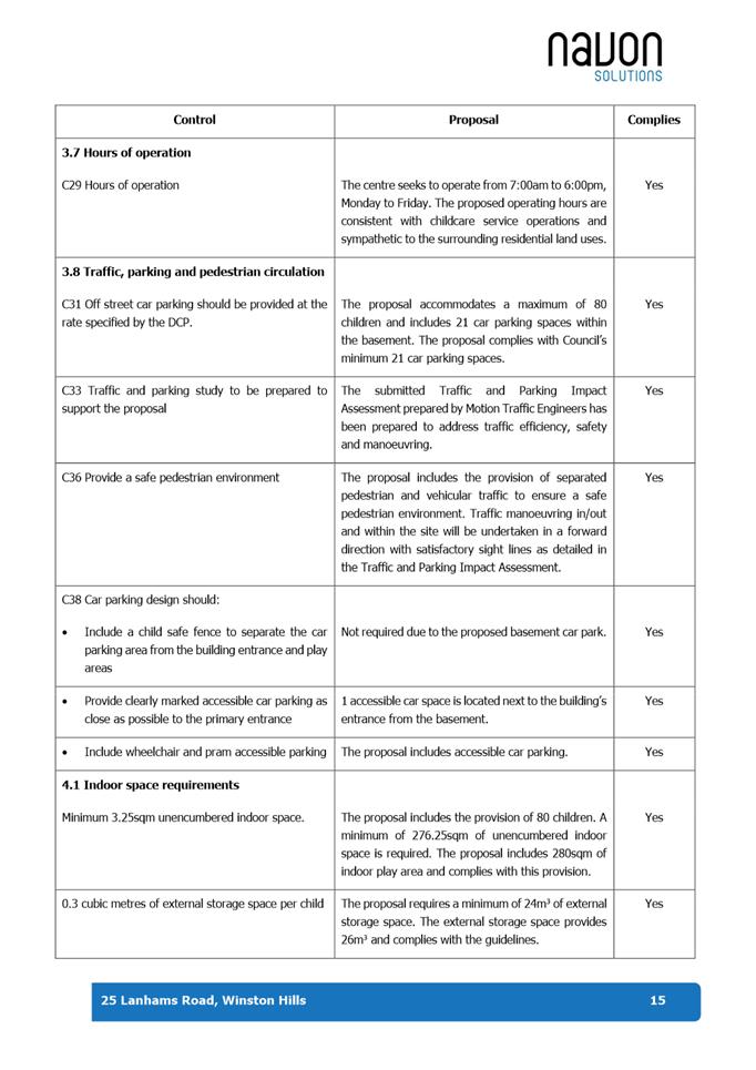
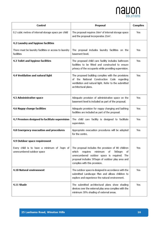
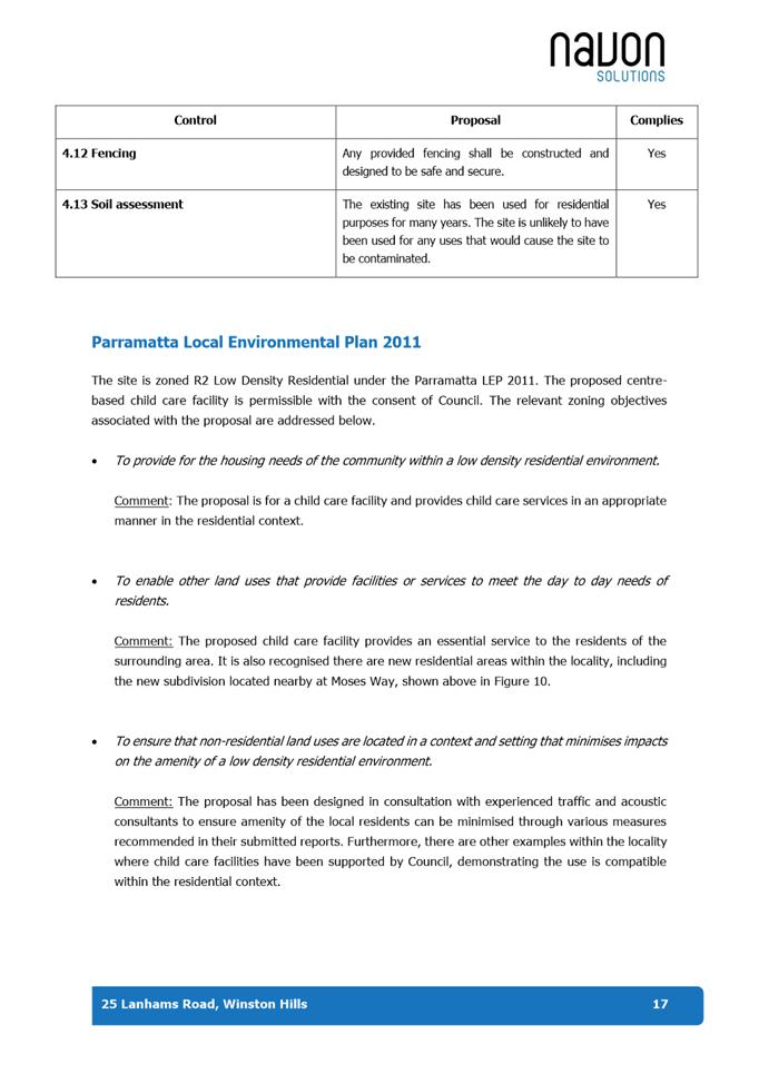
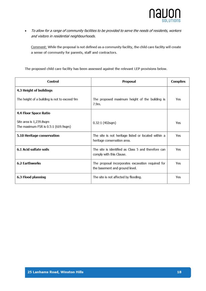
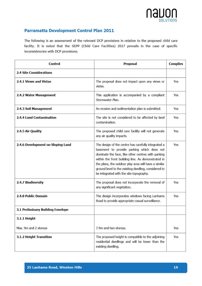
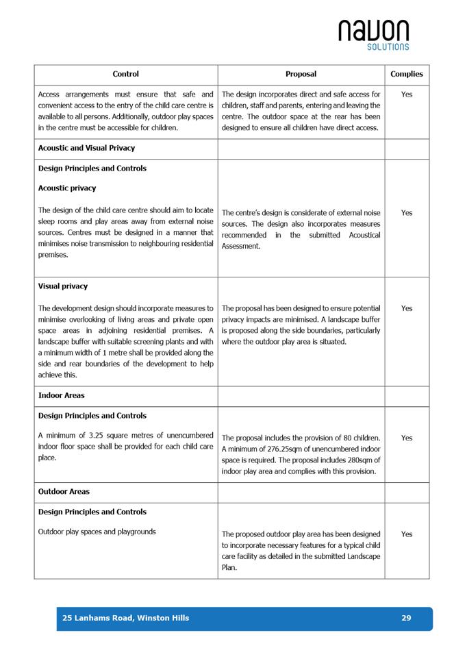
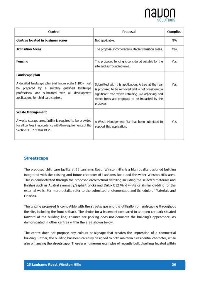
This is a summary of the full assessment of the application as outlined in Attachment 1, the Section 4.15 Assessment Report.
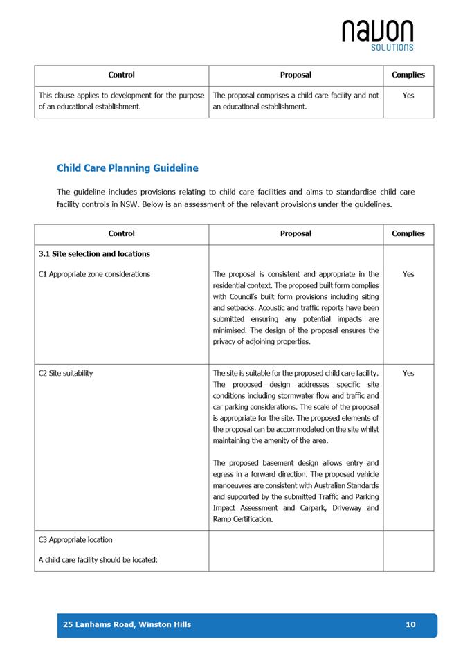
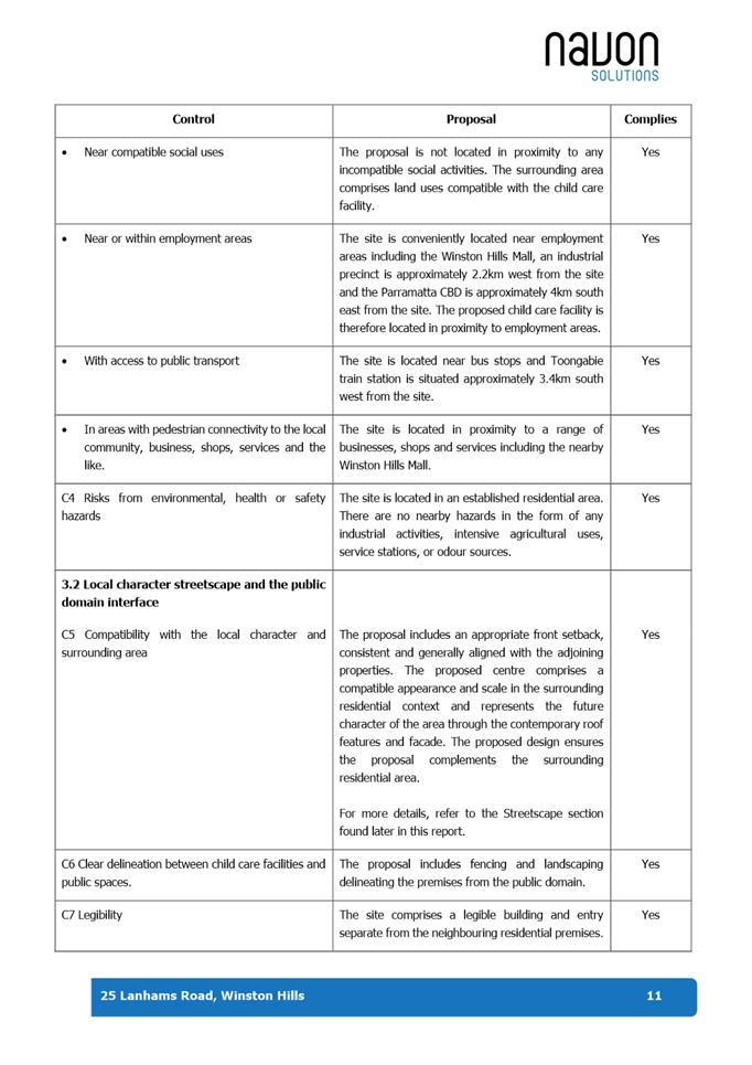
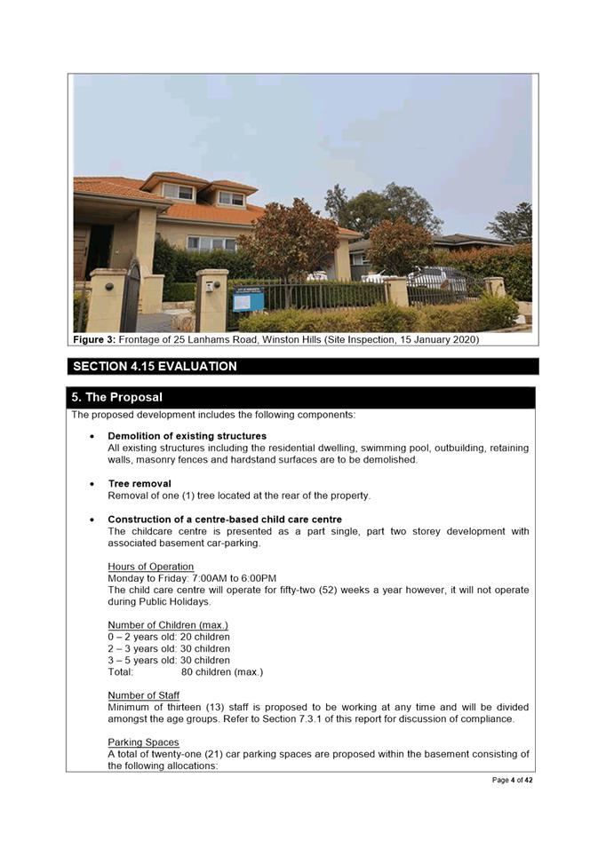
The subject application is for the demolition of existing structures and the construction of an 80-place child care facility with associated basement car parking.
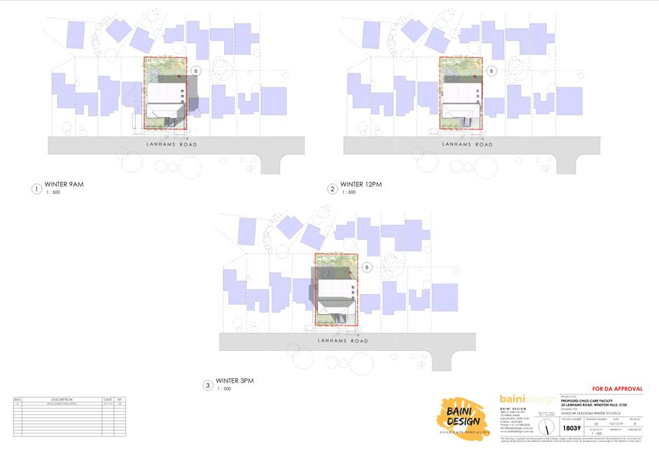
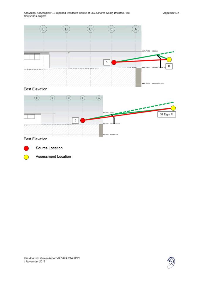
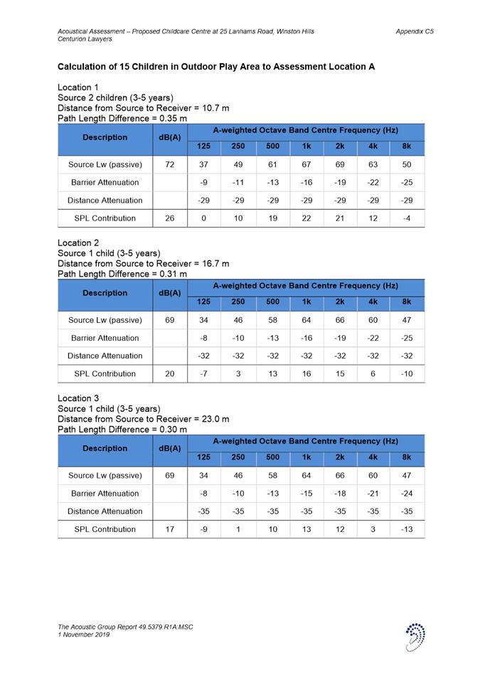
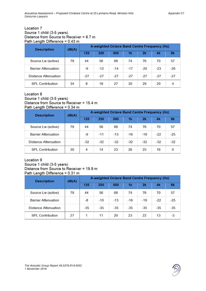
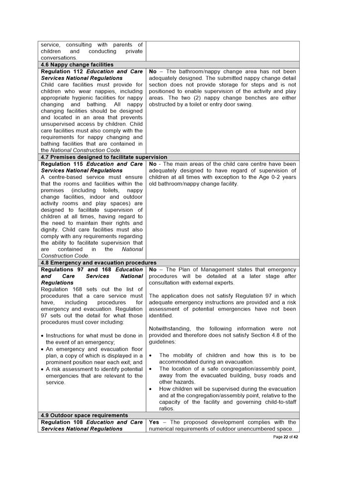
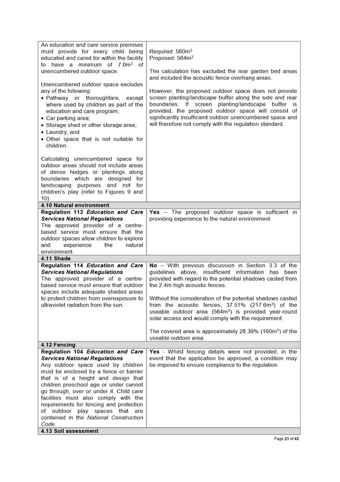
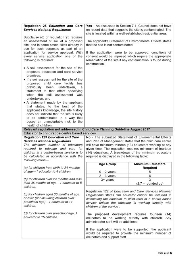
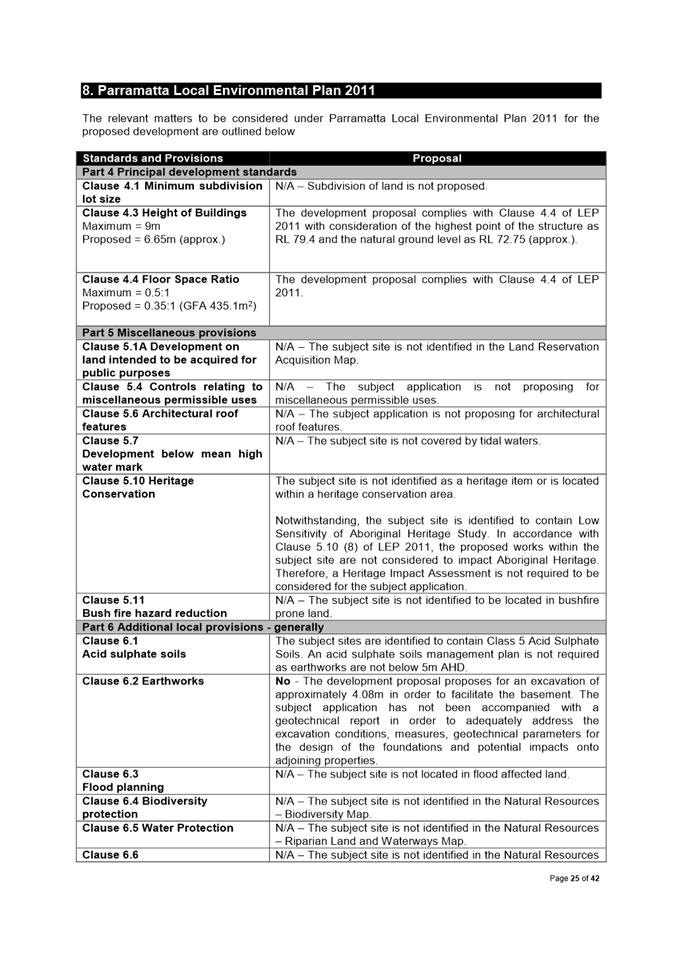
The application has been assessed against the relevant environmental planning instruments, regulations, guidelines and the Parramatta Development Control Plan (DCP) 2011. The subject application has been found unsatisfactory with respect to the aims and objectives of the Child Care Planning Guidelines 2017 and DCP 2011. These issues are predominantly related to bulk and scale, character, acoustic and visual privacy, parking, solar access, stormwater management, waste management and compliance with the regulations. Insufficient and inconsistent information has been received for assessment of the application.
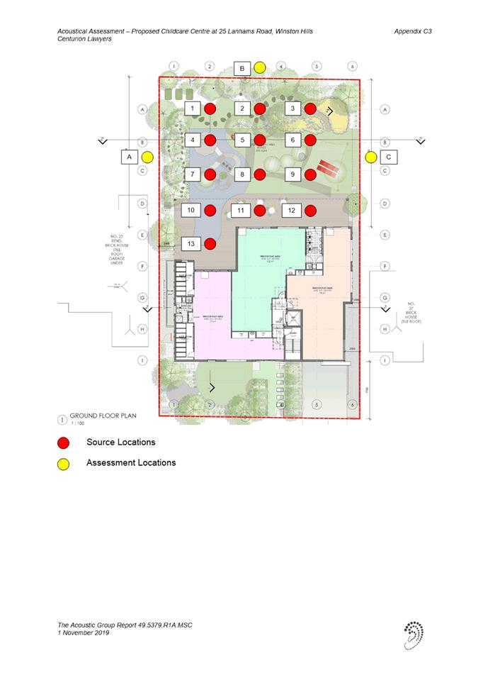
The application was advertised and notified for twenty-two (22) days in accordance with DCP 2011. Twenty-three (23) objections were received during the consultation period. The issues raised in the objections related to acoustic and visual impacts, amount of children proposed, character, siting, hours of operation, traffic and waste management. These are discussed in detail within Attachment 1.
On 14 February 2020, the Applicant notified Council that a Class 1 Appeal was lodged to the NSW Land and Environment Court in accordance with Clause 113 of the Environmental Planning and Assessment Regulation 2000 (deemed refusal period).
With respect to the issues and matters identified above, the application is recommended for refusal for the reasons outlined below.
|
|
REFUSAL Pursuant to Section 4.16(1)(b) of the Environmental Planning and Assessment Act, 1979:
(a) That the Parramatta Local Planning Panel (PLPP) as the consent authority refuse development consent to DA/716/2019 for the demolition of existing structures and the construction of an 80 place child care facility with associated basement car parking at 25 Lanhams Road, Winston Hills NSW 2153 for the reasons outlined in Attachment 1.
(b) Further, that submitters be advised of the Panel’s decision.
|
John Martinez
Development Assessment Officer
|
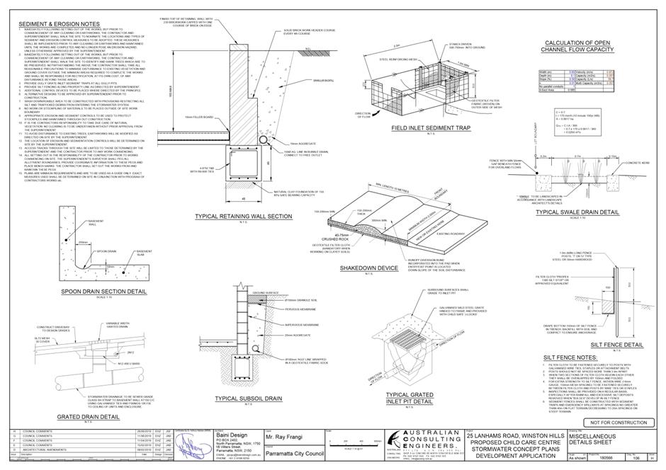
1⇩ |
Attachment 1: Assessment Report |
42 Pages |
|
|
2⇩ |
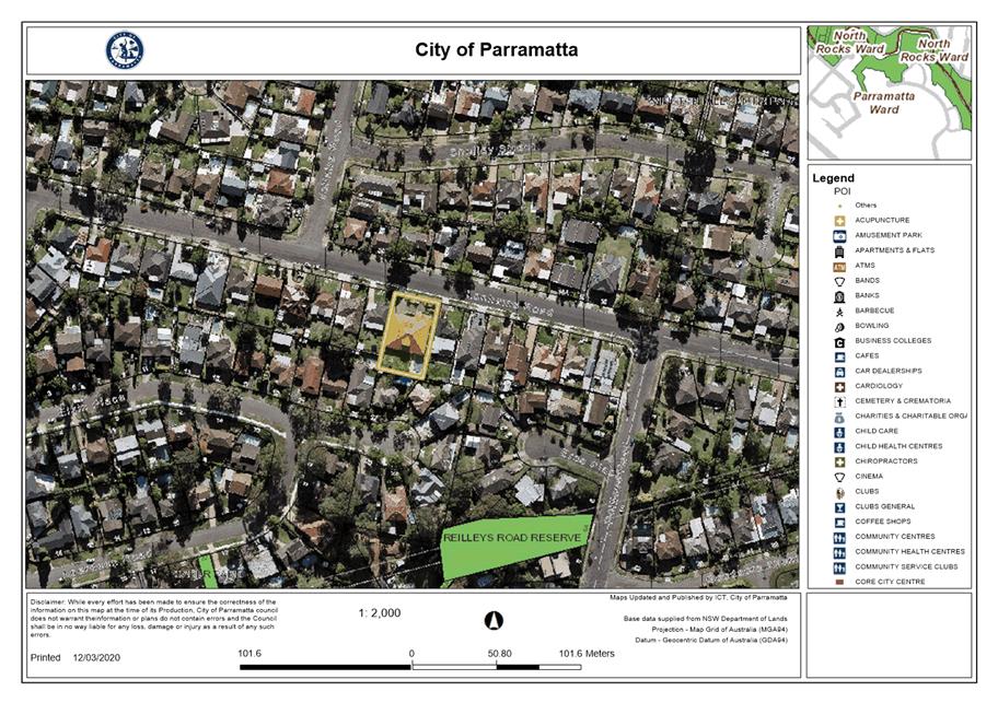
Attachment 2: Locality Map |
1 Page |
|
|
3⇩ |
Attachment 3: Plans used during assessment |
32 Pages |
|
|
4⇩ |
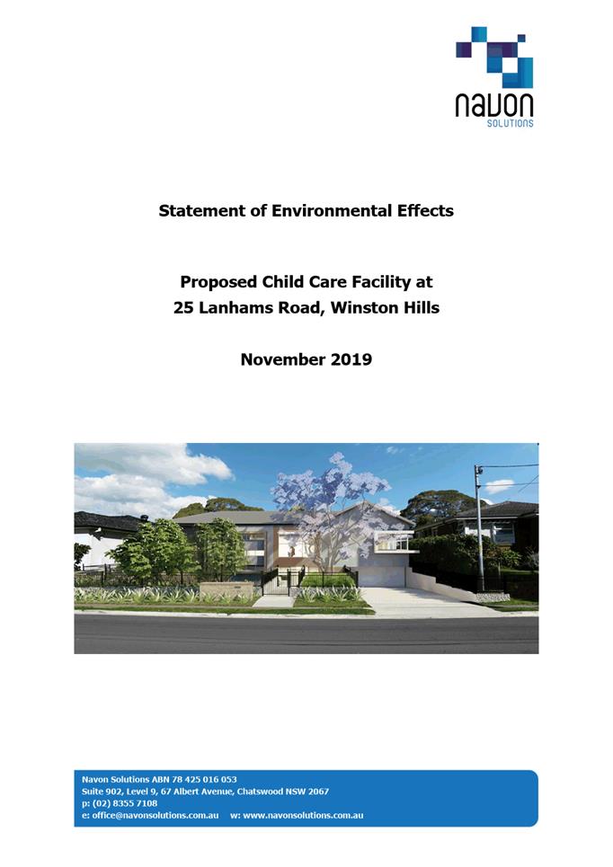
Attachment 4: Statement of Environmental Effects |
33 Pages |
|
|
5⇩ |
Attachment 5: Plan of Management |
8 Pages |
|
|
6⇩ |
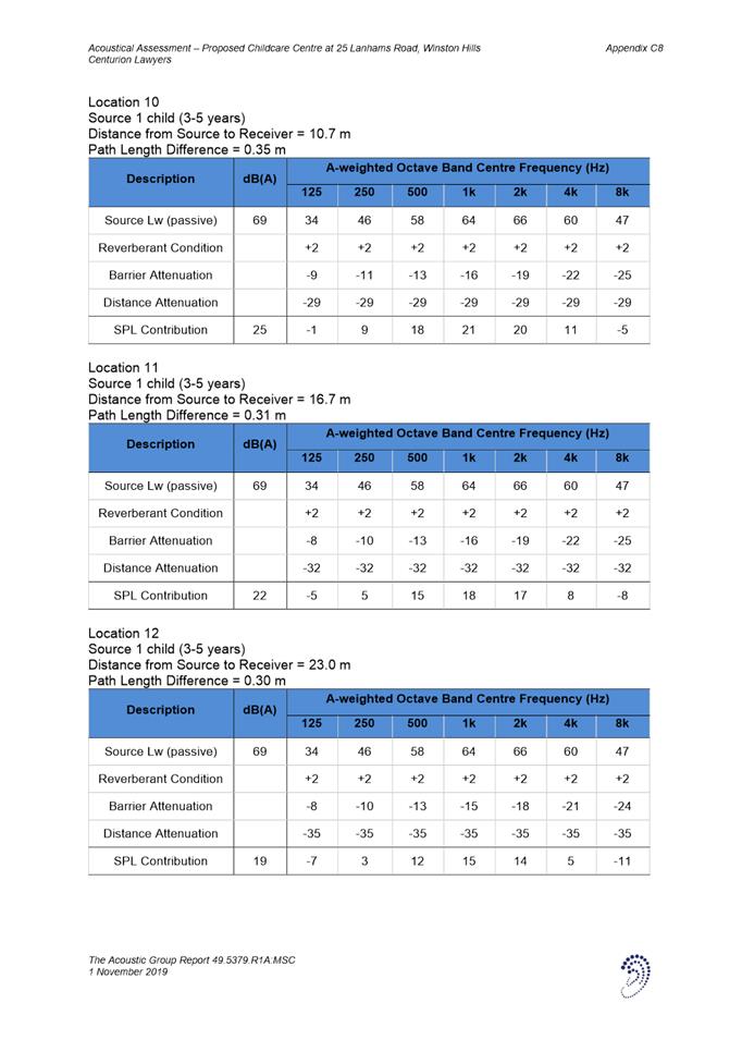
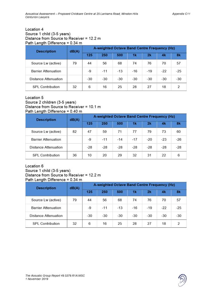
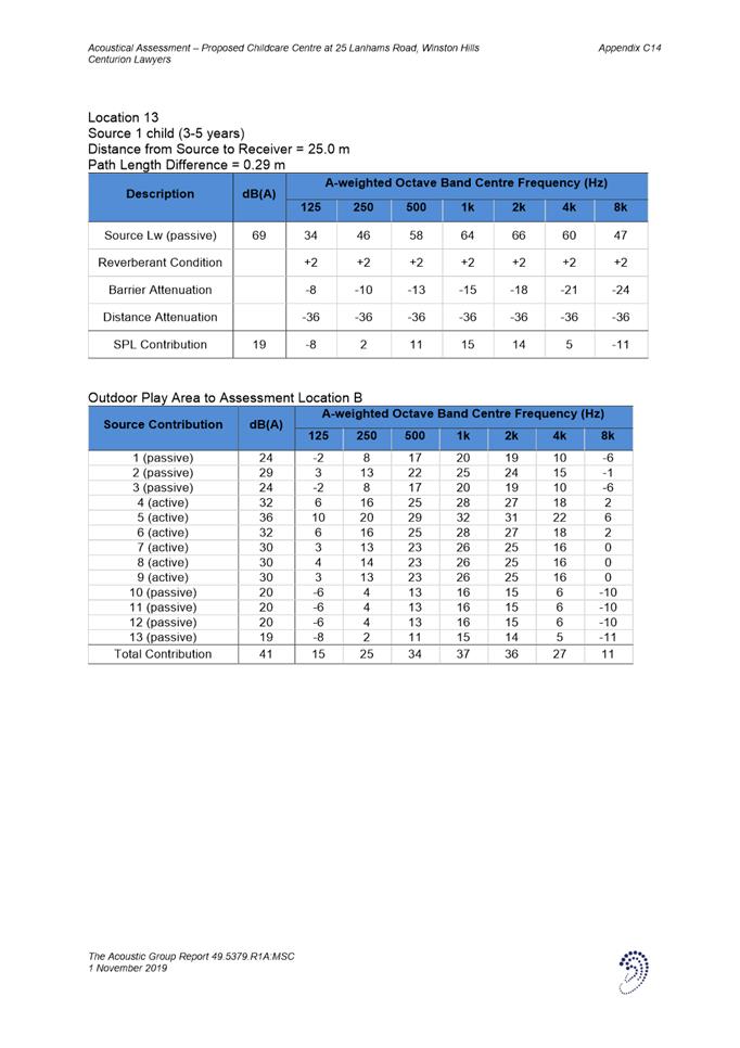
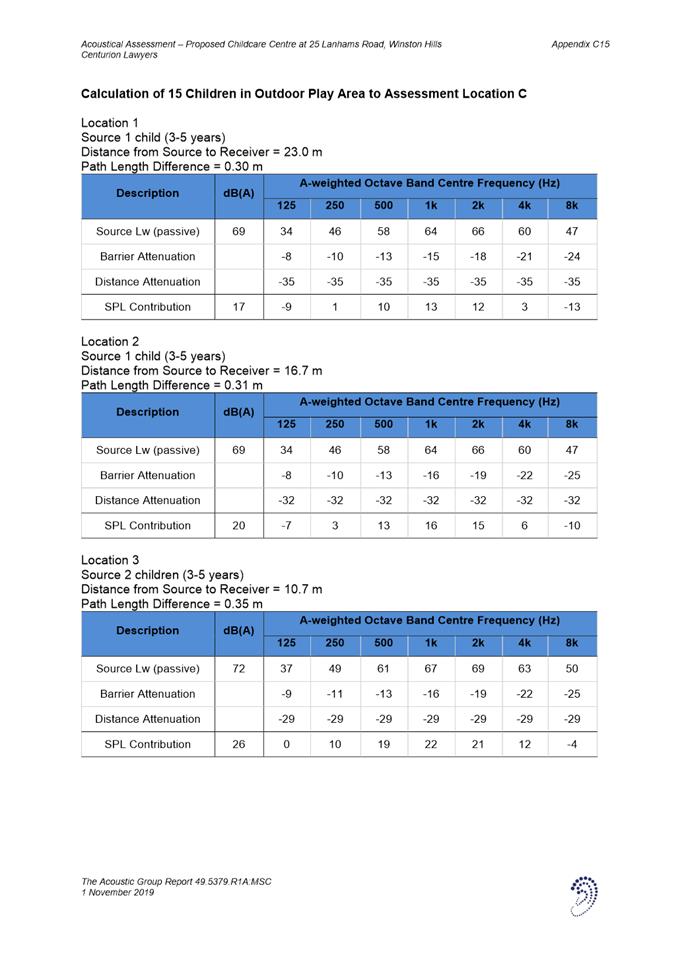
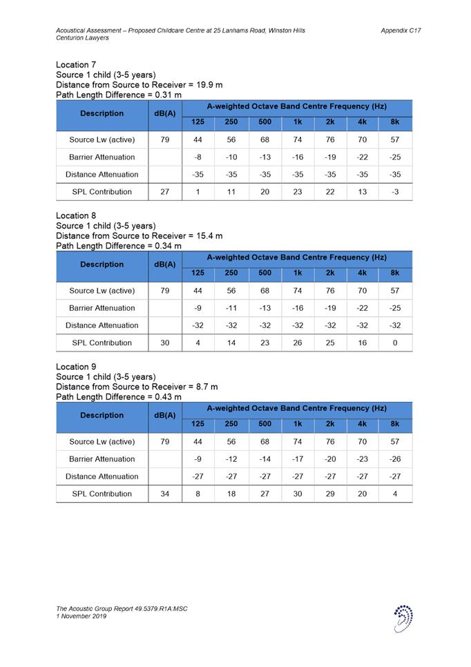
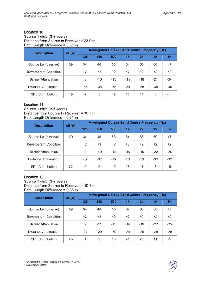
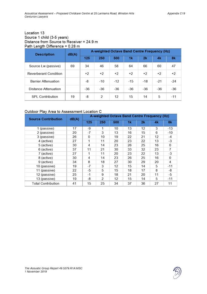
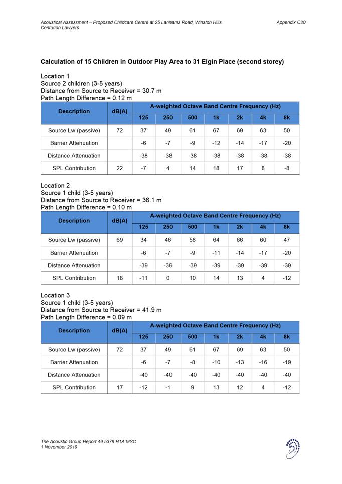
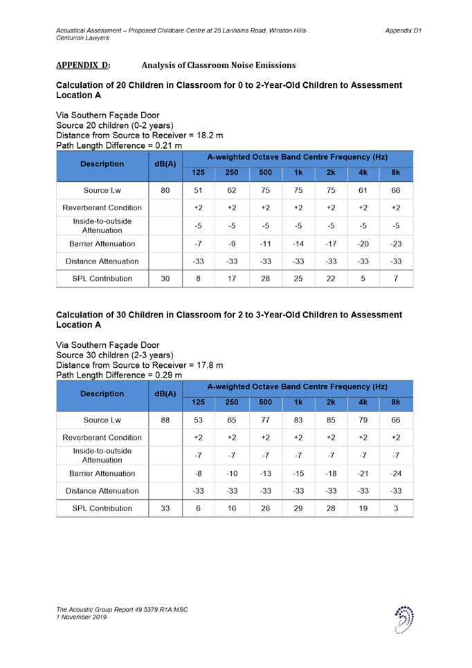
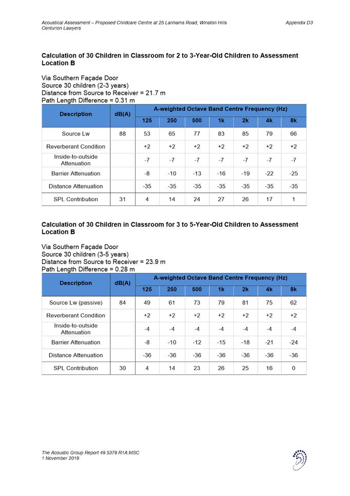
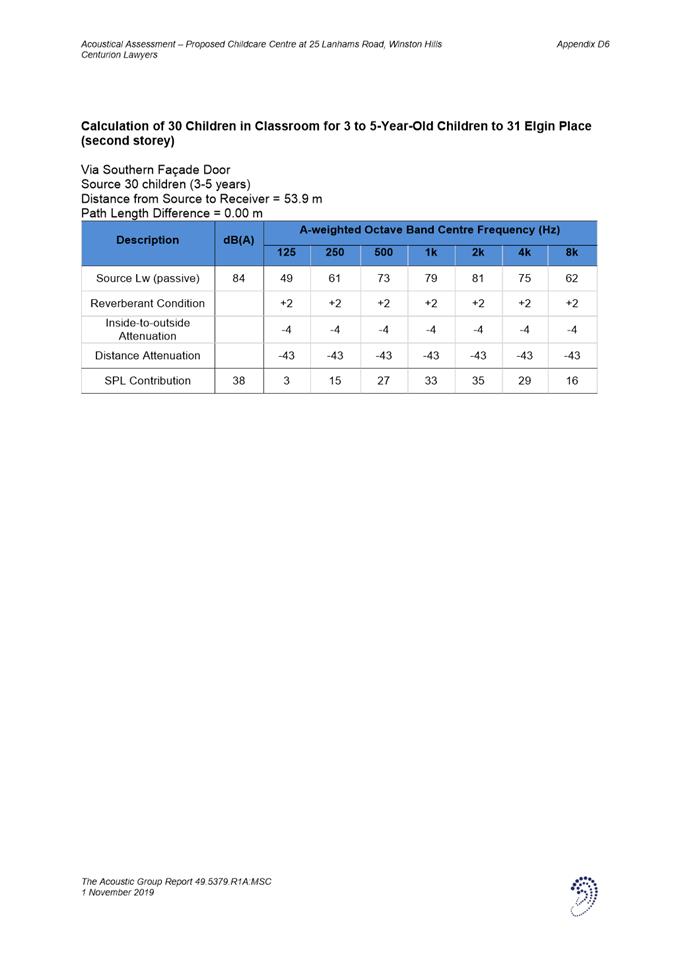
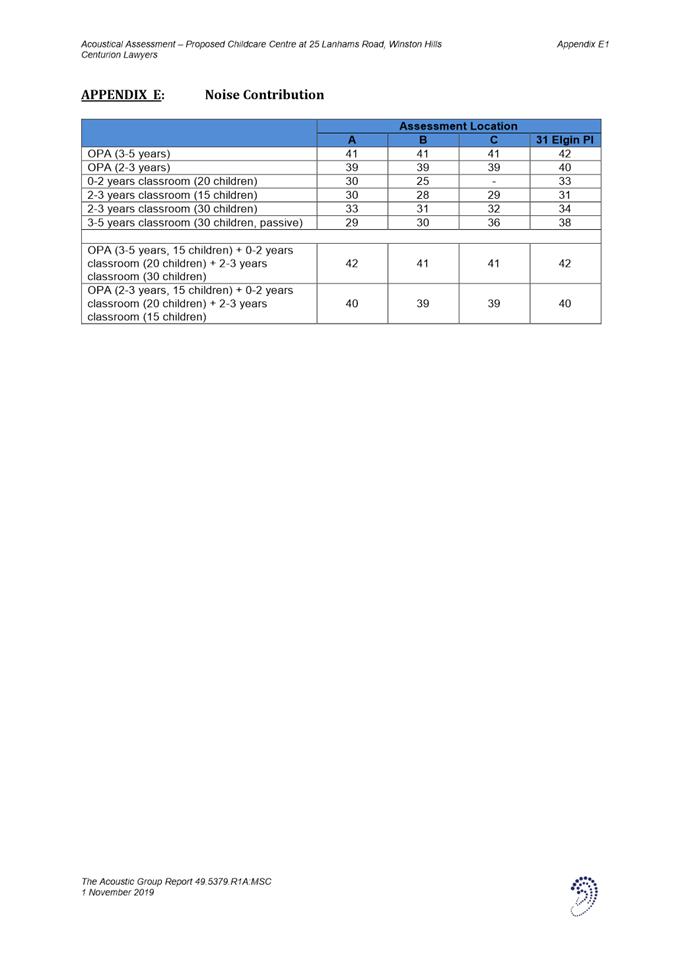
Attachment 6: Acoustic Report |
56 Pages |
|
|
7⇩ |
Attachment 7: Waste Management Plan |
7 Pages |
|
|
8⇩ |
Attachment 8: Landscape Compliance Letter |
1 Page |
|
REFERENCE MATERIAL
Local Planning Panel 21 April 2020 Item 5.2
ITEM NUMBER 5.2
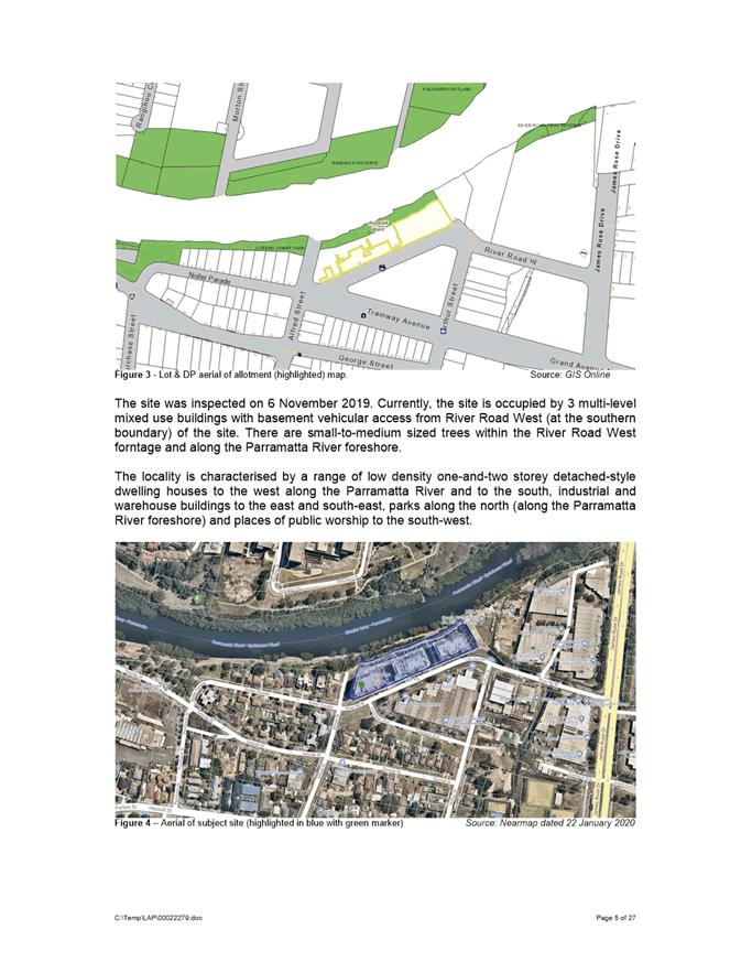
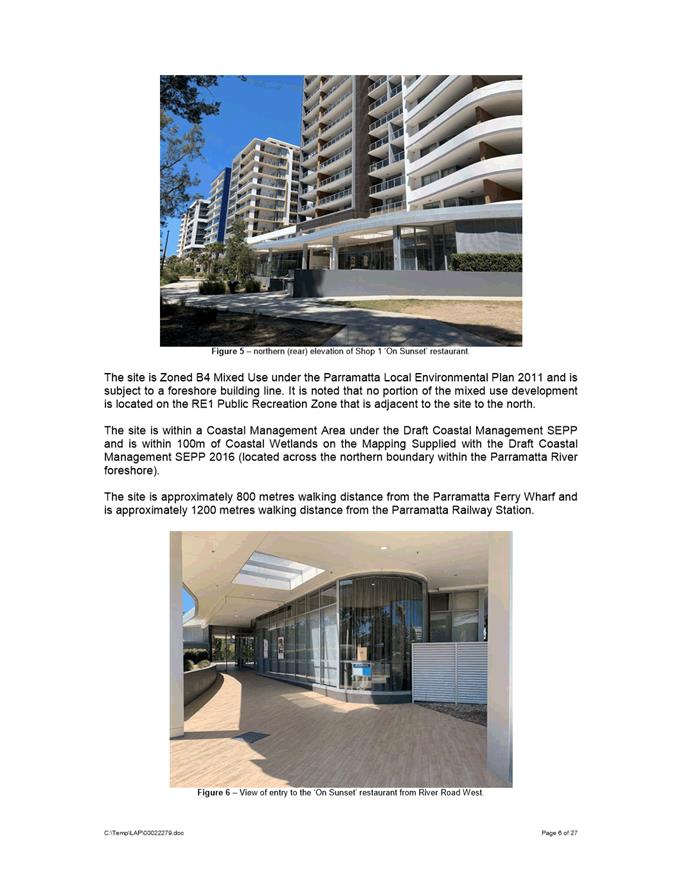
SUBJECT 2-8 River Road West, Parramatta
(Lot 1 in DP 1204213 & CP in SP 94898) (Rosehill Ward)
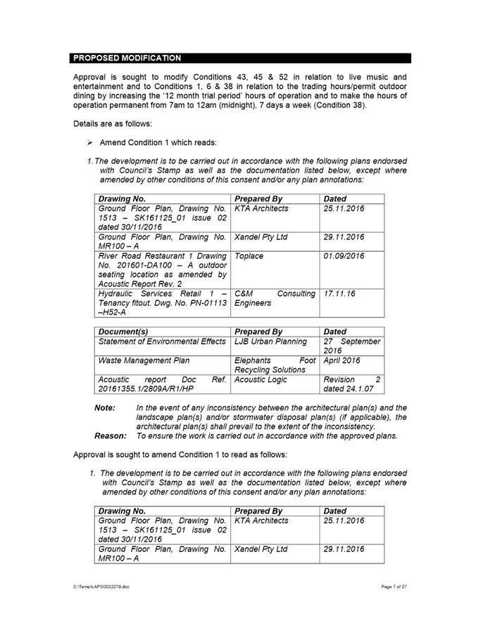
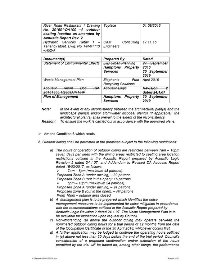
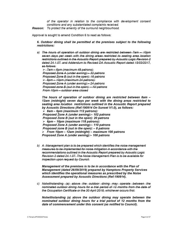
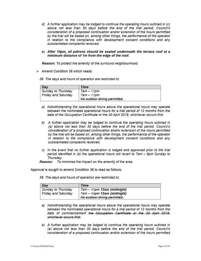
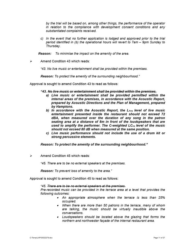
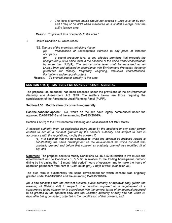
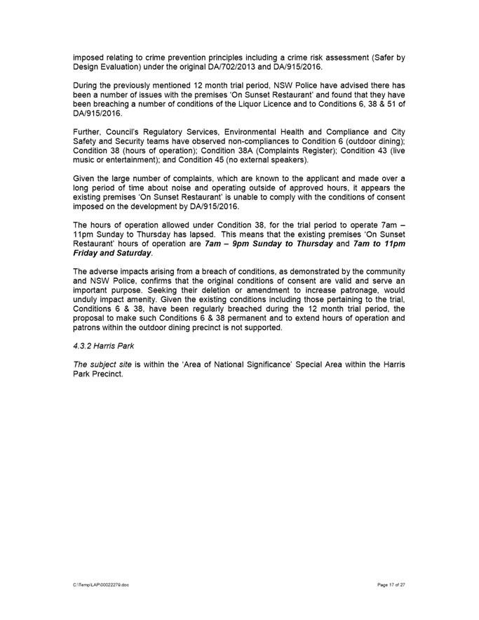
DESCRIPTION Section 4.55(2) modification to DA/915/2016 for the fit-out and use of Shop 1 as a food and drink premises 'On Sunset Restaurant'. The modifications seek to amend Conditions 43, 45 & 52 in relation to live music and entertainment and to Conditions 1, 6 & 38 in relation to the trading hours/permit outdoor dining by increasing the '12 month trial period' hours of operation and to make the hours of operation permanent from 7am until 12am (midnight), 7 days a week.
REFERENCE DA/915/2016/C -
APPLICANT/S On Sunset Pty Ltd
OWNERS Parariver Pty Ltd
REPORT OF Group Manager Development and Traffic Services
|
DATE OF REPORT 19 March 2020
REASON FOR REFERRAL TO LPP
The application is referred to the Parramatta Local Planning Panel (PLPP) as the proposal has received seventy-two (72) unique submissions including 2 petitions against and 1 petition for the development.
EXECUTIVE SUMMARY
This is a summary of the full assessment of the application as outlined in Attachment 1, the Section 4.15/4.55 Assessment Report.
Approval is sought to modify Conditions 43, 45 & 52 in relation to live music and entertainment and to Conditions 1, 6 & 38 in relation to the trading hours/permit outdoor dining by increasing the ‘12 month trial period’ hours of operation and to make the hours of operation permanent from 7am to 12am (midnight), 7 days a week (Condition 38).
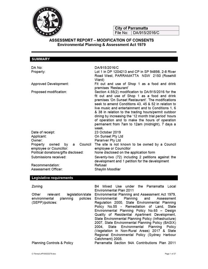
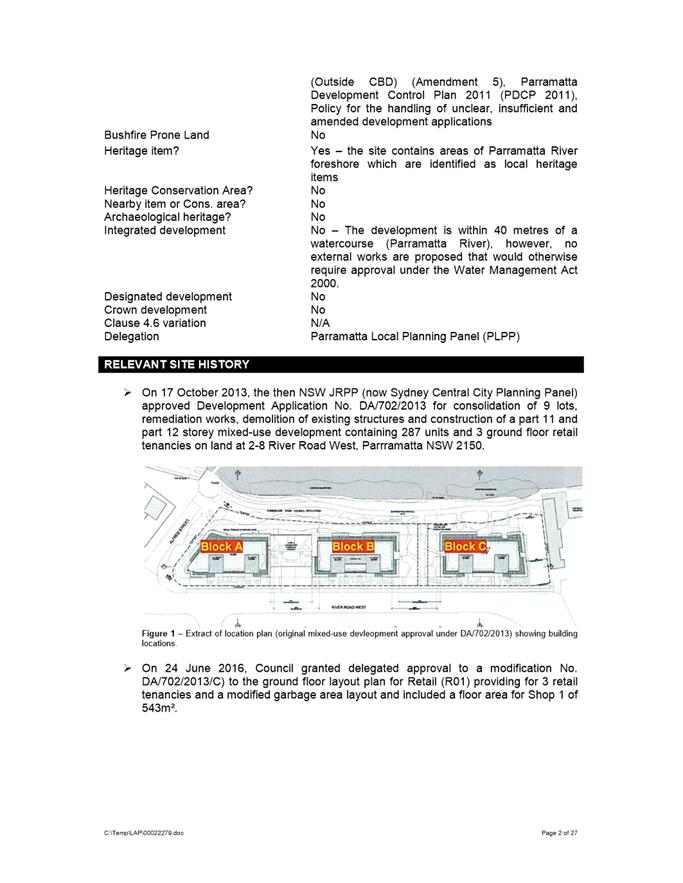
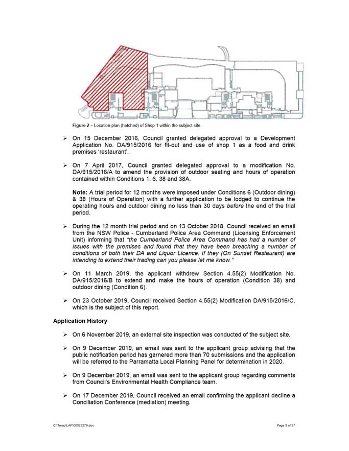
On 15 December 2016, Council granted delegated approval to a Development Application No. DA/915/2016 for fit-out and use of shop 1 as a food and drink premises ‘restaurant’.
On 7 April 2017, Council granted delegated approval to a modification No. DA/915/2016/A to amend the provision of outdoor seating and hours of operation contained within Conditions 1, 6, 38 & 38A. A trial period for 12 months were imposed under Conditions 6 (to permit outdoor dining) & 38 (hours of operation) with a further application to be lodged to continue the operating hours and outdoor dining no less than 30 days before the end of the trial period.
During the 12-month trial period, NSW Police (Cumberland Police Area Command – Licensing Enforcement Unit) have observed a number of operational and management issues with the premises ‘On Sunset Restaurant’ and found that the premises have been breaching a number of conditions of the Liquor Licence and to Conditions 6, 38 & 51 of DA/915/2016/A.
Further, Council’s Regulatory Services, Environmental Health and Compliance and City Safety and Security teams have observed non-compliances to Condition 6 (outdoor dining); Condition 38 (hours of operation); Condition 38A (Complaints Register); Condition 43 (live music or entertainment); and Condition 45 (no external speakers).
The proposal was notified in accordance with the provisions of PDCP 2011. Seventy-two (72) unique submissions and 2 petitions were received against the devleopment whilst 1 petition for the devleopment was received. Issues raised within the submissions relate to breach to the existing conditions of consent, hours of operation, traffic and parking within the streets, smoke from cooking and cigarettes (including shisha or hookah) entering residential apartments above, noise from patrons, loud and live music, unruly behaviour of patrons, illegal car parking on grass verges and along the Parramatta River cycleway and illegal use of common areas under SP 94898.
A merit assessment of the application has determined that the proposal will not be satisfactory and results in unreasonable impacts to the adjoining properties, with regard to adverse noise impacts and hours of operation resultant from the non-compliance with Conditions 6, 38, 38A, 43, 45 & 51 of the development consent DA/915/2016.
The amenity impacts on surrounding residential properties is unreasonable based on the existing non-compliances with the hours of operation and outdoor dining Conditions 6 & 38. Given the number of complaints from adjoining residents over a period of time, Council considers the proposed modification is not a suitable use of the site and approval of the proposal is not in the public interest.
After consideration of the proposal against Sections 4.15 & 4.55 of the Environmental Planning and Assessment Act 1979, and the relevant statutory and policy provisions, the proposal is not suitable for the site and is not in the public interest. The proposal is recommended for refusal.
|
|
(a) That the Parramatta Local Planning Panel (PLPP), exercising the functions of Council, pursuant to Section 4.16(1)(b) of the Environmental Planning and Assessment Act 1979, refuse Section 4.55(2) modification to DA/915/2016 for the fit out and use of Shop 1 as a food and drink premises ‘On Sunset Restaurant’. The modifications seek to amend Conditions 43, 45 & 52 in relation to live music and entertainment and to Conditions 1, 6 & 38 in relation to the trading hours/permit outdoor dining by increasing the ‘12 month trial period’ hours of operation and to make the hours of operation permanent from 7am to 12am (midnight), 7 days a week on land at Lot 1 in DP 1204213 and CP in SP 94898, 2-8 River Road West, Parramatta NSW 2150 for the reasons stated in Attachment 1.
(b) Further, that the objector’s be advised of PLPP’s decision.
|
Shaylin Moodliar
Senior Development Assessment Officer
|
1⇩ |
Attachment 1: Assessment Report |
27 Pages |
|
|
2⇩ |
Attachment 2: Locality Map |
1 Page |
|
|
Attachment 3: NSW Police Referral Response (confidential) |
10 Pages |
|
|
|
Attachment 4: Environmental Health Referral Responses (confidential) |
15 Pages |
|
|
|
Attachment 5: City of Parramatta City Safety & Security Referral Response (confidential) |
8 Pages |
|
REFERENCE MATERIAL
Local Planning Panel 21 April 2020 Item 5.3
ITEM NUMBER 5.3
SUBJECT 26 Iona Avenue, North Rocks
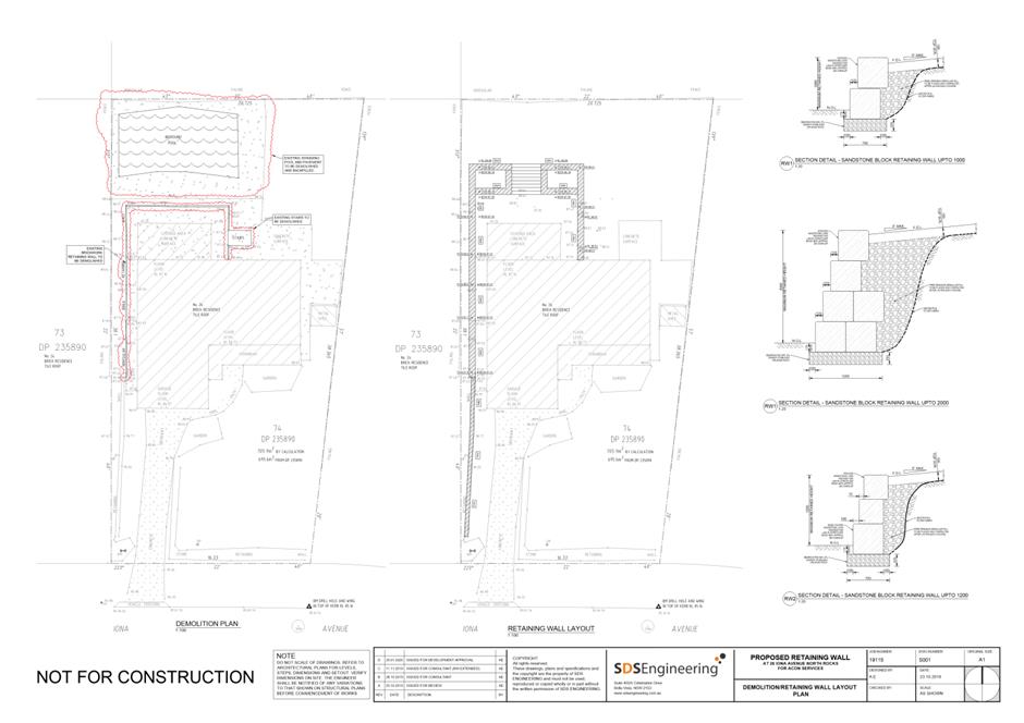
DESCRIPTION Infill of existing swimming pool, demolition of rear steps & retaining wall and construction of new steps and retaining wall.
REFERENCE DA/54/2020 -
APPLICANT/S Acon Services
OWNERS Mrs J L Hsu
REPORT OF Group Manager Development and Traffic Services
|
DATE OF REPORT 21 APRIL 2020
REASON FOR REFERRAL TO LPP The application is referred to Parramatta Local Planning Panel for determination as the subject site is owned by a Councillor.
EXECUTIVE SUMMARY This is a summary of the full assessment of the application as outlined in Attachment 1, the Section 4.15 Assessment Report.
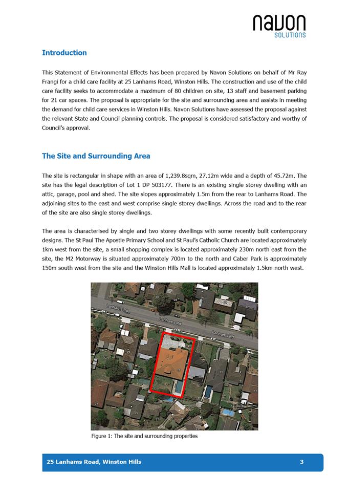
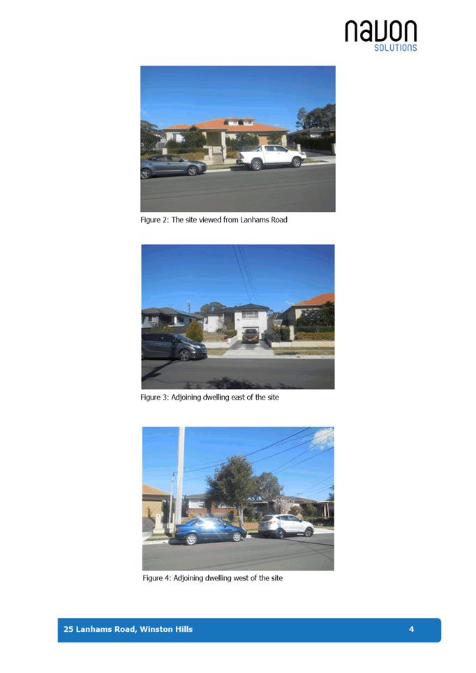
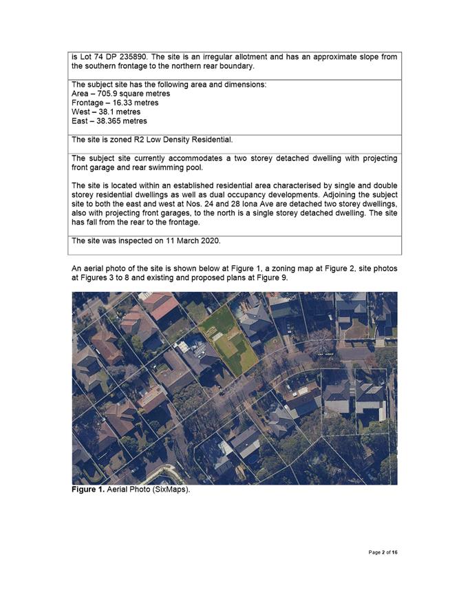
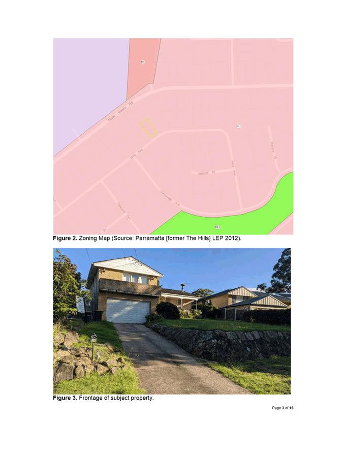
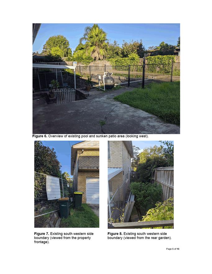
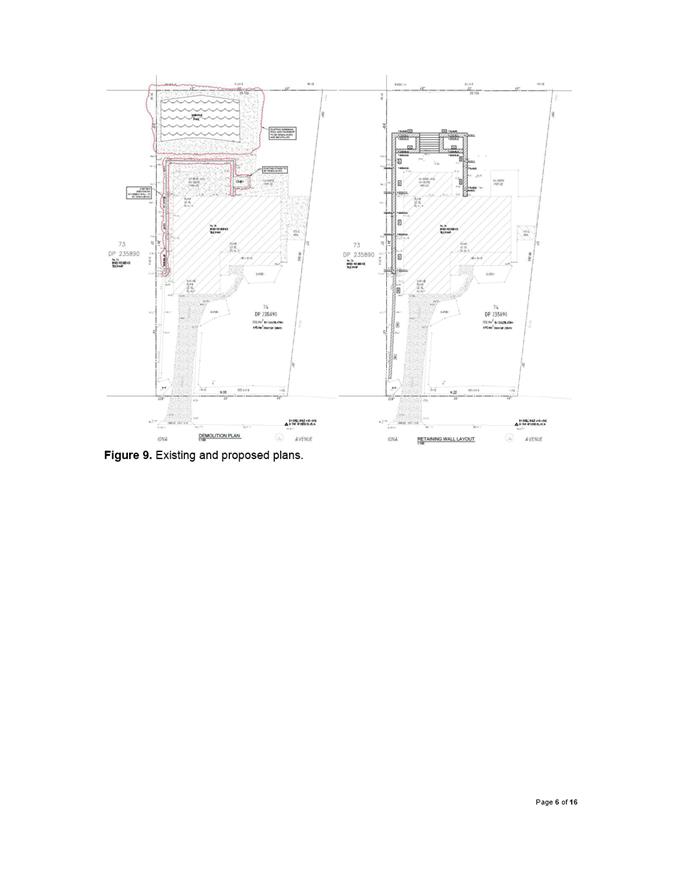
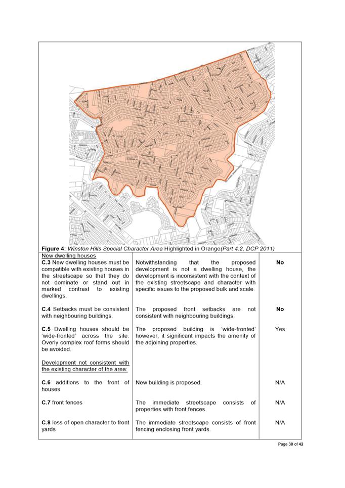
The Site The subject site is known as 26 Iona Avenue, North Rocks. The current property description is Lot 74 DP 235890. The site is an irregular allotment and slopes from the southern frontage to the northern rear boundary.
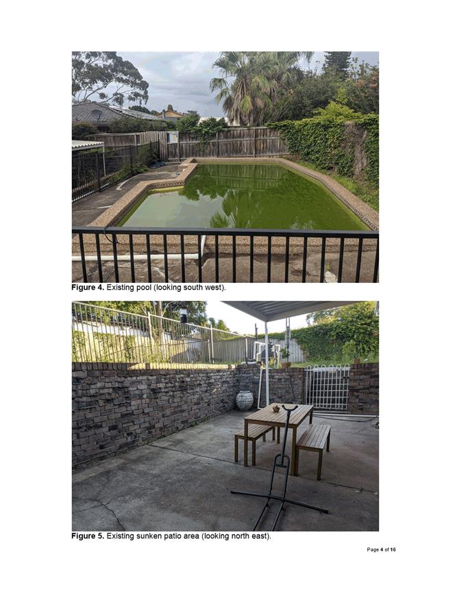
The subject site currently accommodates a two storey detached dwelling with projecting front garage and rear swimming pool.
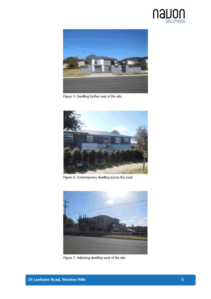
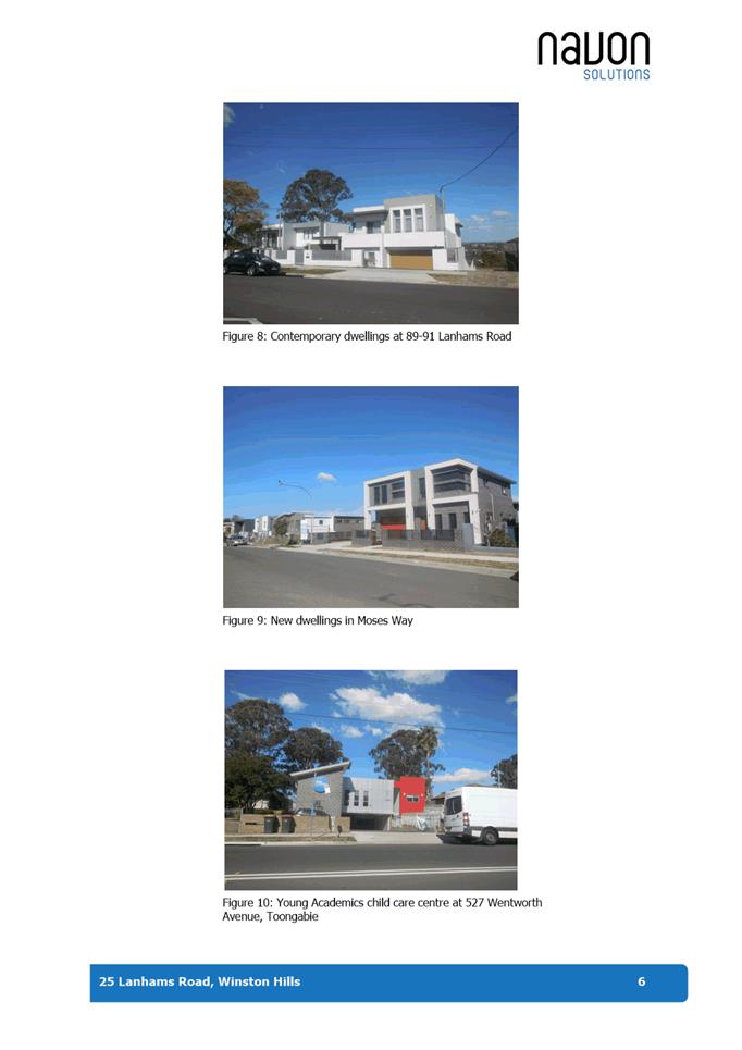
The site is located within an established residential area characterised by single and double storey residential dwellings as well as dual occupancy developments. Adjoining the subject site to both the east and west at Nos. 24 and 28 Iona Ave are detached two storey dwellings, also with projecting front garages, to the north is a single storey detached dwelling. The site has fall from the rear to the frontage.
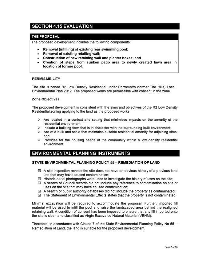
Proposed Development The proposal seeks consent for infilling of the existing rear swimming pool, removal of existing retailing wall, construction of new retaining wall, planter boxes, and steps from sunken patio area to newly created lawn area in location of former pool.
The proposal was reviewed by Council’s Development Engineer and no objections were raised subject to the imposition of appropriate conditions of consent.
The application was notified from 17 February – 2 March 2020 in accordance with Council’s notification procedures contained within Appendix 5 of DCP 2011. No submissions were received in response.
The proposal has been assessed in accordance with the matters for consideration outlined in Section 4.15(1) of the Environmental Planning and Assessment Act 1979. The proposed carport is consistent with the aims, objectives and controls of Parramatta Local Environmental Plan 2011 and Parramatta Development Control Plan 2011.
The proposal is permissible in the R2 Low Density Residential Zone and does not result in a development which is unsuitable within the context of the future desired character of the locality. A merit assessment of the proposal as a whole has determined that the proposal is satisfactory and does not result in unreasonable impacts to adjoining properties and locality. The proposal is suitable for the site and is in the public interest.
|
|
(a) That the Parramatta Local Planning Panel (PLPP) exercising the functions of Council pursuant to Section 4.16 of the Environmental Planning and Assessment Act 1979 grant development consent to DA/54/2020 for the infill of existing swimming pool, demolition of rear steps and retaining wall, and construction of new steps and retaining wall on land at Lot 74 DP 235890, 26 Iona Avenue, NORTH ROCKS NSW 2151.
(b) Further, that the objectors be advised of the PLPP’s decision.
|
Wendy Wang
Team Leader Development Assessment
|
1⇩ |
Attachment 1: Assessment Report & Conditions |
24 Pages |
|
|
2⇩ |
Attachment 2: Locality Maps |
2 Pages |
|
|
3⇩ |
Attachment 3: Plans used during assessment |
3 Pages |
|
REFERENCE MATERIAL
Innovative
21 April 2020
6.1 Planning Proposal at 12-14 Phillip Street and 331A, 333 & 339 Church Street, Parramatta...................................................................................................... 252
6.2 Post Exhibition Outcome - Planning Proposal, draft site-specific Development Control Plan and draft Planning Agreement for 2 O'Connell Street, Parramatta 323
Local Planning Panel 21 April 2020 Item 6.1
ITEM NUMBER 6.1
SUBJECT Planning Proposal at 12-14 Phillip Street and 331A, 333 & 339 Church Street, Parramatta
REFERENCE RZ/8/2019 - D07249686
REPORT OF Project Officer, Land Use Planning
|
LANDOWNER PCCDEVCO1 Pty Ltd APPLICANT Ethos Urban
PURPOSE: To seek the Local Planning Panel’s (LPP) advice on a Planning Proposal seeking to amend Parramatta LEP 2011 by way of: · Re-zoning part of the site from B4 Mixed Use to RE1 Public Recreation · Re-zoning part of the site from RE1 Public Recreation to RE2 Private Recreation · Re-zoning part of the site from RE1 Public Recreation to B4 Mixed Use and apply a floor-space ratio control of 0:1 for this part of the site · Making adjustments to the floor-space ratio maps in the areas to be rezoned for the purposes of requesting a Gateway Determination from the Department of Planning, Industry and Environment. |
|
That the Local Planning Panel recommend to Council:
(a) That Council note the independent peer-review (provided at Attachment 1) completed in relation to the subject Planning Proposal and this assessment report.
(b) That Council endorse the Planning Proposal at Attachment 2 for land at 12-14 Phillip Street and 331A, 333 & 339 Church Street, Parramatta, which seeks to amend Parramatta LEP 2011 by way of: · Re-zoning part of the site from B4 Mixed Use to RE1 Public Recreation; · Re-zoning part of the site from RE1 Public Recreation to RE2 Private Recreation; · Re-zoning part of the site from RE1 Public Recreation to B4 Mixed Use; and · Amending the floor-space ratio control for the parts of the site which are being rezoned.
(c) That the Planning Proposal be forwarded to the Department of Planning, Industry and Environment to request a Gateway Determination be issued.
(d) That upon the issue of a Gateway Determination, the Planning Proposal be publicly exhibited for a minimum of 28 days.
(e) That Council advise the Department of Planning, Industry and Environment that Council will not be exercising plan-making delegations for this Planning Proposal.
(f) Further, that Council authorise the Chief Executive Officer to correct any minor anomalies of a non-policy and administrative nature that may arise during the plan-making process. |
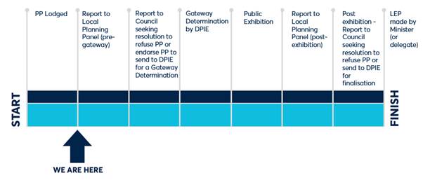
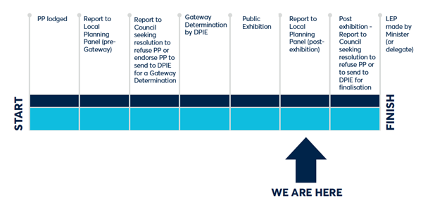
PLANNING PROPOSAL TIMELINE
SUMMARY
1. Council previously had required the developer of this site to deliver to Council a community facility as part of the redevelopment of the site that was formerly owned by Council. Development consent was granted for the building currently under construction which included a community facility in the building podium (the facility was to be a Discovery Centre) which encroached into the RE1 Public Recreation zone, as this use is permitted in the zone.
2. Council subsequently made a decision to not progress with the Discovery Centre in this location and to sell the floor-space to the developer, who agreed to purchase it and use it for commercial purposes. This decision has resulted in a zoning anomaly as the portion of the building podium that encroaches into the RE1 Public Recreation zone will no longer be used as a public facility and the commercial use proposed by the applicant is not permitted in this part of the building under the current zoning. The developer has lodged a Planning Proposal to seek to resolve the issues arising from the encroachment.
3. The encroachment is recommended to be resolved by:
· Zoning the land where the building encroaches to part B4 Mixed Use and part RE2 Private Recreation;
· Rezoning another triangular portion of land from B4 Mixed Use to RE1 Public Recreation to compensate for the loss of RE1 Public Recreation area; and
· Adjusting the floor-space ratio maps so there is no increase in development potential for the site.
4. The key justification for the approach taken is that while there is a decrease in the amount of zoned RE1 Public Recreation space (net decrease by 220 square metres) the amount of publicly available open space along the river foreshore (secured by public rights of access) remains the same as there are pedestrian walkways incorporated into the development. There is no net loss of publicly available space along the Parramatta River foreshore as a result of this Planning Proposal, and therefore the proposal to rectify the zoning anomaly described above will have minimal impact on the availability of space along the river foreshore to the public.
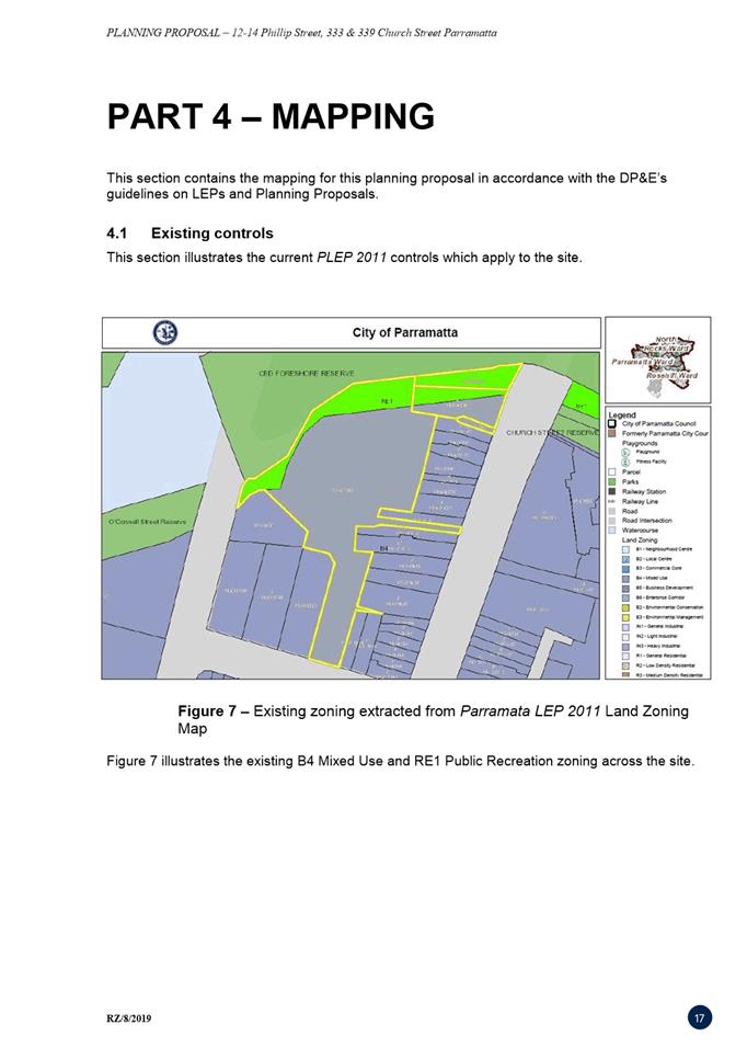
SITE DESCRIPTION
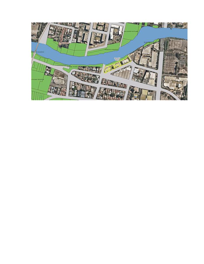
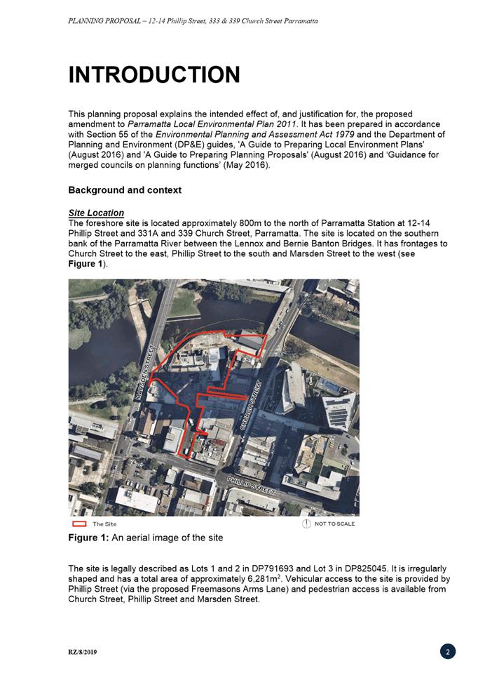
5. The subject site is at 12-14 Phillip Street and 331A, 333 & 339 Church Street, Parramatta. The site is irregularly shaped and has an area of approximately 6,281 square metres (Refer to Figure 1).
6. The site is located on the southern bank of the Parramatta River between the Lennox and Bernie Banton Bridges. Vehicular access to the site is via Phillip Street and pedestrian access is available from Church Street to the east, Phillip Street to the south and Marsden Street to the west.
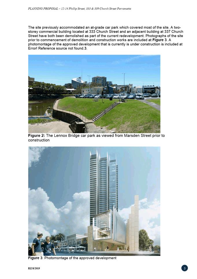
7. The site previously accommodated a Council-operated at-grade car park and two-storey commercial buildings at 331A, 333 & 339 Church Street.
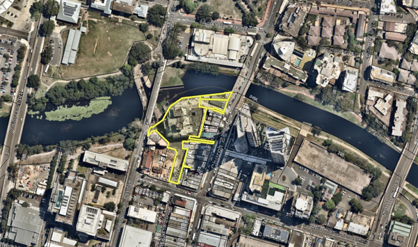
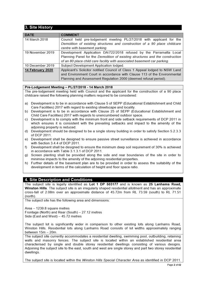
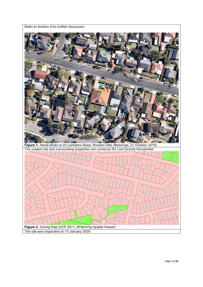
Figure 1: An aerial image of the site and surrounds (subject site outlined in yellow).
BACKGROUND
8. In November 2011, Council issued a Request for Proposals for development on the Council-owned car park site which would deliver:
· At least 24,000 square metres of residential gross floor area with an emphasis on interfaces with and activation of the Parramatta River foreshore; and
· Public infrastructure including a community facility, multi-function space, associated retail and public domain improvements.
9. Following an extensive selection process involving the review of several master plan concept designs a Project Delivery Agreement (PDA) was formally executed on 24 December 2012 between Council and PCCDevCo1 Pty Ltd (the developer) which allows PCCDevCo1 Pty Ltd to redevelop the site. Under this arrangement, the stratum subdivision would give ownership of the residential tower and commercial podium to the developer, while the community facilities and public domain would remain in Council’s ownership.
10. In May 2013, the applicant lodged a Planning Proposal to amend the Parramatta LEP 2011 to:
· Increase the maximum floor space ratio control from 6:1 to 12:1;
· Increase the height of buildings control from 80 metres to 150 metres;
· De-list the locally-listed heritage item at 333 Church Street, Parramatta; and
· Re-align the 12 metre height control for the Church Street frontage to match adjoining allotments.
The LEP amendment came into force in February 2015.
11. A Development Application was lodged in March 2014 for the construction of a 41 storey mixed-use building comprising a three-storey podium (retail on ground-floor, a community facility on level one and a conference centre on level two) and a 38 storey residential tower.
12. As the submitted architectural plans were informed by an extensive selection process where several design options were considered, it was considered unnecessary to undergo an additional design excellence competition. Pursuant to Clause 22B(5) of the then Parramatta City Centre LEP 2007, the then Director-General of the Department of Planning certified that the development would not need to undergo a design competition. Instead, the architectural plans were referred to a Design Review Panel for their appraisal. Following a few minor amendments to the submitted scheme, the scheme was granted ‘design excellence’.
13. Key design elements which contributed towards the granting of ‘design excellence’ by the design panel include the triple-height columns along the river foreshore boardwalk (with boardwalks at both river level and street level) and a glass ‘entry box’ which cantilevers over the river foreshore area. Both design elements are shown in Figure 2.
14. Development consent was granted by the then Joint Regional Planning Panel (JRPP) in May 2015. Since this time the consent has been modified twice. The first modification relates to the provision of two additional residential storeys in the tower and other minor design reconfigurations. The second modification relates to the amendment of a condition of consent to allow for the resequencing of requirements relating to the final public domain plans.
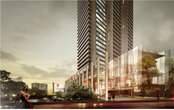
Figure 2: Key design elements viewed from Marsden Street, with the triple-height columns denoted with ‘1’ and glass ‘entry box’ denoted with ‘2’.
15. As part of the development, public access is provided across the site’s northern boundary. Public access is provided across two levels:
i. The river-level promenade, which replaces the previous foreshore level footpath and connects to the existing Lennox Bridge portals; and
ii. The street-level colonnade, which provides an at-grade connection between Church and Marsden Streets.
Figure 3 below shows the locations of the river-level promenade and street-level colonnade as per the approved plans.
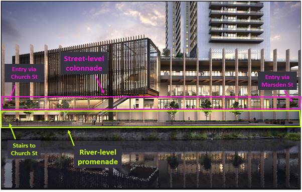
Figure 3: View of the building podium from the north (Parramatta River in the foreground).
ISSUES WITH THE CURRENT ZONING SCHEME
16. The Project Delivery Agreement required the provision of a ‘Discovery Centre’ on the site which would be retained by Council. The Discovery Centre facility was planned to integrate Council’s cultural heritage and visitor centres in the Parramatta CBD.
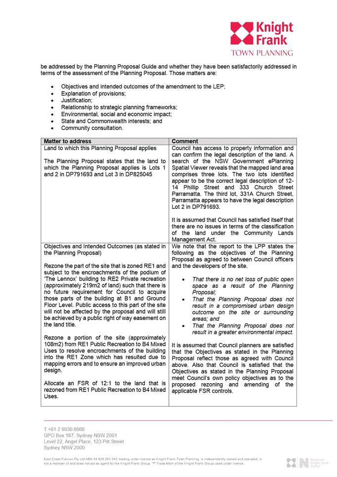
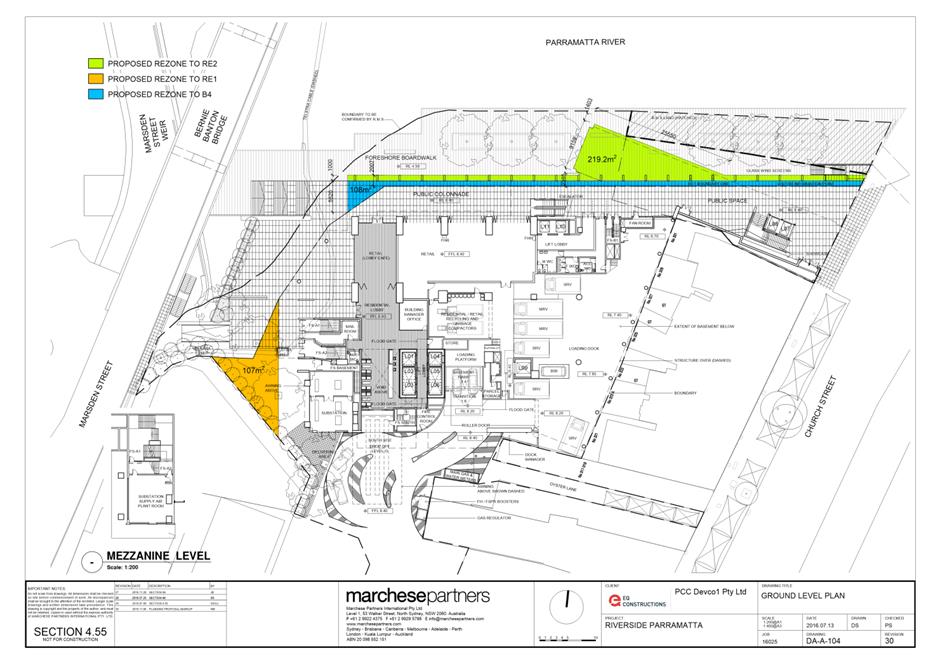
17. The approved architectural plans included the Discovery Centre and associated community facilities in one of the levels of the podium. The podium element of the building, including the glass ‘entry box’, is not wholly contained within the B4 Mixed Use zone and is approved to be partially within the RE1 Public Recreation zone. However, as the Discovery Centre is defined as an ‘information and education facility’, at the time of assessment this was a permissible use in the RE1 zone. The extent of the podium and glass ‘entry box’ approved within the RE1 zone is shown in green in Figure 4 below.
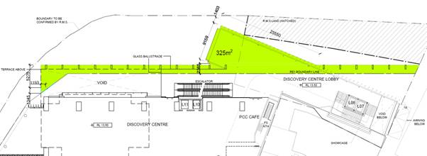
Figure 4: Extent of the podium and glass ‘entry box’ approved in the RE1 zone (in green).
18. At its meeting on 10 July 2017, Council resolved to consolidate the Discovery Centre with two other existing and one proposed cultural facilities into a larger amalgamated facility at 5 Parramatta Square. Council outlined that the facilities would be more accessible at the alternative location due to the proximity to the Parramatta Transport Interchange node, and that the cost of operating an amalgamated facility would be much less than the combined cost of operating several separate facilities.
19. As a result of the above, Council no longer requires the community space approved within the development. Following negotiations with the developer, an agreement was reached whereby the developer would purchase level one of the development which was to house the Discovery Centre. The developer is seeking to pursue commercial uses on this level.
20. Following Council’s decision to sell its interests in the site, there is a misalignment between the uses proposed by the applicant and current land zoning arrangements. The commercial use proposed by the applicant for level one is not permitted in the portion of the approved building (as shown in Figure 4) that projects into the RE1 Public Recreation zone.
21. The development of this site is already underway. An approval has been granted which cannot be revoked by Council. Construction of the building has already commenced and it is not practical to substantially amend the approved plans so that the building is no longer encroaching into the RE1 Public Recreation land. Given this there are two problems that arise from this inconsistency that need to be addressed:
i. The developer is only able to use the portions of the building encroaching into the RE1 Pubic Recreation area for uses permitted in this zone. In practical terms this limits the use of these parts of the building to Cafes which are permitted in the zone;
ii. If the RE1 Public Recreation area shown in Figure 4 is retained, Department of Planning guidelines (per LEP Practice Note 07-001) require that all land reserved for a public purpose but not acquired by a Government Agency is to be identified on the Land Reservations and Acquisition Map. Given that Council has just agreed to sell this land to the applicant, it is not appropriate for Council’s planning policy to be set up to require future reacquisition of this strip of land. Further to this, terms within the Land Acquisition (Just Terms Compensation) Act 1991 could require Council to compulsorily acquire parts of the building zoned RE1 if the landowner suffers hardship.
22. As part of the agreement to sell former Discovery Centre space, the developer is required to lodge a Planning Proposal application to seek to resolve the zoning misalignment. This report describes and provides an assessment the Planning Proposal lodged by the developer.
PLANNING PROPOSAL ASSESSMENT
23. Council Officers have discussed options with the applicant on how the zoning misalignment might be resolved and agreed that any resolution should achieve the following objectives:
i. That there is no net loss of public open space as a result of the Planning Proposal;
ii. That the Planning Proposal does not result in a compromised urban design outcome on the site or surrounding areas; and
iii. That the Planning Proposal does not result in a greater environmental impact.
24. The applicant lodged their initial Planning Proposal on 11 October 2019. The Planning Proposal, as first submitted, sought to amend the Parramatta LEP 2011 to change the zoning as indicated in Figure 6 including:
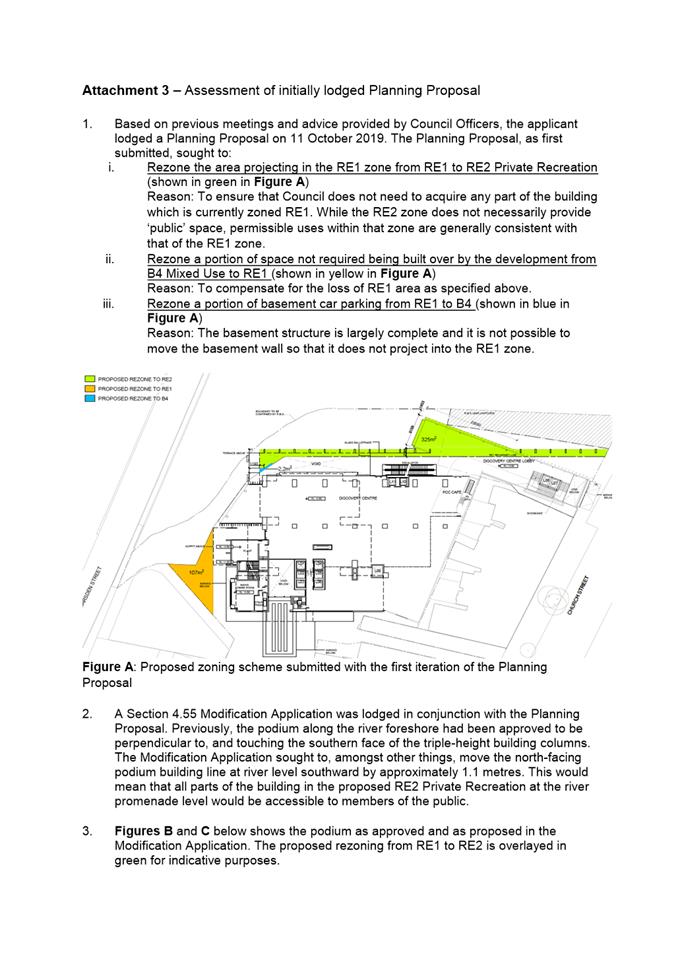
i. Rezoning the area projecting in the RE1 zone from RE1 to RE2 Private Recreation;
ii. Rezoning a portion of space not required being built over by the development from B4 Mixed Use to RE1;
iii. Rezoning a portion of basement car parking from RE1 to B4; and
iv. Making relevant adjustments to the FSR maps in the areas to be rezoned.
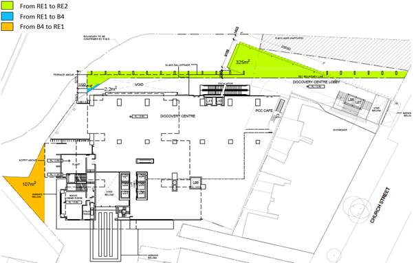
Figure 6: Proposed zoning scheme submitted with the initial Planning Proposal.
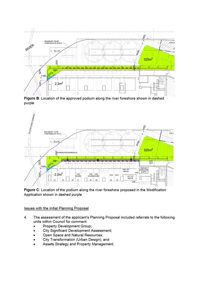
25. An application to amend the current approved Development Application was lodged with the Planning Proposal. As shown overleaf in Figure 8 the application was seeking to move the podium wall fronting the river so that the entire area to be rezoned from RE1 Public Recreation to RE2 Private Recreation was able to be accessed by members of the public via a public right of access easement. Given the area of ‘publicly zoned land’ was being reduced, the amount of land accessible to the community would still be maximised via the public right of way and by moving the wall.
26. However, the assessment identified that this arrangement created an unsafe space behind the columns creating a public safety risk. A better urban design outcome can be achieved if the approved podium wall at river level abutting the rear of the triple height columns is retained, and that spaces, publicly accessible or otherwise, not be created behind the columns. A comparison of both arrangements is shown in Figure 7 overleaf.
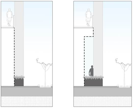
Figure 7: Location of the approved podium wall fronting the river (left)
Initially proposed modification of the podium wall fronting the river (right)
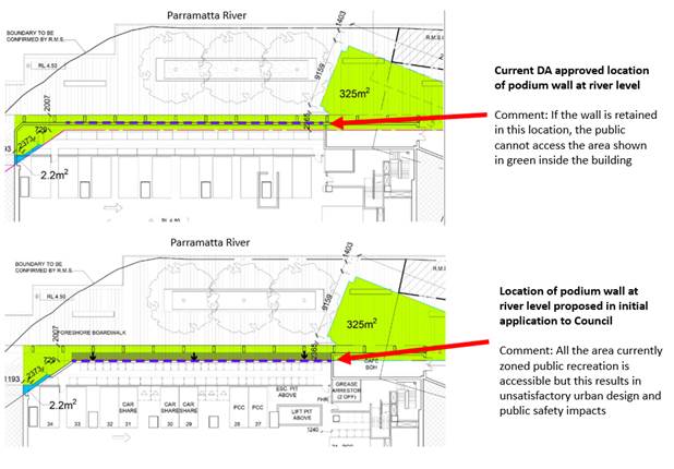
Figure 8: Location of the podium wall as approved and as proposed in the initial application
Table 1: The initial Planning Proposal’s consistency with Council Officer’s objectives
|
Objective |
There is no net loss of public open space as a result of the Planning Proposal |
The Planning Proposal does not result in a compromised urban design outcome on the site or surrounding areas |
That the Planning Proposal does not result in a greater environmental impact |
|
Compliance |
ü |
û |
ü |
|
Discussion |
There is marginal gain of accessible space as a result of the Planning Proposal given the proposal to provide access to RE2 zoned land via the public right of way. However, this space is of low amenity. |
The Planning Proposal facilitates a modification application which results in a building interface with deep recessed elements which created CPTED issues. |
The Planning Proposal has a neutral environmental impact. |
27. The urban design issues mean that an alternate approach is being recommended by Council Officers which is described in detail in the next section of this report. A more detailed assessment of the initially lodged Planning Proposal is provided at Attachment 3.
RECOMMENDED PLANNING PROPOSAL
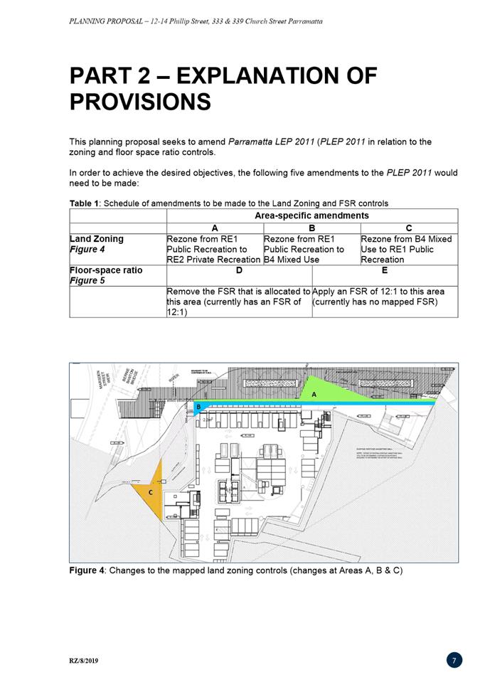
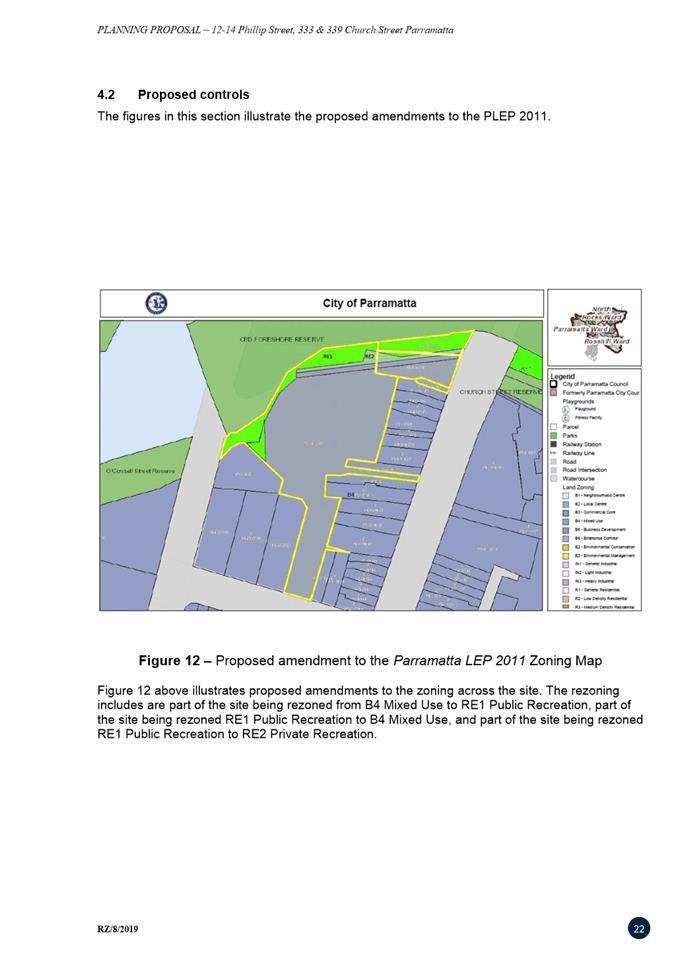
28. The applicant amended their Planning Proposal in accordance with the advice provided by Council Officers. The revised Planning Proposal seeks to amend the Parramatta LEP 2011 to make the changes proposed in Figure 9 which includes:
i. Rezone the part of the building that encroaches into the RE1 zone, (the strip south of columns), from RE1 Open Space to B4 Mixed Use
Reason: To recognise that amending the building to allow public access at the river level boardwalk level results in unacceptable urban design and safety outcomes. This will allow the applicant to use this strip which forms part of the building for a commercial use which will allow for the most efficient use of this part of the approved building.
It should also be noted that there is an upper level boardwalk (on the same level as Church Street) that sits above the land to be zoned B4 Mixed Use on the lower level boardwalk (on the same level as the Parramatta River). The upper level boardwalk will have a public right of way easement, as required as part of the PDA, that will allow the public access over the strip of land, irrespective of the area being zoned RE1 Public Recreation or B4 Mixed Use. The appropriate zoning for this strip of land shown in Figure 9 is B4 Mixed use as it is located within the mixed use building at the riverside boardwalk level.
ii. Rezone the outermost area projecting in the RE1 Public Recreation zone to the north-face of the columns from RE1 Public Recreation to RE2 Private Recreation
Reason: To ensure that Council does not need to acquire any part of the building which is currently zoned RE1 Public Recreation while minimising the total amount of area to be rezoned B4 Mixed Use. Access will still be retained at the upper level boardwalk in this area via a public right of access.
iii. Rezone a portion of space not required being built over by the development from B4 Mixed Use to RE1 Public Recreation (shown in yellow in Figure 9)
Reason: To compensate for the loss of RE1 Public Recreation area as specified above.
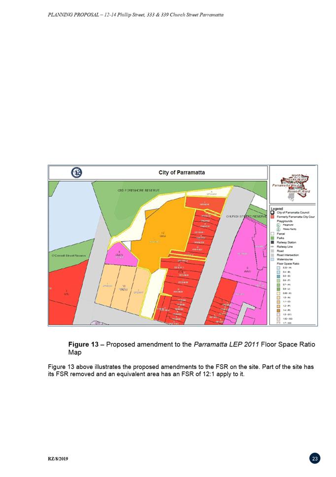
iv. Make relevant adjustments to the floor-space ratio maps in the areas to be rezoned
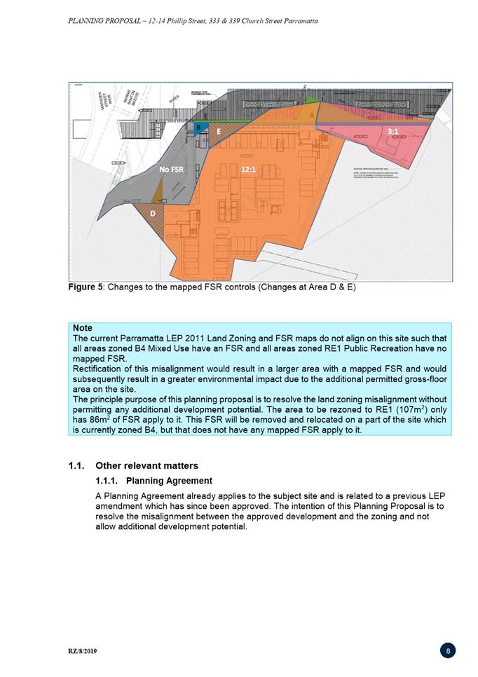
Reason: The rezoning of part of the site from RE1 Public Recreation to B4 Mixed Use could permit additional gross-floor area on the site if the current floor-space ratio arrangements are maintained. It is noted that the current land use zoning and floor-space ratio maps do not align and that only 68 square metres of the part of the site being rezoned from B4 Mixed Use to RE1 Public Recreation, which totals 107 square metres, has floor-space apply to it. To not allow for any additional development potential the area to be rezoned to B4 Mixed Use (108 square metres) will have its floor-space ratio amended so that a floor-space ratio control of 12:1 applies to only 68 square metres of the rezoned area. The area to be rezoned to RE1 Public Recreation will have its floor-space ratio of 12:1 removed so that no control applies. No amendment to the mapped floor-space ratio control is required for the part of the site being rezoned RE1 Public Recreation to RE2 Private Recreation (retain no floor-space ratio control).
29. The proposed zoning scheme overlaid on the approved architectural plans is shown in Figure 9 below. A complete set of indicative zoning plans, as proposed in the revised Planning Proposal are provided at Attachment 4.
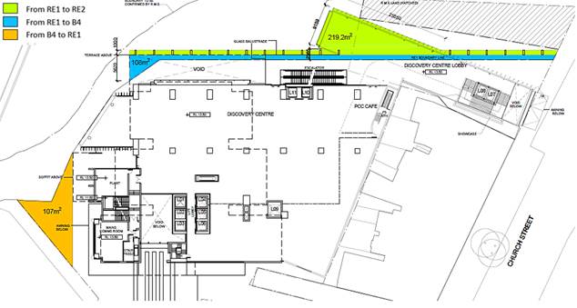
Figure 9: Proposed amendments to the land use zoning map
Justification
30. While the Planning Proposal reduces the amount of RE1 Public Recreation zoned land on the site, it does not reduce the amount of publicly accessible open space. The approved development facilitates more public open space than what could be provided under strict adherence to land use zoning as it includes publicly accessible spaces across multiple levels and in RE1, B4 and W2 zones. The quantum of publicly accessible space will not change as a result of the Planning Proposal – only the zoning of the publicly accessible areas will be subject to change. This is demonstrated in Table 2.
Table 2: Comparison of the quantum of public open space under different zoning schemes
|
|
Current Zoning |
Initial Planning Proposal & Modification Application |
Recommended Planning Proposal |
|
Land zoned RE1 |
1,569m2 |
1,349 m2 |
1,349 m2 |
|
Publicly accessible area in RE1 zone* |
2,544m2 |
1,998m2 |
1,998m2 |
|
Publicly accessible area in RE2 zone |
nil |
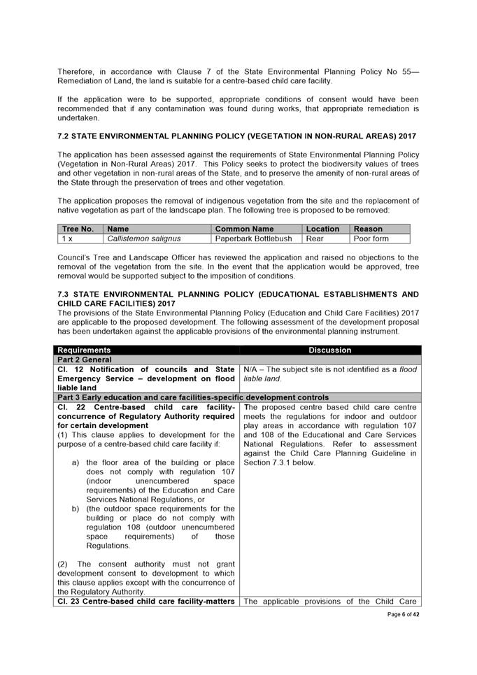
614m2 |
438m2 |
|
Publicly accessible area in B4 zone |
746m2 |
746m2 |
854m2 |
|
Publicly accessible area in W2 zone |
630m2 |
630m2 |
630m2 |
|
Total Public Open Space |
3,920m2 |
3,988m2 |
3,920m2 |
Note: The public access to the site via Freemasons Arms Lane and Oyster Lane has not been included in the above calculations. These easements and their associated zoning are not subject to change as a result of any Planning Proposal or Modification Application.
*Publicly accessible area in the RE1 zone is provided on the river-level promenade and above on the street-level colonnade, hence why it is higher than the actual land zoned RE1.
31. Council Officers acknowledge that the triangular shaped area to be rezoned from B4 Mixed Use to RE1 Public Recreation is unlikely to be high-quality public open space due to its location away from the Parramatta River. The area would be capable of providing trees and a resting area (benches, tables, etc.) for people walking along the river foreshore. However, irrespective of this Planning Proposal, arrangements in the Project Delivery Agreement have this area dedicated to Council, with public access arrangements to be applied at subdivision stage. Given this, the rezoning of this area to RE1 is justified as it aligns with its proposed uses and helps minimise the net loss of zoned RE1 Public Recreation area.
32. It is noted that areas of the site zoned RE1 Public Recreation are classified as operational land. The Planning Proposal does not intend to make any amendments to the classification of land on this site and any new RE1 Public Recreation areas will also be operational land.
33. The area to be rezoned to B4 Mixed Use (108 square metres) will have its floor-space ratio amended so that a floor-space ratio control of 12:1 applies to the 68 square metres of the rezoned area. However, in order to ensure that the Planning Proposal does not result in a greater environmental impact than what is already approved, the area to be rezoned to RE1 Public Recreation will have all of its floor-space ratio of 12:1 removed (68 square metres) so that no control applies. This is to ensure that no additional gross-floor area can be generated as a result of this Planning Proposal. The intention of this Planning Proposal is to resolve the misalignment between the approved development and the zoning and not allow additional development potential.
34. Council Officers considered amending the floor-space ratio maps so that the existing misalignment between zoning and floor-space ratio maps is rectified (so that floor-space ratio applies to all areas zoned B4 Mixed Use and so no floor-space ratio applies to areas zoned RE1 Public Recreation and RE2 Private Recreation). However, the area zoned B4 Mixed Use is larger than the area which has a mapped floor-space ratio. Aligning the zoning and floor-space ratio maps would result in a significant increase in development potential which would not align with the objectives of the Planning Proposal.
35. The revised Planning Proposal aligns with all of the Council Officer’s objectives, as summarised in the assessment matrix in Table 3.
Table 3: The revised Planning Proposal’s consistency with Council Officer’s objectives
|
Objective |
There is no net loss of publicly accessible usable space as a result of the Planning Proposal |
The Planning Proposal does not result in a compromised urban design outcome on the site or surrounding areas |
That the Planning Proposal does not result in a greater environmental impact |
|
Compliance |
ü |
ü |
ü |
|
Discussion |
Whilst there is a nominal decrease in the area of zoned open space, the amount of publically available open space protected via public right of ways over the riverside boardwalk and higher terrace means the amount of space available to the community is unchanged. |
The Planning Proposal allows for an appropriate building interface with the public domain at river-level in accordance with the original design excellence scheme. |
The Planning Proposal has a neutral environmental impact as no additional gross floor area can be derived as a result of the rezoning. |
PEER REVIEW
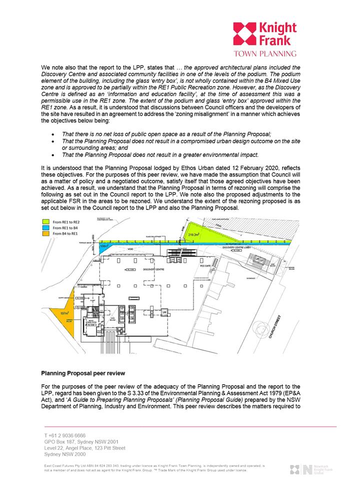
36. As Council has formally had an interest in this site, Council Officers have commissioned an independent peer review of this report and the Planning Proposal document.
37. Following an internal tender selection process, Knight Frank Town Planning was selected to complete the peer review for Council. The consultancy was appropriately briefed on the background to the Planning Proposal and was provided all relevant material to assist them with providing professional planning advice.
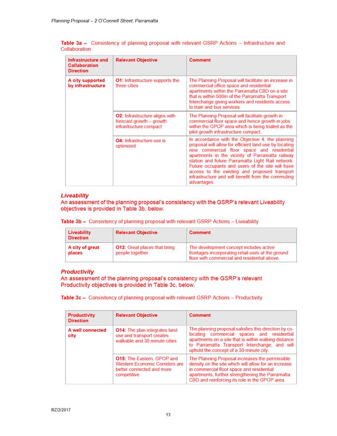
38. On 27 March 2020, Knight Frank issued their peer review to Council Officers. The peer review acknowledged the need for the Planning Proposal and gave in-principle support for the amendments to the mapped land use zoning and floor-space ratio controls as a means to rectify the misalignment between the approved development and the zoning.
39. The independent peer review suggested minor technical amendments to the Planning Proposal document and these have been adopted in their entirety. The complete independent peer review can be found at Attachment 1.
40. Based on this peer review, Council Officers are satisfied that the Planning Proposal has been assessed transparently and can be forwarded to the Department of Planning, Industry and Environment for a Gateway Determination.
PLAN-MAKING DELEGATIONS
41. New delegations were announced by the then-Minister for Planning and Infrastructure in October 2012, allowing councils to make LEP amendments of local significance. On 26 November 2012, Council resolved to accept the delegation for plan-making functions and that these functions be delegated to the Chief Executive Officer.
42. It is noted that Council has previously had an interest in this site. In order to avoid a perceived conflict of interest, Council Officers have recommended that Council not request plan-making delegations for this Planning Proposal. This means that once the Planning Proposal has been to Gateway, undergone public exhibition and been adopted by Council, the Department, rather than Council Officers, will liaise with Parliamentary Counsel Office on the legal drafting and mapping of the LEP amendment. The Minister of Planning (or delegate) then signs the LEP amendment before it is notified on the NSW Legislation website.
CONSULTATION & TIMING
43. Council Officers have met with officers from the Department of Planning, Industry and Environment to seek their preliminary advice on the approach used to resolve the planning issues related to this site. The Department’s Officers understood the rationale underpinning the Planning Proposal and advised that they are willing to consider the argument being put forward by Council Officers.
44. Council Officers acknowledge that this advice was provided in good faith and does not constitute an approval. Furthermore, the assessment contained within this report, together with the Planning Proposal and supporting documentation, will need to be assessed by the Department which will then determine whether the Planning Proposal can proceed via a Gateway Determination.
45. Should a Gateway Determination be issued by the Department, the Planning Proposal will be publicly exhibited for a minimum of 28 days. A report on the outcomes of the public exhibition will be provided to the Local Planning Panel addressing any objections received. If no objections are received, the matter will be reported directly to Council seeking approval to finalise the Planning Proposal.
FINANCIAL IMPLICATION FOR COUNCIL
46. The independent peer review has been paid for using funds from Council’s Land Use Planning budget that includes funds received annually to fund third-party consultants that assists Council with either making or implementing planning decisions in a transparent manner. The total costs associated with the peer review are in the order of $3,000.
47. This Planning Proposal does not result in any additional residential uplift. Council Officers are not seeking to negotiate an associated Planning Agreement on this basis. This proposal deals with the issues arising from a Council decision to sell the floor space that would have been occupied by former Discovery Centre facility to the developer. The financial impact of the decision to sell the facility was considered at Council’s meeting on 28 August 2019 in closed session and is not relevant to this part of the process which seeks to resolve the planning issues arising from that decision.
Marko Rubcic
Project Officer, Land Use Planning
Robert Cologna
Team Leader Land Use Planning
David Birds
Group Manager, City Planning
Jennifer Concato
Executive Director City Strategy & Development
|
1⇩ |
Final peer review |
7 Pages |
|
|
2⇩ |
Planning Proposal |
30 Pages |
|
|
3⇩ |
Assessment of initially lodged Planning Proposal |
4 Pages |
|
|
4⇩ |
Mapped zoning amendments |
14 Pages |
|
ITEM NUMBER 6.2
SUBJECT Post Exhibition Outcome - Planning Proposal, draft site-specific Development Control Plan and draft Planning Agreement for 2 O'Connell Street, Parramatta
REFERENCE RZ/2/2017 - D07333909
REPORT OF Project Officer-Land Use Planning
|
LAND OWNER The Owners of Strata Plan 20716
APPLICANT Think Planners
PURPOSE:
To seek the Local Planning Panel’s advice on the outcome of the public exhibition of the Planning Proposal, draft site-specific Development Control Plan and draft Planning Agreement for land at 2 O’Connell Street, Parramatta for Council’s consideration.
|
|
That the Local Planning Panel consider the following Council staff recommendation in its advice to Council:
(a) That Council receives and notes the submissions made during the public exhibition of the Planning Proposal, draft site-specific Development Control Plan (DCP) and draft Planning Agreement.
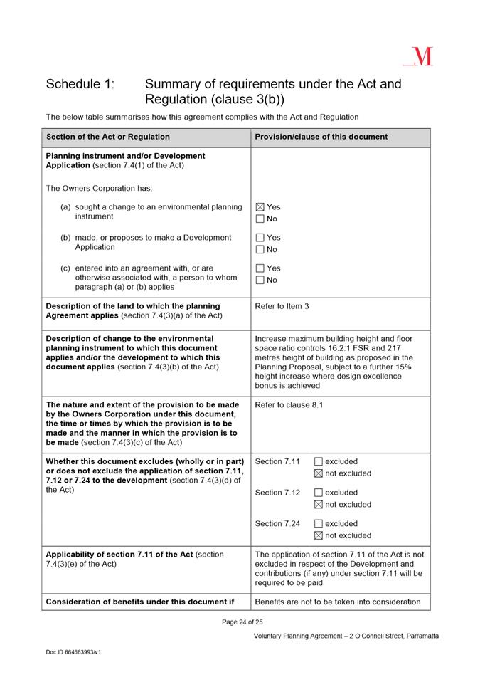
(b) That Council endorse for finalisation the Planning Proposal provided at Attachment 1, which seeks to amend the Parramatta LEP 2011 as follows:
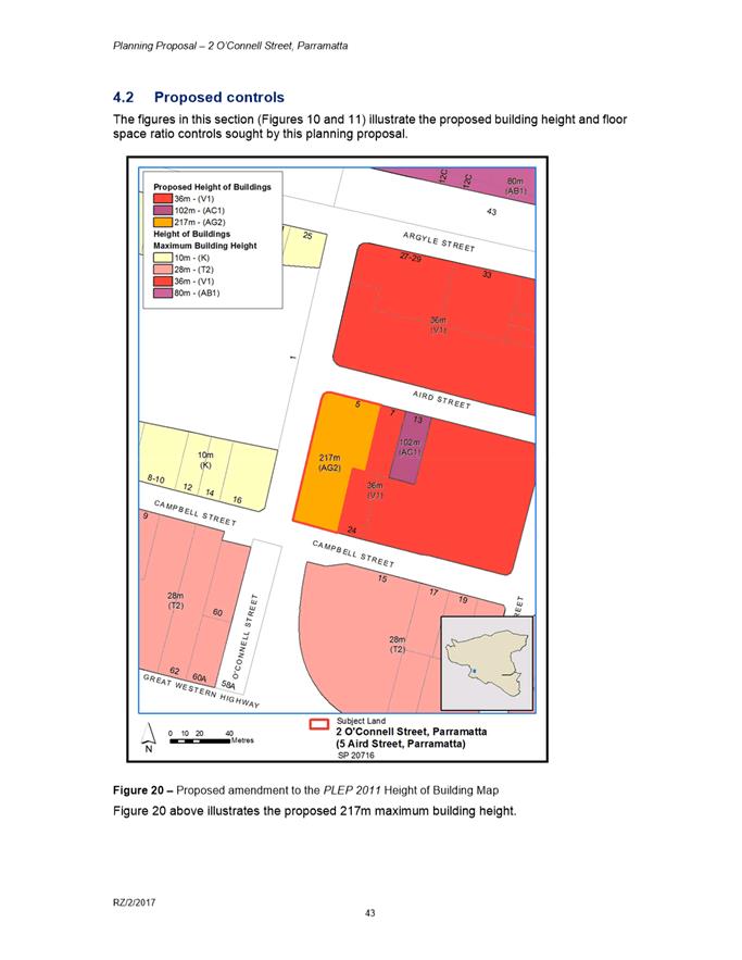
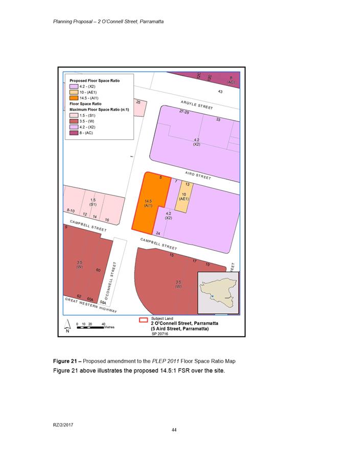
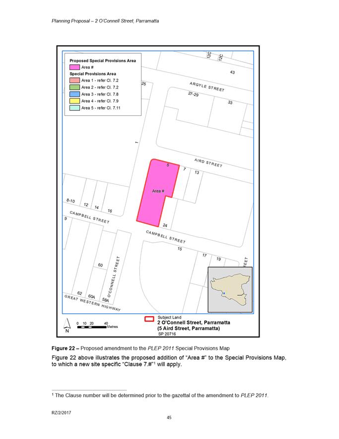
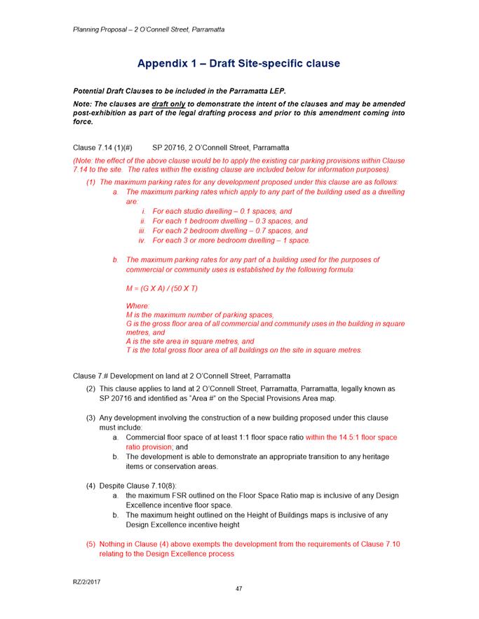
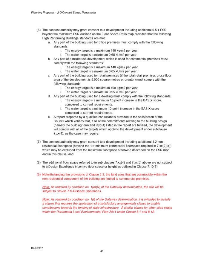
i. An increase in the maximum Height of Buildings from 36 metres to 217 metres (inclusive of design excellence bonus); ii. An increase in the maximum FSR from 4.2:1 to 16.2:1 (including all bonuses, opportunity site provisions and additional non-residential floor space); iii. Introduction of site-specific provisions that outline the requirements for achieving the maximum FSR, require an appropriate transition to heritage items or conservation areas, introduce maximum parking rates, and ensure that issues pertaining to airspace operations and satisfactory arrangements for State infrastructure are addressed.
(c) That Council forward the Planning Proposal to the Department of Planning, Industry and Environment (DPIE) to prepare for finalisation, but request the final notification on the relevant Government website only be undertaken once: i. Council confirms that the Planning Agreement has been signed and entered into; and ii. the site-specific DCP has been publicly exhibited and endorsed by Council for finalisation.
(d) That an amended DCP is re-exhibited and the outcomes of this exhibition are reported to Council. The amendments to be made to the DCP prior to re-exhibition are as follows:
i. Removal of the 3.5 metres setback to O’Connell Street (as Transport for NSW has indicated this is no longer required for road widening purposes) and resulting adjustments to relevant controls including but not limited to changes to the building and tower setbacks; ii. Addition of a section on heritage that refers to the LEP provision relating to heritage transition and impacts. The new DCP controls will ensure clear criteria for assessing the transition of any development on this site to the adjoining heritage item; and iii. Addition of a control outlining that materials selection is to minimise reflectivity and glare impacts. (e) That, with regards to the Planning Agreement:
i. That an administrative amendment is undertaken to the draft Planning Agreement provided at Attachment 4 to accurately describe the instrument change sought under the Planning Proposal (noting that this does not change the contribution or any other terms of the Planning Agreement); ii. That Council enter into this amended Planning Agreement; iii. The Chief Executive Officer be delegated authority to sign the Planning Agreement on behalf of Council; iv. Council (in accordance with its statutory obligations) forward the Planning Agreement to DPIE once it comes into force.
(f) Further, that Council authorise the Chief Executive Officer to make any minor amendments and corrections of a non-policy and administrative nature that may arise during the plan amendment process relating to the Planning Proposal, DCP and Planning Agreement.
|
THE SITE
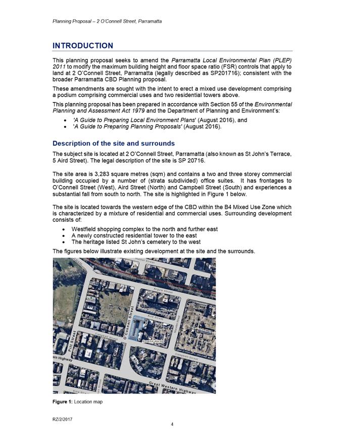
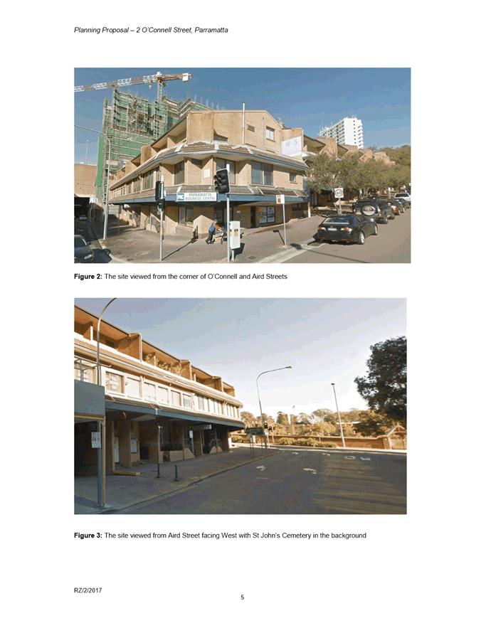
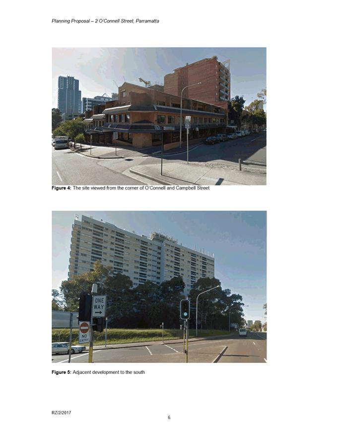
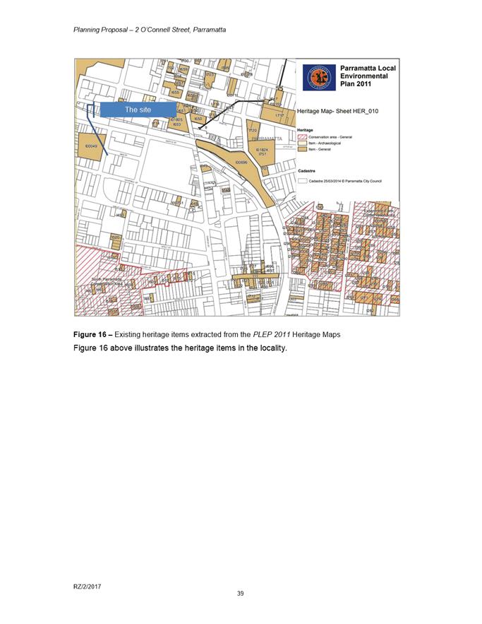
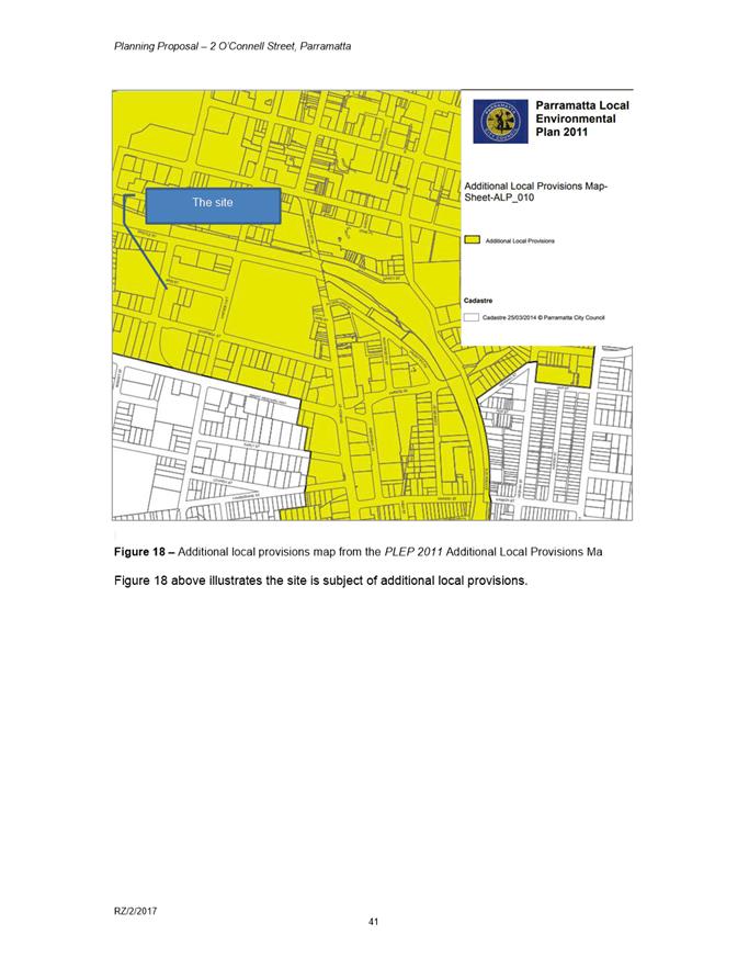
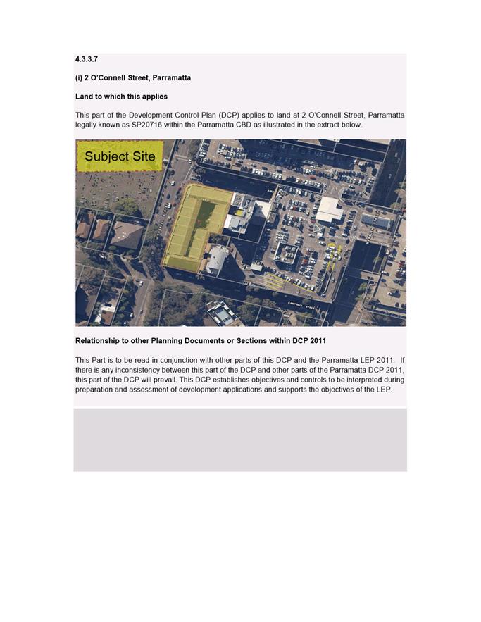
1. The subject site is located at 2 O’Connell Street, Parramatta and is also known as St John’s Terrace, 5 Aird Street. The legal description of the site is Strata Plan 20716. The site area is 3,283 square metres and contains a two and three-storey commercial building occupied by a number of strata subdivided office suites. The site has frontages to O’Connell Street (West), Aird Street (North) and Campbell Street (South) and slopes substantially from south to north. An aerial photo of the site is shown below in Figure 1.
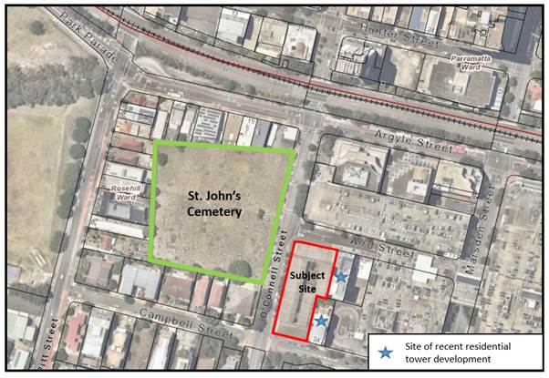
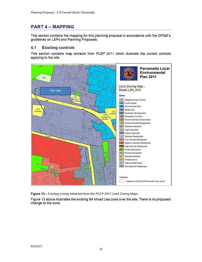
Figure 1: Site location (Source: City of Parramatta GIS)
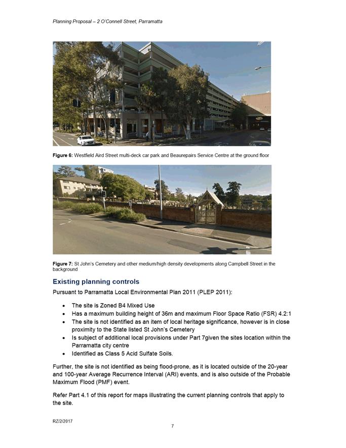
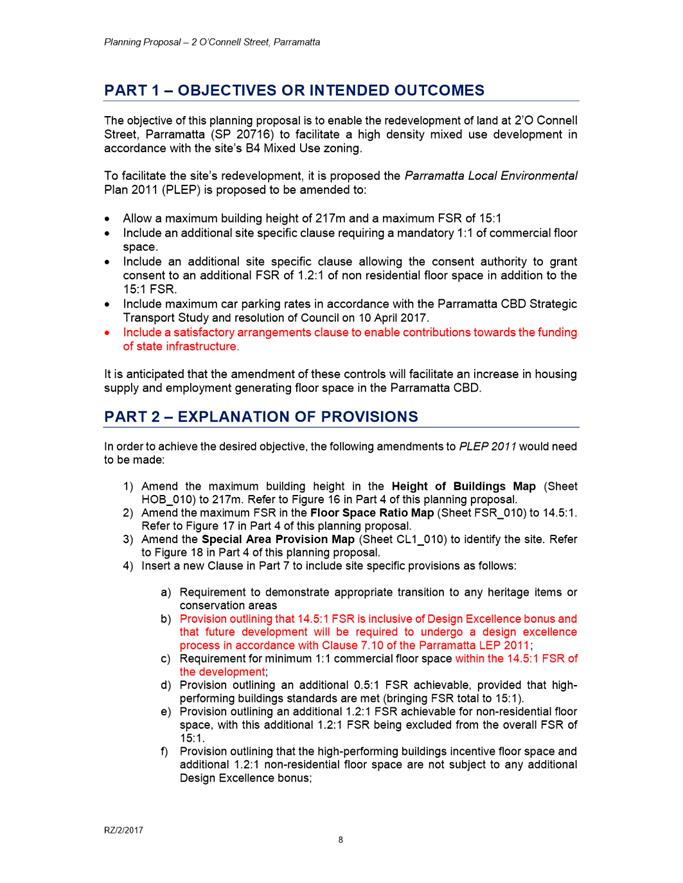
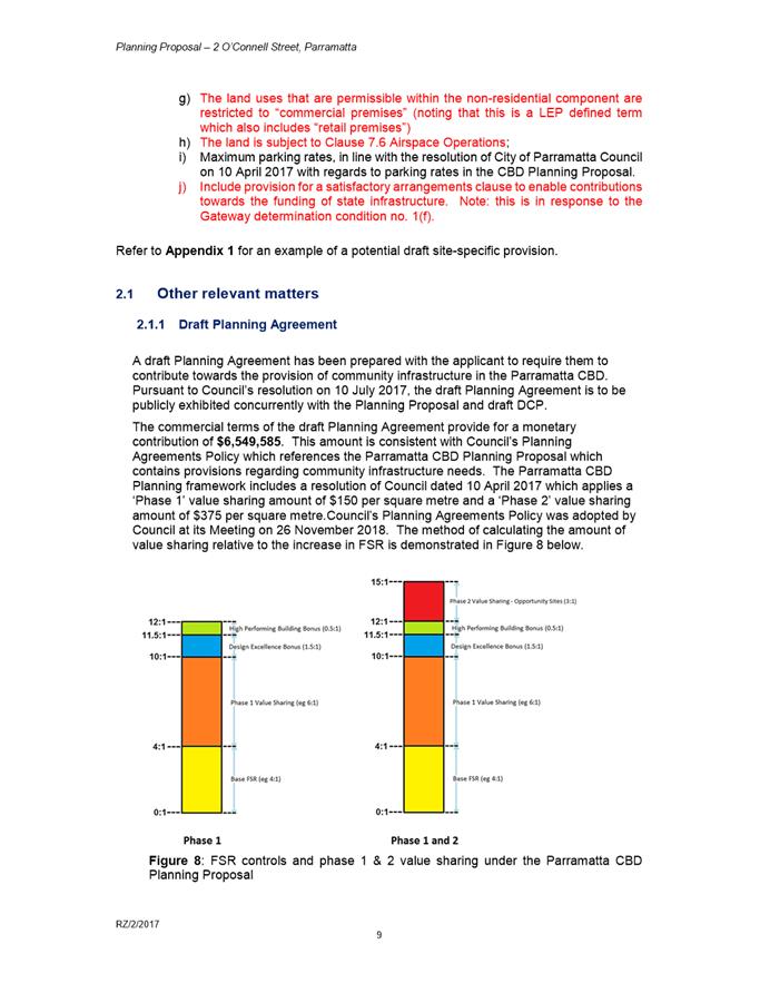
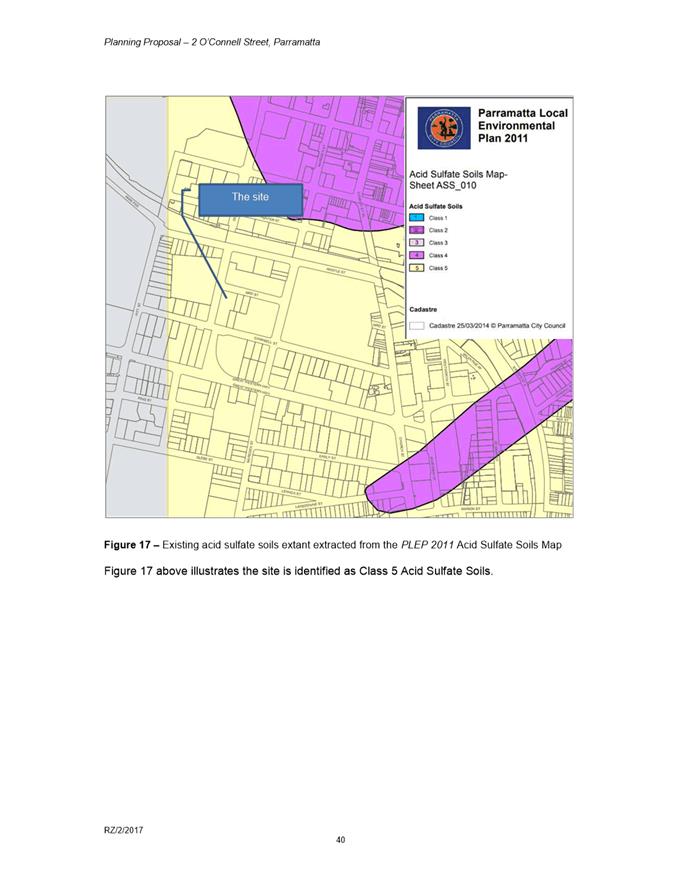
2. The site is located towards the western edge of the Parramatta CBD within the B4 Mixed Use zone, which is characterised by a mixture of residential and commercial uses. To the north of the site is the Westfield shopping complex, immediately to the east two newly-constructed residential towers, and opposite the site to the west, the State Heritage-listed St. John’s Cemetery.
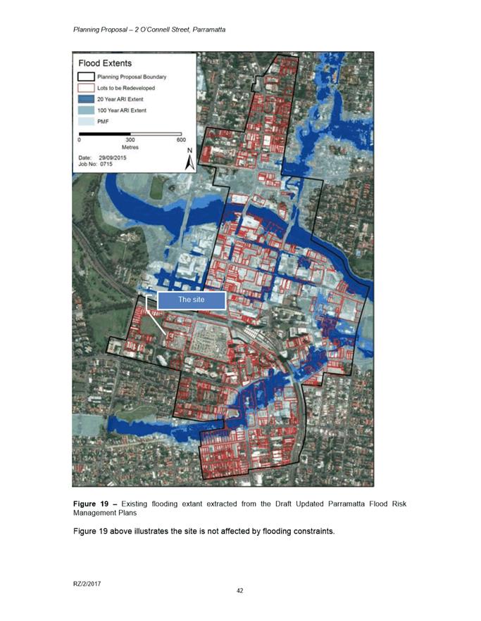
3. With regards to flooding issues, this site is outside of the area affected by the 1-in-100-year Average Recurrence Interval (ARI).
BACKGROUND
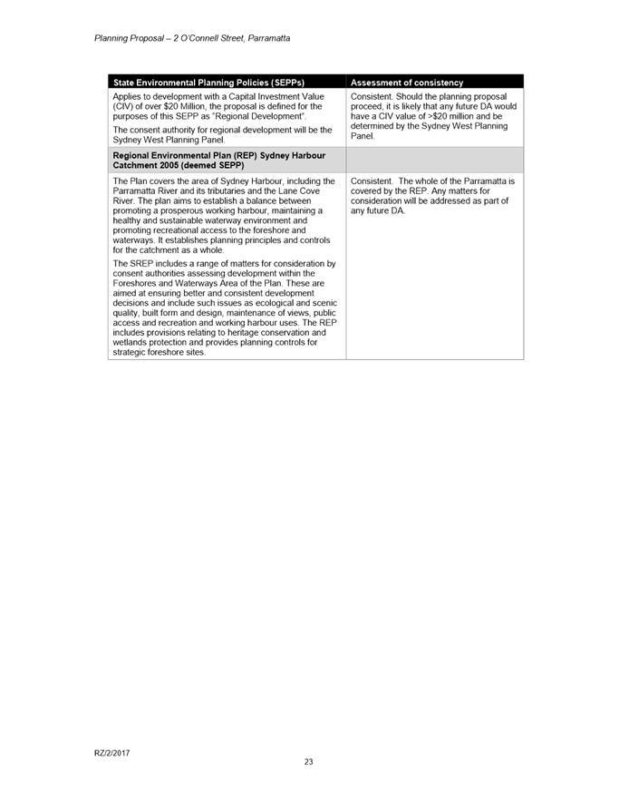
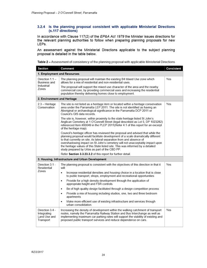
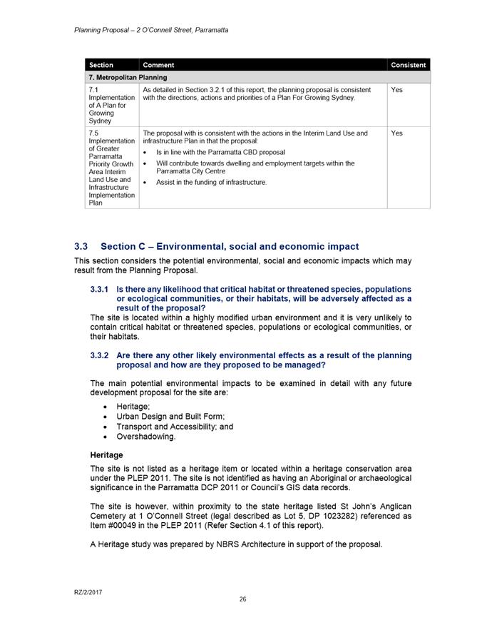
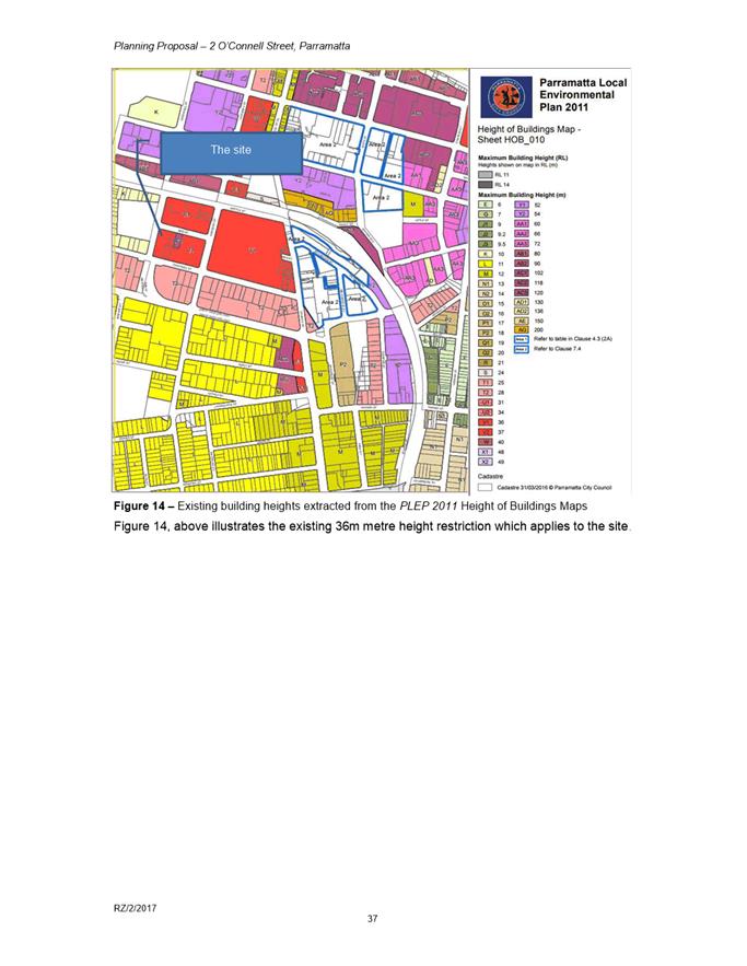
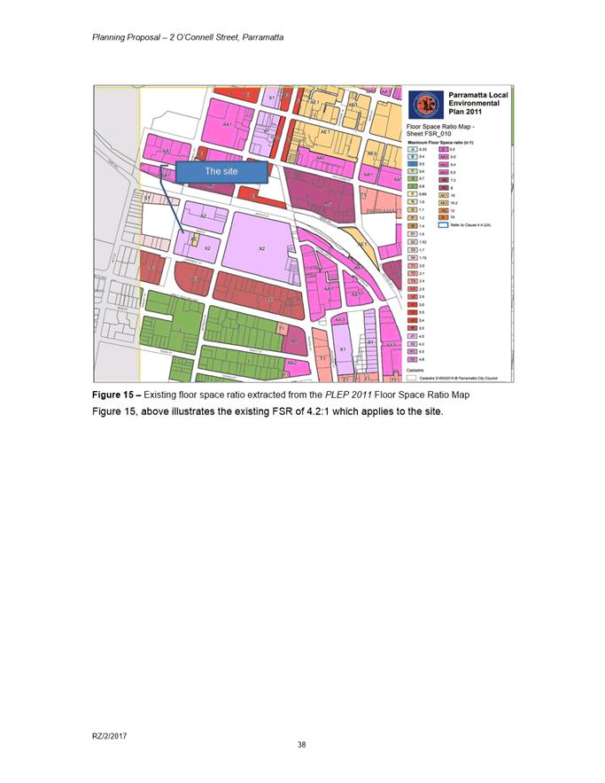
4. At its meeting on 10 July 2017, Council considered a report on a Planning Proposal for the subject site and resolved to endorse the Planning Proposal for the purposes of seeking a Gateway Determination, which seeks changes to Parramatta LEP 2011 (PLEP 2011) consistent with the Parramatta CBD Planning Proposal, as outlined in the table below.
Table 1. Comparison of controls for the subject site between Parramatta LEP 2011, the Parramatta CBD Planning Proposal, and the exhibited planning proposal
|
Parramatta LEP 2011 |
Parramatta CBD Planning Proposal |
Planning Proposal |
|
|
Zoning |
B4 Mixed Use |
B4 Mixed Use |
B4 Mixed Use |
|
Maximum HOB |
36m (approximately 10 storeys) |
RL 243m (approximately 217m when converted to height above ground level – 66 storeys) |
217m (inclusive of Design Excellence – 66 storeys) |
|
Maximum FSR |
4.2:1 |
15:1 FSR (including all bonuses) with the potential for additional non-residential FSR |
15:1 FSR (including all bonuses) + 1.2:1 additional non-residential FSR |
|
Approximate yields
|
|
3,283 m2 (mandatory 1:1 commercial, with potential for additional non-residential FSR)
575 dwellings (at 80 m2 per dwelling) |
3,283 m2 mandatory 1:1 commercial
45,962 m2 residential (14:1 residential) 575 dwellings (at 80 m2 per dwelling)
Additional 3,939 m2 additional commercial floorspace
|
5. Council also resolved on 10 July 2017 to prepare a draft Development Control Plan (DCP) and enter negotiations on a Planning Agreement, and to report both to Council for endorsement prior to their concurrent exhibition with the Planning Proposal.
6. At Council’s meeting on 26 February 2018, a further report was considered which sought to respond to advice from the then-Department of Planning and Environment (now referred to as the Department of Planning, Industry and Environment, or DPIE). DPIE’s advice was to restructure the format and mechanism of the proposed FSR controls to more closely align with the format of PLEP 2011, while still achieving development density outcomes in line with Parramatta CBD Planning Proposal (as were previously endorsed by Council). In response to this report, Council resolved to restructure the Planning Proposal in accordance with DPIE’s advice, and also resolved to consider a further report on the heritage impacts of the Planning Proposal on St. John’s Cemetery.
7. Council considered the further report on 9 April 2018. Council resolved to endorse the Planning Proposal without changes and also included the following additional resolutions:
i. That the public domain landscaping on the eastern side of O’Connell Street is enhanced. (This is achieved within the draft DCP through controls to require retention of existing trees and provision of new street trees.)
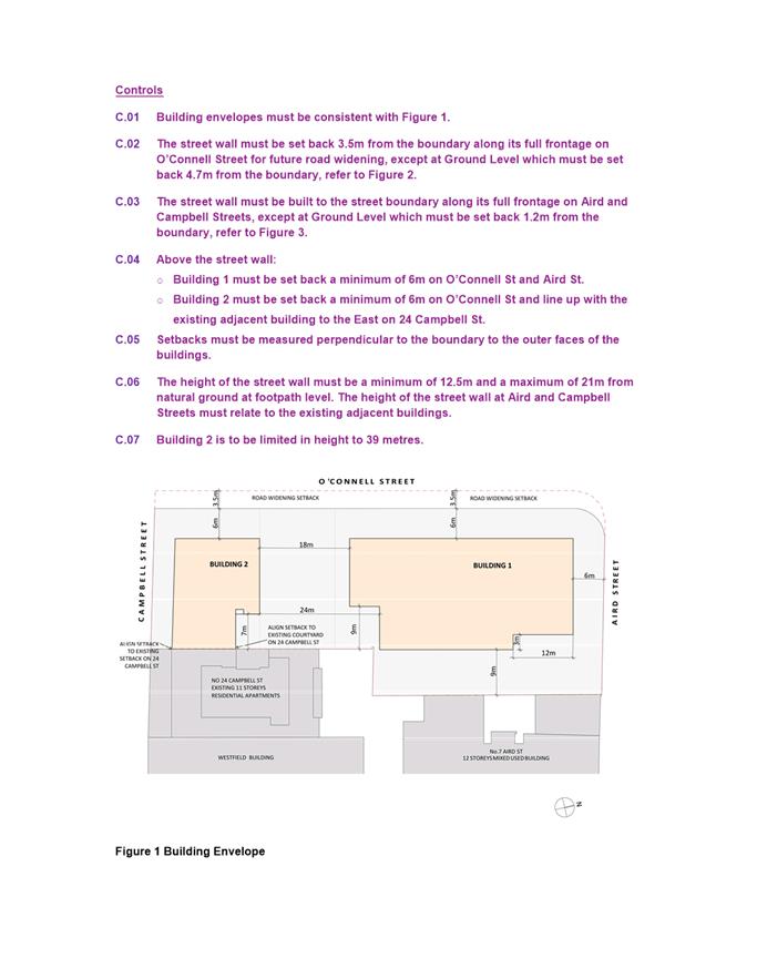
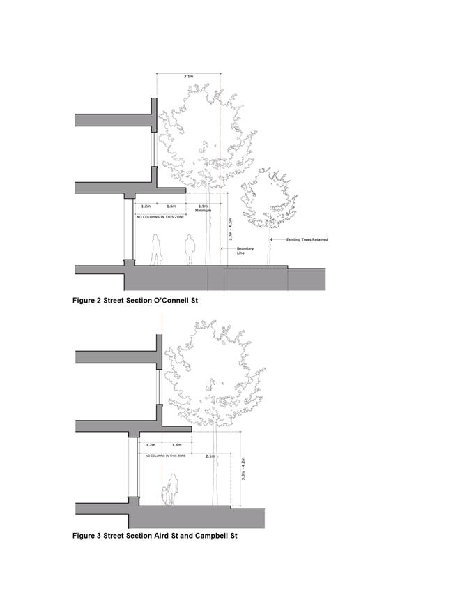
ii. That the northern edge of the new development to Aird Street considers the existing axial views from the cemetery path. (This is interpreted within the draft DCP to provide for the protection of the view corridor along Aird Street when looking east from the cemetery entrance gates, and is achieved through the setback controls from Aird Street which provide for a 6 metre tower setback and a 1.2 metre ground level setback).
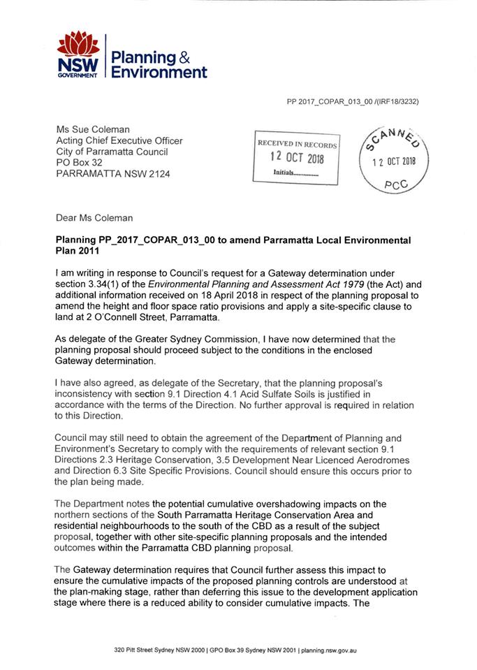
Gateway Determination
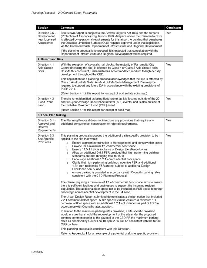
8. DPIE issued a Gateway determination on 5 October 2018 (refer to Attachment 2). The Gateway determination required that certain amendments were made to the Planning Proposal, and that an amended Planning Proposal be sent back to DPIE for their endorsement prior to exhibition. The main Gateway conditions are outlined below, along with a comment as to how these conditions were addressed by Council officers:
i. Assess the cumulative overshadowing on the South Parramatta and Harris Park West Heritage Conservation Areas (HCAs).
Comment: An analysis of cumulative overshadowing issues on the South Parramatta and Harris Park West HCAs was completed as part of work on the Parramatta CBD Planning Proposal. The overshadowing impact from this particular site-specific Planning Proposal on these areas was found to be negligible and therefore no change to the Planning Proposal was recommended as a result.
ii. Address the comments by the Roads and Maritime Services (RMS) (dated 13 February 2018).
Comment: The exhibited reference design was revised to reflect the 3.5 metre road widening required by the RMS.
iii. Update the Urban Design Study to reflect an FSR of 16.2:1 and a 3.5 metre road-widening on O’Connell Street.
Comment: The exhibited reference design had an FSR of 16:1 and the 3.5 metre road widening. As explained later in this report, due to TfNSW advice that the 3.5 metre road widening is not required, the applicant has now confirmed a revised reference design with FSR of 16.2:1.
iv. Update the “Explanation of provisions” within the Planning Proposal document to reflect the revised structure of the FSR calculation.
Comment: The Planning Proposal document was updated to reflect this structure.
v. Include a satisfactory arrangements clause to enable contributions towards the funding of State infrastructure.
Comment: The Planning Proposal document was amended to include this provision.
vi. Consult with federal Department of Infrastructure, Transport, Cities and Regional Development (DIRD) prior to exhibition.
Comment: Council consulted with DIRD and subsequently received a response from DIRD and from Sydney Metro Airports.
In summary, DIRD advised that the development may require approval under the Airports (Protection of Airspace) Regulations 1996, including assessment by the Civil Aviation Safety Authority and Airservices Australia prior to construction. This assessment is best undertaken at Development Application stage.
Sydney Metro Airports advised that the building and crane works will impact on Bankstown Airport’s airspace and, possibly, Sydney Airport’s airspace. As such, a full aeronautical assessment would be required to be reviewed by Bankstown Airport in conjunction with the relevant bodies prior to DIRD making their final assessment. Further clarification from Sydney Metro Airports was received advising that the aeronautical assessment was appropriate to be submitted at Development Application stage.
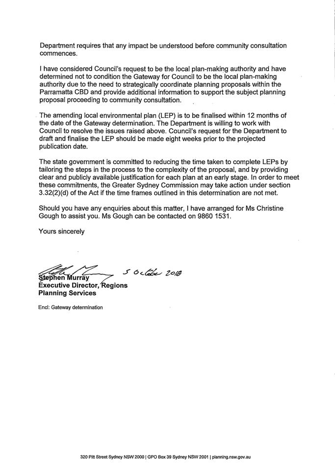
9. It is noted that the Gateway determination lapsed on 5 October 2019 and an extension was subsequently issued by the DPIE on 2 December 2019. This has extended the time frame to 5 April 2020. A further extension has been sought from the DPIE to extend for a further four months.
Draft Site-Specific DCP
10. A draft site-specific DCP (refer Attachment 3) was prepared to provide more detailed built form guidelines to supplement the LEP controls. Pursuant to Council’s resolution on 10 July 2017, the draft DCP was publicly exhibited concurrently with the Planning Proposal and draft Planning Agreement.
11. As discussed previously in this report, Council’s resolution on 9 April 2018 included additional requirements to be addressed in the DCP regarding the protection of the axial view corridor from the St John’s cemetery entrance gates along Aird Street and public domain landscaping along the eastern side of O’Connell Street.
12. In summary, the DCP seeks to achieve the following objectives:
i. Contribute to a high quality public domain at ground level with activated edges to the streets and street walls that create legible, safe, functional and attractive streets;
ii. Provide for slender, elegant towers that are setback above the street walls to allow for daylight penetration to the street, views to the sky and privacy; and
iii. Protect, frame and enhance the axial view corridor from the entry gate to St John’s cemetery along Aird Street.
13. This report recommends that the DCP controls be amended as a result of the submissions received during the exhibition, and the relevant controls are discussed in more detail later in this report.
Draft Planning Agreement
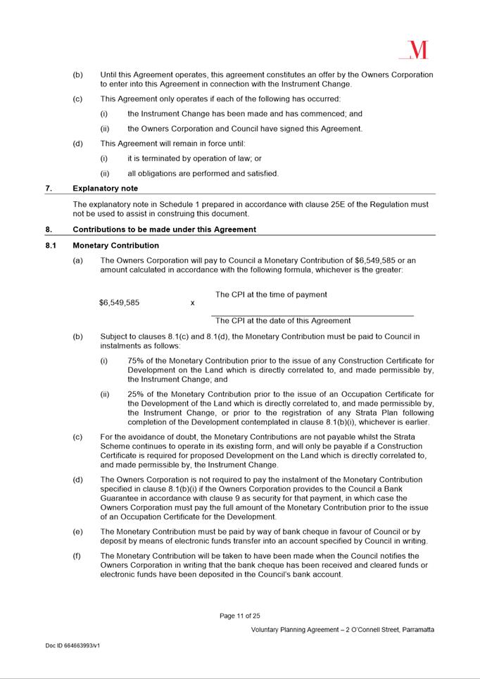
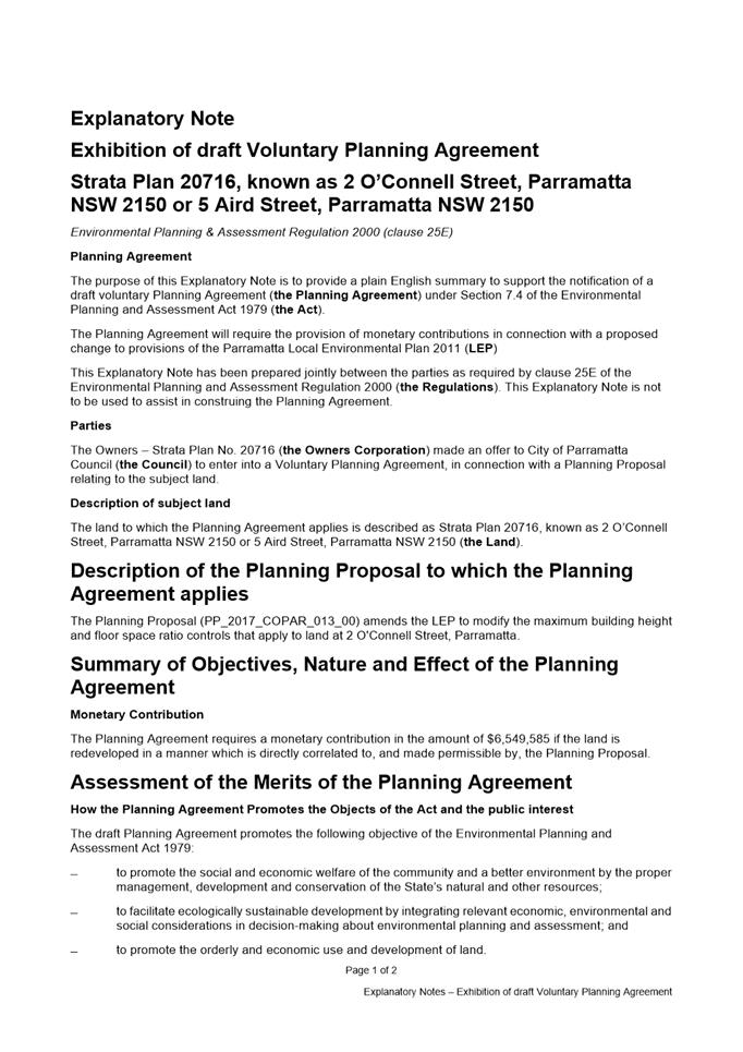
14. A draft Planning Agreement (Attachment 4) outlining a contribution towards the provision of community infrastructure in the Parramatta CBD was negotiated with the Applicant. Legal advice from Council’s solicitor was obtained regarding the provisions of the draft Planning Agreement prior to its exhibition. Pursuant to Council’s resolution on 10 July 2017, the draft Planning Agreement was publicly exhibited concurrently with the Planning Proposal and draft DCP.
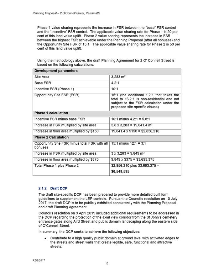
15. The draft Planning Agreement provides for a monetary contribution of $6,549,585. This is consistent with Council’s Planning Agreements Policy which references the Parramatta CBD Planning Proposal’s provisions regarding community infrastructure needs. The Parramatta CBD Planning framework includes a resolution of Council dated 10 April 2017 which applies a ‘Phase 1’ community infrastructure contribution of $150 per square metre and a ‘Phase 2’ community infrastructure contribution of $375 per square metre. The method of calculating the amount of value sharing relative to the increase in FSR is demonstrated in Figure 2 below.
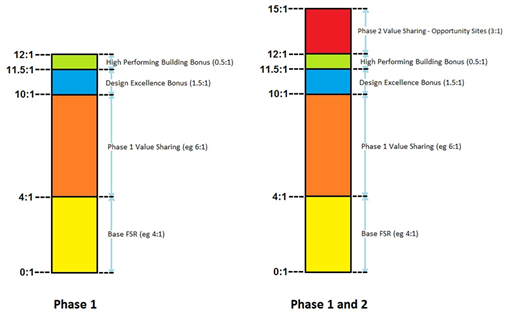
Figure 3: Method for calculating phase 1 & 2 community infrastructure contributions under the Parramatta CBD Planning Proposal
16. As shown in Figure 3, Phase 1 represents the increase in FSR between the “base” FSR control and the “incentive” FSR control. The applicable rate for Phase 1 is $150/sqm. Phase 2 represents the increase in FSR between the “incentive” FSR plus all bonuses (i.e. 12:1) and the Opportunity Site FSR of 15:1. The applicable rate for Phase 2 is $375/sqm.
17. Using the methodology above, the value of the monetary contribution contained in the draft Planning Agreement for 2 O’ Connell St is based on the calculations in Table 2 below.
Table 2. Calculation of monetary contribution in draft Planning Agreement for 2 O’Connell St
|
Development parameters |
|
|
Site Area |
3,283 m2 |
|
Base FSR |
4.2:1 |
|
Incentive FSR (Phase 1) |
10:1 |
|
Opportunity Site FSR (FSR) |
15:1 (the additional 1.2:1 that takes the total to 16.2:1 is non-residential and not subject to the FSR calculation under the proposed site-specific clause) |
|
Phase 1 calculation |
|
|
Incentive FSR minus base FSR |
10:1 - 4.2:1 = 5.8:1 |
|
Increase in FSR multiplied by site area |
5.8 x 3,283 = 19,041.4 m2 |
|
Increase in floor area multiplied by $150 |
19,041.4 x $150 = $2,856,210 |
|
Phase 2 Calculation |
|
|
Opportunity Site FSR minus total FSR with all bonuses |
15:1 - 12:1 = 3:1 |
|
Increase in FSR multiplied by site area |
3 x 3,283 = 9,849 m2 |
|
Increase in floor area multiplied by $375 |
9,849 x $375 = $3,693,375 |
|
Total Phase 1 plus Phase 2 |
$2,856,210 + $3,693,375 = $6,549,585 |
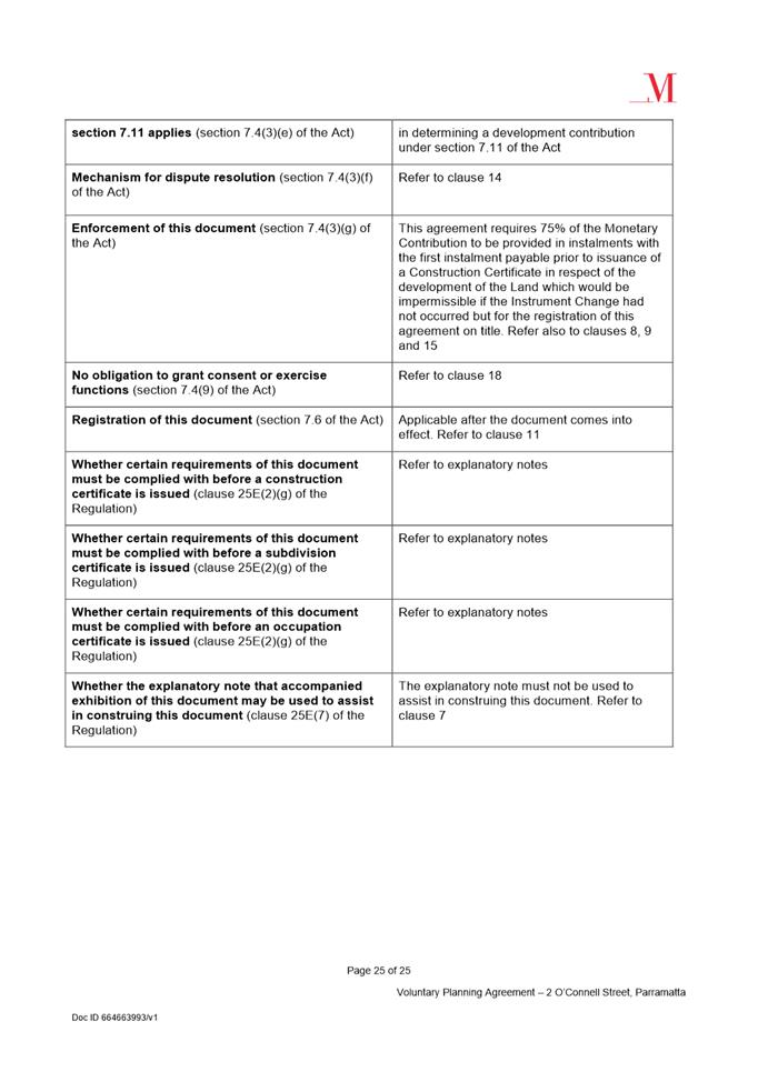
18. Under the terms of the draft Planning Agreement, 75 per cent of the contribution is to be paid prior to the issue of any construction certificate relating to the development of the site and the remaining 25 per cent of the contribution is to be paid prior to the issue of an occupation certificate (or prior to registration of a strata plan, whichever is earlier). This is consistent with Council’s Planning Agreements Policy adopted on 26 November 2018.
PUBLIC EXHIBITION
19. The Planning Proposal, draft DCP and draft Planning Agreement were publicly exhibited from 11 December 2019 to 31 January 2020 (to account for the Christmas and New Year’s period). An advertisement was placed in the local newspaper, and relevant material was made available on Council’s website and in hard copy format at Council’s Administration Building and Parramatta Central Library. Letters were sent to land owners and occupiers in the vicinity of the subject site.
20. The following public authorities were also consulted, as required by the Gateway determination:
i. Transport for NSW;
ii. Roads and Maritime Services;
iii. Office of the Environment and Heritage – Heritage Division (now known as Heritage NSW);
iv. Heritage Council;
v. Sydney Metro Airports;
vi. Endeavour Energy;
vii. DIRD; and
viii. Civil Aviation Safety Authority.
KEY ISSUES RAISED IN SUBMISSIONS
21. During exhibition, submissions were received from various public authorities and from the community. Also, additional issues were identified by Council staff during the exhibition period. These submissions are summarised and addressed below. In summary, no changes to the Planning Proposal are recommended as a result of these submissions, however some amendments to the DCP are recommended and a number of issues for clarification during the legal drafting of the LEP amendment have also been identified.
Submissions from Public Authorities
22. Council received submissions from the following public authorities:
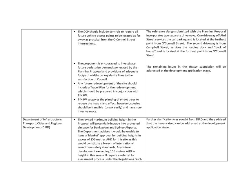
i. Department of Infrastructure, Transport, Cities and Regional Development (DIRD);
ii. Civil Aviation Safety Authority (CASA);
iii. Heritage NSW;
iv. Endeavour Energy; and
v. Transport for NSW (TfNSW)
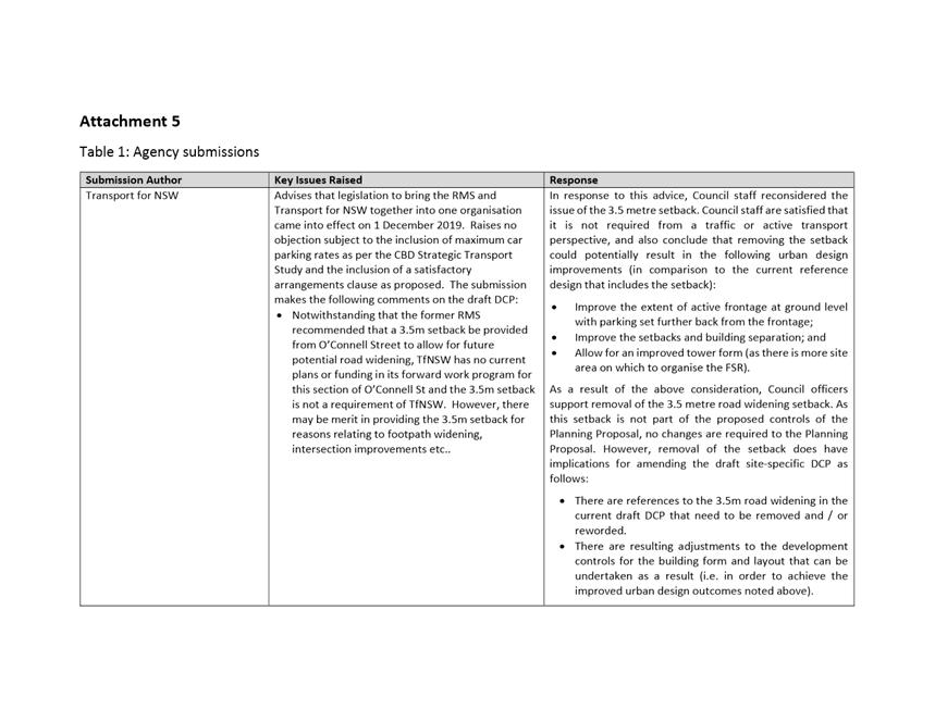
23. The issues raised in the public authority submissions and associated Officer responses are summarised in Table 1 at Attachment 5. Key issues raised by the State agencies related to airspace regulations, provision of electricity infrastructure, and potential overshadowing of heritage items.
24. With regards to the last point, Heritage NSW raised concern about potential overshadowing of St John’s Cemetery and the South Parramatta HCA. These two issues are addressed in turn below:
St John’s Cemetery: Council considered an additional report relating to overshadowing impacts on St John’s Cemetery on 9 April 2018. The report concluded that the subject site-specific Planning Proposal is capable of facilitating a future development that will not have unacceptable impacts on St. John’s Cemetery and recommended no changes to the Planning Proposal; Council accepted this recommendation and endorsed progressing the Planning Proposal with no changes.
South Parramatta HCA: An analysis of cumulative overshadowing issues on the South Parramatta and the Harris Park West HCAs was completed as part of work on the Parramatta CBD Planning Proposal. The overshadowing impact from this particular site-specific Planning Proposal on these areas was found to be negligible and therefore no change to the Planning Proposal was recommended as a result.
25. Council officers consider that the issues raised in the public authority submissions do not require any changes to the Planning Proposal as exhibited, noting that a number of matters raised in the submissions can be addressed at the Development Application stage. However, Council officers do recommend an amendment to the draft DCP as a result of TfNSW’s submission, and this is discussed in further detail in the following paragraphs.
26. TfNSW’s submission advised that, notwithstanding RMS’ prior recommendation that a 3.5 metre setback be provided from O’Connell Street to allow for future potential road widening, TfNSW has no current plans or funding in its forward work program for this section of O’Connell St and the 3.5 metre setback is not a requirement of TfNSW. In response to this advice, Council staff reconsidered the issue of the 3.5 metre setback. Council staff are satisfied that it is not required from a traffic or active transport perspective, and also conclude that removing the setback could potentially result in the following urban design improvements (in comparison to the current reference design that includes the setback):
i. Improve the extent of active frontage at ground level (as there is more room for active frontage uses to sleeve the podium parking);
ii. Improve the setbacks and building separation; and
iii. Allow for an improved tower form (as there is more site area on which to organise the FSR).
27. As a result of the above consideration, Council officers support removal of the 3.5 metre road widening setback. As this setback is not part of the proposed controls of the Planning Proposal, no changes are required to the Planning Proposal. However, removal of the setback does have implications for amending the draft site-specific DCP as follows:
i. There are references to the 3.5 metre road widening in the current draft DCP that need to be removed and / or reworded.
ii. There are resulting adjustments to the development controls for the building form and layout that can be undertaken as a result (i.e. in order to achieve the improved urban design outcomes noted above).
Council officers recommend that these changes should be made to the draft DCP, and that it should be re-exhibited and reconsidered by Council prior to notification of the Planning Proposal.
Community Submissions
28. Twelve submissions were received from the community, comprising eleven submissions from nearby residents and one submission from the the owners of Westfield. The main concern raised in the community submissions related to the potential for structural damage to adjoining buildings during the construction phase. Concerns about traffic congestion, overshadowing and loss of views were also raised. A detailed response from Council officers to the community submissions is in Table 2 at Attachment 5, and this information is summarised in the table below.
Table 3: Summary of issues raised in community submissions/Council officer response
|
Issue raised |
Council Officer Response |
|
Westfield Submission |
|
|
Supports the proposal subject to some further consideration of the Aird Street public domain and future ground floor interface of the site to Aird Street. |
Noted |
|
Objects to certain aspects of the applicant’s reference design. The Aird Street car park entrance includes a blank masonry wall which does not meet the objectives of the draft DCP. |
The submission from TfNSW no longer requires a 3.5 metre setback from the O’Connell Street frontage. This affords Council the opportunity to revisit the setbacks and the DCP controls. As noted previously in this report, this would improve the extent of ground floor retail facing Aird Street rather than car parking. |
|
The reference design and draft DCP should be amended to require the first 10m ground floor frontage from Aird Street (other than the car park entrance) to be sleeved with active commercial land uses. |
As noted previously in this report, removal of the 3.5 metre setback will allow for insertion of DCP controls improving the extent of ground floor retail facing Aird Street rather than car parking. |
|
Due to the narrow footpath width on Aird Street, the entire podium facing Aird Street should be set back 1.2 metres (not just the ground floor) so to allow more space for large street trees. |
Council’s City Design Team have recommended that the podium not be set back from the site boundary along Aird St, as this would require the main tower to be set back further as well thereby reducing building separation with the building to the south. In addition, the street wall to Aird St would not line up with the street wall of the adjacent building if the entire podium was set back further.
The existing footpath width on Aird Street (approx. 3.7 metres and similar to O’Connell St and Campbell St) with the setback at ground level nominated in the DCP (of 1.2 metres) is sufficient to accommodate a generous footpath as well as street trees, which will be consistent on all frontages. |
|
The PP should include a Public Domain Concept Plan. |
Planning Proposals of this nature do not generally include public domain concept plans. Public domain interface is addressed in the DCP controls, and will be further considered at the Design Competition and Development Application stages. |
|
Main issues raised in submissions received by local residents |
|
|
Many of the submissions raised concern about the risk of structural damage to adjoining buildings from the construction of the proposal such as occurred with Mascot Towers. Further, submissions queried what measures Council would take to ensure there would be no damage to neighbouring apartments.
|
Any development consent issued for the construction of the proposal in the future would include a standard condition that requires the developer to prepare dilapidation reports of both public and private infrastructure – before and after construction. This establishes the pre-existing condition of adjoining buildings and the condition after construction. Any adjoining resident who has concerns during the construction phase can contact Council to seek advice. Further, the State Government has also recently appointed a NSW Building Commissioner in response to concerns regarding construction standards. The Commissioner has been given a team of auditors and legislative powers to conduct site audits during construction and tools to identify those projects that are at highest risk. Draft legislation is also currently being considered which aims to improve industry standards and practices and make designers and builders more accountable. Information on the NSW Building Commissioner and the related initiatives can be accessed online: www.customerservice.nsw.gov.au/about-us/building-commissioner |
|
The existing Westfield car park entrance/exits and truck loading docks already create a lot of traffic congestion in the immediate area. An additional 455 apartments will make this significantly worse. |
The traffic implications of individual site-specific Planning Proposals have been considered within the Parramatta CBD Strategic Transport Study (STS) prepared as part of the Parramatta CBD Planning Proposal. Where a site-specific Planning Proposal is consistent with the density anticipated under the Parramatta CBD Planning Proposal, the issues of traffic generation are addressed by applying the reduced car parking rates endorsed by Council as an outcome of the STS. Impacts on specific intersections are assessed as part of a Development Application and any required intersection upgrade works would be required as part of relevant conditions of consent.
|
|
Raises concerns with the overshadowing of public amenities and heritage items in the morning. In particular: Prabha Memorial Walk, Mays Hill Oval, Parramatta Park, Parramatta High School which would be overshadowed between sunrise and 9am. Would also impact on Mays Hill tennis courts and netball courts.
|
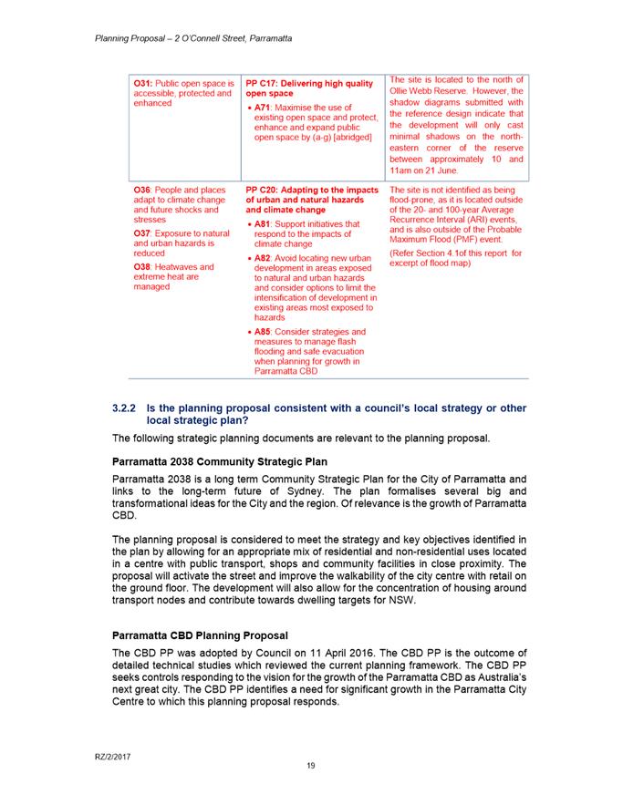
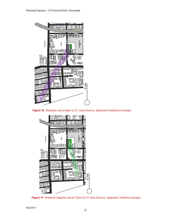
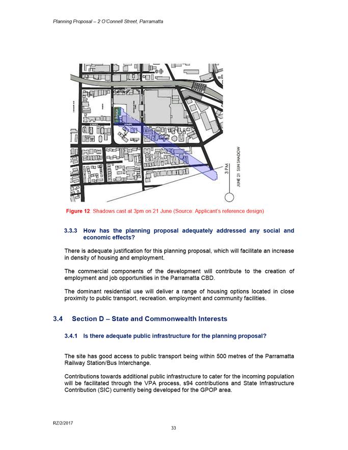
It is acknowledged that the proposal will result in overshadowing of a significant number of properties in the locality due to the height of the tallest tower (217 metres). It is inevitable that any development undertaken in line with the Parramatta CBD Planning Proposal is likely to generate overshadowing impacts. However, as the proposal consists of tall, slender building forms, this helps minimise the effects of overshadowing on neighbouring properties due to the narrow and fast moving nature of the shadows.
It is also noted that the Gateway determination issued by DPIE for the subject site required assessment of the cumulative overshadowing on the South Parramatta and Harris Park West Heritage Conservation Areas.
This assessment indicated that the Planning Proposal would not overshadow the Harris Park West or South Parramatta Heritage Conservation Areas between 9.00am and 3.00pm on 21 June. Any overshadowing of Prabha Memorial Walk, Mays Hill Oval, Parramatta Park and Parramatta High School would be very early in the morning prior to school hours.
With regard to cumulative impacts, the overshadowing in the Parramatta CBD Technical Paper assessed the total effect of the building heights permitted under the CBD Planning Proposal including the height sought for 2 O’Connell Street under the subject proposal.
The report does not identify any shadow impact issues/concerns with the subject site 2 O’Connell Street as it is of a sufficient distance to the north and also benefits from being lower in topography so as to have a negligible overshadowing impact on any Heritage Conservation Area.
As such, the study did not identify any amendments to the height control recommended as part of the CBD Planning Proposal for this particular site, and therefore, no amendments to the site-specific Planning Proposal are recommended. |
|
The proposal will obstruct views from existing residential buildings. |
It is understood that many units within 15 Campbell Street benefit from extensive views due to the elevated topography of the site and the height of the building. The tallest tower within the proposal will likely obstruct views from the existing apartment buildings, particularly those from the north-facing units within 15 Campbell Street. The proposal will likely obstruct these existing views north towards Parramatta Park. It is inevitable that development undertaken in line with the Parramatta CBD Planning Proposal is likely to result in some view obstruction as a result of tower development. |
29. In conclusion, it is not considered that any of the community submissions raise issues that require alteration of the Planning Proposal. Further, several concerns raised therein will be addressed at the Development Application stage through conditions of consent.
Issues identified by Council Officers during public exhibition
30. Clause drafting: The exhibition material contained a potential draft LEP clause that would be added to the LEP to implement the controls sought in the Planning Proposal. Some technical issues have been identified with the way the draft clause was structured and worded. However, the clause was provided for informational purposes only, as final clauses are drafted by Parliamentary Counsel on behalf of the State Government (not by Council Officers). During the legal drafting stage, all technical issues will be addressed to ensure the outcomes provided by the new clause are consistent with the objectives of the site specific Planning Proposal.
31. Clarification of height and relationship to Design Excellence bonus: The explanatory page for the exhibited materials erroneously noted that the Planning Proposal sought to increase the height to 217 metres excluding Design Excellence, whilst the draft clause of the Planning Proposal itself outlines that 217 metres includes a Design Excellence bonus. For clarification’s sake, Land Use Planning staff advise that the Planning Proposal seeks to change height controls to a maximum of 217 metres inclusive of the Design Excellence bonus. It is considered that while the exhibition materials erroneously displayed two different heights (i.e. 217 metres including Design Excellence bonus vs. 217 metres excluding Design Excellence bonus, or approximately 250 metres), the correct figure is the lower of these two heights, and therefore the community has had the opportunity to consider the maximum possible change considered under the amended controls. Therefore, it is not recommended to re-exhibit the Planning Proposal as a result of this issue. However, the Planning Proposal, Development Control Plan and Planning Agreement should be checked, and any administrative amendments necessary should be made to ensure that this matter is clarified and made consistent across all documents. It is noted, for instance, that the instrument change was also erroneously described in the Planning Agreement, and that an administrative amendment to the Planning Agreement should be undertaken to ensure that the instrument change is accurately described (i.e. that the height of 217 metres is inclusive of Design Excellence).
32. Potential mismatch of height and FSR: A concern was raised by Council officers that the height and FSR may be mismatched, as the mapped FSR does not include a potential extra 0.5:1 FSR for meeting high performing building criteria nor the potential extra 1.2:1 of non-residential floor space. Therefore, concerns were raised about whether this FSR is appropriately matched to the height of 217 metres. Land Use Planning officers consider that the exhibited reference design includes all potential FSR bonuses on site, and generally responds to the 217 metre height control (noting that the exhibited reference design including road widening setback has a maximum height of approximately 224 metre due to change in levels at the site). As noted above, the 3.5 metre road widening setback is no longer required; therefore, it is anticipated that the overall height of the final building design will fully conform to the height limit, as there is now “more room” to fit in the FSR over an enlarged site area (due to removal of the 3.5 metre setback). No changes to the controls in the Planning Proposal are recommended as a result, as the applicant has confirmed a revised reference design showing removal of the 3.5 metre road widening setback and a building with an FSR of 16.2:1 fitting within 217 metres height.
33. Additional matters for inclusion in an amended DCP: The review by Council officers has identified the following issues that can be addressed, and recommend the following amendments be made to the Draft DCP prior to the re-exhibition:
i. Addition of a section on heritage that refers to the LEP provision relating to heritage transition and contains controls outlining that a development that complies with the DCP is taken to have provided an appropriate transition to heritage items, as the building envelope accounts for matters such as the axial view down Aird Street from the cemetery gates. This section of the amended DCP should also detail that the heritage assessment report otherwise required by the existing controls in Parramatta DCP 2011 should ensure that the building design and materials take into consideration the relationship of the building and the heritage item.
ii. Controls relating to selecting building materials to minimise reflectivity and glare impacts.
CONSULTATION & TIMING
34. It is recommended that an amended draft DCP as discussed in this report is prepared and re-exhibited, and that Council considers the outcomes of this exhibition and endorses the final DCP prior to the Planning Proposal being finalised.
FINANCIAL IMPLICATION FOR COUNCIL
35. As outlined previously in this report, the exhibited draft Planning Agreement makes provision for a contribution to community infrastructure in the Parramatta CBD which aligns with Council’s policy framework on this matter.
Felicity Roberts
Project Officer-Land Use Planning
Robert Cologna
Team Leader Land Use Planning
David Birds
Group Manager, City Planning
Jennifer Concato
Executive Director City Strategy & Development
|
1⇩ |
Planning Proposal |
52 Pages |
|
|
2⇩ |
Gateway determination |
4 Pages |
|
|
3⇩ |
Draft site-specific Development Control Plan |
8 Pages |
|
|
4⇩ |
Draft Planning Agreement and Explanatory Note |
27 Pages |
|
|
5⇩ |
Summary table of submissions |
13 Pages |
|
REFERENCE MATERIAL