Local Planning Panel 23 May 2024 Item 5.1
ITEM NUMBER 5.1
SUBJECT Post Exhibition: Planning Proposal, Draft Planning Agreement and Draft Site-Specific Development Contol Plan at 263-281 Pennant Hills Road, Carlingford
REFERENCE RZ/5/2023 -
APPLICANT/S Karimbla Properties (No. 61) Pty Ltd
OWNERS Karimbla Properties (No. 61) Pty Ltd
REPORT OF Group Manager, Major Projects and Precincts
PURPOSE
The purpose of this report is to seek the Parramatta Local Planning Panel’s advice to Council on a recommendation to support finalisation of a Planning Proposal, Draft Planning Agreement and Draft Site-Specific Development Control Plan (DCP) for 263-281 Pennant Hills Road, Carlingford (previously known as 263-273 Pennant Hills Road and 18 Shirley Street, Carlingford).
The Local Planning Panel consider the following Council Officer recommendation in its advice to Council:
(a) That Council note the submissions received in response to the exhibition of the Planning Proposal, Development Control Plan (DCP) and Draft Planning Agreement as summarised and responded to in Attachment 3 for 263-281 Pennant Hills Road, Carlingford.
(b) That Council approve the Planning Proposal (Attachment 1) for land at 263-281 Pennant Hills Road, Carlingford which seeks to amend the Parramatta Local Environmental Plan 2023 (PLEP 2023) in relation to the subject site by:
i. Reconfiguring the existing R4 High Density Residential and RE1 Public Recreation zones and retaining the existing SP2 Infrastructure Zone.
ii. Amending the Maximum Height of Building control by:
· Amending the maximum height of buildings on the Pennant Hills Road frontage from 27 metres (9 storeys) to part 65 metres (18 storeys), part 69 metres (17 storeys), part 110 metres (29 storeys) and part no height as per Figures 17 & 23 in Attachment 1;
· Amending the maximum height of buildings on the remainder of the site from part 33 metres (11 storeys) and part no height to part 33 metres (8 storeys), part 46 metres (11 storeys) part 56 metres (14 storeys) and part no height as per Figures 17 & 23 in Attachment 1;
iii. Increasing the Maximum Floor Space Ratio control for the R4 High Density Residential zoned land from 2.3:1 to 3.6:1.
iii. Amending Schedule 1 Additional Permitted Uses to increase the maximum gross floor area of parts of the buildings used for business premises, food and drink premises, recreational facilities (indoor) and shops on the R4 High Density Residential zoned part of the site from 2,000 sqm to 2,600 sqm.
v. Amending the Land Reservation Acquisition (LRA) Map to include all RE1 Public Recreation land on the site that will be dedicated to Council.
(c) That Council enters into the Planning Agreement and delegates authority to the Chief Executive Officer to sign it on behalf of Council.
(d) That Council approves the DCP controls at Attachment 2 for insertion into Part 8 of the Parramatta DCP 2023.
(e) That Council delegate authority to the Chief Executive Officer to make any minor amendments and corrections of a non-policy and administrative nature that may arise during the plan finalisation process relating to the Planning Proposal, DCP and Planning Agreement.
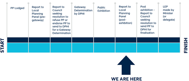
PLANNING PROPOSAL TIMELINE
SUMMARY
1. This report seeks the advice of the Parramatta Local Planning Panel to Council on a recommendation to support finalisation of a Planning Proposal, DCP and Planning Agreement for 263-281 Pennant Hills Road, Carlingford.
2. The Planning Proposal seeks to amend Parramatta Local Environmental Plan 2023 (PLEP 2023) to develop the site for high density residential development and community and commercial uses including reconfiguring the existing residential and open space zoning.
3. The Planning Proposal, DCP and draft Planning Agreement were placed on public exhibition from 25 March 2024 to 24 April 2024, with one hundred and thirty-three (133) submissions received comprising of one hundred and twenty-eight (128) from the community, three (3) from organisations, businesses and strata committees and two (2) agency submissions. A summary of the key issues raised in the submissions is provided in this report with a more detailed analysis provided in Attachment 3.
BACKGROUND
4. In September 2023, Karimbla Properties (No.61) Pty Ltd lodged a Planning Proposal with the City of Parramatta Council for land at 263-281 Pennant Hills Road, Carlingford to enable the development of the site for high density residential development and community and commercial uses including reconfiguring the existing residential and open space zoning.
5. On 8 November 2023, the Local Planning Panel (LPP) provided advice to Council recommending it approve the Planning Proposal for the purposes of requesting a Gateway Determination.
6. On 4 December 2023, Council approved the Planning Proposal for the purposes of requesting a Gateway Determination from DPHI.
7. On 19 February 2024, DPHI issued a Gateway Determination (Attachment 4) which allowed the Planning Proposal to proceed to public exhibition.
8. The Planning Proposal, draft Planning Agreement and DCP were publicly exhibited from 25 March to 24 April 2024. This report addresses the outcomes of that exhibition and makes recommendations for progressing the matter.
9. The site has a complex planning history detailed at Attachment 5.
SITE DESCRIPTION
10. The subject site (Figure 1) is known as 263-281 Pennant Hills Road, Carlingford (previously known as 263-273 Pennant Hills Road and 18 Shirley Street, Carlingford) and comprises of seven lots which are legally described as follows in Table 1:
Table 1 – Property Address - Lots and DPs
|
Property Address |
Lot & DP |
|
263-281 Pennant Hills Road, Carlingford |
Lot 22, DP 21386 |
|
Lot 2, DP 9614 |
|
|
Lot 3, DP 9614 |
|
|
Lot 4, DP 9614 |
|
|
Lot 62, DP 819136 |
|
|
Lot 61, DP 819136 |
|
|
Lot 1, DP 1219291 |
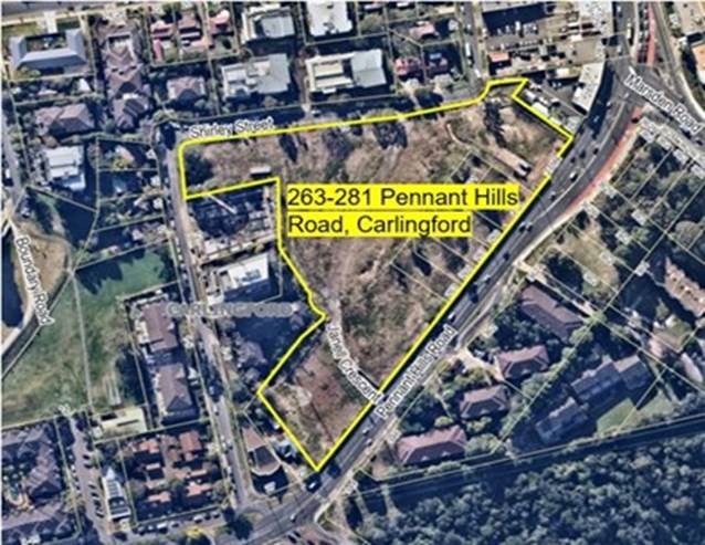
Figure 1 - Subject Site
11. The site is irregular in shape and has a total area of approximately 27,987 sqm, made up of 6,050 sqm of RE1 Public Recreation zoned land and 21,880 sqm of R4 High Density Residential zoned land and 57 sqm of SP2 Infrastructure zoned land.
12. The site is located on the western side of Pennant Hills Road (classified road) and the southern and eastern sides of Shirley Street (local road). The site is predominately undeveloped and cleared of vegetation.
13. The site is located approximately 400 metres east from the Carlingford Light Rail stop and 60 metres to the south of the Carlingford Village shopping centre (Figure 2).
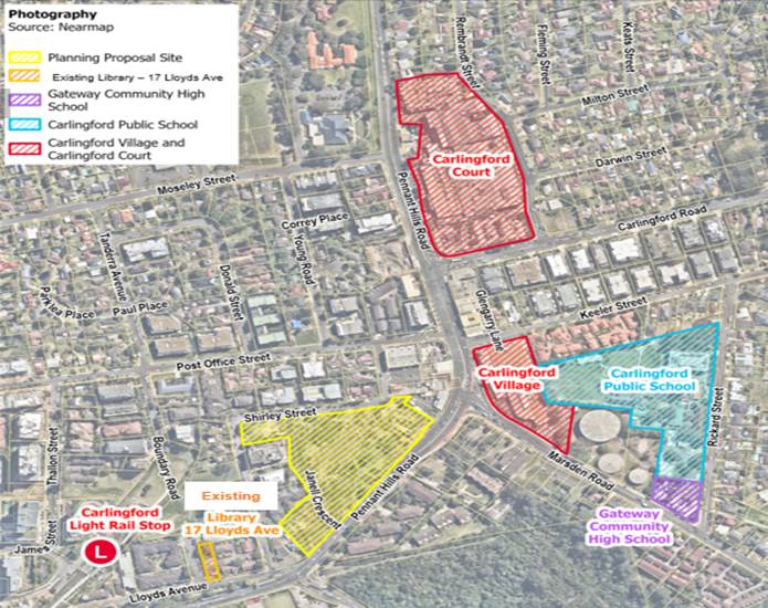
Figure 2 – Local Context Map
PLANNING PROPOSAL
14. The Planning Proposal seeks to facilitate a higher density mixed use development scheme (Figure 3) on the site than is allowed under the current planning controls by increasing the Floor Space Ratio and Height of Building controls and reconfiguring the layout of R4 High Density Residential and RE1 Public Recreation zoned land. The proposal also includes a substantial public benefit offering including a community hub (library and community centre) and reconfigured open space. Further details are outlined in the Planning Proposal at Attachment 1.
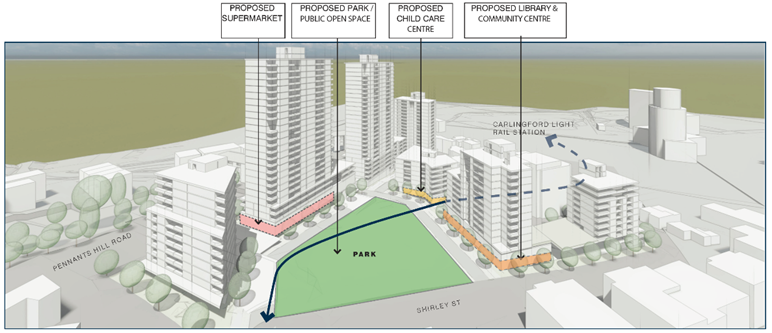
Figure 3 – Reference Scheme
15. Table 2 describes the instrument changes being sought under the Planning Proposal compared with the current controls under PLEP 2023. Refer to the Planning Proposal (Attachment 1) for mapping changes.
Table 2 – Proposed PLEP 2023 Amendments
|
|
Existing as per PLEP 2023 |
Dyldam DA – existing consent (Excludes the 6 small lots facing Pennant Hills Road) |
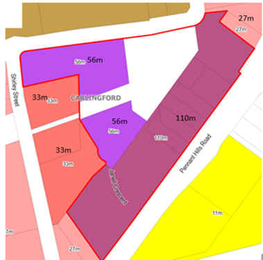
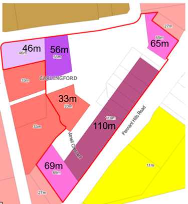
Proposed changes to PLEP 2023 – As exhibited |
Proposed changes to PLEP 2023 – Proposed Post Exhibition Amendments |
|
Zoning |
Part R4 High Density Residential, Part RE1 Public Recreation and Part SP2 Infrastructure |
Part R4 High Density Residential, Part RE1 Public Recreation, Part SP2 Infrastructure |
Reconfigured part R4 High Density Residential and RE1 Public Recreation.
Existing SP2 Infrastructure to remain as is. |
No change proposed Reconfigured part R4 High Density Residential and RE1 Public Recreation.
Existing SP2 Infrastructure to remain as is. |
|
Site Area |
27,987 sqm |
23,482 sqm |
27,987 sqm |
No change proposed 27,987 sqm |
|
Dwelling Yield |
526 |
450 on Dyldam site |
723 |
No change proposed post exhibition 723 |
|
GFA |
50,454 sqm residential |
Total GFA 53,069 sqm residential
|
Total GFA 80,510 sqm - 74,655 sqm residential - 2,500 sqm Community Hub - 550 sqm childcare centre - 2,600 sqm non-residential - 5,585 sqm of RE1 Public Open Space
|
No change proposed Total GFA 80,510 sqm - 74,655 sqm residential - 2,500 sqm Community Hub - 550 sqm childcare centre - 2,600 sqm retail/commercial - 5,585 sqm of RE1 Public Open Space |
|
HoB |
Part 33m (11 storeys) and part 27m (9 storeys)
|
Part 27m (9 storeys) on Pennant Hills Road and Part 33m (11 storeys) on the remainder of the site.
|
Part 110m (29 storeys) on Pennant Hills Road frontage Part 56m (18 storeys) on the remainder of the R4 part of the site.
|
Change to proposed heights Part 65m (17 storeys), Part 69m (18 storeys), Part 110m (29 storeys) and Part no height limit on the Pennant Hills Road frontage. Part 33m (8 storeys), Part 46m (11 storeys). Part 56m (14 storeys) and part no height limit on the remainder of the site. |
|
FSR |
2.3:1 |
3:1 (excluding open space) |
3.6:1 |
No change proposed 3.6:1 |
|
Additional Permitted Uses |
As per Schedule 1 of PLEP 2023 shops, food and drink premises and business premises and recreation facilities (indoor) on the R4 High Density Residential zoned part of the site - maximum GFA of 2,000 sqm on the R4 High Density Residential zoned part of the site. |
NA |
Schedule 1 of PLEP 2023 to shops, food and drink premises, business premises and recreation facilities (indoor) on the R4 High Density Residential zoned part of the site - maximum GFA of 2,600 sqm on the R4 High Density Residential zoned part of the site. |
No change proposed Schedule 1 of PLEP 2023 to shops, food and drink premises, business premises and recreation facilities (indoor) on the R4 High Density Residential zoned part of the site - maximum GFA of 2,600 sqm on the R4 High Density Residential zoned part of the site. |
|
Land Reservation Acquisition (LRA) |
A small sliver of SP2 Classified Road land on the southern part of the site along Pennant Hills Road is already marked on the Land Reservation Acquisition Map. |
N/A |
A portion of RE1 Public Open space (4,760 sqm) land known as the Central Park was added to the proposed Land Reservation Acquisition Map as it is be dedicated to Council as part of the Planning Agreement. |
Change to amount of land to be added to the LRA Map RE1 Public Open space (5,585 sqm) land on the site has been added to the proposed Land Reservation Acquisition Map as it will be dedicated to Council, as part of the Planning Agreement, changed to include the Community Link. |
16. The existing development consent that only applies to the larger lot on Shirley Street allows a 30% increase in the floorspace currently permitted on that site (as the RE1 Public Open Space land was included in the calculations of floor space ratio) to 53,069 sqm which equates to an FSR of 3:1 for that site. The subject Planning Proposal seeks a total floorspace of 80,510 sqm which equates to an FSR of 3.6:1 when the six lots fronting Pennant Hills Road are added to the site and public open space is excluded from the calculation of FSR.
17. It is also noted there was a development application refused by the Sydney Central City Planning Panel on 7 December 2022 for 263-281 Pennant Hills Road, Carlingford. The DA is currently the subject of a current appeal to the Land and Environment Court.
18. On 19 February 2024, DPHI issued a Gateway Determination for the Planning Proposal which authorised Council to be the local plan-making authority and allowed the public exhibition of the Planning Proposal to proceed.
19. The Gateway Determination required that prior to public exhibition the Planning Proposal be updated to:
· Identify the proposed changes to the Land Reservation Acquisition (LRA) map;
· Update the site address of the proposal;
· Include further justification on the overshadowing impacts to properties south of Pennant Hills Road, particularly to demonstrate compliance with this aspect of the Apartment Design Guide can be achieved; and
· Include discussion on the public amenity and proposed overshadowing of heritage item I032 – Carlingford.
All of these conditions were met prior to public exhibition of the Planning Proposal. Refer to the Planning Proposal at Attachment 1 for details.
20. Council staff requested the Applicant provide additional information regarding compliance with the Apartment Design Guide (ADG) regarding overshadowing impacts on 346-362 Pennant Hills Road and 2-6, 8 and 12 Shirley Street, Carlingford. As detailed in the Planning Proposal (Attachment 1) the additional analysis provided by the applicant indicates that the subject proposal is able to satisfy the ADG requirements in this regard. In relation to 2-6 Shirley Street, the Applicant has demonstrated that this property would already be overshadowed by the previously approved development for the subject site and the proposed scheme would primarily be impacted by a building within the currently applicable maximum height of building control.
21. In order to respond to issues raised in public submissions regarding height, overshadowing impacts and visual impact, it is proposed that the maximum exhibited heights of part no height limit, part 110 metres on Pennant Hills Road and part 56 metres on the remainder of the site have been amended to:
· Part 65 metres, part 69 metres, part 110 metres and part no height limit on the Pennant Hills Road frontage; and
· Part 33 metres, part 46 metres, part 56 metres and part no height limit on the remainder of the site.
It is noted that no height limit does not mean unlimited height, rather it is where there is intended to be no development on public open space or the community link on Pennant Hills Road. This is considered in detail later in the Key Issues section of this report and in the Community Engagement Report at Attachment 3 to this report.
22. As noted in Table 2 the exhibited LRA Map is proposed to be amended post exhibition to include all RE1 Public Open Space rather than only the Central Park. This is a result of further negotiations between Council staff and the applicant in relation to the Planning Agreement. This is discussed in more detail in the Planning Agreement section of this report.
PLANNING AGREEMENT
23. There is a draft Planning Agreement linked to the Planning Proposal which proposes to deliver the following public benefits at a value estimated by the applicant to be $27.5 million. Items included in the draft Planning Agreement are listed below (also refer to Figure 4):
· Construction and dedication of a library (1,800 sqm net leasable area) and community facility (700 sqm net leasable area) known as the community hub.
· Construction, embellishment and dedication of all proposed RE1 Public Open Space land (5,585 sqm) on the site in the form of a Central Park and a Community Link.
· Embellishment of pedestrian easement and provision of 24-hour access. The area of the easement is 595 sqm.
· An additional monetary contribution equivalent to Section 7.11 Contributions for allocation to the fit-out of the community hub and embellishment of open space within the vicinity of the site.
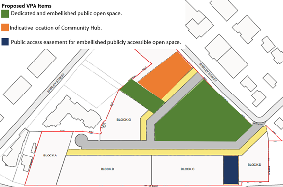
Figure 4 – Proposed VPA Items
24. As a result of negotiations between Council staff and the applicant there have been some minor amendments to the draft Planning Agreement since the Letter of Offer was reported to the Local Planning Panel and Council pre-exhibition. Council officers initially declined the offer of dedication of the Community Link to Shirley Street due to its limited recreational capacity as previously reported to the LPP and Council. Since then, the design of the Community Hub has been refined so it is now considered appropriate for the link to be dedicated to Council to facilitate access to the Hub.
SITE-SPECIFIC DEVELOPMENT CONTROL PLAN
25. A draft DCP (Attachment 2) was prepared by Council officers and the applicant to accompany the Planning Proposal. The draft SSDCP provides details on site arrangement, road layout, envelope controls and open space for the site. The SSDCP seeks to guide future development for the site. The draft DCP includes objectives and controls concerning requirements for:
· Site-specific built form and public domain.
· Community hub and library design.
· Sustainability and water management.
· Open space and pedestrian connections.
· Vehicle access and parking.
26. Several changes have been made to the draft DCP as a result of the public exhibition and further review to ensure it can be applied in a manner that achieves the intended outcomes. The changes range from rewording of some controls to reflect their initial intent to provide clarification, typographical correction, consolidation of sections and removal of text to prevent duplication with the existing controls of Parramatta DCP 2023. These changes are detailed later in this report.
PUBLIC EXHIBITION AND CONSULTATION
27. The Planning Proposal, DCP and draft Planning Agreement were publicly exhibited from 25 March to 24 April 2024. The exhibition consisted of:
· Notification Letters to neighbouring landowners and occupiers within a radius of approximately 250m.
· Notices in Parra News published on 26 March and 9 April 2024.
· Relevant material shared on City of Parramatta Council's corporate website and community engagement platform.
· Information shared on Participate Parramatta.
· Material shared on the NSW Planning Portal.
· A Media Release on the City of Parramatta website.
· Phone-a-planner sessions.
· In person sessions.
· Social media (Facebook and Instagram).
· Hard copy materials distributed at PHIVE Customer Service Centre; Carlingford Library; and Council Reception at 126 Church Street, Parramatta.
28. Public agencies were also notified via email and the NSW Planning Portal of the public exhibition, with the following agencies consulted:
· Transport for NSW (TfNSW).
· School Infrastructure NSW (SINSW).
· Department of Planning, Housing and Infrastructure - Crown Lands.
29. Two organisations were also notified via email of the public exhibition as follows:
· The Epping Chamber of Commerce.
· The Epping Civic Trust.
30. A total of one hundred and thirty-three (132) submissions were received comprising one hundred and twenty-eight (128) from the community, with the remaining five (4) from public agencies and other organisations (breakdown provided in Table 4). This total does not include where multiple submissions are made by the same person which are then counted as one submission.
Table 4 – Breakdown of submissions received.
|
|
Number |
Breakdown |
Support |
Not Support |
Neither Support nor Not Support |
|
Individuals, residents, and landowners |
127 |
Various individuals, residents, and landowners |
11 (9%) |
104 (82%) |
12 (9%) |
|
Public Agencies |
1 |
· Transport for NSW (received) · SI NSW (awaited) · DPHI - Crown Lands (awaited) |
0 (0%) |
0 (0%) |
1 (100%) Advisory Comments |
|
Other Organisations Businesses and Strata Committees |
3 |
· Vicinity Centres · Epping Civic Trust · Strata Management Committee for 2-6 Shirley Street, Carlingford |
0 (0%) |
2 (67%) |
1 (33%) |
|
Total |
131 |
|
11 (8%) |
106 (81%) |
14 (11%) |
Calculations rounded to nearest whole number
31. Additional information and data related to the public exhibition and submissions can be found in the Community Engagement Report at Attachment 3 of this report. Key issues raised by submitters and Council officer responses to the matters raised are set out in the following section. More details on matters raised and Council officer responses are in the Community Engagement Report at Attachment 3.
COUNCIL OFFICER RESPONSES TO KEY ISSUES RAISED IN SUBMISSIONS
32. Key issues raised in the submissions are reviewed in the following sections with Council Officer responses to the matters raised. More details are provided in the Community Engagement Report at Attachment 3.
(a) Impact of Increased Density
33. Several submissions raised concerns regarding the density of development proposed by the Planning Proposal, the growing density of Carlingford and impacts on infrastructure provision, in particular the ability of local facilities, shopping facilities and health services and schools.
Council Officer Response
34. The City of Parramatta Local Strategic Planning Statement (LSPS) identifies Carlingford as a 'growth centre’ that is expected to continue to develop with the introduction of improved local public transport services through connection to the Parramatta Light Rail system. It is considered appropriate to examine the potential of development sites in the locality to provide further housing to help contribute towards meeting housing need in the context of the current housing crisis identified by the State Government. In that respect the Minister for Planning wrote to all councils and planning panels in August 2023 asking them to ‘prioritise the delivery of housing when assessing development applications and rezoning schemes, so that the entire planning system is geared to addressing the housing shortfall’. The Minister further asks that ‘...council teams prioritise the opportunity to deliver homes as part of merit considerations where, on balance, dwelling numbers may warrant a scale or built form that is different to or greater than the outcome originally anticipated’ (see Attachment 6).
35. As Carlingford has been specifically identified as a suitable location to accommodate more growth and will soon benefit from enhanced public transport services located close to the subject site via the Parramatta Light Rail the site is well placed to help meet current housing supply demand. This is consistent with the Council’s resolution when approving the submission of the Planning Proposal for a Gateway determination on 4 December 2023 that it also:
i. Notes that the planning controls for this part of Carlingford were prepared by The Hills Shire Council 11 years ago.
ii. Notes that this part of Carlingford is located in an already identified Growth Precinct in accordance with Council’s Local Strategic Planning Statement (LSPS) and Local Housing Strategy (LHS) presenting an opportunity to optimise the potential for this Growth Precinct to accommodate housing growth; and
iii. Request the CEO to investigate the work required to review the planning controls for this Growth Precinct and for this to inform the 2024/25 budget.
36. In relation to demand on local infrastructure, the Planning Proposal is accompanied by an associated draft Planning Agreement that provides for the dedication of 4,760 sqm of centralised open space, a community link of 863 sqm that will be dedicated to Council and will be publicly accessible. The Planning Agreement also provides for the delivery of a warm shell Community Hub (including Library and Community Space) that will remain in Council’s ownership and be publicly accessible. The Community Hub is identified in Council‘s Outside of CBD Development Contributions Plan and Community Infrastructure Strategy as essential infrastructure needed to service the growing Carlingford community. This proposal provides the opportunity for the early delivery of the Community Hub.
37. Whilst SINSW had not provided a submission in response to consultation on the Planning Proposal at the time of finalising this report, previous advice received from SINSW prior to the Council Meeting of 4 December 2023 indicated that there was sufficient capacity in the existing and planned schools upgrades to accommodate the potential student increase associated with the proposal. An update will be provided on the SINSW response at the LPP meeting.
38. Public medical facilities are the responsibility of the State Government and the State government is aware of the areas that will receive the most growth and will need to ensure an appropriate level of service is provided in these areas.
39. In relation to the demand for retail services and private health facilities, the proposal includes incorporation of new retail land uses, including a supermarket, to serve the local resident population.
40. The Planning Proposal presents the opportunity to accommodate more housing growth in an already identified Growth Precinct in accordance with Council’s LSPS and LHS. It has been acknowledged as having strategic merit by DPHI when issuing the Gateway determination. The outcome of the Planning Proposal will generate greater public benefits than the existing development controls and consent for the site, provide a much better distribution of open space and building layout, and deliver much greater community infrastructure benefit. It is therefore considered appropriate that the Planning Proposal proceeds to finalisation to enable the density of development proposed to be delivered at the site in the manner facilitated by the Planning Proposal and SSDCP.
Council Officer Recommendation
41. Retain provisions as exhibited.
(b) Traffic
42. One of the most common themes was related to potential traffic impacts of the proposal and existing traffic congestion on the local road network and pedestrian safety.
Council Officer Response
43. Whilst it is acknowledged that the proposal will generate additional traffic, the Applicant’s Traffic Impact Assessment (TIA) indicates that the estimated traffic generated by the proposal is relatively small compared to the projected growth in local traffic arising from the existing planning controls. The Applicant’s cumulative impact assessment indicates that the deterioration of conditions at key intersections on Pennant Hills Road will take place regardless of the proposal, whereas the proposal will facilitate improvements to the Evans Road/Lloyds Avenue/Pennant Hills Road intersection as noted below. The need for improvements to this intersection has been raised in many submissions.
44. Transport for NSW (TfNSW) has advised that the proposal necessitates the signalisation of the Evans Road/Lloyds Avenue/Pennant Hills Road intersection in order to facilitate a safe pedestrian crossing to the southern side of Pennant Hills Road. TfNSW also advises that it has been liaising with the Department of Planning, Housing, and Infrastructure (DPHI) on the potential to deliver the signalisation as ‘works in kind’ and for these works to be credited against the Housing and Productivity Contributions applicable to the proposed development.
45. The TIA also identifies the Pennant Hills Road/Moseley Street intersection as a further opportunity to improve the road network but notes that the cost of these works would be disproportionate to the amount of traffic generated by the proposal. This analysis is supported by Council’s Traffic Engineer however Council staff are currently preparing a project brief to engage a traffic consultant to undertake the strategic design for this traffic signalisation to be implemented.
46. Whilst several submissions also raised the capacity of the intersection of Carlingford Road/Pennant Hills Road, TfNSW is already proposing to upgrade this intersection. That project is currently in concept design stage by TfNSW.
47. In relation to the broader local traffic network, Council has already identified a range of intersection upgrades to be carried out on Post Office Street and Moseley Street in its Outside CBD Development Contributions Plan.
48. The draft DCP also includes a requirement that the Shirley Street carriageway is widened to improve two-way traffic flow and on-street parking.
49. It is considered that the various works proposed are sufficient to mitigate the traffic impacts associated with the proposal, and it is noted that TfNSW raises no objection to the Planning Proposal proceeding.
Council Officer Recommendation
50. No change to Planning Proposal. A control was included in the exhibited SSDCP to facilitate widening of Shirley Street to improve two-way traffic flow and on-street parking.
(c) Car Parking
51. Many of the traffic related submissions also raised concerns regarding the suitability of the proposed carparking controls.
Council Officer Response
52. Whilst the application of minimum carparking rates from the Guide to Traffic Generating Development was originally proposed, it is considered important to apply maximum carparking rates in this instance to help manage local traffic movements whilst applying suitable standards to meet the needs of users and occupiers of the development. As such, Council staff suggested lower maximum residential parking rates in the exhibited draft DCP than had been requested by the Applicant (see Table 5).
53. Following correspondence with the applicant and TfNSW, the final proposed maximum parking rates, which, apart from the proposed lower residential visitor parking rates and lower ‘other retail premises’ rates, are largely consistent with those requested by the Applicant, are considered sufficient to minimise on-street parking and have been endorsed by TfNSW.
54. Whilst the proposed rates are higher than the currently applicable DCP rates, TfNSW has advised that the proposed residential parking rates will result in an additional 18 vehicle trips per hour in the AM peak and 14 vehicle trips per hour in the PM Peak and that given the multiple route choices available, the additional traffic is unlikely to have a significant impact on the regional road network.
55. The proposed 20 spaces for the Community Hub are considered sufficient and is consistent with the parking provided at other similar facilities.
Table 5 - Maximum Parking Rate Comparison
|
Dwelling Type/Land Use |
Maximum Parking Rate in Applicant’s DCP |
Maximum Parking Rate in exhibited draft DCP |
Final Proposed Parking Rate |
|
1 Bedroom |
1 |
0.8 |
1 |
|
2 Bedroom |
1 |
1 |
1 |
|
3 Bedroom |
2 |
1.3 |
2 |
|
4 Bedroom |
2 |
2 |
2 |
|
Visitor |
0.4 |
0.2 |
0.1 |
|
Supermarket |
NA |
NA |
1 space per 25 sqm |
|
Other Retail Premises |
1 space per 18.5 sqm |
1 space per 40 sqm |
1 space per 40 sqm |
|
Centre-based Childcare |
1 space per 6 children 1 space per 1 employee
|
1 space per 6 children 1 space per 1 employee A reduction in the parking rate may be considered if sufficiently justified through a Traffic and Transport assessment and there being spare capacity at relevant times within the car park. |
1 space per 6 children 1 space per 1 employee A reduction in the parking rate may be considered if sufficiently justified through a Traffic and Transport assessment and there being spare capacity at relevant times within the car park. |
|
Community Facility |
20 spaces |
20 spaces |
20 spaces |
56. In relation to the proposed supermarket parking rates, TfNSW has advised that provision of a supermarket will assist with internal trip containment. The proposed supermarket will reduce overall Vehicle Kilometre Travel (VKT) on the road network as residents in this precinct will not necessarily be required to travel further to undertake grocery shopping.
57. Therefore the proposed seven floors of basement parking are required as, despite being close to public transport, the development still needs to provide a sufficient level of parking to serve building occupiers and users as well as including measures to reduce potential on-street parking.
58. In summary, the proposed parking rates to be contained in the DCP are considered by Council’s Traffic Engineer to be sufficient to reduce on-street parking and to maximise trip containment within the site. TfNSW has raised no objection to the application of these standards.
Council Officer Recommendation
59. Amend DCP maximum marking rates as per Table 5.
(d) Building Height
60. Multiple submissions raised concern regarding the proposed building heights, stating that they are excessive and out of context given the existing character of the area. Several submissions also raised concerns regarding the potential overshadowing/privacy impacts on neighbouring properties, in particular 2-6, 8-10 and 12 Shirley Street and 346-362 Pennant Hills Road (See Figure 5).
Council Officer Response
61. An 11 storey residential apartment building is currently under construction at 12 Shirley Street which has northern and eastern boundaries with the subject site (see Figure 5). The subject Proposal will result in land immediately to the north of this property being rezoned from RE1 Public Recreation to R4 High Density Residential and will accommodate the proposed Block E, an up to 10 storey high residential flat building (See Figures 5, 6 & 7).
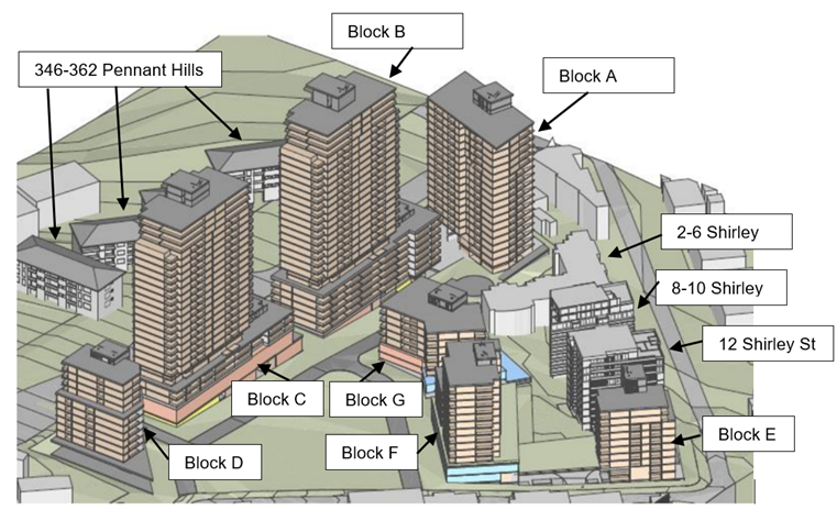
Figure 5 - Location of Adjoining Properties and Proposed Scheme
62. The owner of a unit that will be built at 12 Shirley Street (See Figure 5) has raised concerns regarding overshadowing and reduced privacy as a result of the proposed location of Block E to the north of that property.
|
|
|
|
Figure 6 – Current zoning configuration |
Figure 7 – Proposed zoning configuration |
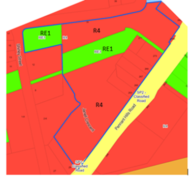
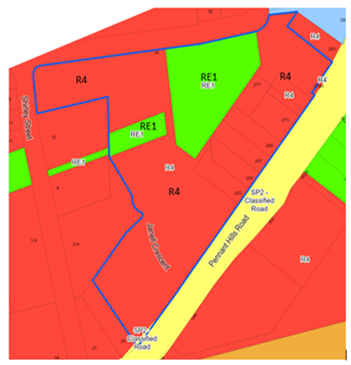
63. The Applicant’s overshadowing analysis indicates that when factoring in the previously approved Development Application, 93% of the apartments to be built on 12 Shirley Street meet ADG solar access design guidelines which require that developments achieve a minimum of 50% direct sunlight to the principal usable part of the communal open space for a minimum of 2 hours between 9 am and 3 pm on 21 June and also living rooms and private open spaces of at least 70% of apartments in a building receive 2 hours direct sunlight between 9 am and 3 pm on 21 June. The Applicant’s overshadowing modelling indicates that following development of the Planning Proposal scheme, this figure would fall by 7% to 86% and as such, is consistent with the ADG requirements.
64. A submission made has also raised the potential impact of the new development on solar collectors that are provided as part of the 12 Shirley Street development. Verification submitted by the Applicant has established that the development facilitated by the Planning Proposal would meet the relevant ADG design guidance of a minimum of four hours solar access to solar collectors.
65. No. 8-10 Shirley Street, to the west of the subject site (see Figure 5) accommodates a 10 storey residential flat building that is currently under construction. The Applicant’s solar analysis establishes that 98% of apartments within this building will receive two hours of direct solar access during mid-winter when factoring in the previously approved Development Application which is exceeds the minimum 70% requirement of the ADG.
66. The Applicant’s overshadowing information indicates that the development facilitated by the Planning Proposal will have the effect of reducing ADG compliance for 8-10 Shirley Street to 79% which still exceeds the 70% ADG requirement.
67. It should be noted that this property is impacted by proposed Block G which is within the existing 33m maximum Height of Building Control in Parramatta LEP 2023.The proposed Maximum Height of Building control for Block G will be reduced from 56m to 33m.
68. The Applicant’s solar analysis verification for 8-10 Shirley Street also indicates that the proposal satisfies the ADG requirement of a minimum of four hours solar access to solar collectors in mid-winter.
69. No. 2-6 Shirley Street, located to the west of the subject site (See Figure 5), contains a four storey residential flat building. The Applicant’s analysis shows that the development to be facilitated by the Planning Proposal will overshadow this property. This property would already be overshadowed by the previously approved development for the subject site. It should also be noted that under the proposed scheme this property would be impacted by proposed Block G which will remain within the existing 33m maximum height of building control under Parramatta LEP 2023. Analysis of overshadowing impacts including on solar collectors will be further addressed at the Development Application stage.
70. The Applicant‘s overshadowing analysis for 346-362 Pennant Hills Road, opposite the subject site, indicates that whilst the development facilitated by the Planning Proposal would increase overshadowing by 17% in midwinter, this is below the 20% maximum additional overshadowing prescribed by the ADG.
71. In relation to potential privacy impacts on surrounding properties, the building envelopes have been designed to minimise adverse privacy impacts on neighbouring properties and to allow for appropriate building orientation and separation. The future Development Application for the site and must comply with the mandatory separation distances prescribed in the ADG. Further, the Applicant has demonstrated that the proposal can satisfy the visual privacy objectives of the ADG, although these will be assessed at the Development Application stage of the proposal.
72. The proposal focuses the greatest building height on Pennant Hills Road. The concentration of the height on Pennant Hills Road is consistent with existing DCP controls that require more substantial buildings on this frontage.
73. In order to reduce visual impact, the SSDCP for the site includes a range of objectives and controls to encourage buildings to respond to the local context including envelope controls and building form controls with:
a. Objectives that encourage buildings to respond to the local context including adjoining properties.
b. Minimum podium and tower setbacks.
c. Controls to guide building form.
d. Controls to guide building materials.
74. In order to provide further control and certainty on the impacts of the new apartment buildings, and noting that the Applicant has demonstrated that the proposed scheme complies with overshadowing requirements of the ADG, it is recommended that the exhibited maximum Height of Building controls (Figure 8) be reduced to align more closely with the proposed reference scheme for Buildings A, D, E, F and G (See Figures 5 & 9).
|
|
|
|
Figure 8 – Exhibited HoB Map |
Figure 9 – Proposed HoB Map |
75. Whilst it is considered that the proposed revised and reduced Height of Building controls will ensure a suitable form of development in this location, it should also be noted that the Minister’s letter to Council concerning the housing crisis (see Attachment 6) asks Councils to prioritise the opportunity to deliver homes as part of merit considerations where, on balance, dwelling numbers may warrant a scale or built form that is different to or greater than the outcome originally anticipated.
Council Officer Recommendation
76. Amend the proposed maximum Height of Building Map in accordance with Figure 9.
(e) Proposed Provision of Local Infrastructure
77. Several submissions suggested that the associated proposed
local infrastructure, in particular the proposed community hub is not needed.
Council Officer Response
78. The provision of community facilities is an important consideration in the strategic planning for a growing community. The Parramatta Community Infrastructure Strategy 2020 (CIS) identifies that the Carlingford community is set to experience significant growth in population as a result of increasing high density development, and that this growth will impact the immediate area surrounding Carlingford Library and will place an even greater demand on that library service, which is already operating above capacity.
79. The CIS and the Parramatta Outside of CBD Development Contributions Plan recommend that Carlingford Library is redeveloped into a larger facility of 1,800m2, located within a new community hub in Carlingford close by to public transport, ideally the future light rail stop as well as an additional 800sq.m community space.
80. Staff research into alternative sites for a Community Hub indicated that the subject site is the most appropriate and available site for this community infrastructure, with no alternative sites available.
Council Officer Recommendation
81. No change to proposed infrastructure provision.
Overall Council Officer Recommendation
82. Council officers acknowledge the large response to the subject Planning Proposal and the variety of views expressed by the stakeholders engaged.
83. Whilst acknowledging the objections and concerns raised, Council officers consider that the issues raised in the exhibition responses have, where appropriate, been addressed by the Planning Proposal and supporting documentation and, with the minor amendments recommended, that the Planning Proposal, DCP and Planning Agreement should proceed to finalisation.
AGENCY SUBMISSIONS
84. A total of three agencies were notified of the public exhibition of the proposal, with one submission received from TfNSW at the time of writing this report. A summary of the issues raised in this submission, which does not raise any objection to the proposal, is provided below, with further detail provided in Attachment 3. Responses are awaited from SINSW and DPHI – Crown Lands and details of submissions received prior to the LPP meeting will be advised at the meeting.
Transport for NSW
85. The submission from TfNSW advises that the proposed uplift necessitates the signalisation of the Evans Road/Lloyds Avenue/Pennant Hills Road intersection in order to provide safe pedestrian access to the southern side of Pennant Hills Road.
86. TfNSW also advises Council that the agency has been liaising with the DPHI on the potential to deliver this signalisation as ‘works in kind’ and for these works to be credited against the Housing and Productivity Contribution levies applicable to the proposed development. DPHI have put forward suggested potential pathways to TfNSW on how this funding mechanism can be secured, which the agency is actively pursuing.
87. TfNSW will continue working with the Applicant, DPHI and Council to ensure the delivery of this intersection upgrade is undertaken to ensure the success of the travel demand management associated with the proposed development, pedestrian safety, and improved road safety outcomes for the wider community.
88. TfNSW also recommends that as part of any future Development Application (DA) for the site, the Applicant engages with TfNSW regarding the status of the proposed works as some interim measures may need to be implemented by the development to ensure pedestrian safety of future users of the development.
89. TfNSW has no objection to the proposed amended carparking rates referred to earlier in this report.
PROPOSED CHANGES TO THE DRAFT DCP
90. In response to issues raised during the exhibition process and further review of the draft DCP, several changes post-exhibition are proposed to be made to ensure the intended development outcomes can be achieved on the site.
91. The changes range from rewording of some controls to reflect their initial intent to provide clarification, typographical correction, consolidation of section, and removal of text to prevent duplication with the existing controls of Parramatta DCP 2023. Refer to Table 6 for a list of key changes. These changes are not considered to be of a nature that require the draft DCP to be re-exhibited.
Table 6 – Key Changes to the draft DCP
|
Section |
Changes between the version reported pre-Gateway and exhibition |
Proposed Changes post-exhibition |
|
Introduction |
· Insertion of text clarifying the application of the controls and the controls in Parramatta DCP 2023. · Rewording of and deleting/adding various objectives and controls. · Additional wording to describe and add objectives regarding the desired future character and design quality. · Removal of wording in relation to application of DCP and consistency with objectives and controls. · Consolidating the general objectives into the introduction. |
· No changes proposed |
|
Built form |
· Rewording of and deleting/adding various objectives and controls including. · Podium setback controls: o Front boundary setback to Pennant Hills Road: 10m o Shirley Street northern frontage setback: 6m o Internal roadways setback 4m o Through site links 0m setback · Upper Level Setbacks: o Buildings fronting Pennant Hills Road, internal streets and the Central Park (buildings A-F): 2m o North Eastern edge of buildings B and C: 4m o Community Link between buildings E and F: 3m o Southern edge of building D: 2m o Buildings fronting Shirley Street (E-F): 3m · Addition of controls to prevent undercrofts. · Consolidating/refining objectives and controls related to site structure, setbacks, building height, building separation, building location, non-residential uses, community facility and library, building material and design into the built form section. · Addition of new sub-sections with objectives and controls related to retail ground floor frontage, residential ground floor frontage, residential design apartment quality, winter gardens and retaining walls. |
Amending setbacks including: · Podium setback: o Shirley Street northern frontage setback reduced to 4m with an additional 3m required between podiums. · Upper level setbacks: o Buildings fronting Shirley Street (E-F): reduced from 3m to 2m. · Insertion of new control to require a consistent podium datum zone. · Amending control regarding building steps to be permitted where ADG satisfaction required. · Remove controls preventing undercrofts. · Amendment of building design control regarding stepping in the built form to allow for more than one step if required to satisfy ADG and ensure solar access to adjoining properties.
|
|
Floor to Floor Heights |
· Insert minimum community facility floor to floor heights of 4.5m for ground floor and 4m above. |
· Amend minimum community facility floor to heights from 4.5m on ground and 4m above to 4.5m on ground and 3.8m above and below. |
|
Water Management |
· NA - existing Parramatta DCP 2023 controls. |
· Introduction of a new Water Management section with objectives and controls to address overland flow. |
|
Public Domain |
· Rewording of and deleting/adding various objectives and controls. · Addition of new subsection related to active transport to facilitate a cycleway through the site and along Pennant Hills Road. · Addition of new subsection related to street network and footpaths. · Addition of new subsection related to Communal Open Space. · Addition of new subsection related to overhead powerlines. · Addition of new subsection related to awnings and awning design. · Consolidation of landscaping objectives controls into public domain section. |
· Renumbering and rewording of controls and objectives for clarity. · Amendment of control relating to Road widening to of Shirley Street only relates to the south site. · Amendment of indicative road network image to show pedestrian connections. · Amendment to the Public Open Space Plan to identify that the Public Open Space east-west link to Shirley Street will be dedicated to Council. · Removal of the control that that refers to an easement being provided for the east-west link. |
|
Vehicle Access and Parking |
· Rewording and addition/deletion of various objectives and controls. · Reduced residential parking rate to align with existing DCP. · Reduced retail parking rate to align with existing DCP. · Addition of parking rate for 4-bedroom units. · Addition of bicycle parking subsection. · Addition of control requiring widening of Shirley Street. |
· Updating of residential parking rates as discussed earlier in this report. · Addition of a parking rate for the supermarket. |
|
Sustainability |
· Addition of one objective in relation to electric vehicle car charging. · Deletion of control related to an ESD report guiding development on the site. · Extension of one control in relation to water re-use system for irrigation systems. |
· No changes proposed |
|
Urban Heat Island |
· New section with objectives and controls relating to vertical facades and awnings. |
· No changes proposed |
|
Public Art |
· No changes proposed |
· No changes proposed |
92. Proposed changes were undertaken in consultation with the Applicant and involved detailed input from Council technical officers. Some further refinements to the DCP provisions are still being considered and these will be addressed in detail in the report to Council seeking to progress this matter to finalisation. These further refinements if required will not have a material impact on the content of the Planning Proposal and recommendation of this report.
FINANCIAL IMPLICATIONS FOR COUNCIL
93. Any work to progress the finalisation of the Planning Proposal would be prepared by Council officers and therefore within the existing City Planning and Design budget. Should this matter progress, a Planning Agreement delivering the public benefits outlined in this report will be entered into between Council and the applicant.
CONCLUSION AND NEXT STEPS
94. It is recommended that the Local Planning Panel support the Council Officer recommendation for Council to approve the finalisation of the Planning Proposal provided at Attachment 1.
95. Following Local Planning Panel consideration of the recommendations of this report, the outcomes of the public exhibition of the Planning Proposal, DCP and Draft Planning Agreement will be reported to an upcoming Council meeting for endorsement.
David Birds
Group Manager, Major Projects and Precincts
Jennifer Concato
Executive Director City Planning and Design
|
Planning Proposal and Appendices (under separate cover) |
914 Pages |
|
|
|
Draft Site-Specific Development Control Plan (under separate cover) |
34 Pages |
|
|
|
Community Engagement Report (under separate cover) |
86 Pages |
|
|
|
Gateway Determination (under separate cover) |
2 Pages |
|
|
|
Site History (under separate cover) |
4 Pages |
|
|
|
Letter from the Minister of Planning & Public Spaces about the Housing Crisis (under separate cover) |
2 Pages |
|