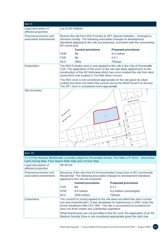
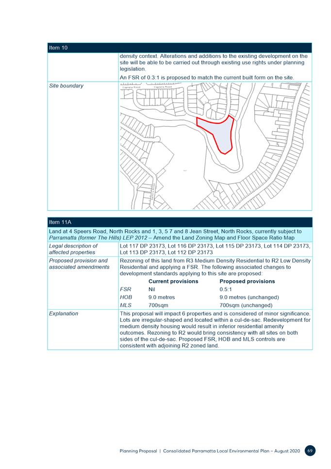
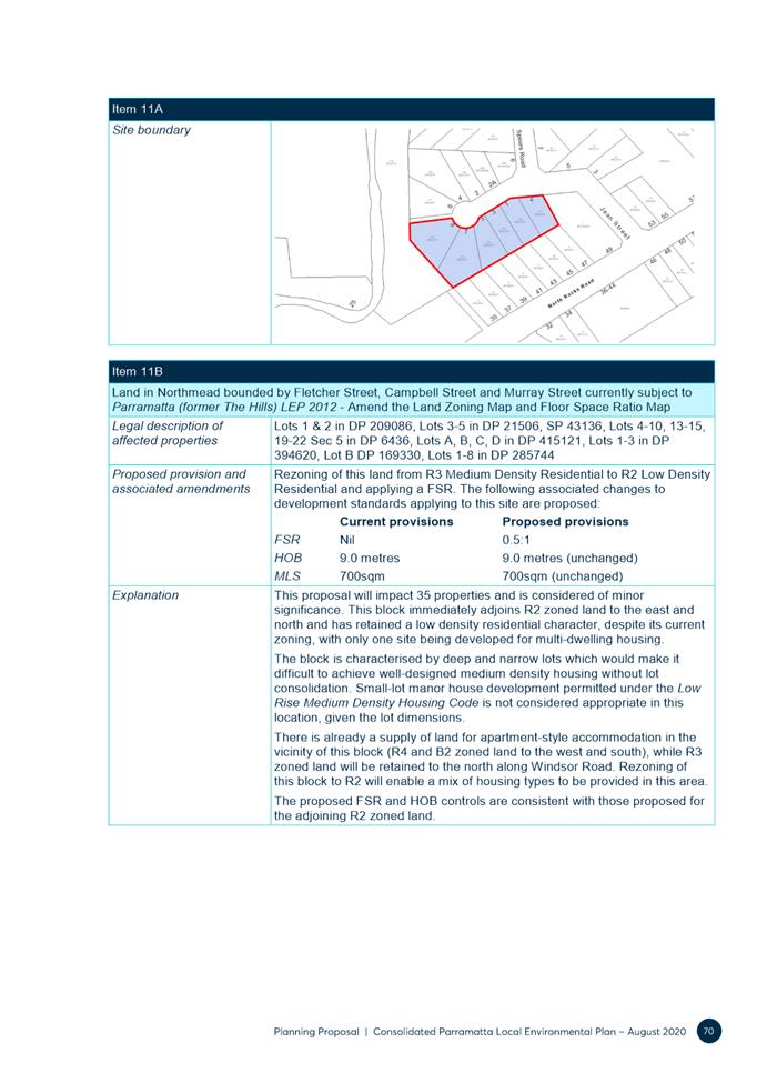
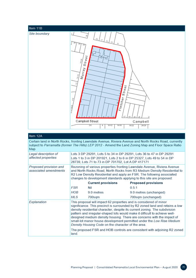
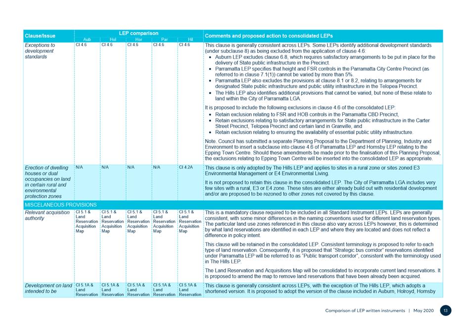
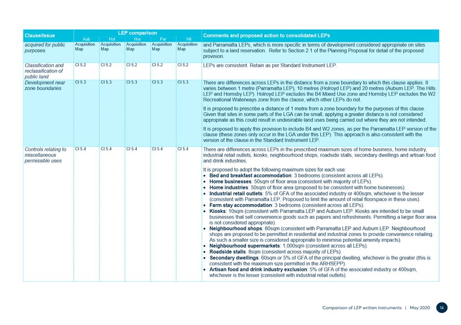
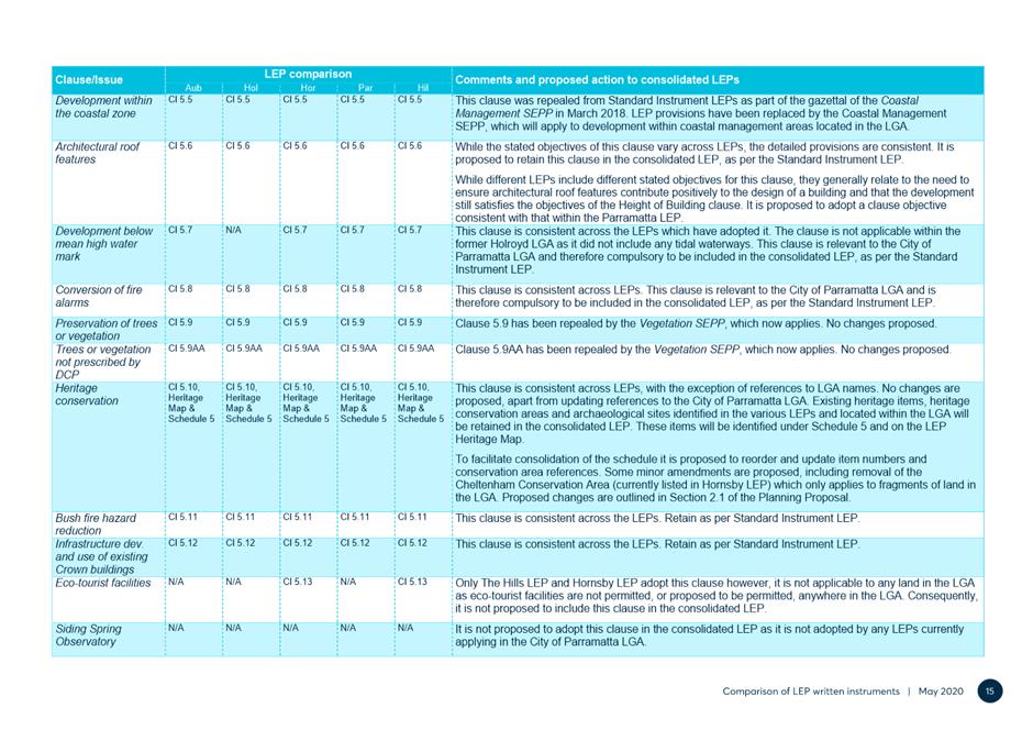
Local Planning Panel 29 June 2021 Item 5.1
ITEM NUMBER 5.1
SUBJECT PUBLIC MEETING: Post Exhibition - Harmonisation Planning Proposal - Consolidated City of Parramatta Council Local Environmental Plan
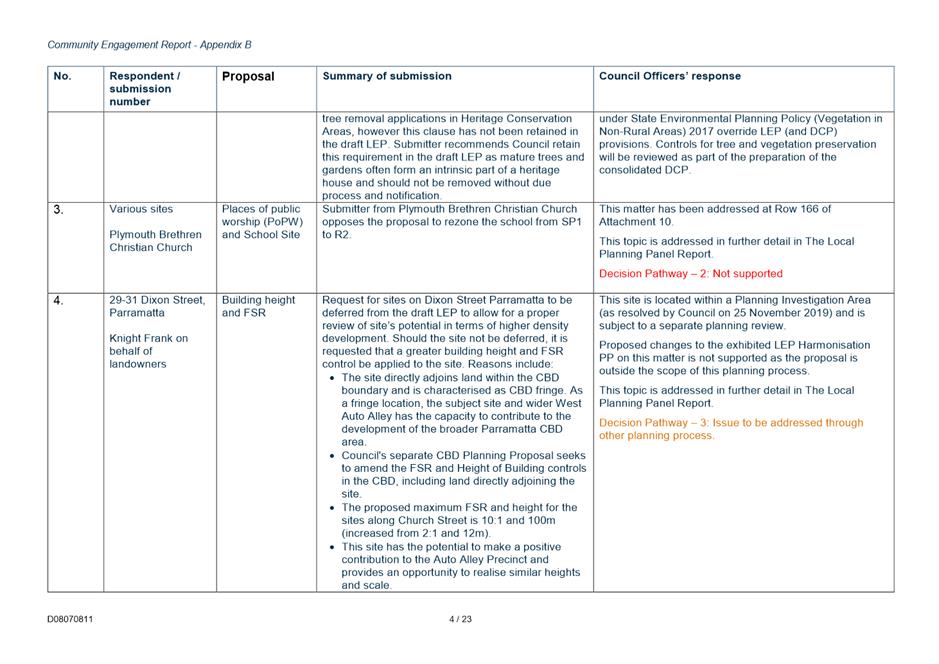
REFERENCE F2020/02092 -
APPLICANT/S City of Parramatta
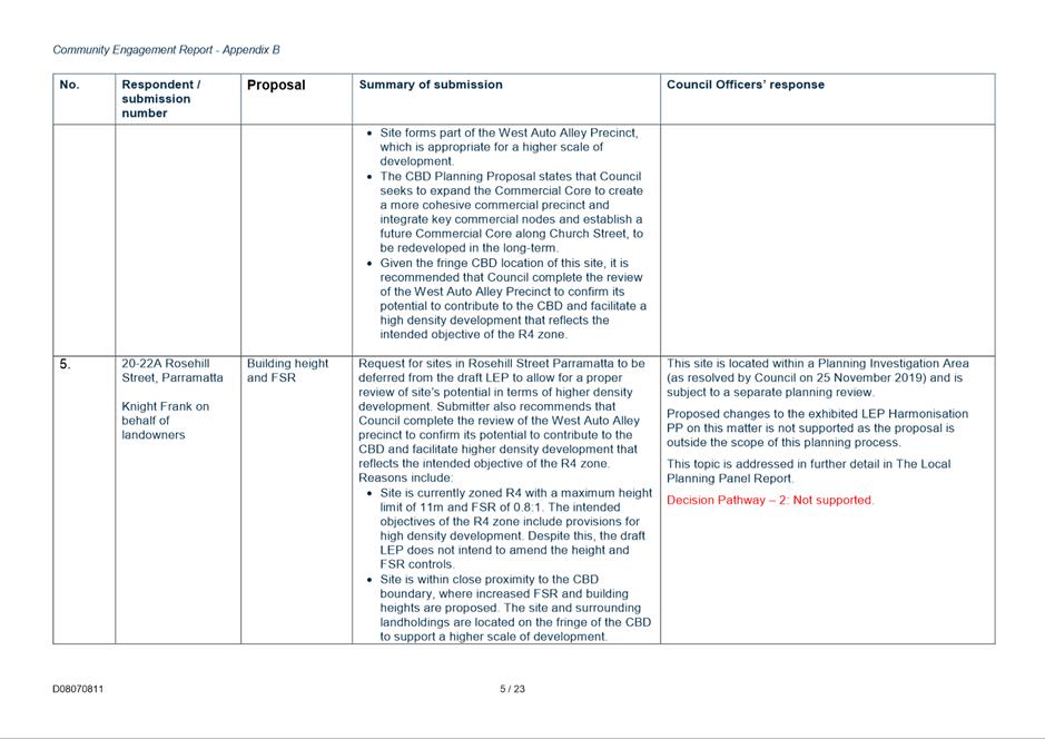
OWNERS LEP Consolidation
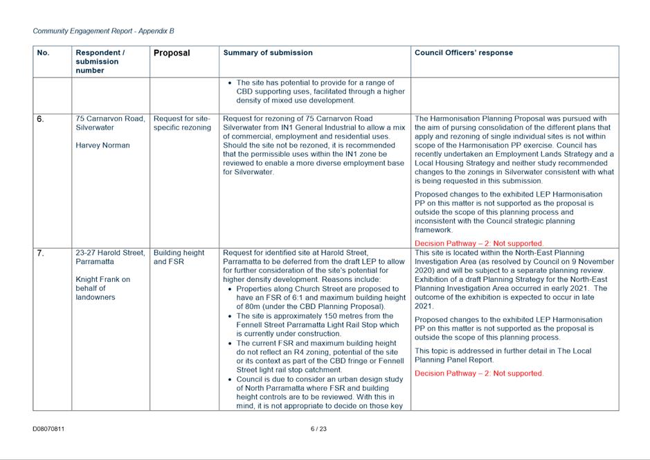
REPORT OF Land Use Planning Manager
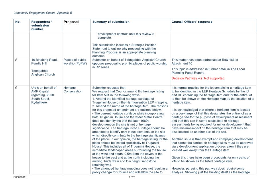
The Local Planning Panel recommend to Council:
(a) That Council note the submissions made in response to the public exhibition of the Parramatta Harmonisation Planning Proposal (Harmonisation PP) as summarised at 9 to 12 including the Council officer responses.
(b) That Council endorse for the purpose of finalisation the content of the exhibited Harmonisation PP subject to the amendments described in this report which are detailed in Attachment 13 (identified as ‘Changes that are supported (via Decision Pathway 1 - Green)’).
(d) That Council forward the Harmonisation PP to the Department of Planning, Industry and Environment (DPIE) for finalisation, with a request that the amendment be made in accordance with section 3.36 of the Environmental Planning and Assessment Act 1979.
(e) That Council:
i. Note the requested changes to the Harmonisation PP summarised in Attachment 13, which are recommended not to be supported (identified as ‘Changes that are not supported (via Decision Pathway 2 - Red)’);
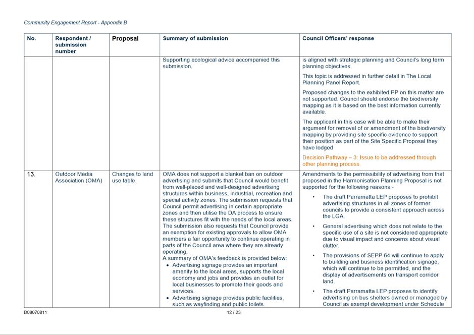
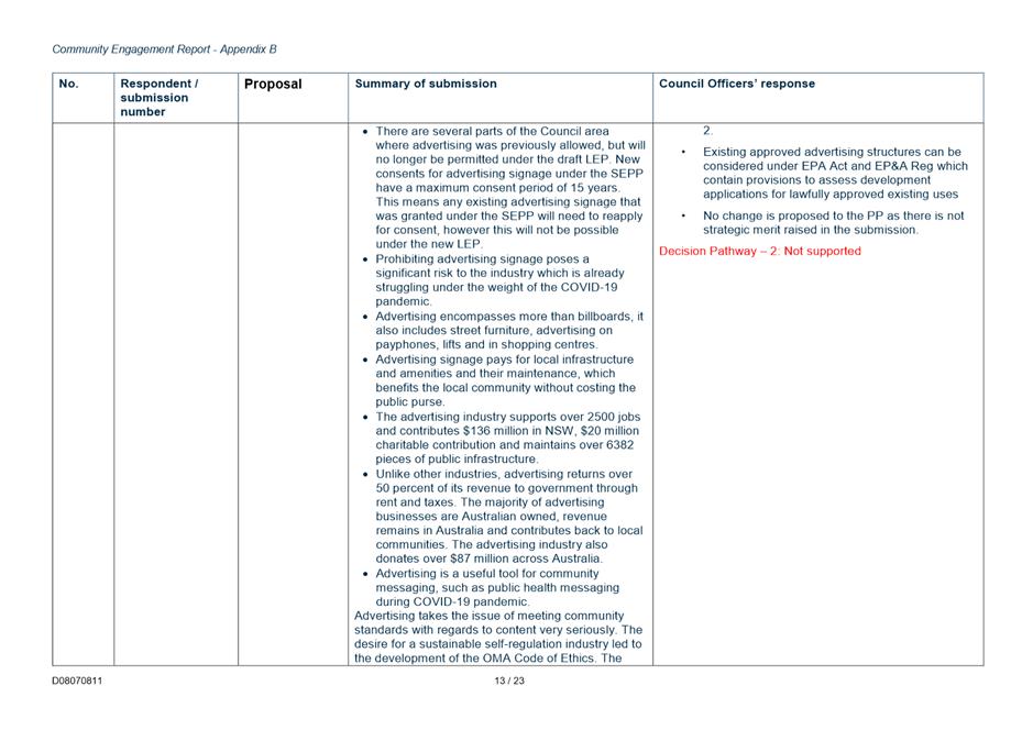
ii. Support further investigation of the matters set out in Attachment 13 (identified as ‘Changes that have merit for further investigation (via Decision Pathway 3 - Orange)’).
(f) That Council delegate authority to the Chief Executive Officer to make any minor amendments and corrections of a non-policy and administrative nature that may arise during the plan amendment process relating to the Harmonisation PP (and supporting documentation), Draft PLEP 2021 Amendment Instrument and Draft PLEP 2021 Amendment Maps. This includes the updating of property information for existing Heritage Items and existing Heritage Conservation Areas in Schedule 5 of the DPLEP.
(i) Further, that all submitters be notified of Council’s decision to endorse the amended Parramatta Harmonisation Planning Proposal (Harmonisation PP).
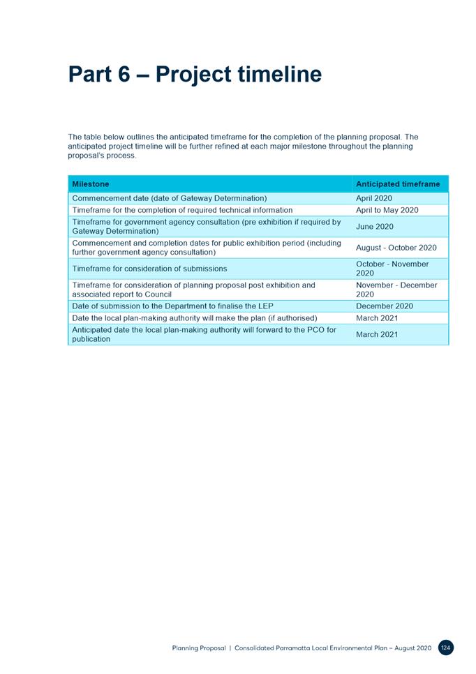
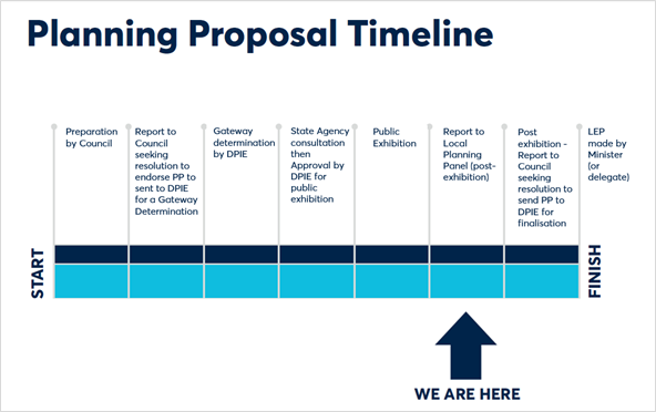
PLANNING PROPOSAL TIMELINE
SUMMARY
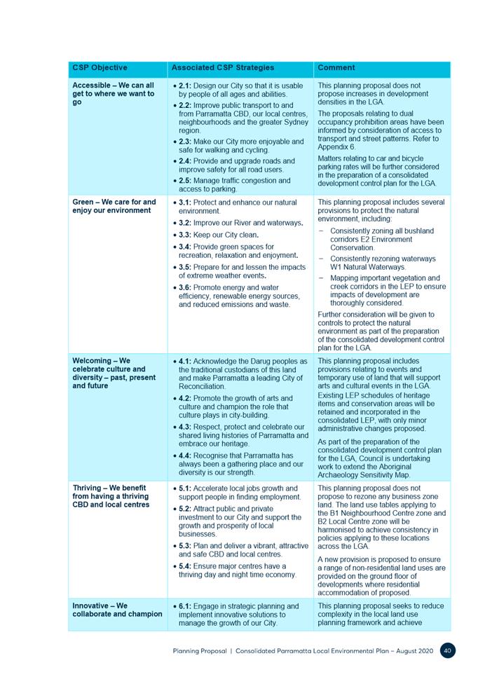
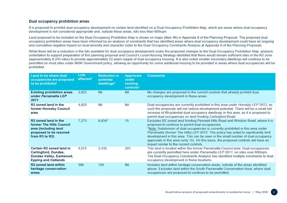
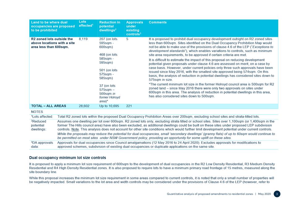
1. Arising from the 2016 amalgamations, the current City of Parramatta Local Government Area (LGA) was formed from parts of the previous councils of the City of Parramatta, Holroyd, The Hills, Hornsby and Auburn. The current LGA has an area of 84 square kilometres and an estimated population of 260,296 (Source: City of Parramatta Community Profile, 2020).
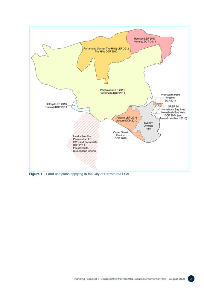
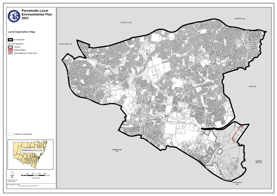
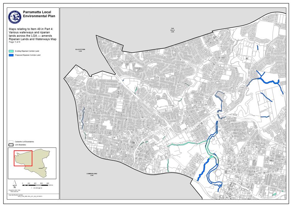
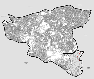
2. A map showing the current City of Parramatta boundary (and former LGA‘s) is shown at Figure 1.
Figure 1 - Map showing the City of Parramatta boundary.
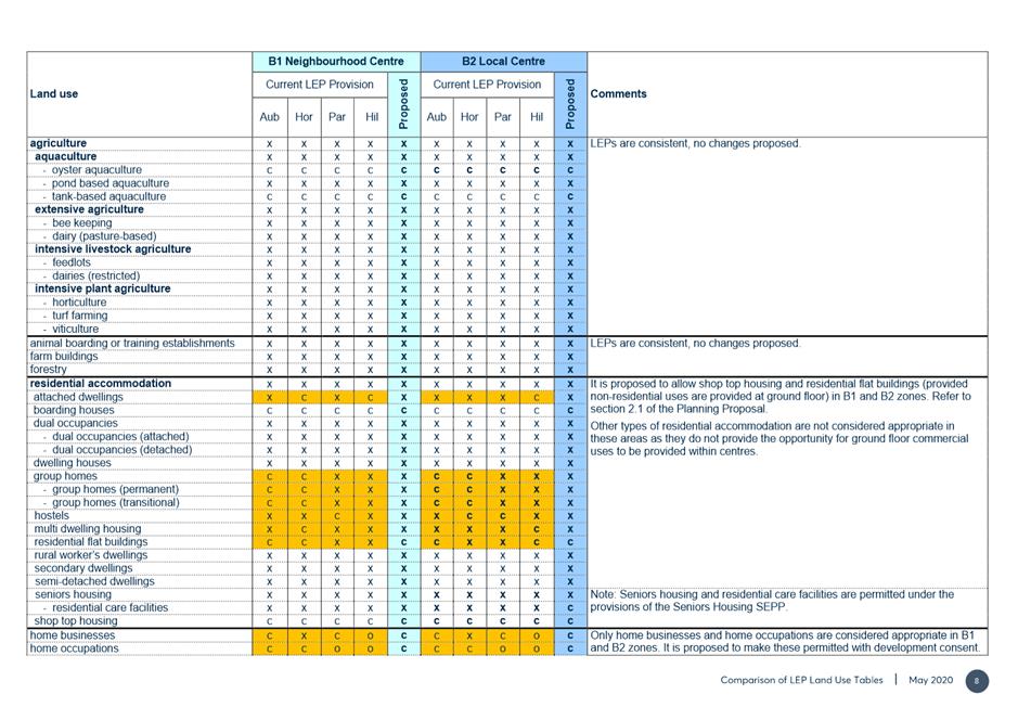
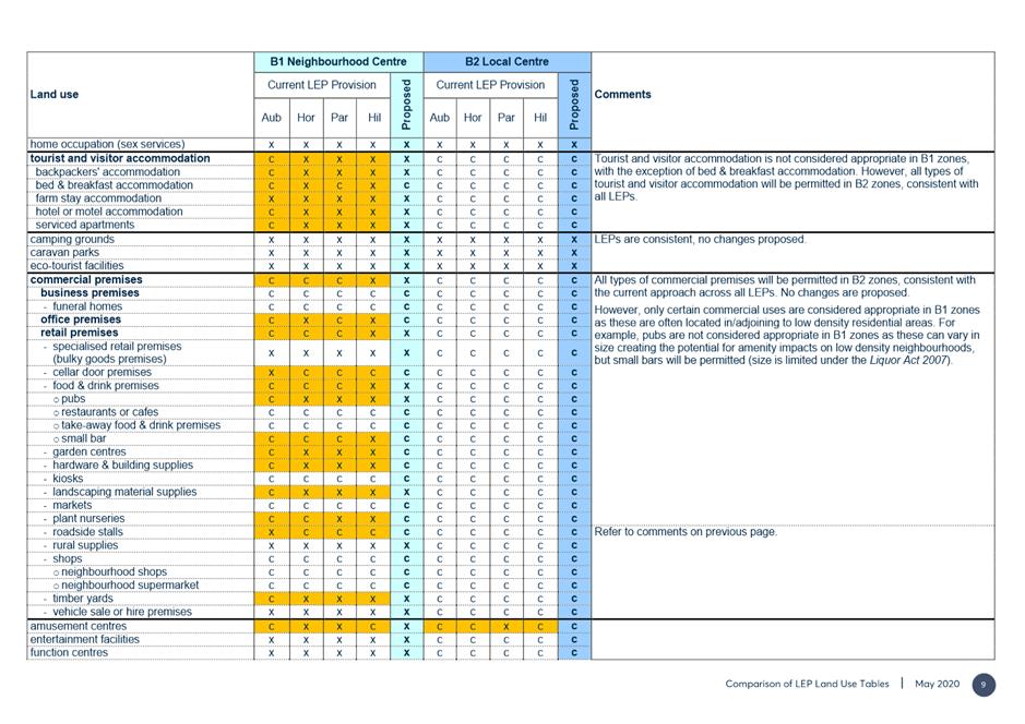
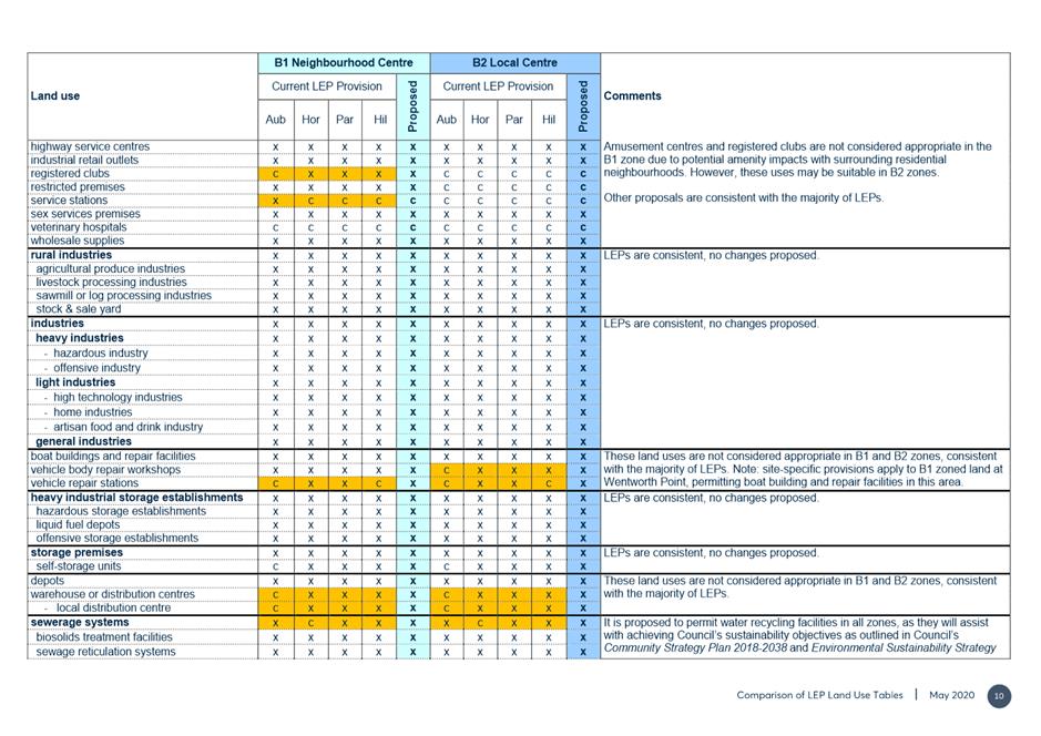
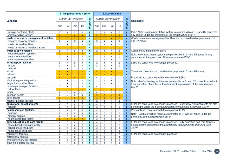
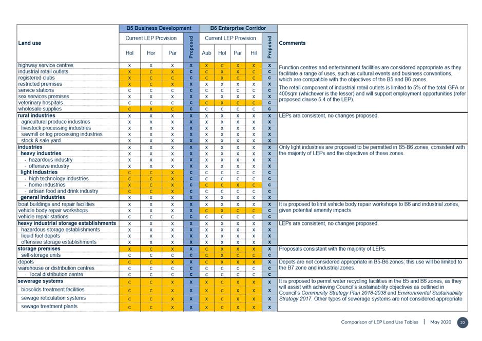
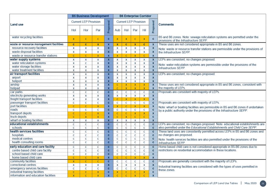
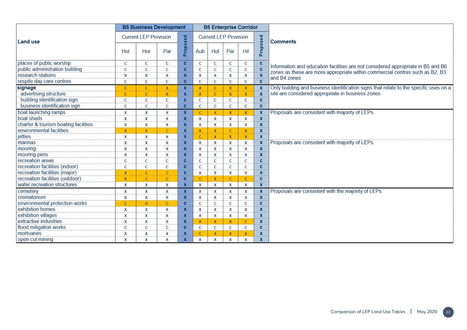
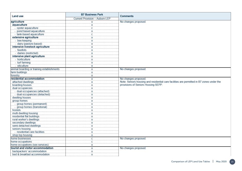
3. This report details the outcomes from the public exhibition of the Parramatta Harmonisation Planning Proposal (Harmonisation PP) and seeks Council endorsement of a revised planning proposal amending the Parramatta Local Environmental Plan 2011 (PLEP 2011), Hornsby Local Environmental Plan 2013 (HYLEP 2013), Holroyd Local Environmental Plan (HLEP 2013), The Hills Local Environmental Plan 2013 (THLEP 2013) and Auburn Local Environmental Plan (ALEP 2011) as they apply to the current Parramatta LGA boundary. The endorsement is to permit the plan to be forwarded to the Department of Planning, Industry and Environment (DPIE) for finalisation.
4. Having considered the submissions received, it is proposed to progress the exhibited Harmonisation PP and draft PLEP with only minor amendments.
5. In finalising the Harmonisation PP, Council’s policy direction for the “new” Parramatta LGA will be clearer, and together with the upcoming Harmonisation DCP, will seek to deliver on the LSPS intention to: “improve the development application assessment process and provide a level of consistency in the planning framework” in the LGA for stakeholders (p.24 LSPS). A single LEP will enable a platform for future planning change consistent with long term strategic directions. The future one Parramatta DCP will harmonise the nine DCPs that currently apply in the LGA, will complement the provisions in the new, harmonised LEP for the City of Parramatta and will create a clear set of development controls.
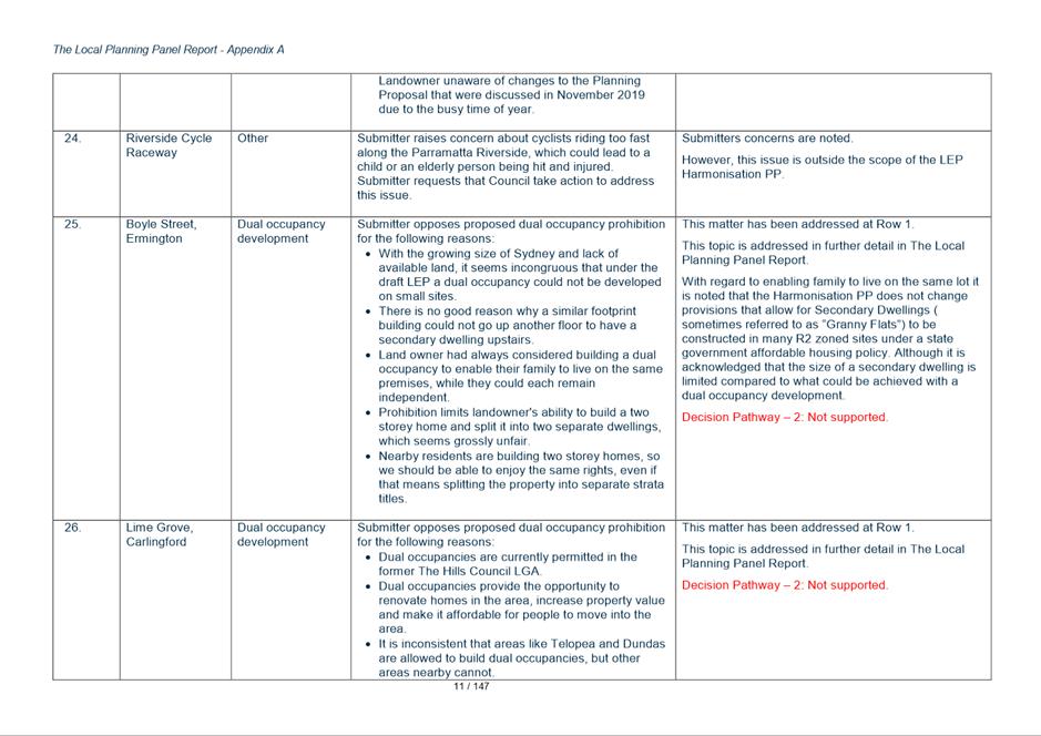
BACKGROUND
6. Table 1 below outlines a chronology of key actions that Council has taken to progress the Harmonisation PP and draft PLEP.
Table 1 – Key actions related to the Harmonisation PP and draft PLEP
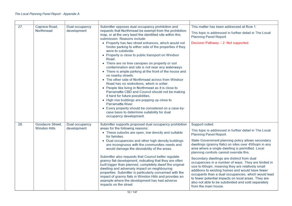
|
DATE |
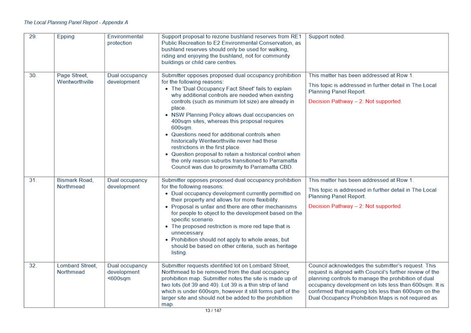
EVENT |
|
12 May 2016 |
Local Government (City of Parramatta and Cumberland) Proclamation was notified. This resulted in the creation of the new City of Parramatta Council LGA, from parts of the former Auburn, Holroyd, Hornsby, Parramatta and The Hills councils. This triggered the need for a consolidated LEP for the new LGA. |
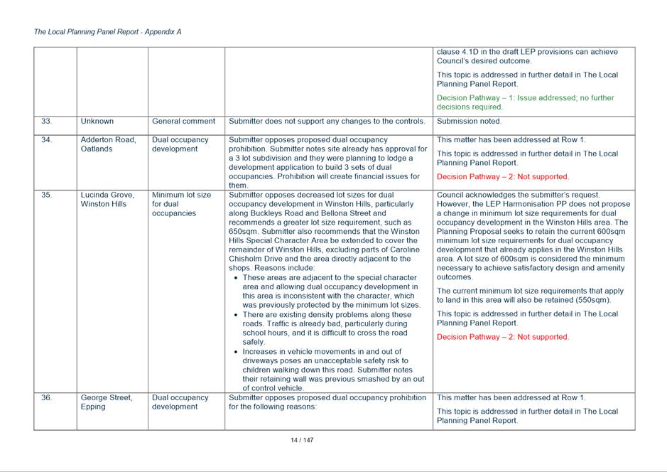
|
November 2017 to May 2018 |
Preparation of Land Use Planning Harmonisation Discussion Paper. A total of 7 Councillor Workshops were held. |
|
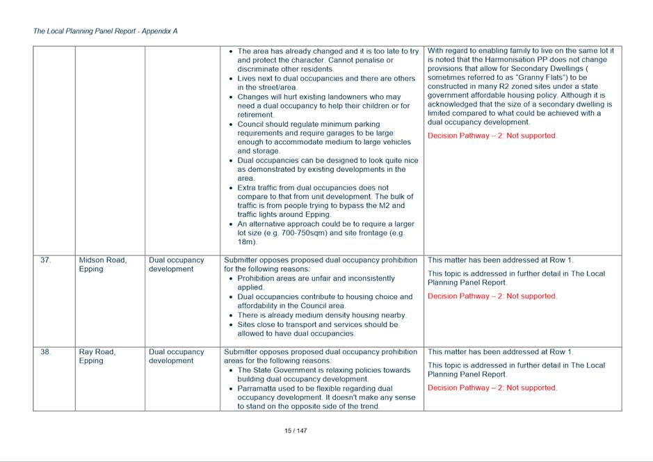
21 November 2018 |
Councillor Workshop on Discussion Paper. |
|
26 November 2018 |
Council endorsed the Discussion Paper. |
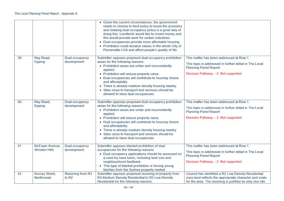
|
21 January – 4 March 2019 |
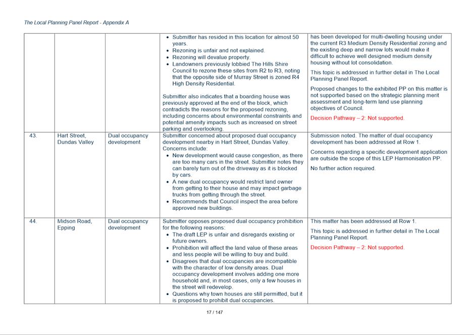
Exhibition of Land Use Planning Harmonisation Discussion Paper (Discussion Paper). A total of 539 submissions were received (222 written and 317 survey responses). |
|
April 2019 |
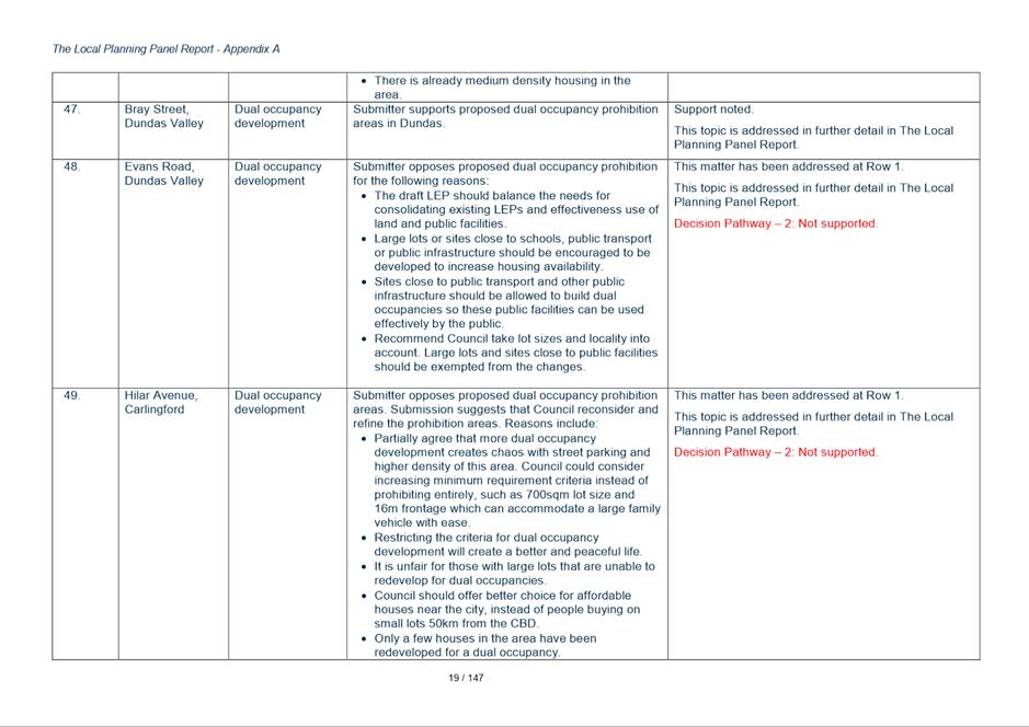
Council officers reviewed feedback on Land Use Planning Harmonisation Discussion paper. |
|
15 July 2019 |
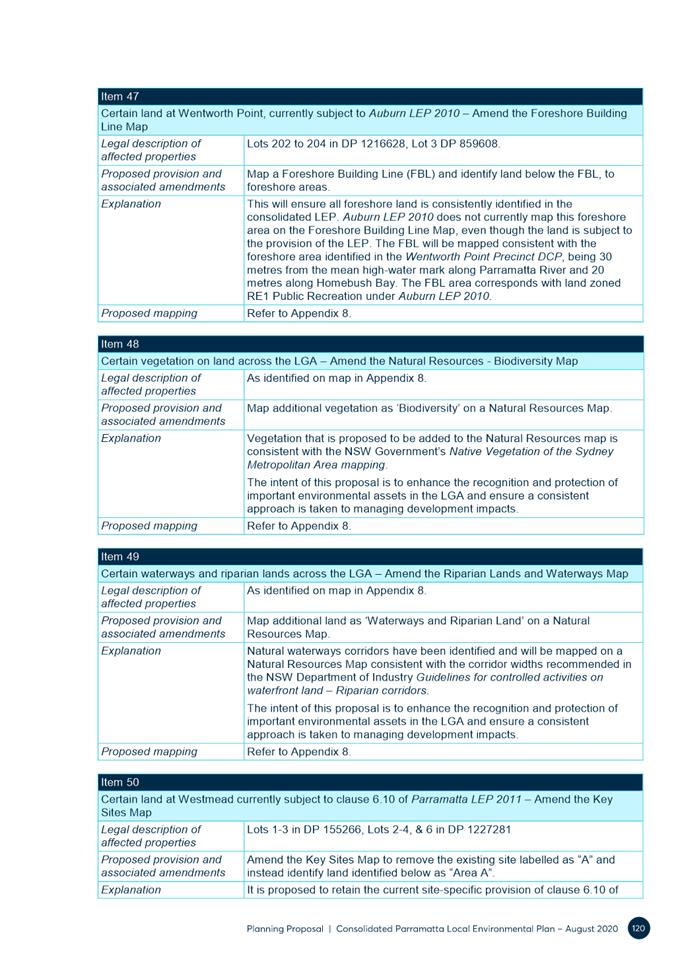
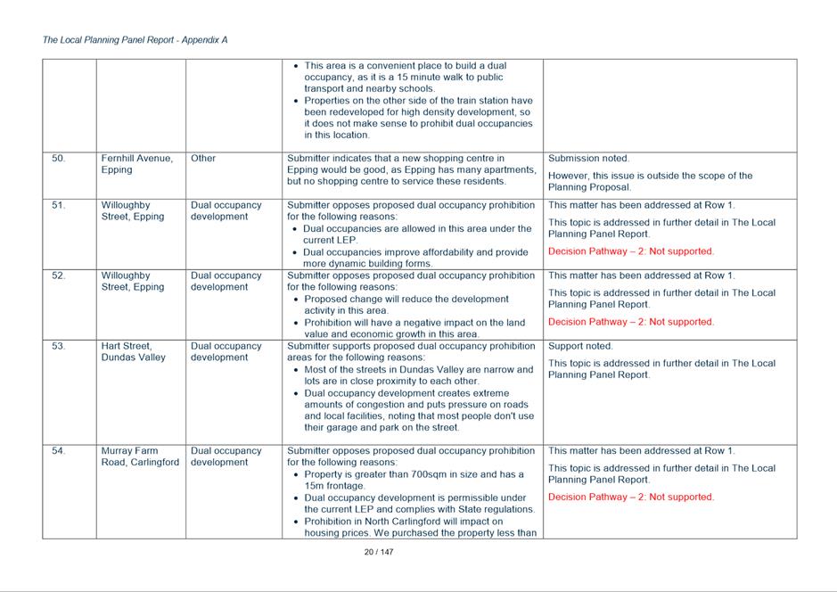
Councillor Briefing/Workshop on Discussion Paper exhibition. Councillors raised concerns with the impacts of dual occupancies on local areas, particularly in relation to parking and traffic issues associated with dual occupancy development on narrow roads. Concerns were also raised of impacts on local character. The feedback received from Councillors has informed the preparation of the planning proposal. |
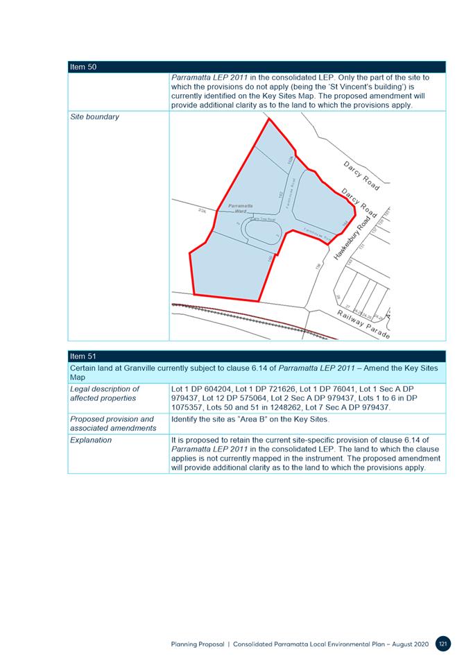
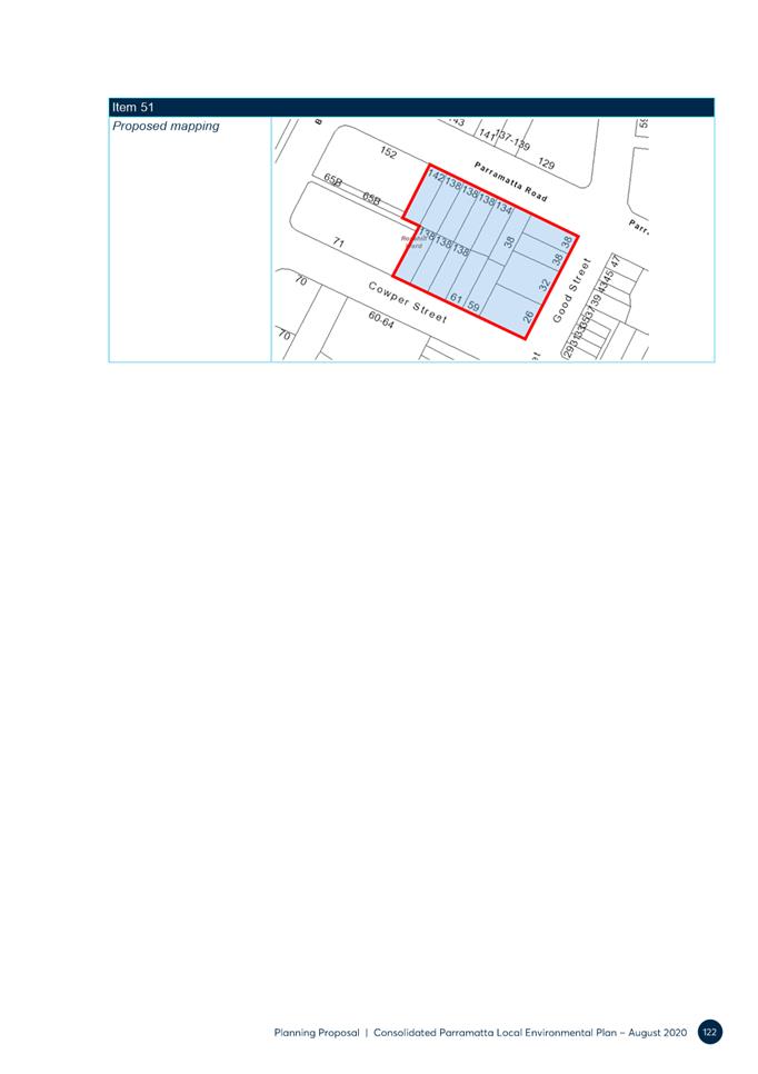
|
8 October 2019 |
Local Planning Panel (LPP) considered a report on the PP. LPP endorsed the officer recommendation, with 2 additional recommendations. The Panel’s subsequent advice to Council was consistent with the Council officer’s recommendation, i.e.that the dual occupancy prohibition areas not be further extended. The Panel also asked that there be greater targeted public consultation regarding dual occupancy (including the constraints analysis). |
|
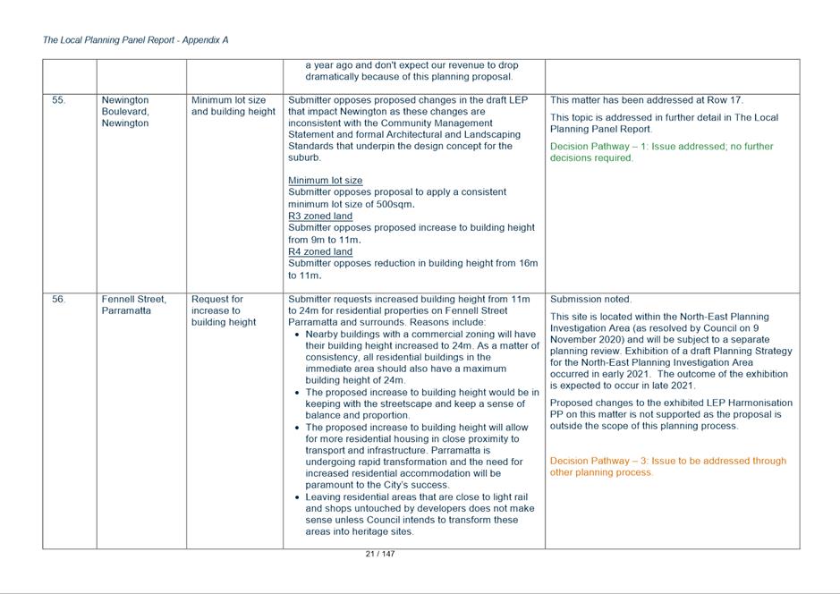
6 November 2019 |
Councillor Workshop Pre-Briefing |
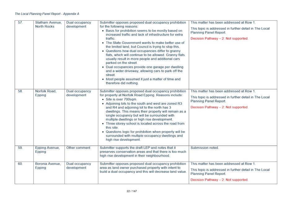
|
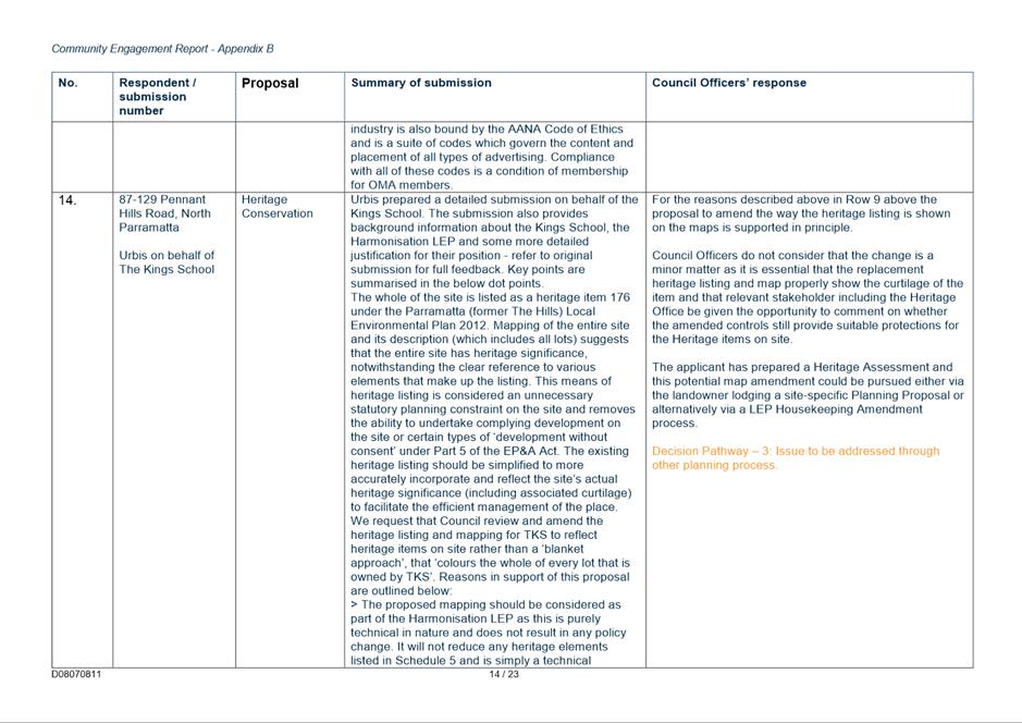
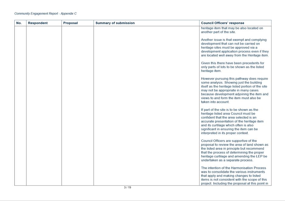
11 November 2019
|
Council considered a report on the Harmonisation Planning Proposal. It resolved to endorse a Planning Proposal to send to DPIE for a Gateway Determination. |
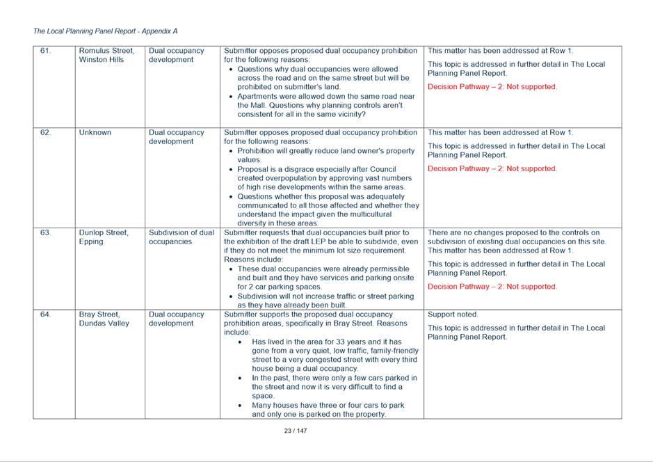
|
13 December 2019 |
Amended Harmonisation Planning Proposal (PP) – Consolidated City of Parramatta Local Environmental Plan (LEP) sent to DPIE for a Gateway Determination. |
|
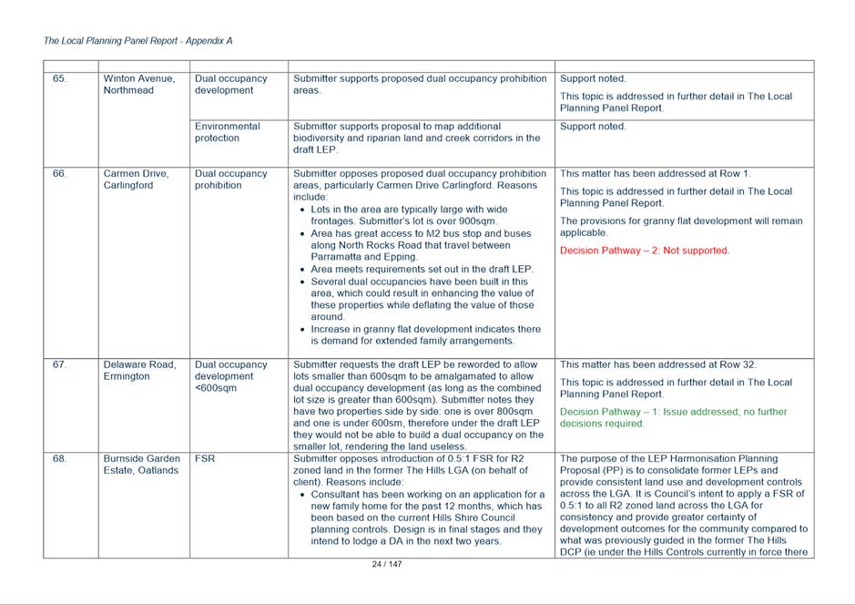
16 April 2020 |
DPIE issued a Gateway Determination to proceed to public exhibition (with some amendments). |
|
31 August 2020 to 12 October 2020 |
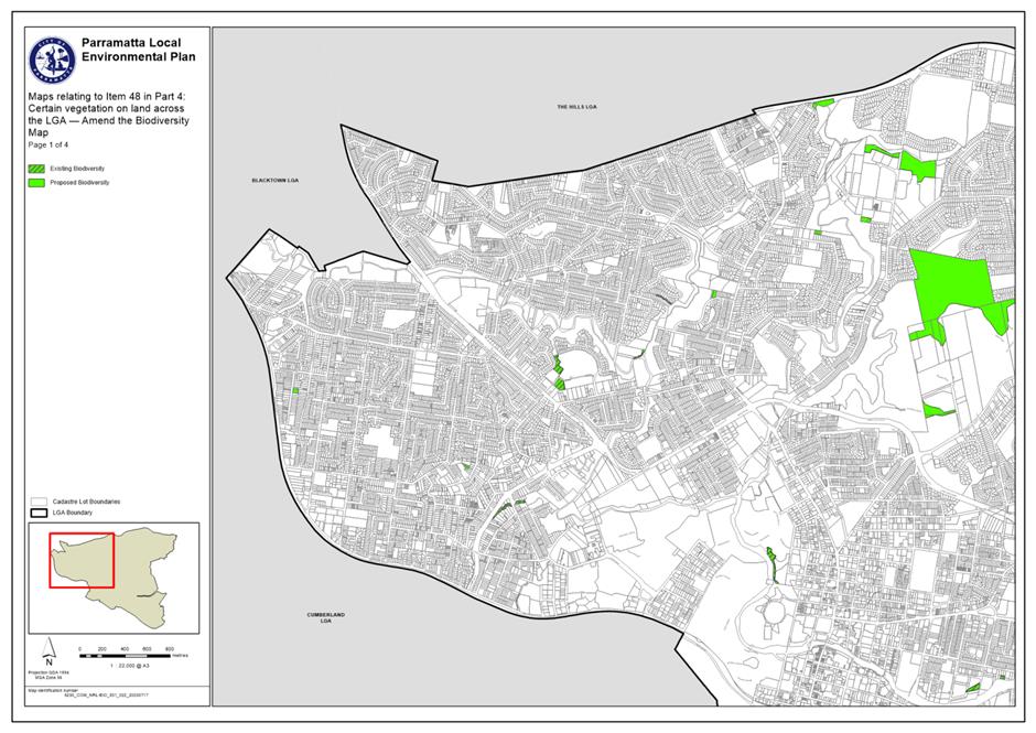
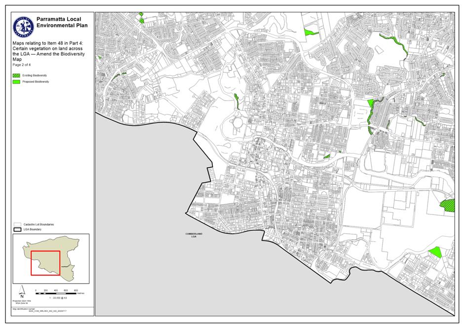
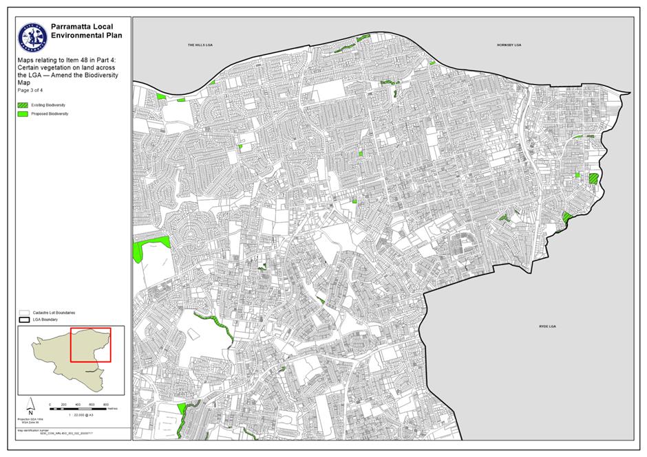
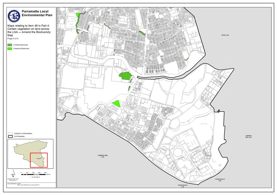
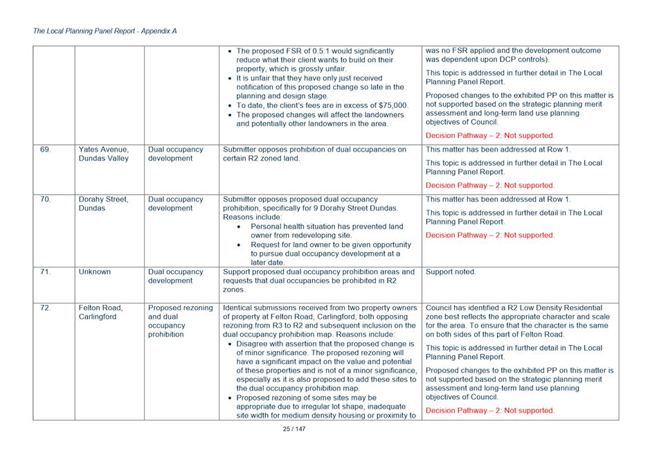
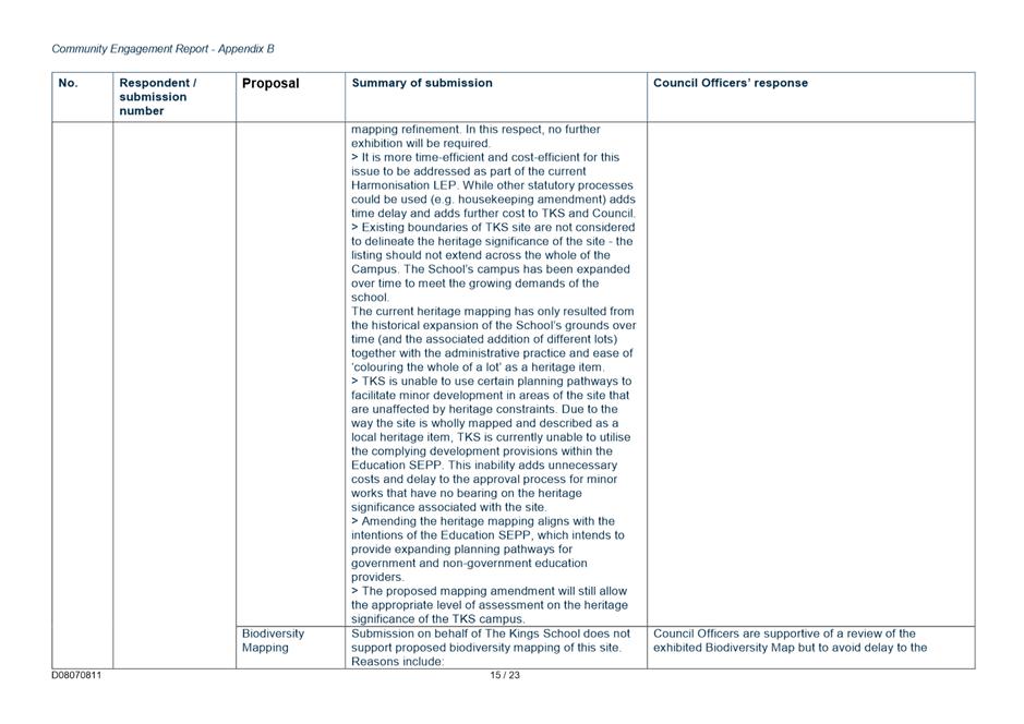
Exhibition of Planning Proposal. A total of 320 submissions were received. A copy of the exhibited Planning Proposal documents are included as Attachments 1 to 8 of this report. |
|
17 August and 20 October 2020 |
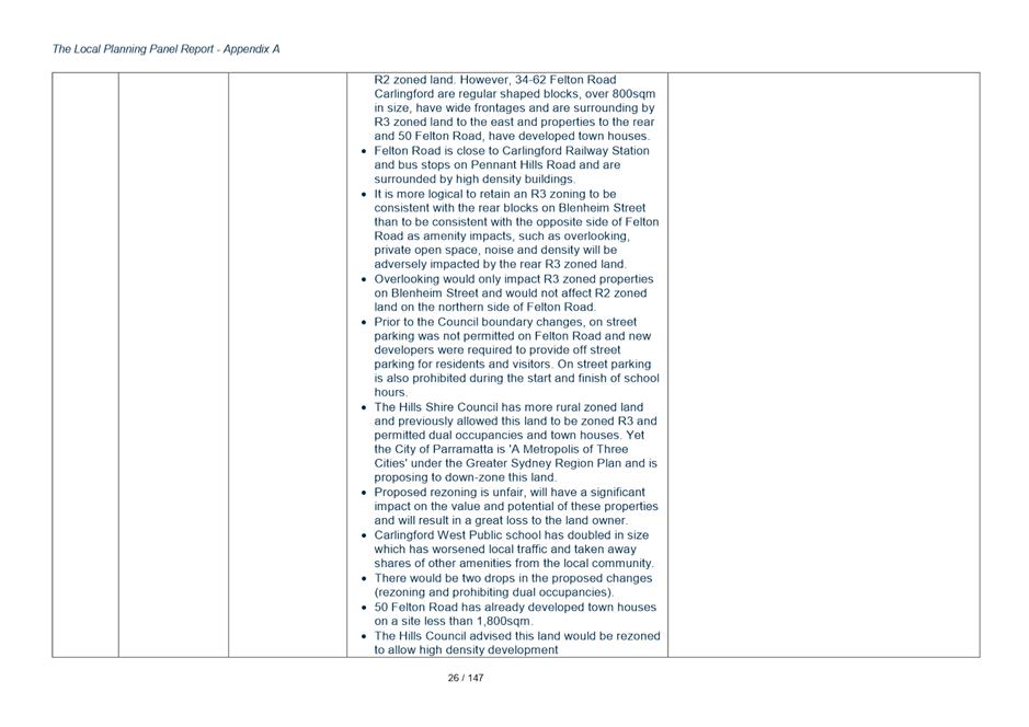
Gateway Determination extended by DPIE until 30 June 2021. |
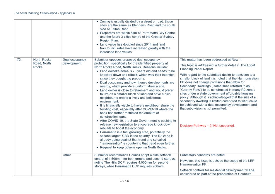
|
17 May 2021 |
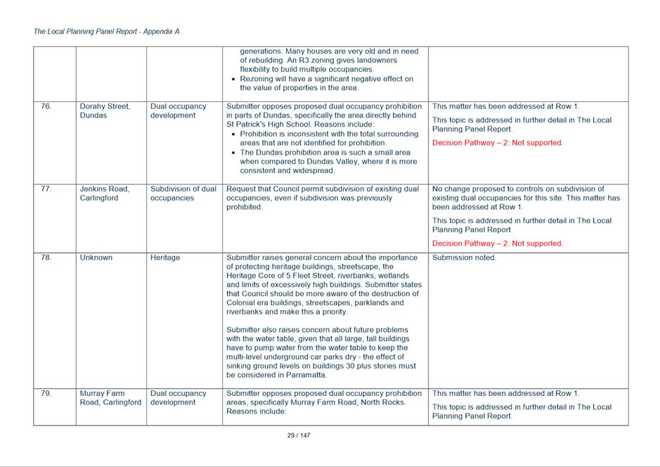
Councillor Workshop - Post Exhibition update. |
|
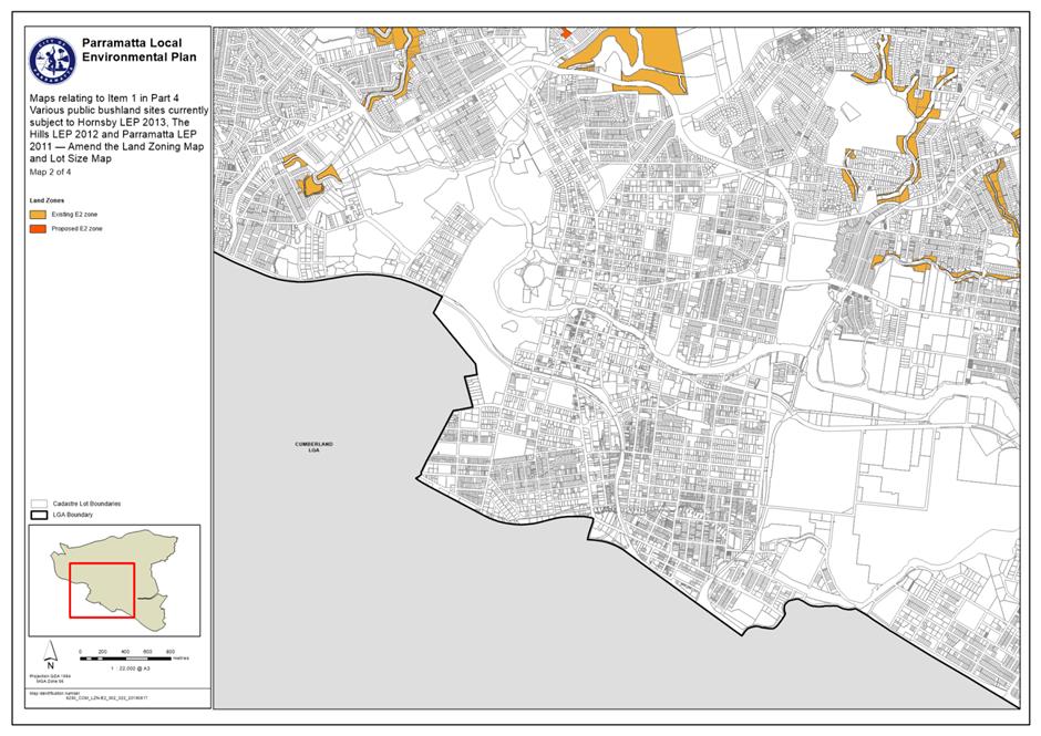
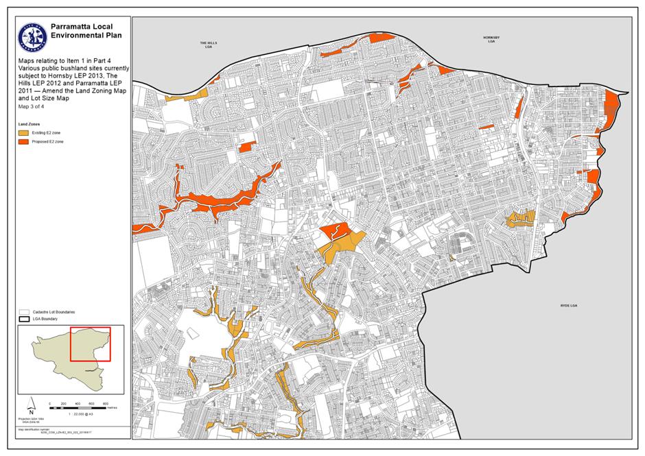
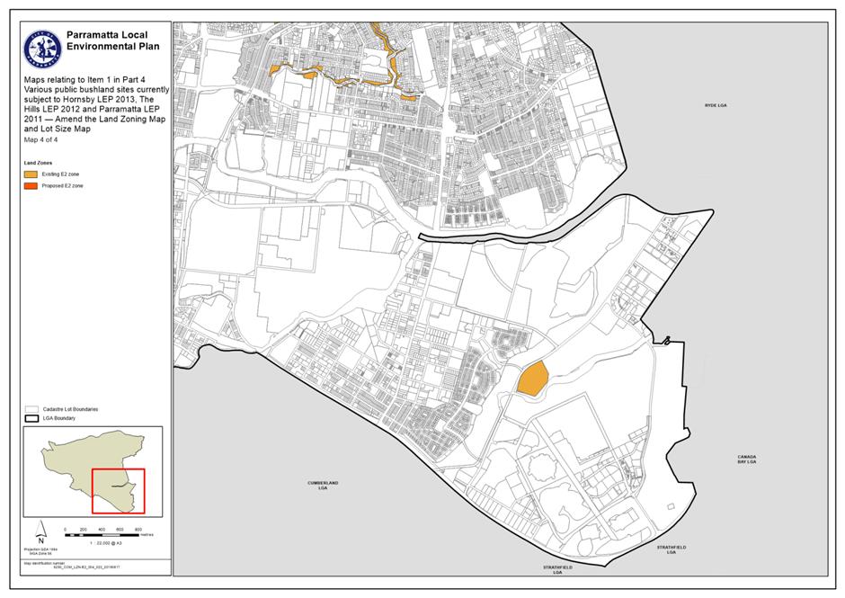
28 May 2021 |
Council requested a Gateway extension from DPIE until 31 July 2021. A response from DPIE is pending. NOTE: The timeframe for submitting the PP to the LPP for finalisation by 30 June 2021 is consistent with ‘Alteration to the Gateway Determination’ issued on 30 June 2021. However, the report to Council for a decision to be made will not occur until 12 July 2021. Hence, an extension to the Gateway Determination date was sought. |
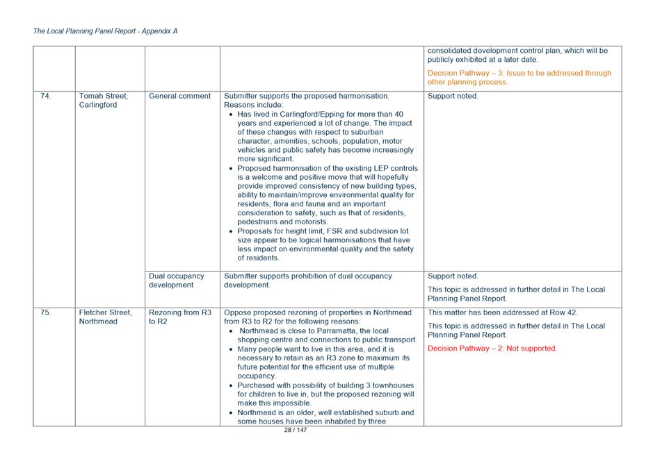
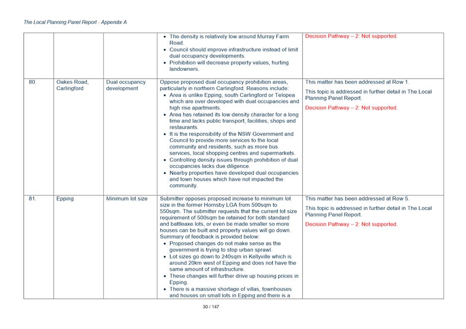
COMMUNITY ENGAGEMENT
7. A communication strategy was developed which outlined how Council would consult with the community during the Harmonisation Project and the PP and draft PLEP exhibition period to ensure a fit for purpose, adequately resourced strategy and to ensure compliance with Council’s Community Engagement Strategy as well as the requirements of the EP&A Act 1979 for planning proposals.
8. The communication strategy for the Harmonisation PP and draft PLEP involved the following communication mechanisms:
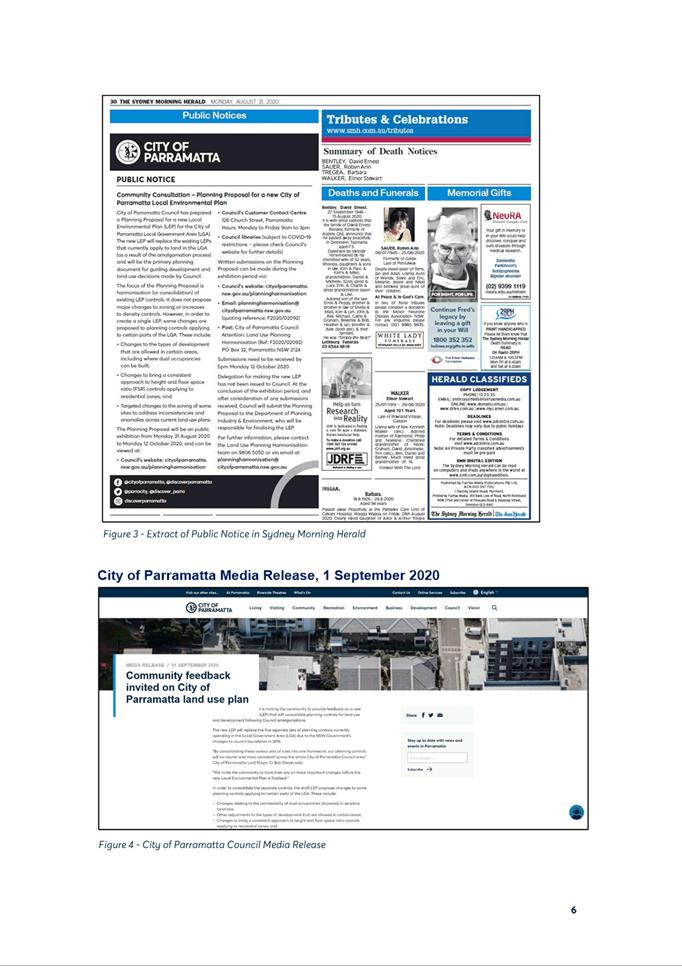
· The Harmonisation PP and draft PLEP were exhibited for six (6) weeks commencing on Monday, 31 August 2020 and concluding on Monday, 12 October 2020
· Notification Letters – posted
· Notification Email
· City of Parramatta Website
· Participate Parramatta engagement portal
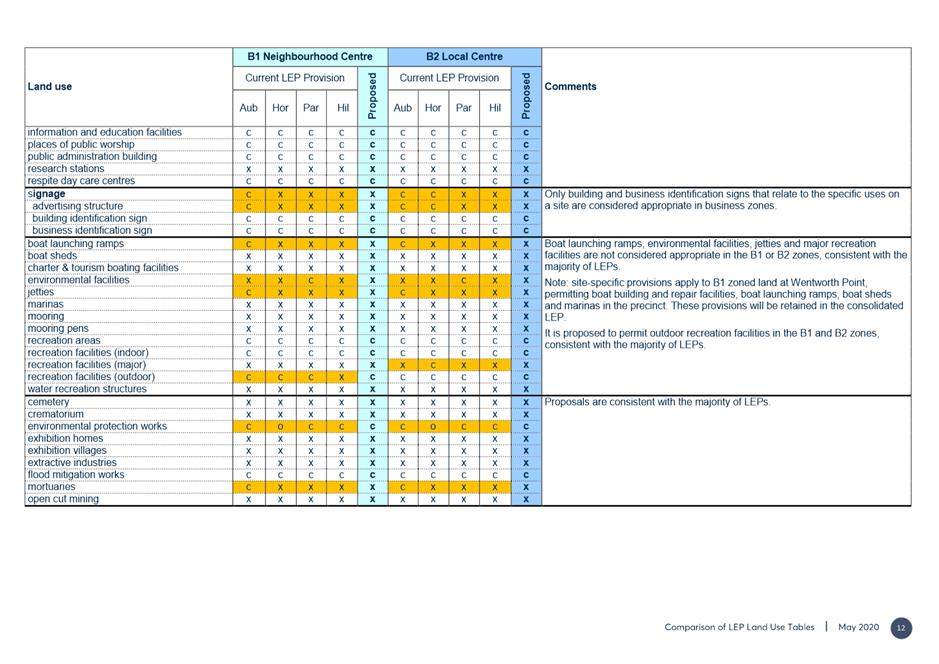
· Newspaper advertisement
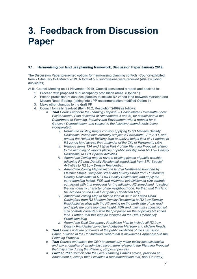
· Media Release
· Social media including Facebook
· Booked phone calls referred to as ‘Phone a Planner’ sessions
· Hard copies of the exhibition package at the Council Contact Centre and Libraries
· Electronic Direct Mail (EDM’s sent)
· Online submission portal and formal submission process
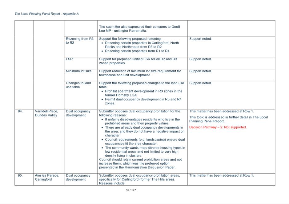
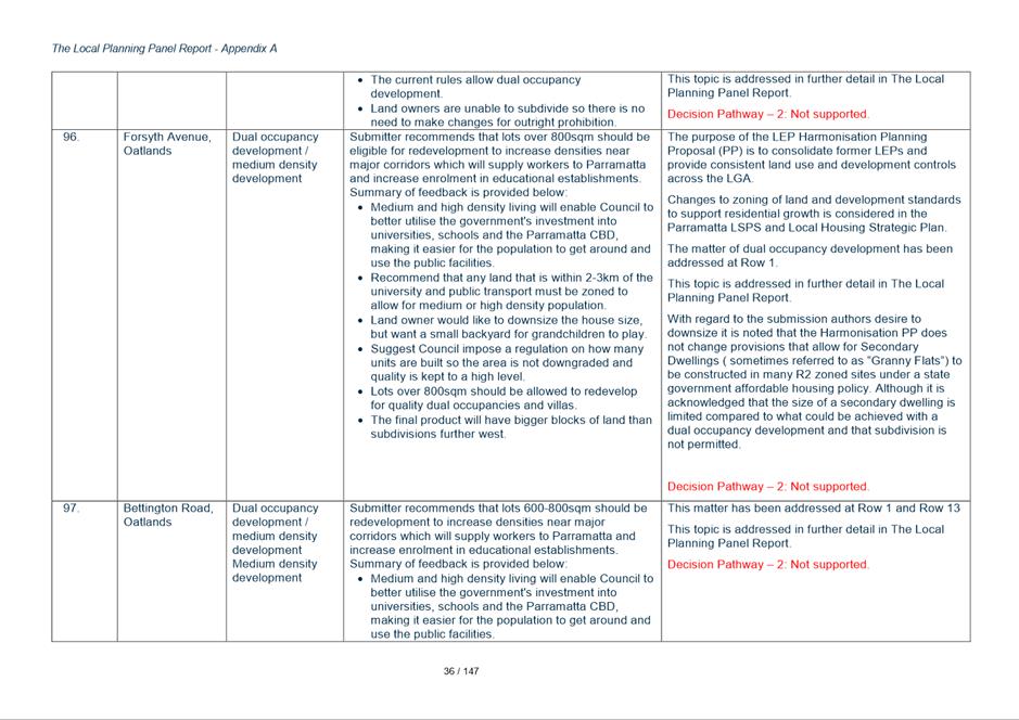
COMMUNITY FEEDBACK
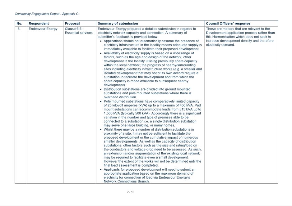
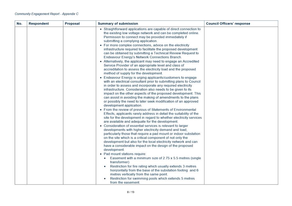
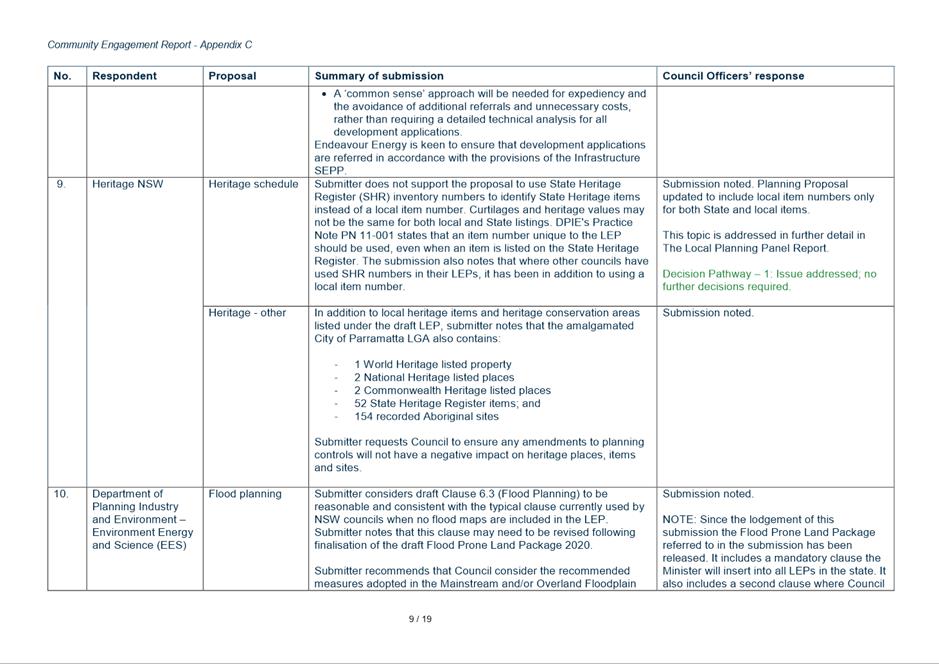
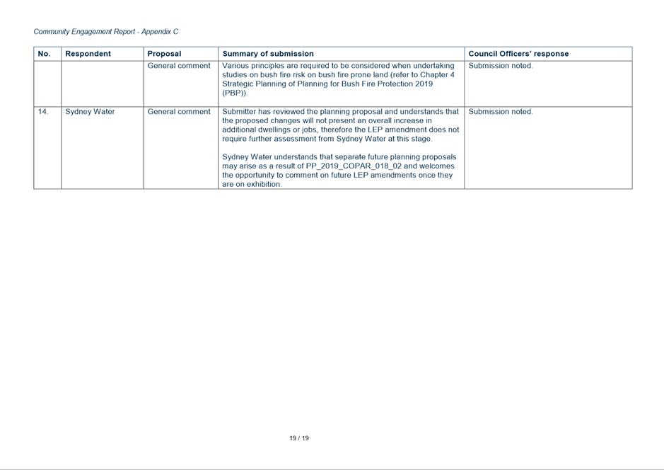
9. The community feedback is detailed in the Community Engagement Report in Attachments 9 to 12.
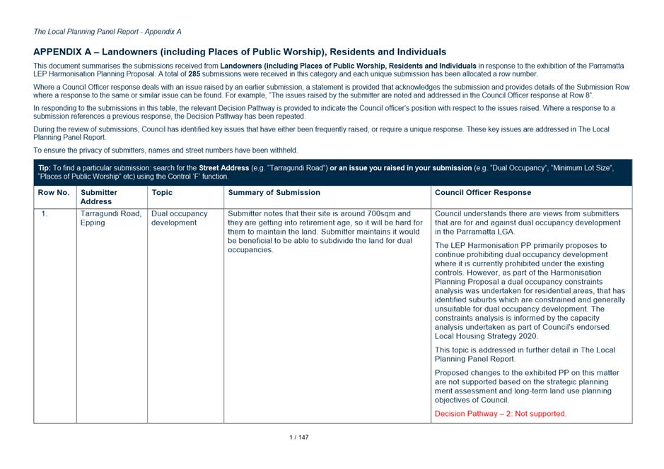
10. A total of 320 submissions were received from the community in response to the public exhibition of the Harmonisation PP. Submissions are categorised as follows:
· Land Owners, Residents and Individuals (285 submissions);
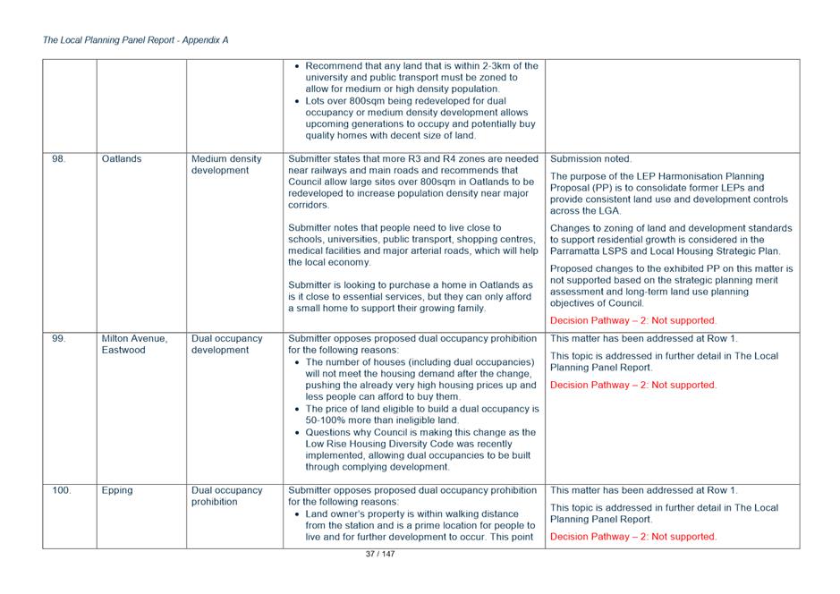
· Public Authorities, Service Providers and Elected Officials (21 submissions); and
· Institutions, Organisations and Consultants (14 submissions).
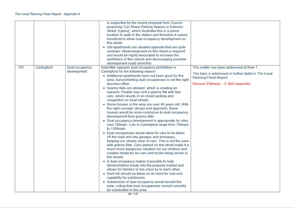
11. The summary of submissions appended to the Community Engagement Report provides provide a summary of each submission and a response to the issues raised within the submission.
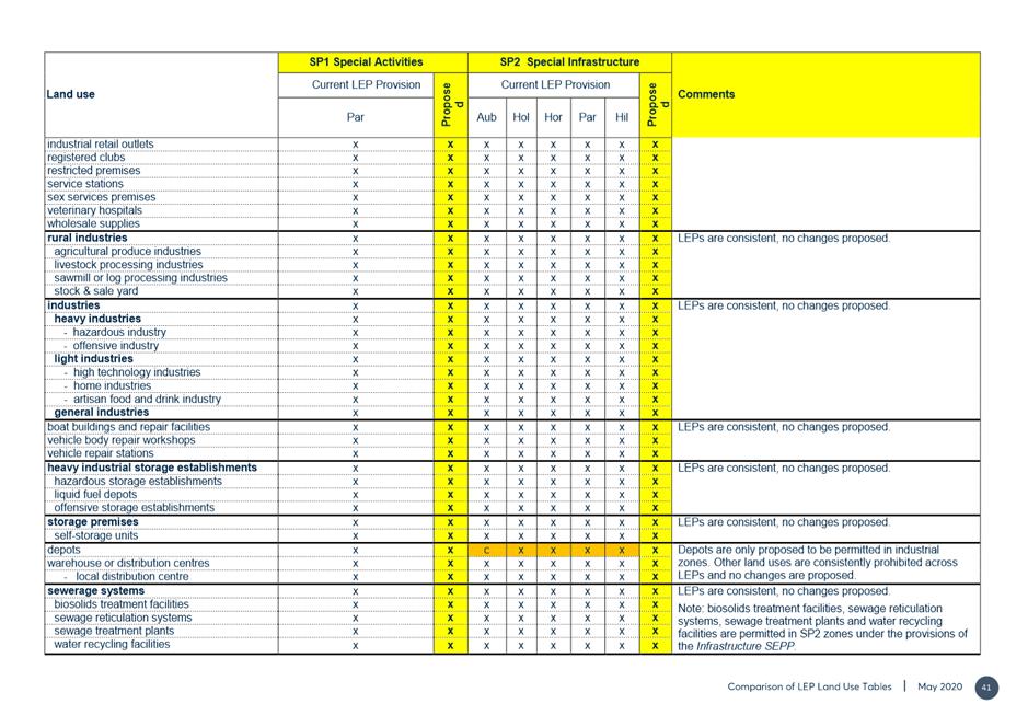
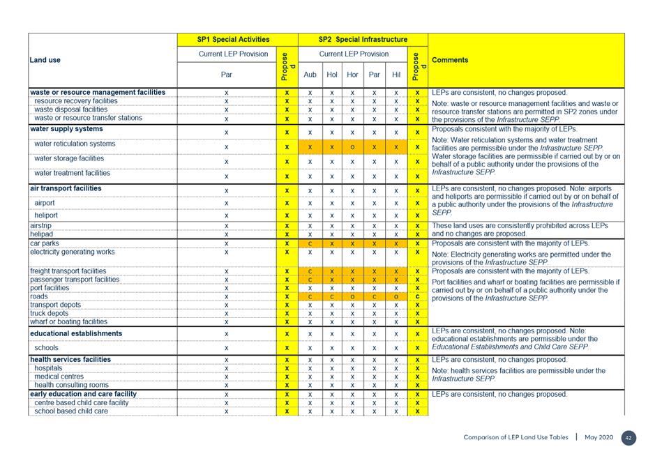
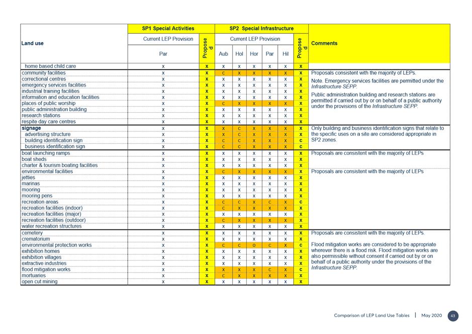
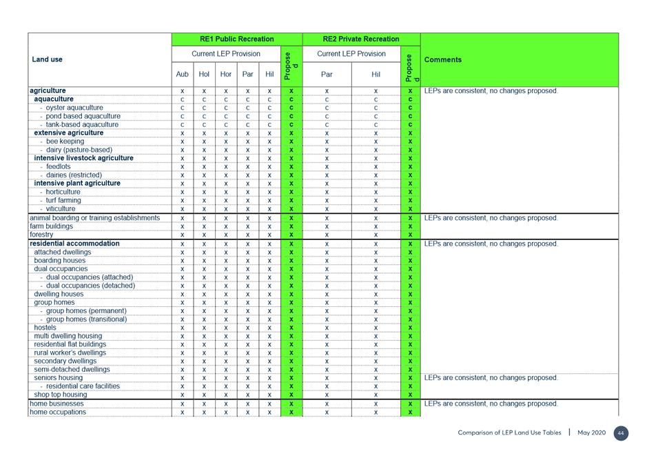
PLANNING DECISION PATHWAYS
12. Some of the submissions sought changes to the exhibited planning controls. Council officers seek to minimise the number of changes made to the exhibited plan to those of minor significance. The risk of adopting significant changes without re-exhibition is that the Plan can be declared legally invalid as occurred in the case of Friends of Turramurra Inc vs Minister for Planning before the Land and Environment Court ([2011] NSW LEC 128]) where a draft LEP was declared invalid by the Court because of substantive changes made to the instrument post-exhibition without a re-exhibition process.
13. Hence, Council officers recommend proceeding with the Draft Harmonisation PP without re-exhibition as only very minor changes are proposed. There are a number of more significant changes that could be considered by Council, but to avoid re-exhibition it is recommended that a separate housekeeping planning proposal be undertaken or a similar alternate planning process be pursued. The decision pathway approach recommended in this report reflects a cautious approach to the inherent risk to an instrument’s validity.
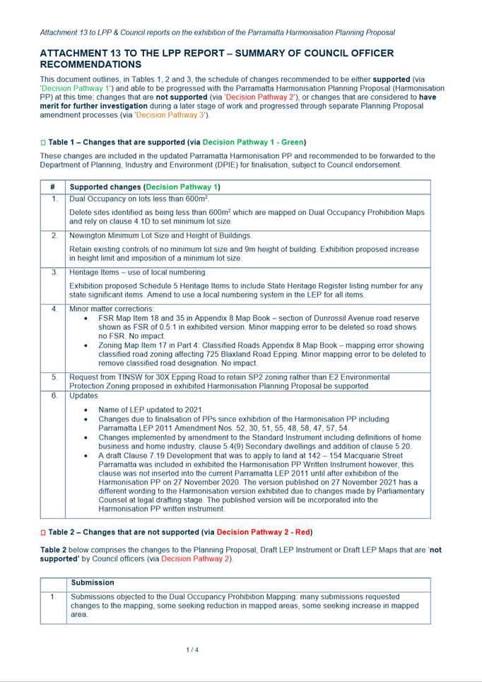
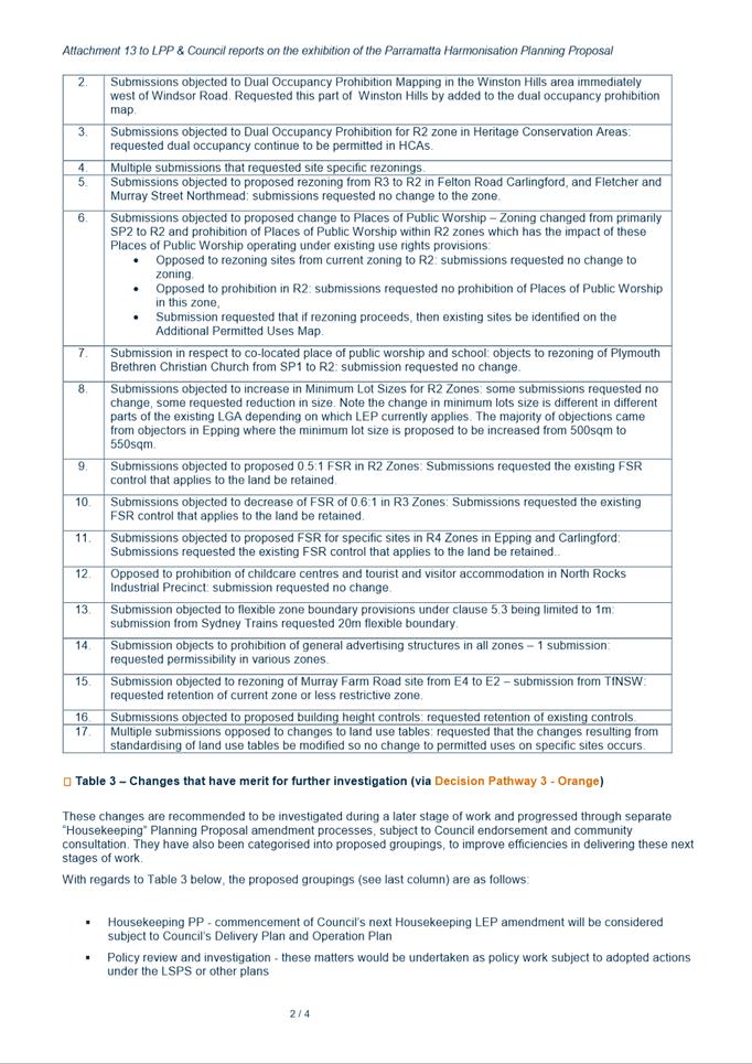
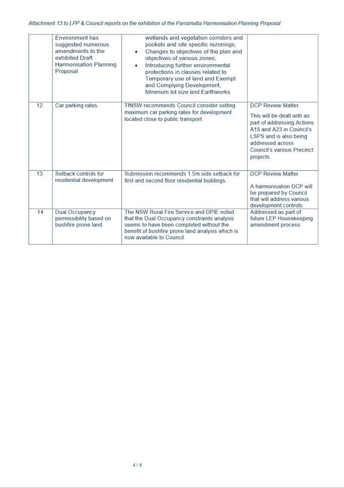
14. Attachment 13 to this report provides a schedule of recommended changes that fall under Decision Pathways 1, 2 or 3, that is,
· Decision Pathway 1 – Minor Amendment Proceed ( Green) – detailed in Attachment 13 Table 1
· Decision Pathway 2 – Proposed amendment does not have merit. Do not proceed (Red) – detailed in Attachment 13 Table 2
· Decision Pathway 3 - Issue to be addressed through other planning process- detailed in Attachment 13 – Table 3.
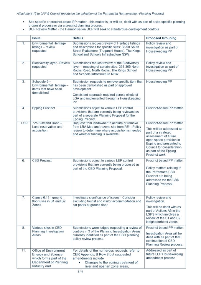
15. Regarding the issues that ‘have merit for further investigation’ listed in Attachment 13 Table 3, an assessment of each of the issues raised will be undertaken once the Harmonisation Planning Proposal is finalized. This allow the issues to be prioritised and a work program to be reported to Council later in 2021 to determine when these further reviews should proceed.
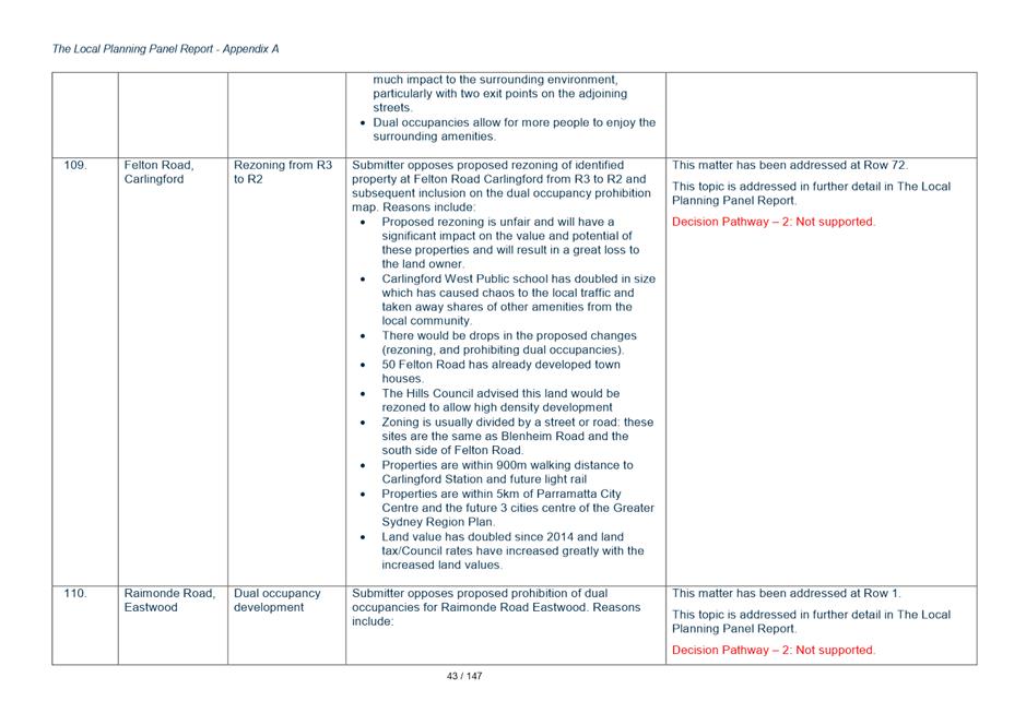
16. If Council wishes to proceed with these amendments immediately, a resolution would need to be pursued to re-exhibit the Harmonisation Planning Proposal with these amendments included. This would delay the consolidation benefits of moving to a single LEP.
Feedback from Landowners, Residents and Individuals
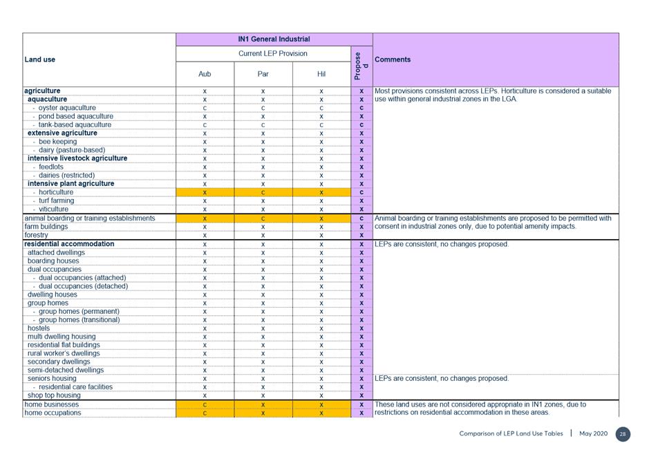
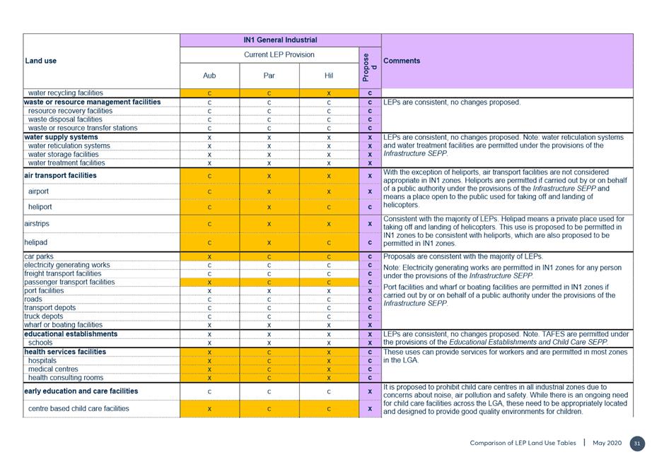
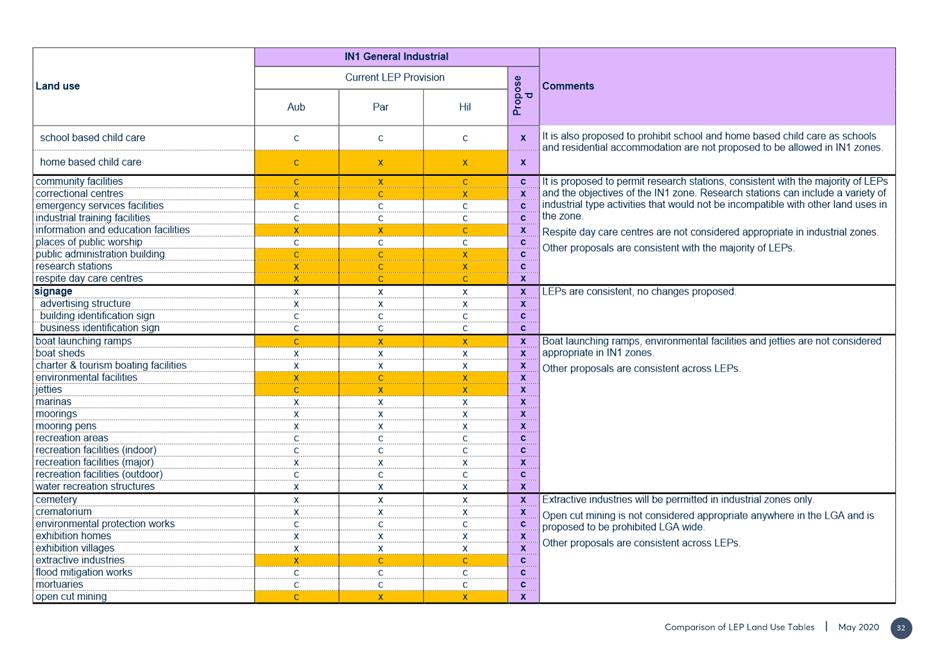
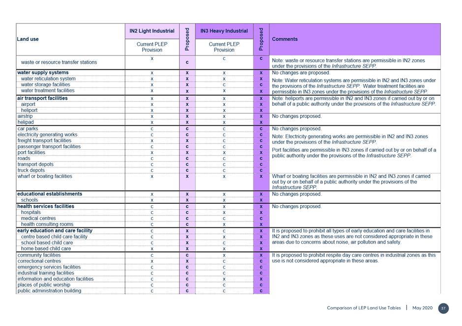
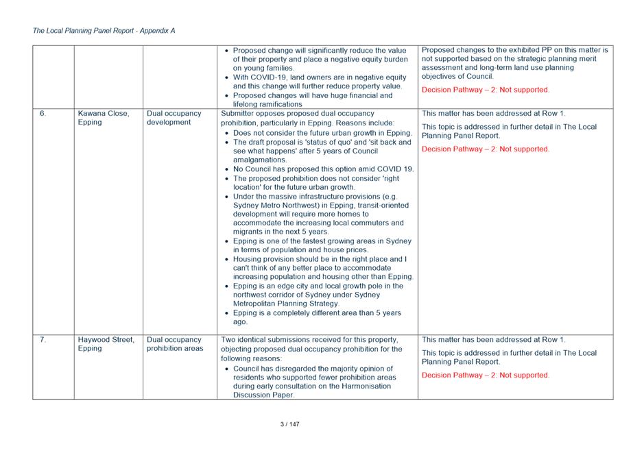
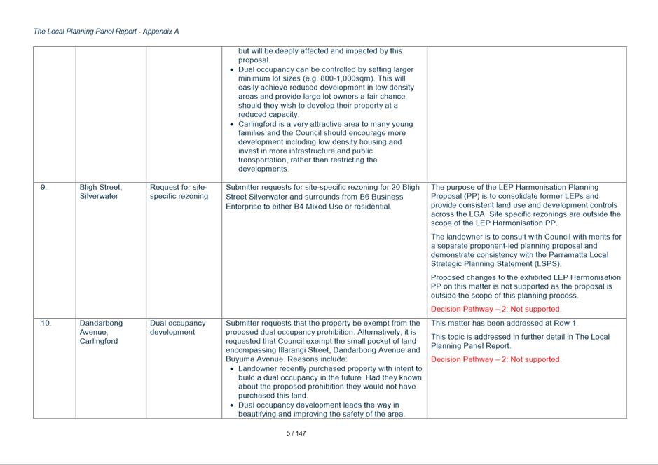
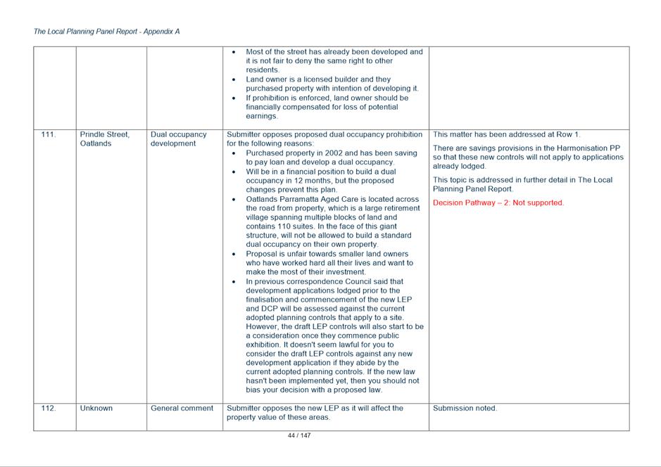
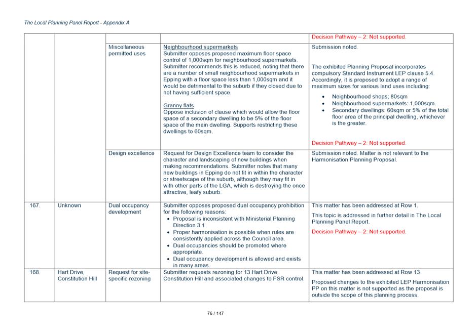
17. Whilst each potential amendment requested in the submissions is addressed in Attachments 9-12 this section of the report will deal with 15 issues which were either raised in numerous submissions or which have more significant policy implications and so should be highlighted for Councillors.
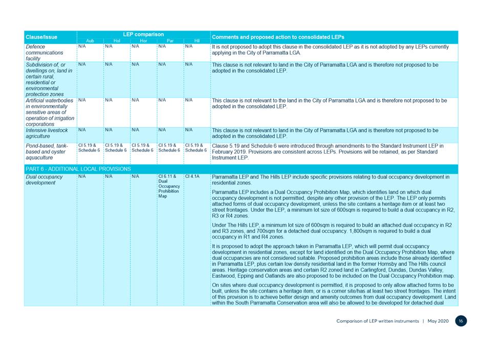
Key Issue 1 - Dual Occupancy
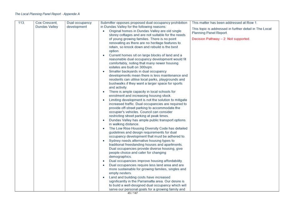
18. The LSPS endorsed in 2020, contains Action A30 (under LSPS Planning Priority 5 p.58) to “finalise the review of dual occupancy and medium density residential zone provisions for Government’s consideration as part of the LEP Harmonisation Project.” The zone provisions have been reviewed as part of the Harmonisation PP and draft PLEP consistent with Council’s LSPS action. Separately, in 2020, Council prepared a Local Housing Strategy, and the recommendations in this report are consistent with that Strategy.
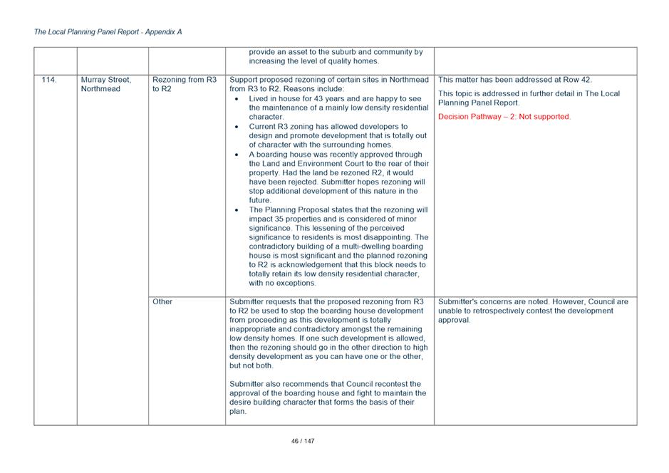
19. The majority of resident submissions received (219 or 77%) received raised dual occupancy as a key issue with submissions either supporting or objecting to the permissibility of dual occupancy in their area. An overview of the key issues raised in relation to dual occupancy is presented below.
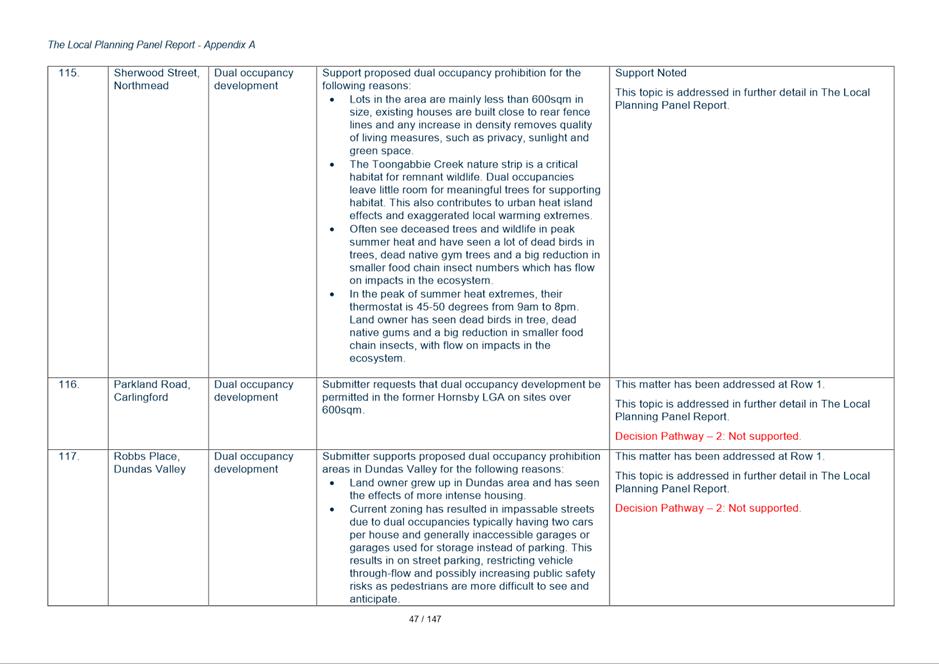
20. The recommendations in this report relating to dual occupancy overall seek to proceed with the recommendations as exhibited with no change to the draft PLEP. The only changes proposed under (Key Issue 1d) relate to minor mapping and administration matters.
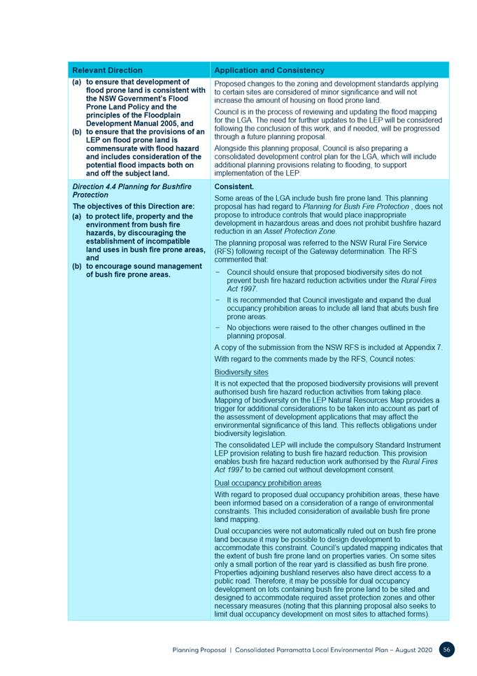
Key Issue 1a - Dual Occupancy – Relaxation of Dual Occupancy Prohibition Areas and Controls
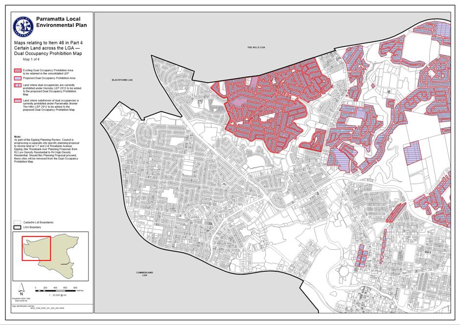
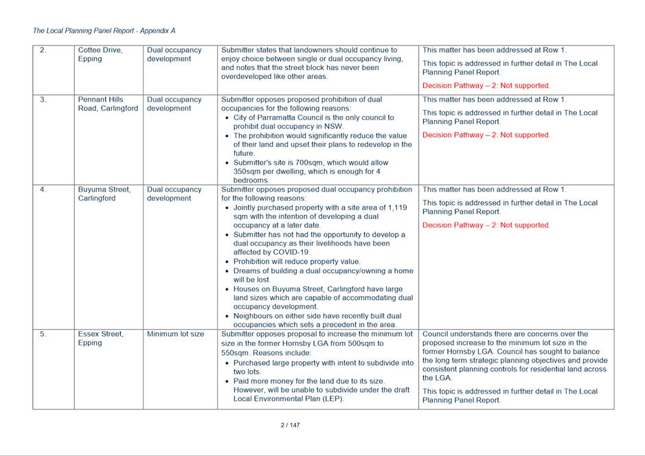
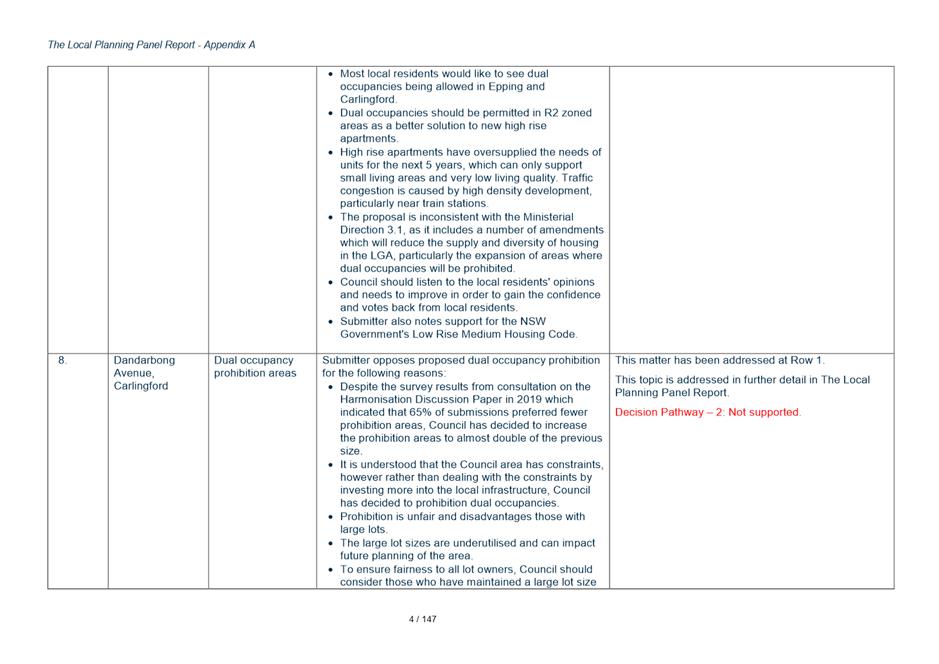
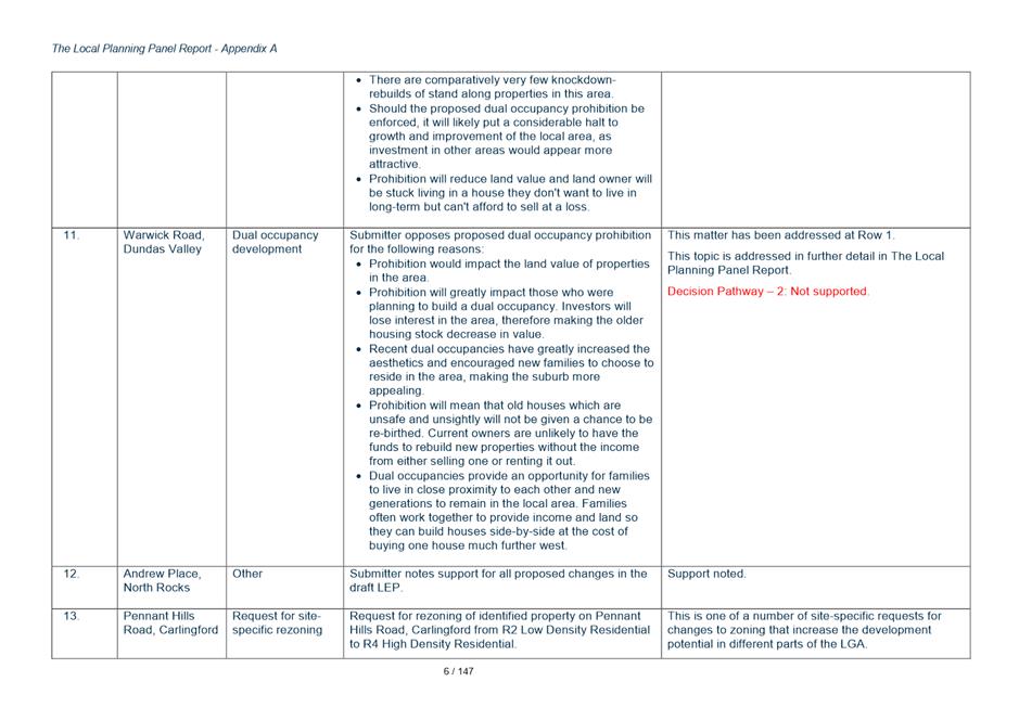
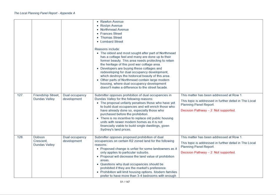
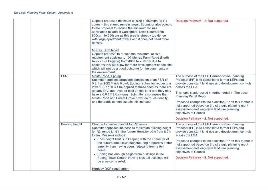
21. A total of 186 submissions lodged sought amendments to the plan to allow dual occupancy development in locations where the Harmonisation PP is seeking to prohibit dual occupancy, or to ask Council to relax its requirement in areas where dual occupancy will be permitted to allow dual occupancy on sites less than 600sqm. The number of submissions who supported the proposed restrictions on dual occupancy development or sought changes to further limit where dual occupancy was permitted was 31 of total submissions).
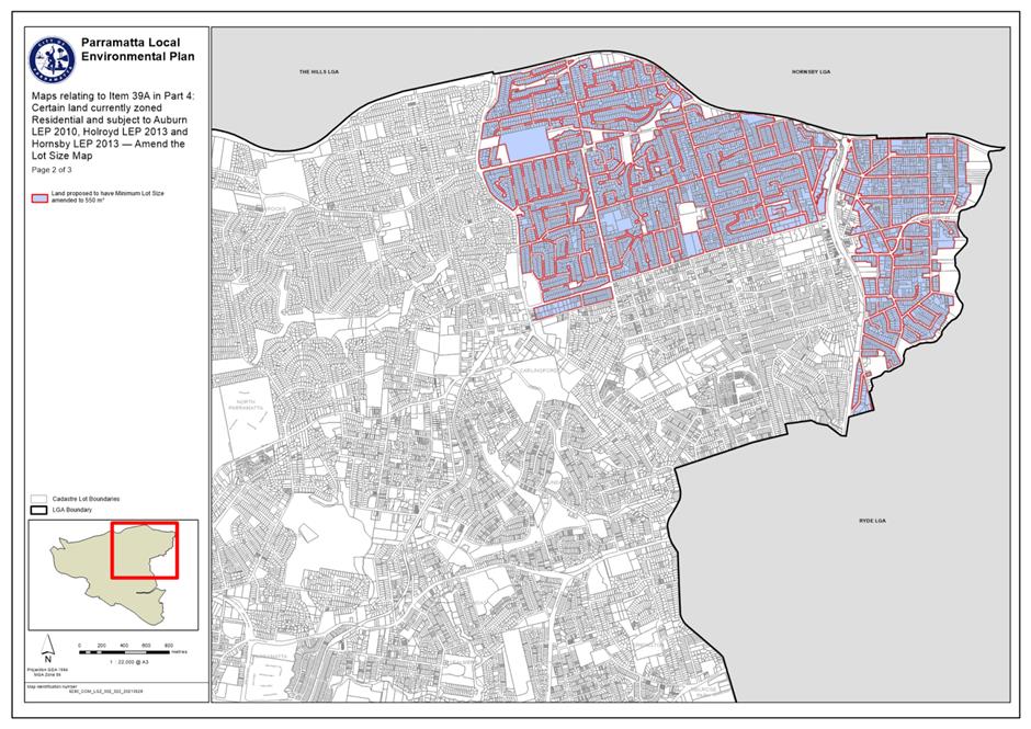
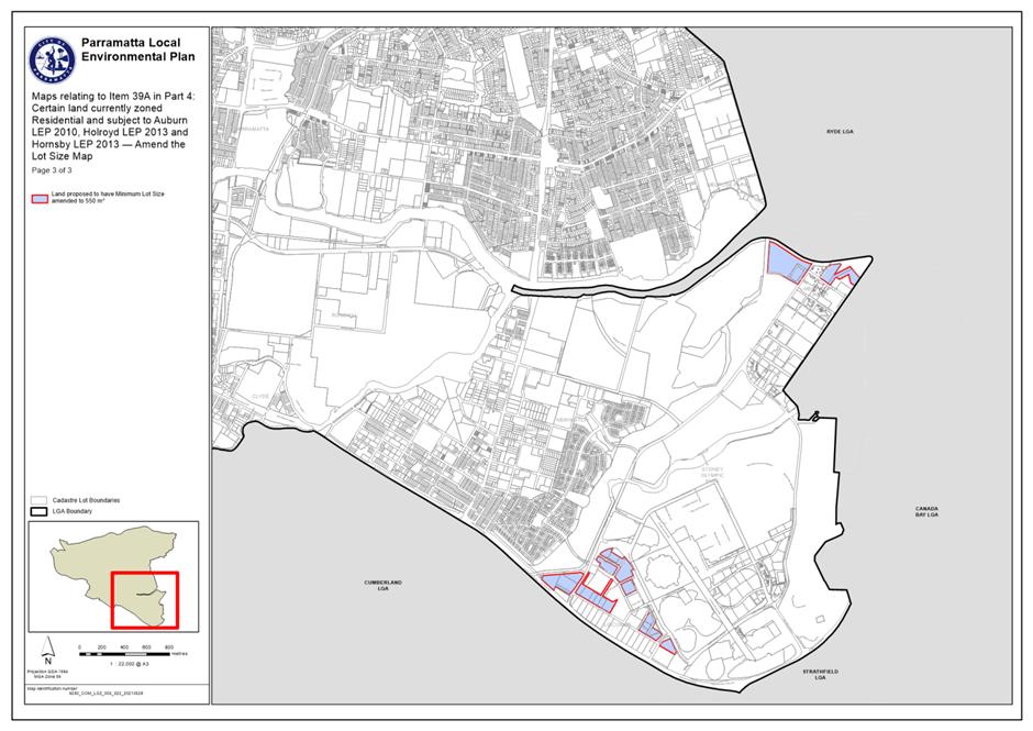
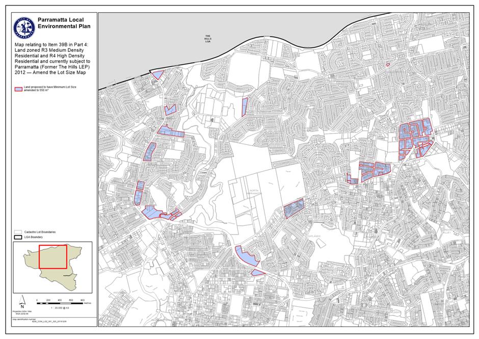
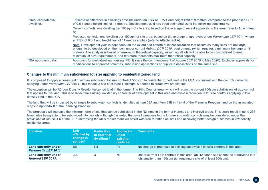
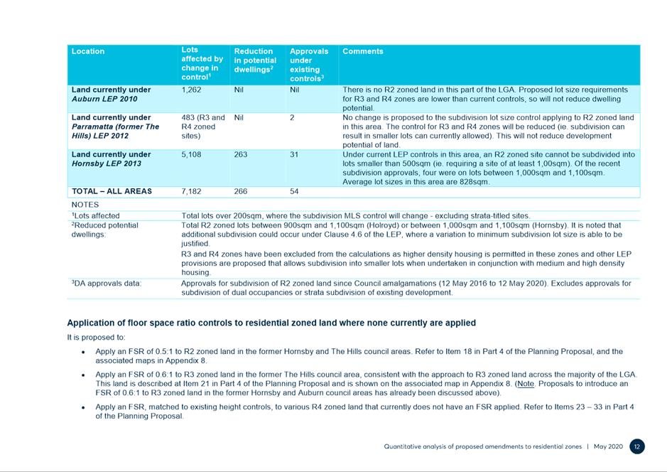
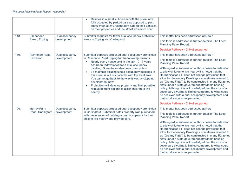
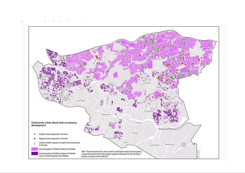
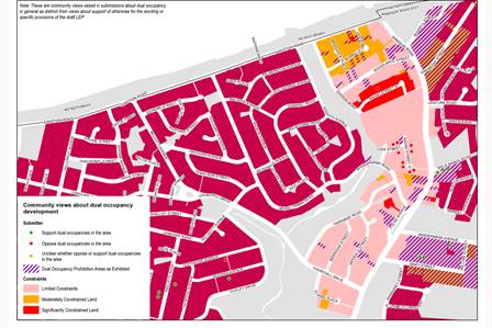
22. There was support for relaxing the permissibility in most of the suburbs where it is proposed to prohibit dual occupancy with particular concentrations in Eastwood, Dundas Valley and Carlingford. Attachment 14 shows the distribution of submissions across the LGA that support or oppose dual occupancy prohibition.
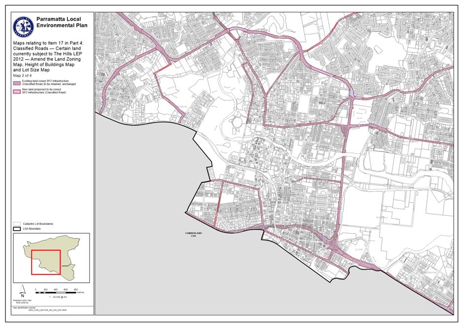
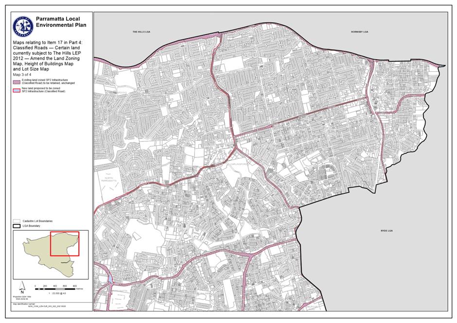
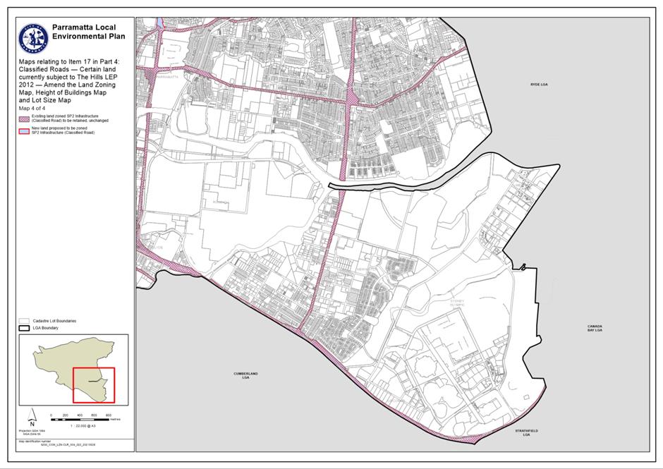
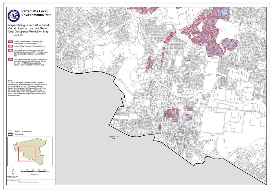
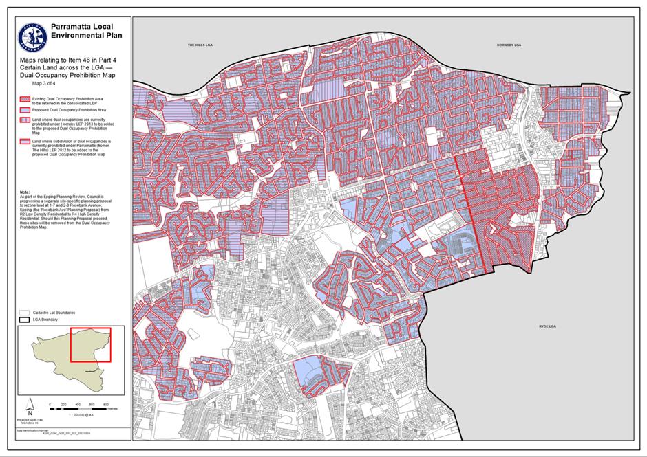
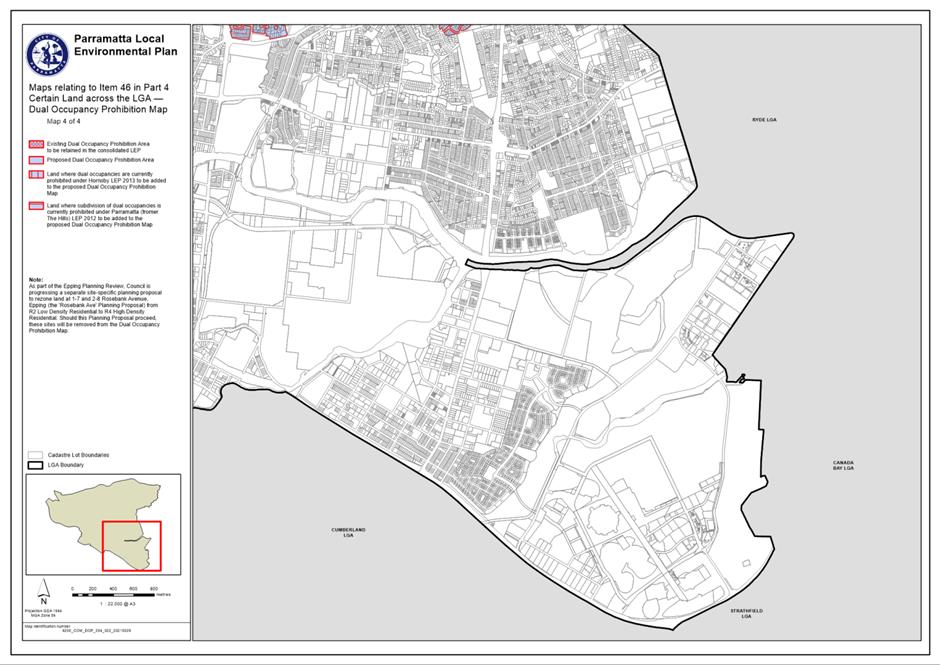
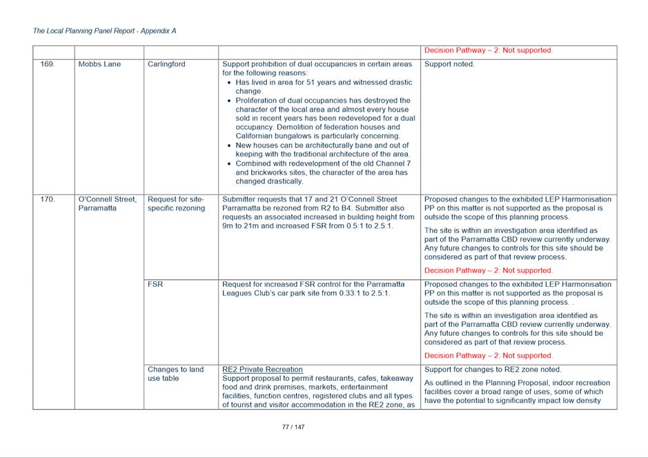
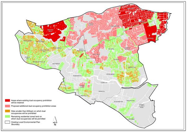
23. Figure 2 below was provided with the exhibited PP and shows the 5 existing LEP controls as they currently apply as well as the proposed controls in the Harmonisation PP. The black line shows the former LGA boundaries.
Figure 2 - Dual Occupancy - Proposed Permissibility and Prohibition areas
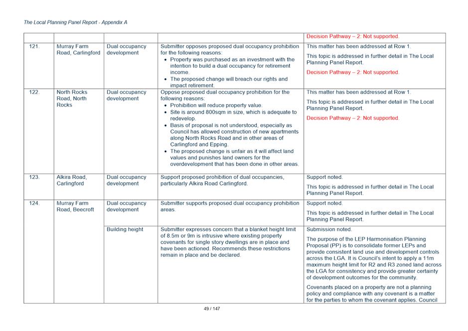
24. The submissions opposing the proposed prohibition of dual occupancies in certain areas raised the following concerns:
· Prohibition areas are unfair, discriminatory and inconsistently applied.
· Dual occupancies contribute to housing affordability, choice and diversity.
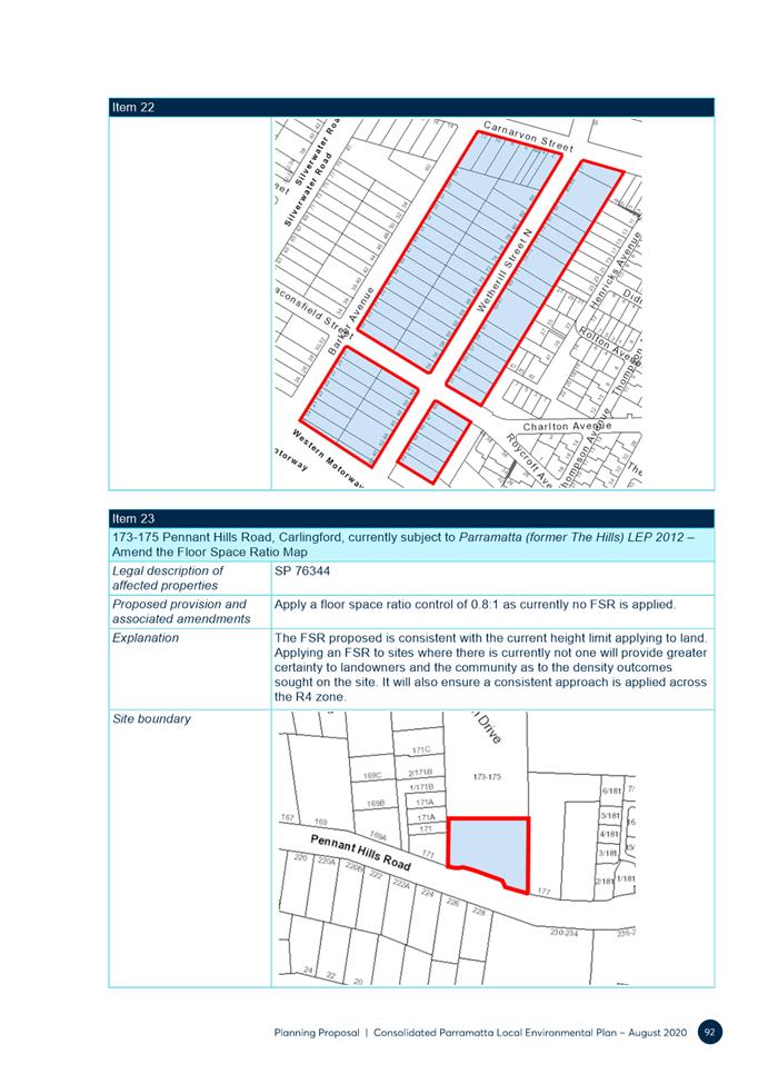
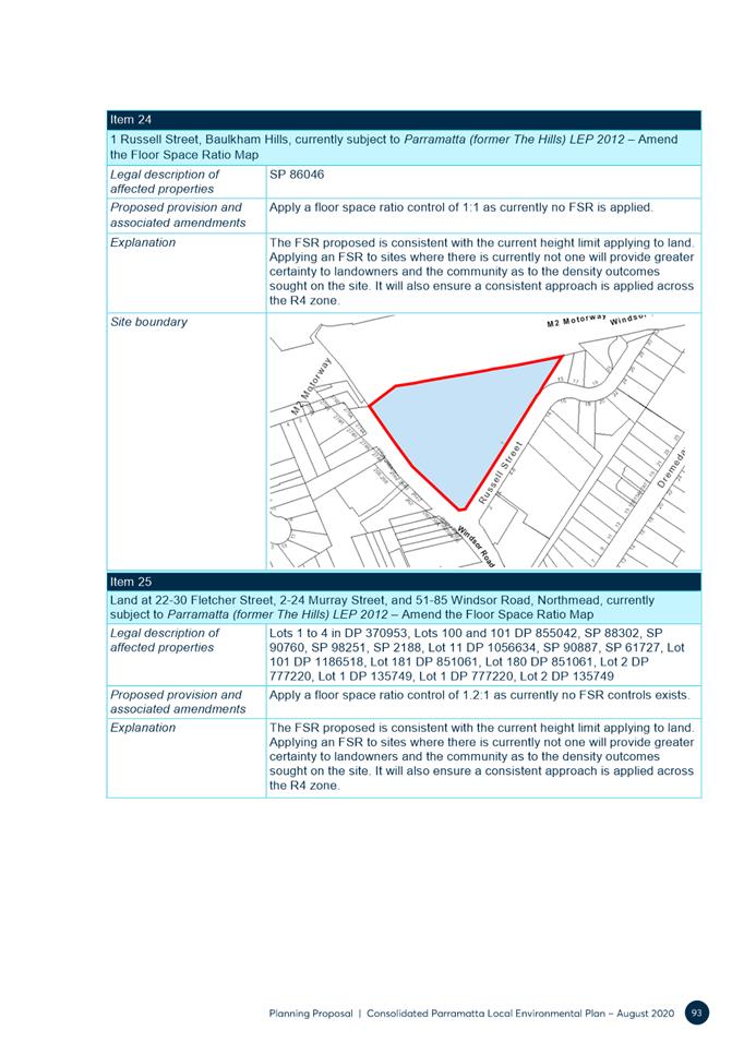
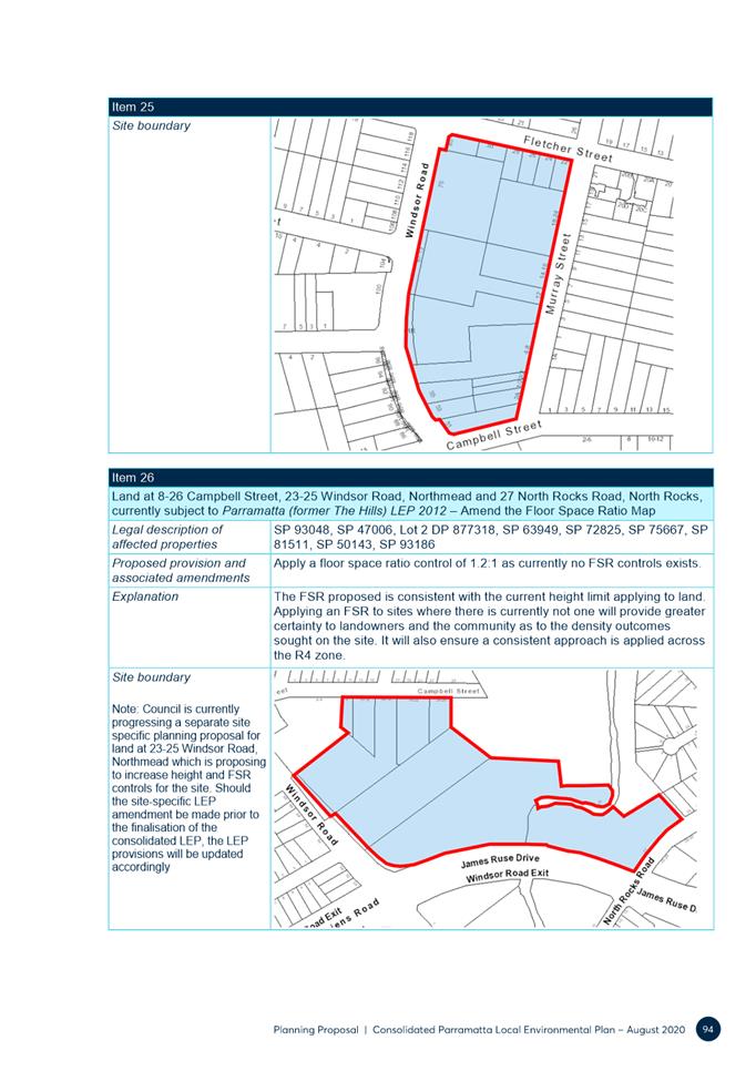
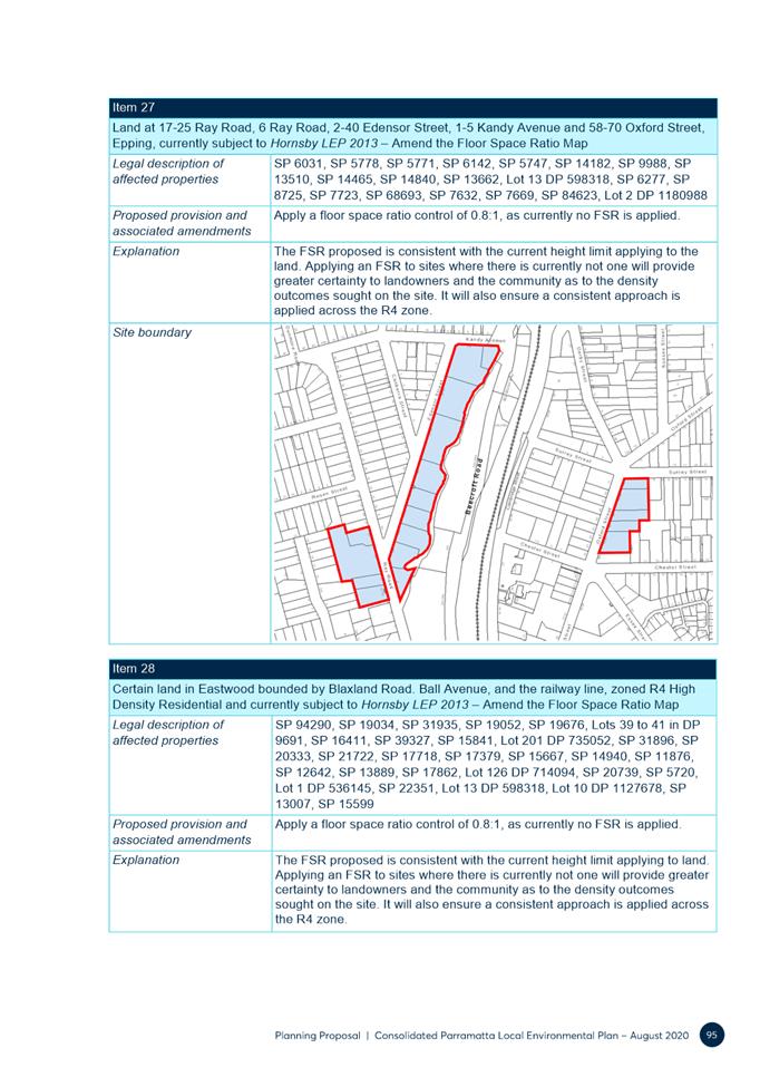
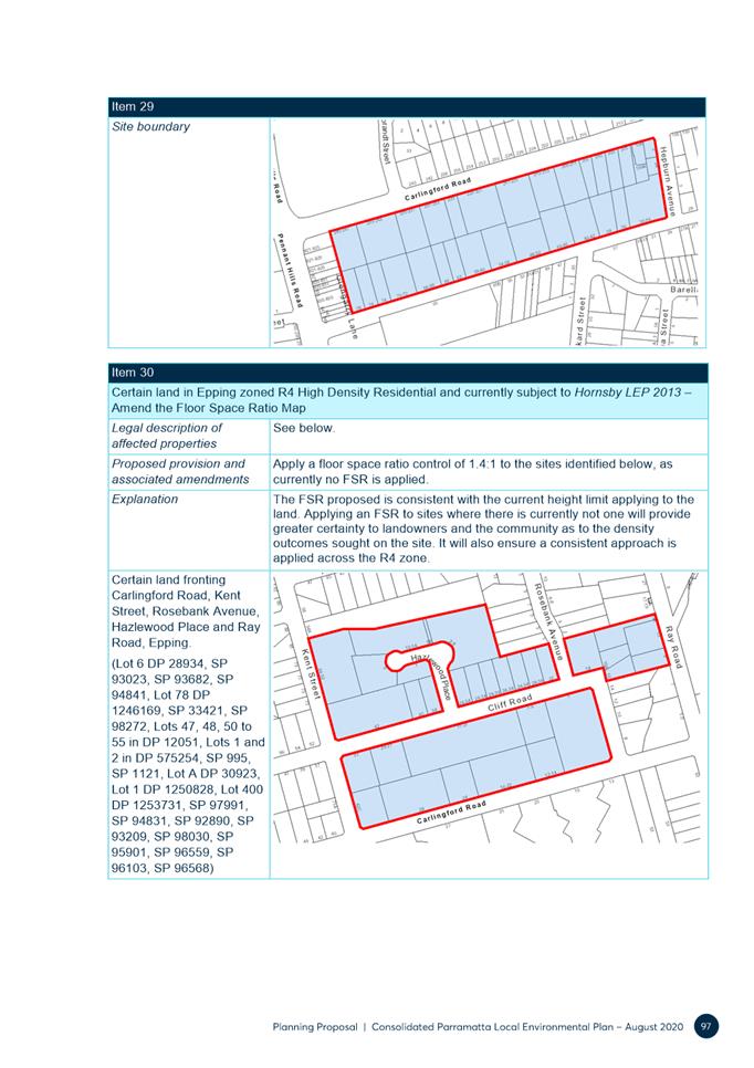
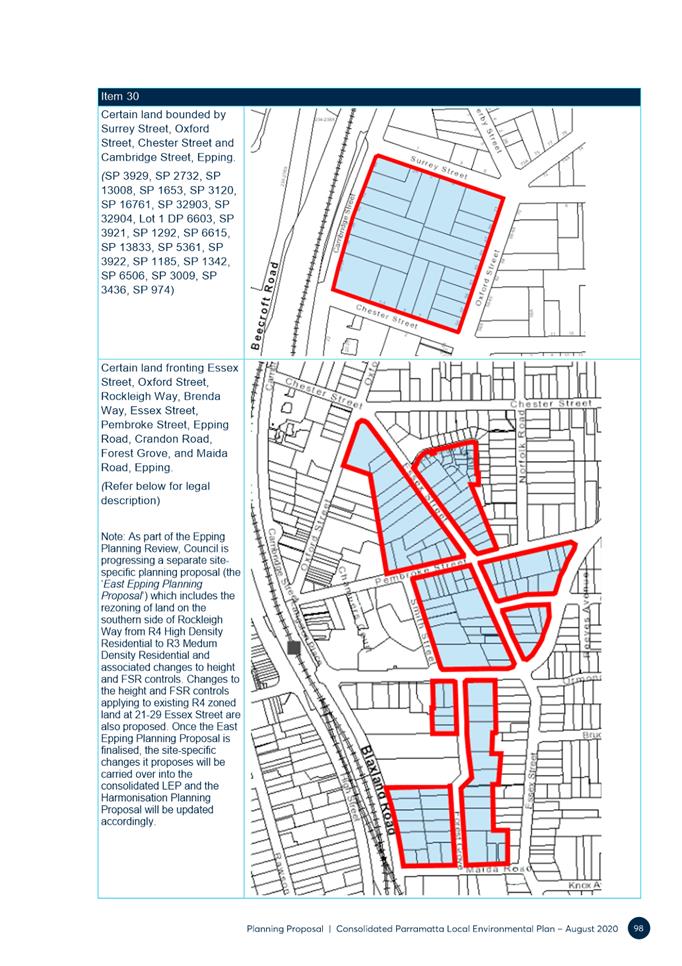
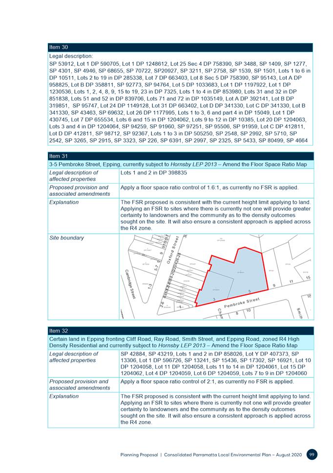
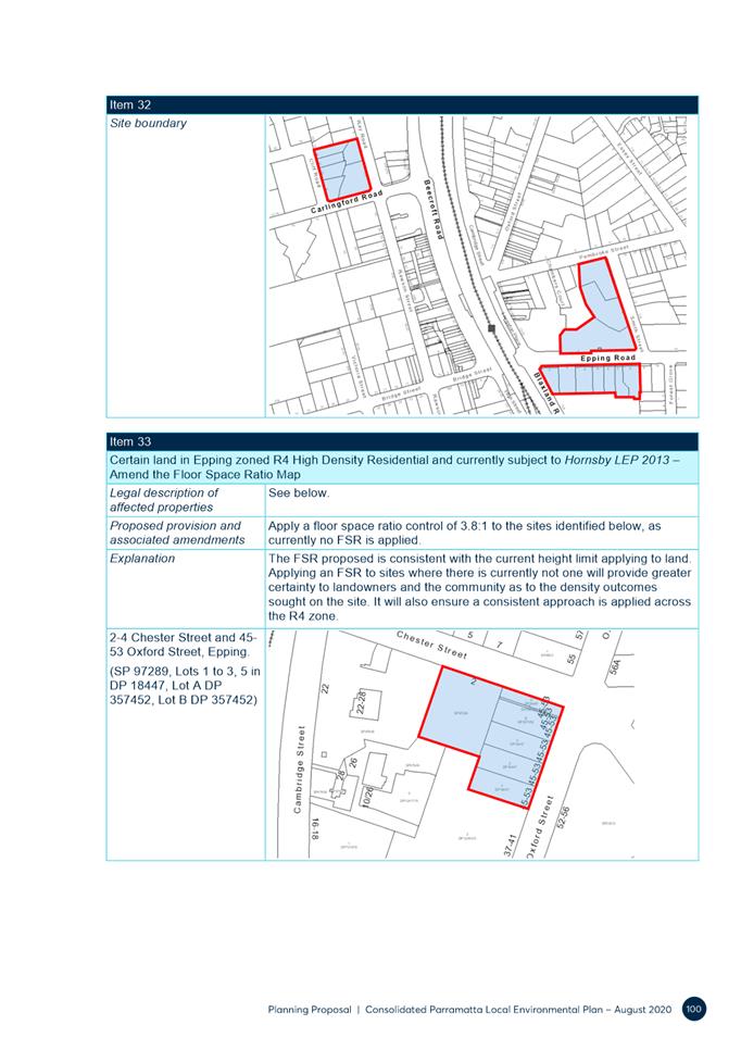
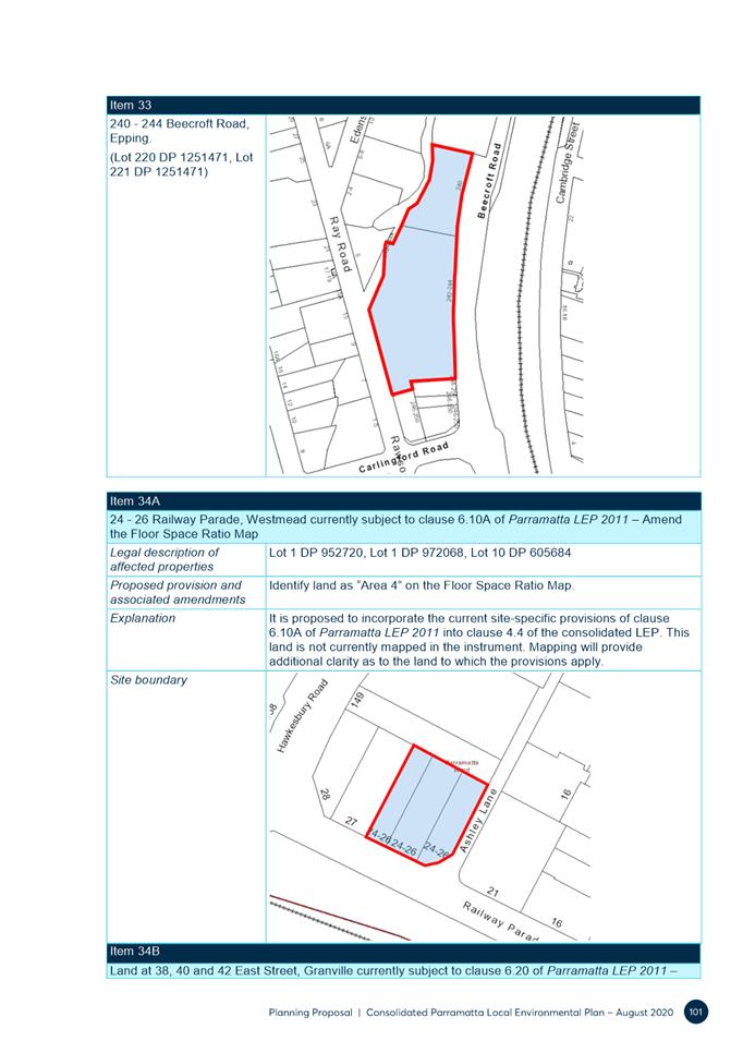
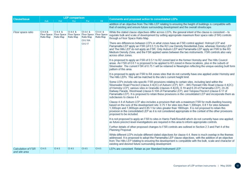
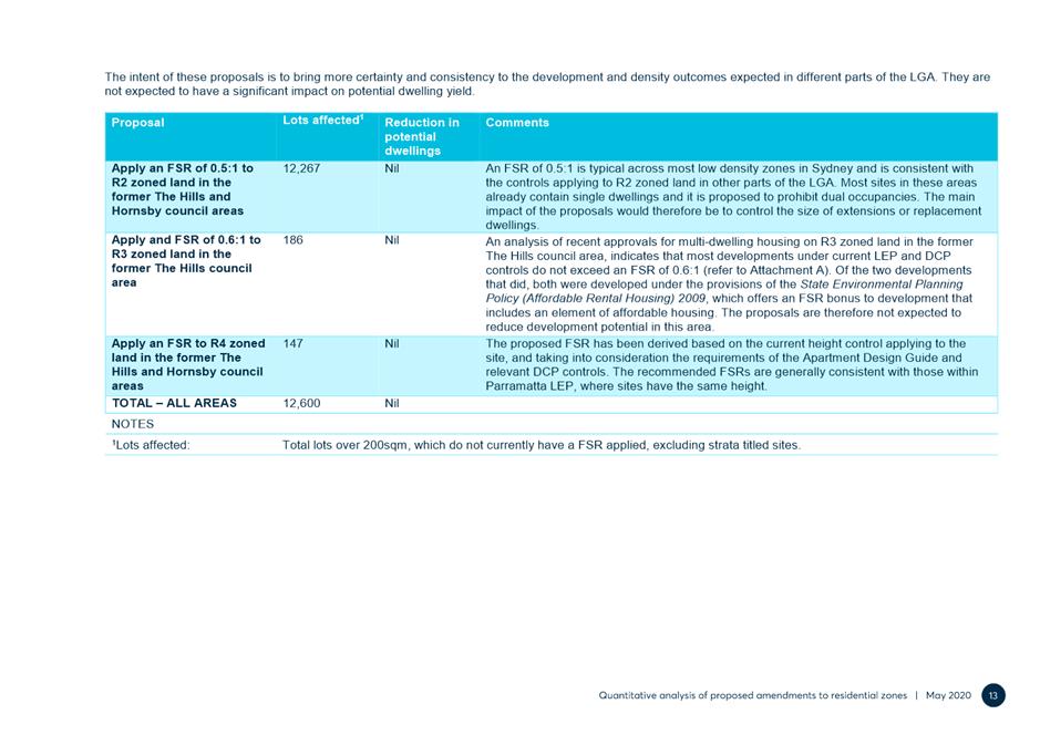
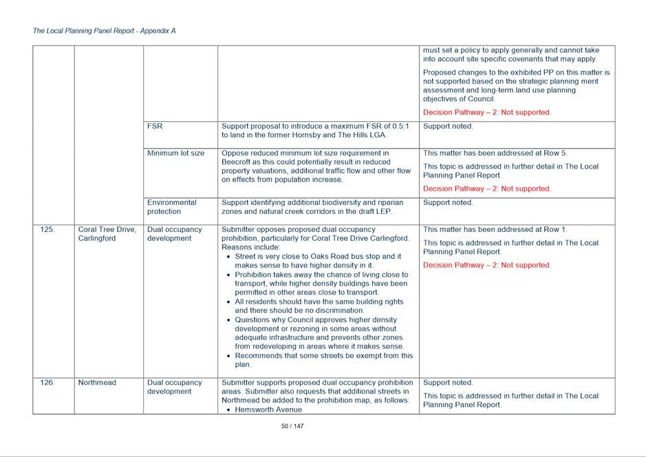
· Prohibition will reduce property value / will have financial implications for land owners.
· The proposal is inconsistent with Ministerial Direction 3.1 as it includes a number of amendments which will reduce the supply and diversity of housing in the LGA.
· Some location are unconstrained according to the Dual Occupancy Constraints Analysis.
· Dual occupancies are already part of many low-density streetscapes and in some cases R2 zoned land includes higher density development.
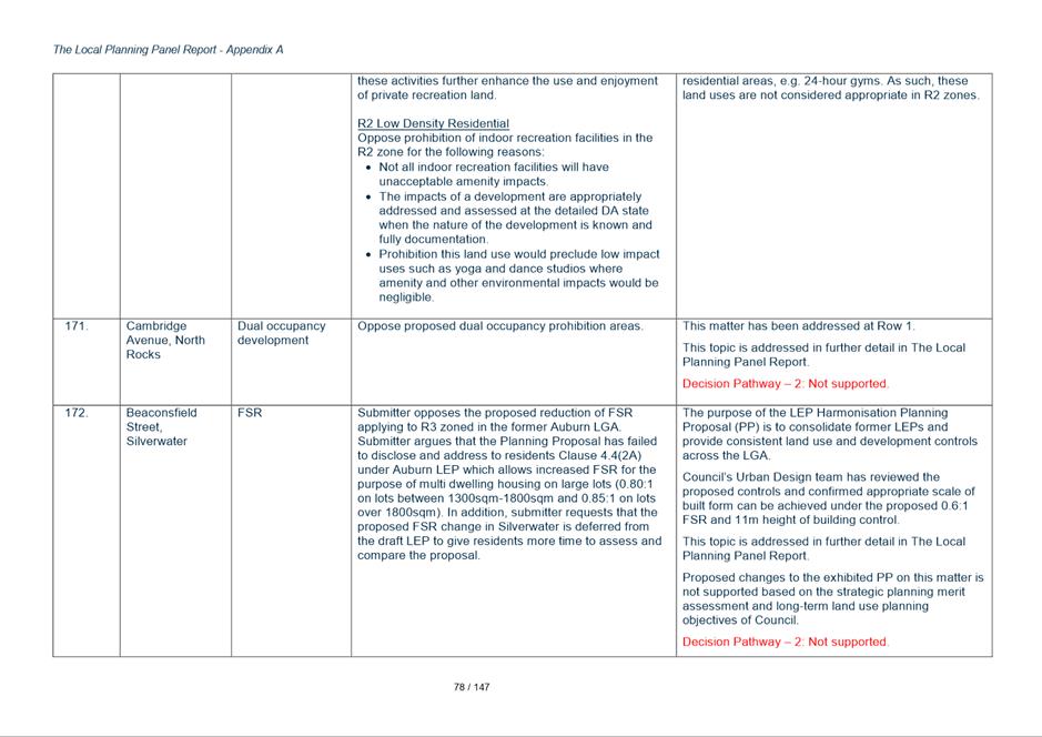
· Dual occupancies can contribute positively to the streetscape and present like a single dwelling.
· This type of development supports and maintains family networks.
· Concerns about negative impact of dual occupancies are unsubstantiated.
· Dual occupancies should be managed through design controls and not outright prohibition, including a larger minimum lot size and frontage requirement.
· Dual occupancy developments offers a better living environment than high rise development.
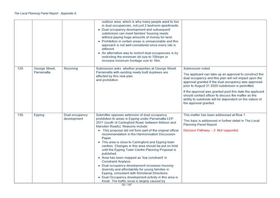
· Some locations are within close proximity to major roads, services and infrastructure.
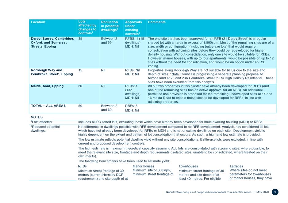
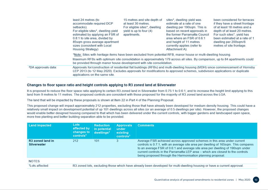
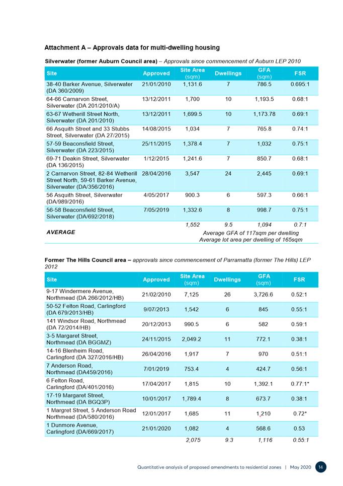
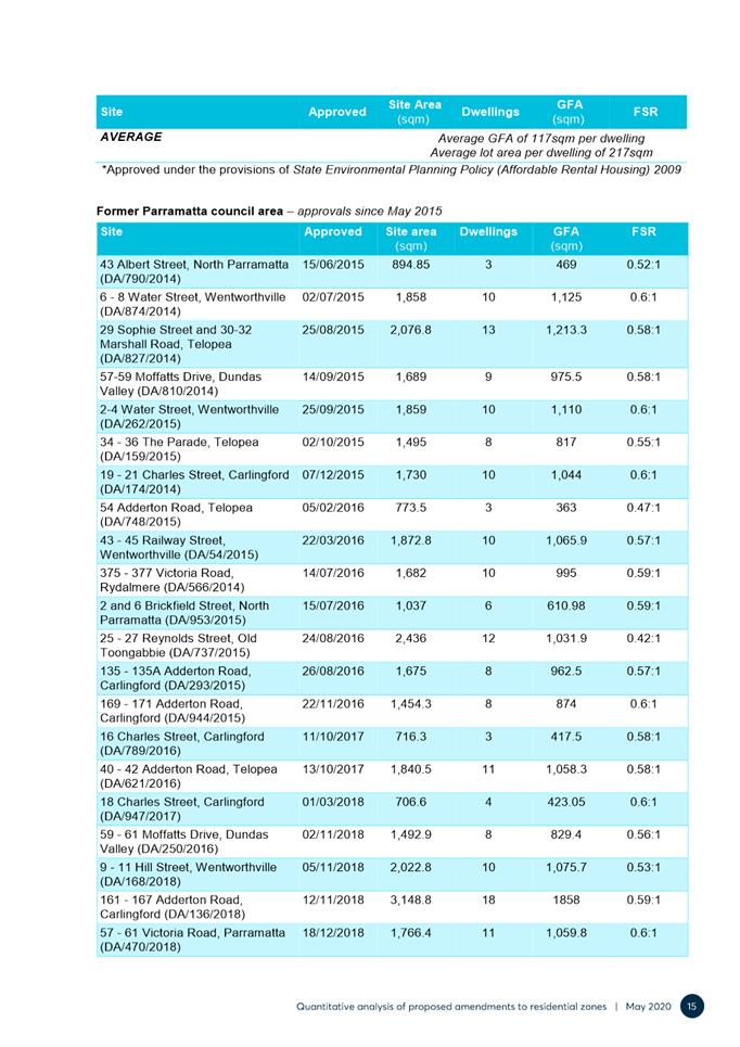
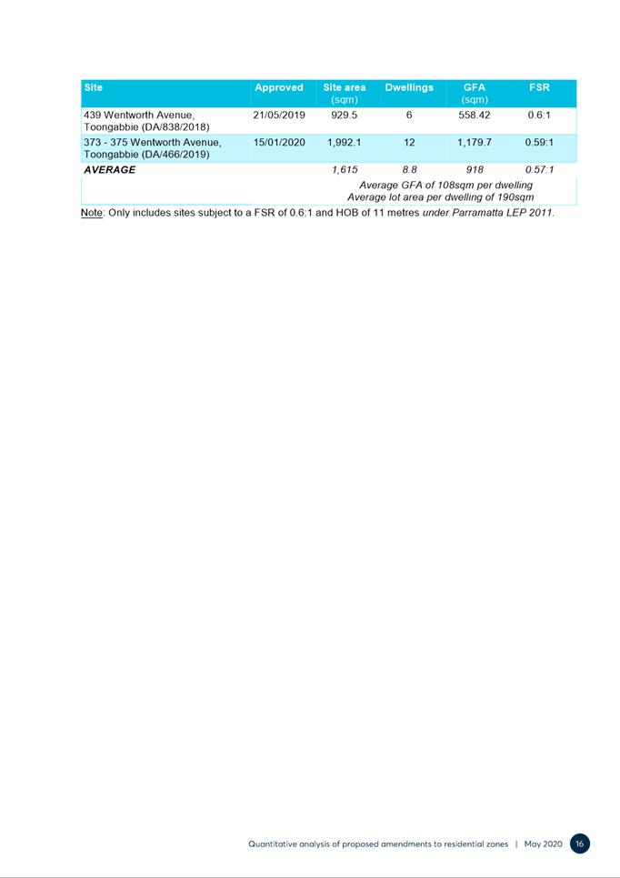
· Traffic and amenity impacts are negligible compared to other types of development.
· Granny flats are allowed and have the same/worse impact.
· Well-designed dual occupancies can be accommodated on lots under 600sqm / the NSW Government permits dual occupancy on lots under 600sqm.
25. The submissions supporting the proposed prohibition of dual occupancies in certain areas gave the following reasons:
· Dual occupancies are incompatible with the character of low density areas and are more conducive to R3 or R4 zoning.
· Dual occupancy development results in more on street parking and creates traffic and congestion issues.
· Concerns about safety.
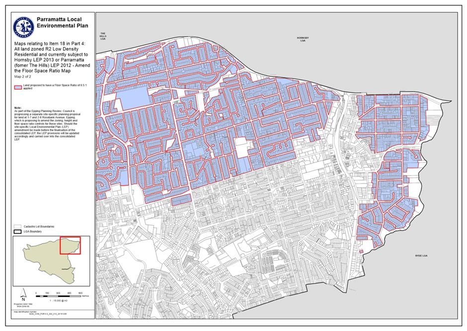
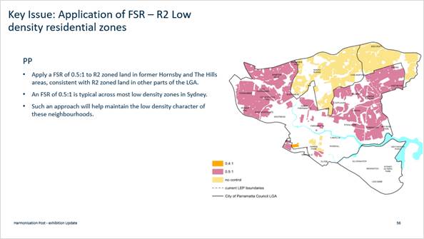
· General concerns with overdevelopment and proliferation of dual occupancy development.
· Concerns over disruption and noise from construction.
· Concerns about loss of tree and impacts on wildlife.
· Concerns about impacts on privacy, solar access, amenity and general quality of life.
Response
26. Council prepared as part of the Harmonisation PP process (following the Discussion Paper) a dual occupancy constraints analysis which mapped and considered: areas with special character; narrow streets; areas lacking permeability; access to public transport; tree coverage; bushfire hazard; and site availability. This constraints analysis:
“…identified much of the low density residential land in Beecroft, Carlingford, Epping, North Rocks, Northmead, Oatlands and Winston Hills as having a high level of constraints to dual occupancy development. Parts of Dundas and Dundas Valley were also identified as having constrained land…” (refer to Council’s Local Housing Strategy, Section 2.7, p.72 at).
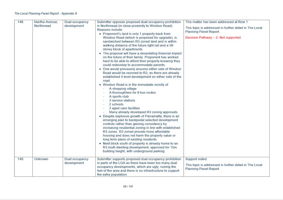
27. Regarding future housing supply, Section 2.2.2 in the LHS details how background housing growth (outside growth precincts) was calculated:
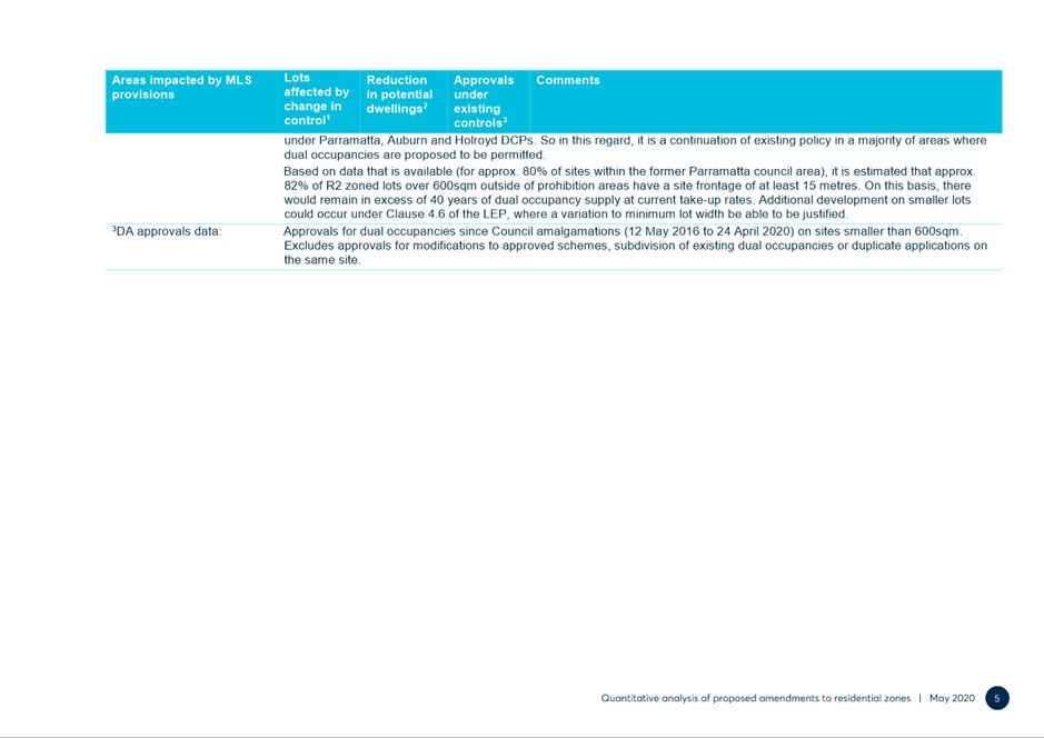
“…For all land in an R2 Low Density zone, where the lot size is above 600sqm, it is assumed there is potential for an additional dwelling in the form of a dual occupancy, except where dual occupancies are prohibited. Prohibition areas proposed as part of the Harmonisation Planning Proposal were utilised to calculate capacity for this form of housing delivery, informed by data on approvals between July 2016 – November 2019. … It is noted that in areas where dual occupancies are prohibited, secondary dwellings remain permissible on sites as small as 450sqm under the provisions of the SEPP Affordable Rental Housing 2009.
For R3 Medium Density land, dwelling capacity was undertaken …to account for the coming introduction of the Low Rise Medium Density Housing Code….”
28. Furthermore, Section 2.5 in the LHS has found that there is more than 50 years of land supply for dual occupancy development:
29. Dual occupancy development, in the right locations, can provide further housing opportunities for families. Taking into account the proposals of the Harmonisation PP, there will remain a theoretical capacity for approximately 8,245 additional dwellings through dual occupancy development on R2 Low Density Residential zoned land, though it is noted that historically R3 zoned land has also been a supply of dual occupancy development (c. 8 dwellings per year). At current rates of take-up (c. 160 dwellings per year in total, and 154 dwellings per year on R2 zoned land), there would remain more than 50 years of land supply (LHS, Section 2.5, p.64).
30. Considering the very high level of housing delivery in the LGA (for example above the DPIE targets for the Parramatta LGA), the LHS states that instead of expanding dual occupancy use within the LGA, further housing diversity with innovative options for households with children, should be explored in the future Growth Precincts (which includes area such as the CBD, North Parramatta, Telopea and Melrose Park) for hybrid townhouse/residential flat building forms. This could also serve to offer better transitions to neighboring lower density zones (LHS, Section 2.5, p.64).
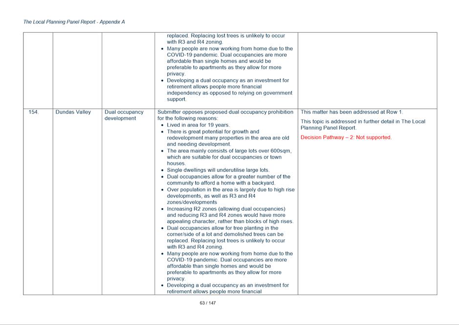
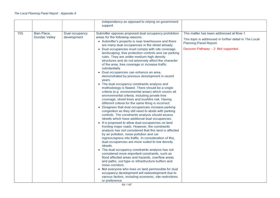
31. The strategic position proposed regarding dual occupancies within the Harmonisation Planning Proposal and Draft LEP is consistent with Council’s endorsed LHS. None of the issues raised in submissions suggesting the prohibitions on dual occupancy should be relaxed provide sufficient justification for Council to move away from its current position.
Key Issue 1b - Dual Occupancy Prohibition in part of Winston Hills
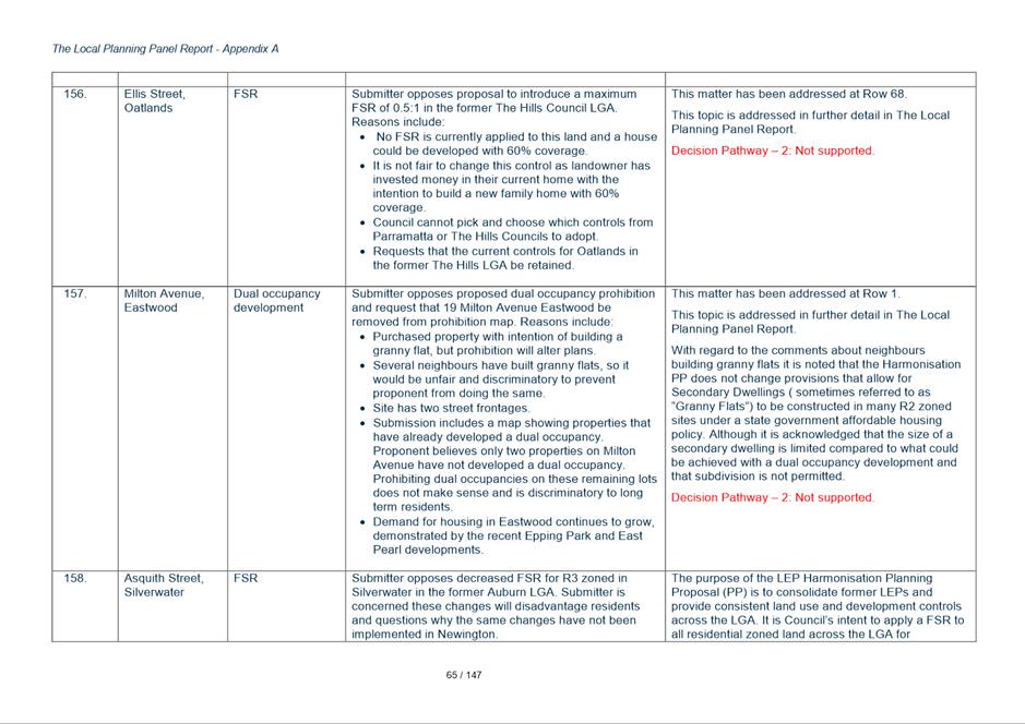
33. Within the area outlined in yellow the sites coloured green are those where dual occupancy would be permitted. The sites shown in salmon colour are sites where dual occupancy would not be permitted because the site does not meet the minimum lots size requirement of 600sqm.
Figure 3 - East Winston Hills Dual Occupancy Prohibition and Permissibility Areas
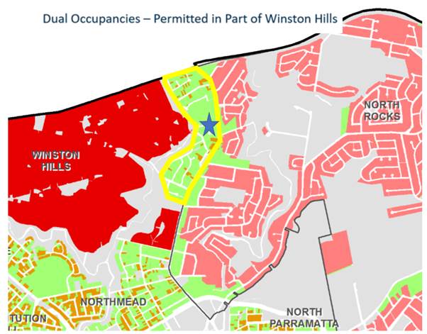
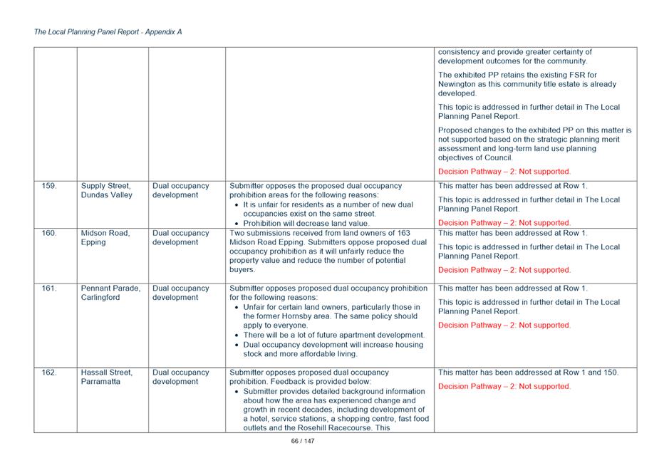
34. As can be seen in Attachment 14 the submissions seeking to have dual occupancy prohibited are all concentrated in an area in the middle of this precinct where the blue star is located in Figure 3 above and in more detail in Figure 4 below. The reasons for requesting the prohibition be extended to this area is due to concerns about amenity impacts on adjoining residents including traffic and parking issues.
Figure 4 - East Winston Hills Dual Occupancy Prohibition and Permissibility Areas
Response
35. The results of the constraints mapping did not result in a decision to prohibit dual occupancy development in this area shown in the extract. The constraints mapping looked at a range of issues including built form character, potential for on-street parking problems, tree cover, lot size and access to public transport in determining whether an area was constrained or not. The areas where the submissions are concentrated were not identified as a constrained area. Whilst it is acknowledged that introducing dual occupancy in an area does have impacts, the precinct where the submissions were lodged was not assessed as highly constrained and therefore is capable of accommodating dual occupancy without unacceptable impacts. It is noted that some dual occupancy has already occurred in the area (as it is currently permitted under the existing LEP provisions). Therefore no change is proposed to the exhibited controls.
Key Issue 1c - Dual Occupancy Prohibition in Heritage Conservation Areas (HCAs)
36. The exhibited Harmonisation Planning Proposal seeks to prohibit dual occupancy development in all Heritage Conservation Areas, (HCAs) with the exception of the South Parramatta HCA which has had precinct specific controls recently developed and implemented to make sure dual occupancy is introduced in a sensitive manner. This affects approximately 150 properties.
37. Eight submissions were received objecting to this policy. The arguments put forward for why Council should allow dual occupancy in Heritage Conservation Areas are the same as those listed under the heading 1a to justify dual occupancy prohibitions across the entire LGA being relaxed.
38. Dual occupancy prohibition is being pursued to assist with retention of the special character of these HCAs.
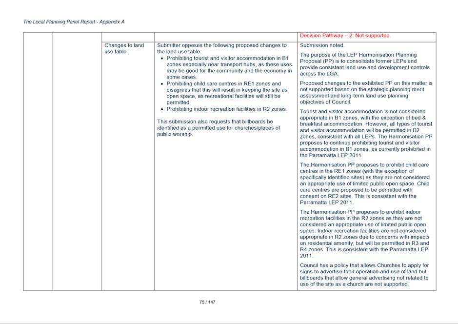
Response
39. The LEP Harmonisation PP primarily proposes to continue prohibiting dual occupancy development where it is currently prohibited under existing LEP controls. However, as part of the Harmonisation Planning Proposal a dual occupancy constraints analysis was undertaken which considered: areas with special character; Narrow Streets; areas lacking permeability; access to public transport; tree coverage; bushfire hazard; and site availability.
40. Section 2.1 of the dual occupancy constraints analysis identified that existing Heritage Conservation Areas (with the exception of South Parramatta Conservation Area, where special local provisions have recently been applied through a site-specific rezoning process) have special character that is to be protected.
41. The heritage value of a conservation area lies not just with the heritage significance of individual buildings, but with other factors, including landform, subdivision and the history of development. For many areas the changes to the streetscape and subdivision as a result of dual occupancy development would not be compatible with the heritage significance of these areas. Beecroft and Epping were also identified as potential special character areas.
42. Proposed changes to the exhibited PP on this matter is not supported based on this strategic planning merit assessment and long-term land use planning objectives of Council.
Key Issue 1d - Dual Occupancy Prohibition based on a Minimum Lot Size of 600sqm
43. The exhibited PP mapped all existing properties less than 600sqm to apply a prohibition on dual occupancy on these sites. Concern in submissions was raised about the accuracy of the mapping and survey data of existing properties. Also concern was raised about mapping lots spatially as ‘prohibiting dual occupancy’ when properties might be subdivided and/or consolidated in the future to result in a different lot size.
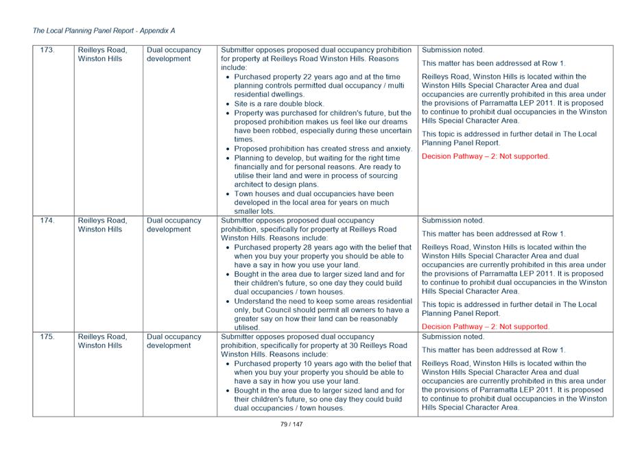
44. Two development industry submissions raised concern that the prohibition of individual lots would preclude the opportunity to consolidate and re-subdivide lots to comply with the Minimum Lot Size control.
45. Various landowners have advised their land which is mapped as less 600sqm is actually larger than 600sqm – therefore incorrectly prohibited from dual occupancy development.
46. Concern is raised that the mapping process for identifying lots as less than 600sqm on the prohibition map may be reliant on inaccurate data and be prohibiting dual occupancy development on lots that would comply with the 600sqm control. One submission suggests Council rely on a clause limiting dual occupancy on 600sqm sites rather than seeking to prohibit them by showing sites on a map.
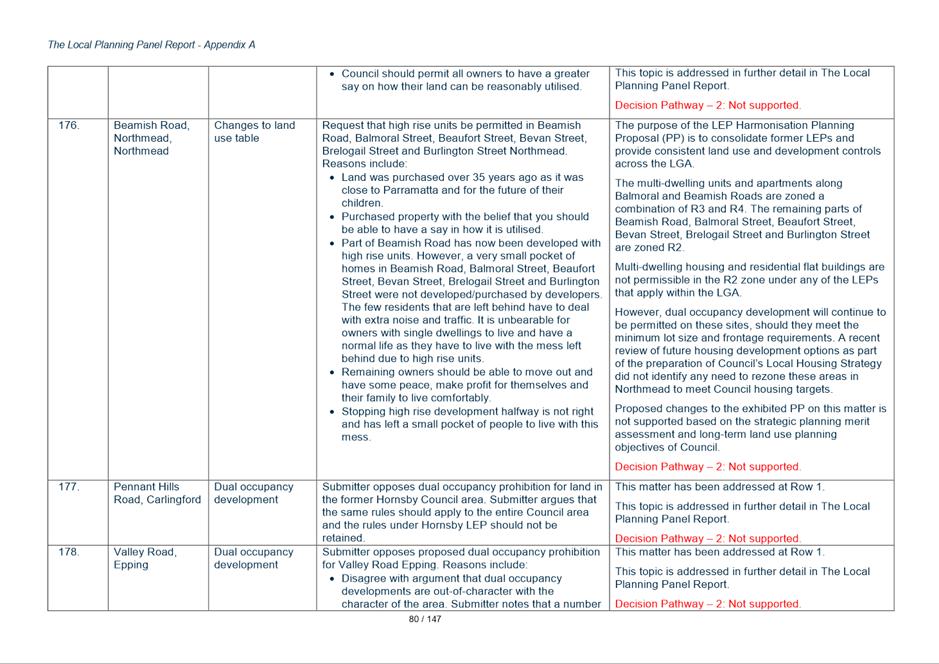
Response
47. If the circumstances above apply and the sites are incorrectly mapped, land owners would be required to submit a planning proposal to amend the LEP mapping and Council would have no policy justification to refuse the application. Requiring this process would be inefficient for both the applicant and Council in these circumstances.
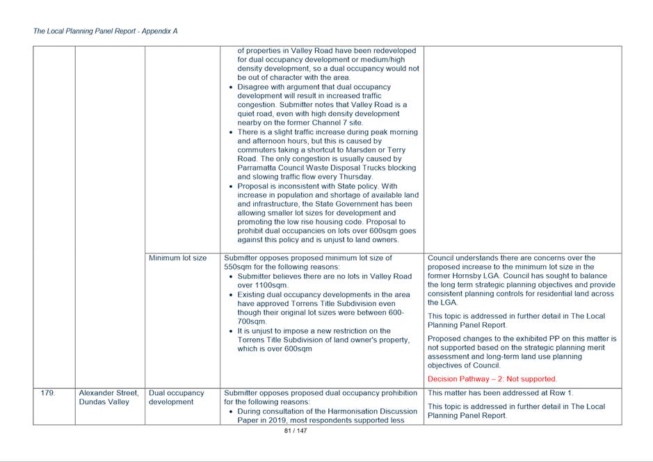
48. It is therefore recommended that the intended prohibition of dual occupancy on lots less than 600sqm remains as per the public exhibition however the mapping of sites with an area of less than 600sqm will be deleted. Clause 4.1D as exhibited is a written clause that achieves the same function, and which also allows for change in lot sizes and other circumstances over time.
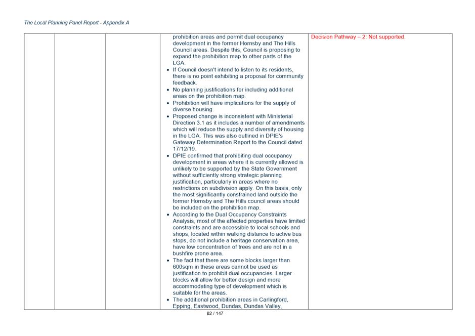
49. Ideally, the standard LEP Clause 4.6 – Variation to Development Standards would be modified to strengthen the dual occupancy restriction however written advice from DPIE has indicated (during the Gateway extension) that modifying Clause 4.6 would not be supported by DPIE.
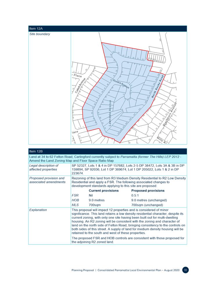
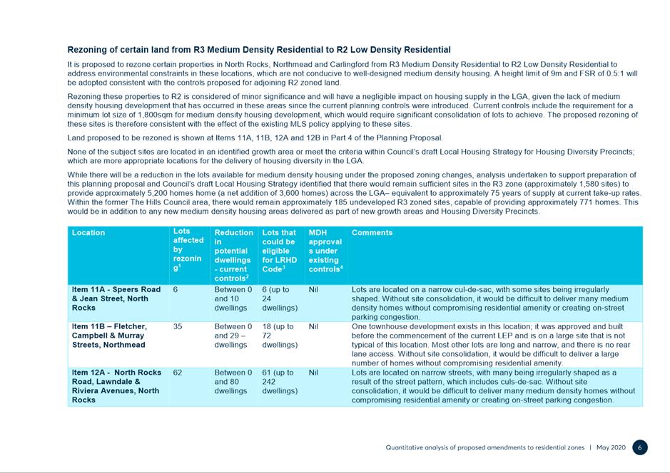
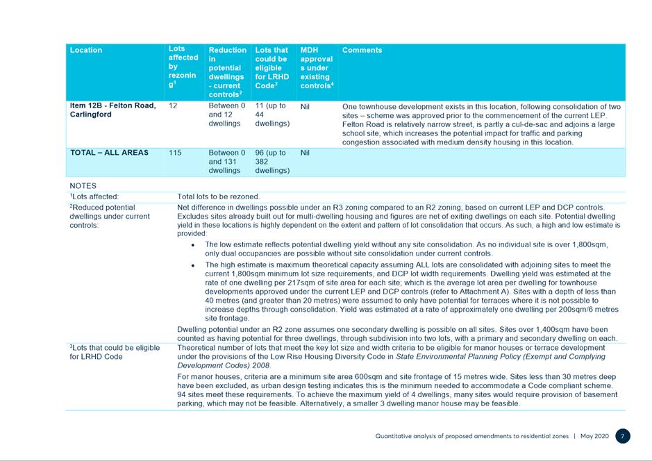
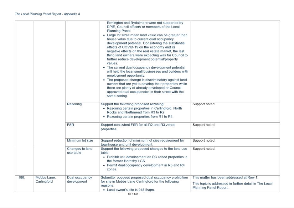
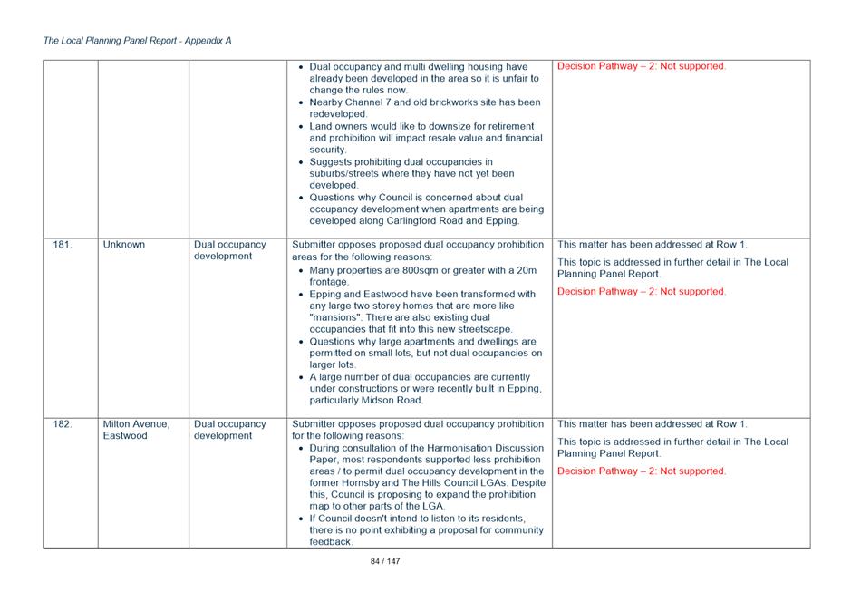
Key Issue 2 - Rezoning in Northmead and Carlingford from R3 (Medium Density Residential) to R2 (Low Density Residential).
50. Figure 5 below shows the location of two precincts where the Draft Harmonisation PP seeks to downzone the sites from Residential R3 to Residential R2.
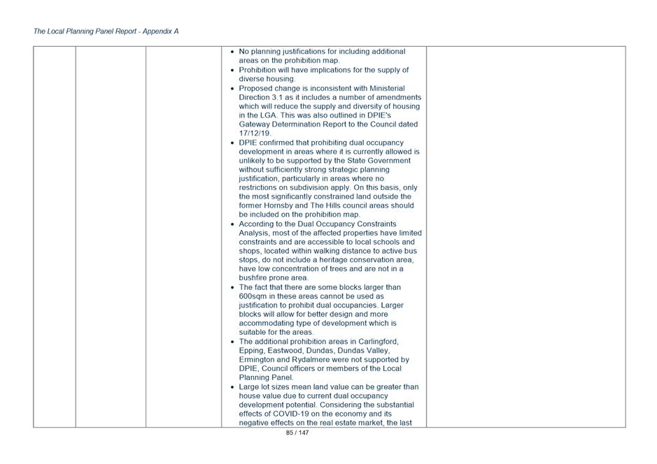
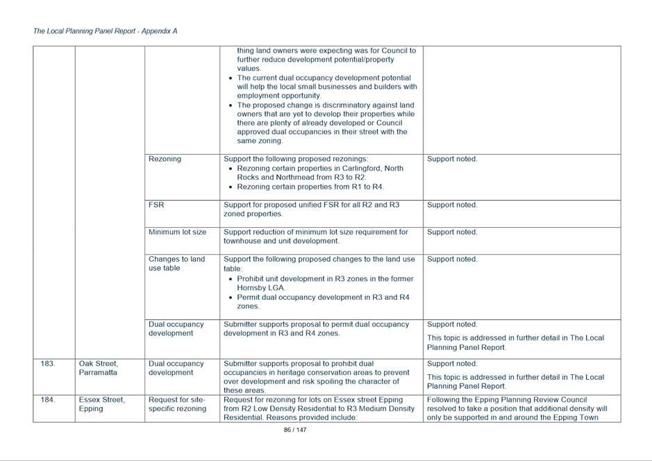
Figure 5 - R2 Low Density Residential (and Dual Occupancy Prohibition) area - Northmead and Carlingford
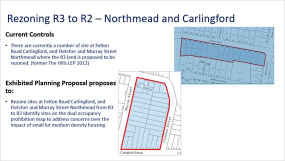
51. At Felton Road the intent is to make the density consistent with the density on the northern side of Felton Road and to retain the character on both sides of Felton Road given that only one site on the southern side has been developed.
52. At Murray Street the concern is that the deep blocks do not produce ideal urban design outcomes. The precinct already contains other R3 Medium Density and R4 High Density sites that have been developed. The broader precinct also has limited road network permeability with all access via Windsor Road which contributes to traffic congestion issues.
53. The submissions of objections overall (8 of the 19 submissions received) cite concerns about loss of value of their property, issues about land value and reduction in development potential are acknowledged but if Council’s objective of maintaining consistency in controls on both sides of Felton Road are to be achieved the objections cannot be supported.
54. At Felton Road Carlingford, most affected landowners oppose the rezoning and inclusion on the dual occupancy prohibition map.
55. At Fletcher and Murray Street, Northmead, two owners object to the rezoning and one landowner supports the rezoning.
56. Key concerns raised in these submissions are:
• Devaluing owners land
• Unfairness due to owners paying ‘R3 level Council rates’
• Arguments that other areas have medium density on one side of the road and single dwelling zone on the other
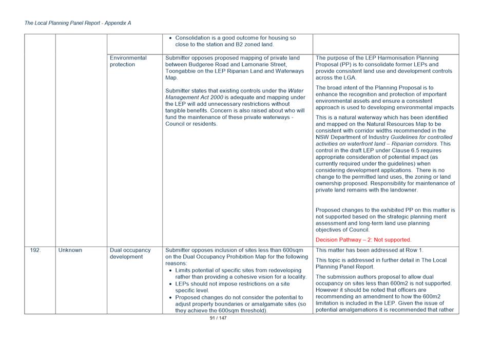
• Restriction of development options given the need to provide for increasing housing close to public transport
• One site in area to be rezoned has already been developed for townhouse and so this should be seen as a precedent for the others to be permitted the same development.
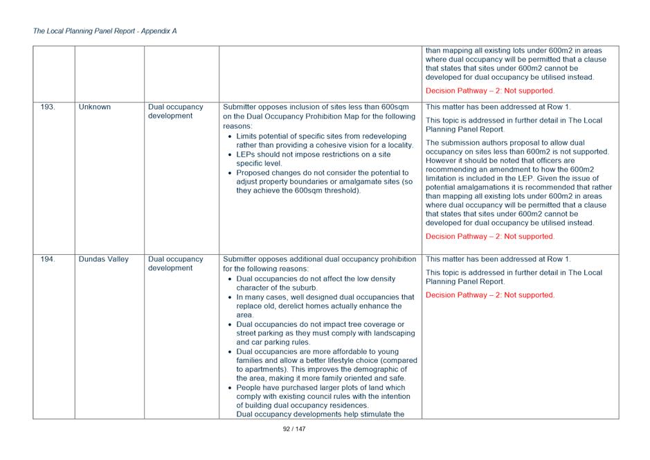
Response
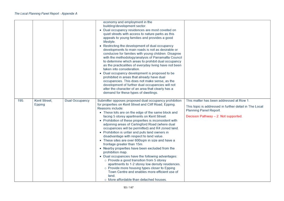
57. Whist the impact on the redevelopment potential and possible land value is noted the submissions do not raise any issues that warrant Council amending its planning policy position for these areas.
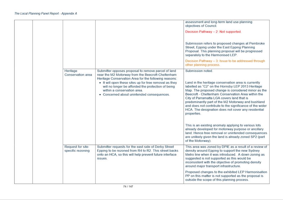
Key Issue 3A – Heritage Listing on Large Sites
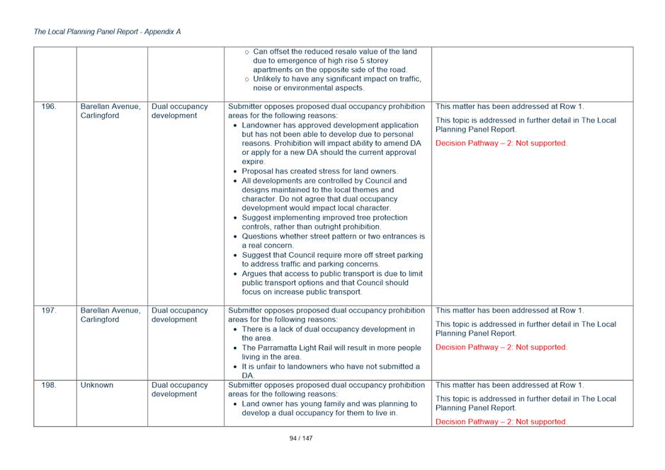
58. Three landowners have requested Council reconsider the way heritage items are shown in the LEP. In these cases there are heritage items located on large sites and the entire site is shown as the listed heritage site.
59. This has impacts for how development occurs on parts of the site away from the heritage item as exempt and complying development cannot be pursued on any listed site. This means any development/changes on those parts of the site must pursue the more time consuming and costly development approval path
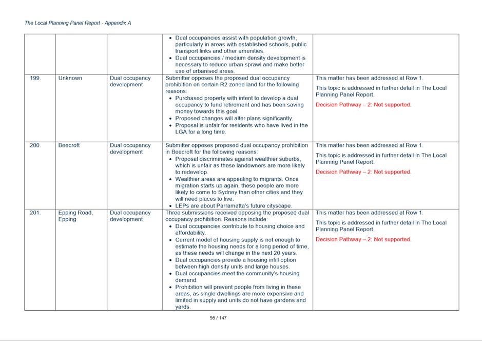
Response
60. It is normal practice for the lot containing a heritage item to be identified in the LEP Heritage Schedule by the lot and DP containing the site and for the entire lot to then be shown on the Heritage Map as the location of a heritage item.
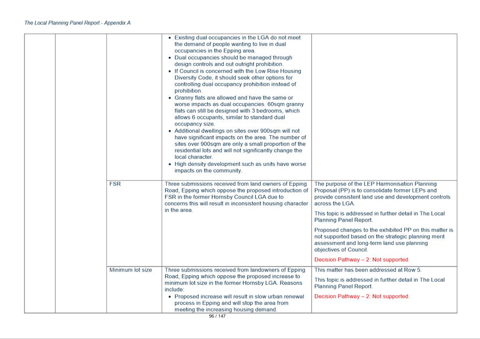
61. It is acknowledged that where a heritage item is located on a very large lot that this designates the entire lot as a heritage site for the purpose of development assessment, and that this can in some cases lead to heritage assessments being required for minor development that have minimal impact on the heritage item that may be also located on another part of the site.
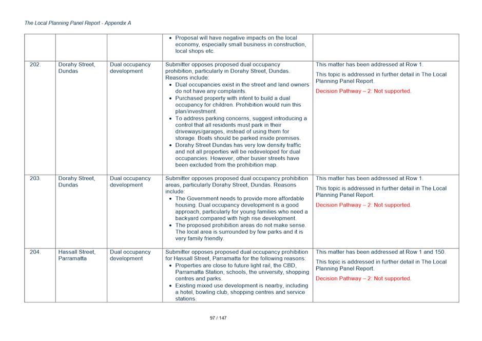
62. Another issue is that exempt and complying development that cannot be carried out on heritage sites must be approved via a development application process even if they are located well away from the heritage item.
63. Given this there have been precedents for only parts of lots to be shown as the listed heritage item.
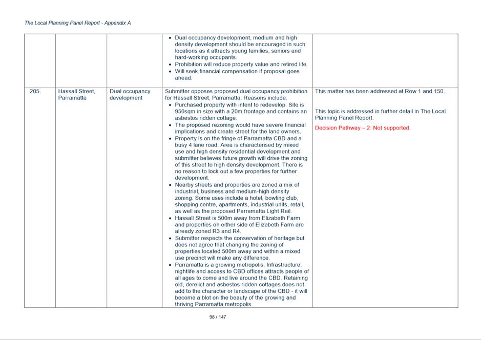
64. However, pursuing this pathway does require some analysis. Showing just the building itself as the heritage listed portion of the site may not be appropriate in many cases because development adjoining the item and views to and from the item must also be taken into account.
65. If part of the site is to be shown as the heritage listed area Council must be confident that the area selected is an accurate presentation of the heritage item and its curtilage which often is also significant in ensuring the item can be interpreted in its proper context.
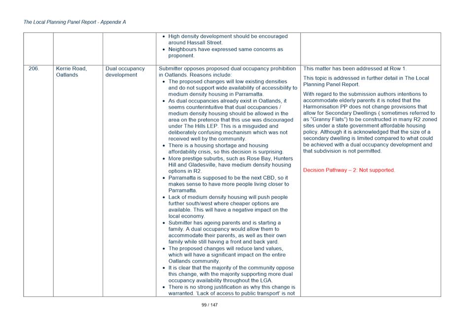
66. Council Officers are supportive of the proposal to review the area of land shown as the listed area in principle but recommend that the process of determining the proper heritage curtilage and amending the LEP be undertaken as a separate process.
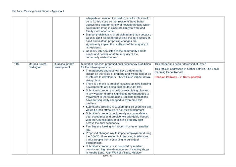
67. The intention of the Harmonisation Process is to consolidate the various instruments that apply. Making changes to listed items is not consistent with the scope of this project. Including the proposal at this point in time would also require re-exhibition of the plan which would delay finalisation of the Harmonisation Planning Proposal.
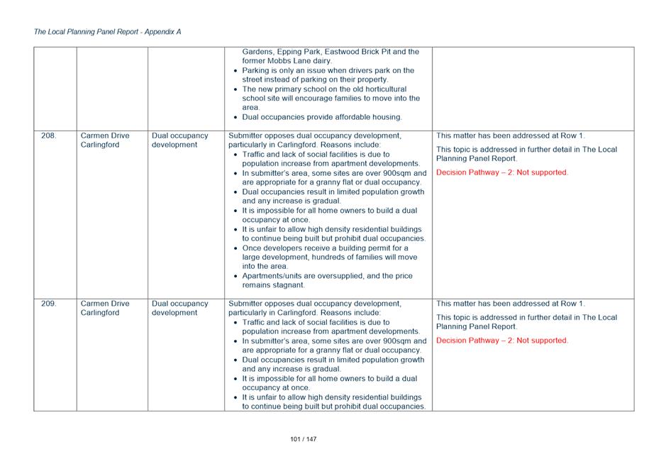
68. In some cases (Kings Schools submission for example) a heritage assessment has been provided. In cases where the assessment has not been completed it would be the responsibility of the owner to do so to justify what the heritage curtilage of the item should be. Landowners can either pursue a site specific Planning Proposal supported by their heritage study or submit it to Council for potential inclusion in a future LEP Housekeeping Amendment process.
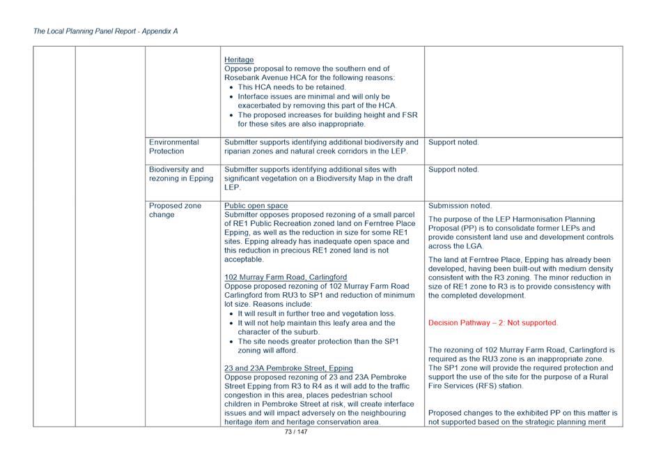
69. Key Issue 3b - Biodiversity Mapping of Key Sites
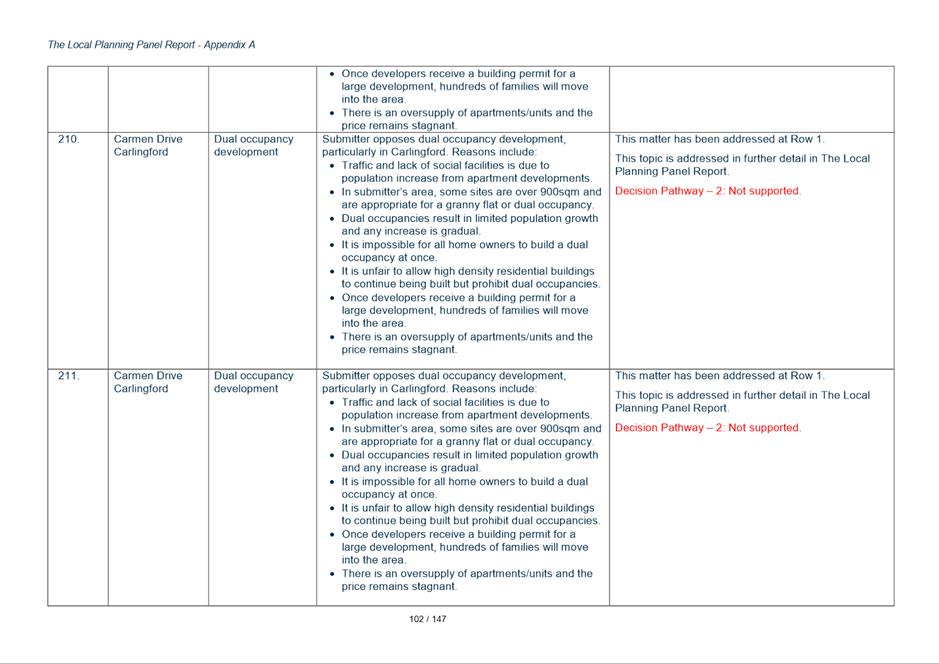
70. Two of the same landowners of large sites have raised a similar issue in relation to the impact that the biodiversity designated land has on their ability to develop their sites. Areas shown to be within the biodiversity areas on the relevant LEP Map can in theory still be developed, but they need to go through the development approval process to ensure a proper assessment of the biodiversity issues is addressed. More streamlined approval processes for development such as exempt or complying development cannot be pursued.
71. The submission authors question whether the areas mapped on their sites are of sufficient biodiversity value to warrant their inclusion on the map.
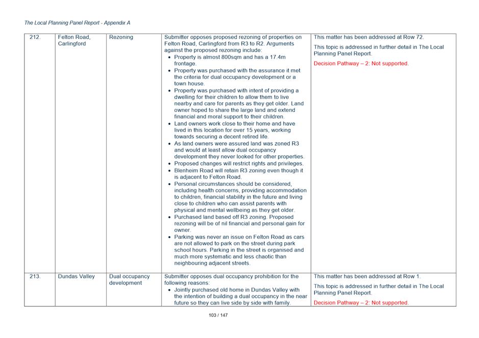
Response
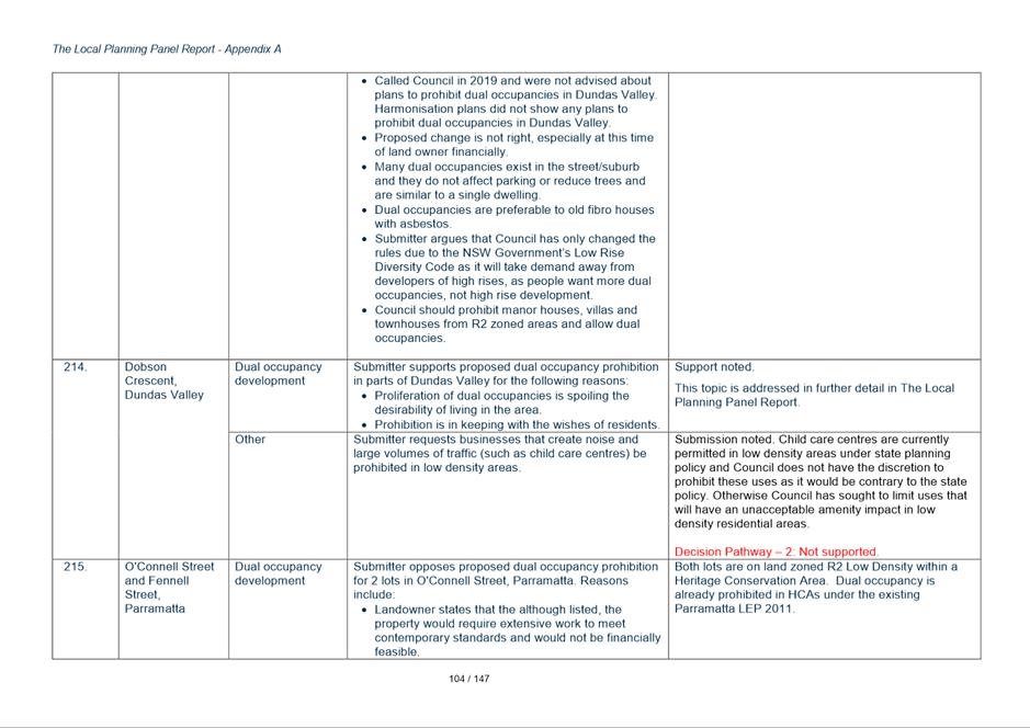
72. Council Officers are supportive of a review of the exhibited Biodiversity Map but to avoid delay to the Harmonisation Planning Proposal are recommending this be considered as a separate planning process.
73. In some cases (Kings Schools submission for example) a heritage assessment has been provided. In cases where the assessment has not been completed it would be the responsibility of the owner to do so to justify what the heritage curtilage of the item should be. Landowners can either pursue a site specific Planning Proposal supported by their heritage study or submit it to Council for potential inclusion in a future LEP Housekeeping Amendment process.
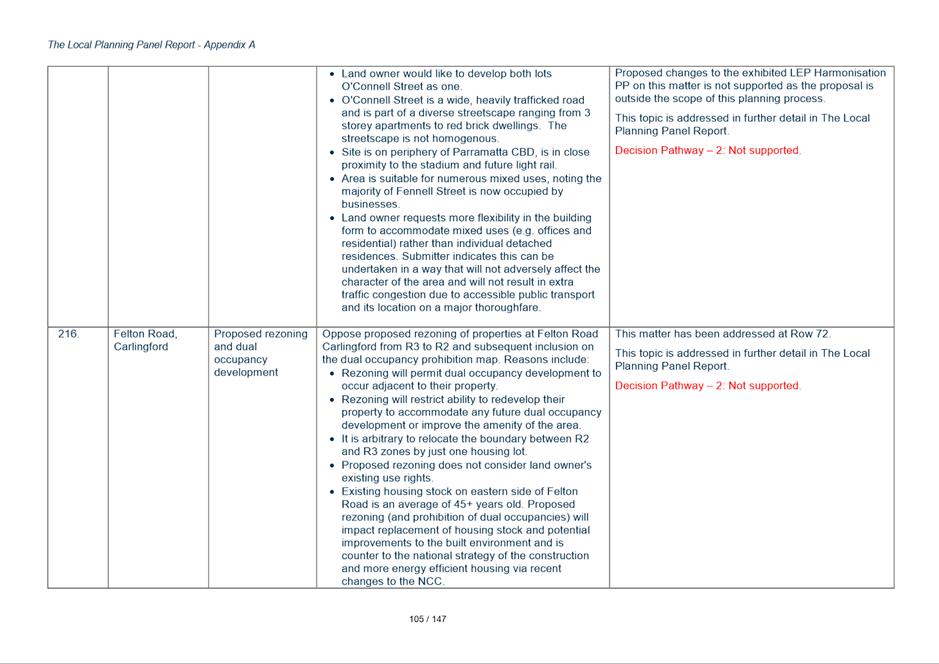
74. Immediate changes to the Plan as part of the Harmonisation Planning Proposal would require re-exhibition of the Harmonisation Plan which is not recommended.
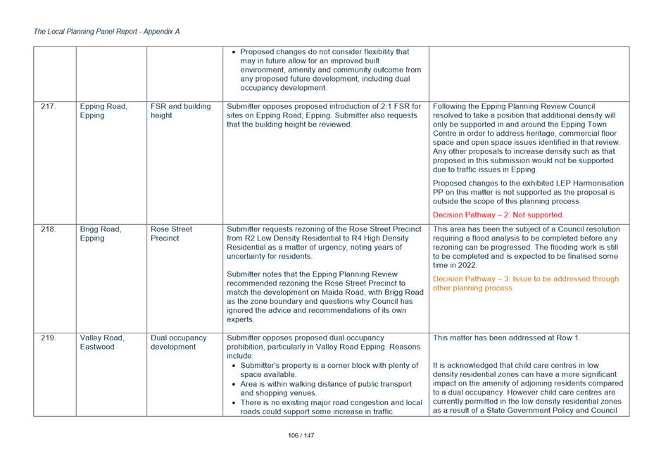
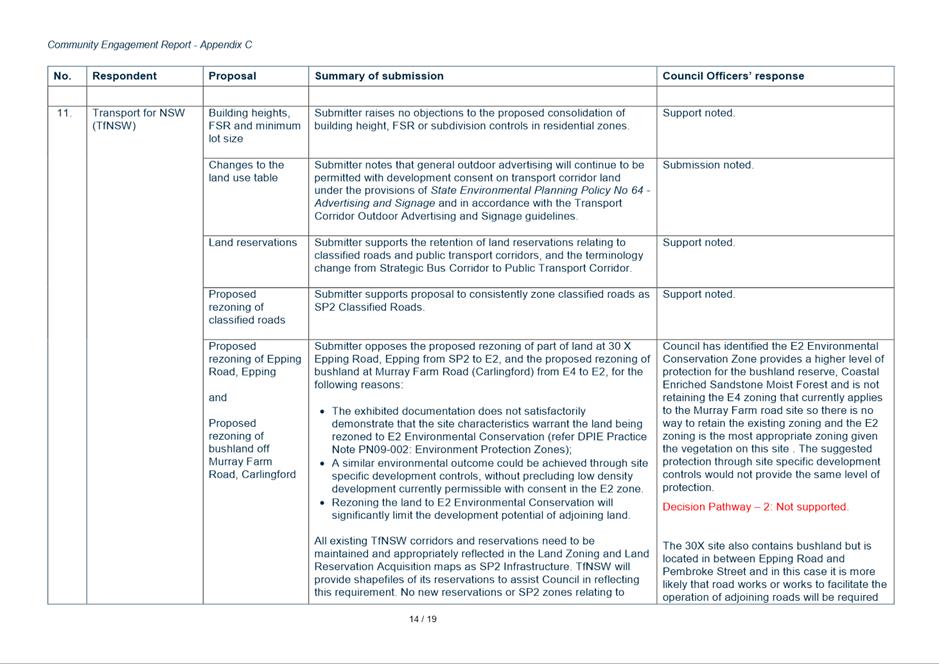
Key Issue 4 Rezoning of Transport for NSW (TfNSW) owned Environmental Protection Sites
75. The exhibited Harmonisation Planning Proposal proposes:
• At 30X Epping Road Epping - rezone land from SP2 to E2
• A bushland site off Murray Farm Road abutting M2 Motorway - rezone land from E4 to E2.
76. TfNSW opposes these rezonings and this could be considered an unresolved agency objection which may need to be ultimately determined by DPIE. TfNSW claims Council has not satisfactorily demonstrated the sites warrant the land being rezoned to E2. And is also concerned that rezoning the land would limit the development potential of the land to which it adjoins.
Response
77. The sites are both bushland sites containing Coastal Enriched Sandstone Moist Forest vegetation communities.
78. Council is not proposing to retain the E4 Environmental Living zone that exists in the Hills LEP and applies to the Murray Farm Road site so the site must transition to another zone and the E2 zoning is the most appropriate alternative given the site is covered in dense vegetation, and the fact that TfNSW has not identified an alternate use or potential zoning.
79. The Epping Road site is zoned as SP2 Road Reservation and sits between two road corridors (Pembroke St and Epping Road). Given the TfNSW objection it can only be assumed there remains some potential future need for road widening or works associated with the road network located on either side of this site. It has little practical potential for other uses. If TfNSW does propose any works related to the road network on this site (for example, improved drainage arrangements or further road widening) in this bushland area they will still be required to assess the environmental impacts, and so if this is the case the SP2 zoning that currently applies is the appropriate zoning. It is recommended that the Planning Proposal be amended and the SP2 zoning be retained for this site. Retaining a site at its current zoning is not an amendment to the exhibited Planning Proposal that would warrant re-exhibition.
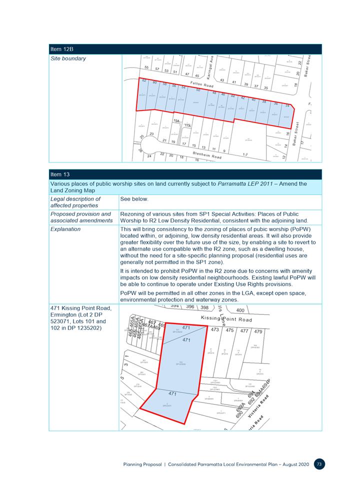
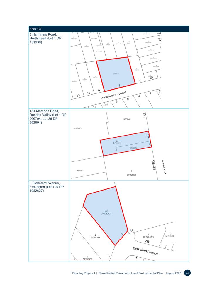
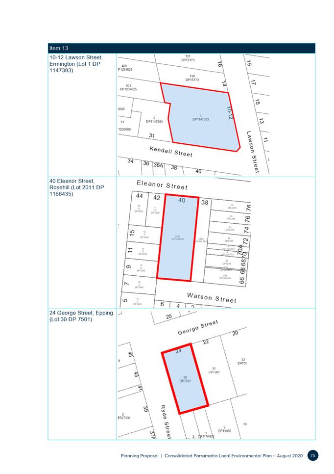
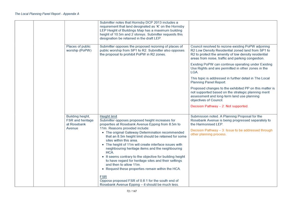
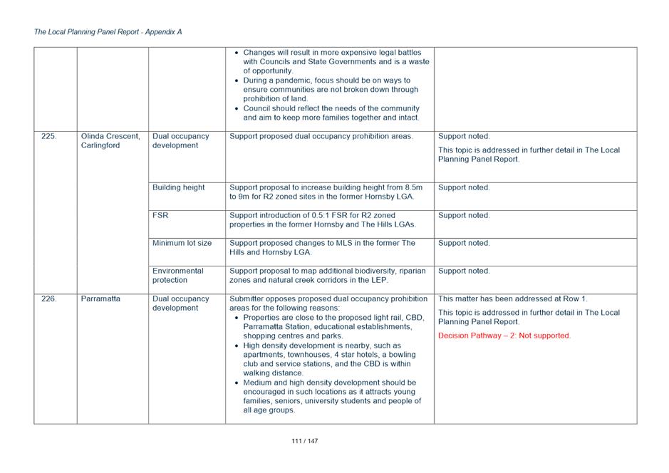
Key Issue 5 - Places of Public Worship
80. The PP proposes to prohibit Places of Public Worship (POPW) in the R2 Low Density Residential zone. Further, it proposes that existing POPWs that are located in the former City of Parramatta LEP area and which are currently zoned SP1 Special Activities be rezoned R2.
81. This change means that POPW that operate in low density zones will continue to operate under existing use rights provisions which allow for some change to or expansion of the use subject to a merit assessment.
82. Six (6) submissions were received (5 land owners, 1 from an industry body) which raise the following issues:-
· Oppose the rezoning of PoPW from SP1 to R2
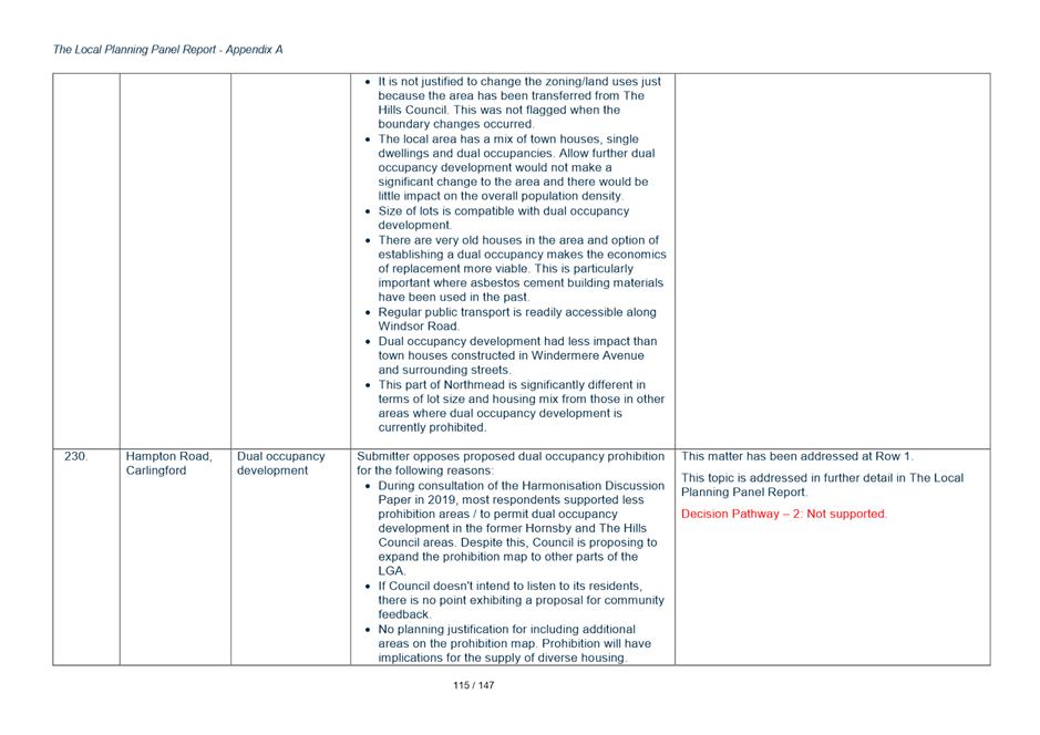
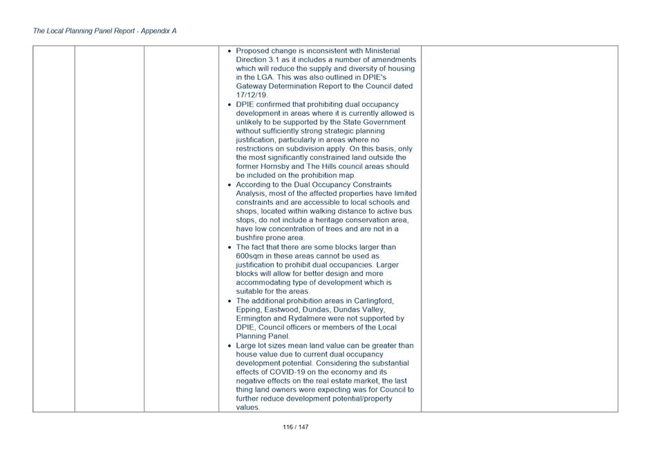
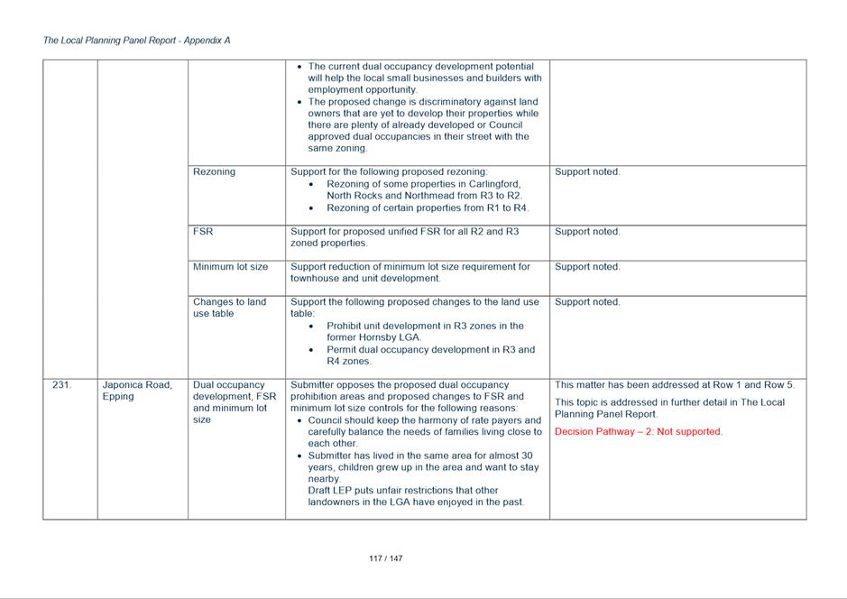
· Oppose the prohibition of PoPW in R2 zone
· Support the rezoning of SP1 to R2 but only subject to PoPW being permitted with consent in R2 zone
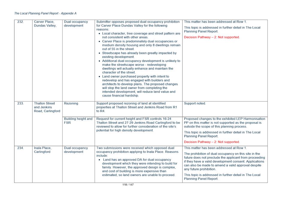
· Claims unfair and impacts on the ongoing viability and growth options for existing PoPW to rely upon Existing Use Rights. Request for existing sites to be identified in the Additional Permitted Use (APU) Schedule in LEP (as per old DPIE circular).
Response
83. The Council policy position on this issue is driven by concerns about the amenity impacts of Places of Public Worship in Low Density Residential Zones.
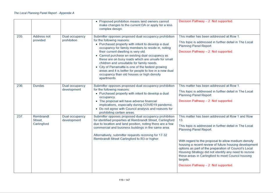
84. The prohibition on POPW in the R2 zone seeks to ensure that these uses are encouraged to find more appropriate locations and that existing operating POPWs can only expand their operations on the sites they currently occupy under existing use rights provisions.
85. The proposal to rezone existing sites from SP1 to R2 seeks to make it easier for these sites to transition to a more appropriate use should they cease to operate in the future. If the current SP1 zone is retained these sites would need to be rezoned if there is an opportunity to transition to some more appropriate residential use in the future. The controls proposed seek to make it as easy as possible for these sites to transition to sites more appropriate to their operation away from low density residential neighbourhoods.
86. The submissions objecting generally raise concerns about the impact this may have on their operations and opportunities to expand but none have been able to address Council’s underlying concern over their impact on the amenity in low density precincts. In this context no amendments to the exhibited controls are recommended.
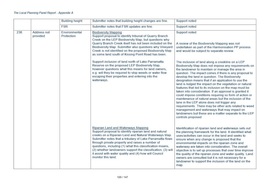
Key Issue 6 – Permissibility of Advertising Structures
87. Exhibited Planning Proposal proposes to prohibit general advertising structures in all zones in the LGA, consistent with the current approaches under both Parramatta LEP 2011 and Parramatta (former The Hills) LEP 2012.
.
88. A submission was received from the Outdoor Media Association discussing:
• Impact of changes on advertising industry
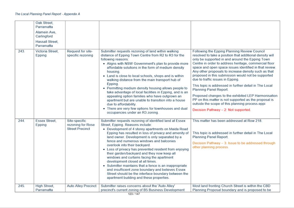
• Applications/licences for existing signage will not be renewed
• Prohibition will impact upon local areas as advertising structures promote local of goods and services
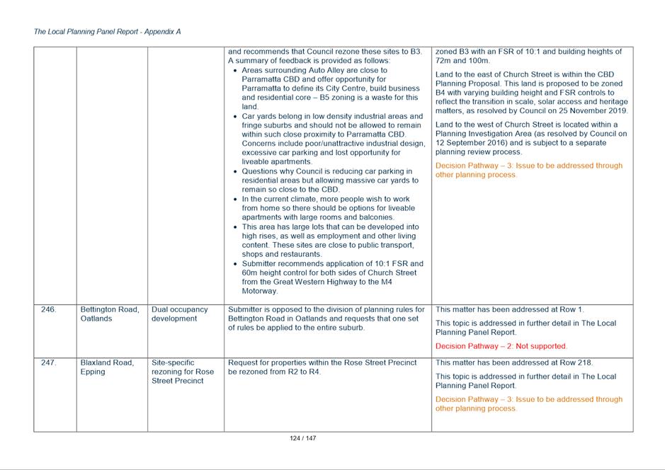
• The association provided their own analysis to seek to justify their position that the LGA should be opened up to permit more advertising.
Response
89. General advertising which does not relate to the specific use of a site is not considered appropriate due to visual impact and concerns about visual clutter. While the applicant has argued that the role of advertising is important and modern advertising adds value to the community Council should not pursue any change to their policy position without undertaking its own independent analysis.
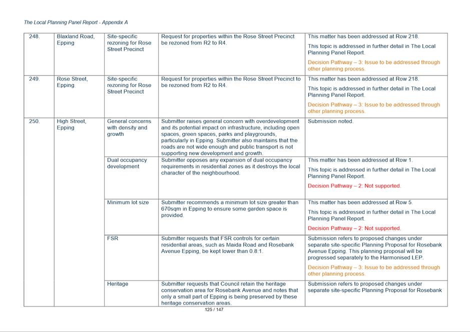
90. The provisions of SEPP 64 will continue to apply to building and business identification signage, which will continue to be permitted, and the display of advertisements on transport corridor land is also covered by this policy.
91. The draft Parramatta LEP proposes to identify advertising on bus shelters owned or managed by Council as exempt development under Schedule 2.
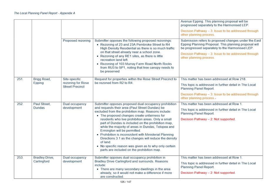
92. Existing approved advertising structures can be considered under the EPA Act and EP&A Regulation which contain provisions to assess development applications for lawfully approved existing uses.
93. The objective of the Harmonisation Planning Proposal process is to consolidate five separate policy positions, rather than enter into a debate about what may be considered to be a significant change to the policy position. In this context no change to the exhibited Planning Proposal is recommended.
Key Issue 7 - Development Near Zone Boundaries Clause
94. Each current LEP that applies in the City of Parramatta LGA contains a Clause 5.3 relating to development near zone boundaries. In each of the clauses the former Council has nominated a distance within which uses permitted in a zone can extend into the adjoining zone.
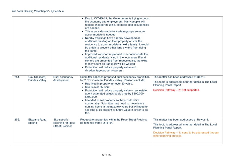
95. Currently the Auburn, The Hills and Hornsby LEPs apply 20m, Holroyd 10m and the City of Parramatta 1m as the distance that uses can extend into an adjoining zone. The exhibited PP proposes to adopt 1m for the whole LGA.
96. A Sydney Trains submission opposes the proposed 1m nominated distance. It claims 1m is too restrictive and prevents application of clause for intended purpose. It recommends 20m instead, consistent with Auburn, The Hills and Hornsby LEPs.
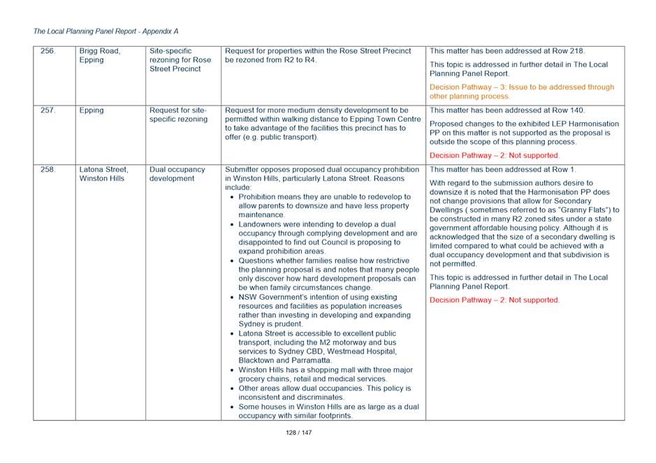
Response
97. The justification put forward in submissions for inserting a greater distance is that it promotes more flexibility in the planning controls along zone boundaries. However, allowing 10m or 20m could inadvertently permit other uses that are inconsistent with strategic intent. The clause is rarely used and allowing it to be used more extensively increases the opportunity for it to be used for purposes inconsistent with Council’s strategic objectives.
98. Council Officers consider that the submission from Sydney Trains alone is not justification for Council to move away from the exhibited position but this might be considered as an unresolved agency submission and DPIE may seek to amend the proposal post Council endorsement if it considers the Sydney Trains submission has merit.
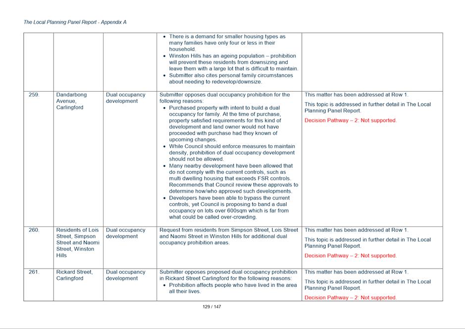
Key Issue 8 - Newington
99. A total of 3 submissions objected to proposed changes to raise the permitted Height of Buildings (HOB) from 9 to 11 metres, apply a standardised FSR and introduce a Minimum Lot Size (MLS) of 550sqm into the suburb of Newington.
100. The submitters raises concern that proposed LEP changes are inconsistent with the Newington Community Title Community Management Statement and the related formal Architectural and Landscaping Standards that underpin the design concept for the suburb.
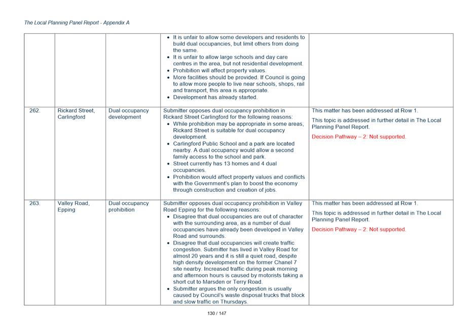
Response
101. Currently there is no LEP minimum lot size control applying to as the lot size controls are within the former Auburn Council DCP.
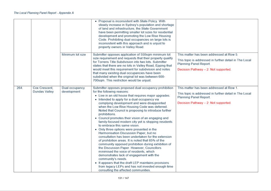
102. The harmonisation proposal changes seek to standardise planning controls and provide consistency across a consolidated Parrramatta LGA. In doing so standard building heights and minimum lot sizes have been proposed to be introduced.
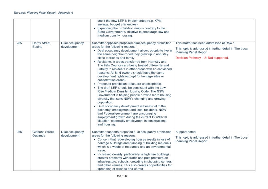
103. Newington has a somewhat unique situation being a large community title subdivision where the development potential has already been realised and the building heights and lot sizes are specific to that community title development. The submissions articulate a concern that by introducing a change in the planning controls there would be a perception that further development is possible contrary to the existing community title provisions.
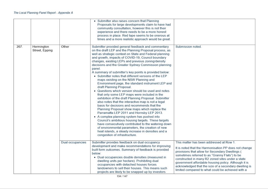
104. The harmonisation of planning controls seeks to provide consistency where possible with existing provisions and introduce planning controls to reflect already endorsed strategic directions. Introducing new planning provisions to Newington could have unintended consequences and create unrealistic expectations for development potential in a ‘completed’ community title estate.
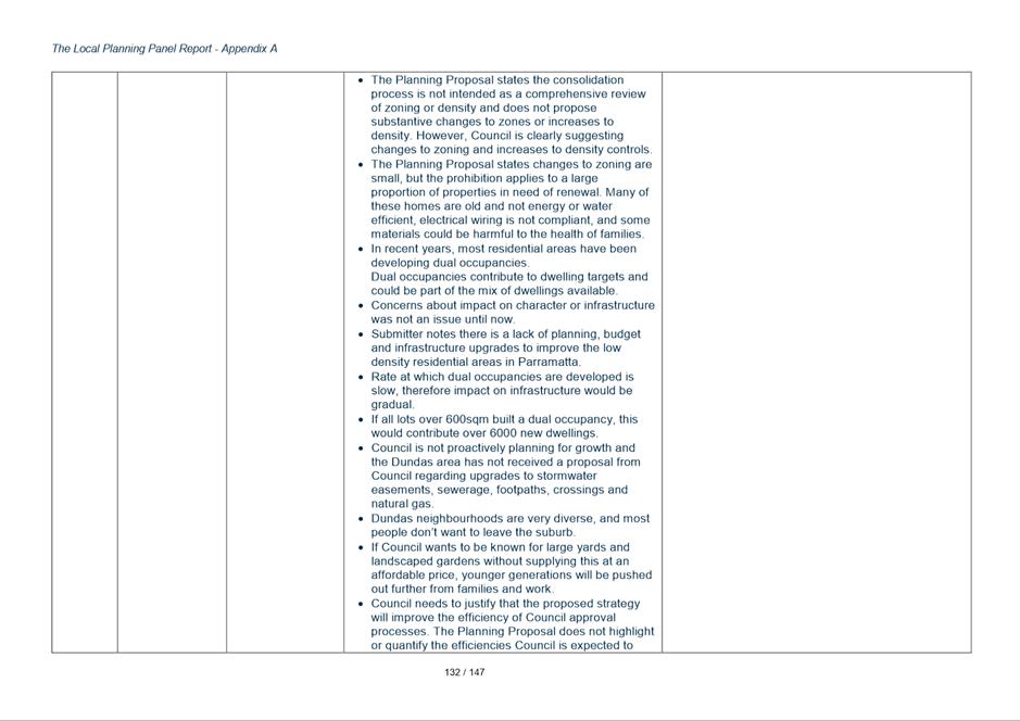
105. The submission is supported and it is recommended that minor changes be made to the Harmonisation PP and draft PLEP to retain the previous controls (under the Auburn LEP) for Newington i.e. a 9 metre height limit, no MLS be introduced to Newington and the existing FSR of 0.75:1 be retained.
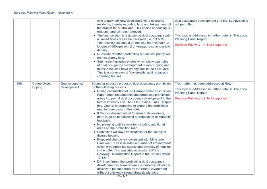
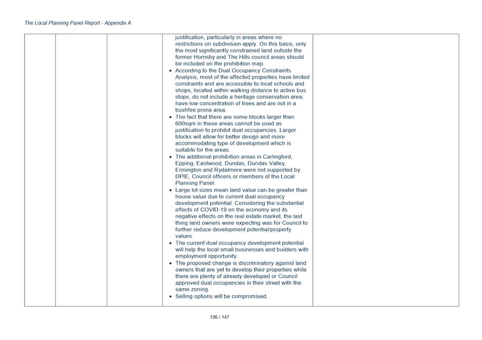
106. It is intended that the proposed harmonisation of the various DCPs into one Parramatta DCP will similarly retain the existing DCP controls applying to Newington’s community title development rather than standardised with LGA wide controls intended for ‘traditional’ Torrens title housing lots and building heights.
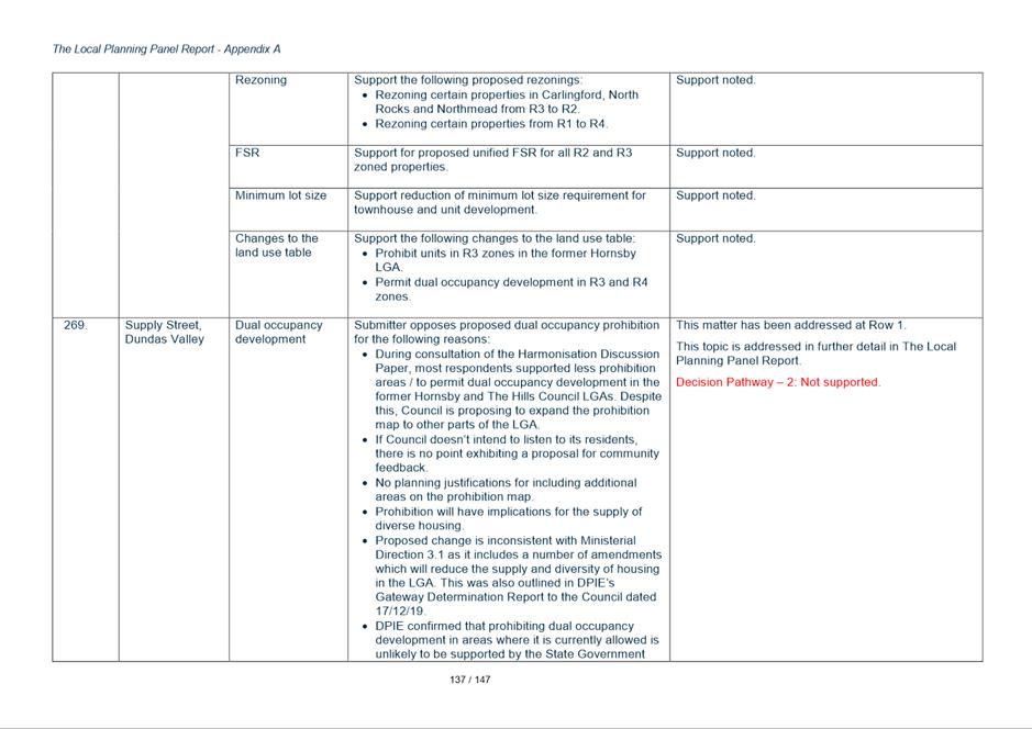
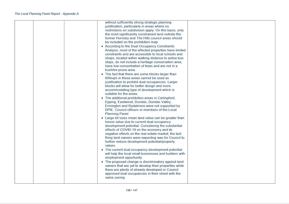
Key Issue 9 - Numbering of State Listed Heritage Items
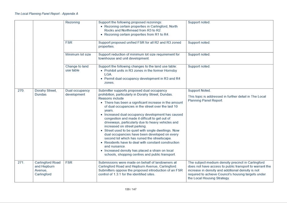
107. The exhibited planning proposal seeks harmonise all listings from all former Councils areas into a single Schedule 5 for the new draft Parramatta LEP including all heritage items.
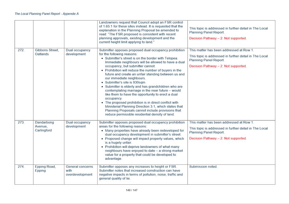
108. Items with State level significance were proposed to be identified using State Heritage Register inventory numbers to avoid having two sets of numbers for the same set of items.
109. However, Heritage NSW do not support item numbers listed in the schedule being the same for both local and state listings. They would prefer that in LEPs State items have their own separate identifier in the LEP and that the State Heritage Register Inventory number not be used in LEPs.
Response
110. In response to this submission the State listed heritage items will be renumbered so they are no longer identified by their State inventory number. This is a minor administrative amendment with no policy implications and does not require re-exhibition of the plan.
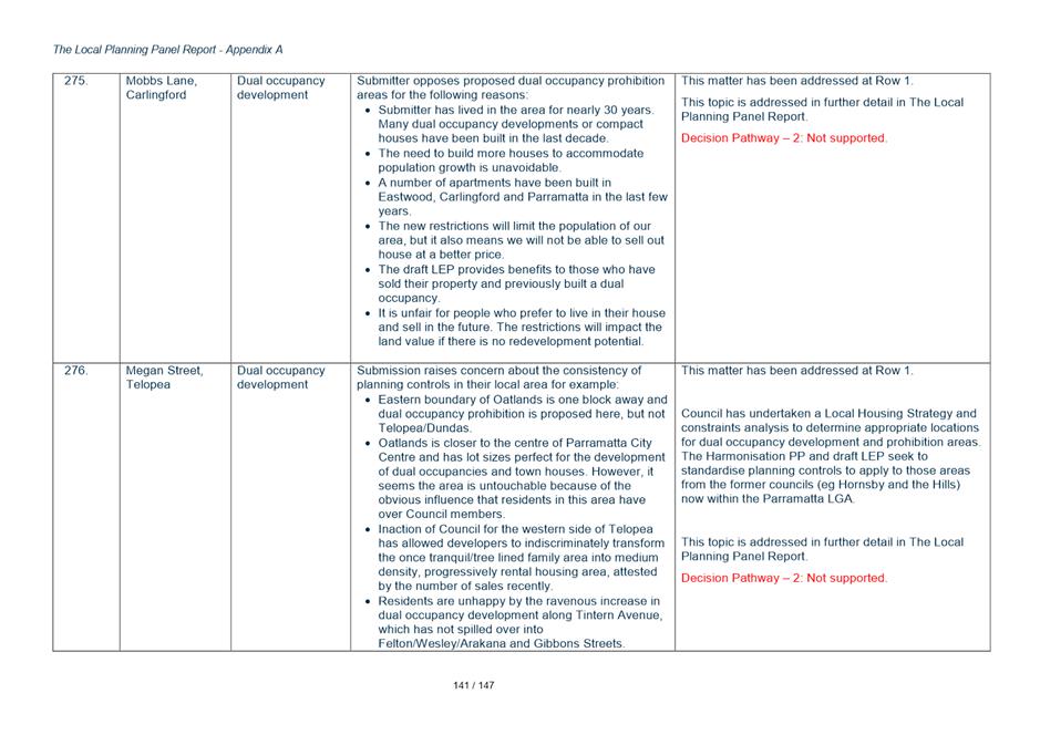
Key Issue 10 – North Rocks Industrial Precinct
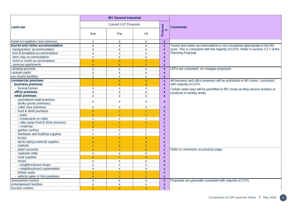
111. The exhibited Planning Proposal proposes to prohibit “child care centres” and “tourist and visitor accommodation” in all IN1 zones including the North Rocks Industrial Precinct.
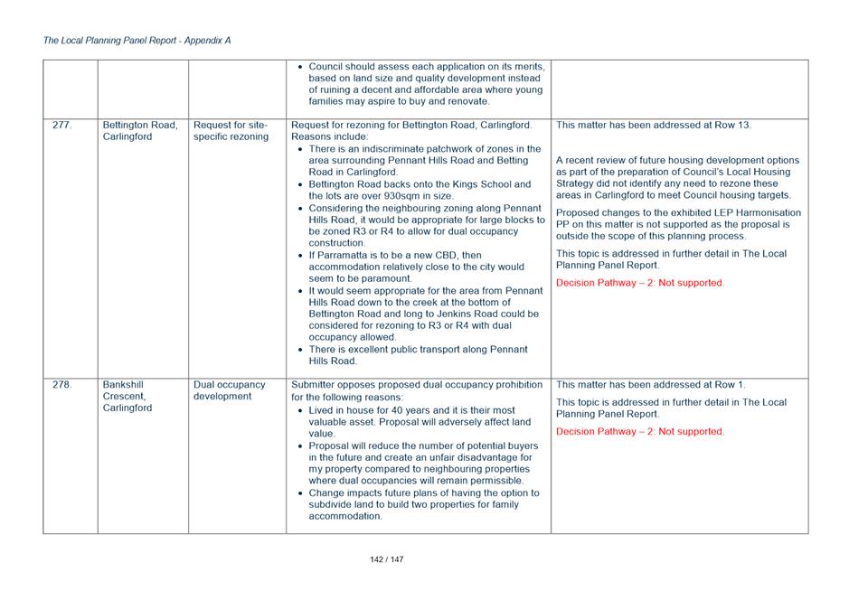
112. Land owners within the North Rocks Industrial Precinct oppose prohibition of these land uses and argue that that a key concern is that the precinct is under performing, demonstrated by increasing vacancies.
113. A submission requests greater diversity in land uses typologies in the precinct or consideration of rezoning to allow mixed use development.
Response
114. The proposal to standardise land uses permitted in all the IN1 Industrial zones across the LGA needs to take into consideration the appropriateness of the uses in an industrial context. The operation of child care centres and tourist and visitor accommodation in industrial zones is not supported. It is not recommended that child care centres be permitted in industrial zones where children are more likely to be exposed to undesirable risks. The promotion of tourist and visitor accommodation in industrial zones is not consistent considered desirable as generally these uses should be promoted in areas with better transport options and supporting services and facilities.
115. If an industrial precinct the scale of the North Rocks precinct is struggling there are limited options available to address this under the Standard Instrument LEP, which discourages precinct specific controls in order to increase standardisation of controls across the entire planning system. Should the owners/operators have suggestions on how planning controls might be reconsidered to help improve the vibrancy and use of the centre, Council Officers are willing to consider these options but they should be focused on promoting employment uses, rather than additional uses which are not compatible.
116. Any other opportunities will need to be dealt with via a separate Planning Proposal process as the Harmonisation Planning Proposal process objective is to consolidate the different plans not introduce new policy settings.
117. The proposed changes suggested in submissions for the exhibited Harmonisation PP are not supported as the proposal is outside the scope of this planning process.
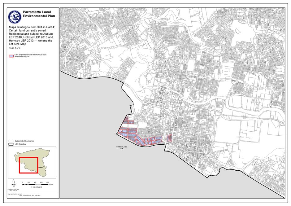
Key Issue 11 - Minimum Lot Size in R2 Low Density Residential Zones
118. Submissions were received in relation to (generally) the minimum lot size for standard residential lots in a subdivision. Most of the submissions raised concerns about the proposed change in the former Hornsby LGA where the control increases from 500sqm to 550sqm. The minimum lot size for the former The Hills area is retained at 700sqm and there is no change to the lots size in the former Parramatta areas as the 550sqm controls is retained. Battle-axe lots require a Minimum Lot Size (MLS) of 670sqm across the LGA. Submissions were lodged raising objections to the 700sqm control in the former The Hills and the 550sqm being applied to the remainder of the LGA. A single objection was received to the battle axe minimum lot size.
119. The majority of submissions were from landowners in Epping stating concerns that this would impact on their ability to subdivide their properties. The main issue was their loss of development opportunity with some submissions mentioning the need for increased housing supply.
Response
120. The approach when reviewing these controls was to make the minimum lot size more consistent. Changing the minimum lot size can have an impact on the density of development and the character of the area as smaller lots means dwellings located much closer together that larger lots.
121. The character of an area will not be impacted by a minimal increase in minimum site area from 500sqm to 550sqm. However a change from 500sqm to 700sqm would have a much more significant impact. Therefore to maximise consistency whilst still retaining the different character of the areas two minimum lot sizes of 550sqm and 700sqm are appropriate.
122. Completion of Council’s Local Housing Strategy has confirmed there is no need to lower the minimum lot size to assist with housing supply as Council can meet its targets without having to rely on this policy change.
123. Whilst it is acknowledged that some owners may be restricted from subdividing their sites, in Epping in particular no strategic justification has been demonstrated for Council changing its exhibited position on minimum lot size. In addition landowners can seek to vary the control if they can justify it on a site specific basis as part of any development application.
Key Issue 12 – Application of FSR in R4 High Density Zones
124. The exhibited Planning Proposal proposes to apply a FSR, matched to the existing height control, to R4 zoned sites where no FSR control is currently applied under the Hornsby LEP 2013 and Parramatta (former The Hills) LEP 2012. The FSR varies depending on the height and other controls that apply based on a detailed assessment by Council’s Urban Design Team. There are no proposed changes to the height of building controls in these areas.
125. The Harmonisation PP identified that applying an FSR to sites where there is currently not one will provide greater certainty to landowners and the community as to the density outcomes sought on the site.
126. Submissions were received from 11 owners in relation to changes to FSR in R4 zones. All submissions related to Epping and Carlingford sites. The majority of submissions requested that no FSR be applied or Council consider a higher FSR without specifying the FSR requested except in the three cases in Table 2 below:
Table 2 – Request for Alternate FSR for R4 zoned sites in Epping/Carlingford
|
Site/s |
Proposed in Exhibited PP |
Submission Request |
|
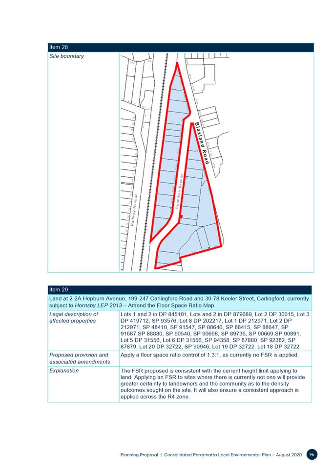
2 and 2a Hepburn Avenue and 199-203 Carlingford Road, Carlingford |
1.3:1 |
1.65:1 FSR approved under DA/863/2016 |
|
45-53 Oxford Street, Epping |
3.8:1 |
6.6:1 FSR approved under DA/646/2019 |
|
2-16 Epping Road and 2-4 Forest Grove, Epping |
Part 2:1 and 1.4:1 |
2.5:1 proposed under DA/397/2020. Lodged July 2020, refused and going to LEC. |
127. Arguments put forward in support of these requests included:
· Proposed FSR is inconsistent with development approved or currently under assessment
· Insufficient urban design information has been released to enable the public to understand the proposed density and development potential. It is unclear how the proposed FSR has been determined
· The proposed FSR will restrict development and is considered a substantive change beyond the objectives of a consolidation LEP planning proposal.
Response:
128. Council has reviewed the development applications lodged and also the planning appeals made. All matters considered were assessed without an FSR control in place. Sites were examined on a bespoke basis as there was no strategic planning control set. The Oxford Street site was a unique example due to mixed use components that do not apply to most other sites.
129. Council's Urban Design team advised that without an FSR control in the LEP the assessment of built form and scale must be done on a case-by-case basis which is extremely time consuming both for Council and the applicant. This also does not provide a community agreed, transparent and long-term future direction.
130. Adding a FSR control will provide greater certainty and transparency for council, community and applicants.
131. The Urban Design team confirmed that the proposed FSR provides adequate development capacity consistent with Council strategic housing supply objectives.
132. The purpose of the LEP Harmonisation Planning Proposal is to consolidate former LEPs and provide consistent land use and development controls across the LGA. It is Council’s intent to apply a FSR to all residential zoned land across the LGA for consistency and provide greater certainty of development outcomes for the community. The application of a FSR control to R4 zoned land, such as in Epping, would provide greater clarity for the assessment of development applications, and FSR controls are proposed that are consistent with strategic plans for identified centres.
133. Proposed changes detailed in submissions to the exhibited PP for the FSR applied in R4 zones are not supported for the reasons detailed above.
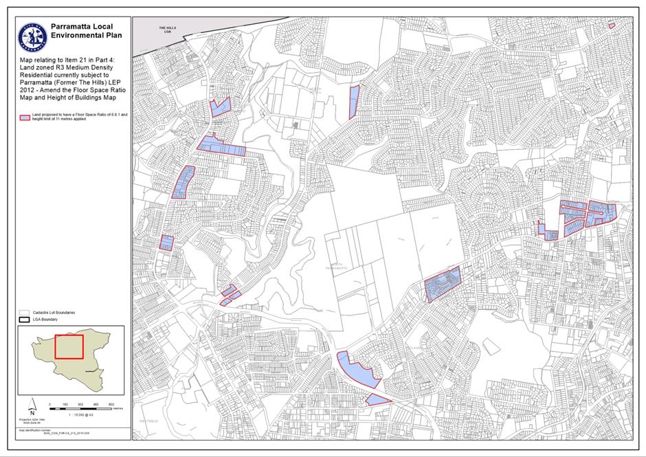
Key Issue 13 - Application of FSR in R3 Medium Density Residential Zones
134. In summary, the PP proposes to apply a FSR of 0.6:1 to R3 Medium Density Residential land in the former Hornsby and Parramatta LGAs, where no FSR applies. It also proposes to reduce the FSR for R3 land in Silverwater from 0.75:1 to 0.6:1 in the Auburn LGA. This change in Silverwater will affect approximately 212 properties.
135. Six objections were received in relation to changes to FSR in R3 zones. 3 from Silverwater landowners; 2 from Epping landowners and 1 from a Carlingford landowner.
136. In Epping and Carlingford the concern was that the density the developer/landowner could achieve would be lower than what would be achieved if no FSR was applied. However in Silverwater the following issues were raised:
· The proposed FSR changes go against the planning proposal’s overall objective and reduce the permissible development capacity for property owners
· Why have changes been proposed for Silverwater and not Newington
· The proposed changes in FSR do not meet the housing needs of the Silverwater community
· Overlooks the existing provisions of Clause 4.4 (2A) in the Auburn LEP, which enables higher FSR for multi-dwelling housing. Removing this provision will stifle the delivery of multi-dwelling townhouses that have become common in the area.
Response
137. The reasons it is important to apply a FSR are discussed in the response in the previous section that deals with the application of an FSR in the R4 zone.
138. The purpose of the LEP Harmonisation Planning Proposal is to consolidate former LEPs and provide consistent land use and development controls across the LGA. It is Council’s intent to apply a FSR of 0.6:1 to all R3 zoned land across the LGA for consistency and provide greater certainty of development outcomes for the community.
139. Council’s Urban Design team has reviewed the proposed controls for the R3 precinct in Silverwater where the FSR is proposed to be decreased and confirmed appropriate scale of built form can be achieved under the proposed 0.6:1 FSR and 11m height of building control. They consider that the higher densities previously proposed do not achieve optimal design outcomes.
140. The changes to the FSR controls requested in submissions are not supported for the reasons detailed above.
Key Issue 14 – Introducing an FSR into R2 Low Density Residential Zones
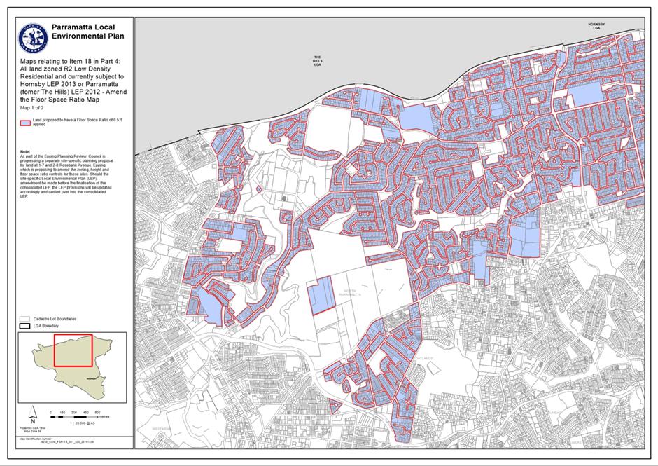
141. The Planning Proposal seeks to apply a FSR of 0.5:1 to R2 zoned land in former Hornsby and The Hills areas where no FSR currently applies, consistent with R2 zoned land in other parts of the LGA. A FSR of 0.5:1 is typical across most low density zones in Sydney. Such an approach will help maintain the low density character of these neighborhoods.
142. The area affected by this change can be seen at Figure 6 below.
Figure 6 - FSR in R2 Low Density Residential Zones
143. A total of 10 objections were made in relation to this issue. Concerns were raised relating to possible loss of development potential, including current development matters and the potential for more legal challenges in Court. Claims were made that FSR in excess of 0.5:1 could be achieved in locations where there is currently no FSR available.
Response
144. The reasons it is important to apply an FSR are discussed in the response in the previous section that deals with the application of the FSR in the R4 zone.
145. The purpose of the LEP Harmonisation Planning Proposal is to consolidate former LEPs and provide consistent land use and development controls across the LGA. It is Council’s intent to apply a FSR of 0.5:1 to all R2 zoned land across the LGA for consistency and provide greater certainty of development outcomes for the community compared to what was previously provided in the former The Hills and Hornsby planning controls where no FSR was specified.
146. It is acknowledged that in some cases sites may have been able to achieve a FSR greater than the 0.5:1 proposed but 0.5:1 is a commonly used density for low density zones across Western Sydney and requests for variations can still be made as part of the development application process where it can be justified on a case by case basis. In order to retain some consistency in the policy framework the requests for Council to apply a different FSR to areas formerly in the hills and Hornsby are not supported.
Key Issue 15 Requests for Upzonings to Rezone Site from R2 to R3 or R4 to Allow Greater Development Potential
147. Council received 11 submissions seeking to rezone sites from R2 to either R3 or R4 to increase the permitted density and allow owners sites to be redeveloped. Many of these are in Epping but requests in other parts of the LGA were also submitted. The most common justification was that Council should be giving more opportunity to landowners and making better use of transport infrastructure to increase housing supply by rezoning sites to R3 or R4.
Response
148. Proposals to rezone sites to R3 or R4 across the LGA are not supported for the following reasons:
• The Harmonisation Planning Proposal objective is not to introduce new policy positions but to consolidate the various LEPs that apply and retain a policy neutral setting
• It is not appropriate for the Harmonisation Planning Proposal process to increase densities on specific sites without a detailed assessment undertaken via a Planning Proposal process with proper neighbour consultation. Amending the zoning without a more robust process is not appropriate
• Even if the Harmonisation Planning Proposal was seeking to consider increasing the quantity of R3 and/or R4 zoned land the proposals put forward are not consistent with Council’s recently endorsed Housing Strategy and are unlikely to be supported on planning merit grounds
• The proposals to increase density in Epping are not supported due to traffic constraints. The only rezoning of land to R4 in Epping being considered are those already being progressed via separate processes following the Epping Planning Review completed in 2018.
CHANGES TO THE PLANNING PROPOSAL, DRAFT PLEP 2021 AMENDMENT INSTRUMENT AND DRAFT PLEP 2021 AMENDMENT MAPS
149. As a result of the feedback received during the exhibition of the Harmonisation Planning Proposal documentation should only be amended to include the changes detailed above and described in Attachment 13 Table 1. Other minor changes not arising from submissions will be made to deal with the issues identified below.
150. The changes to the Harmonisation PP documentation have been informed by:
· Minor drafting errors / technical changes. In this regard it is recommended that two minor mapping errors will be corrected on land at Dunrossil Avenue and 725 Blaxland Road, Epping. These changes have no policy impacts and simply resolve errors identified on the maps
· Changes arising from new State Government policy introduced since the commencement of the exhibition period of an administrative nature that do not change any policy settings.
· Changes from Site Specific Planning Proposals that have been finalised since the commencement of the Harmonisation Planning Proposal exhibition period.
151. It is proposed to update the name of the written instrument to include 2021, in anticipation of its finalisation this year.
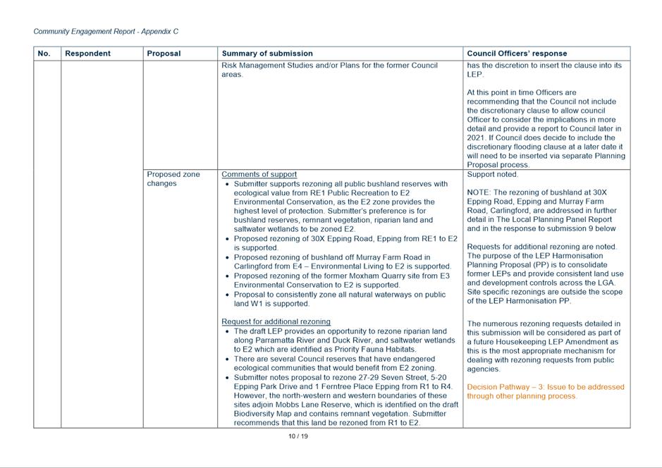
NSW Government’s Flood Prone Land Package
152. The DPIE has updated a package of materials relating to the management of flood-prone land. The package commences on 14 July 2021 and includes two new standard instrument LEP clauses (one mandatory and one optional). The mandatory ‘Flood Planning’ LEP clause applies to land within the Flood Planning Area (FPA), being land below the Flood Planning Level. A SEPP amendment will introduce this new mandatory clause and replace Council’s existing flood planning clause. In the Draft PLEP 2021 Amendment Instrument Harmonisation LEP at Attachment 2, this new mandatory clause will replace draft Clause 6.3 Flood planning.
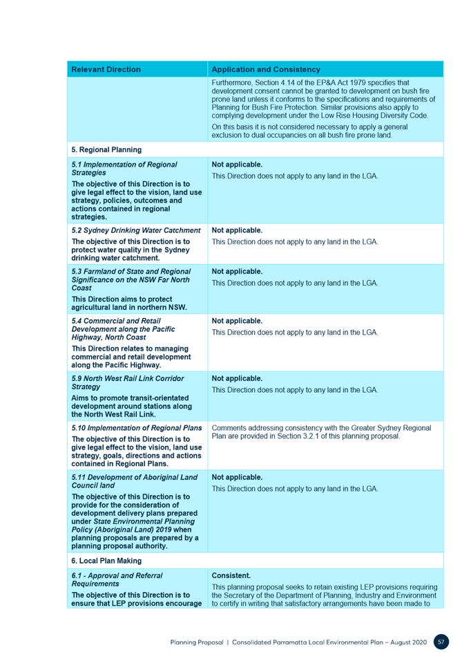
153. Councils could also express an interest to DPIE by 30 June 2021 about whether they want the new optional ‘Special Flood Considerations’ LEP clause to be included in their LEP. This optional LEP clause applies to land between the FPA and the Probable Maximum Flood (PMF) and is expected to be introduced via a second SEPP amendment for interested councils sometime later this year. Given the timing of the commencement of the NSW Government’s flood prone land package and this report to Council seeking endorsement to forward the Harmonisation Planning Proposal to the Department for finalisation, inclusion at this time of the new optional ‘Special Flood Considerations’ LEP clause is not possible. Following proper consideration of the new optional ‘Special Flood Considerations’ LEP clause by Council’s Floodplain Risk Management Committee, Council officers and Councillors, the new clause can be investigated for potential application in the LGA at any time via a Council-initiated site-specific Planning Proposal process.
154. The other materials within the updated flood-prone land package do not have direct implications for Council’s endorsement of the Harmonisation Planning Proposal and can be viewed on the Departments website link here https://www.planning.nsw.gov.au/flooding.
CONCLUSION
155. The public exhibition of the Harmonisation Planning Proposal is now complete. Submissions have been considered and minor changes are suggested none of what involve significant policy changes for Council. Council is now in a position to finalise the Harmonisation Planning Proposal and forward it to the DPIE to make the new LEP.
156. Council officers consider it is important to finalise the Harmonisation Planning Proposal as soon as possible. This will establish Council’s policy direction, and enable progression of other work to support best planning practice in the LGA. It will help establish a clear and consistent planning policy direction across the whole of the “new” Parramatta LGA.
Shari Driver
Land Use Planning Manager
Robert Cologna
Acting Group Manager, City Planning
David Birds
Acting Executive Director, City Planning & Design
|
1⇩ |
PLANNING PROPOSAL (Excluding appendices) |
136 Pages |
|
|
2⇩ |
PLANNING PROPOSAL - Appendix 1 - Proposed Draft LEP 2021 |
155 Pages |
|
|
3⇩ |
PLANNING PROPOSAL - Appendix 2 - Comparison of LEP Instruments |
24 Pages |
|
|
4⇩ |
PLANNING PROPOSAL - Appendix 3 - Comparison of LEP Land Use Tables |
59 Pages |
|
|
5⇩ |
PLANNING PROPOSAL - Appendix 4 - Land Application Map |
1 Page |
|
|
6⇩ |
PLANNING PROPOSAL - Appendix 8 - Proposed Mapping |
33 Pages |
|
|
7⇩ |
PLANNING PROPOSAL - Appendix 9 - Quantitative Analysis of Proposed Changes to Residential Zones |
16 Pages |
|
|
8⇩ |
GATEWAY DETERMINATION |
4 Pages |
|
|
9⇩ |
COMMUNITY ENGAGEMENT REPORT (Excluding appendices) |
16 Pages |
|
|
10⇩ |
COMMUNITY ENGAGEMENT REPORT - Appendix A - Landowner, Resident and Individual Submission Summaries |
147 Pages |
|
|
11⇩ |
COMMUNITY ENGAGEMENT REPORT - Appendix B - Institutions, Organisations and Consultants Submission Summaries |
23 Pages |
|
|
12⇩ |
COMMUNITY ENGAGEMENT REPORT - Appendix C - Public Authorities, Services Providers and Elected Officials Submission Summaries |
19 Pages |
|
|
13⇩ |
SUMMARY OF COUNCIL OFFICER RECOMMENDATIONS |
4 Pages |
|
|
14⇩ |
MAP OF COMMUNITY VIEWS ON DUAL OCCUPANCY DEVELOPMENT - Harmonisation PP |
1 Page |
|
REFERENCE MATERIAL