|
Previous Report
regarding the Merrylands RDS Area considered at the Council Meeting on 24
November 2008 |
|
Item 7.4 - Attachment 1 |
Previous Report
regarding the Merrylands RDS Area considered at the Council Meeting on 24
November 2008 |
CITY DEVELOPMENT
ITEM NUMBER 10.1
SUBJECT Merrylands RDS
Area (Further Report)
REFERENCE F2006/01198 - D01049777
REPORT OF
|
PURPOSE: This report seeks Council’s endorsement of
draft planning controls for the centre of Merrylands for inclusion in draft
Parramatta Local Environmental Plan (LEP) 2008. Council previously considered
the draft planning controls for this centre at its meeting on the Council should adopt draft planning
controls for Merrylands so that these can be included in draft Parramatta LEP
2008 and be provided to the Department of Planning for consideration along
with the rest of the draft plan as part of the process of gaining approval to
exhibit the draft plan. |
|
(a) That Council adopt the draft
planning controls for the RDS Centre of Merrylands as shown at Attachment 2 (Option 1), and that
these be incorporated into the draft Parramatta Local Environmental Plan 2008
prior to its exhibition. |
BACKGROUND
1. As provided in the detailed report at Attachment 1, Council previously
considered draft planning controls for Merrylands (known as options 1 and 2) at
its meeting on
2. At the meeting of the
(a) That Council adopt the draft planning
controls for the RDS Centres of Carlingford and East Rydalmere, as shown at
Attachment 2 of Manager Land Use & Transport Planning Report, and that
these be incorporated into the draft Parramatta Local Environmental Plan 2008
prior to its exhibition.
(b) That the draft planning controls for
Merrylands be deferred and council officers undertake further analysis of the
petitions tabled tonight, particularly in relation to the width of Smythe
Street and in this regard, an audit of Smythe Street width be undertaken.
(c) That an analysis be undertaken of new areas per
zone in each of the scenarios.
(d) Further, that the petition from residents
of
SUMMARY OF THE
ANALYSIS
Petitions,
submissions and public forum
3. Three (3) petitions and one (1) submission
were made to Council in respect of the draft planning controls. One petition
and one submission were in support of Option 1, a second petition was in
support of Option 1, subject to
4. A detailed plan of
5. Smythe Street is intended as a slow
vehicle movement area and it is considered that the current configuration of
6. A number of residents of
Area per zone
7. As required by Council’s resolution of
PREFERRED OPTION
8. The recommended planning controls, being
Option 1, will focus increased residential density in the northern portion of
the precinct, whilst retaining the southern portion as a low density
residential area, underpinning the area’s potential to accommodate further
residential development in the longer term. It provides a practical and
sustainable approach to planning and recognises that redevelopment of the
Merrylands RDS centre should be allowed to proceed in stages.
NEXT STEPS
9. This report details the preferred zoning,
height and density options for Council to consider. Once the draft planning
controls have been adopted by Council they will be included as part of draft
Parramatta LEP 2008. The draft LEP must undergo a review by the Department of
Planning as part of the process of seeking State Government approval to place
the plan on public exhibition. It is anticipated this review will be completed
in the coming months, following which the draft LEP will be reported to Council
for endorsement enabling a formal request to the Department of Planning for
approval to exhibit. Subject to this process it is anticipated that the draft
LEP and DCP could be exhibited in early to mid 2009.
10. Draft DCP controls will also be formulated,
to provide more detailed planning guidance on built form outcomes, desired
streetscape, building setbacks, future character, desired future pedestrian
connections etc and will be reported for Council’s consideration.
Diane Galea Sue
Stewart
Project Officer Acting
Manager
Land Use &
Transport Planning Land Use & Transport Planning
|
Detailed Report Deferred Areas November
2008 |
7 Pages |
|
|
|
Option 1 Merrylands |
3 Pages |
|
|
|
Option 2 Merrylands |
4 Pages |
|
|
|
Detailed Report Deferred Areas June 2008 |
8 Pages |
|
|
|
Public Forum Address & Reply |
3 Pages |
|
|
|
|
1 Page |
|
REFERENCE MATERIAL
|
Previous Report
regarding the Merrylands RDS Area considered at the Council Meeting on 24
November 2008 |
Attachment 1
DETAILED REPORT ON DRAFT PLANNING CONTROLS
FOR MERRYLANDS
BACKGROUND
Council previously considered draft planning controls for Merrylands,
known as Option 1 (Attachment 2) and
Option 2 (Attachment 3) at its
meeting of
Option 1 seeks to focus increased
residential density in the northern portion of the precinct, whilst retaining
the southern portion as a low density residential area, underpinning the area’s
potential to accommodate further residential development in the longer term.
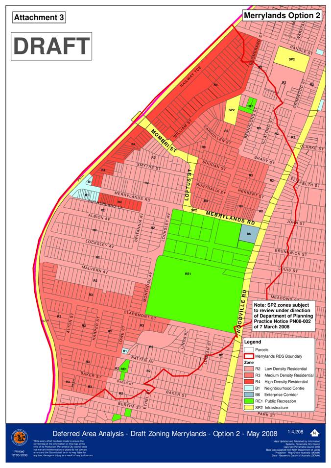
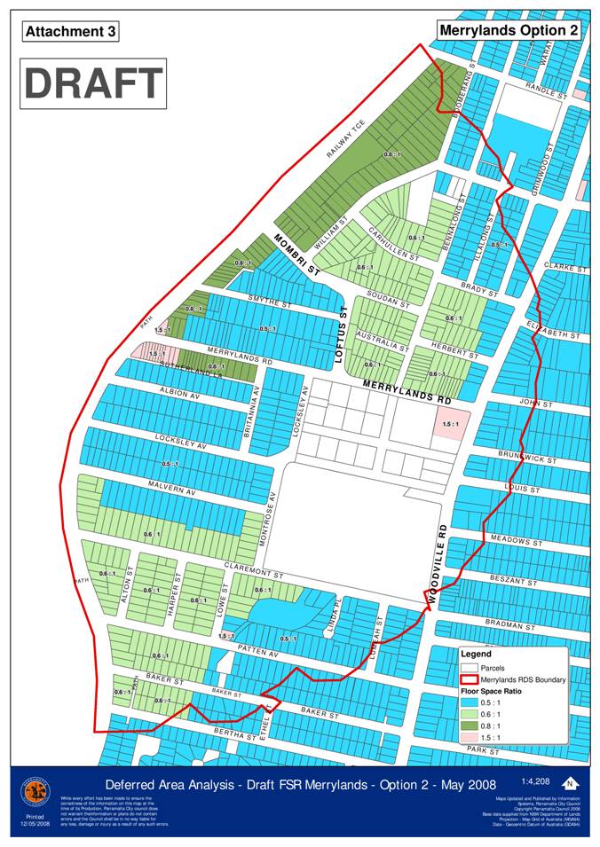
Option 2 seeks to retain existing densities,
with the exception of land bounded by
The decision of Council at the
(a) That Council adopt
the draft planning controls for the RDS Centres of Carlingford and East
Rydalmere, as shown at Attachment 2 of Manager Land Use & Transport
Planning Report, and that these be incorporated into the draft Parramatta Local
Environmental Plan 2008 prior to its exhibition.
(b) That
the draft planning controls for Merrylands be deferred and council officers
undertake further analysis of the petitions tabled tonight, particularly in
relation to the width of Smythe Street and in this regard, an audit of Smythe
Street width be undertaken.
(c) That an analysis be undertaken of new areas per
zone in each of the scenarios.
(d) Further, that the
petition from residents of
PETITIONS,
SUBMISSIONS & PUBLIC FORUM
Three (3) petitions and one (1) submission
were made to Council in respect of the draft planning controls that were
initially presented to Council on
Table
1:
Summary of petitions and submissions received
|
PETITION/SUBMISSION AUTHOR |
SUMMARY |
COMMENT |
|
Petition
from residents of Railway Terrace, |
Petition of 20 signatories (represents 19 properties) in support of
Option 1, which allows for mixed use development up to six storeys in height
between Railway Terrace, |
This petition supports Option 1 in its current form and does not seek
any amendments. |
|
Petition
& Public Forum Address from residents of Smythe Street, Merrylands |
Petition of 30 signatories (represents 9 properties) in support of
Option 2, to have the area remain at its present densities.
A representative of this petition also addressed Council at its meeting of · Lack of public
consultation; · Current parking congestion in · Narrow width of · Amenity impacts
of higher density developments. |
The issues raised during the public forum address were responded to at
the Council meeting of It should be noted that Option 2 proposes that land in |
|
Petition
from residents of Albion Street, Merrylands |
Petition of 33 signatories (representing 32 properties) of which 10
signatories stated an address outside of |
Further consideration of this matter is provided below. |
|
Submission
from resident of |
Submission in support of Option 1 for higher density development. |
This submission supports Option 1 in its current form and does not
seek any amendments. |
Concern was raised by some Councillors and
residents about the width of
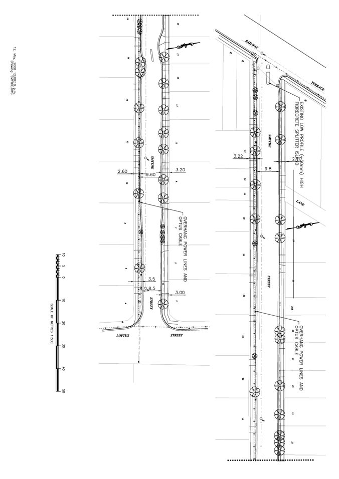
A detailed plan of
Council’s Transport & Traffic
Service Manager and Civil Design staff have previously advised that a minimum
road width of 9.4 metres is sufficient to enable 2 metres for vehicle car
parking on either side, whilst allowing 2.7 metres per vehicle travelling lane
in each direction. This is achieved over 78% of
Given the characteristics of the
road and its function, it is recommended that the current configuration of
However, there are various ways
Council could improve traffic flow in
(1) Council could widen the
The costs
associated with road widening would include realignment of kerb and guttering,
extension of road pavement, removal and replacement of existing trees,
potential realignment of the footpath/s and potential relocation of services.
Initial investigations of existing services reveal that the northern side of
the road reserve contains Telstra lines and gas pipes, while the southern side
contains Telstra lines, water pipes, underground and overhead power lines and
Optus cables.
Without a detailed working design/scope of works of any such road widening it is difficult to accurately determine the costs associated with undertaking the project. However an approximate cost of civil works associated with widening the road by approximately 0.5 metre along one side, including kerb and gutter realignment and extension of the roadway, has been estimated at approximately $100,000. This does not include the relocation of services, tree removal and replacement, or any other contingencies. While the cost associated with relocating services is generally determined on a case by case basis, it is reasonable to expect a significant increase to the total cost, taking into account what is likely to be involved.
(2) Council’s Traffic and
Transport Services Manager has advised that traffic calming devices including
line marking and speed humps could be provided to contain vehicle speeds and to
help guide motorists. Such works are estimated to cost approximately $10,000.
(3) Monitoring of traffic conditions over the longer term could also allow Council to consider other alternatives, including restricting parking to one side of the roadway only or altering vehicle movements to ‘one way’.
Funding options to undertake road works would need to be explored including through the use of Section 94A funds. However, this would require the amendment of the S94A plan to identify the road improvements to be undertaken in the schedule of works.
A number of residents of
Albion Street and adjoining streets to the
south are suitably located to accommodate increased residential or mixed use
development given their proximity to Merrylands train station and Merrylands
town centre, regular shaped allotments, generous street widths and relatively
flat topography.
Under Option 1, land south of
Rezoning greater volumes of the
RDS study area, including
· Recent
redevelopment uptake has predominantly occurred along Railway Terrace,
· Holroyd Council has provided
opportunities for substantial redevelopment on the opposite side of the train
line which will cater for a large proportion of housing demand in the short to
medium term.
· Providing a mix of residential zoning and
densities, allows for a mix of dwelling types to be provided within the
community.
· Previous discussions with Councillors
demonstrate that many local residents believed that the area had local heritage
significance but were reluctant to have formal heritage listing. This and the
contents of the petition received would suggest that a more measured, long term
approach needs to be adopted for the planning controls for this area.
It is recommended that the area
south of
AREAS
PER ZONE
As required by Council’s resolution of
As detailed in the table below, Option 1
would result in 56% of the land area being zoned for low density residential
(R2), 14.1% for medium density residential (R3), 25.5% for high density
residential (R4) and 2.7% for mixed use development (B4). The remaining 1.7%
would constitute Neighbourhood Centre or Enterprise Corridor zones.
In comparison, Option 2 would provide less
land area zoned for low density residential (49%) and high density residential
(14.1%), but substantially increases the land area zoned for medium density
housing (35.1%). No mixed use zoning would be provided under Option 2, and the
area zoned Neighbourhood Centre and Enterprise Corridor would remain consistent
with Option 1.
The gross floor area figures provided in
Table 2 take into consideration proposed floor space ratio. Option 1 would
generate a greater amount of residential and commercial gross floor space while
retaining a larger area of low density land to be retained for future long term
growth.
Table
2:
Land area and potential gross floor area (GFA) for Option 1 and Option 2
|
ZONE |
OPTION 1 (Land area m²)* |
OPTION 1 (Gross GFA)** |
OPTION 1 ( |
OPTION 2 (Land area m²)* |
OPTION 2 (Gross GFA)** |
OPTION 2 ( |
|
R2 Low Density Residential |
275,279 |
137,640 |
56% |
241,355 |
120,768 |
49% |
|
R3 Medium Density Residential |
69,632 |
41,779 |
14.1% |
172,285 |
103,371 |
35.1% |
|
R4 High Density Residential |
125,571 |
120,793 |
25.5% |
69,563 |
55,650 |
14.1% |
|
B1 Neighbourhood Centre |
3,805 |
5,708 |
0.8% |
4,317 |
6,476 |
0.9% |
|
B4 Mixed Use |
13,233 |
26,466 |
2.7% |
N/A |
N/A |
0 |
|
B6 |
4,165 |
6,248 |
0.9% |
4,165 |
6,248 |
0.9% |
|
TOTAL |
491,685 m² |
338,634 m² |
100% |
491,685 m² |
292,513 m² |
100% |
*
These figures are approximate only.
*
These gross floor areas are indicative only and represent land area x floor
space ratio for each option. No allowance is made for existing GFA nor possible
impediments to redevelopment including recent redevelopment, strata
subdivision, heritage etc.
PUBLIC
CONSULTATION
The community will have the opportunity
to provide comment to Council on the draft planning controls during the
exhibition of the Draft LEP. This exhibition is likely to be conducted over a 2
month period to enable all stakeholders opportunities for comment. Council will
consider all submissions before any final decision is made.
PREFERRED OPTION
The recommended planning controls, being
Option 1, will focus increased residential density in the northern portion of
the precinct, whilst retaining the southern portion as a low density residential
area, underpinning the area’s potential to accommodate further residential
development in the longer term.
Option 2 would result in the fragmentation of high and medium density
areas over the Merrylands RDS precinct limit the long term growth potential of
Merrylands and may also result in a more inconsistent built form throughout the
precinct.
NEXT STEPS
This report details the preferred zoning, height and density options for Council to consider. Once the draft planning controls have been adopted by Council they will be included as part of draft Parramatta LEP 2008.
The draft LEP must undergo a review by the Department of Planning to confirm its consistency with the State Government’s standardised LEP format and State policies. This review is underway and when completed, the draft LEP will be reported back to Council (with advice about the outcome of the review) so that Council can formally lodge the draft plan with the Department of Planning and request approval (under Section 65 of the Act) to publicly exhibit the draft plan. Subject to this process, it is anticipated the draft LEP could be placed on public exhibition in early to mid 2009.
Draft DCP controls will also be
formulated, to provide more detailed planning guidance on built form outcomes,
desired streetscape, building setbacks, future character, desired future
pedestrian connections etc and will be reported for Council’s consideration.
These controls will form part of the draft Parramatta Development Control Plan
2008 to guide future development in each precinct, and will be reported to
Council.
|
Previous Report
regarding the Merrylands RDS Area considered at the Council Meeting on 24
November 2008 |
|
Previous Report
regarding the Merrylands RDS Area considered at the Council Meeting on 24
November 2008 |
|
Previous Report
regarding the Merrylands RDS Area considered at the Council Meeting on 24
November 2008 |
DETAILED REPORT ON DRAFT
PLANNING CONTROLS FOR
MERRYLANDS, CARLINGFORD &
BACKGROUND
In November 2006, Council adopted a revised Residential Development
Strategy (RDS) to respond to future population growth and housing demand in
To manage new residential development, the RDS proposes a ‘concentrated
growth’ model. This would allow more intense housing development to occur in
areas or ‘centres’ which can best support such growth. Typically, these areas
are close to public transport, shops and community facilities.
In adopting the RDS, Council deferred some of the ‘centres’ for
consideration at a later date. Merrylands, Carlingford and
In translating the RDS into the draft Parramatta Local Environmental
Plan (LEP), Council in May 2007 adopted the draft Parramatta LEP 2008 which
proposed to downzone some areas within the study areas of Merrylands,
Carlingford and East Rydalmere that are currently zoned Residential 2(b). This
was to preserve the land from ad-hoc development in the short term until
decisions on its future development capacity were made. (Note: The existing
areas zoned Residential 2(c) within these areas were proposed to be retained in
the equivalent R4 High Density Residential Zone under the draft LEP).
In October 2007, the Department of Planning (DoP) advised Council that
there were a number of outstanding issues that prevented the DoP from
authorising a Section 65 Certificate enabling the draft Parramatta LEP to be
formally exhibited. One of the issues raised by the DoP was that deferred areas
where down-zoning was proposed would not be supported. At its meeting of the
‘That Council note the advice of the Minister for Planning on 24
October that:-
1. The
Department of Planning will not accept the down-zoning of deferred areas and
therefore Council proceed immediately to prepare detailed analysis of these
areas leading to zoning and built form controls in the draft Parramatta LEP
2008.’
As a consequence, an assessment of the deferred areas of Merrylands,
Carlingford and
THE DEFERRED AREAS
This report focuses on the deferred areas in the RDS of Merrylands,
Carlingford and
The Merrylands Study Area is focused on the eastern side of Merrylands
Railway Station. The railway line forms
the boundary between Parramatta City Council and Holroyd City Council. A small
group of shops are located on the eastern side of the railway station. The area
surrounding these shops comprises mostly detached dwellings. The Merrylands
Town Centre is located on the western side, within the Holroyd LGA.
There are small pockets of medium and higher density housing spread
throughout the study area. The study area is relatively flat and there is a large
park (
The Carlingford Study Area is located around Carlingford Railway
Station. The study area is located on a ridge line defined by
There is a small group of shops to the south of Carlingford Railway
Station along
There are a number of heritage items in and adjacent to the study area
including bushland at Evans Road, Carlingford Memorial Park, Eric Mobbs
Memorial, K13 Memorial, Galaringi Reserve, Mobbs Hill Reserve, bushland,
fencing and bridge on Honiton Avenue, water tanks on Marsden Road, and
dwellings at Nos. 101 and 105 Adderton Road.
The East Rydalmere Study Area is located on
DEFERRED AREAS ANALYSIS
A workshop was held with
Councillors on
Merrylands
§ With access to public transport, retail and commercial services, open
space and a relatively unconstrained urban structure, Merrylands offers
opportunities for increased residential densities.
§ This area has direct pedestrian access to the railway station and
vehicular and pedestrian access to the Merrylands Town Centre. Given the
principles of transit-oriented development, the lots directly adjacent to the
station may be given comparatively more generous height and floor space
controls.
§ In the short term, it is desirable to preserve the low scale residential
character of single dwellings in the southern part of the precinct, which
contribute to the mix of housing and the amenity of the neighbourhood. In the
longer term, increased densities may be considered, as the first stage of
redevelopment is completed, and assuming that there is sufficient demand for
further housing.
§ Planning controls prepared by Holroyd Council in respect of land in that
LGA directly adjacent to the railway line allows for mixed used development
between 6 – 8 storeys in height. This also accommodates some demand for housing
development in the locality.
Carlingford
§ Carlingford has topographical and natural constraints, poor pedestrian
and vehicular connectivity and is characterised by a mix of housing including
established residential flat buildings and low scale detached housing.
Considering these constraints Carlingford study area is less likely suitable to
sustain significant housing growth.
§ Planning controls prepared by Baulkham Hills Shire Council in respect of
land on the northern side of
§ Considering the existing mix of uses in East Rydalmere, as well as its
established low scale character, it is anticipated that this study area could
sustain contained redevelopment for increased residential densities focused
around the existing ‘centre’ and close to parks and schools.
§ New mixed-use development should be focused around the current
commercial and community uses and toward the intersection of
§ Part of the study area has an established low density character with
single dwellings that are highly consistent in terms of scale, materials and
setbacks from the street. Retention of this housing in the eastern sections of
Pine and
RECOMMENDED PLANNING
CONTROLS
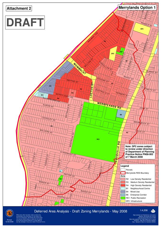
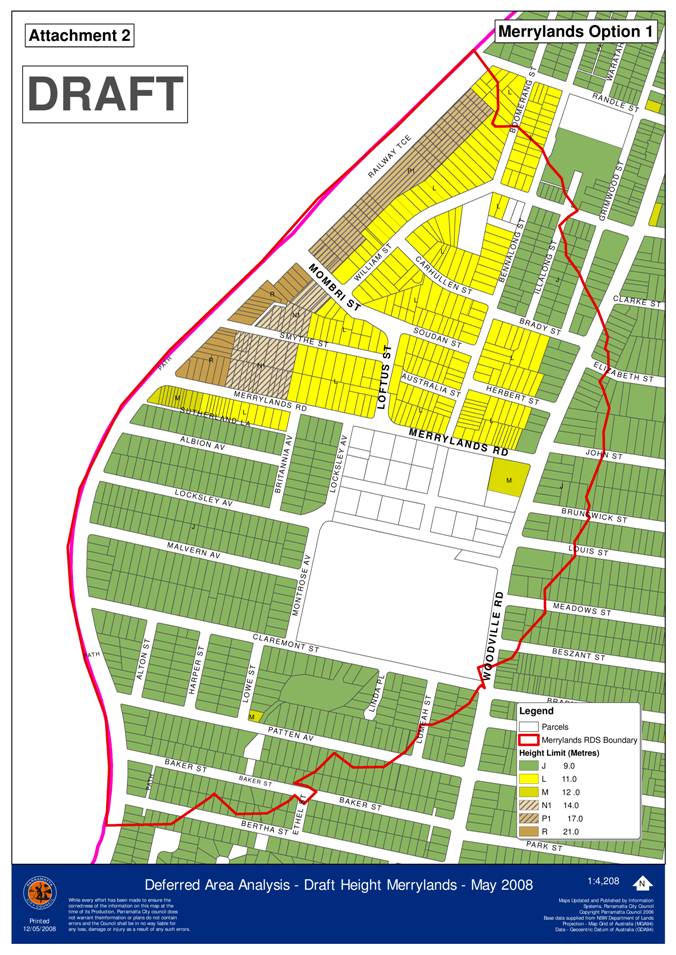
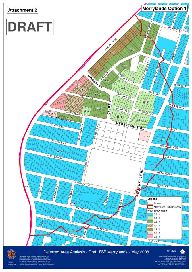
Merrylands Precinct
1. Preferred Planning Controls -
Option 1
The provision of high density
residential development near existing public transport infrastructure is
consistent with transport oriented development promoted by the NSW State
Government and Council’s RDS. Land along
The recommended draft planning
controls for Merrylands provide for increased densities concentrated along the
northern portion of the precinct, whilst allowing reduced densities within the
southern portion as outlined in Attachment
2.
It is proposed to concentrate
higher density mixed use development toward the railway line, with building
heights and densities gradually falling from west to east (towards Woodville
Road). An active street frontage to Railway Terrace is recommended, creating
opportunities for surveillance of the railway line and improved pedestrian
access between the northern portion of Railway Terrace and Merrylands Railway
Station.
Concentrating the tallest
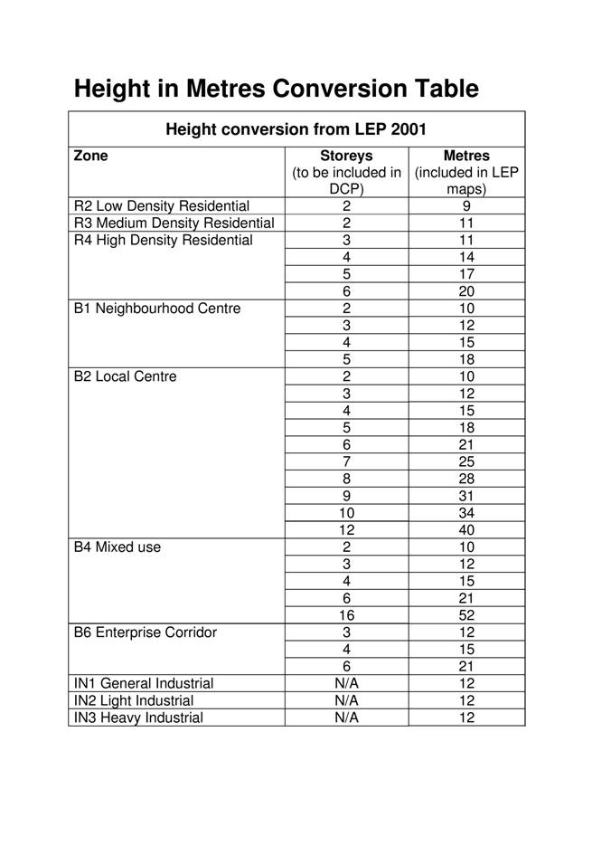
buildings (5 – 6 storeys or 17 – 21 metres proposed on the Parramatta LGA side)
closest to the railway station has also been the strategic approach of Holroyd
City Council, which allows for development between 6 – 8 storeys in this
vicinity. The area bound by
Land south of
2. Alternative Zoning based on
Department of Planning Advice – Option 2
At the Councillor workshop it was
suggested that another zoning option could be considered for Merrylands,
reflecting the advice of the Department of Planning (DoP) in its letter to Council
of
The Department’s assessment of the zoning
within the RDS included consideration of Council’s argument that down zoning
was needed to retain capacity for future higher density development. In most
cases adequate low density 2(a) land was identified in reserve, without the
need to downzone existing medium density 2(b) or high density 2(c) land. In the
case of Merrylands however, there does not appear to be adequate 2(a) land in
reserve. Therefore the Department agreed that the two street blocks closest to
the station (Mombri & Lotus Streets & Merrylands Road) could be down
zoned to allow for future higher density development.
Under this scenario of the
Department of Planning, all existing zonings of Residential 2(b) and Residential
2(c) in the Merrylands RDS precinct would be retained, with the exception of
the
Councillors may wish to consider
this option, but the recommended planning controls discussed in Option 1 above
are preferred because they make better provision for consolidated increase in
residential density in the short term as well as preserving land for longer
term growth.
Option 2 would result in the fragmentation of high and medium density
areas over the Merrylands RDS area and limit the long term growth potential of
Merrylands. It may also result in more inconsistency in built form throughout
the precinct.
3. Response to issues raised at
Councillor Workshop
Concern was raised by some
Councillors at the workshop about the width of
Options are available to improve
vehicle circulation within
Should Council wish to widen the
While an increase in traffic
volumes may be expected as a result of higher residential densities within the
locality, the proposal accords with the principles of Council’s RDS to provide
higher density housing close to centres and public transport, which provides
opportunities for reduced car movements in the longer term. Traffic speeds in
any case will be slow.
Another matter raised at the
Councillor Workshop was concern about the proximity of higher density
development in the vicinity of existing heritage items at Nos. 56 and
Carlingford Precinct
In response to a number of
constraints relating to Carlingford as previously discussed, particularly
topography and poor vehicular and pedestrian connectivity, it is recommended to
concentrate increased densities along
The draft
planning controls propose greater height and density along Pennant Hills Road
in the shopping precincts of Carlingford Village Shopping Centre at the eastern
end of the precinct and for the shops closer to Carlingford Railway Station to
encourage an upgrade of existing retail shops with shop top housing and support
their ongoing viability with increased residential population within their
catchment. It would also add to the diversity of dwelling types in the
locality.
West of the railway line it is
proposed to allow a mix of four storey (14 metres) residential flat buildings
and two storey (11 metres) townhouse style housing. This part of the precinct
also has good proximity to the Telopea RDS precinct and has already shown
potential for redevelopment with recent medium density redevelopment.
The remainder of the precinct is more suited to low density residential development. The effect of this is some proposed down zonings of residential land at the perimeter of the RDS area consistent with proposed zonings outside the RDS area, where rezoning is proposed from 2(b) Residential to R2 Low Density Residential. This is considered appropriate and justifiable to the DoP largely because of the environmental constraints and limited walkability of these areas for residents, as well as in the context of the broader RDS proposals in this locality.
Existing heritage items within the precinct are proposed to retain existing zoning equivalents.
As mentioned
previously, planning controls prepared by Baulkham Hills
Shire Council in respect of land on the northern side of
The recommended planning controls
for
Proposed zonings north of
Victoria Road seek to allow for a level of mixed use activity (3 storeys or 12
metres) to be concentrated around the intersection of Park Road and Pine
Street, building on existing activities including the church, school, hotel and
shops, and allowing future redevelopment to be focussed away from Victoria
Road. Increased residential densities are generally proposed between the
industrial area west of Myrtle Street and the eastern side of Park Road
allowing for a mix of two storey (11 metres) R3 medium density and 3 storey (11
metres) R4 high density residential zones.
Proposed zonings on the southern
side of
The southern part of the precinct
is considered appropriate for up zoning given its isolation from low density
residential areas, its proximity to open space,
Height and densities proposed
over the precinct as a whole are proposed to be relatively low scale allowing
for two and three storey developments throughout. These heights and densities
would also provide consistency where existing development has already taken
place within the 2(b) Residential Zone, particularly along
An existing heritage item and
adjoining land at
CONSULTATION
Staff from Council’s Strategic Asset Management,
Community consultation of these
deferred areas will occur with the exhibition of the draft Parramatta LEP 2008
as a whole.
NEXT STEPS
This report details the preferred
zoning, height and density options for Council to consider. Once the draft
planning controls have been adopted by Council they will be included as part of
draft Parramatta LEP 2008. Draft DCP controls will also be formulated, to
provide more detailed planning guidance on built form outcomes, desired
streetscape, building setbacks, future character, desired future pedestrian
connections etc and will be reported for Council’s consideration. These
controls will form part of the draft Parramatta Development Control Plan 2008
to guide future development in each precinct.
|
Previous Report
regarding the Merrylands RDS Area considered at the Council Meeting on 24
November 2008 |
Attachment 5 - Public forum item from Council
meeting on
Statement
on behalf of the residents of
This evening I and my fellow petitioners from Smythe Street Merrylands in the Woodville Ward would like to comment on the proposed Local Environment Plan changes to increase the urban density in our street.
Firstly, we would like to thank Councillor Garrard for alerting us to these proposed changes. Without his intervention, we would not have been aware of these matters.
This is in comparison to the Council’s excellent job in communicating the proposed changes in the previous LEP, which we felt had provided for much more community consultation.
Our main concerns in brief are:
1. Parking congestion already exists in our street as a flow-on effect after changes to the adjoining Railway Terrace.
2. The narrow width of the street makes if difficult for cars to pass and damage to property and vehicles has already occurred.
3. Several residents have recently renovated their properties after being advised in the previous LEP that the street would not be zoned for unit developments.
Parking
At the last general meeting on the 14th July, the petitioner in Railway Terrace mentioned the difficulties experienced from changes to parking availability and traffic flow due to the RTA redevelopment. This included the removal of parking from the eastern side of the street and no provision for drivers to drop off passengers for the railway station.
These issues have had a flow on effect into Smythe Street resulting in weekday parking congestion where three-quarters of the street is parked out from anywhere between 7:30am and 7:30pm, making entry and exit to one’s property difficult, with cars obscuring vision and sometimes parking over driveways. Recently we had a development of 4 townhouses in the street which has already increased vehicle density, and we are concerned about the multiple impact on street parking, 7 days a week, if the council approves up to 6 storey unit blocks.
Street width
Minutes of a previous Council
meeting state the road pavement width of
We have been told that Council would then consider either making the street open to one-way traffic flow only or making the road wider by removing trees and realigning the kerb and guttering. For the first proposal we would ask, “Where then would the current residents and commuters park?” and also “ What would be the implications for traffic flow and access?” And as for the widening of the road, “How will our streetscape look if the trees are removed?”
The question of access and traffic flow have been on the Council agenda previously where the right turn from Loftus street was terminated due to the hazard of collision and also to reduce the quantity of traffic flowing westerly down Smythe street to the Railway station. A roundabout was placed on Merrylands road to steer the majority of the traffic down Merrylands road, which is a much wider street.
Recent property
developments
We acknowledge that there is a
percentage of housing stock in
The residents ask, “What percentage of land changed to heavier density in the previous LEP has been utilised in the new zoning for high density dwellings?” We ask you to consider the current impact of density and traffic changes affecting the residents and how this impact would be multiplied if higher density dwellings were constructed in our street. We ask you to consider the impact of offending residents and commuters at the cost of appeasing developers.
We ask you to stop and assess the
impact from the grass roots level, before creating multiple dwellings leaving
little or no open space for inhabitants, no space for children to play,
increasing noise pollution and where quality of life is greatly reduced. What
statement are you sending your voters – will
We, the residents of
Response by
Acting Manager, Land Use & Transport Planning – Sue Stewart:-
Tonight, Council will be
considering two options for proposed changes to the planning controls in
1. Option 2 – Draft
Planning Controls for Merrylands
It should be
noted that under Option 2, land in
2. Public Consultation
Tonight Council is considering
which draft zoning option it wishes to be included in the draft Local
Environmental Plan when it goes on public exhibition. Residents will have the
opportunity to provide comments to Council during the exhibition. This
exhibition is likely to be conducted over a 2 month period to enable all
stakeholders opportunities for comment.
Council will consider all submissions before any final decision is made.
Properties in
4.
Amenity Impacts of Higher Density Development
Development applications for residential flat buildings are examined by
Council’s Design Review Panel to ensure that design quality and residential
amenity are satisfied. This is over and
above the normal assessment process.
Neighbouring residents also have the opportunity to comment on such
development applications and can raise any concerns about amenity or other
impacts before the application is determined by Council.